Cassowary Conservation Management Plan
6
Cassowary Conservation Management Plan Project snapshot This document is an overview of the Department of Transport and Main Roads’ (TMR) ongoing work to support the conservation of cassowaries in the North Queensland Region. The plan outlines a framework for consistency in project management and public awareness to reduce road strikes and improve cassowary conservation. Background Cassowaries live in rainforests and adjacent habitat along the east coast of Queensland, from Ingham to the tip of the Cape York Peninsula. Within this area, there is around 1000 kilometres of state-controlled roads (SCR) connecting the major regional cities of Townsville and Cairns with townships along the coast, and from Paluma through the Atherton Tablelands to Shiptons Flat near Cooktown. The southern cassowary is an iconic, culturally significant fauna unique to Queensland. Leading up to, and since 2000, there has been an increasing awareness of the impact humans are having on the state’s cassowary populations. In 1988, when the Wet Tropics was granted World Heritage Status, the main cause of cassowary decline, loss of primary habitat, was halted. This brought into focus secondary impacts on cassowary populations, of which road deaths was the primary one. With increasing human population and road usage in these areas and across the Wet Tropics road network, vehicle strike is currently the leading attributable cause of cassowary deaths. TMR has been aware of this and of the importance of cassowary conservation. Either independently or with other agencies and organisations, there has been a focus on putting into place a framework for cassowary management. Internally, evaluation of the impacts TMR’s work has on cassowaries are measured through planning, design, construction and operation as well as TMR staff and contractor interactions with cassowaries during construction and maintenance work. External evaluation includes monitoring public use of roads in cassowary habitats, reports of cassowaries on roads, and consultation with other agencies and community groups. Situation In 2020, there have been several cassowaries killed in Far North Queensland by vehicles on local and state- controlled roads, particularly on the Kennedy Highway near Kuranda and on roads around Mission Beach. This has heightened community interest and the need for a consolidated and consistent approach for the management of cassowary conservation. The Cassowary Conservation Management Plan provides a framework for this to happen; building on previous work and strategies and outlining the steps TMR is taking in the work it delivers in cassowary habitat areas in relation to project management. It also identifies what is being done externally in the areas of infrastructure, signage and passive measures to contribute to this conservation effort. Finally, the plan identifies the integral role of the community in this partnership if real outcomes are to be achieved in the short and long-term for cassowaries in these areas. Image: The road to El Arish. Credit: Tourism and Events Queensland.
Transcript of Cassowary Conservation Management Plan

Cassowary Conservation Management Plan Project snapshot This document is an overview of the Department of Transport and Main Roads’ (TMR) ongoing work to support the conservation of cassowaries in the North Queensland Region. The plan outlines a framework for consistency in project management and public awareness to reduce road strikes and improve cassowary conservation.
BackgroundCassowaries live in rainforests and adjacent habitat along the east coast of Queensland, from Ingham to the tip of the Cape York Peninsula. Within this area, there is around 1000 kilometres of state-controlled roads (SCR) connecting the major regional cities of Townsville and Cairns with townships along the coast, and from Paluma through the Atherton Tablelands to Shiptons Flat near Cooktown.The southern cassowary is an iconic, culturally significant fauna unique to Queensland. Leading up to, and since 2000, there has been an increasing awareness of the impact humans are having on the state’s cassowary populations. In 1988, when the Wet Tropics was granted World Heritage Status, the main cause of cassowary decline, loss of primary habitat, was halted. This brought into focus secondary impacts on cassowary populations, of which road deaths was the primary one. With increasing human population and road usage in these areas and across the Wet Tropics road network, vehicle strike is currently the leading attributable cause of cassowary deaths.TMR has been aware of this and of the importance of cassowary conservation. Either independently or with other agencies and organisations, there has been a focus on putting into place a framework for cassowary management.
Internally, evaluation of the impacts TMR’s work has on cassowaries are measured through planning, design, construction and operation as well as TMR staff and contractor interactions with cassowaries during construction and maintenance work. External evaluation includes monitoring public use of roads in cassowary habitats, reports of cassowaries on roads, and consultation with other agencies and community groups. SituationIn 2020, there have been several cassowaries killed in Far North Queensland by vehicles on local and state-controlled roads, particularly on the Kennedy Highway near Kuranda and on roads around Mission Beach. This has heightened community interest and the need for a consolidated and consistent approach for the management of cassowary conservation. The Cassowary Conservation Management Plan provides a framework for this to happen; building on previous work and strategies and outlining the steps TMR is taking in the work it delivers in cassowary habitat areas in relation to project management. It also identifies what is being done externally in the areas of infrastructure, signage and passive measures to contribute to this conservation effort. Finally, the plan identifies the integral role of the community in this partnership if real outcomes are to be achieved in the short and long-term for cassowaries in these areas. Image: The road to El Arish. Credit: Tourism and Events Queensland.

2
Objective of this plan This plan has been developed in line with TMR’s overarching vision of ‘creating a single integrated transport network accessible to everyone’. This encompasses the set objective of developing a road network that is accessible, safe, responsive, efficient and sustainable. The Cassowary Conservation Management Plan better positions TMR to respond to the management of cassowaries on SCR in North Queensland. This will be achieved through the development and implementation of best practice in managing cassowary interactions, from project design through to the overarching maintenance of SCR. It will also involve a broader, integrated approach encompassing all TMR operations within cassowary habitat; building on the learnings from previous work in this area, including zoning and the implementation of cassowary-sensitive measures.Finally, the plan will look towards working with the community to ensure they are partners in this to protect local cassowary populations.
Focus locationsA review of cassowary sightings since 2015 provides information regarding their location and populations (as indicated in the map to the right).Taking into consideration the areas frequented by people and cassowary reporting, Mission Beach and Mourilyan Harbour areas remain ‘hot spots’ for cassowary reporting. Kuranda and the Tully/Tully Gorge Road also having a high incidence of sightings, and Daintree, southern Atherton Tablelands, Bramston Beach and Cardwell areas all have levels of reported sightings.Consideration has also been given to reported cassowary vehicle strikes. Between 1996 and 2018, there have been 236 cassowary deaths recorded. Of these, 174 were attributed to vehicle strike. This information provides a holistic overview of cassowary activity areas that have informed the locations of focus for this plan.
Map of cassowary sightings in North Queensland © State of Queensland (Department of Transport and Main Roads).

3
Work so farOver the last 20 years (since cassowary management became a significant issue) there have been no major changes published regarding the habits, distribution or requirements of the southern cassowary (Wet Tropics population). However, there have been various measures and activities that have evolved and been implemented in this area.Starting with TMR’s strategy for the management of cassowaries along the Tully-Mission Beach Road in 2001, TMR has been involved in conservation management of cassowaries in North Queensland. As the conservation of cassowaries has increased in focus, other measures have been implemented more widely to help contribute to their conservation.
ZoningManagement of cassowaries on SCR has been a mixture of responses to operational events (sighting reports and vehicle strikes) as well as proactive measures like the Cardwell Range cassowary structures and the Smiths Gap fauna crossing. As part of general operations, environmental assessments into emerging projects undertake a review of risks to environmental values. For projects in known cassowary habitat, this standard environmental assessment provides important environmental management measures including those for cassowaries. Standard environmental assessments are isolated processes. This plan unifies TMR’s approach to cassowary management through evaluating all SCR within cassowary habitat; zoning them accordingly; and providing zoning management recommendations.
Regulatory speed management Regulated speed limits on SCR is a frequently raised topic by members of the public when suggesting ways to reduce cassowary vehicle strikes.
Passive measures – speed reductionPrior to 2001, information and caution signage were the only measures used to reduce the speed environment of SCR through cassowary habitat. Since then, a range of alternative measures have been trialled including speed bumps and speed limits as well as bold road surface markings or signage altering the normal appearance of the road. This has the intention of raising driver alertness and awareness to changed road conditions and potentially resulting in a related reduction in driver speed. Examples include zebra stripes at differing spacing and printed signage on the roads. Road surface or surface markings alter the perceived environment in less intrusive ways. These generally act to narrow the perceived width of the road which is generally associated with a reduced speed environment. Examples include lines and markings, reducing apparent road width and altered colour and texture.
Bridges and viaductsThese are generally thought to be more suitable for assisting cassowary movement as they are open in construction allowing for a more natural well-lit passage. TMR has installed multiple large culverts, rather than smaller ones, at locations throughout the Wet Tropics to provide alternative paths for cassowaries to safely cross roads.
SignageSignage is a readily implemented and widely used means of communicating road expectations and hazards to passing traffic in cassowary habitats. Trials of Vehicle Activated Signage (VAS) are currently underway in known cassowary habitat areas such as various roads in Mission Beach.
SeparationSeparation refers to different approaches that can be used to separate fauna from road hazards, also reducing the risk of fauna posing a road hazard. The most common means of achieving separation is by preventing fauna from accessing roads and generally used in conjunction with an alternative crossing. Examples are gabion basket walls and other very steep vertical structures which act as effective deterrents to animals, including cassowaries. Gabion basket walls are in place along Kuranda Range Road. TMR is currently constructing a world-first cassowary land bridge as part of an overtaking lane project at Smiths Gap within a known cassowary habitat. Fencing is another well-established means of separating fauna from road hazards. It has been used along the Bruce Highway at the Cardwell Range section to redirect cassowary movements toward culverts rather than the highway.
Image: Flightless cassowary. Credit: Tourism and Events Queensland.

4
Consultation outcomesIn the development of the Cassowary Conservation Management Plan TMR engaged extensively with the Cassowary Recovery Team (CRT). The CRT is a group of stakeholders that includes members from the community, research institutions, cassowary advocacy groups and government agencies. The CRT was consulted extensively in order to determine an integrated and practical approach to guide cassowary conservation management. Key outcomes from consultation point to a range of approaches including:
• monitoring cassowary usage of infrastructure• the review of road speed at key locations• the review of the road environment e.g. overtaking lanes,
double lines, verge width, other markings and memorials• supporting the installation of cassowary passage
structures e.g. bridges, culverts and fences• the review of signage, with consideration given to
decreasing installation of large signs to more active signage options
• the identification of community education as critical• working collaboratively with other parties and
departments to provide wholistic, achievable and agreed solutions.
StakeholdersPartnering with other agencies and the community is critial to the success of this plan. TMR continues to engage with a wide variety of stakeholders including:
• the community • Cassowary Recovery Team• Cassowary Advocacy Groups • key government agencies including the Wet Tropics
Management Authority, Queensland Parks and Wildlife Service and the Department of Environment and Science (DES)
• local government partners including the Cassowary Coast Regional Council, Cairns Regional Council, Tablelands Regional Council, Douglas Shire Council and Cook Shire Council
• Queensland and Australian government elected representatives.
Image: Cassowaries on the road in Mission Beach. © State of Queensland (Department of Transport and Main Roads).
5
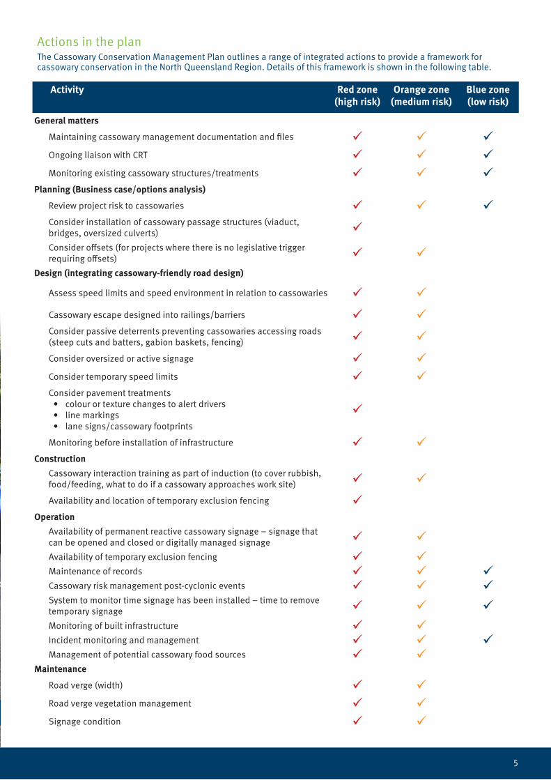
Actions in the planThe Cassowary Conservation Management Plan outlines a range of integrated actions to provide a framework for cassowary conservation in the North Queensland Region. Details of this framework is shown in the following table.
Activity Red zone(high risk)
Orange zone(medium risk)
Blue zone(low risk)
General matters
Maintaining cassowary management documentation and files Ongoing liaison with CRT Monitoring existing cassowary structures/treatments
Planning (Business case/options analysis)
Review project risk to cassowaries Consider installation of cassowary passage structures (viaduct, bridges, oversized culverts) Consider offsets (for projects where there is no legislative trigger requiring offsets)
Design (integrating cassowary-friendly road design)
Assess speed limits and speed environment in relation to cassowaries
Cassowary escape designed into railings/barriers Consider passive deterrents preventing cassowaries accessing roads (steep cuts and batters, gabion baskets, fencing)
Consider oversized or active signage Consider temporary speed limits Consider pavement treatments
• colour or texture changes to alert drivers• line markings• lane signs/cassowary footprints
Monitoring before installation of infrastructure Construction
Cassowary interaction training as part of induction (to cover rubbish, food/feeding, what to do if a cassowary approaches work site)
Availability and location of temporary exclusion fencing Operation
Availability of permanent reactive cassowary signage – signage that can be opened and closed or digitally managed signage Availability of temporary exclusion fencing Maintenance of records Cassowary risk management post-cyclonic events System to monitor time signage has been installed – time to remove temporary signage Monitoring of built infrastructure Incident monitoring and management Management of potential cassowary food sources
Maintenance
Road verge (width) Road verge vegetation management Signage condition

6
Plan implementationImplementation of the Cassowary Conservation Management Plan is focused on updating and the continual review and revision of TMR processes to ensure cassowaries are considered in all project-related activities.This plan will also be used internally to guide all related TMR activities.
Reviewing the plan The Cassowary Conservation Management Plan will be reviewed and checked for consistency and updated as required. At a minimum, a full review will be undertaken every three (3) years. Importantly, the plan is a living document and will be updated as new information, technology and processes are available. Specifically, the following areas will be addressed:
• zone mapping – updated based on new information from the DES cassowary incident database
• management matrix – to accommodate current project management
• the inclusion of new and emerging technologies and initiatives
• initiatives – to be informed by assessment of monitoring data.
Image: Cassowaries on the road in Mission Beach. © State of Queensland (Department of Transport and Main Roads).