Faculty of Engineering Course Descriptions – Aschaffenburg UAS

How we build reality
Effi cient Geometric Documentation of Buildings: Castle Schloss Johannisburg, AschaffenburgCase Study
Z+F is one of the world’s leading manufacturers in the fi eld of non-contact laser measurement technology. Due to years of research, development and numerous successful engineering projects, Z+F is the forerunner in this fi eld with a wealth of knowledge, experience and success.
When it comes to implementing future developments Z+F has always encouraged innovative thinking and open-minds. Our loyal and long-standing customers appreciate our continual innovations, support and the services we provide.
Company Overview
This case study was realised in cooperation with FPK Engineering Company and technet GmbH.
32
FPK Engineering Company
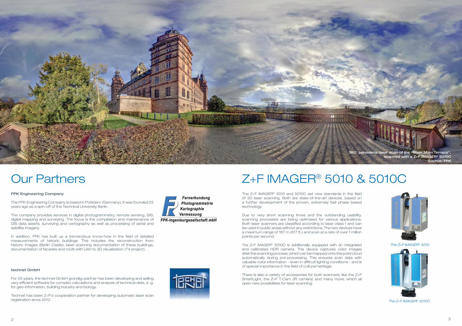
The FPK Engineering Company is based in Potsdam (Germany); it was founded 25 years ago as a spin-off of the Technical University Berlin.
The company provides services in digital photogrammetry, remote sensing, GIS,digital mapping and surveying. The focus is the compilation and maintenance of GIS data assets, surveying and cartography as well as processing of aerial and satellite imagery.
In addition, FPK has built up a tremendous know-how in the fi eld of detailed measurements of historic buildings: This includes the reconstruction from historic images (Berlin Castle), laser scanning documentation of these buildings, documentation of facades and roofs with UAV to 3D visualization (T4 project).
technet GmbH
For 25 years, the technet GmbH gründig+partner has been developing and selling very effi cient software for complex calculations and analysis of technical data, e. g. for geo-information, building industry and biology.
Technet has been Z+F‘s cooperation partner for developing automatic laser scan registration since 2012.
The Z+F IMAGER® 5010
The Z+F IMAGER® 5010 and 5010C set new standards in the fi eld of 3D laser scanning. Both are state-of-the-art devices, based on a further development of the proven, extremely fast phase based technology.
Due to very short scanning times and the outstanding usability, scanning processes are being optimized for various applications. Both laser scanners are classifi ed according to laser class 1 and can be used in public areas without any restrictions. The two devices have a maximum range of 187 m (617 ft.) and scan at a rate of over 1 million points per second.
The Z+F IMAGER® 5010C is additionally equipped with an integrated and calibrated HDR camera. The device captures color images after the scanning process, which can be mapped onto the point cloud automatically during pre-processing. This ensures scan data withvaluable color information - even in difficult lighting conditions - and is of special importance in the field of cultural heritage.
There is also a variety of accessories for both scanners, like the Z+F SmartLight, the Z+F T-Cam (IR camera) and many more, which all open new possibilities for laser scanning.
Z+F IMAGER® 5010 & 5010C Our Partners
The Z+F IMAGER® 5010C
360° panorama laser scan of the “River Main Terrace“, scanned with a Z+F IMAGER® 5010C
Source: FPK
54
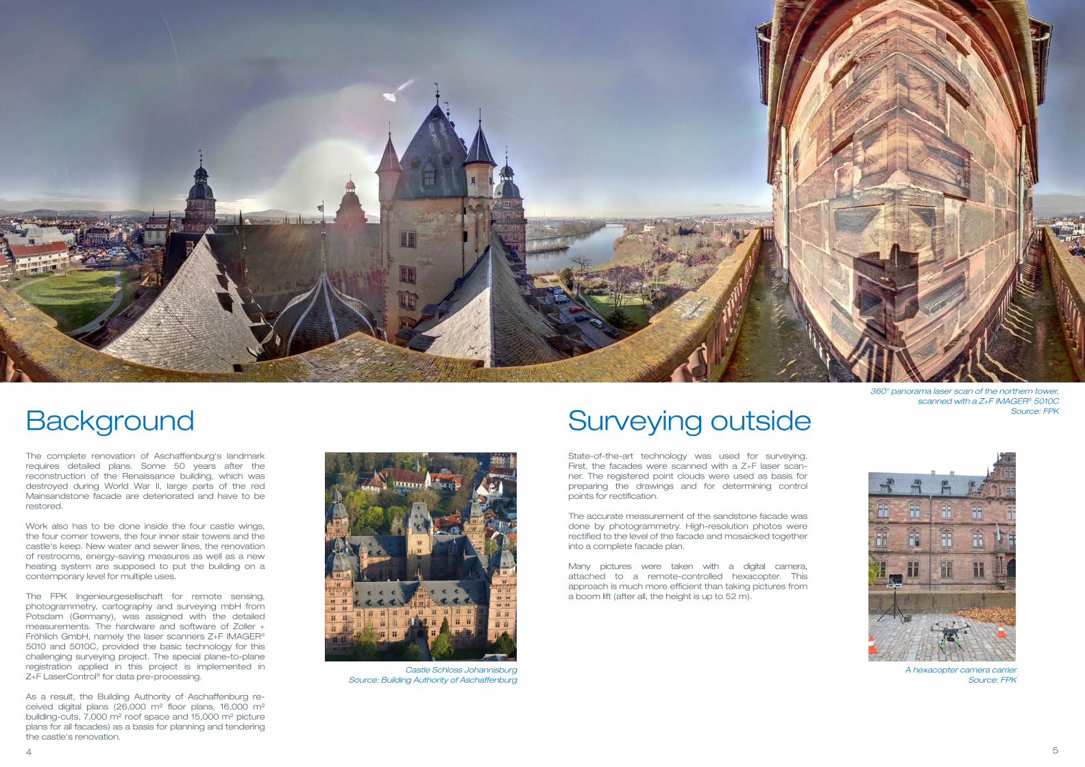
BackgroundThe complete renovation of Aschaffenburg‘s landmark requires detailed plans. Some 50 years after the reconstruction of the Renaissance building, which was destroyed during World War II, large parts of the red Mainsandstone facade are deteriorated and have to be restored.
Work also has to be done inside the four castle wings, the four corner towers, the four inner stair towers and the castle‘s keep. New water and sewer lines, the renovation of restrooms, energy-saving measures as well as a new heating system are supposed to put the building on a contemporary level for multiple uses.
The FPK Ingenieurgesellschaft for remote sensing, photogrammetry, cartography and surveying mbH from Potsdam (Germany), was assigned with the detailed measurements. The hardware and software of Zoller + Fröhlich GmbH, namely the laser scanners Z+F IMAGER® 5010 and 5010C, provided the basic technology for this challenging surveying project. The special plane-to-plane registration applied in this project is implemented in Z+F LaserControl® for data pre-processing.
As a result, the Building Authority of Aschaffenburg re- ceived digital plans (26,000 m² floor plans, 16,000 m² building-cuts, 7,000 m² roof space and 15,000 m² picture plans for all facades) as a basis for planning and tendering the castle‘s renovation.
A hexacopter camera carrierSource: FPK
State-of-the-art technology was used for surveying. First, the facades were scanned with a Z+F laser scan-ner. The registered point clouds were used as basis for preparing the drawings and for determining control points for rectification.
The accurate measurement of the sandstone facade was done by photogrammetry. High-resolution photos were rectified to the level of the facade and mosaicked together into a complete facade plan.
Many pictures were taken with a digital camera, attached to a remote-controlled hexacopter. This approach is much more efficient than taking pictures from a boom lift (after all, the height is up to 52 m).
Surveying outside
Castle Schloss Johannisburg Source: Building Authority of Aschaffenburg
360° panorama laser scan of the northern tower, scanned with a Z+F IMAGER® 5010C
Source: FPK

76
Modern technology was also used for surveying the nearly 370 rooms on 9 floors. The laser scanner Z+F IMAGER® 5010C just needs approximately 3 ½ minutes for each position, due to its high measurement rate of up to 1 million points per second. This was of great importance for the daily routines at the castle, since they had to be interrupted only briefly in some areas for taking the measurements.
More than 1,000 positions were necessary to document the entire Castle Johannisburg. Each individual scan gen-erates a 360° point cloud with its own local coordinate system. To calculate plans and sections through the entire building, the individual scans had to be combined into one overall model. This process is known as “registration.“
Surveying inside Registration methodsFor registration purposes, artificial control points are usually distributed all over the object in a way, that they are in the overlapping region of adjacent scans and can be identified. With software from Z+F (Laser-Control® version 8.5) this can be done automatically, due to the highly developed image processing routines. The transformation parameters are then determined with identical (so-called „homologous“) points in multiple scans. At least 4 points for each scan are required for the calculation of these parameters.
The establishment of signalised control points can be time consum- ing and also extremely difficult for interior rooms and especially high facades, unless only ground based targets are used.
For these reasons, Rüdiger Tauch, CEO of FPK, decided to use the method described below. In cooperation with technet GmbH, Z+F provided the plane-to-plane module SCANTRA for targetless registration.
Laser scan (point cloud) in the attic(JPG-picture, generated with Z+F LaserControl®)
Source: FPK
360° panorama laser scan of an electoral living room, scanned with a Z+F IMAGER® 5010C
Source: FPK
98
For using SCANTRA, it is not necessary to place signalised control points at the scene. Instead, the registration pa-rameters are derived directly from the point cloud of the scans. This reduces the effort involved during surveying. In addition, the methodology results in a signifi cant increase in accuracy.
Plane - Detection
The software automatically extracts planes from the point cloud of each scan. Experience shows, that this generates hundreds of different planes with various expansion dimensions. As these planes are determined by a large number of points, they are more accurate than each individual scan point. Identical planes between two overlapping scans are used to determine the mutual orientation of these scans.
Plane - Matching
By matching planes, it is possible to align two scans with highest accuracy. Compared to a point-based orienta-tion with targets, the entire overlapping area is used as a source of information, so no extrapolation effects do arise.
Plane-to-Plane Registration (SCANTRA) Bundle adjustment
A bundle adjustment process is used to transfer the local pairwise transformation parameters into a global, tension-free system. Overdeterminations and ring closures are factored in this step as well, and optionally coordinates of a superior coordinate system are being processed.
The spatial conditions of Castle Johannisburg also allowed a ring closure for each level. Only for combining the levels, 8 to 10 surveyed targets were additionally used per fl oor. These were processed together with the transformation parameters during bundle adjustment. The integration of SCANTRA into Z+F LaserControl® guarantees a continuous workfl ow.
Integration of targets
Should signalised control points be required in a project, these can be automatically detected with the new Z+F auto paper target module. The coordinates of the targets are then automatically linked and taken into the bundle adjustment in SCANTRA.
Plane-Detection (plane display with Scantra)Source: FPK
Bundle adjustment (resulting graph, Z+F LaserControl®)
Source: FPK
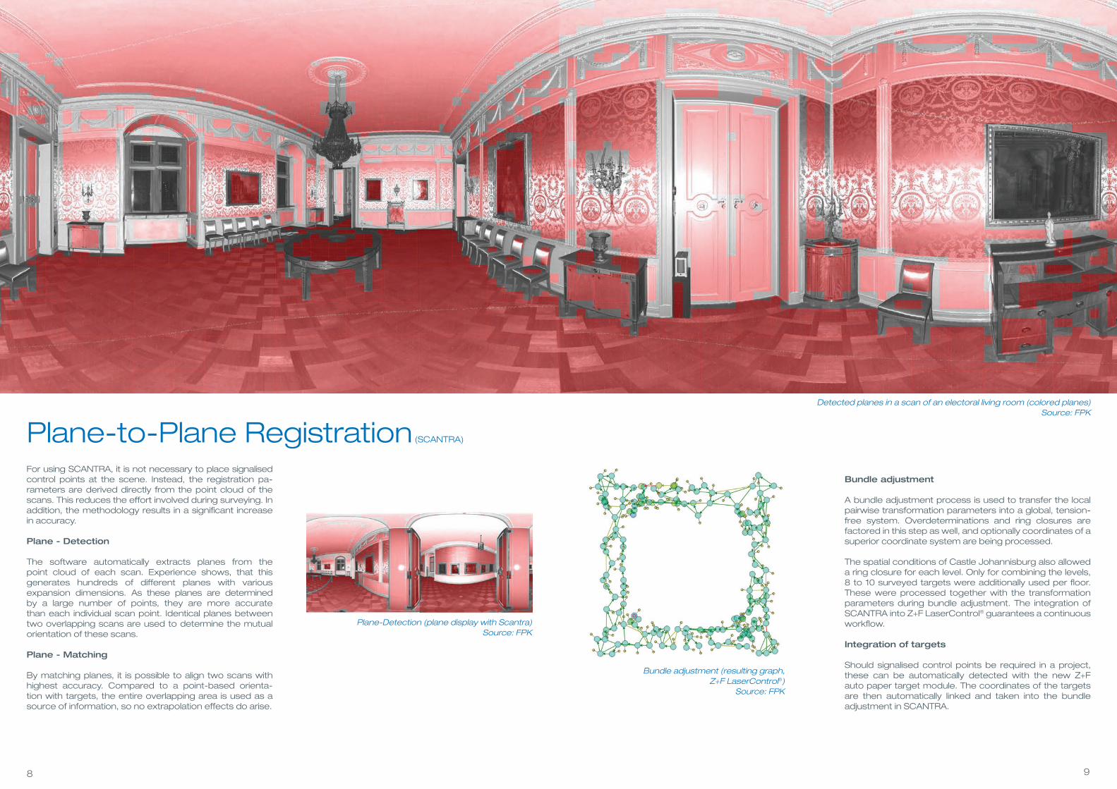
Detected planes in a scan of an electoral living room (colored planes) Source: FPK

1110
Results
Vertical cross section through the “River Main Wing“ of Castle Schloss Johannisburg Source: FPK
At last, the customer was provided with fl oor plans, cross sections and facade plans. They are derived from a co-herent data set with consistent accuracies. Laser scanning was the technically most advanced aspect of this project.
In addition, the utilisation of the plane-to-plane module in Z+F LaserControl® led to signifi cant time saving during measurements and registration, since this methodology accepts to reduce the number of control points to a large extent.
The geometric registration via planes resulted in a signifi cant increase of accuracy, when compared to registrations exclusively based on signalised control points.
Facade plan of the “River Main Wing“ (Original scale 1:20) Source: FPK
Example of a 2D fl oor plan of Castle Schloss JohannisburgSource: FPK

Head offi ce – Germany
Zoller + Fröhlich GmbHSimoniusstrasse 2288239 Wangen im AllgäuGermanyPhone: +49 7522 9308-0Fax: +49 7522 [email protected]
Subsidiary – UK
ZF UK Laser Limited9 Avocado CourtCommerce WayTrafford ParkManchester M17 1HWGreat BritainPhone: +44 161 8717 050Fax: +44 161 3125 [email protected]
Subsidiary – USA
Z+F USA, Inc.700 Old Pond RoadSuite 606Bridgeville, PA 15017USAPhone: +1 412 257 8575Fax: +1 412 257 [email protected]
12/2
014