Caribbean Institute for Meteorology and Hydrology …€¦ · · 2016-05-16Caribbean Institute...
22
Caribbean Institute for Meteorology and Hydrology Husbands, St. James, Barbados Kathy-Ann Caesar RA IV HURRICANE COMMITTEE THIRTY-EIGHTH SESSION SAN JUAN, PUERTO RICO UNITED STATES OF AMERICA 23 TO 26 APRIL 2016
Transcript of Caribbean Institute for Meteorology and Hydrology …€¦ · · 2016-05-16Caribbean Institute...
Caribbean Institute for Meteorology and HydrologyHusbands, St. James, Barbados
Kathy-Ann Caesar
RA IV HURRICANE COMMITTEE
THIRTY-EIGHTH SESSION
SAN JUAN, PUERTO RICO
UNITED STATES OF AMERICA
23 TO 26 APRIL 2016

� The Caribbean DEWETRA Platform –� a real-time data and information integrated system for
hydro-meteorological risk forecasting and disaster risk mitigation.
� It allows for the combination of data, forecast tools, procedures and expertise;
� It provides decision makers with high resolution and up-to-date information of the expected and observed risk and vulnerability.

� WRF Version 3.6.1� ARW-core
� Two runs with different Microphysics options � Run1 – WRF Single-Moment 6-class scheme
� Run2 – New Thompson et al. scheme
� Grell-Freitas Cumulus scheme on domain 1 only
� RRTMG for both longwave and shortwave radiation
� Simulations initialized from GFS 0.5° X 0.5° forecast � Model resolution 12 km (domain 1) and 4 km (domain 2)
� Initialized daily at 00Z, 06Z, 12Z and 18Z
� 48-hr forecast

Tropical Storm Erika - the WRF-ARW model produced a quantitative precipitation forecast (QPF) which mirrored the observed localized rainfall experienced as the storm affected the island of Dominica.
Hurricane Joaquin – The model produce similar QPF results however the WRF-ARW outputs demonstrated it was capable of “correctly” predicting the storm track as it headed towards the open Atlantic Ocean.

� Erika began as a tropical wave on Friday, August 21 midway between the West Coast of Africa and the Cape Verde Islands.
� The wave tracked westward across the tropical mid Atlantic where it intensified to become a tropical storm, the fifth of the season, Tropical Storm Erika, on the evening of August 24th.
� Early in its development Erika had to contend with very dry air to the north of its path.
� The eye was exposed early in the storm lifecycle, with weak tropical force winds to the north and heavy cloud mass and rainfall to the south.

TS Erika entered the northeast Caribbean
early on the morning of August 27th as it
passed through the Leeward Islands
between Guadeloupe and Antigua.
Fortunately, due to the effects of strong
wind shear, which kept the storm from
strengthening.
Unfortunately, it did not diminish the
rainfall which massed to the south of the
system.
Martinique Radar loop displays the passage
of Erika across the Leeward Islands.
Heavy rainfall for 1000 UTC to 1500 UTC
over produce over 12 inches of rainfall
resulting in devastating floods
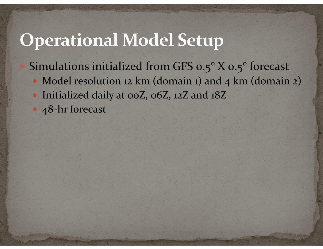
CIMH WRF 4km projected 24 hour rainfall accumulations (Updated data available from CIMH website)
24 hours QPE for the period 27 august 2015 0000UTC – 28 august 2015 0000UTC (upper panel)
compared with 24 hours QPF provided by 4 km WRF-ARW over the same temporal period.
http://www.cimh.edu.bb/

Landslide hazard map for Dominica showing watersheds and
location of intakes
WRF 4km Rainfall Accumulation 26/08/2015
1200 UTC + 30hrs + watersheds …Highest
rainfall predicted for central and southern
areas

Examples of measurements transmitted from stations in Dominica to CIMH in near real-time
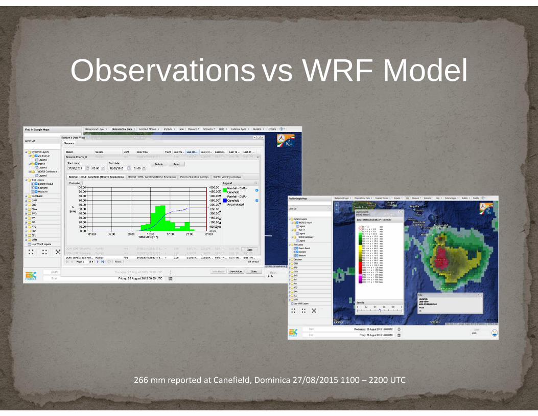
266 mm reported at Canefield, Dominica 27/08/2015 1100 – 2200 UTC
Observations vs WRF Model

� Hurricane Joaquin was an Atlantic basin active tropical cyclone (as per of October 6 2015) that severely impacted large parts of the Bahamas and recently affected Bermuda.
� Hurricane warnings were raised across much of the Bahamas on September 30 2015, as the hurricane threatened the country. Battering the nation's southern islands for over two days, Joaquin caused extensive devastation; Acklins, Crooked Island, Long Island, Rum Cay and San Salvador Island sustained the worst damage.
Hurricane Joaquin
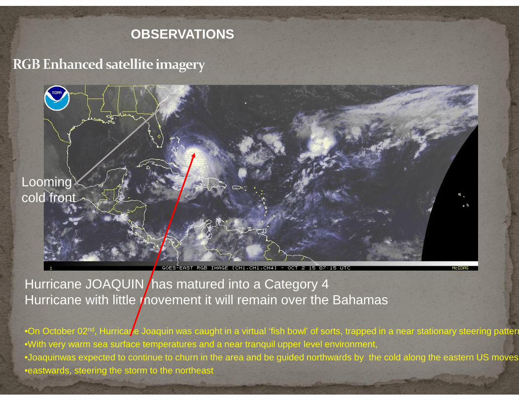
Hurricane JOAQUIN has matured into a Category 4Hurricane with little movement it will remain over the Bahamas
•On October 02nd, Hurricane Joaquin was caught in a virtual ‘fish bowl’ of sorts, trapped in a near stationary steering pattern. •With very warm sea surface temperatures and a near tranquil upper level environment, •Joaquinwas expected to continue to churn in the area and be guided northwards by the cold along the eastern US moves •eastwards, steering the storm to the northeast
OBSERVATIONS
Looming cold front

Early Projections
CIMH WRF 4km projected rainfall accumulation02/10/2015 0000 – 04/10/2015 0000 UTC WRF model accumulation suggest > 100 - 600mm for 48 hour period shown
• The CIMH WRF 4 km WRF
model Rainfall out
projected over 600 mm of
rainfall.
• But the 48 hour
projection showed the
accumulation was more
to the Northeast rather
than towards the NorthNHC Atlantic - Caribbean Sea - Gulf of
Mexico tropical weather outlook (1
october 2015).

� Interesting enough IFS-ECMWF model projections were consistenly forecasting that Joaquin would have headed off to sea, as indeed it has happened.
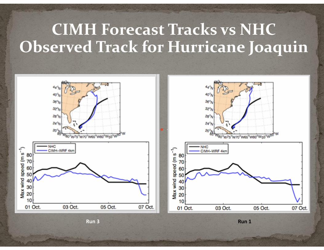
CIMH Forecast Tracks vs NHC Observed Track for Hurricane Joaquin
Run 3 Run 1
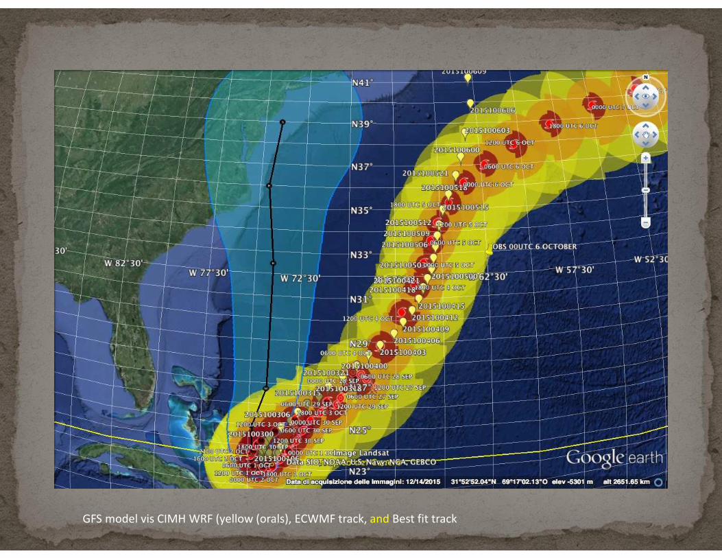
GFS model vis CIMH WRF (yellow (orals), ECWMF track, and Best fit track

� The reason for the success appears to be in the use of the nested grid process and the high resolution of the model.
� CIMH continues to experiment with these approaches and intends to increase its efforts to improve on these products for the betterment of the Region.
� All Services are encouraged to make use of DEWETRA and the Model Out Puts
� The 4km outputs are available here:http://affp.cimh.edu.bb/0000z-wrf-disaggregated-outputs/#output-3
Summary
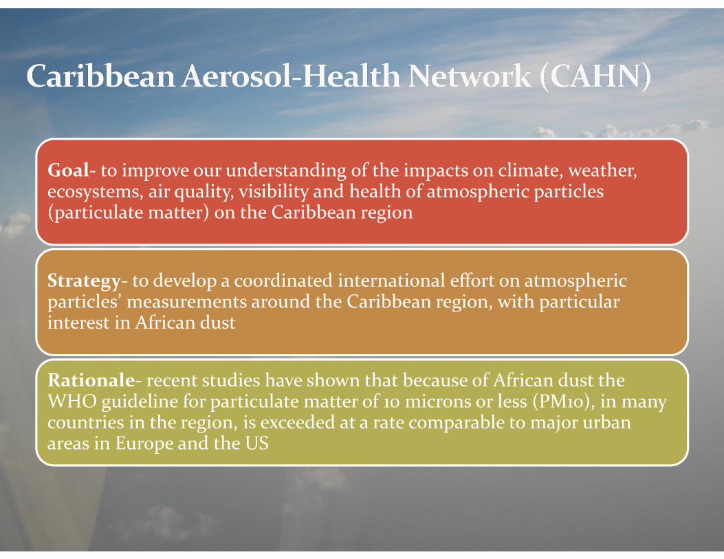
Goal- to improve our understanding of the impacts on climate, weather, ecosystems, air quality, visibility and health of atmospheric particles (particulate matter) on the Caribbean region
Strategy- to develop a coordinated international effort on atmospheric particles’ measurements around the Caribbean region, with particular interest in African dust
Rationale- recent studies have shown that because of African dust the WHO guideline for particulate matter of 10 microns or less (PM10), in many countries in the region, is exceeded at a rate comparable to major urban areas in Europe and the US

� First meeting- April 24-25 2016, San Juan, Puerto Rico� Identify leadership, composition, structure and goals of the
network, � Establish formal network (e.g. via MOUs)� Finalize framework for the educational aspects (e.g., courses,
student internships)� Establish sampling/observation/analysis protocols within the
CAHN, � Discuss plans for longer term funding and sustainability of CAHN � Identify small group to work on a larger proposal that could
provide funding on a long-term basis � Discuss aspects of infrastructure and data management (e.g.,
website, database for all observations) � Plan for periodic meetings of CAHN partners � Write a perspective piece on the status of atmospheric particle
measurements in the region that could be published in a peer-reviewed journal

Disclaimer� CIMH is providing special weather interpretation of the
current and forecasted tropical weather affecting theCaribbean region.
� CIMH is not an official forecasting agency
Caribbean Institute for Meteorology and Hydrologywww.cimh.edu.bb
Facebook: www.facebook.com/CIMHbbYouTube: www.youtube.com/user/CIMHTV
Twitter: @CIMHbb
Thank YouQuestions


![Farm decisions under dynamic meteorology and the curse of ... · (e.g.Rivington et al.[2007]). Agricultural economics, irrigation engineering, hydrology, meteorology, soil sciences,](https://static.fdocuments.in/doc/165x107/5fbea9ef8f19652dd361d1d9/farm-decisions-under-dynamic-meteorology-and-the-curse-of-egrivington-et.jpg)