Soil Investigation - California Department of Water Resources

San Joaquin SeriesCalifornia State Soil
Chip Clark/Smithsonian Institution
Soil Science Society of America
IntroductionMany states have a designated state bird, flower, fossil, mineral, etc. In California the state bird is the California Valley Quail, the state flower is the Golden Poppy, the state fossil is the Saber-toothed Cat, and the state mineral is Native Gold. Many states also have a state soil – one that has significance or is important to the state. The San Joaquin is the official state soil of California. Let’s explore how the San Joaquin is important to California and even the entire world.
HistoryThe San Joaquin soil was initially documented and officially established in California in 1900 and therefore is the oldest, continuously recognized soil series within the state. The process of establishing the San Joaquin as the official state soil in California began with the Professional Soil Scientists Association of California (PSSAC).
The catalyst for further action came when Alex Lehman, a science teacher from Madera, CA vis-ited the USDA, Natural Resources Conservation Service soil survey offices in Madera and Han-ford, CA and proposed working together. Discussions with soil scientists in those offices centered around a vision for working with students and the public for conservation education that could be accomplished through the process of establishment of an official state soil. The project, titled “Proposing a California State Soil—Preserving a Legacy and a Commitment to Future Genera-tions” was launched.
Students at Martin Luther King, Jr. Middle School in Madera, CA learned about and incorporated science, math, English, social studies, and history with conservation education. The lawmaking process was discussed in social studies classes; rough-draft bills as well as poems about soil were written in English classes; displays for the science fair were completed in science and art classes; and an official state soil song was written in music classes.
Students then developed legislative proposals (over 180 were developed) for a state soil and the top 14 were chosen for students to present before Sacramento politicians at the state capitol (Figure 1).
Fig. 1 Students present the proposal to make the San Joaquin the official state soil to the California State Senate. Credit: Madera Tribune

2
Fig. 3 San Joaquin soil series is the official state soil of California. Credit: Smithsonian Institution.
Fig. 2. Soil Profile of a San Joaquin soil illustrating horizons and horizon boundaries. Credit: USDA-NRCS.
There were a number of events and challenges that occurred along this road to success. Students presented their proposals to two different committees in the State Senate and finally to the California Assembly. Their perseverance had a significant impact on influential California Assembly members. Valerie Brown, the Chair of the Assembly Governmental Organization Committee, said: “I’m going to tell you that never in the history of my time here in the legislature, which has been five years, have you ever held members to such attention, and it will truly go down in his-tory as one of the finer moments for this legislature. We actually learned something.”
The San Joaquin Soil Series became the official state soil of Cali-fornia on August 20, 1997. It was the culmination of the efforts by students and teachers, natural resources professionals, the PSSAC, state legislators, and various state universities.
What is the San Joaquin Soil?The first characteristic in a San Joaquin soil that people notice is a distinctive soil horizon (layer) known as a duripan to soil scien-tists and generally as “hardpan” to many people. It is extremely hard and it can be chipped with mechanical means or through use of a pick or very strong, heavy shovel. However, there is much more to the San Joaquin soil than just the duripan.
Every soil can be separated into three separate particle size frac-tions called sand, silt, and clay, which makes up the soil texture. In addition, the arrangement of soil horizons can tell you a lot about the age of a soil and how it developed over time. Some common horizon designations are A, E, B, and C or combinations of those.
Typically, San Joaquin soils have a brown to reddish brown sur-face or surface soil horizon with a loam (a combination of sand, silt, and clay) texture that has an accumulation of organic matter. The next underlying horizon is similar in soil texture to the sur-
face horizons; however it does not have an accumulation of or-ganic matter. Iron oxides released in this horizon are not masked so much by the organic matter and impart a redder hue to the soil when moist. This horizon rests on a brown or reddish brown clay or clay loam horizon that has a distinctive prismatic structure (soil broken up into pillar like structures) with cracks between the prisms. This horizon, with a dramatic increase in clay which restricts root and water penetration, is about 38 to 76 cm (15 to 30 inches) from the surface of the soil.
Finally, the fourth horizon is the brown to reddish brown silica cemented duripan. The duripan has an abrupt upper boundary at a depth of 50 to 101 cm (20 to 40 inches) and is impervious to roots and water. The duripan often continues to a depth of 152 cm (60 inches) or more. (Figure 2)
Where to dig a San JoaquinYes, you can dig a soil. It is called a soil pit and it shows you the soil profile. The different horizontal layers of the soil are called soil horizons. This does not mean that other types of soil cannot be found there but that the San Joaquin is the most common. San Joaquin soils now occupy old, extensive, nearly level land surfaces on the east side of the San Joaquin and lower Sacramento Val-leys that are part of California’s Great Central Valley (Figure 3). Nearly 438,000 acres of this soil have been identified and mapped in this part of California.
Importance of the San JoaquinSan Joaquin was chosen as the California State Soil because of its interesting soil characteristics, had agricultural significance, had extensive distribution, had a soil name recognizably Califor-nian, and had its typical location in California. The gross value of agricultural production in counties that are located in the San Joaquin Valley of California exceeded 39 billion dollars in 2014. San Joaquin soils occupy a niche along the east side of the San Joaquin and lower Sacramento Valleys as a small but important part of this huge California agricultural base. San Joaquin soil is not the best soil for production of crops, however with proper management, this soil has produced many billions of dollars of agricultural wealth for the state’s economy.
3
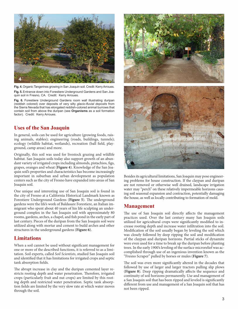
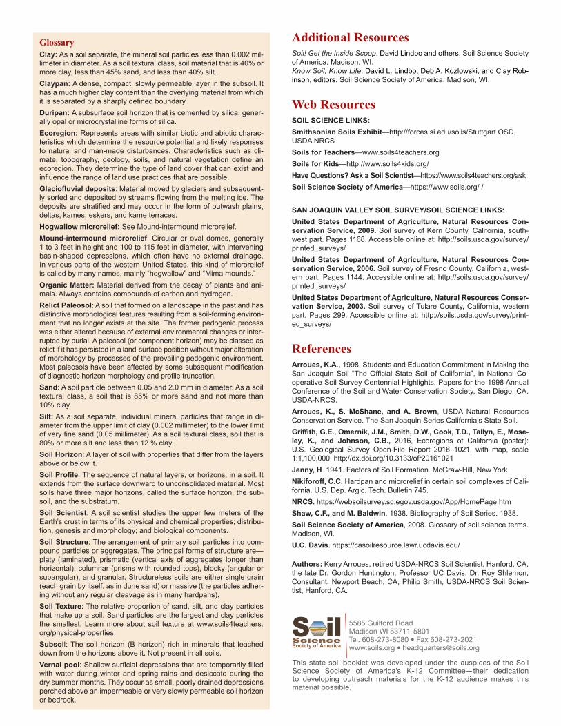
Fig. 4. Organic Tangerines growing in San Joaquin soil. Credit: Kerry Arroues.Fig. 5. Entrance down into Forestiere Underground Gardens and San Joa-quin soil in Fresno, CA. Credit: Kerry Arroues.Fig. 6. Forestiere Underground Gardens room wall illustrating duripan (reddish colored) over deposits of very silty glacio-fluvial deposits from the Sierra Nevada that has elongated reddish-colored animal burrows that contain soil from above the duripan (see Organisms as a soil formation factor). Credit: Kerry Arroues.
Uses of the San JoaquinIn general, soils can be used for agriculture (growing foods, rais-ing animals, stables); engineering (roads, buildings, tunnels); ecology (wildlife habitat, wetlands), recreation (ball field, play-ground, camp areas) and more.
Originally, this soil was used for livestock grazing and wildlife habitat. San Joaquin soils today also support growth of an abun-dant variety of irrigated crops including almonds, pistachios, figs, grapes, oranges and wheat (Figure 4). Knowledge of the San Joa-quin soil’s properties and characteristics has become increasingly important in suburban and urban development as population centers such as the city of Fresno have expanded into areas of San Joaquin soil.
One unique and interesting use of San Joaquin soil is found in the city of Fresno at a California Historical Landmark known as Forestiere Underground Gardens (Figure 5). The underground gardens were the life’s work of Baldasare Forestiere, an Italian im-migrant who spent about 40 years of his life sculpting an under-ground complex in the San Joaquin soil with approximately 80 rooms, gardens, arches, a chapel, and fish pond in the early part of last century. Pieces of the duripan from the San Joaquin soil were utilized along with mortar and cement to build arches and other structures in the underground gardens (Figure 6).
LimitationsWhen a soil cannot be used without significant management for one or more of the described functions, it is referred to as a limi-tation. Soil experts, called Soil Scientists, studied San Joaquin soil and identified that it has limitations for irrigated crops and septic tank absorption fields.
The abrupt increase in clay and the duripan cemented layer re-stricts rooting depth and water penetration. Therefore, irrigated crops (particularly fruit and nut crops) are limited by this root-ing depth and restricted water penetration. Septic tank absorp-tion fields are limited by the very slow rate at which water moves through the soil.
4 5
6
Besides its agricultural limitations, San Joaquin may pose engineer-ing problems for house construction. If the claypan and duripan are not removed or otherwise well drained, landscape irrigation water may “perch” on these relatively impermeable horizons caus-ing soil seasonal expansion and contraction, potentially damaging the house, as well as locally contributing to formation of mold.
ManagementThe use of San Joaquin soil directly affects the management practices used. Over the last century many San Joaquin soils utilized for agricultural crops were significantly modified to in-crease rooting depth and increase water infiltration into the soil. Modification of the soil usually began by leveling the soil which was closely followed by deep ripping the soil and modification of the claypan and duripan horizons. Partial sticks of dynamite were even used for a time to break up the duripan before planting trees. In the early 1900’s leveling of the surface microrelief was ac-complished through use of an ingenious invention known as the “Fresno Scraper” pulled by horses or mules (Figure 7).
The soil was even more significantly altered in the decades that followed by use of larger and larger tractors pulling slip plows (Figure 8). Deep ripping dramatically affects the sequence and continuity of soil horizons permanently. Use and management of a San Joaquin soil that has been ripped and leveled is significantly different from use and management of a San Joaquin soil that has not been ripped.

Modification of the soil accomplished the intended purpose by increasing the root zone and water infiltration into the soil. It also permanently disrupted the natural ecology of these areas by changing the hydrology and ponding characteristics and the sequence and continuity of soil horizons permanently. This is an excellent example of the affect that organisms (humans) can have on soil formation. In recent decades it has been recognized that natural, relatively unmodified environments with unique features have value and can be preserved in some areas. These preserves and conservancies have allowed future generations to see what past landscapes of San Joaquin soil looked like before they were modified.
San Joaquin Soil FormationBefore there was soil there were rocks and in between “ClORPT.” Without ClORPT, there will be no soil. So what is ClORPT? It stands for the five major factors responsible for forming a soil like the San Joaquin series. It is an abbreviation for Climate, Organisms, Relief, Parent material, and Time. ClORPT is responsible for the development of soil profiles and chemical properties that differentiate soils. So, the characteristics of San Joaquin soil (and all other soils) are determined by the influence of ClORPT. Weathering takes place when environmental processes such as rainfall, freezing and thawing act on rocks causing them to dissolve or fracture and break into pieces. ClORPT then acts on rock pieces, marine sediments and vegetative materials to form soils.
Let’s see what each ClORPT factor means:Climate – Temperature and precipitation influence the rate at which parent materials weather and dead plants and animals decompose. They affect the chemical, physical and biological relationships in the soil. California’s Mediterranean climate of cool, moist winters and dry, warm summers contributes to formation of the San Joaquin soils. The age of the San Joaquin soil is also important (see Time section). We therefore call the San Joaquin soil a relict paleosol; that is, a soil that attained most of its relative profile development under climatic and environmental conditions of the past. Soil formation factors in the San Joaquin soil are presumed to have been cyclic and occurred in response to warming and cooling periods of two previous glacial episodes in the Sierra Nevada over about the last 100,000 years.
4
Fig. 7 Fresno Scraper was utilized to assist movement of large amounts of soil efficiently when leveling the natural microrelief of the landscape. Credit: ASME landmarks program.
Fig. 8 Tractor with slip plow used to fracture, disrupt and modify horizons such as claypans and duripans. Credit: Kerry Arroues.
Organisms – This refers to plants and animal life. In the soil, plant roots spread, animals burrow in, and bacteria break down plant and animal tissue. These and other soil organisms speed up the breakdown of large soil particles into smaller ones. Plants and animals also influence the formation and differentiation of soil horizons. Plants determine the kinds and amounts of organic matter that are added to a soil under normal conditions. Animals breakdown complex compounds into small ones and in so doing add organic matter to soil. We usually see macro biological changes by gophers and ground squirrels, however small animals such as earthworms and ants, and even smaller organisms such as bacteria affect the soil. Gophers and ground squirrels have apparently developed an instinct for settling on the mounds because of greater thick-ness of soft soil above the duripan, better protection from floods, and better position for the observation of their enemies (such as hawks and coyotes). Some mounds are virtually hon-eycombed by tunnels and passages bored by the squirrels.
Relief – Landform position or relief describes the shape of the land (hills and valleys), and the direction it faces which makes a difference in how much sunlight the soil gets and how much water it keeps. Deeper soils usually form at the bottom of the hill rather than at the top because gravity and water move soil particles downhill. San Joaquin soils now occupy old, exten-sive, nearly level land surfaces on the east side of the San Joa-quin and lower Sacramento Valleys. These land surfaces are stream terraces and fan remnants now situated above the pres-ent flood plains and broad alluvial fans that made up the east-ern part of California’s Great Central Valley. Natural, unmodi-fied San Joaquin soil is characterized by mound-intermound microrelief that mantles the broad and extensive, nearly level surface. In California this peculiar microrelief (little relief) is commonly described as “hog wallows.” (Figures 9 and 10)
Parent material (C horizon) – Just like people inherit charac-teristics from their parents, every soil inherits some traits from the material from which it forms. Some parent materials are transported and deposited by glaciers, wind, water, or gravity. San Joaquin soils formed in alluvium that originated from the rocks of the Sierra Nevada mountain range. This alluvium was deposited by many streams (both small and large) that flowed out of the Sierra Nevada and dropped their loads of gravel, sand, silt and clay along the eastern side of the broad Central Valley of California. This alluvium was primarily a mixture of ground up particles of granite along with some schist, quartz-ite and other rocks eroded by glaciers and stream action. His-toric falls of volcanic ash and the deposition of the glacio-flu-

5
vial alluvium from the Sierra Nevada, have also contributed to the unique origin and form of the San Joaquin soils.
Time –All the factors act together over a very long period of time to produce soils. As a result, soils vary in age. The length of time that soil material has been exposed to the soil-form-ing processes makes older soils different from younger soils. Generally, older soils have better defined horizons than young soils. Less time is needed for a soil profile to develop in a hu-mid and warm area with dense vegetative cover than in a cold dry area with sparse plant cover. More time is required for the formation of a well-defined soil profile in soils with fine tex-tured material than in soils with coarse-textured soil material. The San Joaquin soil profile has a number of clues indicating that it is an old soil. The claypan and cemented duripan are strong evidence for a very old soil. The San Joaquin soil occurs on a geologic formation known as the “Riverbank” from its type locality as exposed on the south bank of the Stanislaus River at the town of Riverbank. The upper part of the River-bank, upon which the San Joaquin soil is typical, was prob-ably laid down during a major glacial event in the Sierra Ne-vada, about 130,000 to 180,000 years ago. The San Joaquin soil formed mainly during the following interglacial epoch of rela-tive geomorphic (landscape) stability, about 125,000 to 80,000 years ago.
Ecoregions, Soils and Land Use in CaliforniaCentral California Valley
Flat, intensively farmed plains with long, hot, dry summers and mild winters distinguish the Central California Valley ecoregion from its neighboring ecoregions that are either hilly or mountain-ous, covered with forest or shrub, and generally non-agricultural. Ecoregion 7 (Figure 11) includes the flat valley basins of deep sediments adjacent to the Sacramento and San Joaquin Rivers, as well as the fans and terraces around the edge of the valley. The two major rivers flow from opposite ends of the Central Califor-nia Valley, entering into the Sacramento–San Joaquin River Delta and San Pablo Bay. The region once contained extensive prairies, oak savannas, desert grasslands in the south, riparian woodlands, freshwater marshes, and vernal pools. More than one-half of the region is now in cropland, about three-fourths of which is ir-rigated. Environmental concerns in the region include salinity, ground water overdraft, and subsidence, loss of wildlife and flora habitats, and urban sprawl.
Fig. 9 Unmodified San Joaquin soil landscape with modified and leveled soils under an orange orchard. The Sierra Nevada Mountains rise as high as 4,267 meters (14,000 feet) above the San Joaquin soils. Credit: Edd Russell.
Fig. 11 Detail from Ecoregions of California map. Credit: US-EPA
Fig. 10 Hogwallow microrelief illustrating ponding in depressions between mounds. Credit: Phil Smith, USDA-NRCS.
San Joaquin soils that are mapped on the Northern Terraces (Ecoregion 7a) on the eastern side of the lower Sacramento Val-ley occur on gently sloping to sloping terraces. Vernal pools are in some areas. Streams drain mostly to the Sacramento River, with a few in the south draining to the lower San Joaquin River.
San Joaquin soils that are mapped on the Southern Hardpan Ter-races (Ecoregion 7d) are on very gently sloping terraces along the eastern edge of the San Joaquin Valley. Elevations range from 46 to 152 meters (150 to 500 feet). This ecoregion is warmer and drier than the Northern Terraces ecoregion to the north. Vernal pools are common. Streams drain to the San Joaquin River or the San Joaquin Valley closed basins, such as the Tulare Lake Bed, that was once the largest freshwater lake west of the Great Lakes.
Ecoregion 7
GlossaryClay: As a soil separate, the mineral soil particles less than 0.002 mil-limeter in diameter. As a soil textural class, soil material that is 40% or more clay, less than 45% sand, and less than 40% silt.Claypan: A dense, compact, slowly permeable layer in the subsoil. It has a much higher clay content than the overlying material from which it is separated by a sharply defined boundary.Duripan: A subsurface soil horizon that is cemented by silica, gener-ally opal or microcrystalline forms of silica.Ecoregion: Represents areas with similar biotic and abiotic charac-teristics which determine the resource potential and likely responses to natural and man-made disturbances. Characteristics such as cli-mate, topography, geology, soils, and natural vegetation define an ecoregion. They determine the type of land cover that can exist and influence the range of land use practices that are possible.Glaciofluvial deposits: Material moved by glaciers and subsequent-ly sorted and deposited by streams flowing from the melting ice. The deposits are stratified and may occur in the form of outwash plains, deltas, kames, eskers, and kame terraces.Hogwallow microrelief: See Mound-intermound microrelief.Mound-intermound microrelief: Circular or oval domes, generally 1 to 3 feet in height and 100 to 115 feet in diameter, with intervening basin-shaped depressions, which often have no external drainage. In various parts of the western United States, this kind of microrelief is called by many names, mainly “hogwallow” and “Mima mounds.”Organic Matter: Material derived from the decay of plants and ani-mals. Always contains compounds of carbon and hydrogen.Relict Paleosol: A soil that formed on a landscape in the past and has distinctive morphological features resulting from a soil-forming environ-ment that no longer exists at the site. The former pedogenic process was either altered because of external environmental changes or inter-rupted by burial. A paleosol (or component horizon) may be classed as relict if it has persisted in a land-surface position without major alteration of morphology by processes of the prevailing pedogenic environment. Most paleosols have been affected by some subsequent modification of diagnostic horizon morphology and profile truncation.Sand: A soil particle between 0.05 and 2.0 mm in diameter. As a soil textural class, a soil that is 85% or more sand and not more than 10% clay. Silt: As a soil separate, individual mineral particles that range in di-ameter from the upper limit of clay (0.002 millimeter) to the lower limit of very fine sand (0.05 millimeter). As a soil textural class, soil that is 80% or more silt and less than 12 % clay.Soil Horizon: A layer of soil with properties that differ from the layers above or below it.Soil Profile: The sequence of natural layers, or horizons, in a soil. It extends from the surface downward to unconsolidated material. Most soils have three major horizons, called the surface horizon, the sub-soil, and the substratum.Soil Scientist: A soil scientist studies the upper few meters of the Earth’s crust in terms of its physical and chemical properties; distribu-tion, genesis and morphology; and biological components.Soil Structure: The arrangement of primary soil particles into com-pound particles or aggregates. The principal forms of structure are—platy (laminated), prismatic (vertical axis of aggregates longer than horizontal), columnar (prisms with rounded tops), blocky (angular or subangular), and granular. Structureless soils are either single grain (each grain by itself, as in dune sand) or massive (the particles adher-ing without any regular cleavage as in many hardpans).Soil Texture: The relative proportion of sand, silt, and clay particles that make up a soil. Sand particles are the largest and clay particles the smallest. Learn more about soil texture at www.soils4teachers.org/physical-propertiesSubsoil: The soil horizon (B horizon) rich in minerals that leached down from the horizons above it. Not present in all soils.Vernal pool: Shallow surficial depressions that are temporarily filled with water during winter and spring rains and desiccate during the dry summer months. They occur as small, poorly drained depressions perched above an impermeable or very slowly permeable soil horizon or bedrock.
Additional ResourcesSoil! Get the Inside Scoop. David Lindbo and others. Soil Science Society of America, Madison, WI.Know Soil, Know Life. David L. Lindbo, Deb A. Kozlowski, and Clay Rob-inson, editors. Soil Science Society of America, Madison, WI.
Web Resources SOIL SCIENCE LINKS:Smithsonian Soils Exhibit—http://forces.si.edu/soils/Stuttgart OSD, USDA NRCSSoils for Teachers—www.soils4teachers.orgSoils for Kids—http://www.soils4kids.org/Have Questions? Ask a Soil Scientist—https://www.soils4teachers.org/askSoil Science Society of America—https://www.soils.org/ /
SAN JOAQUIN VALLEY SOIL SURVEY/SOIL SCIENCE LINKS:United States Department of Agriculture, Natural Resources Con-servation Service, 2009. Soil survey of Kern County, California, south-west part. Pages 1168. Accessible online at: http://soils.usda.gov/survey/printed_surveys/United States Department of Agriculture, Natural Resources Con-servation Service, 2006. Soil survey of Fresno County, California, west-ern part. Pages 1144. Accessible online at: http://soils.usda.gov/survey/printed_surveys/United States Department of Agriculture, Natural Resources Conser-vation Service, 2003. Soil survey of Tulare County, California, western part. Pages 299. Accessible online at: http://soils.usda.gov/survey/print-ed_surveys/
ReferencesArroues, K.A., 1998. Students and Education Commitment in Making the San Joaquin Soil “The Official State Soil of California”, in National Co-operative Soil Survey Centennial Highlights, Papers for the 1998 Annual Conference of the Soil and Water Conservation Society, San Diego, CA. USDA-NRCS.Arroues, K., S. McShane, and A. Brown, USDA Natural Resources Conservation Service. The San Joaquin Series California’s State Soil.Griffith, G.E., Omernik, J.M., Smith, D.W., Cook, T.D., Tallyn, E., Mose-ley, K., and Johnson, C.B., 2016, Ecoregions of California (poster): U.S. Geological Survey Open-File Report 2016–1021, with map, scale 1:1,100,000, http://dx.doi.org/10.3133/ofr20161021Jenny, H. 1941. Factors of Soil Formation. McGraw-Hill, New York.Nikiforoff, C.C. Hardpan and microrelief in certain soil complexes of Cali-fornia. U.S. Dep. Argic. Tech. Bulletin 745.NRCS. https://websoilsurvey.sc.egov.usda.gov/App/HomePage.htmShaw, C.F., and M. Baldwin, 1938. Bibliography of Soil Series. 1938.Soil Science Society of America, 2008. Glossary of soil science terms. Madison, WI.U.C. Davis. https://casoilresource.lawr.ucdavis.edu/
Authors: Kerry Arroues, retired USDA-NRCS Soil Scientist, Hanford, CA,the late Dr. Gordon Huntington, Professor UC Davis, Dr. Roy Shlemon, Consultant, Newport Beach, CA, Philip Smith, USDA-NRCS Soil Scien-tist, Hanford, CA.
5585 Guilford RoadMadison WI 53711-5801Tel. 608-273-8080 • Fax 608-273-2021www.soils.org • [email protected]
This state soil booklet was developed under the auspices of the Soil Science Society of America’s K-12 Committee—their dedication to developing outreach materials for the K-12 audience makes this material possible.