Appendix Cover Sheets - California Department of Parks … and Trail Change-in-Use Evaluation...
68
Appendix K Road and Trail Change in Use Erosion Vulnerability Study
Transcript of Appendix Cover Sheets - California Department of Parks … and Trail Change-in-Use Evaluation...
Appendix K Road and Trail Change in Use
Erosion Vulnerability Study

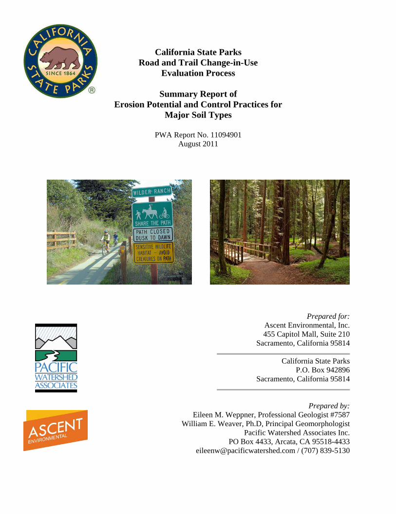
California State Parks Road and Trail Change-in-Use
Evaluation Process
Summary Report of Erosion Potential and Control Practices for
Major Soil Types
PWA Report No. 11094901 August 2011
Prepared for: Ascent Environmental, Inc. 455 Capitol Mall, Suite 210
Sacramento, California 95814
California State Parks P.O. Box 942896
Sacramento, California 95814
Prepared by: Eileen M. Weppner, Professional Geologist #7587
William E. Weaver, Ph.D, Principal Geomorphologist Pacific Watershed Associates Inc.
PO Box 4433, Arcata, CA 95518-4433 [email protected] / (707) 839-5130

Road and Trail Change-in-Use Evaluation Process California State Parks Erosion Potential and Control Practices for Major Soil Types August 2011
i
CONTENTS
1. INTRODUCTION..................................................................................................................... 1
2. LITERATURE REVIEW ........................................................................................................ 1 2.1 TRAIL STUDIES, DECISION FRAMEWORKS, AND OTHER RESEARCH .......... 3
2.11 Recreation Ecology in Trail Studies ............................................................................ 3 2.12 Decision Frameworks ................................................................................................... 3 2.13 Research Approaches ................................................................................................... 5 2.14 Trail “Degradation” Research ..................................................................................... 6
2.2 TRAIL EROSION ............................................................................................................... 7 2.21 Factors affecting trail erosion ...................................................................................... 8
2.211 Environmental factors ............................................................................................ 8 2.212 Management factors ............................................................................................. 12 2.213 Use-related factors ................................................................................................ 16
3. MODELS AND METHODS USED TO EVALUATE SOIL EROSION IMPACTS ....... 30 3.1 ENVIRONMENTAL CRITERIA-BASED MODELS .................................................. 31
3.11 Spatial soil erosion vulnerability models .................................................................. 31 3.111 Revised Universal Soil Loss Equation (RUSLE) ................................................ 31 3.112 Water Erosion Prediction Project – WEPP ........................................................ 33 3.113 Cal Fire Erosion Hazard Rating – EHR ............................................................. 34
3.12 Linear soil erosion vulnerability models ................................................................... 35 3.121 Water Erosion Prediction Project Interface for Roads -WEPP Road ............. 35 3.122 Sediment Model –SEDMODL2 ........................................................................... 36
3.2 ENVIRONMENTAL AND USER-TYPE CRITERIA-BASED DECISION METHODS ...................................................................................................................... 37
3.21 Simple Additive Weighting (SAW)............................................................................ 39 3.22 Weighted Product Model (WPM) .............................................................................. 39 3.23 Technique for Order Preference by Similarity to Ideal Solution (TOPSIS) ......... 40 3.24 Analytical Hierarchy Process (AHP) ........................................................................ 40 3.25 Elimination and Choice Expressing Reality (ELECTRE) ...................................... 41 3.26 Multi-criteria decision method limitations and suitability for the State Parks
PEIR ........................................................................................................................... 42
4. STATE PARKS PEIR ROAD AND TRAIL CHANGE-IN-USE CONCEPTUAL DECISION-MAKING PROCESS .................................................................................... 43
4.1 CONCEPTUAL ROAD AND TRAIL CHANGE-IN-USE DECISION-MAKING PROCESS ........................................................................................................................ 43
4.2 HYPOTHEICAL NUMERIC EXAMPLE OF THE STATE PARKS ROAD AND TRAIL CHANGE-IN-USE SAW DECISION ANALYSIS ........................................ 50
4.3 CONSISTENCY AND TRANSPARENCY OF THE CONCEPTUAL DECISION-ASSISTANCE TOOL WITH STATE PARKS EXISTING ROAD AND TRAIL CHANGE-IN-USE PROCEDURES.............................................................................. 53
5. CONCLUSIONS ..................................................................................................................... 54
6. REFERENCES ........................................................................................................................ 55

Road and Trail Change-in-Use Evaluation Process California State Parks Erosion Potential and Control Practices for Major Soil Types August 2011
1
1. INTRODUCTION In March 2011, Pacific Watershed Associates, Inc. (PWA) was subcontracted by Ascent Environmental, Inc. to conduct a technical study pertaining to road and trail change-in-use impacts on soil erosion. The technical study was developed to address key issues related to erosion that are critical to the development of the California Department of Parks and Recreation (State Parks) Road and Trail Change-In-Use Evaluation Process Program Environmental Impact Report (PEIR). The main goal of the erosion study is to develop a framework for a practical analytical methodology that can be employed to evaluate existing and potential impacts on soil erosion in the PEIR and to assist State Parks staff making informed decisions regarding the change-in-use proposals for roads or trails. This methodology approach employs existing models, hybrid model(s), method(s), and other practical decision-making approaches that can be used by State Parks staff when reviewing change-in-use proposals. This technical study involves: 1) a rigorous review of available relevant literature pertaining to the evaluation of soil erosion on trails, including the review of trail condition assessment techniques, and environmental and user defined processes that effect soil erosion; (2) evaluation of the suitability and appropriateness of erosion hazard models and decision framework tools that would help State Parks staff make informed decisions about whether proposed trail uses will have impacts on soil erosion; (3) development of a systematic and rational framework for a State Parks road and trail change-in-use decision-assistance tool based on site characteristics (topographic characteristics, soil types, trail features and trail use variables), sound science, and supported by sound technical literature; (4) evaluation of the State Parks trail evaluation procedures, including the Change-In-Use Survey Form, Trail Log, and California Geological Survey (CGS) Watershed Assessment Tool for consistency and transparency with the proposed decision-assistance tool and amending the State Parks procedures to include criteria data necessary for the decision-assistance tool; and 5) preparing a draft and final report of technical findings. 2. LITERATURE REVIEW
State Park’s mission is to “Provide for the health, inspiration, and education of the people of California by helping preserve the state’s extraordinary biological diversity, protecting its most valued natural and cultural resources, and creating opportunities for high-quality outdoor recreation.” Trails in their many forms are a major component of the effort to meet the spirit of that mandate, providing access with which the public can enjoy the invaluable resources protected by the park system. The California State Recreational Trails Plan states that: “Plans for optimal use of trail resources must be in concert with the objective of natural and cultural resource protection. Any decisions on resource use affect not only California residents and visitors, but our natural and cultural habitat as well. If we make responsible decisions concerning preservation of our resources, we will succeed in our custodial duties to the environment while at the same time providing enjoyment for current and future generations. Through well designed, constructed, and
Road and Trail Change-in-Use Evaluation Process California State Parks Erosion Potential and Control Practices for Major Soil Types August 2011
2
maintained trails, we will accomplish optimal public access while accommodating resource conservation” (State Parks, 2002, p. 6). This policy provides the framework for the proposed State Parks Change-in-Use Evaluation Process that will be employed to evaluate and act on proposed changes in the uses on non-motorized trails within the State Park trail system. Trails are a primary recreational resource that provide safe access within park areas, support recreational opportunities such as hiking, biking, and wildlife observation, and protect natural resources by concentrating visitor traffic on resistant treads. However, increasing recreational use, coupled with substandard trail design and/or poorly maintained trails, has led to a variety of resource impacts. Many trails in State Parks were originally constructed as resource roads for logging, mining, farming or ranching. Others owe their origin to homesteading, early transportation routes (stage routes and overland supply trails), or locally developed paths and community trails that have since been incorporated into State Park lands. Others have been specifically designed and constructed to accommodate state park visitor uses. Regardless of their origin, trail managers require objective information on trails and their condition to monitor trends, direct trail maintenance efforts, and evaluate the need for visitor management and resource protection actions (Marion and Leung, 2001). Much of the initial ecological change attributed to park trails was associated with their initial construction or development and is considered largely unavoidable (Birchard and Proudman, 2000). The principal challenge for trail providers in subsequent years is therefore to prevent post-construction degradation from both recreational use and natural processes such as rainfall and surface runoff. A perennial concern of trail providers is sustaining the condition of trail resources through a wide range of climatic conditions with highly concentrated foot, hoofed, and wheeled traffic. Most recreational trails in State Parks remain unsurfaced and are subject to degradation forces induced by environmental variables and recreational use. Indeed, trail degradation is a major concern for most trail providers. Although most park trails in State Parks are resilient and relatively resistance to excessive degradation, increasing pressure from an expanding park user population, the desire for a wider variety of approved trail uses, and increasingly diminishing maintenance budgets all work together to challenge the State Parks’ dual mission to provide access and protect valuable park resources. This literature review was developed from a search of the scientific literature on trail impacts and erosion. We primarily reviewed published scientific literature from peer reviewed journals, as well as objective literature prepared by scientists involved in parkland and wilderness trail management. We used our own expertise and professional judgment in evaluating the objectivity and conclusions presented in management reports and non-peer reviewed publications. We focused our efforts on identifying research reports and papers reporting results without obvious bias or value-judgments. Where statements may not have been adequately supported by the data, we used judgment in evaluating the methods and conclusions. We did not evaluate the adequacy or shortcomings of individual research studies, but did report what other researchers may have indicated as some of the limitations associated with earlier works. Many of the projects and papers we reviewed were produced by government or academic researchers and their students. Some researchers, such as David Cole, Yu-Fai Leung and Jeffrey Marion, have been prolific publishers of their research on trail and trail impacts. They have been
Road and Trail Change-in-Use Evaluation Process California State Parks Erosion Potential and Control Practices for Major Soil Types August 2011
3
widely quoted in the published scientific literature and have themselves produced literature reviews on a number of topics directly related to trail impacts and trail erosion. These reviews were especially helpful in distilling the most widely available and useful findings on trail erosion research and for identifying research that we had not previously seen. An increasing amount of trail erosion research is occurring in other countries, and not all of that work is readily available or was reviewed. Different user preferences and trail management practices occasionally make the findings of these widely scattered studies more difficult to integrate with study findings in other areas and in the United States. There is also a wealth of less formal information on trail management that has been mostly produced by land management agencies. These reports and manuals contain information that has significant practical value to the subject of trail erosion and its control, but were beyond the scope of this analysis. Finally, with a few exceptions, we did not include an analysis of trail impact descriptions and trail management strategies published by user groups, although they often contain useful information on practices, and how to use and manage trails to reduce trail impacts from various user activities. 2.1 TRAIL STUDIES, DECISION FRAMEWORKS, AND OTHER RESEARCH 2.11 Recreation Ecology in Trail Studies Recreation ecology can be defined as the field of study that examines, assesses and monitors visitor impacts, typically to protected natural areas, and their relationships to influential factors (Hammitt and Cole, 1998; Liddle, 1997; Marion, 1998). The term “impact” is used in this study to denote any undesirable visitor-related biophysical change of a park resource (i.e., a park trail or trail system and its affected environment). Trail and trail impact studies help managers identify and evaluate resource impacts, facilitating understanding of causes and effects and improving insights regarding the prevention, mitigation and management of problems (Leung and Marion, 2000). Today, park managers must seek scientific knowledge that is needed to make informed and defensible access and resource decisions. Without adequate and accurate resource knowledge managers may make decisions in the absence of sufficient scientific information, taking actions that are increasingly being challenged. There is a cost to making incorrect or unsupported management decisions. Impacts that seriously disrupt ecosystem function or threaten legally protected natural or cultural resources are most significant. Long-term or irreversible changes are viewed as most problematic. Recreational impacts resulting from management decisions also have a direct monetary cost in increased maintenance. While some of these costs are inherent in managing natural areas and wildland trail systems, most financial resources are directed at avoiding, minimizing or repairing recreation impacts. A scientifically sound understanding of the consequences of proposed trail management actions, before they are undertaken, can save valuable time and financial resources and ultimately prevent unnecessary resource degradation. 2.12 Decision Frameworks Part of sound decision making in the context of dual management directives of public access and resource protection involves acquiring sound scientific and resource information, and then applying that information in a logical and defensible manner. This challenge is one that is both
Road and Trail Change-in-Use Evaluation Process California State Parks Erosion Potential and Control Practices for Major Soil Types August 2011
4
necessary and difficult and is increasingly being faced by managers of public lands, parks and trails. Leung and Marion (2000) described the issue as follows:
“Faced with a limited resource base, limited budgets and increasing recreational demands, [park] managers must decide how much and what kinds of recreation use are acceptable, recognizing that any visitation generates some degree of resource impairment. They must explicitly define when visitation-related environmental change becomes an unacceptable impact, requiring management intervention. Research and monitoring can inform such decisions, but managers must make them, preferably in consultation with the public. Achieving an appropriate balance between the dual management objectives of resource protection and recreation provision frequently requires decisions that trade off recreation experience quality with natural resource quality. Such decisions are difficult and often controversial and must be defensible in both the court of public opinion and law” (Leung and Marion, 2000).
To help accomplish this, a science-based decision assistance framework can be employed. A decision framework is simply a standardized, repeatable process that employs specific data and input information and that provides structure to decision making for planning or management purposes (Hendee and van Koch, 1990). Historically, managers have relied on informal decision making when addressing visitor impact issues. An informal decision-making process is usually insufficient and is less likely to result in defensible decisions and outcomes that are both consistent with California Environmental Quality Act (CEQA) requirements and acceptable to the interested public. Common problems with this approach include a failure to explicitly describe intended resource or social conditions, evaluate the acceptability of existing conditions, conduct a thorough problem analysis or consider a comprehensive array of management alternatives (McCool and Cole, 1997). Effective management decision frameworks should employ specific indicators and logical standards, and utilize objective resource inventory and monitoring protocols. Appropriate indicators are selected from the best available information as representing resource conditions that are limiting or could be impacted by the proposed resource management or visitor use action. While indicators are fairly fixed and have a limited set of appropriate condition or response classes, the standards against which they are evaluated should be based on the best available scientific information, professional expertise and analysis, and management evaluation. To the extent possible, assessment procedures and indicator variables should be as objective and accurate as possible: measurement procedures should be standardized, and measurement error should be minimized. It is recognized there will always be a certain amount of subjectivity in assessment procedures for some indicators. However, as with any data collection process, it is also important that the measurements and responses be accurate and repeatable. As new research information is learned, monitoring and inventory data should be changed or adapted to reflect the current state of knowledge. Regardless, there is a need for efficient and flexible monitoring protocols that can be employed within the context of available financial and personnel resources; otherwise managing agencies will not adopt or sustain them over time (Leung and Marion, 2000). Formal decision-making frameworks offer a defensible process for defining desired future resource conditions for visitor impact management, identifying impact indicators and conducting problem assessments, and evaluating and selecting preferred management actions. They may be

Road and Trail Change-in-Use Evaluation Process California State Parks Erosion Potential and Control Practices for Major Soil Types August 2011
5
simple or complex, as long as they are transparent, repeatable, scientifically defensible and describe the steps by which decisions are made. Importantly, they should not be developed and implemented in a vacuum, as the process represents a commitment of financial resources, personnel requirements and available time. Such frameworks transform management mandates into prescriptive objectives that can be implemented and evaluated with standards defining the limits of acceptable conditions for selected resource and social indicators. Monitoring allows for recognition of unanticipated negative conditions and adaptive management actions that may be employed to correct these conditions. 2.13 Research Approaches Trail impact studies have taken a number of forms, and the variety of research methods and subsequent analyses is one of the fundamental reasons study results can be difficult to compare. These include carrying capacity studies where resource impacts are evaluated against the amount of use, or more direct investigations into the relationship between environmental attributes, user variables and the nature and magnitude of impacts. Research has employed experimental or plot studies where inputs (use type and intensity) are controlled, as well as by studies where data from established trails are correlating with various site and use variables to infer cause-and-effect relationships. Early research on trail impacts focused on impact severity and environmental factors affecting trail degradation (Leung and Marion, 1996). More recently, the focus has been on the selection of indicators, standards and monitoring protocols to support management planning frameworks such as the Limits of Acceptable Change (LAC) or other visitor impact management or visitor experience and resource protection frameworks (Leung and Marion, 2000). Cole (1987) discussed four major study designs use to assess wilderness and trail impacts:
1) Descriptive surveys (resource condition assessments). 2) Comparisons of used and unused sites (or impacted and unimpacted sites). 3) Before-and-after natural experiments. 4) Before-and-after simulated experiments.
The ability of various trail impact study and assessment designs to isolate cause-and-effect varies. Increasingly, trail and trail impact research has been occurring across the globe for several decades. Although a number of general relationships and common themes have been identified, variable study designs, site conditions, and user activities have limited their use for cross correlation, extrapolation, and confirmation of the more subtle causal relationships. In addition, studies of relatively new forms of recreation, such as mountain bike riding, have simply not yet been fully explored. With a few exceptions, most impact studies have been conducted in the last few decades (beginning in the 1970s and 1980s) and evaluation of the influence of user data is even more recent. Regardless, over the last 20 years there has been substantial progress in knowledge and understanding of recreation trail impacts and in the practices of impact avoidance and management. Most of these studies are the result of experiments or static point-in-time cause-and-effect analyses. There are very few long-term monitoring data sets describing temporal changes in trail conditions, largely because parkland and wilderness management agencies are unable to invest the resources that are required to initiate and maintain such research data sets. The few data sets that have been reported come either from federal research personnel or university researchers.
Road and Trail Change-in-Use Evaluation Process California State Parks Erosion Potential and Control Practices for Major Soil Types August 2011
6
2.14 Trail “Degradation” Research Trail degradation has often been referenced as trail impact, trail erosion, trail wear, and trail deterioration (Leung and Marion, 1996). Trails in natural areas are considered a necessary means of concentrating visitor use in a discrete and limited area where resource impacts to the natural area or park can be limited or controlled. As such, trails serve a valuable resource protection function, and they are expected to show some deterioration with use and over time. Trail degradation research focuses on how trails as a resource can be protected from degrading, through a variety of design approaches and management actions. As they have been described in the scientific literature, trail degradation studies are specifically focused on the effects of trail use on the tread surface after they are constructed or created. Without use, most trail treads would show little deterioration over time, consistent with and perhaps slightly greater than surrounding terrain. Trail degradation related to visitor use typically includes the process of erosion and other trail impacts, such as widening and muddiness, which may not involve significant soil loss. From a management standpoint, trail degradation studies address the four most critical deterioration problems associated with trails: soil compaction, trail widening, muddiness, and trail incision (erosion and soil loss). Soil loss is particularly important, because it is not self-limiting, unlike many other forms of trail impact (e.g., compaction) (Leung and Marion, 1996). Trail erosion, the most restrictive degradation term, refers specifically to assessments of processes, causes, and consequences of soil erosion on the trail tread. Once a trail is established, the soil comprising its tread is subject to the continuing erosional forces of rainfall, surface runoff, wind, freeze/thaw cycles, gravity, and visitor traffic. Spatial variability in the environmental characteristics of a trail system, an individual trail, or a trail segment will result in varying levels of erosional susceptibility to the driving forces of soil detachment and movement. Trail erosion is controlled by the interaction of these environmental variables, the actions of the trail users on the trail tread, and the forces that act on the tread to cause soil erosion. Just as identifying specific environmental attributes and the roles they play in controlling trail degradation is vital, so is the identification of the disturbance attributes imparted by various users and user actions. Identification of the critical environmental attributes of a potential trail alignment permits the avoidance of sensitive locations and/or the establishment of preventive measures to control or minimize trail impacts, including erosion. Similarly, identification of critical use-related effects on trails in specific environmental settings can be employed to manage use such that impacts can be avoided through mitigation, avoidance or other management actions. Research on trail erosion is not new, but is becoming progressively more systematic and thoughtful in its focus. Leung and Marion (2000) identified seven basic research themes and questions in current wilderness impact research, including those related to trail erosion. These are fundamental research questions that most managers could readily use for decision making, but on which they rarely have sound scientific information:
1) What types of recreation trail impacts exist? (direct effects [e.g., erosion] vs. indirect effects [e.g., habitat degradation; visitor use impacts; etc]);
2) What is the magnitude and significance of these impacts? (intensity of impacts and spatial quality of impacts);

Road and Trail Change-in-Use Evaluation Process California State Parks Erosion Potential and Control Practices for Major Soil Types August 2011
7
3) What is the relationship between amount of use and intensity of impact? (carrying capacity, threshold levels of impacts, complex relationships, determining indicators and standards that reflect explicit levels of acceptable impacts);
4) What factors contribute to the problem? (interaction of use-related and environmental factors);
5) Have conditions worsened or improved over time? (need for monitoring and long-term data sets with relevant variables);
6) How effective are visitor and site management actions? (implementing various visitor and site management actions to reduce or contain impacts, and monitoring results);
7) How can research and impact assessment methods be improved? (refining the appropriate stressor, indicator and response variables; refining measurement accuracy and precision requirements) (Leung and Marion, 2000).
2.2 TRAIL EROSION Soil erosion is considered the single most important, managerially significant, trail degradation indicator (Marion et al., 2006). As an indicator, it is commonly expressed as trail incision, trail surface lowering, or erosional cross-sectional area. Soil erosion is the only trail degradation indicator, relatively speaking, that does not recover naturally over time. Soil loss from trails could be considered a significant “irreversible” form of impact because most of the soil is transported off trail treads where it cannot be naturally retrieved and replaced. Trail erosion has the potential to adversely affect all aspects of the park environment, including ecological processes, visitor experiences, and managerial actions. Erosion can impact adjacent and downstream aquatic resources and sensitive habitat as sediment is transported from the trail to the native stream network. Trail erosion and related impacts can affect on-site resources and environments through muddiness, trail widening, tread downcutting or incision, trail braiding and the resultant impacts to protected cultural and biological resources, including downslope aquatic habitats. Excessive erosion can encourage users to seek off-trail routes, which can lead to damage of unprotected areas (Hammitt and Cole, 1998; Marion et al., 1993). The impacts of soil erosion include undesirable trail conditions, which can adversely affect recreational experience and visitor safety. Trails that are deeply eroded or muddy, or contain multiple or undesired trail segments and scars, are aesthetically and socially undesirable as well as being unsustainable and potentially hazardous to visitors. Eroded trails may have significant amounts of exposed roots, which can decrease the functional utility and safety of the trail. Finally, trail erosion caused by recreational use threatens the dual resource protection mandates of park managers to provide access while protecting park natural resources. Although the total amount of erosion from non-motorized recreational trails would typically be considered negligible at landscape or even watershed scales, trail erosion and subsequent sedimentation and degradation of trail-adjacent habitats can be a locally significant ecological and managerial problem. It is important to be able to isolate and determine the importance of environmental and user-related variables that contribute to and control trail erosion. With appropriate and accurate user and environmental data, managers can determine how and where to focus managerial controls and mitigation efforts to provide the required protection to park resources (Godwin, 2000).

Road and Trail Change-in-Use Evaluation Process California State Parks Erosion Potential and Control Practices for Major Soil Types August 2011
8
2.21 Factors affecting trail erosion The type and extent of trail erosion impacts are influenced by use-related and environmental factors, both of which may be modified through management actions. Environmental factors include attributes such as vegetation and soil type, topography and climate. Use-related factors include type of use, amount of use, and user behavior. Comprehensive reviews of the role of these factors are provided by Leung and Marion (1996), Hammitt and Cole (1998), Kuss et al. (1990), Liddle (1997) and Marion (1998). Finally, managerial actions can be used to exert substantial influence on most environmental and use-related variables by modifying their roles and thereby diminishing their importance and effect on the magnitude of trail erosion impacts. 2.211 Environmental factors Many trail impact problems are the result of inadequate design, poor construction, or poor location, rather than higher impacting types or amounts of use (Cole, 1987; Leung and Marion, 1996, 2000). In fact, most researchers have concluded that environmental variables play a fundamentally more important role on the nature and magnitude of trail erosion on existing non-motorized trails than do user-related factors. They point to the fact that many existing trails have sections ranging from good to poor condition, yet each trail likely receives the same types and amounts of use. Thus, problems like muddy soils or eroded treads are primarily a function of trail routing through wet soils or up steep slopes. The problems are more trail-dependent than user-dependent, although without visitor use the erosion and degradation problems would likely not become significant. Applying tread reconstruction and maintenance solutions to such problems can be expensive, effective for only a short time, and give the trail a more “developed” appearance that can alter the nature of recreational experiences (Aust et al, 2005). As a result, proper trail location is fundamentally important in the development of sustainable routes. Once routes are established, the only corrective options that remain are maintenance and engineering solutions, short trail reroutes or larger relocations that will provide an effective long-term solution for sustaining traffic, while minimizing resource impacts. Climate and geology are the primary environmental factors that act in concert to create and influence topography, soils, and vegetation (Leung and Marion, 1996). Climate, through weather and precipitation, is the principal driving force for trail erosion by producing snowmelt, rainfall and emergent groundwater that are translated into runoff on the trail surfaces. In the larger picture, climate and geology act to determine topography, but it is the topographic characteristics of a park’s landscape that most directly influence the layout of trails and their inherent susceptibility to erosion, together with other site characteristics (e.g., soil erodibility, soil moisture, etc). The characteristics of these intermediate environmental factors are important determinants or drivers of trail degradation and erosion, and their individual roles are generally described below. Climate and geology Climate and geology are two basic groups of environmental factors that affect trail degradation primarily through their influence on other factors. Their effects are typically indirect and are mediated by intermediate elements, such as vegetation and soil characteristics. Occasionally, usually in more arid settings where soils are especially thin, bedrock geology acts directly by comprising the tread surface or trail cutbank and imparting erosional resistance. Climate typically acts as an indirect influence on topography, soils development and vegetation patterns.

Road and Trail Change-in-Use Evaluation Process California State Parks Erosion Potential and Control Practices for Major Soil Types August 2011
9
Precipitation, as a component of climate and weather, has a direct and important impact on trail erosion. Precipitation, via raindrop impact and surface runoff, directly erodes tread surfaces through sheet erosion, rilling and gullying. Likewise, precipitation that eventually becomes snowmelt, springs and seeps on and along the trail contribute to soil saturation and surface runoff.
Research findings relating the influence of climate and geology on roads and road-related erosion are common in the literature. This road-related literature, although not summarized here, is equally applicable to trails. Trails, in essence, are sometimes similar to small versions of roads (depending on design), with comparable topologic characteristics, drainage issues, stability concerns and erosional characteristics. One of the relationships between these factors is illustrated by the research finding that trails at high elevations exhibit greater soil loss than those at lower elevations (Burde and Renfro, 1986). This may be attributed to higher precipitation rates and extended periods of snowmelt in the mountains, which create muddy soils and a higher potential for user-caused erosion and trail degradation. Additionally, loose soil from more severe freeze/thaw cycles and higher erosion rates on steep trail slopes, and increased exposure to wind erosion, may also contribute to these findings (Leung and Marion, 1996).
Trail-side vegetation The effects of off-trail trampling on vegetation are well documented (Cole, 1987; Kuss et al., 1990). But for established trails vegetation plays more of a role in containing or preventing trail widening, stabilizing cutbanks, and resisting gullying where concentrated runoff is discharged from a trail surface. In general, understory vegetation with high density, resistance to trampling, and resilience (i.e., recovery potential) will serve to inhibit trail widening. In open meadows or other grassland settings the lack of dense, woody trailside vegetation allows for the development of multiple treads wherever and whenever degraded trail conditions result in users deviating from the established tread. Less resistant vegetation, erodible soils and/or steeply sloping surfaces act to increase the potential for degradation when traffic leaves the established tread. At low use levels, vegetation types with high trampling resistance and resilience can sustain occasional use with little degradation but this protection rapidly diminishes with increasing use and is relatively unimportant at high use levels (Cole, 1988). Topography and landforms Elements of landscape and site topography have been perhaps the most intensively investigated environmental influences on trail degradation (Aust, et al., 2005, Godwin, 2000; Cole et al., 1987; Leung and Marion, 1996). Topography includes the character of the landscape through which a trail runs (e.g., sideslope steepness), as well as the relationship between the trail and the landforms it traverses (e.g., trail grade). For example, numerous studies have documented strong positive relationship between trail slopes and soil loss on erodible trail segments (Weaver and Dale, 1978; Bratton et al., 1979, Teschner et al., 1979). The greater velocity and erosivity of surface runoff that are obtained on steep trail slopes are the predominant causes, but other influences, such as the action of feet, hooves, and wheels, are also likely contributors. The combination of steeper slopes and the shearing action caused by trail users loosens surface soil particles and compacts lower levels of soil, hence enabling subsequent soil erosion (Coleman, 1981, Quinn et al., 1980).

Road and Trail Change-in-Use Evaluation Process California State Parks Erosion Potential and Control Practices for Major Soil Types August 2011
10
From the terrain perspective, landform sideslope through which a trail runs can also be an important physical factor related to trail degradation (Bratton et al., 1979). The increased excavation required to place a trail on steep side-slopes with shallow soils can make them more vulnerable to cutbank slumps, erosion, and dry ravel from the inside of the trail, as well as fillslope landslides and mudslides (Garland, 1983). Helgath’s (1975) study indicates that landslides occur more often where sideslopes over 78 percent. The slope of the landform on which the trail is located can also have an interaction effect with user behavior. As slope increases, the lateral spread of hikers decreases (Coleman, 1981). Trails built on steep slopes are more likely to form and maintain a single tread character.
Different trail positions relative to the landform can lead to several site-specific problems. Trails built on steep basal slopes and lower hillslope positions are also more likely to exhibit seeps and springs that can degrade the trail surface, cause erosion and require drainage control. Trails are commonly positioned in valley bottoms and along streams but drainage can be particularly difficult, especially if the trail encounters wet soils and becomes entrenched. Persistently wet soils cause users to walk around problems and create multiple trail treads and excessive trail widths. These wider trail sections expose fine-grained, valley-bottom soils to excessive erosion and can create water quality problems in adjacent streams and at stream crossings (Nepal, 2003; Leung and Marion, 1999; Bryan, 1977). Cole (1983) and Marion (1994) suggest that unless a trail is re-routed completely out of vulnerably valley-bottom locations, construction of major drainage structures and strengthened walking surfaces may become necessary to address soil erosion and trail degradation that cannot otherwise the treated with traditional drainage features.
Proximity to springs, seeps, or streams higher on the hillslope increase the susceptibility of trails to erosion, excessive wetness, and periodic flooding. These are indicator variables to be considered in evaluating the trails susceptibility to future erosion. Unless adequate and effective drainage and hardening features are employed, trails with compacted, eroded, puddled, and muddy tread surfaces will be unavoidable. Increased trail use can make the condition worse. Degradation and trail erosion can be minimized in these midslope trail positions with low trail slopes, high slope alignment angles, moderate-to-steep sideslopes and stream crossings that separate flow from the tread surface (Leung and Marion, 1996).
In montane areas, horse trails positioned immediately below the crest of hilltops have been found to be highly susceptible to erosion, while those located in valley bottoms were least susceptible to erosion and most susceptible to increases in width (Summer, 1986). Trail use in these upper elevation areas exposed soils to erosion caused by geomorphic processes and climatic factors. Like trails and roads that climb the fall line of a hillslope, perpendicular to the topographic contours, ridgetop trail positions (those running along the crest of a ridge) are highly susceptible to degradation and erosion because of the difficulty of draining water from the tread (Leung and Marion, 1996). Low slope alignment angles, where the road or trail climbs directly up a hillslope, even if the slope is gentle and regardless of its topographic position (valley bottom, midslope, ridge crest) makes a trail highly vulnerable to erosion, regardless of any other favorable environmental or use-related variables. The importance of slope alignment angle, and the potential for increasing erosion rates, increases as trail slope increases. Side-hill designs, located anywhere between the top and the bottom of a hillslope, are strongly recommended as
Road and Trail Change-in-Use Evaluation Process California State Parks Erosion Potential and Control Practices for Major Soil Types August 2011
11
being the least prone to erosion due to the ease with which water can be drained off the outside of the tread (Birchard and Proudman, 1981; Bratton et al., 1979).
Soil and surface characteristics Soils play an important role in trail degradation and trail erosion research. Like an unsurfaced road, trail treads are essentially composed of compacted, bare soil. In some environments, organic litter may provide some protection from direct rainfall, but in most settings the exposed trail tread is subject to rainfall, surface runoff and resultant soil erosion. Intentional compaction of a trail tread, through construction and then visitor use, is an intended process that effectively hardens most trail surfaces. Compaction prevents the infiltration of water into the soil, forcing it to remain on the trail tread (Pritchett, 1979). Although composed of bare soil, compacted trail surfaces are more resistant to erosion than loose, uncompacted, bare soils. Trail surface compaction that occurs during the construction process is generally uniform across the trail tread. Over longer time periods of subsequent visitor use compaction is preferentially located along the trail tread and may lower the surface of the tread relative to the surrounding areas. This creates an elongated depression along the length of the tread, in response to centralized user traffic, and acts to divert and concentrate surface runoff that originates from rainfall, snowmelt or springs emerging from the cutbank (Ferguson, 2005). If the tread is sloped and has a grade, the water is channeled down the trail tread, and may scour and transport eroded sediment. Waterbars dips and rolling grades are used to provide regular drainage along well used trails. If there is no grade to the trail tread, water may collect and pool at the surface (Wallin and Harden, 1996; Harden, 1992; Hammitt and Cole 1998; Manning, 1979; Lutz 1945). Ultimately, compacted, well-drained treads provide a more stable and resistant surface that sheds water to resist muddiness, minimizes the potential for soil erosion and keeps traffic from wandering off-trail where resource damage could occur.
Soil properties, including soil wetness, texture, structure, and depth, influence the ability of soil to withstand a given type and amount of traffic (Demrow and Salisbury, 1998; Scottish Natural Heritage, 2000). Poorly drained soils turn muddy under visitor traffic and this indirectly encourages users to leave the tread and widen the trail (Bryan, 1977). Saturated and wet soils, especially those that are low in organic content, become increasingly susceptible to erosion and transport as trail grades increase. These problems are increased if trails are located near streams and groundwater discharge areas (Leung and Marion, 1996). Wet soils and related impacts may be pronounced in high elevation areas where snowfall is followed by an extended period of snowmelt, or in climatic zones where the rainy season is long, annual precipitation is especially high, or in high precipitation coastal zones where dense overstory vegetation prevents rapid soil drying. Trail impacts, including erosion and muddiness in these areas may be managed using seasonal limitations during times of the year when rainfall or snowmelt is particularly high, or by the use of more costly trail engineering and maintenance practices that can sustain traffic and avoid muddiness in wet zones (Hesselbarth and Vachowski, 2000).
Researchers have investigated a number of physical soil properties to evaluate their influence on trail degradation and erosion (e.g., Sutherland et al., 2001). The soils that form the foundation for an unsurfaced trail tread can vary from highly erodible to highly resistant, and this environmental variable plays a significant role in determining the overall stability of the trail tread to visitor use

Road and Trail Change-in-Use Evaluation Process California State Parks Erosion Potential and Control Practices for Major Soil Types August 2011
12
and its resistance to soil erosion by running water. Trails traversing soils with fine, homogeneous soil textures are more erodible and often have greater tread incision (Bryan, 1977; Welch and Churchill, 1986). Soils high in silt and clay, especially expansive clays, can become impassibly muddy when wet, and hard, cracked, and dusty when dry. Loam and sandy-loam soils, because of their even mixture of silt, clay and sand, and their natural ability to compact, provide the fewest limitations for trails (Demrow and Salisbury, 1998; Hammitt and Cole, 1998).
Soil structure imparted by rock and gravel in the mineral soil further strengthens soils to support heavy traffic while concurrently resisting erosion and muddiness (Marion and Olive, 2006). Soils with high rock content are usually more resistant to user disturbance (churning) and soil erosion (Bryan, 1977; Weaver and Dale, 1978). Rock fragments in the soil resist detachment and erosion and provide structure that helps bind and protect the finer particles (Aust et al., 2005). In the presence of concentrated runoff, rocky soils often self armor as the finer soil particles are winnowed away and the surface is left with a lag of comparatively non-erodible rock fragments. Rock is often added to weaker erodible trail surfaces, and to trails that experience high levels of horse traffic, to artificially impart increased soil strength and resistance to erosion (Marion and Leung, 2004). Rocks and gravels are less easily eroded by water or wind, and these materials can act as filters, retaining and binding finer soil particles (Summer, 1980, 1986).
Soil depths to bedrock of greater than one meter have been found to be more stable and less prone to saturation and muddiness (Aust et al., 2005). Extremely thin soils, such as those in alpine and high elevation terrain, or in arid and semiarid environments, are more easily eroded and lost, forming depressed trail treads that may eventually be footed on relatively resistant bedrock (Demrow and Salisbury, 1998).
Finally, trail roughness refers to the smoothness of the trail tread. Roughness is often the combined result of soil structure, soil depth, and trail erosion processes. In deeper soils and forested environments trail roughness may be the result of long term trail surface erosion where fine soil particles have been eroded away leaving only the coarser, more resistant materials, including exposed stones, rocks and tree roots. In shallower and rocky soils, trail roughness may be the result of exposed bedrock or simply reflect the stoniness of the soil. Rough trail surfaces may provide protection again soil erosion but may also impede certain types of user traffic. They may cause trail widening as users seek smoother terrain.
2.212 Management factors Few studies have directly examined the influence of managerial actions, though they have considerable potential for modifying the roles of both use-related and environmental factors (Leung and Marion, 1996). For new trail construction or trail realignments, managerial actions include such elements as the location, standard, alignment, and grade of the trail, all of which have a profound effect on trail stability, erosion rates, and performance over time (Leung and Marion, 1996). On existing trails, managerial actions can be employed to ameliorate potentially adverse environmental and user variables to make the trail more resistant to erosion. Through trail rerouting, reconstruction, and maintenance actions managers can harden treads, improve drainage, or even alter problematic alignments in sensitive trail locations so as to make weak segments more sustainable and less subject to erosion (Proudman and Rajala, 1981). Managers can also exert significant control over use-related erosion factors that would otherwise lead to

Road and Trail Change-in-Use Evaluation Process California State Parks Erosion Potential and Control Practices for Major Soil Types August 2011
13
unacceptable erosion. These actions might include reducing the amount and type of use or modifying visitor behavior that is contributing to excessive trail degradation and erosion (Doucette and Kimball, 1990). This can be accomplished through education, signage, rule changes, seasonal restrictions or closures, and/or enforcement. Trail location Trail location has a fundamental influence on the susceptibility of an alignment to degradation and erosion. Trails which pass through erodible soils, areas of emergent groundwater, or steep, unstable terrain are likely to be prone to erosion problems. The same considerations apply to locating and designing trail reroutes so that they provide sustainable trail surfaces. Muddiness can be limited by avoiding wet organic soils and flatter terrain, erosion can be limited by avoiding steep trail grades and low trail alignment angles, and parallel treads and tread widening can be limited by locating trails in sloping terrain where steeper side-slopes provide ample opportunity for trail drainage and keeps visitors on the designated tread (Birchard and Proudman, 2000). New trail routes are ideally developed with a knowledge and understanding of the relationships between environmental factors, user requirements and trail impacts, such that the most resistant and sustainable routes can be selected. However, well established trails in many natural areas are often decades old and were developed and designed for pedestrian (hiking) use with little consideration for other uses that have become popular over time. Some trails in natural areas follow the routes of converted historic roads or roads that were developed for past land management activities before the areas received protection. As a result, older trails do not always benefit from thoughtful location analysis and design, and may contain segments that are prone to erosion or other problems that stem from their initial alignment. Oftentimes, managers have to choose between heavy maintenance, engineering, or trail rerouting to solve erosion and degradation problems in these areas; all of which are expensive options. Newly expanded uses on these trails may exacerbate these inherent erosion problems. Trail standards Construction and maintenance standards are perhaps the most important managerial elements used to control trail impacts, including erosion. Trail standards have an effect on the resilience of a trail to impacts. In general, a high standard trail will likely be more resistant to erosion and degradation. Similarly, compared to a low standard trail, a trail that is maintained to a high standard is less likely to display significant erosional impacts regardless of the environmental conditions and use levels it experiences. Unfortunately, these types of management actions, because they are often expensive, are sometimes neglected and may be traded for use-related restrictions and regulations aimed at lowering impact levels. Through educational, regulatory, and enforcement actions, managers can also theoretically influence or control virtually all use-related factors that would otherwise result in trail impacts (Aust et al., 2005). For example, the impacts that one user type may have on a trail can be limited by restricting their use to resistant trails, prohibiting their use on steep, non-graveled trails during wet seasons, or limiting their numbers. Trail construction and maintenance actions are management-related activities that are used to reroute unstable trails, harden trail surfaces, improve drainage, and construct measures to limit or control erosion and other forms of physical

Road and Trail Change-in-Use Evaluation Process California State Parks Erosion Potential and Control Practices for Major Soil Types August 2011
14
trail degradation. These not only directly control erosional impacts, they also affect user behavior in the vicinity of the degraded trail section, eliminating the cause of tread widening and secondary tread development (Birchard and Proudman, 2000). User-related managerial actions and restrictions may be insufficient to protect resources or reduce trail erosion. Even where they are effective to correct or reduce some trail erosion problems, they may also be more likely to be criticized by the public without parallel educational efforts. Grade or slope – Of all the common trail standards, grade has been shown to be positively correlated with tread erosion in many environments (Dixon et al., 2004; Nepal, 2003; Farrell and Marion, 2001, 2002; Gager and Conacher, 2001). In general, as grade increases the magnitude and potential for erosion increases (Helgath, 1975). It is important to note that although research indicates that trails with steeper grades are more prone to erosion, and erosion is likely to increase with increasing grade, not all steep trails actually erode or display erosion problems. That is, trail grade alone may not adequately predict trail erosion rates. Again, trail drainage is fundamentally more important to the occurrence of erosion than is grade alone and even moderately sloped trails with excessive runoff can experience rapid erosion (Sutherland et al, 2001, Gager and Conacher, 2001). Thus, slope must be combined with other contributing variables or factors (runoff rates, soil erodibility, vegetative cover, use type and intensity, etc) to trigger the occurrence of significant trail erosion. Increasingly steep trail grades causes runoff to accelerate and increases the shear stresses of flowing water on the trail tread. At a point, thresholds are exceeded and soil particles are detached from the tread surface and transported downslope (Coleman, 1981). Erosion on road surfaces is a well studied and documented process that results in surface erosion, rilling, and gullying that eventually impacts not only the road surface but damages nearby streams and aquatic habitat with transported sediment. Trails act similarly. Erosion caused by concentrated surface runoff can occur on even moderately sloped trails of 7 to 15 percent grade if other favorable environment factors (e.g., soil texture or user-churned soil) are present (Sutherland et al., 2001). Research has also confirmed that the upslope length of the trail contributing runoff to an eroding trail segment directly affects the severity of soil loss (Gager and Conacher, 2001). This is the result of a simple drainage area - stream power relationship, and one that is solved by improving trail drainage. Thus, Gager and Conacher (2001), Leung and Marion (2000) and Cole (1991) reasoned that the up-gradient trail length (i.e., drainage area) to the nearest water break, as well as trail slope, control the volume and velocity of runoff on the trail tread and could thereby act as joint indicators of trail erosion potential. Trail alignment and position - Trail or slope alignment angle refers to the topographic orientation of a trail in relation to the orientation of local landform slopes. Trail alignment can be expressed by the slope alignment angle: the orientation of the trail tread relative to the fall line of the landform it traverses. It is measured in degrees from 0 to 90, with 0 degrees representing a trail that is climbing directly up the slope, perpendicular to the topographic contours. Trails
Road and Trail Change-in-Use Evaluation Process California State Parks Erosion Potential and Control Practices for Major Soil Types August 2011
15
can be aligned parallel to the prevailing slope direction (0° angle – straight up the hill), perpendicular to the slope (90° angle – perfectly on contour), or at any angle in between (1 - 89° angle). Trail alignment angles are not always indicative of trail grades. That is, the trail could climb directly up a 5 degree hillslope or a 20 degree hillslope – completely different trail grades but the same slope alignment angle (0 degrees). Steep trail grades are more closely related to trail erosion when the alignment angle is low, because water flows straight down the trail and cannot be effectively drained from the trail tread (Bratton et al., 1979; Gager and Conacher, 2001). These are often called “fall-line” trails because they fall directly down the steepest line of the hillslope. Almost all fall-line trails eventually erode until they become gullied by runoff (Yoda and Watanabe, 2000; Bryan, 1977). Maintenance requirements will be high because runoff is unable to be diverted or directed off to one side or another. Trail users will avoid the eroded tread, fan out onto adjacent ungullied slopes, and cause trail widening and multiple tread development.
Trails that more closely follow the contour of the topography have a high slope alignment angle. These “side-hill” trails can be easily drained to their outside edge utilizing tread outsloping and various drainage structures. All else being equal, side-hill trails are much less susceptible to erosion than fall-line trails, simply due to their improved drainage characteristics. Their steeper side-slopes help confine visitor use to the constructed tread and facilitate tread drainage. Over time side-hill trails may develop a centralized dip in the traveled portion of their cross section, and a berm along the outside trail edge, both of which act to collect and direct runoff along the trail tread. However, these can easily be breached with waterbars or using rolling grade dips so that water is well dispersed and unable to erode the tread or the adjacent hillslope (Birchard and Proudman, 2000; Hesselbarth and Vachowski, 2000).
The ability to drain side-hill trails and to angle them to avoid steep trail grades makes them more sustainable, less subject to erosion, and less expensive to maintain over time. The slope alignment angle, once overlooked by trail designers and researchers, is now considered a fundamentally important component of sustainable trail development (Leung and Marion, 1996). The importance of slope alignment angle as an erosion indicator is related to the combined effect of trail drainage and trail grade. Steep trail grades are more closely related to trail erosion when the alignment angle is low, because water flows straight down the trail and cannot be effectively drained from the trail tread (Bratton et al., 1979; Gager and Conacher, 2001). Thus, as trail grades increase, the significance of a low slope alignment angle also increases. This is probably applicable to trails in most topographic positions, including trails that directly ascend valley bottoms, mountain-sides, and ridges (Leung and Marion, 1996).
Stream crossings and trail drainage – Stream crossings are the most common location for sediment from trail erosion to enter streams and cause water quality degradation and impacts to the aquatic system. Inadequate or poorly designed stream crossings have two major potential problems: 1) they can erode and fail during large flood events, and 2) they can exhibit high sediment delivery rates where descending trail grades deliver eroded sediment directly into the stream at the crossing site. Problematic stream crossing designs are easily recognized and

Road and Trail Change-in-Use Evaluation Process California State Parks Erosion Potential and Control Practices for Major Soil Types August 2011
16
identified, and resilient, low impact erosion-proof designs that protect aquatic resources while providing for improved user access can be employed. A properly constructed side-hill trail design allows the greatest control over trail grades and effectively minimizes the most common and significant trail degradation problems near crossings: tread erosion, muddiness, widening, and secondary tread development (Agate, 1996; Birchard and Proudman, 2000; Demrow and Salisbury, 1998; Hesselbarth and Vachowski, 2000). Water on trails, including standing water and flowing water, is the leading cause of trail degradation. A sufficient frequency of grade dips, particularly on steeper trail grades, in mid-slope positions and on approaches to stream crossings, is necessary to prevent the accumulation of sufficient water to erode tread surfaces and deliver sediment to nearby streams. Employing a side-hill trail design across hillslopes permits effective control of both trail grades and trail drainage. Adequate tread drainage in the vicinity of streams and stream crossings prevents the buildup of larger, more erosive volumes of water and minimizes the discharge of fine sediment eroded from the tread to be delivered to the stream. 2.213 Use-related factors To make informed decisions regarding the protection of natural resources and the need for visitor access, park managers must first evaluate the nature and magnitudes of potential resource impacts associated with proposed recreational activities, and then determine to what extent they are unacceptable and constitute impairment. This is not a straightforward procedure. Visitor traffic can compact soils, dislodge and displace compacted soils, widen trails, exacerbate problems with muddiness, and accelerate soil erosion (Leung and Marion, 2000). Leung and Marion (1996) reviewed over fifty recreation ecology studies and found that climate and geology, which affect topography, soil, and vegetation, combined with user type, intensity, and behavior, were the main underlying factors that influence trail conditions. The nature and magnitude of the various environmental and user-related factors, and their co-contribution to the observed trail impacts, is complex. Research has generally shown environmental and human factors, rather than the total number of visitors, are the primary influencers of trail condition (Cole, 1987; Cole et al., 1987; Leung and Marion, 1996, 2000). Virtually all trail uses are associated with impacts, including erosion. However, the nature and magnitude of impact attributable to use-related parameters is complex and is not always easily differentiated from that attributable to environmental parameters alone. While there is general agreement about the importance of influencing environmental and human factors, recent research in some environmental settings shows more conflicting results as to the relative effects of these individual influencing factors (Nepal, 2003). Cole (1991) and Dale and Weaver (1974) found that trail width was positively related to the amount of use. Divergences from some of the other more common relationships appears to be most common with trail studies conducted in non-mesic, non-temperate environments, including high altitude snow-dominated settings (Nepal, 2003; Yoda and Watanabe, 2000), tropical environments (Sutherland et al., 2001) and arid environments (Tinsley, 1983; Tinsley and Fish, 1985). Divergences in our understanding of their relative importance may also occur in some urban public lands where visitor use is so high that use-effects completely overwhelm the capacity of the landscape to absorb the use.

Road and Trail Change-in-Use Evaluation Process California State Parks Erosion Potential and Control Practices for Major Soil Types August 2011
17
The process of trail degradation and erosion begins with the construction of the trail tread. Surface erosion processes may initially be active on exposed soils within the alignment, until the tread and soils become compacted with use and vegetation stabilizes the trail margins. The natural geomorphic and hydrologic processes that occurred at that location are now altered (Bryan, 1977). Compaction and soil bulk density along the trial increases compared to adjacent soils, infiltration is reduced and runoff is increased on the tread surface, and springs and seeps may be exposed by excavation of the tread across the hillslope. Once a trail tread has been developed, soils that once contained or were covered with organic matter are now exposed and more vulnerable to natural geomorphic processes, including erosion (Coleman, 1981; Chappell, 1996). These geomorphic processes can be accelerated by trail use to the point that hikers avoid impacted areas and thereby cause widening of the trail tread and other off-trail impacts (Bryan, 1977). The trail degradation process may appear simple at first glance. However, each part of the overall processes (e.g., initial disturbance, alteration of natural hydrologic/geomorphic processes, and imposition of various user stressors) can be complex and their interaction results in a process that is multivariate (Ferguson, 2005). First, there are environmental variables that act on that particular site. Then, there are disturbances and alterations to those processes initiated by trail construction and trail management. Finally, users affect the site though their recreational activities. Research has shown that many trail problems are the result of poor planning and initial location rather than higher impacting types and amounts of use (Cole, 1987; Leung and Marion, 1996, 2000). Environmental variables are generally thought to be more important to the occurrence of erosion on established trails than are user variables (Marion et al., 2006). They point out that although an individual trail receives the same types and intensities of use uniformly along its length, its condition may vary from good to poor condition in different locations. Some instances of trail erosion and degradation can occur without visitor use, such as gullying on long, low angle fall-line trails that cannot be drained. Although these examples seemingly imply the singular importance of environmental factors in trail degradation, trail use by visitor traffic is what actually triggers deterioration in some environmentally susceptible trail locations. Without the application of visitor use many trails may show little or no significant deterioration. For example, muddy trail sections and associated trail widening will not occur without visitor use. General use-related impacts related to erosion Leung and Marion (1996) have examined the nature and causes of trail widening, incision, compaction, and soil loss. Common to all non-motorized trail uses (principally hiking, horse riding and biking), the four primary forms of trail degradation include; 1) compaction, 2) muddiness, 3) displacement and 4) erosion. Marion and Wimpey (2007) summarized the basic trail impacts, including erosion, generated by non-motorized visitor use on trail systems as follows: Compaction - Compacted soils are denser and less permeable to water, which increases surface runoff during rainfall events. In the context of trail use by park visitors, soil compaction is caused by the weight of trail users and their equipment transferred through feet, hooves, or tires to the tread surface (Marion and Wimpey, 2007). However, compacted soils also resist erosion
Road and Trail Change-in-Use Evaluation Process California State Parks Erosion Potential and Control Practices for Major Soil Types August 2011
18
and soil displacement and provide durable treads that support traffic. From a durability perspective, soil compaction is considered a beneficial and unavoidable form of trail impact. Trails act to focus and concentrate visitor use onto a narrow tread and this reduces stressors and impacts to other off-trail areas. Success in achieving park-wide resource protection will necessarily result in higher levels of soil compaction on designated visitor access routes. Unless soils are mechanically compacted during trail and tread construction, initial visitor use will result in compaction along portions of the tread that receive the greatest traffic, generally the center. The compaction and lowering of the tread surface, even on outsloped roads and trails with a high slope alignment angle, can create a cupped cross-section that intercepts, collects and diverts surface runoff. In flat terrain this water can pool or form muddy sections, while on sloping trails the water is channeled down the trail, increasing its potential to cause erosion. In early trail impact studies the origin of this cupped cross section was sometimes mistaken as being entirely caused by erosion. Erosion on roads and trails with “cupped” or rutted cross sections can be effectively prevented or controlled by the use of waterbars, rolling grades or other cross drain structures. Muddiness – Trail muddiness is a combined function of excessive moisture, fine grained or organic-rich soils, and poor drainage, punctuated and made worse by visitor use. Trails located in areas of poor drainage or across highly organic soils that hold moisture, are likely to be plagued by persistent muddiness. Muddiness is most common in flat and low lying areas where water accumulates and soils have poor drainage. On sloping trails, soil compaction, displacement, and erosion can exacerbate or create problems with muddiness by causing cupped treads that collect water during rainfall or snowmelt. Horse traffic can disaggregate the surface of a compacted trail, producing small depressions and loosened soil that retains standing water and turns muddy with traffic. Subsequent user traffic avoids these degraded areas, widening the disturbed area or creating braided trails that bypass muddy sections. Displacement – Over time, or as a function of specific trail uses, visitor traffic can also push soil laterally causing displacement and development of ruts, berms, or cupped treads. Soil displacement in most environments is a minor process, but can become more evident where soils are damp, or dry and loose, and users are moving at higher rates of speed (usually on bicycles) or on horses. Churning caused by feet and hooves, and turning and braking by wheeled vehicles, can displace soil and move it to the trail margins. Regardless of the mechanism, soil is generally displaced from the tread center to the sides, elevating berms, compounding drainage problems and eventually resulting in the collection and concentration of runoff down the trail tread. Erosion - Soil erosion consists of particle detachment and subsequent downslope transport processes. Natural processes that cause erosion include rainfall (raindrop impact), surface runoff, freeze-thaw and gravitational processes (dry ravel). Bare, unsurfaced trail treads are exposed to weather and will thus experience erosion unless the exposed soil is covered by mulch, rock, vegetation, or other protective surfacing. As long as trail treads are largely unsurfaced they will experience some surface erosion. Loose, fine grained, uncompacted soil particles are most prone to soil erosion, so trail uses that loosen or detach soils contribute to higher erosion rates.

Road and Trail Change-in-Use Evaluation Process California State Parks Erosion Potential and Control Practices for Major Soil Types August 2011
19
Water is the most significant erosional mechanism in most settings, including arid and semiarid environments. Water acts to erode trail surfaces in several ways. Most trail erosion is caused by direct rainfall and by subsequent surface runoff flowing down the trail surface. Poorly drained trails collect and concentrate surface runoff, increasing the potential for soil erosion as trail drainage area and trail grades increase. Trails with steep grades and large undrained collection areas are prone to erosion. To avoid or minimize erosion, sustainable trails are generally constructed with a slightly crowned (flat terrain) or outsloped (sloping terrain) tread to discharge surface runoff from the trail as quickly as possible, and fitted with cross drains to break up and disperse surface runoff. Properly designed drainage features or structures are constructed to divert water from the trail before it has the ability to cause significant tread erosion, and at a velocity sufficient to carry any sediment load beyond the tread where vegetation and organic litter can filter out fine sediments. Just as with a road, a well designed and constructed trail should exhibit minimal cumulative soil loss (e.g., Marion and Wimpey, 2007; Cole, 1991; Tinsley and Fish, 1985). Site specific studies indicate the importance of rainfall intensity and slope gradient (driving factors) as key factors in explaining variations in soil loss on trails, and that soil properties such as structure, texture, and moisture content (resisting factors) determine the resistance to erosion and play secondary roles. Overall, research has demonstrated the difficulty of quantifying the multivariate relationships between natural variability, recreation activities, and trail erosion rates. Although several studies show trail degradation occurs regardless of specific uses and is more dependent on the geomorphic processes that occur in different landscapes (Summer, 1980), most research studies have focused either on established trail segments subject to multiple uses or on plot experiments that attempt to isolate and evaluate only one type of trail use under constant environment conditions. User-type and user-intensity impacts related to erosion The basic formula for locating, constructing and maintaining stable, low impact recreational trails is reasonably well understood for most environments. Except where hiking use is extremely high, it is probably rare for the impacts of hiking on trails to exceed the impacts caused by trail construction (Cole, 2004). Regardless, some locations along trail alignments are more environmentally sensitive to change than others and may show various degrees and types of degradation under climatic or visitor use stressors. The types of research that have probably been most useful to management are studies of the factors that influence the magnitude of these impacts – why impacts are minor in some situations and severe in others (Cole, 2004). For well-located and properly drained trails, post-construction erosional impacts would probably be minimal in the absence of visitor use. Thus, if a properly designed and drained trail or road is left unused for long period of time, the erosional impacts of its features gradually diminish over time as the bare surfaces stabilize to local conditions and the exposed surfaces revegetate. Like a newly built road, most erosional impacts on trails occur in the immediate post-construction period. Erosion along well designed trails then quickly diminishes to a comparatively low level as exposed surfaces harden or become vegetated. By design, trails are bare, compacted surfaces. Adding visitor use to a newly constructed trail increases the churning

Road and Trail Change-in-Use Evaluation Process California State Parks Erosion Potential and Control Practices for Major Soil Types August 2011
20
and subsequent erosion of the trail surface. To varying degrees, hiking, horse riding, and biking on a trail surface is a disturbing activity that perpetuates the bare tread surface and influences subsequent erosion during rainfall and runoff events. Two early experimental studies have provided insight into this process. They show that sediment yield and trail erosion is detachment-limited rather than transport-limited (Wilson and Seney, 1994; Deluca et al., 1998). Trail use loosens soil particles, making them easier to detach and, therefore, available to be transported by running water (Cole, 2004). Cole (2004) identified four principal factors that influence intensity or magnitude of impacts, three of which are related to visitor use: (1) type and behavior of use, (2) frequency of use, (3) season of use, and (4) environmental conditions. For the purposes of this review, the primary user-related factors influencing trail erosion can be broadly categorized into three main components: user type, use intensity, and user behavior. Since the late 1970s, a general consensus has developed about at least five use-related impacts (Cole, 2004). These have implications for trail management and for preventing or controlling accelerated use-related erosion and its effects:
Impact is inevitable with repetitive use (and the greatest impacts are likely to occur where environmental variables are most sensitive);
Impact occurs rapidly, while recovery occurs more slowly (implying that trail impacts should be avoided or managed proactively because damage can otherwise be long lived and recovery difficult);
Impact often increases more as a result of new places being disturbed than from the deterioration of places that have been disturbed for a long time (most well established trails and trail segments are likely to be stable under existing conditions, suggesting it is more important to inventory impacted trail sites, new social trails, and trails undergoing a change in use than it is to monitor for change on well established trail);
The magnitude of impact is a function of frequency of use, the type and behavior of use, environmental conditions and the spatial distribution of use (many of these user and environmental variables are amenable to management manipulation using a variety of possible techniques to lower site stress and reduce or eliminate potential or developing trail impacts);
The relationship between the amount of use and the amount of impact is usually curvilinear (asymptotic), with most impacts occurring under low use levels and per-capita impact decreasing with increased levels of use (thus higher levels of use do not typically result in an equally elevated levels of impact). Some exceptions to this relationship include the addition of higher impact types of use (e.g. horses or motorized uses) and trail use during wet seasons (Marion et al., 2006). Thus, adding a new high-impact user type to a trail is likely to be accompanied by an increase in trail degradation as the trail adjusts to the altered, increased disturbance regime of that use.)
User-type impacts related to erosion
The three main non-motorized user-types that have received attention in the scientific literature include hikers, horse riders and mountain bikers (Deluca et al., 2010). Each of the activities

Road and Trail Change-in-Use Evaluation Process California State Parks Erosion Potential and Control Practices for Major Soil Types August 2011
21
comes with its own disturbance regime and user-related influences that affects the trail corridor and tread in different ways and to different degrees. The uses have some of the same mechanical effects on the trail, but the impacts from one use to another can vary significantly in severity with use intensity and environmental setting (e.g., Cole, 1989; Newsome et al., 2004). Hiking - Some of the earliest quantitative trail impact and trail erosion studies were those conducted on hiking trails in wilderness areas (Cole, 1983). David Cole has been prolific in his attention to the subject of wilderness impact assessment (see Leung and Marion, 2000). Although erosion can be significant on parts of the trail system, studies in Montana and Texas showed that little erosion is occurring on the trail system overall (Cole 1991; Tinsley and Fish 1985). Some parts of the trail will be experiencing erosion, some will be experiencing deposition, while other parts show little change or effectively act as transportation corridors for sediment derived elsewhere (Summer, 1986). Often, soil that is eroded from trail cutbanks or the tread itself is deposited elsewhere on the trail. Eroded soil is eventually discharged off the trail system only where water drains naturally or through drainage structures (Cole, 1990). Although trail systems as a whole usually exhibited a relatively steady state, the critical segments for impacts, and for management responses, are where erosion is most pronounced. Studies of human trampling on both undisturbed sites, experimental plots and along established trails have been extensive and diverse. For example, the biophysical trampling motions of hiker’s feet were described by Holmes (1979) and Quinn et al. (1980). The effects of different types of hiking boot soles on surface soils were compared by Kuss (1983). Quinn et al. (1980) described that soil surface damage from feet was caused first by the downward compaction forces from the heel, and then from rotational shearing forces from the toe as the step is completed. They found shearing action to be most important in producing soil deformation when traveling in the upslope direction. Weaver and Dale (1978) and Weaver et al. (1979) found that downhill stepping (by foot and hoof) was more erosive than downhill motorbiking. This was due to the greater downward forces exerted through the heel-first action in down-stepping on a slope. The primary effect of human trampling is to make a trail susceptible to erosion by loosening the soil surface (Deluca et al., 1998). Hiking on established trails dislocates some soil and provides local compaction, thereby reducing infiltration rates. Other than by minor physical displacement, especially evident on steep slopes, water runoff during rainfall events is most responsible for the subsequent erosion and sediment transport along the trail tread. Overall, the amount and type of hiking trail use have been generally found to be less important than grade, orientation, and drainage on the trail tread (factors that affect the channelization and erosive force of water) and soil texture (the primary factor determining soil detachability). Studies in the northern Rocky Mountains concluded that trails were not substantially deeper where use levels were higher (Cole, 1991; Dale and Weaver, 1974), although trail widening was found to increase with increasing visitor use. Beyond a low threshold of use, location and design have been found to be more important determinants of erosion than amount of use (Cole, 1991). Horse riding - There are fewer studies on the biophysical impacts of horse riding than there are on hiking, and even fewer on the erosion impacts and consequences of mountain biking (although that is changing). Research clearly shows that trail users are not equivalent in the extent to which they contribute to soil detachment and accelerated erosion. The type of use (e.g.,
Road and Trail Change-in-Use Evaluation Process California State Parks Erosion Potential and Control Practices for Major Soil Types August 2011
22
hiking, horse riding, biking) can profoundly affect both the nature and magnitude of the resultant impact. Research clearly shows that the mechanical process imparted by horse riding on trails is similar to that of hikers (surface disturbance, churning and displacement on sloping treads, and compaction on level ground), but the magnitude and severity of that effect is much greater with horses (Weaver and Dale, 1978). Horses cause more impact than hikers or llamas (Deluca, et al., 1998; Whittaker, 1978), which were found to cause equivalent levels of impact (Deluca et al., 1998; Cole and Spildie, 1998). In mixed use studies, the type of use has been shown to be a significant determinant of the type and extent of trail impacts. Wilson and Seney (1994) evaluated tread erosion from horses, hikers, mountain bikes, and motorcycles. In this experiment, horse traffic resulted in the largest sediment yields, under both wet and dry soil conditions. Dale and Weaver (1974) found that horse trails in Montana are deeper but equivalent in width to hiker trails. The presence of horse traffic on a trail system is an important indicator of potential erosion problems (Cole, 1990). With the small bearing surface and heavy weight of horse and rider (or packs), a horse’s hoof can generate pressures of up to 1,500 pounds per square inch (Bainbridge, 1974), over ten times greater than for a hiker’s boot (Liddle, 1997). Horses’ hooves are typically shoed with metal. The sharp shoes and a rotating hoof action cause stock to break up, not compact, the trail surface, especially on sloping trails and on trails composed of uniform fine grain sediment that is low in rock content. Detached soil generated by horse traffic is more easily eroded than soils on compacted hiking trails. Because of the small carved depressions created by hoofs, water tends to pool in the footprints of horses on flat and gently sloping trails, making them muddier than hiking trails after rainfall. In an experimental study, Deluca et al. (1998) found that horse traffic resulted in much higher sediment yields (an indicator of erosion potential) from established trails than either hikers or llamas (Cole, 1990). Trail designs and disturbance profiles may also be different if horses are to be accommodated. For example, in Great Smokey Mountains National Park, sustainable trail designs call for a 24” to 48” tread width for hiker/horse trails, and a 12” to 30” tread width for a hiker-only trail (NPS, 1995). If it is fully utilized, the extra tread width can result in a wider corridor of disturbed ground, more soil exposure, and greater erosion potential. In lower use areas, trail widths may not differ significantly between horses and hikers. In a number of settings, old abandoned roads once built for mining, forestry, ranching or homesteading are now used as hiking or multiuse trails. Active tread width in these settings typically tends to reflect the original road width rather than the single lane tread that would otherwise be used (NPS, 1995). Wide roads with heavily compacted surfaces tend to result in wide trails with side-by-side travel and a wide and potentially erodible tread. Provided they are maintained and do not traverse steep slopes, converted roads and railroad grades may be capable of sustaining relatively high levels of use by horses and vehicles (Upitis, 1980, as cited in Landsberg et al., 2001). Well established existing trails with high rock fragment content in the upper soil horizon may be relatively stable under horse traffic. In a trail study in Rocky Mountain National Park erosion rates on horse trails were found to be indistinguishable from rates measured hiker-only trails (Summer, 1980). As noted in other studies, new trails were found to be particularly prone to deterioration and their condition was often related to terrain characteristics rather than use patterns. Summer (1986) described the mountain trails as "conveyor belts" for sediment transport

Road and Trail Change-in-Use Evaluation Process California State Parks Erosion Potential and Control Practices for Major Soil Types August 2011
23
between upper segments eroding and lower segments experiencing net deposition over time. Over the monitoring period, intermediate trail sections varied between soil loss and soil accumulations, depending on whether or not material is currently being transported though the reach. The trails found to be most vulnerable to horse traffic were those that crossed loose colluvial slopes and unconsolidated moraine sideslopes, as well as wet bogs, and high altitude alpine areas. Trails on level valley floors and terraces with well-drained soils were resistant to erosion, but susceptible to trail widening over time. On backcountry trails in Montana, Deluca et al. (1998) found that bulk density on horse trails was negatively correlated with sediment yield and that surface roughness was positively correlated with sediment yield. Results from their experimental plot study supports other findings that describe soil loosening as the primary disturbance mechanism contributing to increased soil erosion caused by horse traffic. In comparison, they found that horse traffic consistently made more sediment available for erosion from trails than llama, hiker, or no traffic. This relationship of markedly elevated sediment yield for horse traffic was confirmed for plots with low and high intensity use, as well as for plots with wet and dry soils. Because of their course texture, soil churning occurred on plots with both wet and dry soils, but was more pronounced in dry soils.
In response to trail traffic on the experimental plots, accelerated erosion occurred as the combined effect of increased runoff, increased channelization of runoff, increased soil detachment from the disturbed surface, and increased transport of the detached soil particles. This supports Wilson and Seney’s (1994) finding that sediment yield, at least in this experimental setting, is detachment-limited rather than transport-limited. Detachment of particles was dependent on horse traffic and was found to be the most important contributing factor to increased sediment yield. Although runoff rates from all plots were found to be similar, runoff from areas of horse traffic carried a significantly higher sediment load compared to the other types of traffic. In general, moist soils are considered to be particularly vulnerable to trail problems (Hammitt and Cole, 1998). Thus, Wilson and Seney (1994) found sediment yields to be higher on plots were the soil had been pre-wetted. In contrast, Deluca et al. (1998) found greater horse-cause churning, reduced soil bulk density, and subsequently increased sediment yield coming from plots with dry trails compared to pre-wetted trails. In these soils, water was found to have increased soil cohesion and thereby reduced soil loosening during periods of horse traffic, thereby reducing the amount of loose soil that was available for erosion and sediment transport during precipitation and runoff events. When horse traffic encounters treads with saturated soil conditions, the amount and type of equestrian use are of little importance. Because of their heavy weight and small bearing surfaces a small amount of traffic is sufficient to quickly create a deep, muddy tread. Trail damage is much more rapid with horses than with hiker use (Stanley et al., 1979). Muddiness can be a season-long or short term tread problem, depending on the period of saturation. If the water table is always close the ground, or if the trail is relatively high elevation or north facing so that snowmelt occurs over an extended period, the trail can remain vulnerable to damage for extended periods. The season of use is a less critical factor for hikers than it is for horses and

Road and Trail Change-in-Use Evaluation Process California State Parks Erosion Potential and Control Practices for Major Soil Types August 2011
24
heavy pack animals, largely due to their relative sizes, although hikers can still cause significant trail damage and erosion when soils are saturated. Mountain biking – Compared to hiking and horse riding, mountain biking on backcountry and parkland trail systems is relatively new recreational activity. Because of this, scientific research and peer reviewed publications on the environment effects of mountain biking is still limited (Marion and Wimpey, 2007). This has likely contributed to the divisive nature of the debate among user groups, managers, and conservationists (Newsome and Davies, 2009; Deluca et al., 2010). In fact, social research focusing on user conflict has received perhaps more attention than the biophysical effects of mountain bike use (White et al., 2006; Hendricks, 1997; Cessford, 2002). Deluca et al. (2010) suggests there is insufficient research on the biophysical impacts of mountain biking to authoritatively assess their relative impacts compared to other trail uses, especially because of the variable riding styles and user behaviors that may accompany mountain bike trail use and affect trail impacts. A number of recent literature reviews have described the state of the science on the ecological and environmental impacts of mountain biking on trails and untracked areas (Cessford, 1995; Marion and Wimpey, 2007; Deluca et al., 2010; Quinn and Chernoff, 2010). Although the ecological effects of mountain biking are less well understood than for other trail uses, the basic processes are amenable to analysis. Cessford (1995) reviewed the forces and impacts of mountain biking. Like feet, wheels exert compressive and shearing forces on surfaces, but the transmission of these forces to trail surfaces by wheels is different from that of feet. No comparable vertical rotational forces are exerted with tires as exist with feet and hooves; so soil churning effects are much reduced. Wheeled travel largely involves downward compressive pressure, with lateral shearing occurring only to the point where riders are unable to move forward under their own power. Mountain bikers cannot generate the degree of sustained torque that is generated by powered motorbikes, and significant rotational wheel-slip for them can only occur on very wet or unconsolidated surfaces. In an early experimental study on user impacts, including hiking, horse riding, mountain biking and low power motorcycles, Wilson and Seney (1994) found that only horses caused significantly more sediment yield than control sites or other uses under both wet and dry conditions. They established trail plots, applied several intensities of trail use by the four user-types, applied artificial precipitation, and measured resulting sediment yields. Sediment yield from existing trails was found to be detachment-limited rather than transport-limited, with horses and hikers (hooves and feet) making more sediment available for erosion than motorcycles and off-road bicycles (wheels). In their study, horses and hikers contributed more to sediment movement through their stepping action than did either motorcycles or off-road bicycles. This effect was most pronounced when trails were wet. Because of the limitations of the experimental design (rainfall intensities were low and passes were limited) extrapolation of the results may be limited (Deluca et al., 2010). Marion and Olive (2006) studied trail impacts on a multi-use trail network and found that of all types of trails, bike trails were found to be the narrowest, to have the least amount of soil loss, and to have the least incidence of running water on the trails. They reported that trails with heterogeneous soil composition (including rocks and gravel) were less susceptible to erosion

Road and Trail Change-in-Use Evaluation Process California State Parks Erosion Potential and Control Practices for Major Soil Types August 2011
25
than trails over more homogeneous, finer-grained soils. Goeft and Alder (2001) noted a seasonal effect on soil erosion with greater impacts occurring during rainy seasons. Deluca et al. (2010) has generally cautioned that non-experimental trail survey studies contain the underlying assumption that there is a cause-and-effect relationship between predominate trail use and trail condition, and that other factors need to be considered.
White et al. (2006) also examined recreational trails predominantly used for mountain biking on public lands in five ecological regions of the Southwest. They examined and measured trail dimensions at 319 sample points along 163 miles of trail. Two trail condition indicators, tread width and maximum incision, were assessed at each sample point. Results show that erosion and tread width on these trails differed little in comparison to other shared-use trails that receive little or no mountain biking use. Results were also consistent with previous mountain bike trail research (Goeft and Alder, 2001; Wilson and Seney, 1994) showing that increasing trail slope was associated with greater tread incision.
Many studies suggest that the site, situation, and landscape characteristics of a trail have more potential to affect soils than the actual nature of the activity (Quinn and Chernoff, 2010). Although more research needs to be undertaken on identifying and addressing the physical impacts of mountain biking, the present state of knowledge suggests that the physical impacts of recreational mountain bike touring are generally not significantly greater than those caused by other recreational uses, including hiking (Cessford, 2002). It is even possible that in some situations the impacts caused by walkers, who transfer their weight from foot to foot and from heel to toe, may be greater than the impacts caused by mountain biking where the weight is evenly loaded over two wheels (Goeft and Alder, 2001). Thurstan and Reader (2001) found no significant differences between the vegetation and soil impacts from hiking and mountain biking, though they speculated that behavioral differences between the two groups could contribute to the belief that mountain biking has led to trail degradation problems. Existing studies suggest that mountain biking and hiking activities do not differ significantly in magnitude under most conditions and trail settings. The general consensus from the few comparative studies is that the trampling impact is greater on slopes than on level sites; on wet rather than dry surfaces; and that it tended to be greatest for hikers and horses moving downslope, and motorbikes moving upslope. Lack of torque limits the ability of mountain bikes to cause the magnitude of soil displacement and impact of motorized vehicles. Such loss of traction for a mountain bike causes a halt to forward progress and cannot be sustained meaningfully. While they cannot usually generate the uphill erosive channeling found for motorcycles, they can have a similar effect on downhill slopes, most particularly when the surfaces are unconsolidated and wet, or when hard braking and skidding is involved. This type of impact is unique to wheeled vehicles, and appears to be the major source of impact potential unique to mountain bike use (Cessford, 1995). With mountain bikes, behaviors such as downhill skidding can loosen track surfaces, move material downslope, and promote the development of ruts that channel water-flow. The development of wheel ruts from repeated skidding on steep trails can promote channelized, erosive water-flows to a greater extent than downhill foot traffic. Wheel ruts are the most distinctly unique "wheeling" impact and are often identified as the most obvious evidence of

Road and Trail Change-in-Use Evaluation Process California State Parks Erosion Potential and Control Practices for Major Soil Types August 2011
26
mountain bike impact on trails (Cessford, 1995; Chavez, 1997; Horn et al., 1994). Braking and skidding, either deliberately or accidentally around a sharp corner, increases the rate of soil displacement and mechanical erosion (Chiu and Kriwoken, 2003; Marion and Wimpey, 2007). Steep slopes and corners have been identified as the susceptible locations where mountain bikes can increase the potential for soil erosion (Goeft and Alder, 2001). In contrast to hiking and horse riding, mountain biking is not homogenous activity, and impacts may be imparted from the activity, as well as the manner in which the riding is performed. To date, mountain bike impact studies have largely focused on soil erosion and degrading trail conditions from tour-like mountain bike activities, either through experimental plot studies or by impact inventories conducted along established trail systems (Wilson and Seney, 1994; Olive and Marion, 2009). Where skidding does not occur, early research suggests the impacts caused by mountain bike use and the normal rolling effects of wheels on trail are generally comparable in magnitude to those of hikers in the same settings (Cessford, 1995; Wilson and Seney, 1994; Grost, 1989; Chavez et al., 1993; Marion and Olive, 2006). However, more aggressive riding styles may impact trail and off-trail environments. These include including cross country, downhill, free style and dirt jumping, all of which are likely to impart difference levels of impact to the tread surface and immediately adjacent off-trail areas. The true extent and severity of mountain biking may be connected with a number of user behaviors including faster riding, descending steep slopes, less controlled movement (jumping, braking, skidding, and fast cornering), and off-trail riding. Research that isolates the biophysical effects of the more aggressive riding behaviors and styles has not been reported in the scientific literature. Regardless, maintenance practices (such as trail obstacles), educational efforts and enforcement have all been employed to control unwanted user behaviors in areas where it occurs. When considering different types of activities, such as adding mountain biking or another use to an existing hiking trail, the main question is whether some of the proposed new uses are likely to cause disproportionately greater levels of impacts than others. Given that most trails were originally developed within the tradition of walking use, the addition of biking as a new or expanded form of use, with a new array of potential impact types, may present a particular problem for managers concerned with trail maintenance. With the types of impacts noted above, research indicates that the location of the trail and the condition of its construction through environmentally susceptible areas is likely more important in the occurrence of impacts than the type of activity present (Cessford, 1995; Leung and Marion, 1996). Physical impacts and erosion problems that arise are more likely to be the effects of greater use-levels overall, or from trails passing through physically sensitive environments, particularly where they are related to poor trail drainage characteristics. Excessively steep pitches, long sloping runs, and other trail characteristics that encourage or allow excessive speeds may indirectly result in localizing trail impacts caused by rapid turning and braking. These may be proactively addressed through a number of trail management practices. Numerous studies have documented a curvilinear relationship between amount of use and most forms of trail impact (Cole, 1983; Sun and Liddle, 1993; Weaver et al., 1979). Initial or low levels of trail use, or beginning uses on a newly constructed or relocated trail, will result in the majority of use-related impact, with per-capita impacts diminishing as use increases. For example, vegetation and organic litter are either removed during trail construction or are quickly

Road and Trail Change-in-Use Evaluation Process California State Parks Erosion Potential and Control Practices for Major Soil Types August 2011
27
lost from social trails receiving even light traffic. As a trail hardens and compacts with age, further traffic causes comparatively less additional impact, particularly on trails with adequate maintenance to control water runoff and tread widening. Mountain bikes have the unique ability to cover long distances quickly, and to affect near-trail and off-trail areas through user-wandering. There are references in the scientific literature to cross-country bike use in some areas, but little documentation of the extent or frequency of this behavior. While mentioned, there is little published information about the frequency with which mountain bikers employ or develop trail cutoffs or shortcuts compared to other users. An important management implication of the curvilinear use-impact relationship is that substantial degradation of off-trail areas and social trails can occur quickly and will need to be monitored and controlled to minimize soil disruption and consequent erosional impacts. Likewise, if erosional impacts are occurring on well used trails, substantial reductions in use must occur to achieve any significant reduction in impact. Thus, removal of a single user type on that trail may not result in significantly reduce trail impacts. Reduction of erosion or other trail degradation variables are more likely to be most successful through maintenance, drainage, or erosion control measures, or relocation of the eroding trail segment to a more stable and resilient location. User behavior impacts related to erosion – A number of user behavior effects have already been discussed in relation to trail use. Some specific impacts, such as trail widening and creation of parallel treads (trail braiding) or side trails are strongly influenced by user behavior (Hammitt and Cole 1998). Visitors seeking to avoid severe rutting or rockiness caused by soil erosion or muddiness often cause trail widening by going off-trail. Visitors traveling side-by-side rather than single file also contribute to this problem, and this user behavior is often encouraged by excessively wide trails or the use of old roads as trail alignments. Hiker and horse rider behaviors that impact erosion processes are mostly related to the avoidance of obstacles or adverse trail conditions, such as ponded water, saturated soils, muddy sections, heavily eroded trail surfaces, exposed rocks or roots and other sources of uneven trail tread. Most of these behaviors are obstacle avoidance responses and not recreational experience choices. In contrast, trail cutting and off-trail travel can be a significant recreational or user-choice activity that results in off-trail impacts and accelerated erosion. In the scientific literature, the most commonly described user behaviors with erosion impacts are those attributed to mountain biking. Although mountain bike touring is described in the limited scientific literature as causing a comparable level of physical impact to hiking, and less impact than horse riding in most settings, mountain biking impacts will increase when users employ skidding, sharp corning at speed, and travelling on steep slopes and wet soils (Cessford, 1995). The different riding styles (including cross country, downhill, free style and dirt jumping) are likely to impart different levels of impact to the trail surface and nearby off-trail areas. Research on the nature, frequency and impacts of these recreational activities and their associated impacts has not been reported in the peer reviewed scientific literature and thus remains a highly discussed but poorly understood topic in trail degradation studies. In contrast to the activities of hikers and horse riders, these user-behaviors are largely unique to mountain biking. Modification of environmental and use-related factors According to Leung and Marion (2000):
Road and Trail Change-in-Use Evaluation Process California State Parks Erosion Potential and Control Practices for Major Soil Types August 2011
28
“Most recreation ecology investigations have focused directly on relationships between use-related and environmental factors and fail to consider management interventions that seek to manipulate these factors. The effectiveness of management actions in avoiding or minimizing visitor impacts represents a significant topic of considerable importance to managers. More research is needed in high-use areas to assess the magnitude of impacts and evaluate the effectiveness of management actions in more intensively visited locations.”
They have described a suite of management actions that can be employed to minimize and eliminate some of the most common causes of recreational impacts in wilderness areas, including trail degradation and erosion. These managerial actions can be extrapolated into useful techniques to be employed in most natural areas and allow managers to locally minimize the individual or combined effects of environmental variables and user activities. The effectiveness of these management actions have received relatively little research attention in the scientific literature compared to the more classical studies on trail impact cause-and-effect relationships. Management interventions occur when trail impacts are judged to be excessive or threatening natural resources. They are employed to avoid or minimize recreation impacts by manipulating either use-related or environmental factors. Management of use-related factors, including the redistribution or limitation of visitor use or the control of unwanted user behaviors, has received more research and management focus. The modification of visitor behavior through educational and regulatory actions is a frequently applied strategy. However, scientific studies have increasingly demonstrated the importance of environmental factors in contributing to trail impacts and degradation such as erosion (Leung and Marion, 1996). Management actions include focusing trail use in environmentally resistant locations, avoidance of sensitive or “weak” areas, employing trail designs and maintenance actions that reduce or eliminate the primary causal factors of trail degradation (e.g., improved drainage), or increasing resource resistance through the use of hardening and other engineering and maintenance facilities (Cole, 1990). Modification of Use-Related Factors - Managers can control or influence amount of use, density of use, type of use, and user behavior through various actions (Leung and Marion, 2000). Careless, unskilled or uninformed actions are often addressed through visitor contacts and education responses (Lucas, 1982). Unavoidable impacts are commonly reduced by relocating visitation to resistant surfaces, by limiting visitor use, or by maintenance actions that address the environmental variables. Intentional behaviors that result in resource impacts, such as trail cutting and environmentally damaging riding practices, may be addressed through enforcement and/or more direct practices that remove opportunities to perform the damaging behaviors. 1) Amount of use - Amount of use is perhaps the most studied use-related factor and research has consistently found a nonlinear, asymptotic relationship between amount of use and amount of impact (Cole, 1987). This implies that removing use from a well used trail is unlikely to have a significant remedial effect unless the reduction is substantial, and then only modest reductions in impact should be expected. At lower levels of use (such as an unwanted trail cutoff or social trail development) reductions in use are more likely to result in significantly improved rates of resource recovery (Cole, 1995). The reductions might occur through limiting overall visitor
Road and Trail Change-in-Use Evaluation Process California State Parks Erosion Potential and Control Practices for Major Soil Types August 2011
29
number, reducing or eliminating certain user types, or seasonal limitations employed during times when resources are more vulnerable to impact, such as periods of soil saturation. 2) Density of use – The spatial concentration of visitor use affects both the aerial extent and severity of resource impacts (Marion and Cole, 1996). It is traditionally applied to wilderness camping, but is applicable to tail use as well. For example, some trails might be used excessively, while others remain under-used. Similarly, some points of trails, such as overlooks and streamside areas, might receive greater impacts because visitors wander off-trail in those locations or simply remain in those spots longer than others. Visitor concentrations can be managed either by visitor dispersal (employing sufficient trail opportunities to keep use levels low) or by containment strategies (e.g., concentrating use on resilient trails and off-trail areas). The development of formal trail systems is one obvious form of visitor containment, where users are intentionally directed across the most resilient part of the landscape and away from resources that are most in need of protection. Containment can also be employed seasonally and spatially by employing selected and specific trail closures during periods, and in locations, where environmental degradation is most likely to occur. Dispersal, often used in camping management, is rarely used to reduce hiking impacts but may be appropriate for high impact uses such as horse riding where use can be decentralized or spread to resilient routes (Leung and Marion, 2000). 3) Type of use - Types of uses that result in greater or disproportionate impacts, or impacts that might otherwise be unacceptable because of the sensitivity of the resource or because of its low resistance to disturbance, are often subject to special regulations or educational programs. For example, visitors with horses have been restricted to a subset of more resistant trails specifically selected and maintained to sustain such use (Marion et al., 2006; Landsberg et al., 2001; NPS, 1995; Newsome et al., 2004). 4) User behavior – Some user impacts are avoidable, often caused by uninformed or careless behavior (Lucas, 1982), and managers can effectively solve these problems through education and light-handed trail management practices. A variety of low-impact hiking practices have been described to address these impacts (Cole, 1989; Hampton and Cole, 1995), along with alternative education techniques for conveying such practices to visitors (Doucette and Cole, 1993). Where damaging trail impacts are the result of intentional user behavior, regulations and enforcement are employed to alter visitor behavior to reduce impacts (Lucas, 1982). In the most extreme, resource-damaging instances, and although it is often accompanied in spite of visitor objections, management has the option of temporarily or permanently closing impacted trails to all visitors, or to a class of users, if their damaging behavior cannot be reasonably and cost-effectively controlled. Modification of Environmental Factors – The most effective way to “modify” the potentially adverse effects of environmental variables is to avoid locations where those factors are likely to result in trail damage or excessive erosion. Trails can be constructed or re-routed to and through areas that are known have soils that are resistant to erosion, that contain comparatively resilient vegetation, and that minimize the potential for visitor use to damage sensitive biological or cultural resources. Soils and geologic materials vary greatly in their resistance to detachment (erosion) and transport (Hammitt and Cole 1998; Kuss et al. 1990). Where soils are fine grained

Road and Trail Change-in-Use Evaluation Process California State Parks Erosion Potential and Control Practices for Major Soil Types August 2011
30
and prone to churning, displacement, and subsequent erosion, trail hardening techniques can be employed. If resources or materials are not available or cannot be used for hardening, user restrictions may be employed to eliminate disturbance and effectively meet site resistance limitations. If trails are high in organic matter and subject to saturation, trail management can be employed to design improved drainage systems or to locate an alternative route to bypass the problem area. Trails may be originally designed to avoid areas prone to muddiness, fragile vegetation types, and steep slopes or erodible soils, and to seek areas of favorable topography and vegetation. Although trail impacts are ideally reduced through careful site selection, design, and construction, most pre-existing trails have to be managed according the environmental variables that currently exist within their alignment. This elevates the importance of preventive and corrective maintenance, and the use of effective, low maintenance erosion control and trail drainage practices to make trail more resistant to erosion and degradation. Research-supported trail management practices are now sufficient to direct visitors to trails able to sustain heavy recreational traffic with far less resource impact and site erosion than previously occurred (Leung and Marion, 1996, 2000). Sound maintenance and visitor management techniques can also contribute substantially to the avoidance and minimization of recreational trail impacts. Many excellent Best Management Practice manuals have been developed to guide this work (Birchard and Proudman, 2000; Demrow and Salisbury, 1998; Hesselbarth and Vachowski, 1996). User education and management practices can be employed to minimize unintended trail degradation and impacts. Active trail maintenance reduces impacts by providing a durable tread for the intended traffic while minimizing problems with the main types of biophysical trail degradation: tread muddiness, erosion, widening and multiple tread development. Trail closures represent a final resource protection strategy, generally most appropriate for protecting the most sensitive environments, rare flora and fauna or fragile historic sites (Leung and Marion, 2000).
3. MODELS AND METHODS USED TO EVALUATE SOIL EROSION IMPACTS
A variety of models and methods have been utilized to evaluate the impacts of road and trails on soil erosion. These approaches depend on specific environmental and trail use criteria that influence the magnitude and extent of soil erosion. The existing literature presents two basic approaches to evaluating soil erosion from road and trail impacts: (1) soil erosion is evaluated solely on environmental criteria (e.g. rainfall, topography, and soil characteristics) and (2) soil erosion is assessed using both environmental criteria and user criteria (e.g. user type, level of use, and season, and length of use). The following section discusses several methods to assess soil erosion hazard in the context of road and trail impacts, evaluates their suitability as a tool for evaluating potential road and trail change in use projects, and suggests the most appropriate method for evaluating soil erosion hazard and the impacts of road and trail change-in-use proposals for the State Parks PEIR.
Road and Trail Change-in-Use Evaluation Process California State Parks Erosion Potential and Control Practices for Major Soil Types August 2011
31
3.1 ENVIRONMENTAL CRITERIA-BASED MODELS PWA evaluated 5 soil erosion vulnerability models that primarily utilize environmental criteria in estimating the quantity or magnitude of soil erosion. These models include 3 spatial models: (1) Revised Universal Soil Loss Equation (RUSLE), (2) Watershed Erosion Prediction Project (WEPP), and (3) Cal Fire Erosion Hazard Rating (EHR). Because the spatial models listed evaluate hillslope conditions and do not account for road or trail alignment surface erosion, we also evaluated 2 linear soil erosion models (i.e. WEPPRoad and SEDMODL2) specifically aimed at estimating surface erosion of road and trail segments. The linear and spatial models can be used together to provide an overall qualitative evaluation of the magnitude from soil erosion off-site (hillslopes adjacent to roads and trails) and the magnitude of soil erosion on-site (road and trail surfaces). The outputs from these methods would be soil erosion vulnerability maps that delineate potentially sensitive hillslope areas and road/trail segments, and provide a guide for managers to use to evaluate the soil erosion sensitivity of the landscape when determining whether a proposed change in use is appropriate. 3.11 Spatial soil erosion vulnerability models 3.111 Revised Universal Soil Loss Equation (RUSLE) The Revised Universal Soil Loss Equation (RUSLE) is a simple empirical model that predicts long-term average annual soil loss (tons/year) resulting from raindrop impact and slope runoff. The method was developed by the USDA Agricultural Research Service (ARS) and the USDA-Natural Resources Conservation Service (NRCS) for predicting soil loss on disturbed agricultural lands, but has been used extensively by others for conservation, mining, construction, and forestry uses (Renard et al., 1996). It is the accepted method for estimating soil loss for projects requiring a Construction General Permit in the state of California. Its predecessor, the Universal Soil Loss Equation (USLE) was initially developed in 1978 and then the method was further refined in 1997 as the RUSLE. The RUSLE method calculates average sheet and rill soil erosion and assumes that factors of climatic erosivity, soil erodibility, topography, vegetative cover, and management practices control the rates of surface soil erosion. The RUSLE equation is defined as: A = R * K * LS * C * P A = Estimated average soil loss in tons/yr R = Rainfall-runoff erosivity factor. This represents the annual erosional force of rainfall and is the sum product of the total kinetic energy (E) times the maximum 30-minute intensity of all major storms in an average year. K = soil erodibility factor. This represents the soil erodibility based on specific soil properties. The main factors affecting K are soil texture, organic matter, structure, and permeability of soils.

Road and Trail Change-in-Use Evaluation Process California State Parks Erosion Potential and Control Practices for Major Soil Types August 2011
32
LS = Slope length (L) and Slope steepness (S) factors. These factors together represent the effect of slope length, slope steepness, and slope shape on surface erosion. In general, longer and steeper slopes exhibit more surface erosion. C = Cover/vegetation factor. In general, this factor represents effects of plants, soil cover, soil biomass, and soil disturbing activities on erosion. P = Support practice cover factor. This factor represents the effects of management practices (i.e. timber management, tillage, slope contouring, cropping, erosion control practices). In addition to its use in estimating annual soil erosion rates, the RUSLE method has been used for non-agricultural lands as a tool for evaluating soil erosion vulnerability. Blazczynski (2001) suggested that the RUSLE could be used as a tool to provide a “regional-level analysis” of soil erosion. The implication is that a qualitative RUSLE analysis can provide a “rapid reconnaissance level evaluation as to where we can expect low, medium, high, and very high erosion rates” (Blazczynski, 2001). For example, the state of Oregon utilized the RUSLE, using GIS applications, in developing a statewide soil erosion vulnerability tool to determine areas of potential soil erosion sensitivity at the basin-scale (Hickey et al., 2005). For purposes of the State Parks’ PEIR, a RUSLE model output would consist of a qualitative map illustrating soil erosion vulnerability (High, Moderate, Low) based on the estimated annual soil loss rates for the proposed change-in-use project area. The RUSLE has also been used extensively internationally to evaluate soil erosion vulnerability on both agricultural and non-agricultural lands (Lopez et al., 1998; Kouli et al., 2008; Bonilla et al., 2010). Finally, the RUSLE has been used to evaluate soil erosion from roads and trails. For example, Kuss and Morgan (1980) and Morgan and Kuss (1986) used the RUSLE method to assess the carrying capacity of trails, Hood et al. (2002) used the method to estimate soil erosion from trails, and Aust et al. (2005) used the RUSLE to evaluate whether gravel application on trails reduced surface soil erosion. Although the RUSLE is a well tested and scientifically validated method, it has inherent limitations for assessing soil erosion vulnerability on undisturbed or non-agricultural lands. The main limitation of the RUSLE is that the method was primarily developed for agricultural and disturbed lands, and its equation is based on specific data related to croplands and disturbed slopes; for this reason, model results are inconsistent for non-agricultural land uses. Overall, engineering and soil scientists and agricultural-industry specialists agree that this method should not be used to determine annual soil loss estimates for non-agricultural uses. This is mainly due to poorly defined values of the cover/vegetative factor (C) and practices factor (P). Due to the simplicity of the RUSLE formula, incorrect values of C and P can result in significantly erroneous results. Other limitations to the RUSLE method include: (1) the method does not account for spatial or temporal variation of erosion processes; (2) it cannot produce watershed scale sediment yields; (3) the method only estimates soil erosion from rill and inter rill (sheet and rill) erosion, and does not estimate erosion from channelized flow including gullies and streams; and (4) there are limits on hillslope lengths (between 35 ft - 600 ft for model accuracy; should not be used on slopes

Road and Trail Change-in-Use Evaluation Process California State Parks Erosion Potential and Control Practices for Major Soil Types August 2011
33
>1000 ft) and hillslope gradients (3% - 35% for model accuracy; should not be used on hillslopes with gradients >50%). This method is not suitable for use by State Parks staff in the evaluation of road and trail change-in-use projects. As stated in the limitations above, the RUSLE method was developed for non-agricultural lands, and as a result may provide inconsistent and inaccurate results in forested and undisturbed land settings. In addition, the model does not address user-defined impacts on erosion, but only focuses on the environmental factors that influence erosion. Although the tool can provide a general and qualitative spatial assessment of erosion hazard, it would not be a defensible method for the decision of whether or not to accept a road or trail change-in-use proposal. 3.112 Water Erosion Prediction Project – WEPP The Water Erosion Prediction Project (WEPP) model was developed in 1995 by the National Soil Erosion Research Laboratory (NSERL) and the USDA ARS to evaluate inter rill and rill erosion from agricultural lands and forestry. Essentially, WEPP is a robust GIS-based model designed to replace the Universal Soil Loss Equation (USLE). WEPP is a process based, distributed parameter, continuous simulation, erosion prediction model that computes the rate of soil loss and sediment delivery from small watersheds (<640 acres) and short hillslope lengths (<300 m) on a daily, monthly, or annual basis. The model is able to simulate non-uniform slopes, soils cropping, and management conditions, and utilizes the fundamentals of stochastic weather generation, infiltration theory, hydrology, soil physics, hydraulics, and erosion mechanics (Flanagan et al., 1995). The WEPP model is more mathematically rigorous than the RUSLE method, because it can estimate soil erosion both temporally and spatially; and it can estimate sediment delivery. The WEPP model is scientifically well tested and has a variety of interfaces to predict erosion from: (1) roads (WEPP Road), (2) rangeland and forest disturbances (Disturbed WEPP), and (3) fuel management practices (WEPP FuME). Because the WEPP model is GIS-based, it can provide quantitative and qualitative soil erosion vulnerability maps that can be used by managers to identify areas of potential soil erosion hazard. Like all models, the WEPP model has inherent limitations. Similar to the RUSLE method, WEPP can only estimate inter-rill and rill erosion and cannot estimate erosion from channelized flow (e.g. gullies and stream channels). The WEPP model depends on numerous parameters (i.e. daily values of precipitation; temperature, solar radiation, wind information, slope length, slope steepness, profile aspect, plant parameters, tillage information, plant and residue management, contouring, subsurface drainage, crop rotations, and soil properties, including texture, erodibility, critical shear parameter, hydraulic conductivity, and porosity) to model the physical processes of erosion (ARS–USDA, 1995; Flanagan et al., 1995) and, therefore, it is much more complex than the RUSLE model. For that reason, RUSLE is more commonly used by government agencies, private businesses and individuals (e.g. for forestry, agricultural, and construction planning) because of its simple empirical equation. Finally, the WEPP has limits on scale of use. The model is developed to model “field-sized” areas (<640 acres) and shorter slopes (< 300 m). In larger watersheds and on longer hillslopes, soil loss estimates are inconsistent and not representative of these conditions.
Road and Trail Change-in-Use Evaluation Process California State Parks Erosion Potential and Control Practices for Major Soil Types August 2011
34
The WEPP model is a rigorous mathematical model that requires a variety of complex physical parameters. For that reason, this model may not be appropriate for general use by State Parks staff. A method or model that assists with the decision of whether a road or trail change in use is appropriate should be straight forward and less complex for general use by State Parks staff. Similar to the RUSLE model, the WEPP model analyzes erosion spatially using only environmental factors and does not take into account trail user-defined factors. The product of the WEPP model for the State Parks PEIR would be a spatial representation of erosion hazard and would not provide a systematic framework for a decision regarding the appropriateness of a road or trail change-in-use project. 3.113 Cal Fire Erosion Hazard Rating – EHR The Cal Fire Erosion Hazard Rating (EHR) method was developed in 1973 by soil scientists and foresters for measuring the relative sensitivity of forested sites, with a minimum area of 10 to 20 acres, to erosion from rain drop impact and surface runoff. The surface erosion hazard ratings are based on the following 6 erosion factors: slope, soil depth, soil texture, soil rock content, vegetative cover, and rainfall intensity (Rice and Sherbin, 1977). The EHR method was adopted in 1973 as part of the California Forest Practice Rules for the Coast Forest Practice District and later updated in 1990 as Technical Rule Addendum Number 1 (Cal Fire, 2011). The erosion hazard ratings were initially based on regression analyses of slope, geology, soils, and climatic factors conducted by Anderson (1972, 1974). This subjective and simplistic method was initially untested in the field but adopted for use in 1974 as a requirement for the development of timber harvest plans (THPs) in the state of California. The Cal Fire EHR method was finally field tested by Datzman (1978) and Rice and Datzman (1981), but in both studies showed poor statistical performance. Although this method has been criticized by the scientific community, it continues to be used as a standard in the California Forest Practice Rules. The EHR method involves a defined field methodology and a decision tool in the format of a checklist/score sheet. Each erosion factor is weighted based on importance (1) within the factor, and (2) between factors. An erosion hazard level is estimated for each factor and the erosion hazard level for each factor is then summed to determine the overall erosion hazard rating for the project location. The resulting erosion hazard rating dictates the type of land management practices that can be implemented (e.g. cable yarding or tractor yarding, clear cut harvest or selective harvest). The greatest limitation to the EHR method is its subjectivity and over simplicity. The method requires further field verification and statistically robust analysis. As a qualitative soil erosion vulnerability tool, EHR analysis can provide a project area map of soil erosion hazard (High, Moderate, Low). The Cal Fire EHR method is a highly developed checklist and is not a model. This method incorporates environmental criteria and does not consider road or trail user-defined factors. As stated, this method would produce a qualitative spatial representation of soil erosion vulnerability. This method has been reviewed by state agency scientists and is used as a standard in the California Forest Practice Rules. This method would not be appropriate for the State Parks PEIR as it does not evaluate user-defined factors.
Road and Trail Change-in-Use Evaluation Process California State Parks Erosion Potential and Control Practices for Major Soil Types August 2011
35
A very similar method by the same name “Erosion Hazard Rating” was developed by the California Soil Survey Committee (CSSC) and is used by the State Parks Off-Highway Motor Vehicle Recreation Division to evaluate soil erosion vulnerability. The method was also used to evaluate soil erosion for the EIR process (e.g. Kirkwood Meadows Power Line Reliability Project EIS/EIR). Similar to the Cal Fire EHR, this method does not take into account trail user-defined factors, and as a result we did not pursue the assessment of this method for evaluating soil erosion in the State Parks PEIR. 3.12 Linear soil erosion vulnerability models 3.121 Water Erosion Prediction Project Interface for Roads -WEPP Road The WEPP: Road model is component of FS WEPP, a set of interfaces that calculate and evaluate average erosion and sediment delivery from forest roads (Elliot et al., 1999). WEPP: Road is a web-based interface to the WEPP model that allows the WEPP model to calculate erosion from the entire road prism, including sediment delivery through a forested buffer strip below the road fillslope. Specifically, the model predicts surface erosion and runoff from roads, and compacted linear surfaces including landings, skid trails, foot trails, cattle trails, and off road vehicle trails. The WEPP: Road model is based on the following parameters to calculate sediment production: monthly climate data, soil characteristics, road characteristics (e.g. road shape, length, width, gradient, surface type), and buffer characteristics. The WEPP: Road model outputs include tabular summaries of the estimated soil loss from road surface erosion and sediment delivery for a defined time period (e.g. annual, 10 year, 30 year), and results from multiple runs on road or trail segments can be organized into a road log that can be used to evaluate surface erosion potential along a road or trail network. This road log can be routed in GIS to provide a map of the linear road/trail network illustrating the surface erosion potential (High. Moderate, Low) based on surface soil erosion rates generated from the WEPP: Road model. The WEPP: Road model has topographic limitations including: (1) alignment gradients cannot exceed 40%; (2) alignment lengths cannot exceed 300 m; (3) fillslope and buffer lengths cannot exceed 100 m in length; and (4) fillslope and buffer gradients cannot exceed 100%. All other limitations, as explained in the discussion of the general WEPP model, also apply to the WEPP: Road interface (Elliot et al., 1999). Other limitations include: (1) model does not account for mass wasting failures, including slope or slump failures; (2) model has an inherent error of plus or minus 50% for high traffic roads (Elliot et al., 1999); (3) road and trail segments greater than 300 m need to be analyzed as shorter segments that may result in an under prediction of surface erosion and sediment delivery; and (4) the model is best used to compare different road designs (e.g. road upgrade or road decommission) or to predict impacts from road or trail management practices, and not as a exact numeric predictor of surface erosion from roads and trails (Breibart et al., 2007). The WEPP road model was considered to complement the RUSLE and WEPP models. Because RUSLE and WEPP would produce qualitative spatial representations of soil erosion vulnerability on hillslopes adjacent to road and trail alignments, linear models such as WEPP road and SEDMODL2 were considered to qualitatively evaluate soil erosion sensitivity on the road or trail
Road and Trail Change-in-Use Evaluation Process California State Parks Erosion Potential and Control Practices for Major Soil Types August 2011
36
alignment. Both spatial and linear representations of soil erosion vulnerability can provide State Parks staff with an overall estimation of soil vulnerability for the area of a proposed road or trail change-in-use project. Similar to the 3 spatial models above, user-defined factors are not considered in the WEPP road model. Also, this method is limited with regards to road or trail length that can be analyzed. Multiple runs of the model would need to be conducted for roads or trails that are longer than 300 m. We do not suggest the use of the WEPP road model for the State Parks PEIR. Outputs from these erosion models only provide a qualitative representation of soil erosion vulnerability and do not provide all of the available information necessary to determine whether a proposed road or trail change in use is appropriate. 3.122 Sediment Model –SEDMODL2 SEDMODL2 is an empirical GIS-based model developed by the Boise Cascade Corporation and the National Council for Air and Stream Improvement, Inc. (NCASI, 2002, 2005) and is based on the surface erosion module of the Washington Department of Natural Resources Standard Method for Conducting Watershed Analysis (WDNR, 1997) and the WEPP model. SEDMODL2 was developed to estimate average annual surface erosion and sediment delivery from roads and to identify the portions of roads that have a high potential to deliver sediment directly and indirectly to streams. The model provides an average annual sediment input (tons/yr) from road reaches that deliver road runoff and fine sediment to streams by assuming road surface erosion is a function of geology, road surface condition, traffic level, surface area, road gradient and annual rainfall (Welsh, 2008). The empirical relationships used in SEDMODL2 were developed from data sets from forested roads in Idaho, Oregon, Washington, northern California, North Carolina, and West Virginia. SEDMODL2 requires the following input variables: digital elevation model (DEM) based topography; spatial stream layer; spatial road layer that contains attributes for road width, surface type, traffic level, gradient, and width; monthly precipitation; surface erosion rate derived by the underlying geology; and soil characteristics (i.e. soil depth and bulk density). SEDMODL2 outputs include tabular summaries of estimated average road surface erosion and sediment delivery, and a modified spatial road network layer that contains attribute data for the estimated annual surface erosion and sediment delivery. The spatial road/trail network can be used to develop a map of road segments that are predicted to produce surface erosion and sediment delivery. Similar to WEPP: Road outputs, this spatial data can be analyzed to create a qualitative estimate of road/trail surface erosion vulnerability (High, Moderate, Low) and can be used with spatial models RUSLE, WEPP, or EHR to develop an overall qualitative tool for determining the location of areas potentially prone to surface erosion and sediment delivery. Similar to all of the spatial models and WEPP: Road, SEDMODL2 only calculates surface erosion (inter-rill and rill erosion) and does not calculate channelized erosion (e.g. gullies and stream crossing erosion). Another limitation to the SEDMODL2 model is that it relies on spatial data for analysis, therefore if any of the spatial data (e.g. roads and streams) are inaccurately located or the DEM is low resolution or inaccurate, then predictions of surface erosion and sediment delivery will be inaccurate. As with WEPP: Road, SEDMODL2 is best used as a qualitative tool for predicting road segments that may be prone to surface erosion and sediment delivery and not for actual estimates of sediment production.

Road and Trail Change-in-Use Evaluation Process California State Parks Erosion Potential and Control Practices for Major Soil Types August 2011
37
For the purpose of the soil erosion technical study, SEDMODL2, like the WEPP road model, is intended to complement spatial erosion models and methods, such as WEPP and RUSLE, and for the Cal Fire EHR method. As stated previously, we do not suggest the use of these erosion hazard models in the State Parks PEIR as a tool to determine the appropriateness of a road or trail change-in-use decision. These tools only evaluate environmental factors and do not consider road or trail user-defined factors. 3.2 ENVIRONMENTAL AND USER-TYPE CRITERIA-BASED DECISION METHODS Environmental criteria-based models for predicting soil erosion vulnerability are useful as a qualitative tool for identifying areas of potential surface erosion hazard risk, but they cannot provide a decision as to whether a management action, or in the case of the State Parks’ PEIR, a road and trail change-in-use proposal, is appropriate, because they do not account for all important factors predicting erosion. For instance, the environmental criteria-based models solely rely on environmental parameters and do not include parameters associated with road/trail user-type influences or current road and trail erosion issues. To determine the soil erosion vulnerability for a road and trail change-in-use proposal, it would be useful to incorporate both environmental and user-type criteria, based on field verified baseline conditions, in developing final decisions as to whether changes in use are supported by the existing conditions of the road or trail network. Multi-criteria-based decision methods are an option for evaluating relevant variables (both environmental and road/trail-type uses) for effects of proposed road and trail change-in-use proposals on surface erosion. This method relies upon a rigorous and rational “decision analysis” framework. This framework allows for making complex decisions when intuitive logic and reasoning are not adequate to solve a problem. According to Maguire and Boiney (1994), utilizing a formal decision process provides a transparent and repeatable process with a common decision rule method, and presents the most optimal choice for complex problems. In addition, a well-designed decision tool incorporates a comprehensive risk analysis that assesses all of the available and, more importantly, relevant data that will provide useful information on existing baseline conditions and whether a management decision has favorable or unfavorable consequences (Sullivan, 2002). Decision analysis involves the following sequential multi-step framework based on Drucker (2001): (1) defining and identifying the problem, (2) analyzing the problem by establishing and weighing decision criteria, (3) specifying the possible solutions or alternatives to the problem, (4) determining the best solution to the problem by evaluating pertinent information and conducting a risk analysis, (5) identifying management actions for each alternative, and (6) implement the decision and monitor for effectiveness (Figure 1).

Road and Trail Change-in-Use Evaluation Process California State Parks Erosion Potential and Control Practices for Major Soil Types August 2011
38
Figure 1. The decision-making process. From: http://www.flatworldknowledge.com/node/28915#web-28915 Many multi-criteria, decision-making methods begin with a decision matrix that systematically identifies, evaluates, and weights specific attributes/criteria, and prioritizes a list of options or alternatives. The decision matrix is used in conjunction with a selected mathematical decision-making method to determine the optimal solution. A simple example of a decision matrix is illustrated in Figure 2.
Criterion Criterion
rank Weight
Alternative A
Alternative B
Alternative C
C1 C2 C3 Ci Total rating -- Summary Figure 2. Example of a simple decision matrix. There are two types of multi-criteria, decision-making methods: non-compensatory and compensatory;, that are based on whether criteria are independent and have no relation to each other, or whether criteria may have offsetting effects relative to each other. This discussion will focus on the compensatory, multi-criteria, decision-making methods, because a multi-criteria decision analysis for the State Parks PEIR would involve criteria that are not independent and may have significant effects on each other.

Road and Trail Change-in-Use Evaluation Process California State Parks Erosion Potential and Control Practices for Major Soil Types August 2011
39
The most commonly used compensatory multi-criteria decision models include the (1) Simple Additive Weighting (SAW), (2) Weighted Product Model (WPM), (3) Technique for Order Preference by Similarity to Ideal Solution (TOPSIS), (4) Analytic Hierarchy Process (AHP), and (5) Elimination and Choice Expressing Reality (ELECTRE). The following discussion evaluates the 5 multi-criteria decision models. 3.21 Simple Additive Weighting (SAW) The Simple Additive Weighting Method (SAW) or weighted linear combination is a straightforward and widely used decision-making method that employs a scoring technique to produce the best solution for a complex multi-criteria-based problem. The weighted average score for an alternative is computed by summing the products of the normalized weight of a specific criterion and the performance score of the alternative for that particular criterion. Alternatives are ranked based on their weighted sum and the highest score pertains to the preferred alternative. The first step of the SAW method is to develop a decision matrix listing the weighted attributes or criteria and the possible alternatives or solutions. The weighting scale for criteria needs to be normalized to provide commensurability or homogeneity of scales. Once the decision matrix is populated then the performance score for each alternative is calculated for each criterion using the following equation:
ij
M
jji
rwA 1
for i = 1, 2, …, N
Where,
Ai is the overall score of the ith alternative or solution
jw is the normalized weight or importance of jth criterion
ijr is the performance rating of the ith alternative for the jth criterion
M is the number of criteria N is the number of alternatives Performance scores by criteria ( Ai
) are summed to generate a final overall average
performance score for each alternative and then ranked to estimate the best possible alternative. 3.22 Weighted Product Model (WPM) The Weighted Product Model is a scoring method that is similar to the SAW method, although not as widely used. Instead of using addition to generate the overall performance score for possible alternatives, the WPM model uses a multiplicative equation. This method uses the same methodology for developing a decision matrix, but does not require the normalization of the weighted criteria values. Due to the structure of the WPM equation, units of scale for criteria are eliminated and become dimensionless. The performance of each alternative is calculated by multiplying a series of ratios for each criterion. Each ratio is raised to the power of the specific criterion. Raising the ratios to a specified power eliminates the units of scale and makes the computation dimensionless. WPM uses the following equation (Triantaphyllou, 2000):
Road and Trail Change-in-Use Evaluation Process California State Parks Erosion Potential and Control Practices for Major Soil Types August 2011
40
jw
n
j Lj
Kj
L
K
a
a
A
AR
1
Where
L
K
A
AR is the performance score for the comparison of the 2 alternatives K and L
KA is alternative K
LA is alternative L
Kja is the performance score for alternative K for the jth criteria
Lja is the performance score for alternative L for the jth criteria jw is the weight or importance of the jth criteria
n is the number of criteria
The preferred alternative is determined if the ratio
L
K
A
AR is greater than or equal to one.
3.23 Technique for Order Preference by Similarity to Ideal Solution (TOPSIS) The Technique for Order Preference by Similarity to Ideal Solution (TOPSIS) model was conceived in the 1980s by Kwangsun Yoon and Ching-Lai Hwang. The basic premise of the TOPSIS decision model is that a preferred alternative should have the shortest distance to the ideal alternative and be farthest from the negative-ideal alternative. The value of shortest distance or “relative closeness” is defined as an index derived by combining the distance from the positive-ideal alternative and the distance from the negative-ideal alternative (Yoon and Hwang, 1995). The TOPSIS model utilizes a decision matrix that lists the normalized weighted criteria or attributes, and lists the performance score of each alternative based on each criterion, thereby identifying the ideal alternative and the negative-ideal alternative. Once the ideal and negative-ideal alternatives have been delineated, the distances of each criterion from the ideal alternative and from the negative-ideal alternative are calculated using the Euclidean distance norm (Li and Xie, 2006). The alternatives are then ranked based on their relative closeness to the ideal alternative. Ultimately, the smaller the distances to the ideal alternative and the greater the distances from the negative-ideal solution dictate the best alternative choice. 3.24 Analytical Hierarchy Process (AHP) The Analytical Hierarchy Process (AHP) model was developed in 1977 by Thomas Saaty and is based on 4 steps: (1) problem modeling, (2) weights valuation, (3) weights aggregation, and (4) sensitivity analysis (Ishizaka and Labib, 2009) The method involves an intuitive, systematic mathematical process for solving problems by hierarchically decomposing a problem down to smaller sub-problems, dependent criteria, and list of alternative choices (Figure 3). A pair wise comparison (eigenvalue-eigenvector analysis) of the alternatives is conducted for each of the criteria so that the relative importance of one criterion over another can be determined. This analysis creates a square matrix of judgments that relate to the (1) weights of importance of the
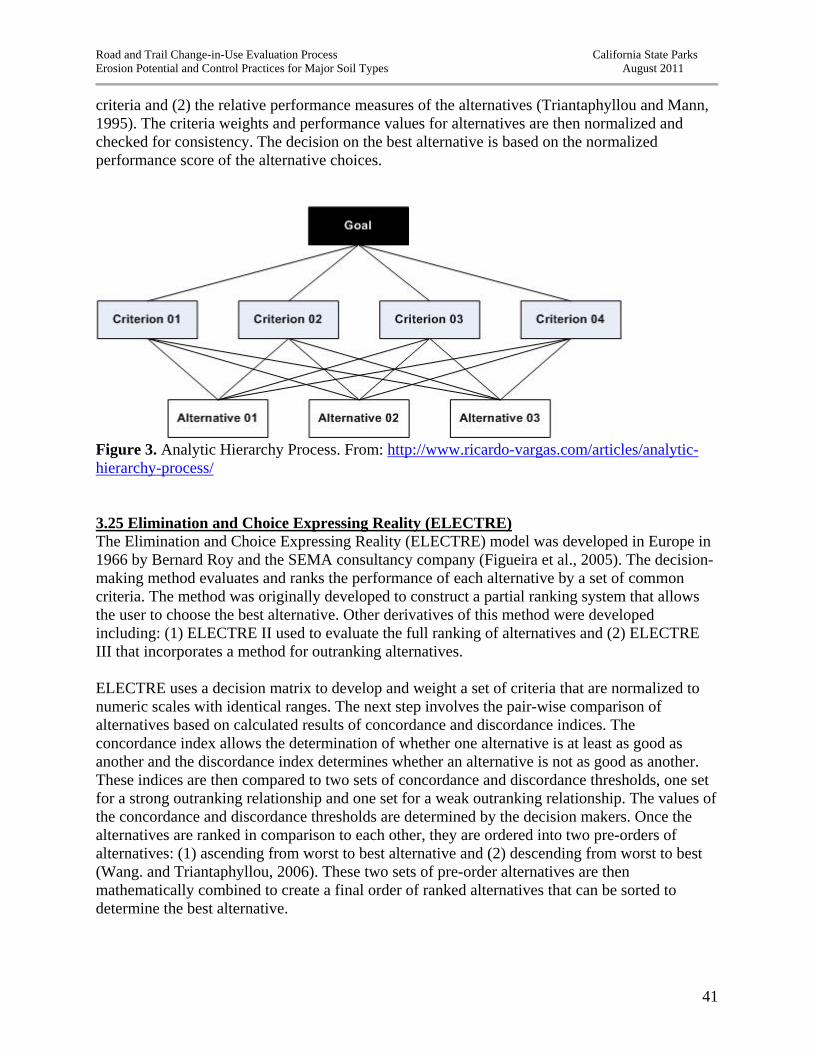
Road and Trail Change-in-Use Evaluation Process California State Parks Erosion Potential and Control Practices for Major Soil Types August 2011
41
criteria and (2) the relative performance measures of the alternatives (Triantaphyllou and Mann, 1995). The criteria weights and performance values for alternatives are then normalized and checked for consistency. The decision on the best alternative is based on the normalized performance score of the alternative choices.
Figure 3. Analytic Hierarchy Process. From: http://www.ricardo-vargas.com/articles/analytic-hierarchy-process/ 3.25 Elimination and Choice Expressing Reality (ELECTRE) The Elimination and Choice Expressing Reality (ELECTRE) model was developed in Europe in 1966 by Bernard Roy and the SEMA consultancy company (Figueira et al., 2005). The decision-making method evaluates and ranks the performance of each alternative by a set of common criteria. The method was originally developed to construct a partial ranking system that allows the user to choose the best alternative. Other derivatives of this method were developed including: (1) ELECTRE II used to evaluate the full ranking of alternatives and (2) ELECTRE III that incorporates a method for outranking alternatives. ELECTRE uses a decision matrix to develop and weight a set of criteria that are normalized to numeric scales with identical ranges. The next step involves the pair-wise comparison of alternatives based on calculated results of concordance and discordance indices. The concordance index allows the determination of whether one alternative is at least as good as another and the discordance index determines whether an alternative is not as good as another. These indices are then compared to two sets of concordance and discordance thresholds, one set for a strong outranking relationship and one set for a weak outranking relationship. The values of the concordance and discordance thresholds are determined by the decision makers. Once the alternatives are ranked in comparison to each other, they are ordered into two pre-orders of alternatives: (1) ascending from worst to best alternative and (2) descending from worst to best (Wang. and Triantaphyllou, 2006). These two sets of pre-order alternatives are then mathematically combined to create a final order of ranked alternatives that can be sorted to determine the best alternative.

Road and Trail Change-in-Use Evaluation Process California State Parks Erosion Potential and Control Practices for Major Soil Types August 2011
42
3.26 Multi-criteria decision method limitations and suitability for the State Parks PEIR The Simple Additive Method (SAW) is the most commonly used multi-criteria decision tool. The model uses a very simple mathematical structure that can be grasped by all users. The simplicity of the model lends itself to criticism due to a number of factors. First, the method depends on a subjective estimate for criteria weighting. This can introduce error, if decision makers are biased in the interpretation of criteria importance and sensitivity. The method also requires that the criteria ranking system be normalized or standardized to adjust for different measurement units for criteria. Although the problem of error associated with the normalization of criteria ranking and criteria weighting is also an issue with the TOPSIS, AHP, and ELECTRE models. The WPM model eliminates that problem associated with normalization, because its mathematical structure makes the criteria units dimensionless. By far, the SAW method is the most appropriate multi-criteria decision tool for the State Parks PEIR. It is based on a simple additive formula and considers as many relevant criteria as are needed to make an informed decision on a road or trail change-in-use project. The method has limitations, as stated above, but it has been rigorously tested and validated by a variety of mathematicians, statisticians, and multi-criteria decision analysis theoreticians. This method requires a subjective determination of criteria weights and factor rankings, but these estimates will be made using information from available literature and scientific studies, consultations with subject-area experts in road and trail erosion processes, and with input and guidance from State Parks staff. The SAW method can provide a straightforward and defensible method for decision-making for road and trail change-in-use projects that have a variety of complex environmental conditions and user-defined issues. The WPM method was not considered to be appropriate for the State Parks road and trail change-in-use process. Although this method is simple like the SAW method, it has not been as well used or validated as the SAW method. Although the WPM method benefits in a dimensionless analysis, a factor ranking system employed in the SAW method will provide standardized criteria values and allow a dimensionless analysis. TOPSIS, AHP and ELECTRE are the most complex of the models reviewed. These models are based on complex mathematical relationships between criteria and alternatives, and as a result require more complex statistical computations and knowledge of their mathematical structure. Commercial software is available for both the ELECTRE and AHP models (e.g. “ELECTRE Pro” and “Expert Choice”), but the expense for the general user may be prohibitive. Also, both ELECTRE and AHP methods rely on pair wise comparisons of all alternatives to each criterion. If the problem is dependent on numerous criteria, then the mathematical process increases, as does the number of pair-wise decisions. Based on their complexity, these complex methods would not be appropriate for general use by State Parks staff in developing decisions on road or trail change-in-use projects,
Road and Trail Change-in-Use Evaluation Process California State Parks Erosion Potential and Control Practices for Major Soil Types August 2011
43
4. STATE PARKS PEIR ROAD AND TRAIL CHANGE-IN-USE CONCEPTUAL DECISION-MAKING PROCESS 4.1 CONCEPTUAL ROAD AND TRAIL CHANGE-IN-USE DECISION-MAKING PROCESS The decision-making process can be very difficult and frustrating when many related and unrelated issues or criteria influence the outcome of a final decision. Decisions are sometimes based upon emotional or biased judgments and do not involve the assessment of relevant and important information that would lead to rational and informed decisions. Using a structured process, such as a multi-criteria decision model, allows the decision maker to systematically evaluate relevant and related criteria that may have a significant effect on a decision option. A structured analysis allows the evaluation of the importance and effect of these criteria and prevents the decision maker from being distracted by information that may not be relevant or have a significant impact on the final decision. A multi-criteria model approach to the State Parks Road and Trail Change-In-Use Evaluation Process would provide a systematic, straightforward, and repeatable method for evaluating erosional impacts from a proposed change in use of a road and trail system or segment. The challenge is to develop to a multi-criteria decision model that evaluates environmental and user-type criteria that have an effect on erosion of the road and trail system, determine the magnitude of effects that these criteria have on a road or trail proposed for a change in use, and determine whether the existing road or trail has the capacity to allow the change in use or whether the proposed change would cause significant erosional effects. The proposed method provides a baseline for existing road and trail conditions and guides the decision maker to develop an informed management decision that has the least significant erosional effects. The proposed State Parks Road and Trail Change-In-Use Evaluation Process involves a series of steps to determine one of three alternatives: (1) a road and trail change-in-use proposal is appropriate for the existing conditions of the road or trail, (2) a road and trail change-in-use proposal is appropriate if best management practices (BMPs) are employed to mitigate significant erosional effects, or (3) a road and trail change-in-use proposal is not appropriate because implemented BMPs cannot reduce the significant erosional effects caused by the proposed change in use. The third alternative results in refusing the proposed change in use or conducting further EIR analysis. Figure 4 describes the proposed SPEIR road and trail change-in-use multi-criteria, decision-making process. The process follows general decision-making theory where a problem is defined (whether to change the use of a road or trail); the possible alternatives are stated (see above alternatives); attributes or criteria that influence the alternatives are evaluated (risk analysis or existing conditions assessment); the standards of the attributes or criteria are specified; a mathematical decision-making model is applied; best management practices that will ensure the best alternative are identified; the best alternative is evaluated and selected; and the chosen alternative is implemented and monitored. This approach to decision making is similar to a strategy developed in 1985 by the U.S. Forest Service (Stankey et al., 1985). The Limits of Acceptable Change for Wilderness Planning is a method developed for land managers to determine whether recreational areas can tolerate increased recreational uses. The method uses
Road and Trail Change-in-Use Evaluation Process California State Parks Erosion Potential and Control Practices for Major Soil Types August 2011
44
field methods to evaluate the existing conditions of the resource areas and develops standards for the attributes or criteria that have an effect on the resource conditions. The information is then analyzed using a cost/benefits analysis (in terms of environmental and visitor impacts, and administrative costs) for each alternative. The best alternative exhibits the least impacts and acceptable costs. PWA will develop the draft list of environmental and user-type criteria that will be ranked and weighted for the decision-making process. The criteria, and their rankings and weights, will be reviewed with State Parks staff prior to final development and population of the road and trail change-in-use decision model. PWA will also develop a spreadsheet for use in the State Parks PEIR that analyzes and calculates the best alternative using the Simple Additive Weighting (SAW) method. The steps to the SPEIR decision-making process (Figure 4) include: Step 1. Define the problem – State the proposed change in use. Step2. Conduct a risk analysis – Collect field-based and other available data on the environmental and user-type criteria that could have erosional impacts from the proposed road or trail change in use. This data should be collected when assessing the trail as part of the State Parks road and trail change-in-use process. For example, this data should be collected when conducting or updating the State Parks condition assessment log or when conducting the CGS watershed assessment for the area or trail in question. PWA conducted an extensive literature review of the criteria that can have significant effects on erosion of the road or trail system and based on our expertise developed a list of criteria that could have significant erosional effects from a road or trail change-in-use proposal (Table 1). A brief summary of these variables and their application and utility in the existing State Parks procedures (e.g. trail log and change-in-use survey form) is provided in Section 6 of this report. Of the criteria listed in Table 1, the trail related, geomorphic, erosion feature type criteria will be assessed during the field inspection of the road or trail proposed for a change in use. These criteria should be incorporated into the trail log or CGS watershed tool data form. It would benefit the State Parks efficiency, and in administrative and staff costs, if these criteria were collected as part of trail assessments that are being conducted simultaneously. The remaining criteria, including meteorological, soil-related, and user-defined criteria can be collected as an office exercise. Annual precipitation and trail user information should be available through State Parks existing data. The soils data can be obtained from the USDA STATSGO2 (Web Soil Survey) data or, if available, from other soil studies conducted in the regional area. Although the soils data from the USDA Web Soil Survey may be general and at a gross scale in some areas, using a statewide database ensures systematic and consistent soil attribute information and dos not rely on a field call made by staff that may not have the needed soils expertise.

Road and Trail Change-in-Use Evaluation Process California State Parks Erosion Potential and Control Practices for Major Soil Types August 2011
45
Table 1. Environmental and user-type attributes and criteria that affect erosion on roads and trails Attribute Attribute type Criteria
Environmental
Meteorological Annual precipitation
Soils
Soil permeability Soil runoff Soil erosion hazard Shrink and swell potential Wind erodibility index
Erosion features
Surface erosion Rills Gullies Landslides
Road/Trail
Prism width Tread width Average trail grade Steepest trail grade Tread material type Tread material infiltration Wet, muddy areas
Geomorphologic Average hillslope gradient Slope shape Geomorphic position
User-defined
User-type Intensity Length of time of use Season of use

Road and Trail Change-in-Use Evaluation Process California State Parks Erosion Potential and Control Practices for Major Soil Types August 2011
46
Road/Trail Conceptual Change-in-Use Decision Process
Define problem: Proposed road and trail change in use
Conduct risk analysis: Collect field based and other criteria data
Create decision matrix: List and rank attributes/criteria and list criteria weights
Conduct decision analysis: Simple Additive Weighting (SAW) What are the baseline conditions and does the proposed change in use have
significant erosional effects?
Yes, the proposed change in use will have significant effects: SAW with change in use – no mitigation
No, the proposed change will not have significant effects
Propose project alternatives (BMPs or mitigation strategies) that meet project goals but reduce or
eliminate significant effects
Proposed change in use accepted
Employing mitigation, does the proposed change-in-use still have significant effects?
SAW with change-in-use – with mitigation
Yes, the proposed change-in-use project will still have
significant effects
No, the proposed change-in-use project will not
have significant impacts
Proposed change-in-use denied
Further EIR analysis required
Figure 4. State Parks PEIR Road and Trail Change-In-Use conceptual decision-making process

Road and Trail Change-in-Use Evaluation Process California State Parks Erosion Potential and Control Practices for Major Soil Types August 2011
47
The risk or performance ranking for each criterion will be based on a dimensionless scale of 1 to 5, with 1 being the highest risk of erosion and 5 being the lowest risk of erosion. The final list of criteria collected and the measurement protocol, as well as the criteria ranking will be developed for the next phase of the State Parks PEIR, with consultation and guidance from State Parks staff. Information collected as part of the risk analysis will be entered into a decision matrix as part of Step 3. Step 3. Construct the decision matrix – As mentioned in Section 4, the decision matrix is a fundamental part to the multi-criteria decision analysis. A decision matrix is an L-shaped table listing the attributes and criteria in the rows: and criteria weights, criteria alternative performance rankings, and alternatives listed in the columns. Table 2 shows an example of the decision matrix for the State Parks PEIR road and trail change-in-use decision process. This decision matrix is the first step to conducting the Simple Additive Weighting (SAW) multi-criteria decision analysis to determine if a proposed road and trail change in use is a preferred alternative. The decision matrix includes the inter-criteria weight and the intra-criteria performance rank. The inter-criteria weight is the relative weight of importance of a criterion relative to or amongst criteria. The inter-criteria weight will be calculated by PWA using a method of pair-wise comparison utilizing Saaty’s nine point cardinal scale (Table 3). Criteria are compared to each other within a pair-wise decision matrix to determine which criterion is more important relative to the other. Each criterion weight is computed in the pair-wise decision matrix (n x n) and checked for consistency by determining the average random consistency ratio. The consistency ratio allows a check to make sure that the weights have been judged consistently. If the consistency ratio is not acceptable, then the comparison analysis will be reviewed and refined until the consistency ratio is an acceptable value. The intra-criteria rank is the performance rating of each criterion dependent on the each alternative analyzed. As mentioned previously, PWA will provide a ranking system for each criterion based on a non-dimensional cardinal scale of 1 to 5, with 1 being the poorest performance (most significant erosional effect) and 5 being the best performance (no significant erosional effect). In Table 2 an intra-criteria rank is associated with each of the 3 alternatives: A, B, and C. The intra-criteria rank for “Alternative A: Existing conditions” refers to the ranking derived directly from the risk analysis: Step 2 and reflects the existing conditions of the road or trail proposed for a change in use. “Alternative B: road and trail change in use, no mitigation” refers to a situation where a change in use is accepted, but no mitigation measures are implemented to control any erosion associated with the change in use or existing erosion problems. To develop the intra-criteria rank for Alternative B, the decision maker would change the intra-criterion rank that would reflect the change in use proposed. For example, if mountain bikers were added to the use of a hiker-only trail with no proposed mitigations, then the criterion performance rank for user-type would change to the appropriate rank for hikers and mountain bike usage combined. “Alternative C: road and trail change in use, with mitigation” refers to a situation where a change in use is accepted and mitigation strategies are implemented to treat potential erosion resulting from the change in use and existing erosion problems identified during the risk analysis. To

Road and Trail Change-in-Use Evaluation Process California State Parks Erosion Potential and Control Practices for Major Soil Types August 2011
48
calculate the criterion performance ranks for Alternative C, the decision maker would adjust the criterion performance ranks to reflect change in use and any performance criterion rank changes associated with implemented mitigation measures. For example, if the trail change in use described previously incorporates mitigation measures that treat erosion impacts, then some of the criterion performance ranks for erosion features and trail characteristics would increase (decrease significant erosional impacts). Using this decision matrix and the Simple Additive Weighting (SAW) method allows the scoring of each alternative. Alternative scores will change based on the adjustment of the criterion performance rank in each scenario. It is important to note that criteria performance ranks for meteorological, soils, and geomorphic data will remain constants because these criteria depict the baseline natural environmental conditions and obviously cannot be adjusted through mitigation efforts. The application of the SAW method will be discussed in Step 4. Step 4: Conduct decision analysis for Alternatives A, B, and C – The multi-criteria decision analysis will be conducted using the Simple Additive Weighting (SAW) method described in Section 4. The method requires the estimation of the best and worse performance scores for a road and trail change-in-use decision analysis. PWA will calculate the potential best and worst average weighted performance scores for the final road and trail change-in-use decision matrix used in the State Parks PEIR document. PWA will also provide State Parks with the decision matrix as an MS Excel spreadsheet that is designed to calculate the weighted performance scores for the 3 alternatives. To calculate the best performance score, the criteria performance rankings will be set at a scale of 5 (the best performance or no significant erosion effects). The worst performance score will be obtained by setting all of the criteria performance rankings to 1 (the worst performance or extreme significant erosion effects). To develop the maximum and minimum scores, the SAW equation will be applied by summing the products of the criteria performance rankings and the criteria weights. By determining the maximum and minimum score for the SAW decision matrix, one can develop a frame of reference or the minimum score value that determines acceptability of the road and trail change in use. The minimal acceptable score that would permit a change in use will be mathematically calculated by PWA and provided as part of the final PEIR analysis. To conduct the SAW analysis for a change-in-use proposal, the decision maker will populate the decision matrix by entering the appropriate alternative criteria performance rankings for Alternatives A, B, and C. As stated previously, Alternative A intra-criteria performance rankings are derived from the risk analysis and represent existing conditions, Alternative B analysis requires all criteria performance rankings used for Alternative A with exception to the change in use or use type. The use type criterion performance ranking should be changed to include all uses as a result of the proposed change in use. For example, if mountain bikes are added to a hikers-only trail, then the use type would be hikers/mountain bikes and the criteria performance ranking for that use type would be entered into the matrix. Alternative C criteria performance changes would include all criteria performance rankings delineated in Alternative B, except for criterion performance rankings that would change based on mitigation strategies.

Road and Trail Change-in-Use Evaluation Process California State Parks Erosion Potential and Control Practices for Major Soil Types August 3, 2011
49
Table 2. Example of State Parks PEIR decision matrix
Attributes Criteria Inter-Criteria standardized
weight
Alternatives
A: Existing conditions: remains same
B: Change in use, no mitigation
C: Change in use, with mitigation
Intra-Criteria
rank Alt. A Score
Intra-Criteria
rank Alt. B Score
Intra-Criteria
rank Alt. C Score
Environmental
Meteorological Annual precipitation
Soils
Soil permeability and runoff USDA Web Soil Survey soil erodibility factor (K factor) Shrink and swell potential
Wind erodibility index
Existing erosion features
Surface erosion Rills Gullies
Landslides
Trail
Trail width (ft) Tread width (ft) Average trail grade (%) Steepest trail grade (%) Tread material type Tread material infiltration Tread material erodibility
Wet, muddy areas
Geomorphologic
Average slope gradient (%) (perpendicular to trail tread) Slope shape (planar, convergent, divergent, hummocky)
User-defined Use
Type of use Intensity Length of time of use
Season Use
Totals

Road and Trail Change-in-Use Evaluation Process California State Parks Erosion Potential and Control Practices for Major Soil Types August 3, 2011
50
Table 3. Saaty’s nine point scale for pair-wise importance1 Intensity of importance Definition Explanation
1 Equal importance Indifferent - Two criteria contribute equally to the objective
2 Weak or slight
3 Moderate Slightly better - Experience and judgment slightly favor one criteria over another
4 Moderate plus
5 Strong Better - Experience and judgment strongly favor one criteria over another
6 Strong plus
7 Very strong Much better - A criteria is favored very strongly over another
8 Very, very strong
9 Extreme Most important - The evidence favoring one criteria is of the highest importance.
1 Derived from Afshari et al. 2010 Decision makers must use professional judgment on the new criteria performance rankings developed, if mitigation strategies are implemented. The criteria weights do not have to be populated by the decision maker, because the weights will automatically be a component of the decision-matrix template. Once the criteria performance rankings have been populated, the criteria scores and final score for each alternative will be automatically calculated and provided at the bottom of the spreadsheet. Finally, determine the best alternative based on the final weighted score and compare with the minimum acceptable score for a road and trail change in use. 4.2 HYPOTHEICAL NUMERIC EXAMPLE OF THE STATE PARKS ROAD AND TRAIL CHANGE-IN-USE SAW DECISION ANALYSIS To illustrate the use of the decision matrix and the multi-criteria analysis using the SAW method for the decision to change the use of a road or trail, a hypothetical example has been prepared with artificial criteria weights and criteria performance rankings (Table 4). This is only intended as an example and does not reflect the final criteria, weights and rankings that will be used in the final PEIR road and trail change-in-use decision analysis. This hypothetical example shows the difference in alternative scores for a road or trail change-in-use proposal where mountain bike use is being added to a hiking only trail system. The highest weighted average performance score for a potential alternative is 5. This is based on the assumption that there are no significant erosional effects and all the criteria performance

Road and Trail Change-in-Use Evaluation Process California State Parks Erosion Potential and Control Practices for Major Soil Types August 3, 2011
51
rankings are set at 5. The lowest weighted average performance score for a potential alternative is equal to 1. This assumes that all criteria are contributing to severe erosion and criteria performance rankings are set at 1. The hypothetical trail in this example has erodible soils, steep trail grade, exhibits erosion problems, and is in an area with relatively high annual precipitation. To calculate the total performance score for Alternative A, the intra-criteria rankings are entered from the risk analysis. To reiterate, Alternative A represents baseline conditions. The total score for Alternative A is 2.46, which is slightly more than 50% of the optimal performance score of 5 (Table 4). To calculate “Alternative B: proposed change in use – no mitigation”, all of the criteria performance rankings are the same as in Alternative A except for the criteria performance ranking for use type. Because mountain bikes are being added to the use type, the criteria performance rank for use type must change to the value for hiking and mountain biking combined. A combined hiking and mountain biking use type has a lower criteria performance ranking compared to hiking-only use-type. As a result the total average weighted score for Alternative B (2.28) is lower than Alternative A (existing conditions). Alternative B is nearly 55% lower than the optimal performance score of 5. In addition, the score for Alternative B is approximately 7% lower than the total performance score for Alternative A. Based on these results, the trail does not support the added use based on existing conditions and will experience further significant impacts from erosion. The next step involves: (1) determining the mitigation strategies that can treat existing and expected erosion problems, (2) incorporating these mitigations into the decision matrix, and (3) calculating the total average weighted score for “Alternative C: proposed change in use – with mitigation”. For the hypothetical example, it was assumed that mitigation strategies could be employed to reduce or eliminate significant erosional impacts, including: (1) treating existing and potential erosion problems, (2) modifying the trail tread width to reduce the area of bare soil that is prone to erosion, (3) apply gravel or other surfacing to the trail tread, and (4) install drainage structures at springs or stream crossings to reduce or eliminate trail runoff and muddy areas. For Alternative C, the intra-criteria performance rankings were adjusted to accommodate these mitigation measures. The total weighted performance score for Alternative C is equal to 3.10. This value is 38% lower than the optimal performance score of 5, although it only increased the performance level 12% above the baseline conditions (2.46). Although the performance score of “Alternative C: proposed change in use – with mitigation” increased, it did not change significantly. The score for Alternative C is only 3% higher than the median of the possible performance score of 3 (median of the lowest: 1 to highest: 5). Depending upon the minimum score that dictates whether a change in use is appropriate, a performance score of 3.1 may not be enough to warrant the change in use or may require a more detailed environmental study.
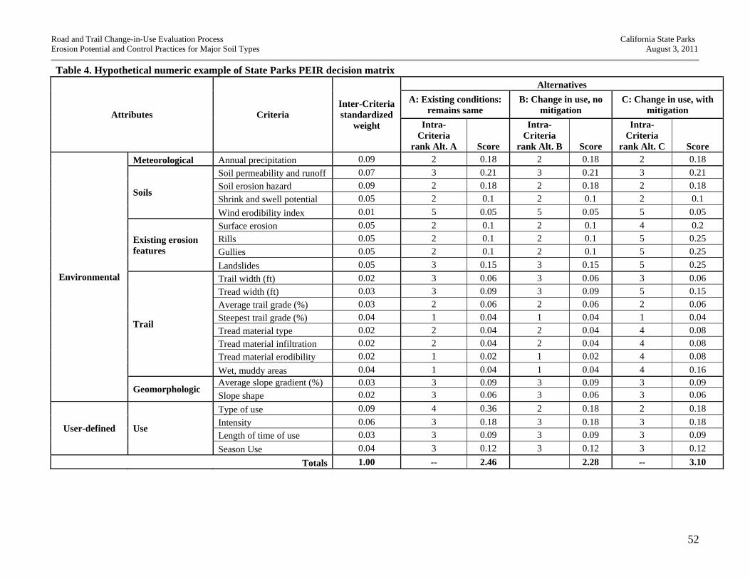
Road and Trail Change-in-Use Evaluation Process California State Parks Erosion Potential and Control Practices for Major Soil Types August 3, 2011
52
Table 4. Hypothetical numeric example of State Parks PEIR decision matrix
Attributes Criteria Inter-Criteria standardized
weight
Alternatives
A: Existing conditions: remains same
B: Change in use, no mitigation
C: Change in use, with mitigation
Intra-Criteria
rank Alt. A Score
Intra-Criteria
rank Alt. B Score
Intra-Criteria
rank Alt. C Score
Environmental
Meteorological Annual precipitation 0.09 2 0.18 2 0.18 2 0.18
Soils
Soil permeability and runoff 0.07 3 0.21 3 0.21 3 0.21
Soil erosion hazard 0.09 2 0.18 2 0.18 2 0.18
Shrink and swell potential 0.05 2 0.1 2 0.1 2 0.1
Wind erodibility index 0.01 5 0.05 5 0.05 5 0.05
Existing erosion features
Surface erosion 0.05 2 0.1 2 0.1 4 0.2
Rills 0.05 2 0.1 2 0.1 5 0.25
Gullies 0.05 2 0.1 2 0.1 5 0.25
Landslides 0.05 3 0.15 3 0.15 5 0.25
Trail
Trail width (ft) 0.02 3 0.06 3 0.06 3 0.06
Tread width (ft) 0.03 3 0.09 3 0.09 5 0.15
Average trail grade (%) 0.03 2 0.06 2 0.06 2 0.06
Steepest trail grade (%) 0.04 1 0.04 1 0.04 1 0.04
Tread material type 0.02 2 0.04 2 0.04 4 0.08
Tread material infiltration 0.02 2 0.04 2 0.04 4 0.08
Tread material erodibility 0.02 1 0.02 1 0.02 4 0.08
Wet, muddy areas 0.04 1 0.04 1 0.04 4 0.16
Geomorphologic Average slope gradient (%) 0.03 3 0.09 3 0.09 3 0.09
Slope shape 0.02 3 0.06 3 0.06 3 0.06
User-defined Use
Type of use 0.09 4 0.36 2 0.18 2 0.18
Intensity 0.06 3 0.18 3 0.18 3 0.18
Length of time of use 0.03 3 0.09 3 0.09 3 0.09
Season Use 0.04 3 0.12 3 0.12 3 0.12
Totals 1.00 -- 2.46 2.28 -- 3.10

Road and Trail Change-in-Use Evaluation Process California State Parks Erosion Potential and Control Practices for Major Soil Types August 3, 2011
53
4.3 CONSISTENCY AND TRANSPARENCY OF THE CONCEPTUAL DECISION-ASSISTANCE TOOL WITH STATE PARKS EXISTING ROAD AND TRAIL CHANGE-IN-USE PROCEDURES The intent of the State Parks Road and Trail Change-In-Use Evaluation Process decision-assistance tool is to help decision makers make informed decisions about changes in use on roads and trails related to erosion vulnerability. The decision-assistance tool is intended to work in conjunction with existing State Parks trail assessment procedures such as the State Parks Trail Log and the Trail Use Change Survey, and the Watershed Assessment Tool (being developed for State Parks by the California Geological Survey). A State Parks Trail Log is required when a road or trail change in use is requested and involves the systematic collection of data pertaining to existing and potential erosion problems, trail sustainability issues, and allows for the prescription of mitigation measures to treat trail alignment problems. It uses census and sampling procedures, whereby a qualified staff person uses a distance measuring wheel and collects the location (distance) on the alignment where erosion problems occur and where mitigation measures will be implemented. The Trail Log also collects detailed information on the trail characteristics and erosion problems. The CGS Watershed Assessment Tool was developed for State Parks to inventory the State Parks road and trail system in a natural resource context for sources of erosion and to develop prioritized treatments with the goal of minimizing the impacts of erosion and runoff from poorly designed roads and trails. The conceptual decision tool requires specific criteria that are to be used to evaluate existing conditions and determine whether a road or trail change in use is appropriate. This decision framework criteria data are either currently collected as part of the Trail Log or the CGS Watershed Assessment tool or need to be incorporated into one of these inventory procedures. The criteria data requirements for the decision-assistance should not require an additional assessment of the trail system. It is important to provide a usable decision tool that is efficient and does not require significant additional staff and administrative costs. PWA will meet with State Parks staff and review the existing procedures to see which State Parks data collection effort (e.g. Trail Log, CGS, etc.) should incorporate the additional data assessment requirements in the context of the timing of road and trail change-in-use proposals. It seems appropriate that the additional data should be collected during the Trail Log assessment, because a Trail Log is required in response to a road or trail change-in-use proposal. The CGS Watershed Assessment is a single assessment of roads and trails that is currently being conducted on State Parks lands. Because road and trail change-in-use proposals occur sporadically and in a variety of State Park units, the CGS watershed assessment may not reflect the current conditions of the road or trail proposed for a change in use. Even though the CGS watershed assessment was conducted on a road or trail proposed for a change in use, a Trail Log would have to be completed, as required by the current State Parks Road and Trail Change-in-Use Evaluation Process procedures.
Road and Trail Change-in-Use Evaluation Process California State Parks Erosion Potential and Control Practices for Major Soil Types August 3, 2011
54
A State Parks Trail Use Change Survey is also required for each road or trail change-in-use proposals. The Trail Use Change survey evaluates the road and trail proposed for a change in use in the context of CEQA and trail user needs and expectations. The survey form includes general questions regarding existing conditions; compatibility for multi-use trails; and effects on trail user circulation patterns, trail use safety, trail sustainability, natural and cultural resources, and facility maintenance and operational costs. Currently, State Parks staff use the information collected in the Trail Log to answer the questions related to erosion risk and trail erodibility. The Trail Use Change Survey Form, by itself, does not result in a rigorous analysis that can provide a definitive decision on whether a road or trail can support a change in use. Although the survey form includes numeric data on the number of trail drainage structures, linear feet of rutting and rilling; the form also includes questions requiring subjective judgment, such as “Is the tread firm and stable?” or “Is the fillslope stable?” These general questions are qualitative and can lead to biased and subjective assessment of the road or trail existing conditions. The additional criteria data required by the conceptual decision-assistance tool provides quantitative data that can be used to develop rational and informed answers to the general survey questions in a systematic and repeatable manner. 5. CONCLUSIONS Soil erosion from road and trail networks results from a variety of factors including environmental, management-related, and different trail uses (e.g. hikers, horses, mountain bikes, etc.). Making decisions about changing the use of a road or trail can be a difficult task because of the variety of factors and the magnitude of their effects on soil erosion. Many management decisions are made using subjective and potentially biased judgments based on observational interpretation or intuition and not upon available technical information and sound science. Erosion models and assessment methods may focus on a few environmental factors contributing to erosion (e.g. soils or precipitation), but ignore other significant management or user-defined factors that may have equal or larger effects on soil erosion. Complex decisions involving multiple criteria require a systematic approach to evaluating all factors that can contribute to negative environmental effects (e.g. soil erosion). A multi-criteria decision-assistance tool, such as the Simple Additive Weighting (SAW) method offers a powerful tool for State Parks decision makers when determining whether roads or trails can accommodate changes in use. This simple and straightforward decision-making method weighs the importance of environmental, management-related, and user-defined criteria; evaluates the existing conditions; and tests the baseline conditions to see if a proposed change in use will have a negative effect on soil erosion. A decision-assistance tool provides State Parks with a defensible, transparent, and repeatable method that can be used statewide on all park lands. Although, a decision-assistance tool still requires subjective determinations of the performance ranking system and importance weights for environmental, management-related, and user-defined criteria, the increasing abundance of relevant scientific studies and literature and the expertise and experience of professional trails experts in the State Parks trails program
Road and Trail Change-in-Use Evaluation Process California State Parks Erosion Potential and Control Practices for Major Soil Types August 3, 2011
55
will combine to provide a solid basis for the determination of relevant criteria and weightings to be employed when implementation of the decision-assistance tool. The values and output provided by this tool utilize logical and systematic methods in a transparent process to provide information that will assist park managers in arriving at sound resource management and visitor access decisions for their park. 6. REFERENCES ARS–USDA, 1995, WEPP user summary, USDA-Water Erosion Prediction Project,
Flanagan, D.C. and Livingston, S.J., eds., NSERL Report, no. 11, 141 p.
Agate, E., 1996, Footpaths: a Practical Handbook, British Trust for Conservation Volunteers, London, UK: The Eastern Press Ltd.
Anderson, H.W., 1972, Evaluating sedimentation and streamflow turbidity hazards in wildland use, File report, Southwest Forest and Range Experiment Station, U.S. Forest Service, Berkeley, California.
Anderson, H.W., 1974, Sediment deposition in reservoirs with rural roads, forest fires, and catchment attributes, in Proceedings International symposium on man’s effect of erosion and sedimentation, UNESCO-IAHS, September 9-12, 1974, Paris, p 87-95.
Aust, M.W., Marion, J.L., and Kyle. K., 2005, Research for the development of best management practices for minimizing horse trail impacts on the Hoosier National Forest, U.S. Forest Service, Final Research Report, College of Natural Resources, Department of Forestry, Blacksburg, Virginia, ii, 80 p.
Bainbridge, D.A., 1974, Trail Management, Bulletin of the Ecological Society of America, v. 55 (3), p. 8-10.
Birchard, W. Jr., and Proudman, R.D., 1981, Trail Design, Construction, and Maintenance, 2nd ed. Harpers Ferry, West Virginia: Appalachian Trail Conference, 166 p.
Birchard, W. and Proudman, R.D., 2000, Appalachian Trail Design, Construction, and Maintenance, 2nd ed., Harpers Ferry, WV: Appalachian Trail Conference.
Blaszczynski, J., 2001, Regional sheet and rill soil erosion prediction with the Revised Universal Soil Loss Equation (RUSLE) – GIS Interface: U.S. Bureau of Land Management Resource Notes, no. 46, 2 p.
Bonilla, C.A., Reyes, J.L., and Magri, A., 2010, Water erosion prediction using the Revised Universal Soil Loss Equation (RUSLE) in a GIS framework, Central Chile, Chilean Journal of Agricultural Research, v. 70 (1), p. 159-169.
Bratton, S.P., Graves, J.H., and Hickler, M.G., 1979, Trail erosion patterns in Great Smoky National Park: Environmental Management, v. 3 (5), p. 431-445.
Breibart, A., Harris, J., and Norman, S., 2007, Forest Road BMP Upgrade Monitoring Report 2003-2005, USDA Forest Service, Lake Tahoe Basin Management Unit, South lake Tahoe, CA, 68 p.

Road and Trail Change-in-Use Evaluation Process California State Parks Erosion Potential and Control Practices for Major Soil Types August 3, 2011
56
Bryan, R.B., 1977, The influence of soil properties on degradation of mountain hiking trails at Grovelsjon, Geografiska Annaler, v. 59, p. 49-65.
Burde, J.H. and Renfro, J.R., 1986, Use impacts on the Appalachian Trail, in Lucas, R.C., ed., Proceedings: National Wilderness Research Conference: Current Research. USDA Forest Service, Intermountain Research Station, General Technical Report INT-212, Ogden, UT., p 138-143.
Cal Fire, 2011, Appendix II: Board of Forestry Technical Rule Addendum No. 1, California Forest Practice Rules, Title 14, California Code of Regulations, Chapters 4, 5, and 10,: Sacramento, California, Cal Fire, p. 347-355.
California State Parks, 2002, California Recreational Trails Plan, Department of Parks and Recreation, Scaramento, California, 51 pages.
Cessford, G.R., 1995, Off-Road Impacts of Mountain Bikes, Wellington, New Zealand: Department of Conservation, Science and Research Series, no. 92, 40 p.
Cessford, G.R., 2002, Perception and Reality of Conflict: Walkers and Mountain Bikes on the Queen Charlotte Track in New Zealand, in: Arnberger, A; Brandenburg, C. and Muhar, A. (eds.), Monitoring and Management of Visitor Flows in Recreational and Protected Areas, Proceedings of the Conference held at Bodenkultur University Vienna, Austria, January 30 – February 02, 2002, Vienna, Austria: Institute for Landscape Architecture and Landscape Management, Bodenkultur University.
Chappell, A., 1996, Modeling and spatial variation processes in the redistribution of soil: digital terrain models and 137Cs in southwest Niger, Geomorphology, v. 17, p. 249-261.
Chavez, D., Winter, P., and Baas, J. (1993) Recreational mountain biking: a management perspective. Journal of Parks and Recreation Administration. 11(3), 29-36.
Chavez, D.J., 1997, Mountain bike management: Resource protection and social conflicts, Trends, v. 34 (3), p. 36-40.
Chiu, L and Kriwoken, L., 2003, Managing recreational mountain biking in Wellington Park, Tasmania, Australia, Annals of Leisure Research, v. 6 (4), p. 339-361.
Cole, D.N., 1983, Assessing and monitoring backcountry trail conditions, Res. Pap. INT-303, Ogden UT: U.S. Dept. of Agriculture, Forest Service, Intermountain Research Station, 10 p.
Cole, D.N., 1987, Research on soil and vegetation in wilderness: a state-of-knowledge review, in Lucas, R.C., comp., Proceedings: National Wilderness Research Conference: Issues, state-of- knowledge, and future directions, July 23-26 1985, Fort Collins, Co., Gen. Tech. report INT-220, Ogden Utah: U.S. Department of Agriculture, Forest Service, Intermountain Research Station, p. 135-177.
Cole, D.N., 1988, Disturbance and recovery of trampled montane grassland and forests in Montana, USDA Forest Service, Intermountain Res. Stn., Res. Pap, INT-389, Ogden, UT.

Road and Trail Change-in-Use Evaluation Process California State Parks Erosion Potential and Control Practices for Major Soil Types August 3, 2011
57
Cole, D.N., 1989, Wilderness campsite monitoring methods: a sourcebook, General Technical Report INT-259, Ogden, UT: U.S. Department of Agriculture, Forest Service, Intermountain Research Station.
Cole, D.N, 1990, Recreation in whitebark pine ecosystems: Demand, problems and management strategies, in Schmidt W.C. and K. J. McDonald, comps., Proceedings: Symposium on Whitebark Pine Ecosystems: Ecology and management of a high mountain resource, March 29-31, 1989, Bozeman, MT: USDA Forest Service General Technical Report INT-270. p.305-310.
Cole, D.N., 1991, Changes on trails in the Selway Bitterroot Wilderness, Mountain, 1978-89, US Department of Agriculture, Forest Service, UT:Intermountain Research Station, Ogden, Research paper INT-450.
Cole, D.N., 1995, Experimental trampling of vegetation I: Relationships between trampling intensity and vegetation response, Journal of Applied Ecology, v. 32, p.203-214.
Cole, D.N., 2004, Impacts of Hiking and Camping on Soils and Vegetation: A Review, Cambridge, MA, Environmental impacts of Ecotourism , London, CAB international, no. 2, ch. 4, p. 1-43.
Cole, D.N. and Spildie, D.R., 1998, Hiker, horse, and llama trampling effects on native vegetation in Montana, USA, Journal of Environmental Management, v. 53, p. 61-71.
Cole, D.N., Petersen, M.E., and Lucas, R.C., 1987, Managing wilderness recreation use: common problems and potential solutions. General Technical Report INT-230, USDA Forest Service, Intermountain Research Station, Ogden, Utah
Coleman, R., 1981, Footpath erosion in the English Lake District, Applied Geography, v. 1, p. 121-131.
Dale, D. and Weaver, T., 1974, Trampling effects on vegetation of the trail corridors of north Rocky Mountain forests, Journal of Applied Ecology, v. 11, p. 767-772.
Datzman, P.A., 1978, The erosion hazard rating system of coast forest district. How valid is it as a predictor of erosion and can a better prediction be developed? M.Sc. thesis, Humboldt State University, Arcata, California.
Deluca, T.H., Patterson IV, W.A., Freimund, W.A., and Cole, D.N, 1998, Influence of Llamas, Horses and Hikers on Soil Erosion from Established Recreation Trails in Western Montana, USA, Environmental Management, v. 22 (2), p. 255-262.
Deluca, T.H., Pickering, C.M., Hill, W., Newsome, D., and Leung, Y.F., 2010, Comparing Hiking, Mountain Biking, and Horse Riding Impacts on Vegetation and Soils in Australia and the United States of America, Journal of Environmental Management, v. 91 (3), p. 551-562.
Demrow, C. and Salisbury, D., 1998, The complete guide to trail building and maintenance, 3d ed. Boston, MA: Appalachian Mountain Club, ISBN 1-878239-54-6, 256 p.
Road and Trail Change-in-Use Evaluation Process California State Parks Erosion Potential and Control Practices for Major Soil Types August 3, 2011
58
Dixon, G., Hawes, M., and McPherson, G., 2004, Monitoring and modeling walking track impacts in the Tasmanian Wilderness World Heritage Area, Australia, Journal of Environmental Management, v. 71, p. 305–320.
Doucette, J. and Cole, D., 1993, Wilderness visitor education: Information about alternative techniques, United States Department of Agriculture. February.
Doucette, J.E. and Kimball, K.D., 1990, Passive trail management in northeastern alpine zones: a case study, Proceedings: 1990 Northeastern Recreation Research Symposium. Saratoga Springs, NY, February 25-28, U.S. General Technical Report NE-145, p. 195-201.
Drucker, P., 2001, The effective decision, in: Harvard Business Review on Decision Making, Boston, MA: Harvard Business School Press, p. 1-20.
Elliot, W.J., Whitley, G., Cahill, K., and Villanueva, G., 1999, WEPP: Road (Draft 12/1999) WEPP Interface for Predicting Forest Road Runoff Erosion and Sediment Delivery, USDA Forest Service (USDA FS) Rocky Mountain Research Station and San Dimas Technology and Development Center, Available at: http://forest.moscowfs1.wsu.edu/fswepp/docs/wepproaddoc.html.
Farrell, T. A. and Marion, J. L., 2001, Identifying and assessing ecotourism visitor impacts at selected protected areas in Costa Rica and Belize, Environmental Conservation, v. 28 (3), p. 215-225.
Farrell, T. A. and Marion, J. L., 2002, The Protected Areas Visitor Impact Management (PAVIM) framework: A simplified process for making management decisions, Journal of Sustainable Tourism, v. 10 (1), p.31-51.
Ferguson, J.C., 2005, Modeling Trail Degradation Using Field and GIS Methodologies: A Comparative Study, Raleigh, NC: North Carolina State University, Ph.D. dissertation, 178 p., 27 figs.
Figueira, J., Mousseau, V., and Roy, B., 2005, ELECTRE Methods, in: Multiple Criteria Decision Analysis: The State of the Art Surveys, Figueira, J., Greco, S. and Ehrgott, M., eds., Springer Science+Business Media, Inc., New York, p. 133.162.
Flanagan, D.C., Ascough, J.C. II, Nicks, A.D., Nearing, M.A., and Laflen, J.M., 1995, Overview of the WEPP erosion prediction model, in: USDA Watershed Erosion Prediction Project: Hillslope Profile and Watershed Model Documentation, Chapter 1, Flanagan, D.C. and Nearing, M.A., eds., USDA-ARS NSERL Report 10, West Lafayette, Ind : USDA-ARS National Soil Erosion Research Laboratory.
Gager, P. and Conacher, A.J., 2001, Erosion of access tracks in Kalamunda National Park, Western Australia: causes and management implications, Australian Geographer, v. 32 (3), p. 343-357.
Garland, J.J., 1983, Designing Woodland Roads, Oregon State University Extension Circulation 1137, Oregon State University, Corvallis.
Godwin, I.C.P., 2000, Physiographic Components of Trail Erosion: Bozeman, MT, Master’s thesis, 75 p., 27 figs.

Road and Trail Change-in-Use Evaluation Process California State Parks Erosion Potential and Control Practices for Major Soil Types August 3, 2011
59
Goeft, U. and Alder, J., 2001, Sustainable mountain biking: a case study from the southwest of Western Australia, Journal of Sustainable Tourism, v. 9, p. 193–211.
Grost, R., 1989, Managing the mountain bike. American Forests. 95, 50-77.
Hammit, W.E. and Cole, D.N., 1998, Wildland Recreation: Ecology Management, New York, NY: John Wiley and Sons Inc., 361 p.
Hampton, B., and Cole, D. N., 1995, Softpaths: how to enjoy the wilderness without harming it, Second edition, Harrisburg, PA: Stackpole Books.
Harden, C. P., 1992, Incorporating roads and footpaths in watershed-scale hydrologic and soil erosion models, Physical Geography, v. 13, p. 368-385.
Helgath, S.F., 1975, Trail deterioration in the Selway-Bitterroot Wilderness, USDA Forest Service, Intermountain Research Station, Research Note INT-193, Ogden, Utah.
Hendee, J.C. and van Koch, R., 1990, Wilderness management planning, in: Wilderness management, 2d ed. Hendee, J.C., Stankey,G.H., and Lucas, R.C., eds., Golden, CO: North American Press: p 195-213.
Hendricks, W.W., 1997, Mountain bike management and research: An introduction, Trends, v. 34 (3), p. 2-4.
Hesselbarth, W. and Vachowski, B., 2000, Trail Construction and Maintenance Notebook, Publication 0023-2839-MTDC-P, Missoula, MN: USDA Forest Service, Technology and Development Program.
Hickey, R., Burns, E., Bolte, J., and Walker, D., 2005, Development of a statewide erosion vulnerability screening tool for Oregon: Geography Online, v. 5, no. 2. p. 1-15.
Holmes, D.O., 1979, Experiments on the Effects of Human Urine and Trampling on Subalpine Plants, p. 79-88, in Ittner, R., Potter, D.R., Agee, J.K. and Anschell, S., eds., Recreational Impacts on Wildlands Conference, October 27-29, 1978, Seattle, Washington.
Hood S.M., Zedaker S.M., Aust W.M., and Smith D.W., 2002, Universal Soil Loss Equation(USLE)-predicted soil loss for harvesting regimes in Appalachian hardwoods, Northern Journal of Applied Forestry, v. 19, p. 53-58.
Horn, C., Devlin, P. and Simmons, D., 1994, Conflict in recreation: The case of mountain bikers and trampers, New Zealand: Department of Conservation.
Ishizaka, A. and Labib, A., 2009, Analytic Hierarchy Process and Expert Choice: Benefits and limitations, OR, Insight, vol. 22(4), p. 201–220.
Kouli, M., Soupios, P. and Vallianatos, F., 2008, Soil erosion prediction using the Revised Universal Soil Loss Equation (RUSLE) in a GIS framework, Chania, Northwestern Crete, Greece, Environmental Geology, v. 57, p. 483-497.
Kuss, F.R., 1983, Hiking Boot Impacts on Woodland Trails, Journal of Soil and Water Conservation, v. 38 (2), p. 119-121.
Road and Trail Change-in-Use Evaluation Process California State Parks Erosion Potential and Control Practices for Major Soil Types August 3, 2011
60
Kuss, F.R. and Morgan, J.M., 1980, Estimating the physical carrying capacity of recreation areas: A rationale for application of the Universal Soil Loss Equation, Journal of Soil and Water Conservation, v. 35, p. 87-89.
Kuss, F., Graefe, A., and Vaske, J., 1990, Visitor impact management: A review of research. Washington D.C.: National Parks and Conservation Association.
Landsberg, J., Logan, B., and Shorthouse, D., 2001, Horse riding in urban conservation areas: Reviewing scientific evidence to guide management, Ecological Management and Restoration, v. 2 (1), p.36–46.
Leung, Y.F. and Marion, J.L., 1996, Trail degradation as influenced by environmental factors: A state-of-knowledge review, Journal of Soil and Water Conservation, v. 51 (2), p. 130-136.
Leung, Y. and Marion, J.L., 1999, The influence of sampling interval on the accuracy of trail impact assessment, Landscape and Urban Planning, v. 43, p. 167-179.
Leung, Y.F. and Marion, J.L., 2000, Recreational Impacts and Management in Wilderness: A State of Knowledge Review, in D.N. Cole et al. ed, Proceedings: Wilderness Science in a Time of Change; Volume 5, Wilderness Ecosystems, Threats and Management, p. 23-27, May 1999. Missoula, MT, RMRS-P-15-Vol-5: Ogden, UT, Rocky Mountain Research Station, USDA Forest Service Proceedings, RMRS-P-15, v. 5, p. 23-48.
Leung , Y., Marion, J.L., and Nepal, S.K., 2006, Monitoring trail conditions: Methodological considerations, v. 23, no. 2., p. 36-49.
Li, H. and Xie, Q.S., 2006, Application of TOPSIS in bidding evaluation of manufacturing enterprises-Proceedings of the 5th International Conference on e-Engineering and Digital Enterprise Technology, August 16-18, 2006, Guiyang, China, p. 184-188.
Liddle, M., 1997, Recreation ecology: The ecological impact of outdoor recreation and ecotourism, London. UK: Chapman and Hall, 664 p.
Lopez, T.D.M., Aide, T.M., and Scatena, F.N., 1998, The effect of land use on soil erosion in the Guadiana Watershed in Puerto Rico, Caribbean Journal of Science, v. 34, no.3-4, p. 298-307.
Lucas, R., 1982, Recreation regulations: When are they needed?, Journal of Forestry, v. 80, p. 148-151.
Lutz, H.J., 1945, Soil conditions of picnic grounds in public forest parks, Journal of Forestry, v. 43, p. 121-127.
Maguire, L.A. and Boiney, L.G., 1994, Resolving environmental disputes: A framework incorporating decision analysis and dispute resolution techniques, Journal of Environmental Management, vol. 42, p. 31-48.
Manning, R., 1979, Impacts of recreation on riparian soils and vegetation, Water Resource Bulletin, v. 15, p. 30-43.
Road and Trail Change-in-Use Evaluation Process California State Parks Erosion Potential and Control Practices for Major Soil Types August 3, 2011
61
Marion, J.L., 1994, Trail conditions and management practices in the National Park Service, Park Science, v. 14 (2), p. 16-17.
Marion, J. L., 1998, Recreation ecology research findings: Implications for wilderness and park managers, in National Outdoor Ethic Conference Proceedings, Hannah Kirchner, H., ed., St. Louis, Missouri: New directions for responsible outdoor recreation, Izaak Walton League of America, April 18-21, 1996, p. 188-196.
Marion, J.L. and Cole, D.N., 1996, Spatial and temporal variation in soil and vegetation impacts on campsites, Ecological Applications, v. 6, p. 520-530.
Marion, J. L. and Leung, Y.F, 2001. Trail resource impacts and an examination of alternative assessment techniques, Journal of Park and Recreation Administration, v. 19 (3), p. 17-37.
Marion, J. L. and Leung, Y.F., 2004, Environmentally sustainable trail management, in Ralf Buckley, ed., Environmental Impacts of Ecotourism, Cambridge, MA: CABI Publishing, 416 p.
Marion, J.L. and Olive, T., 2006, Assessing and Understanding Trail Degradation: Results from Big South Fork National River and Recreation Area, in: U.S. Department of the Interior, NPS Research/Resources Management Report, Blacksburg, VA: USGS Patuxent Wildlife Research Center, Virginia Tech Field Unit.
Marion, J. and Wimpey, J., 2007, Environmental Impacts of Mountain Biking: Science Review and Best Practices, in Marion, J., Wimpey, J., eds., Managing Mountain Biking: IMBA’s Guide to Providing Great Riding: Blacksburg, VA, Virginia Tech., Forestry, 15 p.
Marion, J. L., Leung, Y.F., and Nepal, S., 2006, Monitoring trail conditions: new methodological considerations, George Wright Forum v. 23 (2), p.36-49.
Marion, J. L., Roggenbuck, J. W., and Manning, R. E., 1993, Problems and Practices in Backcountry Recreation Management: A Survey of National Park Service Managers, Natural Resources Report NPS/NRVT/NRR-93/12, Denver, CO: USDI National Park Service, Natural Resources Publication Office.
McCool, S. F. and Cole, D.N., comps., 1997, Proceedings: Limits of Acceptable Change and related planning processes: progress and future directions,1997 May 20-22, Missoula, MT., Gen. Tech. Rep. INT-GTR-371, Ogden, UT: U.S. Department of Agriculture, Forest Service, Rocky Mountain Research Station. 84 p.
Morgan, J.M. and Kuss, F.R., 1986, Soil loss as a measure of carrying capacity in recreation environments, Environmental Management, v. 10, p. 263-270.
NCASI, 2002, User Manual for SEDMODL2, National Council for Air and Stream Improvement, Inc., Available at: http:/www.ncasi.org/support/Downloads/Detail.aspx?id=5.
NCASI, 2005, Technical Documentation for SEDMODL Version 2.0 Road Erosion/Delivery Model, National Council for Air and Stream Improvement, Inc., Available at: http:/www.ncasi.org/support/Downloads/Detail.aspx?id=5.

Road and Trail Change-in-Use Evaluation Process California State Parks Erosion Potential and Control Practices for Major Soil Types August 3, 2011
62
NPS (National Park Service), 1995, Economic impacts of protecting rivers, trails, and greenway corridors, Rivers, Trails and Conservation Assistance Program, National Park Service, Available at: www.nps.gov/pwro/rtca/econ_index.htm.
Nepal, S.K., 2003, Trail impacts in Sagarmtha (Mt. Everest) National Park, Nepal: A logistic regression analysis: Environmental Management, v. 32 (3), p. 312-321.
Newsome, D. and Davies, C., 2009, A case study in estimating the area of informal trail development and associated impacts caused by mountain bike activity in John Forrest National Park, Western Australia, Journal of Ecotourism, v. 8 (3), p. 237-253.
Newsome, D., Cole, D.N., and Marion, J.L., 2004, Environmental impacts associated with recreational horse-riding, in: Buckley, R., ed., Environmental Impacts of Ecotourism, New York: CABI International, p. 61-82.
Olive, N.D., Marion, J.L., 2009, The influence of use-related, environmental, and managerial factors on soil loss from recreational trails, Journal of Environmental Management 90, p. 1483–1493.
Pritchett, W.L., 1979, Properties and Management of Forest Soils, New York, NY: John Wiley and Sons.
Proudman, R.D. and Rajala, R., 1981, Trail building and maintenance, 2nd ed., Boston, MA: Appalachian Mountain Club, 286 p.
Quinn, M.S. and Chernoff, G., 2010, Mountain biking: a review of the ecological effects, prepared for Parks Canada, Calgary, AB: Miistakis Institute, University of Calgary.
Quinn, N.W., Morgan, R.P.C., and Smith, A.J., 1980, Simulation of soil erosion induced by human trampling, Journal of Environmental Management, v. 10, p. 155-165.
Renard, K.G., Foster, G.R., Weesies, G.A., McCool, D.K., and Yoder, D.C., 1996, Predicting soil erosion by water: A guide to conservation planning with the Revised Universal Soil Loss Equation (RUSLE), U.S. Dept. of Agriculture, Agriculture Handbook No. 703, 404 p.
Rice, R.M. and Datzman, P.A., 1981, Erosion associated with cable and tractor logging in northwestern California, in Erosion and Sediment Transport in Pacific Rim Steeplands, Proceedings of the Christchurch Symposium, Davies T.R.H. and Pearce, A.J., eds., January 25-31, 1981, Christchurch, New Zealand, Publication 132, Wallingford, UK: International Association of Hydrological Sciences, p 362-375.
Rice, R.M. and Sherbin, S.A., 1977, Estimating Sedimentation from an Erosion-Hazard Rating, Res. Note PSW-RN-323, Berkeley, CA: U.S. Department of Agriculture, Forest Service, Pacific Southwest Forest and Range Experiment Station. 4 p.
Scottish Natural Heritage, 2000, A guide to managing coastal erosion in beach/dunesystems, Natural Heritage Management.
Stankey, G.H., Cole, D.N., Lucas, R.C., Petersen, M.E., and Frissell, S.S., 1985, The limits of acceptable change (LAC) system for wilderness planning, General Technical Report INT-176, Ogden, UT: USDA Forest Service Intermountain Forest and Range Experiment Station, 37 p.

Road and Trail Change-in-Use Evaluation Process California State Parks Erosion Potential and Control Practices for Major Soil Types August 3, 2011
63
Stanley, J.T., Harvey, H.T., and Hartesveldt, R.J., 1979, A Report on the Wilderness Impact Study, Palo Alto, CA: Sierra Club, p. 201 -202.
Sullivan, T., 2002, Evaluating environmental decision support tools, Informal Report #BNL-74699-2005-IR, Environmental Sciences Department, Environmental Research and Technology Division, Brookhaven National Laboratory, 44 p.
Summer, R. M., 1980, Impacts of horse traffic on trails in Rocky Mountain National Park, Journal of Soil and Water Conservation, v. 35, p. 85–87.
Summer, R.M., 1986, Geomorphic impacts of horse traffic on montane landforms, Journal of Soil and Water Conservation, v. 41, p. 126-128.
Sun, D. and Liddle, M.J., 1993, Plant morphological characteristics and resistance to trampling, Environmental Management, v. 17, p. 511-521.
Sutherland, R.A., Bussen, J.O., Plondke, D.L., Evans, B.M., and Ziegler, A.D., 2001, Hydrophysical degradation associated with hiking-trail use: A case study of Hawaii’iloa ridge trail, O’ahi, Hawai’I, Land Degradation and Development, v. 12, p. 71-86.
Teschner, D.P., DeWitt, G.M., and Lindsay, J.J., 1979, Hiking impact on boreal forest vegetation and soils in Vermont’s Northern Green Mountains, University of Vermont, Recreation Management Program, Research Note SNR-RM 6, Burlington, VT.
Thurston, E. and Reader, R.J., 2001, Impacts of experimentally applied mountain biking and hiking on vegetation and soil of a deciduous forest, Environmental Management, v. 27 (3), p 397-409.
Tinsley, B., 1983, Evaluation of trail erosion in Guadalupe Mountains National Park, Texas, Texas Tech University, Master’s thesis, 96 p., 9 figs, 7 plates.
Tinsley, B.E. and Fish, E.B., 1985, Evaluation of trail erosion in Guadalupe Mountain National Park, Montana U.S.A., Conservation Biology, v. 6, p. 253-262.
Triantaphyllou, E., 2000, Multi-Criteria Decision Making Methods: A Comparative Study: Dordrecht, The Netherlands, Kluwer Academic Publishers, 289 p.
Triantaphyllou, E. and Mann, S.H., 1995, Using the Analytical Hierarchy Process for decision making in engineering applications: Some challenges, International Journal of Industrial Engineering: Applications and Practice, vol. 2(1), p. 35-44.
Upitis, A. I., 1980, An integrated study of tracks in Ku-ring-gai Chase National Park with implications for management, BSc (Hons) thesis, Macquarie University, Sydney, Australia.
Wallin, T.R. and Harden, C.P., 1996, Estimating trail-related soil erosion in the humid tropics: Jatun Sacha, Ecuador, and La Selva, Costa Rica, Ambio, v. 25, p. 517-522.
Wang, X. and Triantaphyllou, E., 2006, Ranking irregularities when evaluating alternatives by using some Electre methods, Omega, Vol. 36, No. 1, pp. 45-63.
Washington Department of Natural Resources (WDNR), 1997, Standard Methodology for Conducting Watershed Analysis Manual, Version 4.0, Department of Natural Resources Forest Practices Division, Olympia, Washington.

Road and Trail Change-in-Use Evaluation Process California State Parks Erosion Potential and Control Practices for Major Soil Types August 3, 2011
64
Weaver, T. and Dale, D., 1978, Trampling effects of hikers, motorcycles and horses in meadows and forests, Journal of Applied Ecology, v. 15, p. 451-457.
Weaver, T., Dale, D., and Hartley, E., 1979, The Relationship of Trail Condition to Use, Vegetation, User, Slope, Season and Time, p. 94-100 in Ittner, R., Potter, D.R., Agee, J.K. and Anschell, S., eds., Recreational Impacts on Wildlands Conference, October 27-28, 1978, Seattle, Washington.
Welch, D.M. and Churchill. J., 1986, Hiking trail conditions in Pangnirtung Pass, 1984, Baffin Island, Canada, Parks Canada Report, Ottawa, Canada.
Welsh, M.J., 2008, Sediment production and delivery from forest roads and off-highway vehicle trails in the Upper South Platte River watershed, Colorado, Unpublished MS Thesis, Fort Collins, CO: Colorado State University, 237 p.
White, D. D., Waskey, M.T, Brodehl, G.P., and Foti, P., 2006, A comparative study of impacts to mountain bike trails in five common ecological regions of the Southwestern U.S., Journal of Park and Recreation Administration, v. 24 (2), 20 p.
Whittaker, P.L., 1978, Comparison of surface impact by hiking and horseback rising in the Great Smoky Mountains National Park, Management Report 24, Gatlinburg, TN: U.S. Department of the Interior, National Park Service, Southeast Region, 32 p.
Wilson, J. P., and Seney, J. P., 1994, Erosional impacts of hikers, horses, motorcycles, and off-road bicycles on mountain trails in Montana, Mountain Research and Development, v. 14, p. 77–88.
Yoda, A. and Watanabe, T., 2000, Erosion of Mountain Hiking Trail Over a Seven Year Period in Daisetsuzan National Park, Central Hokkaido, Japan, USDA Forest Service Proceedings, v. 5, p. 172-178.
Yoon, K. and Hwang, C.L., 1995, Multiple Attribute Decision Making: An Introduction, Sage University paper series on Quantitative Applications in the Social Sciences, 07-104, Thousand Oaks, CA, Sage, 75p.