THE LEARNING EDGE: LEADERSHIP STRATEGY with Professor Richard Bawden.
Photo 1
1.7w x 2.1h
.5pt border, color R40/G78/B124
In front of text Horizontal Absolute Position 2.3 to the right of the page
Vertical 2.53 below page Check Lock Anchor Check Allow Overlap
Photo 2
1.7w x 2.1h
.5pt border, color R40/G78/B124
In front of text Horizontal Absolute Position 4.1 to the right of the page
Vertical 2.53 below page Check Lock Anchor Check Allow Overlap
Photo 3
1.7w x 2.1h
.5pt border, color R40/G78/B124
In front of text Horizontal Absolute Position 5.9 to the right of the page
Vertical 2.53 below page Check Lock Anchor Check Allow Overlap
California Levee Vegetation Research Program Influence of Tree Roots and Mammal Burrowing Activity on Levee Performance: Volume 1. – Review of Literature and Case Histories
Diego Cobos Roa, Michelle Shriro, Nicholas Sitar and Jonathan D. Bray Department of Civil and Environmental Engineering University of California Berkeley, CA 94720 Grant funding provided by: The California Department of Water Resources (Contract No. 4600008761) and the Sacramento Area Flood Control Agency (Contract No. 984)
January 2014
Geotechnical Engineering University of California, Berkeley Report UCB GT 13-03 vol. 1
California Levee Vegetation Research Program Influence of Tree Roots and Mammal Burrowing Activity on Levee Performance: Volume 1. – Review of Literature and Case Histories
Diego Cobos Roa, Michelle Shriro, Nicholas Sitar and Jonathan D. Bray Department of Civil and Environmental Engineering University of California Berkeley, CA 94720 Grant funding provided by: The California Department of Water Resources (Contract No. 4600008761) and the Sacramento Area Flood Control Agency (Contract No. 984) January 2014
Geotechnical Engineering University of California, Berkeley Report UCB GT 13-03 vol. 1

i
PREFACE
The California Levee Vegetation Research Program (CLVRP)1 conducted a four-year program of research to resolve gaps in knowledge associated with the effects that woody vegetation growing on or near levees has on levee integrity. This research program was developed in response to recent changes in the enforcement of the vegetation policy of the US Army Corps of Engineers (USACE). For California, compliance with this policy comes with significant monetary and environmental impacts. The series of studies presented herein was undertaken as a part of the CLRVP research program specifically to elucidate the influence that roots of woody vegetation and burrowing animals may have on the long-term performance of levees. The evaluation of the influence of tree roots focused on the potential for enhanced seepage along tree roots from actively growing trees as well as along decaying roots left after tree removal, and on the potential for failure initiation by pullout of the root ball as a result of tree fall on either side of the levee. The evaluation of the impact of animal burrowing activity focused on documenting the typical geometries of burrows of different species, their continuity, their potential to induce seepage and piping, as well as the effectiveness of various burrow remediation treatments.
Overall, the study included experimental and analytical components and is presented in a series of individual volumes, as follows:
1. Literature and case history review was carried out to document and analyze known cases of levee failure and the reported or inferred causes of those failures, concentrating on failures ascribed to either vegetation or animal burrowing activity.
2. Two field seepage experiments were performed on a levee to provide direct measurements of the rate of seepage and the influence of roots on the seepage rate and the seepage path.
3. Two animal burrow sites on a levee were surveyed, treated by injection grouting, and excavated in order to document the volume of the burrows, their geometry, and the effectiveness of different techniques for mitigation.
4. Numerical models were used to evaluate the potential influence of root and animal burrow openings on rate of seepage and their potential to induce levee piping failures.
5. Finally, slope stability analyses were performed to evaluate the influence of different seepage and root geometry scenarios on levee slope stability.
1 Sponsoring Agencies include the CA Department of Water Resources, Sacramento Area Flood Control Agency, CA Central Valley Flood Protection Board, CA Department of Fish & Wildlife, US Fish & Wildlife Service, NOAA, National Marine Fisheries Service, California Central Valley Flood Control Association.

ii
The literature and case history review is presented in Volume 1. Volumes 2 and 3 contain the descriptions and data from the two field seepage experiments. The results of the study of the burrowing mammal activity are presented in Volume 4. The analyses of the influence of various theoretical geometries of openings caused by roots or animal burrows on potential for levee piping or seepage-induced slope failure are presented in Volume 5. Finally, Volume 6 presents the results of analyses of the influence of tree roots on levee embankment stability.
iii
ACKNOWLEDGMENT
This study was performed collaboratively as part of the California Levee Vegetation Research Program (CLVRP) and was sponsored by the local, state, and federal agencies of the California Levees Roundtable through grants from the Sacramento Area Flood Control Agency (SAFCA Contract No. 984), and the California Department of Water Resources (DWR Contract No. 4600008761). A great deal of support was provided by these agencies during our studies. The authors wish to thank Mr. Peter Buck, Program Manager for the CLVRP, consultant Mr. Mick Klasson, Ms. Cassandra Musto and Mr. Roy Kroll of the DWR and Ms. Laura Kaplan of the Center for Collaborative Policy for their invaluable help. We would like to thank the entire CLVRP team for their support and assistance during this research.
The authors would like to acknowledge the local maintaining agencies and landowners that provided access and support to our team during field efforts. Special thanks go to Mr. Tim Kerr, Mr. Richard Marck and the staff of the American River Flood Control District; Mr. Ron King and the staff of Cal Expo; Mr. Rick Carter, Mr. Chris Neudeck, Mr. Juan Mercado and the board of Reclamation District 1601; and Mr. Max Sakato, Mr. Jack Vailey, Mr. Mike Gardner, and the staff of Reclamation District 1500. Their patience, support, and contributions are greatly appreciated.
Kleinfelder Inc., URS Corp., USACE ERDC team, and Prof. Alison Berry of UC Davis shared field equipment with us during our studies. Field efforts were assisted by Mr. Roy Kroll of the CDWR, graduate students Nick Oettle, Aine Steiner, Chris Markham, Connor Hayden, Justin Hollenback, and Titus Chen of UC Berkeley, Jeffrey Wu and Adam Akkari of UC Davis, and ENGEO staff Mr. Joe Gray, Ms. Siobhan O’Reilly-Shah, Mr. Nick Broussard, Mr. Richard Montalvo and Mr. Cale Crawford of ENGEO. Joe Barnes of URS Corp. coordinated field logistics, construction services as well as construction management and safety personnel at the Twitchell Island site. URS’ dedicated field crew consisting of Mr. Nelson Medeiros, Mr. Bud Romero, and Mr. James Nutter were especially appreciated. River Partners provided construction services at Cal Expo. We thank each of them for their hard work and commitment to the project.
The Cal Expo root characterization effort incorporating Ground-Based Tripod Light Detection and Ranging (T-LiDAR) technology was performed as a joint effort between the UC Berkeley team, Dr. Gerald Bawden of the US Geological Survey (USGS), Professor Richard Evans of UC Davis, Mr. John Lichter, consulting arborist, and with advising from Professor Alison Berry and Mr. Shih-Ming Chung of UC Davis. All T-LiDAR work was performed by Dr. Gerald Bawden with assistance from Mr. James Howle and Ms. Sandra Bond of the USGS.

iv
We had the good fortune of being advised by a number of key individuals whose advice benefited our study greatly. We would like to thank the entire advisory panel of the CLVRP and in particular Professors Dirk Van Vuren and Alison Berry of UC Davis, Dr. Les Harder of HDR Inc., Dr. Doug Shields of the USDA, Prof. Emeritus Donald Gray of the Univ. of Michigan, Prof. Chris Peterson of the Univ. of Georgia, Mr. George Sills of Sills Geotechnical Engineering LCC, Mr. Mike Inamine of the Sutter Butte Flood Control Agency, and Mr. George Qualley of the Department of Water Resources. Mr. Erik Mikkelsen provided great insight on the use of fully grouted piezometers and instrumentation. Mr. James Warner advised our team on burrow grouting methods. In addition, we would like to thank the US Army Engineer Research and Devlopment Center (ERDC) Team for their collaboration and feedback on our work, especially Dr. Maureen Corcoran and Dr. Kyle McKay.

v
SUMMARY
The available case histories and data presented in this volume indicate that both vegetation and animal activity can impact levee performance. The severity of this impact depends on tree and animal species, location of the tree, local levee district maintenance practices, soil types and loading the levee is subject to; thus it is not appropriate to consider all trees as imposing the same level of risk to all levees in the United States. As observed from the USACE incident reports, the majority of the reviewed reported vegetation related case histories point to vegetation as inhibiting maintenance and inspection, with none directly identified as contributing to an actual cause of levee failure. Conversely, several cases where vegetation was present along the waterside levee slope were reported to have limited erosion and fewer failures when compared to reaches without vegetation. In comparison, levee failures associated with animal burrowing appear to be more common and well documented, given the larger, more continuous openings produced by the burrowing activity.

1
CONTENTS
PREFACE…………………………………………………………………………………………………………………………………… i
ACKNOWLEDGMENT………………………………………………………………………………………………………………… iii
SUMMARY………………………………………………………………………………………………………………………………… v
1 INTRODUCTION ............................................................................................................................................. 4
2 WOODY VEGETATION EFFECTS ON LEVEE PERFORMANCE ........................................................... 4
2.1 URS (2011) REVIEW OF DOCUMENTED LEVEE PERFORMANCE .................................................... 5 2.2 INSTANCES REPORTED BY THE USACE ...................................................................................................... 8 2.3 EVALUATIONS OF LEVEE DISTRESS AND LEVEE BREACHES BY OTHERS ................................ 22
2.3.1 EAST SAINT LOUIS LEVEE SYSTEM, JUNE 2008 FLOOD ..................................................................... 22 2.3.2 CAP AU GRIS LEVEE BREACHES, MISSISSIPPI RIVER, WINFIELD, MO ......................................... 24 2.3.3 1993 MISSOURI RIVER FLOOD ......................................................................................................................... 26
2.4 BURROWING ANIMAL ACTIVITY ................................................................................................................. 27 2.4.1 PIN OAK LEVEE BREACH .................................................................................................................................... 30 2.4.2 TRUCKEE CANAL BREACH, FERNLEY, NV .................................................................................................. 31 2.4.3 MEDFORD ISLAND LEVEE, CA.......................................................................................................................... 34 2.4.4 AMERICAN RIVER FLOOD CONTROL DISTRICT, SACRAMENTO, CA .............................................. 38
2.5 OVERALL INFLUENCE OF BURROWING ACTIVITY AND MAINTENANCE .................................. 44
3 SUMMARY ..................................................................................................................................................... 46
4 REFERENCES ................................................................................................................................................ 46
LIST OF FIGURES
Figure 3-1. Performance records related to vegetation in California levees (URS, 2011) ................... 8
Figure 3-2. 1993 Des Moines River breach (USACE, 1993) .................................................................. 10
Figure 3-3. Downstream view of Des Moins River levee break (USACE, 1993) .................................. 10
Figure 3-4. Erosion on waterside slope after tree toppling (USACE, 2007) ........................................ 11
Figure 3-5. Cottonwood toppled on Puyallup River (WA). Image courtesy USACE............................ 12
2
Figure 3-6. Damage on waterside toe, Touchet River (USACE, 2008) ................................................. 13
Figure 3-7. View of landside toe area, St. Genevieve levee distress (USACE, 2008) ........................... 14
Figure 3-8. Active sand boils around trees, St. Genevieve levee distress (USACE, 2008) .................. 15
Figure 3-9. Trees along landside toe. Grand Tower Levee (USACE, 2008) ......................................... 16
Figure 3-10. Dense vegetation inhibiting visual inspection along Aniak levee in Alaska (USACE, 2008) .......................................................................................................................................................... 17
Figure 3-11. Vegetation covered slopes, Klutina River levee, Alaska (USACE, 2008) ........................ 17
Figure 3-12. Vegetation covered slopes, Tanana River levee, Alaska (USACE, 2008) ........................ 18
Figure 3-13. Tree growing inside landside subdrain system. Rio Grande, New Mexico (USACE, 2008) .......................................................................................................................................................... 19
Figure 3-14. Trees at waterside toe and channel dug by beaver, Alamosa levee, Colorado (USACE, 2008) .......................................................................................................................................................... 19
Figure 3-15. Beaver tunnel on waterside slope, just below tree line. Alamosa levee, Colorado (USACE, 2008) ........................................................................................................................................... 20
Figure 3-16. Levee distress, Coffeyville levee, Kansas (USACE, 2007) ................................................ 21
Figure 3-17. View of exposed roots on Coffeyville levee distress, Kansas (USACE, 2007) ................ 21
Figure 3-18. Uprooted trees and root balls at the East St. Louis site. (Harder et al., 2009)............... 23
Figure 3-19. Sand boil at East St. Louis site (Harder et al., 2009) ........................................................ 24
Figure 3-20. Cap Au Gris - Site 1 (Harder et al., 2009) .......................................................................... 25
Figure 3-21. View of eroded levee at Cap Au Gris - Site 1 (Harder et al., 2009) ................................. 25
Figure 3-22. Number of breaches as a function of woody corridor length (Allen et al., 2003) ......... 27
Figure 3-23. Effects of animal burrows in embankments ..................................................................... 28
Figure 3-24. Pin Oak Levee breach (Harder et al., 2009) ...................................................................... 31
Figure 3-25. Animal burrows on Pin Oak Levee breached section (Harder et al., 2009) ................... 31
Figure 3-26. Truckee Canal cross sections (URS, 2008) ....................................................................... 32
Figure 3-27. Developed breach looking downstream (URS, 2008) ..................................................... 33
Figure 3-28. Exposed grouted burrows 250 ft downstream of breached site (URS, 2008) ............... 34

3
Figure 3-29. Collapse feature at the landside edge of burrow complex (URS, 2008) ......................... 34
Figure 3-30. Schematic of beaver den cave-in (MBK, 2009) ................................................................ 35
Figure 3-31. Beaver den cave-in, Medford Island, CA. Photo Courtesy Dustin Sanoski (DWR) ........ 36
Figure 3-32. Internal view of the den showing access tunnels from the waterside (MBK, 2009) .... 37
Figure 3-33. View of the landside cave-in from the levee crown (MBK, 2009) .................................. 37
Figure 3-34. Waterside berm collapse at Arcade Creek levee. Images courtesy of Richard Marck (ARFCD) ..................................................................................................................................................... 38
Figure 3-35. Beaver den at Arcade Creek levee in 2006. Images courtesy of Richard Marck (ARFCD) .................................................................................................................................................................... 39
Figure 3-36. Beaver hole at waterside toe in 2004. Image courtesy of Richard Marck (ARFCD) ...... 40
Figure 3-37. Beaver den at Arcade Creek. Images courtesy of Richard Marck (ARFCD) ................... 40
Figure 3-38. Reoccurrence of beaver intrusion in Arcade Creek ......................................................... 41
Figure 3-39. Beaver den at the southern end of Arcade Creek in 2004. Images courtesy of Richard Marck (ARFCD) .......................................................................................................................................... 41
Figure 3-40. Beaver burrow collapse at waterside toe near Arcade Creek in 2004. Images courtesy of Richard Marck (ARFCD) ....................................................................................................................... 42
Figure 3-41. Beaver burrow below paved bike path along north levee of American River in 2006. Images courtesy of Richard Marck (ARFCD) ........................................................................................... 43
Figure 3-42. Waterside slope collapse from beaver burrow along NEMDC in 2006. Images courtesy of Richard Marck (ARFCD) ....................................................................................................................... 43
Figure 3-43. Beaver den collapse at PGCC levee near Sacramento, CA. Photo courtesy Ray Costa (2012) ......................................................................................................................................................... 44
Figure 3-44. Remediation activities on beaver den at PGCC near Sacramento, CA. Photo courtesy Ray costa (2012) ....................................................................................................................................... 44
LIST OF TABLES
Table 3-1. Levee failure modes and their relation to woody vegetation. Source: USACE (2012, International Levee Handbook) ................................................................................................................. 5

4
1 INTRODUCTION
The current state of knowledge on the influence that live and decomposing vegetation and mammal burrowing have on the performance of embankments and levees is reviewed here to provide the background for the field experiments and analyses performed in this study. In particular, the focus is on the changes that vegetation and animal activity have on the wetting patterns and hydrogeological response of embankments when subject to hydraulic loading.
Most past research on the effect of woody vegetation and its roots on soil hydrology and slope stability has focused on the effects of clear-cutting vegetation on natural slopes, which are subject to relatively low hydraulic pressure heads from precipitation or infiltration. The other aspect being root decay, which causes the previously resisting tensile forces added by root systems to disappear (see e.g. Grey and Megahan, 1981).
From the perspective of levee performance, the importance of quantifying the effects of vegetation and animal activity on the hydrogeologic performance of embankments resides in the potential for internal erosion or piping due to concentrated flow along potential preferential seepage paths within the embankment as described by Abe and Ziemer (1991). The following sections present a summary of available data and case histories where vegetation and animal burrows have some type of influence on a reported levee breach or distress, concentrating specifically on California experience.
2 WOODY VEGETATION EFFECTS ON LEVEE PERFORMANCE
A review of historical data and performance reports from levees in the United States was performed focusing specifically on reports where negative impacts were documented. Sources of information were the literature review performed by the USACE’s Engineering Research and Development Center (ERDC) in 2011, levee performance reports by USACE between 1993 and 2009 (USACE, personal communications in 2012) and other available sources. Generally, the reported negative impacts of vegetation on levee performance were related to levee overtopping and scour around tree trunks and root systems, which resulted in exacerbated scour around the tree or root. Several instances of sand boils around live trees on the landside toe area were reported, but no reports of water seeping through or along live or decomposed root systems were encountered in the literature. Several post-failure investigations reported the presence of large woody vegetation through the embankments after failure had occurred. The USACE along with several national and international agencies is currently working on the International Levee Handbook, which describes several levee failure modes in relation to the presence of woody vegetation (Table 2-1).

5
The following paragraphs document some of these cases and describe the reported failure (or distress) mechanism and the influence from woody vegetation.
2.1 URS (2011) REVIEW OF DOCUMENTED LEVEE PERFORMANCE
The California Department of Water Resources (DWR) has funded the Urban Levee Evaluation Project (ULEP) and Non-Urban Levee Evaluation Project (NULEP), where more than 2,000 miles of levees in California have been logged in a database, which includes past performance information, soils reports, geotechnical testing and analyses, known breaches, levee penetrations, etc. URS (2011) performed a literature review using this database with the objective of generating records of past performance instances where some mention of vegetation was available.
The performance records evaluated by URS included records where vegetation was identified as a factor that negatively, or positively, affected levee performance. URS also evaluated records where vegetation influenced levee operations and maintenance (O&M) activities, records that had incidental descriptions of vegetation and did not have an association with O&M nor performance; and records that identified the occurrence of vegetation in association with performance data, but no clear cause-effect relationship between performance and vegetation (URS, 2011).
Table 2-1. Levee failure modes and their relation to woody vegetation. Source: USACE (2012, International Levee Handbook)
No. Failure Mode Category
Sub-Category
Load Factors
Failure Mechanism Effect Leading to failure
Potential Role of Woody Vegetation
1 Under seepage
- H Water seeps through the top stratum and increases the hydraulic pressure in the aquifer and raises the exit gradient.
Liquefaction occurs at the base of the protected side where the exit gradient is the highest. Water flows to the protected side, and stability of the levee structure is weakened.
Woody vegetation may affect soil permeability on both sides of the embankment. A critical location is at the toe on the protected side.
2 Through seepage
Saturation
H Levee embankment becomes saturated and pore water pressure builds. Phreatic line advances to the protected side.
Water seeps out on the protected side of the embankment.
Woody vegetation reduces the distance between the phreatic line and inner slope of the levee.
3 Through seepage
Internal erosion and
H Preferential flow paths develop due to internal cracks,
Levee or foundation loses soil particles, eventually deforming
Living tree roots may channel water along the root-soil interface.

6
piping low strength soil zones, conduits, inclusions, or water-restrictive soil layers.
and weakening the levee structure and causing breaching.
Dead tree roots may decay, leaving defects in the levee. Woody vegetation may attract animals that burrow into the levee.
4 Uplift and piping
- H Excessive hydraulic head creates excessive hydrostatic pressure in a confined pervious stratum below the embankment.
Levee structure is weakened, and preferential seepage paths develop underneath the levee.
The effects of woody vegetation with respect to this failure mode are unclear.
5 Foundation instability
- H Lateral force from hydrostatic water level difference exceeds net shear strength of the foundation.
Levee structure is weakened and deforms, displacing the structure from its foundation. A breach in the levee may result from displacement of the structure.
Roots that penetrate into engineered foundations may weaken or reinforce the foundation.
6 Oversettling
- ML, MS The foundation fails to support the levee as designed and the levee settles so that the actual crest elevation is below the design crest elevation.
The levee no longer prevents overtopping during those flood events for which it was designed to prevent overtopping.
The weight of a large tree on an embankment could conceivable cause excessive settlement of the levee, but this scenario is regarded as unlikely.
7 Scour and erosion
Protected side
H (A) Laminar overtopping: Water level exceeds the crest of the levee and water flows down the protected side.
(B) Wave overtopping: Waves overtop the levee crest and water flows down the protected side.
Erosion may alter levee geometry and weaken the structure. Severe erosion may cut through the levee.
Tree stems interrupt the laminar or wave flows, creating currents and eddies that may enhance the erosive force of the water. Root structures may reduce the erodibility of the soil. Canopies may inhibit the growth of herbaceous ground cover.
8 Scour and erosion
Flood side
H, V Levee is undercut on the flood side, altering the geometry of the
Slumping on the floodside. Erosion removes soil material. Erosion may alter the geometry and weaken
Woody vegetation on the stream bank (roots and or stems) may create local currents and eddies that

7
levee structure. the levee structure. increase the erosive force of water. Embedded roots may stabilize banks and side slopes.
9 Slope instability
Deep slip plane
H, W, MS
Opposing forces in the levee structure become unbalanced. Internal levee forces and moments exceed the soil strength along a horizontal, vertical or rotational slip plane.
Levee slumps (collapses), causing a breach. If water levels are high, water may flow to the protected side.
Woody vegetation may add weight to the slope and may transfer the force of wind to the slip plane, increasing or decreasing the ability to withstand downward force along the slip plane.
10 Slope instability
Surficial H, MS Surface soil layer becomes saturated and weakened.
Surficial slope failure (shallow slumping) may reduce the ability to withstand other failure modes.
Shallow root systems may reinforce shallow soils (root depth, spatial extent, and tensile strength). Canopy cover may reduce side slope water runoff. Root systems may enhance the percolation of water into the levee structure.
Load Factors: H= hydraulic head, W= wind velocity, V= fluvial velocity, ML= Mass of the levee, MS= Embankment surcharge
The results of the URS analysis of over 10,000 records showed that 6,970 performance records contained some observations with respect to vegetation. Of these, 348 were levee breaches resulting in water flooding the protected side, but none of the records identified vegetation as having influenced the reported breaches. The remaining 6,622 records contained 95 performance reports that indicated the presence of vegetation in the vicinity of an identified performance issue (Figure 2-1). From these 95 records, 11 identified vegetation as a factor influencing performance, 25 indicated vegetation had an influence on Operation and Maintenance (O&M), 39 had references to vegetation in a way that was not relevant to an O&M or performance issue; and finally, 20 referenced vegetation but had insufficient information to assess its role.
The report by URS (2011) indicates that those reports that discuss vegetation in the context of O&M describe an “…inability to visually determine levee performance during high water events.”

8
Figure 2-1. Performance records related to vegetation in California levees (URS, 2011)
2.2 INSTANCES REPORTED BY THE USACE
The USACE in its evaluation of the influence of woody vegetation on levee performance reviewed data from across the US and identified 15 cases in which vegetation was implicated in some fashion (USACE, 2012). From these reports, seven were identified by field personnel as ‘causing damage’; eight were identified as ‘inhibited inspection or maintenance’, and only one was identified as ‘contributed to failure’.
Most of these incident reports were documented by personnel from different districts of the USACE, and none was associated with a levee failure. In fact, most incidents only dealt with lack of visibility or localized erosion due to tree toppling. These incidents were not investigated in great detail and consequently not all levee performance information might

9
have been discovered. The following sections describe the cases available for this literature review.
LEVEE BREACH ON DES MOINES RIVER, IOWA, 1993
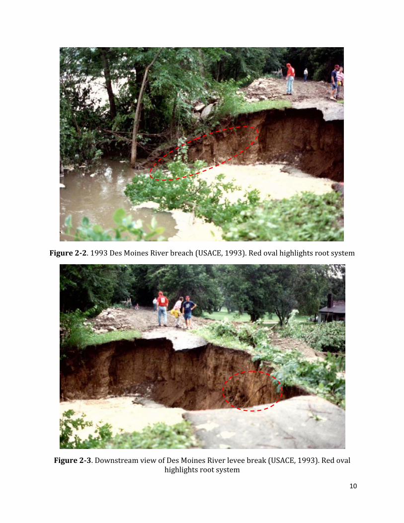
The 1993 flooding in the Mississippi River basin has been catalogued as one of the most severe events in recent years, with a 500-year recurrence interval. A levee breach was reported by a USACE engineer along the Des Moines River in Iowa, north of the town of Des Moines. This site breached once again during a 2008 flood described in subsequent paragraphs.
During the 1993 event, the river was reported to have crested one to two days before the breach occurred, and the breached levee was known for having been constructed with poor compaction, having no under or through seepage remediation measures, having steep slopes under constant erosion from the river and having heavy tree growth (Figure 2-2 and Figure 2-3). Once the waters began to recede, the engineer in charge of the report states that “saturated levee embankments in this reach began a catastrophic failure, with large segments of the levee material slumping into the river. Several massive root balls were observed in the area where the levee failed. Ultimately the levee slumping passed through the levee crown and into the landside of the levee…the heavy tree growth hindered levee inspections and monitoring during the flood fight as well as the remedial constructive measures that were undertaken on the landside of the levee”. The inspection report goes on to state that “the large trees located on these saturated slopes added to the instability of the levee with dead and wind loads contributing to the failure of the levee. While original construction standards on material compaction were inadequate, the failed areas of the levee revealed significant root growth throughout the levee, which likely further facilitated the saturation of the levee embankment when record river stages were occurring”.
This last statement suggests the possibility of saturation of the levee prism was enhanced by seepage paths along the roots, but no direct or specific evidence was provided. The fact that the failure occurred while the waters were receding and progressed from the waterside slope to the landside indicates that these failures could have been related to a rapid drawdown slope instability condition rather than root-aided seepage forces.
10
Figure 2-2. 1993 Des Moines River breach (USACE, 1993). Red oval highlights root system
Figure 2-3. Downstream view of Des Moines River levee break (USACE, 1993). Red oval highlights root system

11
WATER SKI PARK LEVEE DAMAGE, CARBON RIVER, WA
An August 2007 USACE report describes localized waterside levee slope damage near Orting, WA, after an alder tree was toppled in a windstorm and removed surficial soil and erosion armoring from the surface. No measurements of the hole left by the root system were provided, but it appears that the tree lifted a shallow ‘slab’ of soil (Figure 2-4). No levee failure or distress was reported at this site.
PUYALLUP LEVEE DAMAGE, TACOMA, WA
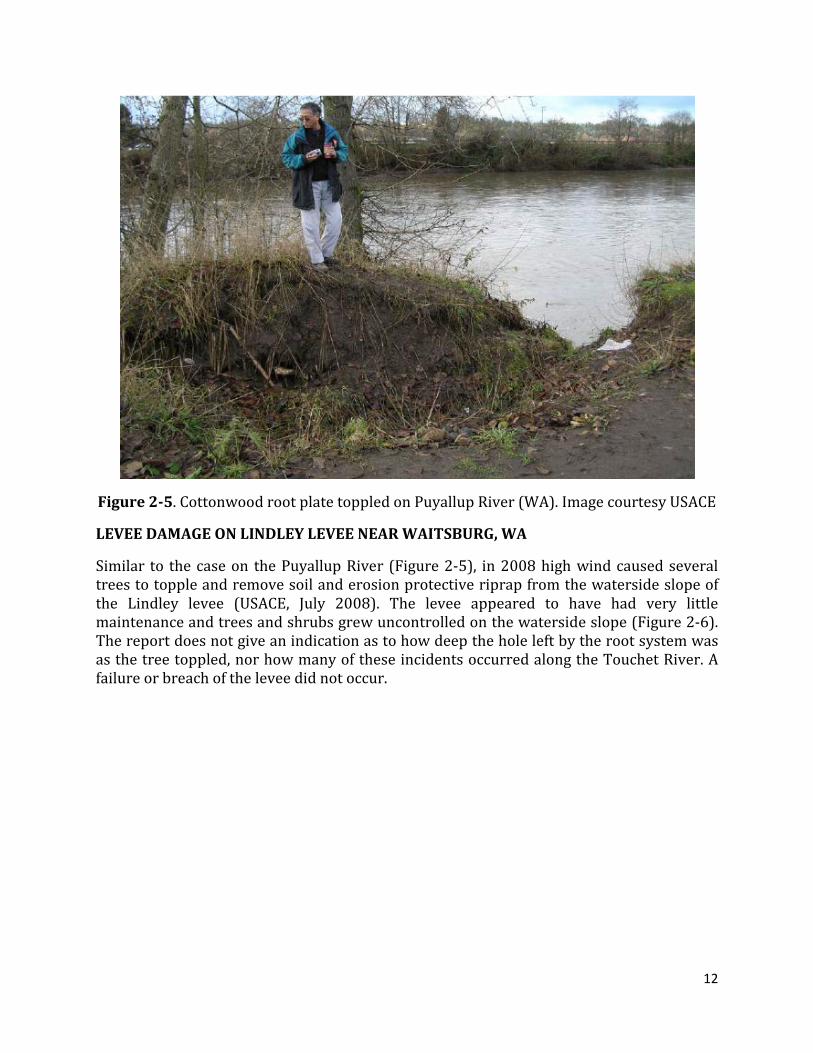
Vegetation-induced levee damage in December 2005 was reported by the USACE on the levee along the Puyallup River near Tacoma, WA. This incident report indicates that soft soil conditions, along with wind loads and river incision contributed to a cottonwood tree toppling over and removing soil from the waterside levee slope (Figure 2-5). No further indication of damage or reconstruction is provided in the incident report, but the report indicates that this type of occurrence is common in the area and toppled trees pull out material adjacent to the levee prism. In this case, the root ball pulled a mass of soil near the waterside toe of the levee.
Figure 2-4. Erosion on waterside slope after tree toppling (USACE, 2007)
12
Figure 2-5. Cottonwood root plate toppled on Puyallup River (WA). Image courtesy USACE
LEVEE DAMAGE ON LINDLEY LEVEE NEAR WAITSBURG, WA
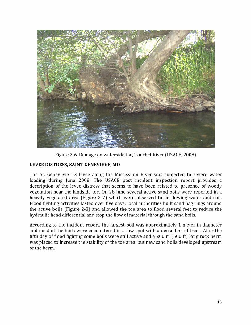
Similar to the case on the Puyallup River (Figure 2-5), in 2008 high wind caused several trees to topple and remove soil and erosion protective riprap from the waterside slope of the Lindley levee (USACE, July 2008). The levee appeared to have had very little maintenance and trees and shrubs grew uncontrolled on the waterside slope (Figure 2-6). The report does not give an indication as to how deep the hole left by the root system was as the tree toppled, nor how many of these incidents occurred along the Touchet River. A failure or breach of the levee did not occur.
13
Figure 2-6. Damage on waterside toe, Touchet River (USACE, 2008)
LEVEE DISTRESS, SAINT GENEVIEVE, MO
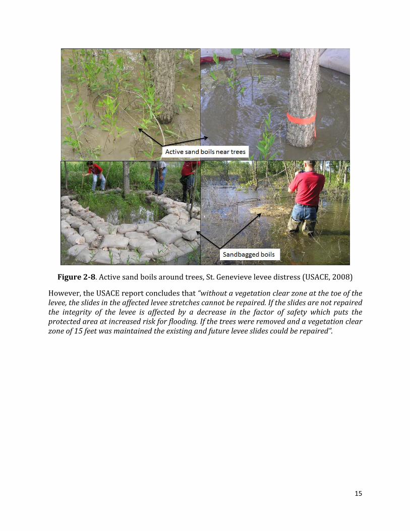
The St. Genevieve #2 levee along the Mississippi River was subjected to severe water loading during June 2008. The USACE post incident inspection report provides a description of the levee distress that seems to have been related to presence of woody vegetation near the landside toe. On 28 June several active sand boils were reported in a heavily vegetated area (Figure 2-7) which were observed to be flowing water and soil. Flood fighting activities lasted over five days; local authorities built sand bag rings around the active boils (Figure 2-8) and allowed the toe area to flood several feet to reduce the hydraulic head differential and stop the flow of material through the sand boils.
According to the incident report, the largest boil was approximately 1 meter in diameter and most of the boils were encountered in a low spot with a dense line of trees. After the fifth day of flood fighting some boils were still active and a 200 m (600 ft) long rock berm was placed to increase the stability of the toe area, but new sand boils developed upstream of the berm.

14
Figure 2-7. View of landside toe area, St. Genevieve levee distress (USACE, 2008)
No information on the levee and foundation conditions are given in the incident report, but the levees in the area along the Mississippi River in Missouri are known for their underseepage susceptibility because of relatively thin landside fine grained soil layers. Several other sand boils were reported during the same flood event in other areas as described by Harder et al., (2009). The incident report concludes that tree roots and associated animal activity (the animal activity was not reported by the USACE) likely attributed to the intensity of the seepage, and that vegetation made it difficult to place the seepage mitigation rings around the boils; however, it seems likely that some boils would have occurred even without the presence of vegetation.
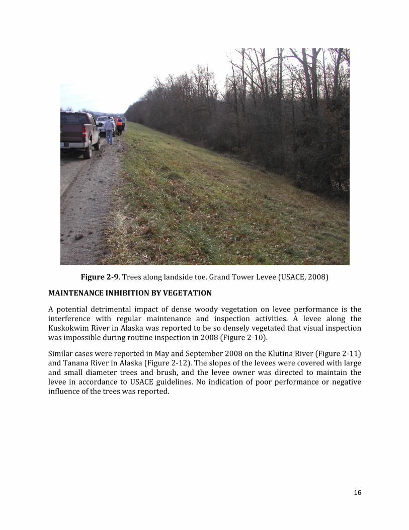
MAINTENANCE AND REPAIR, GRAND TOWER LEVEE, IL
Several shallow landslides along the protected landside toe of the Grand Tower and Degognia levee in Southern Illinois occurred in 2008. At this location, trees were present along long stretches of the landside toe (Figure 2-9). Landslides appear to be a common occurrence in the area and are associated with high-plasticity clays used for embankment material and not necessarily associated with the presence of woody vegetation near the toe of the levee. The report indicates that the trees inhibited maintenance and did not allow for staging materials and equipment for repairs to be performed, but no direct relation to the observed failure was given.
15
Figure 2-8. Active sand boils around trees, St. Genevieve levee distress (USACE, 2008)
However, the USACE report concludes that “without a vegetation clear zone at the toe of the levee, the slides in the affected levee stretches cannot be repaired. If the slides are not repaired the integrity of the levee is affected by a decrease in the factor of safety which puts the protected area at increased risk for flooding. If the trees were removed and a vegetation clear zone of 15 feet was maintained the existing and future levee slides could be repaired”.
16
Figure 2-9. Trees along landside toe. Grand Tower Levee (USACE, 2008)
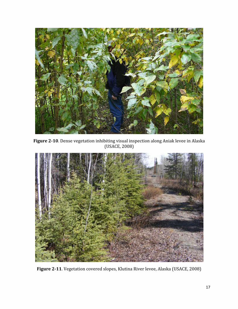
MAINTENANCE INHIBITION BY VEGETATION
A potential detrimental impact of dense woody vegetation on levee performance is the interference with regular maintenance and inspection activities. A levee along the Kuskokwim River in Alaska was reported to be so densely vegetated that visual inspection was impossible during routine inspection in 2008 (Figure 2-10).
Similar cases were reported in May and September 2008 on the Klutina River (Figure 2-11) and Tanana River in Alaska (Figure 2-12). The slopes of the levees were covered with large and small diameter trees and brush, and the levee owner was directed to maintain the levee in accordance to USACE guidelines. No indication of poor performance or negative influence of the trees was reported.
17
Figure 2-10. Dense vegetation inhibiting visual inspection along Aniak levee in Alaska (USACE, 2008)
Figure 2-11. Vegetation covered slopes, Klutina River levee, Alaska (USACE, 2008)
18
Figure 2-12. Vegetation covered slopes, Tanana River levee, Alaska (USACE, 2008)
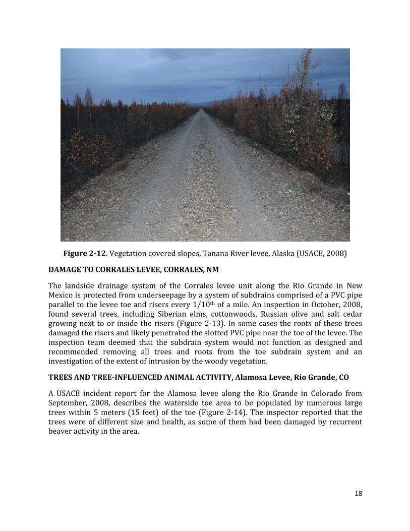
DAMAGE TO CORRALES LEVEE, CORRALES, NM
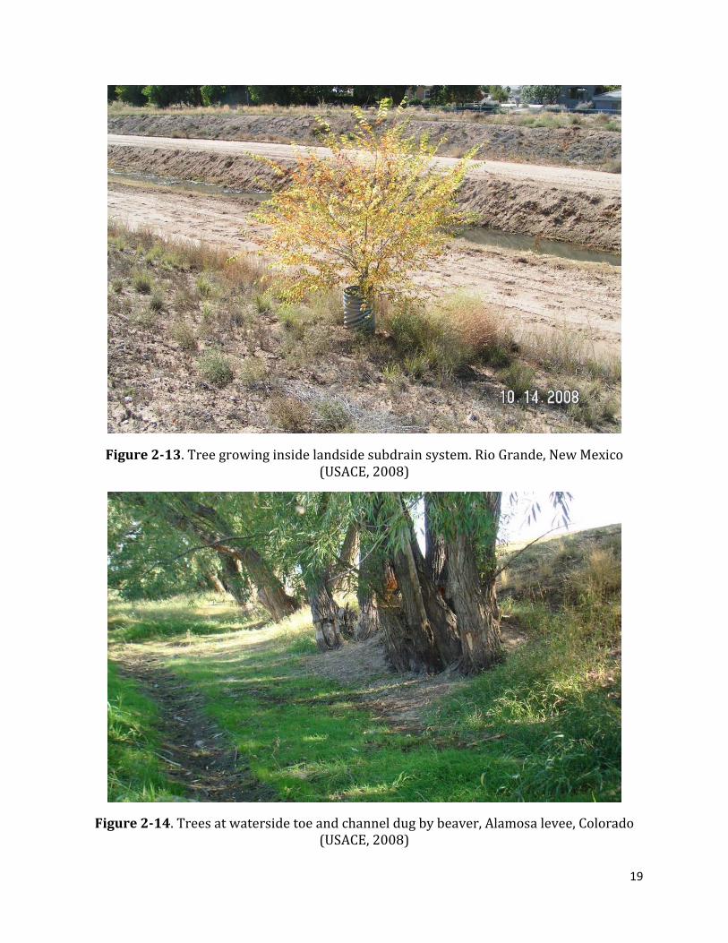
The landside drainage system of the Corrales levee unit along the Rio Grande in New Mexico is protected from underseepage by a system of subdrains comprised of a PVC pipe parallel to the levee toe and risers every 1/10th of a mile. An inspection in October, 2008, found several trees, including Siberian elms, cottonwoods, Russian olive and salt cedar growing next to or inside the risers (Figure 2-13). In some cases the roots of these trees damaged the risers and likely penetrated the slotted PVC pipe near the toe of the levee. The inspection team deemed that the subdrain system would not function as designed and recommended removing all trees and roots from the toe subdrain system and an investigation of the extent of intrusion by the woody vegetation.
TREES AND TREE-INFLUENCED ANIMAL ACTIVITY, Alamosa Levee, Rio Grande, CO
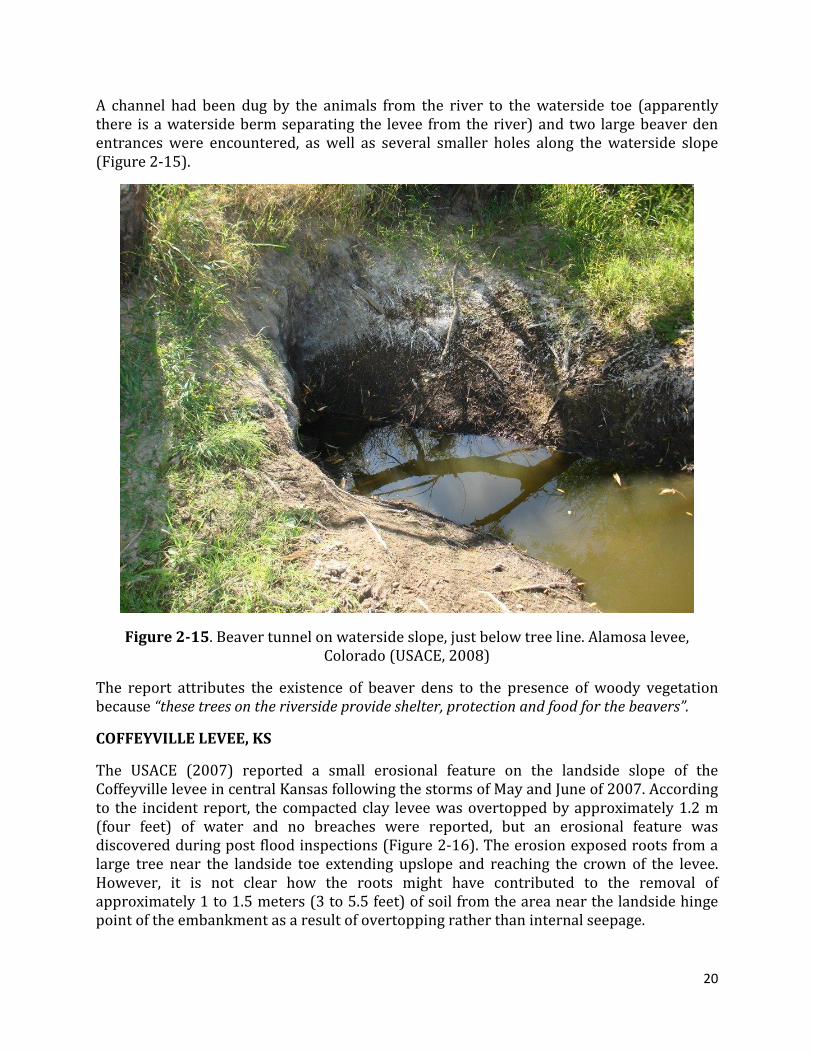
A USACE incident report for the Alamosa levee along the Rio Grande in Colorado from September, 2008, describes the waterside toe area to be populated by numerous large trees within 5 meters (15 feet) of the toe (Figure 2-14). The inspector reported that the trees were of different size and health, as some of them had been damaged by recurrent beaver activity in the area.
19
Figure 2-13. Tree growing inside landside subdrain system. Rio Grande, New Mexico (USACE, 2008)
Figure 2-14. Trees at waterside toe and channel dug by beaver, Alamosa levee, Colorado (USACE, 2008)
20
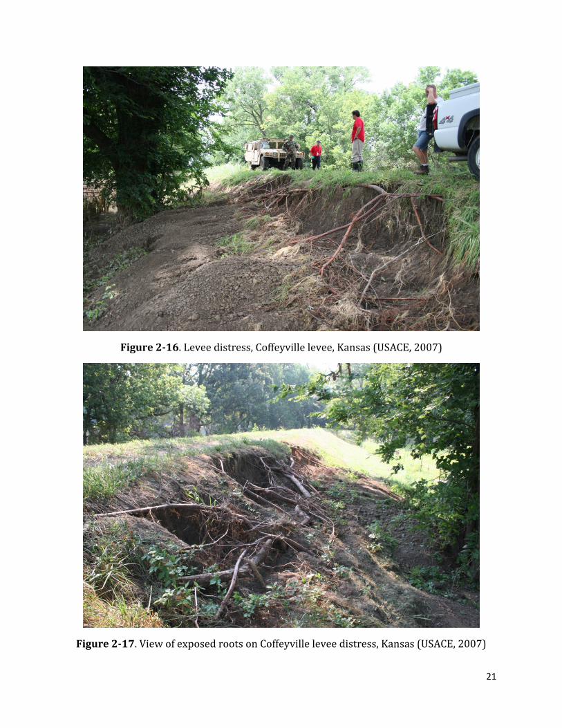
A channel had been dug by the animals from the river to the waterside toe (apparently there is a waterside berm separating the levee from the river) and two large beaver den entrances were encountered, as well as several smaller holes along the waterside slope (Figure 2-15).
Figure 2-15. Beaver tunnel on waterside slope, just below tree line. Alamosa levee, Colorado (USACE, 2008)
The report attributes the existence of beaver dens to the presence of woody vegetation because “these trees on the riverside provide shelter, protection and food for the beavers”.
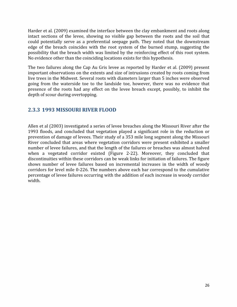
COFFEYVILLE LEVEE, KS
The USACE (2007) reported a small erosional feature on the landside slope of the Coffeyville levee in central Kansas following the storms of May and June of 2007. According to the incident report, the compacted clay levee was overtopped by approximately 1.2 m (four feet) of water and no breaches were reported, but an erosional feature was discovered during post flood inspections (Figure 2-16). The erosion exposed roots from a large tree near the landside toe extending upslope and reaching the crown of the levee. However, it is not clear how the roots might have contributed to the removal of approximately 1 to 1.5 meters (3 to 5.5 feet) of soil from the area near the landside hinge point of the embankment as a result of overtopping rather than internal seepage.
21
Figure 2-16. Levee distress, Coffeyville levee, Kansas (USACE, 2007)
Figure 2-17. View of exposed roots on Coffeyville levee distress, Kansas (USACE, 2007)

22
The images show that the erosional feature roughly coincides with the zone of densest roots (Figure 2-17). However, there is no information on soil properties and their variability along the levee.
2.3 EVALUATIONS OF LEVEE DISTRESS AND LEVEE BREACHES BY OTHERS
2.3.1 EAST SAINT LOUIS LEVEE SYSTEM, JUNE 2008 FLOOD
Harder et al., (2009) performed inspections of the levee distress and breaches during the June 2008 floods in the Midwestern United States. Twenty-two breaches were reported, mainly due to overtopping along levee systems spanning the states of Iowa, Illinois and Missouri. The sites studied were selected because of the presence of trees and/or animal burrowing activity. Their descriptions, conclusions and findings are summarized on this section.
The distress site is located on the left descending bank of the Mississippi River across from St. Louis (MO). The levee is approximately 8 meters (25 ft) high with slopes of 3:1 (horizontal to vertical). Two berms and a system of relief wells were observed by Harder et al. (2009), indicating a known history of seepage and stability issues for this levee reach.
Animal burrows were observed near the crest and on the lower part of the landside slope, and several trees that were apparently uprooted some time before the 2008 floods were also observed. The root balls (Figure 2-18) were still in evidence showing that there was apparently disturbed ground near the landside toe and most likely including roots in the soil.

23
Figure 2-18. Uprooted trees and root balls at the East St. Louis site. (Harder et al., 2009)
Sand boils (Figure 2-19) were observed between the relief wells, in some instances as close as 20 ft from a well, and the occurrence of the boils appeared to coincide with the ground disturbance produced by the removed trees. A previous flood event in 1993 did not produce any sand boils, despite the fact that recorded river levels were about 11 ft higher than the 2008 flood. The report by Harder et al. (2009) indicates that improper tree removal might have disturbed the top soil enough to allow the triggering of the observed levee distress in the form of sand boils.
The reported levee distress at this site seems to have been exacerbated by anthropogenic activities rather than by the presence of woody vegetation detrimental to the performance of the levee. The fact that during previous flood events with significantly higher hydraulic loading the existing remediation measures performed adequately (relief wells, stability and seepage berms) indicates that the problems presented on this site were likely a direct consequence of the ground disturbance generated by the removal of the tree and root balls near the landside toe. The report does not provide information on the presence or absence of a landside fine-grained blanket, but it is likely that the removal of root balls had damaged the blanket or created discontinuities that allowed the formation of sand boils.

24
Figure 2-19. Sand boil at East St. Louis site (Harder et al., 2009)
2.3.2 CAP AU GRIS LEVEE BREACHES, MISSISSIPPI RIVER, WINFIELD, MO
Harder et al. (2009) describe two breaches that washed away the levee at low spots along the Cap Au Gris levee alignment, coincident with road access or structure encroachments. The breaches occurred along a levee near Winfield (MO) along the Mississippi River.
Post failure reconnaissance of the eroded embankments indicated the presence of several large (5 to 7 inches in diameter) live roots, extending across most of the embankment width. The first breach (Cap Au Gris – Site 1 in Harder et al. 2009) of a relatively low levee (9 feet high) with slopes between 3:1 and 4:1 (Figure 2-20) developed as water overtopped and concentrated on a low spot where a road access joined the levee crown. A witness account described no (through or under) seepage shortly before the failure, therefore the failure was likely due to concentrated overtopping that washed away the levee material and resulted in a 30 ft wide breach extending down to the foundation.
The roots encountered in the eroded area ranged from less than 1 inch to about 5 inches in diameter (Figure 2-21), and seemed to originate from two stumps encountered near the waterside toe of the eroded levee with diameters of 3 and 4 feet. The larger roots appear to have traveled distances larger than 50 ft from the stump towards the embankment. A smaller stump and a live cottonwood were also present in the vicinity of the breach.

25
Figure 2-20. Cap Au Gris - Site 1 (Harder et al., 2009)
Figure 2-21. View of eroded levee at Cap Au Gris - Site 1 (Harder et al., 2009)
A second breach in the area (Cap Au Gris – Site 2), located approximately one mile downstream of Site 1 was also triggered by concentrated overtopping around a low spot on the levee crown. This breach was approximately 105 m (350 ft) wide and destroyed several houses. Post failure reconnaissance also noted a large number of roots coming from live trees located at or near the waterside toe and a single burned stump near the landside toe.
26
Harder et al. (2009) examined the interface between the clay embankment and roots along intact sections of the levee, showing no visible gap between the roots and the soil that could potentially serve as a preferential seepage path. They noted that the downstream edge of the breach coincides with the root system of the burned stump, suggesting the possibility that the breach width was limited by the reinforcing effect of this root system. No evidence other than the coinciding locations exists for this hypothesis.
The two failures along the Cap Au Gris levee as reported by Harder et al. (2009) present important observations on the extents and size of intrusions created by roots coming from live trees in the Midwest. Several roots with diameters larger than 5 inches were observed going from the waterside toe to the landside toe, however, there was no evidence that presence of the roots had any effect on the levee breach except, possibly, to inhibit the depth of scour during overtopping.
2.3.3 1993 MISSOURI RIVER FLOOD
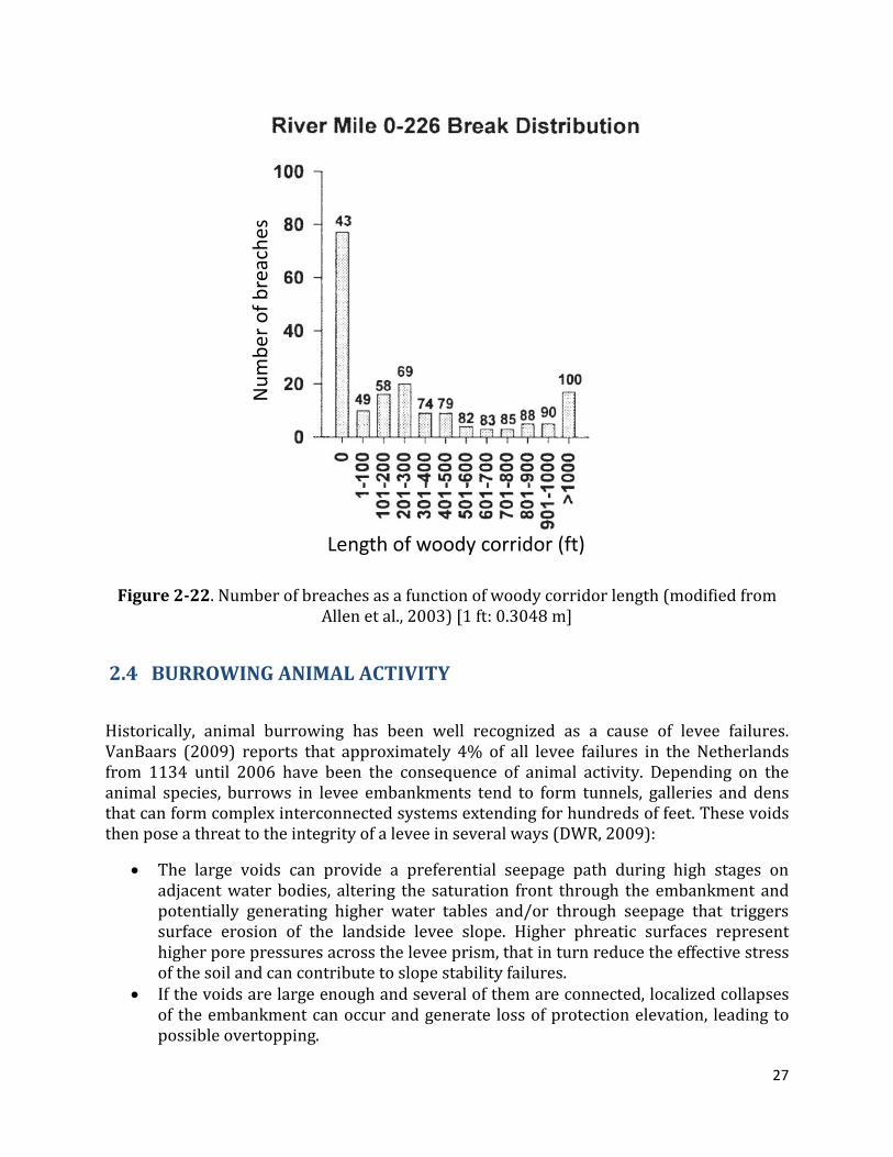
Allen et al (2003) investigated a series of levee breaches along the Missouri River after the 1993 floods, and concluded that vegetation played a significant role in the reduction or prevention of damage of levees. Their study of a 353 mile long segment along the Missouri River concluded that areas where vegetation corridors were present exhibited a smaller number of levee failures, and that the length of the failures or breaches was almost halved when a vegetated corridor existed (Figure 2-22). Moreover, they concluded that discontinuities within these corridors can be weak links for initiation of failures. The figure shows number of levee failures based on incremental increases in the width of woody corridors for level mile 0-226. The numbers above each bar correspond to the cumulative percentage of levee failures occurring with the addition of each increase in woody corridor width.
27
Num
bero
f bre
ache
s
Length of woody corridor (ft)
Figure 2-22. Number of breaches as a function of woody corridor length (modified from Allen et al., 2003) [1 ft: 0.3048 m]
2.4 BURROWING ANIMAL ACTIVITY
Historically, animal burrowing has been well recognized as a cause of levee failures. VanBaars (2009) reports that approximately 4% of all levee failures in the Netherlands from 1134 until 2006 have been the consequence of animal activity. Depending on the animal species, burrows in levee embankments tend to form tunnels, galleries and dens that can form complex interconnected systems extending for hundreds of feet. These voids then pose a threat to the integrity of a levee in several ways (DWR, 2009):
• The large voids can provide a preferential seepage path during high stages on adjacent water bodies, altering the saturation front through the embankment and potentially generating higher water tables and/or through seepage that triggers surface erosion of the landside levee slope. Higher phreatic surfaces represent higher pore pressures across the levee prism, that in turn reduce the effective stress of the soil and can contribute to slope stability failures.
• If the voids are large enough and several of them are connected, localized collapses of the embankment can occur and generate loss of protection elevation, leading to possible overtopping.

28
• If the embankment is composed of erodible materials, large burrow systems that extend from one side to the other of the levee can become conduits for piping and rapid erosion of the levee materials.
For dams, which share some characteristics with levees, FEMA (2005) identifies potential risks from animal burrowing as (1) hydraulic alteration, (2) structural integrity losses, and (3) surface erosion. Hydraulic alteration (Figure 2-23) is basically a distortion of the phreatic surface established through the embankment, as burrow dens and complexes located on the waterside can allow water from the waterside to enter inner portions of the embankment with no loss of hydraulic potential. If the burrows are on the protected side (landside), burrows that extend below the phreatic surface can concentrate the flow lines and potentially lead to piping. This phenomenon is most often cited as the greatest concern because it is progressive and can rapidly lead to failure (FEMA, 2005). Structural integrity losses occur when a large number of burrows or dens collapse, generating a localized loss of freeboard or flood protection elevation (Figure 2-23) or slope instability in the vicinity of the collapse. Finally, surface erosion by the downslope biogenic movement of soil ejected from the animal burrows eliminates vegetal cover that provides erosion protection.
Figure 2-23. Effects of animal burrows in embankments
Current efforts to quantify the extents of animal burrow-induced damage to levees in California are being undertaken as part of the California Levee Vegetation Research Program and by the California DWR. In 2009 DWR conducted an Animal Burrow Hole Persistence Study on Sacramento area levees using data from biannual inspections spanning twenty four years (DWR, 2009). The variable employed to measure the activity of mammals was the cumulative occurrence of documented burrows over time, which suggests animal persistence in a given levee reach. Repeated reports were then related to a higher degree of structural damage in comparison with sites that had none or few reported instances of animal intrusions. The study categorizes the level of activity using statistical analysis, and assigned low, medium and high persistence to levee miles within the lower, middle and upper third of the statistical distribution. Of the 1,567 miles analyzed by DWR, 543 miles (35%) was classified as having a high persistence of animal activity data with eight or more recurrent events, 382 miles (24%) as having medium persistence (four to
29
seven recurrences), 350 miles (22%) had low persistence (one to three recurrences), and the remaining 292 miles were considered to have no recurrences or no available data to classify them.
The presence and recurrence of animal intrusions in levees are a direct function of: available food sources, levee material, vegetation and maintenance practices. The latter is of particular importance as local districts generally have different funding depending on the characteristics of their protected basin (e.g. urban vs. non-urban levees). Therefore, each district applies animal control and vegetation management practices that are deemed affordable and specific to the habitats of the burrowing species. Typical animal control measures consist of cement-bentonite grouting, trapping, baiting with zinc phosphide, fumigation, anticoagulant baits, carbon monoxide injections, biological control, contraception, and shooting (Ventura County Watershed Protection District, 2006).
Typical burrowing rodent species in levees are Botta’s Pocket Gopher (Thomomys bottae) known for creating shallow networks of burrows parallel to the ground surface (4 to 6 cm in diameter). Gophers have been reported to burrow through irrigation ditch embankments (Dixon, 1922) and are commonly found in North and Central America. This species is known for displacing as much soil as 18 m3/ha per year (Bayoumi and Meguid, 2011). The California vole (Microtus californicus) is another small rodent that tends to remain in the upper foot of soil and dig holes similar to gophers, generally from 3 to 5 cm in diameter.
California ground squirrels (Otospermophilus beecheyi) are a common burrowing mammal and tend to dig relatively large burrows (6-15 cm in diameter), averaging 10 cm in diameter and between one and ten meters in length. The longest squirrel burrow on record had a total length of 222 meters (728 ft) with 33 openings, indicating that despite their relatively small size, squirrels can burrow completely through a levee section (Bayoumi and Meguid, 2011). Squirrel burrow complexes can become preferential paths for seepage and carry floodwaters and sediment and in general provide pathways for internal erosion of levee embankments. Van Vuren (2011) indicates that the presence of woody vegetation has a negative influence on the occurrence of squirrel population.
Larger species such as beavers (Castor Canadensis), muskrats (Ondatra zibethicus) and certain carnivores (coyotes, gray foxes and skunks) may excavate significantly larger burrows that can result in collapse of alevee embankment. Beavers obstruct waterways by constructing dams; their dens generally extend from several feet below the waterline toward the landside. Dens tend to be between 0.5 and 3 meters in diameter and extend several meters into a levee embankment. Two recent levee failures in the United States have been attributed to beaver intrusions (Clevenger, 1999): one in Southern Hinds County (MS), where “a levee almost breached within a few hours from the first spotted landside leakage. Upon inspection by the division of dam safety in the state of Mississippi, beaver dens and tunnels were exposed and the levee segment appeared to be badly damaged”. The second failure was reported in DeSoto County (MS) and involved a large beaver den near a populated area (Clevenger, 1999).

30
Muskrats are another large burrowing species known for creating large burrows and extensive damage to levees and earthen dams. Typical muskrat burrows are between 13 and 15 cm in diameter and can extend between three and fifteen meters (Bayoumi and Meguid, 2011), converging in one or several nest chambers above the water level. Muskrat burrows have been classified as a threat to the security of dike and levee systems in the Netherlands (Van Troostwijk, 1978; Kadlec et al., 2007) because of their large size, which similar to beaver dens, can trigger collapses of large portions of a levee embankment. Other species such as marmots, nutria and armadillos have also been linked to levee damage.
In terms of potential damage to levees, gophers and voles are considered to have little influence as their burrows tend to be shallow and parallel to the levee face; therefore, their effects are more of a maintenance issue as soil is transported downslope and the potential for collapse of the embankment is low. California ground squirrels dig larger, deeper and longer burrow complexes that can threaten levee performance (Daar et al. 1984). These three species were the focus of a recent study by Van Vuren et al., (2011). He performed a statistical study of habitat association for mammal intrusions on levees in California, by analyzing data collected along 166 50-ft long levee segments. His team counted 33,678 gopher burrows and 5,705 squirrel burrows. Larger species were found to be too few for the statistical analysis (16 large carnivore holes). However, a single large beaver intrusion might be large enough to produce a collapse of the embankment.
The following section describes several well-documented animal intrusion case histories that have resulted in extensive damage to levees in order to set the stage for the experimental program performed in this study.
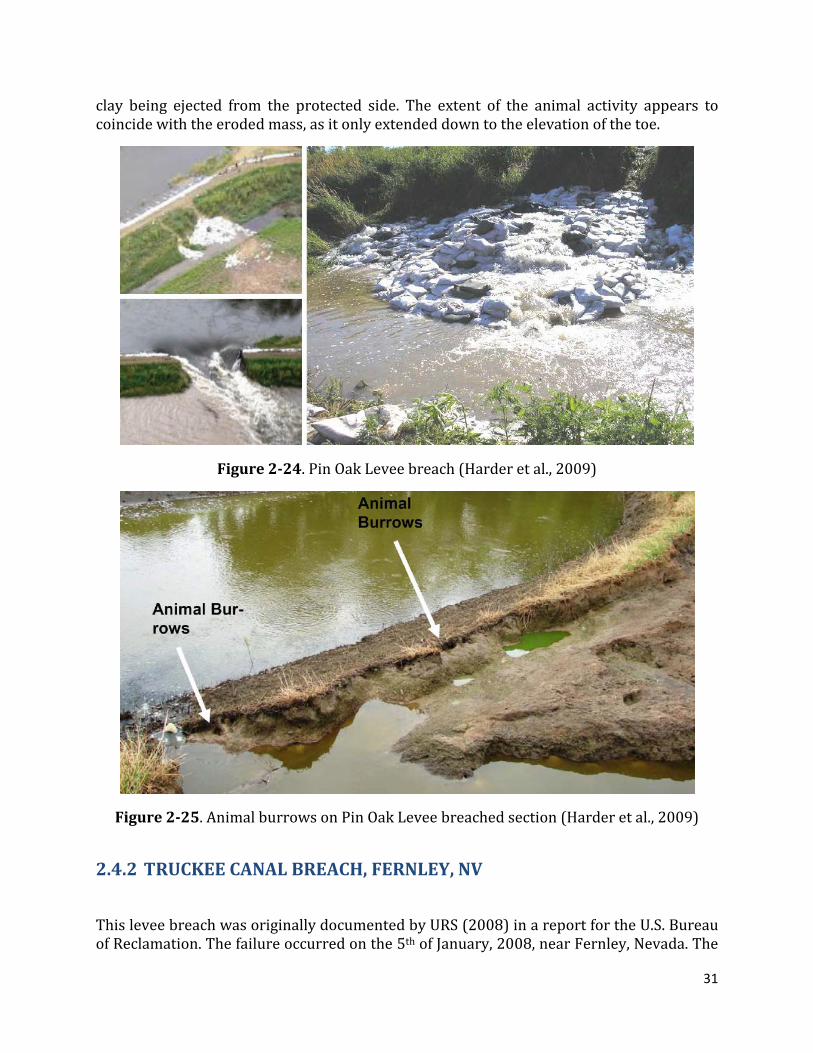
2.4.1 PIN OAK LEVEE BREACH
The Pin Oak levee protects the city of Winfield, MO, from the backwaters of the Mississippi River and has a history of poor performance, as two breaches had previously occurred at this site during the 1993 floods (Harder et al., 2009).
During the 2008 flood several landside slope failures were observed, as well as through seepage (flow of water through the levee embankment exiting on the landside slope) at two locations. A breach occurred at one of the through-seepage sites on 27 June, 2008 (Figure 2-24). The heaviest seepage was observed near the landside toe where a landside ditch parallels the toe. Sandbags were placed around the heavy seepage area (Figure 2-25) in an attempt to minimize the seepage quantities but the through seepage ‘broke through’ the levee material above the top of the sandbags. Subsequent emergency response included the construction of a larger sandbag ring and placement of a tarp on the waterside slope; all to no avail as this levee breached several hours later.
The post-breach reconnaissance by Harder et al. (2009) reports several 5 to 8 cm (2 to 3 inch) diameter rodent holes in the vicinity of the breach along the waterside slope, extending from the toe to a few feet below midslope. Witness accounts report the presence of muskrats diving into the area where the tarp was placed during the flood and chunks of
31
clay being ejected from the protected side. The extent of the animal activity appears to coincide with the eroded mass, as it only extended down to the elevation of the toe.
Figure 2-24. Pin Oak Levee breach (Harder et al., 2009)
Figure 2-25. Animal burrows on Pin Oak Levee breached section (Harder et al., 2009)
2.4.2 TRUCKEE CANAL BREACH, FERNLEY, NV
This levee breach was originally documented by URS (2008) in a report for the U.S. Bureau of Reclamation. The failure occurred on the 5th of January, 2008, near Fernley, Nevada. The
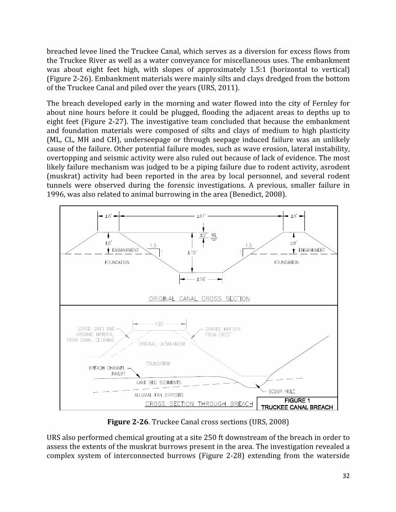
32
breached levee lined the Truckee Canal, which serves as a diversion for excess flows from the Truckee River as well as a water conveyance for miscellaneous uses. The embankment was about eight feet high, with slopes of approximately 1.5:1 (horizontal to vertical) (Figure 2-26). Embankment materials were mainly silts and clays dredged from the bottom of the Truckee Canal and piled over the years (URS, 2011).
The breach developed early in the morning and water flowed into the city of Fernley for about nine hours before it could be plugged, flooding the adjacent areas to depths up to eight feet (Figure 2-27). The investigative team concluded that because the embankment and foundation materials were composed of silts and clays of medium to high plasticity (ML, CL, MH and CH), underseepage or through seepage induced failure was an unlikely cause of the failure. Other potential failure modes, such as wave erosion, lateral instability, overtopping and seismic activity were also ruled out because of lack of evidence. The most likely failure mechanism was judged to be a piping failure due to rodent activity, asrodent (muskrat) activity had been reported in the area by local personnel, and several rodent tunnels were observed during the forensic investigations. A previous, smaller failure in 1996, was also related to animal burrowing in the area (Benedict, 2008).
Figure 2-26. Truckee Canal cross sections (URS, 2008)
URS also performed chemical grouting at a site 250 ft downstream of the breach in order to assess the extents of the muskrat burrows present in the area. The investigation revealed a complex system of interconnected burrows (Figure 2-28) extending from the waterside
33
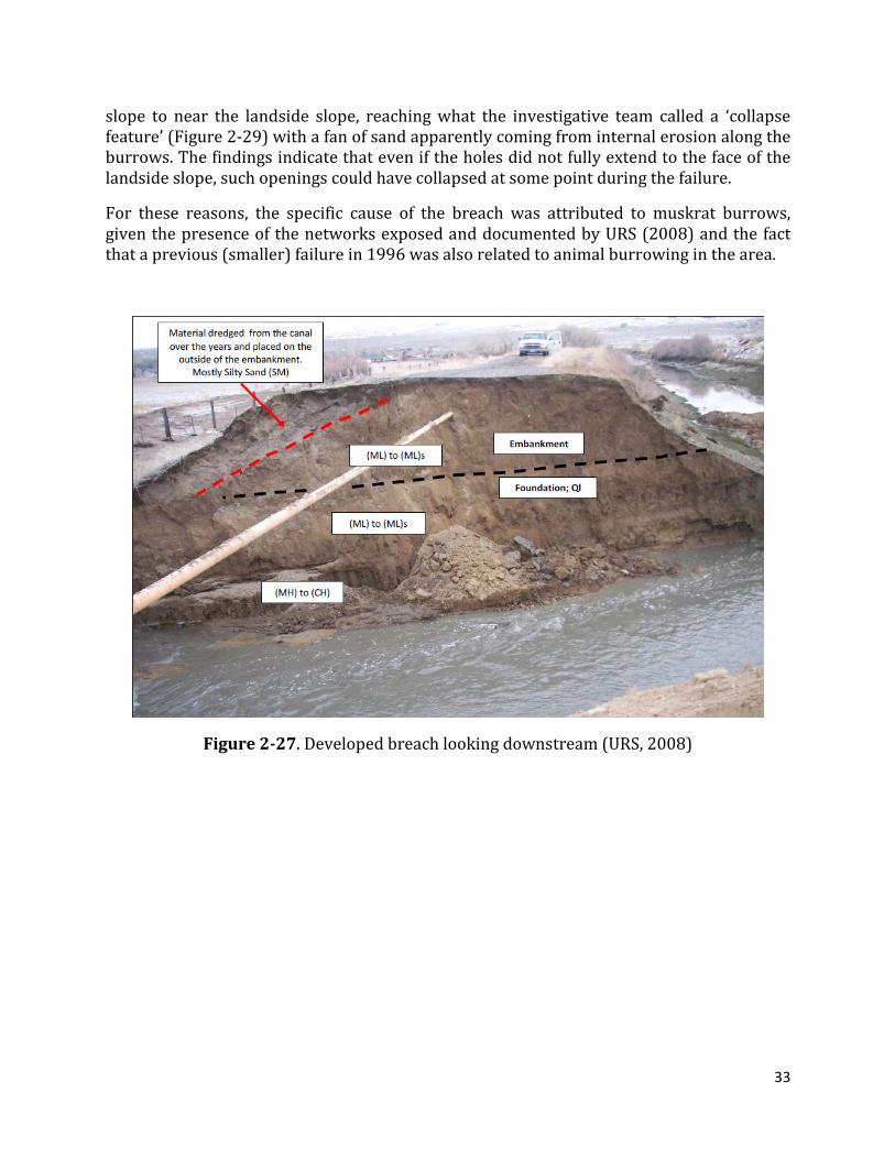
slope to near the landside slope, reaching what the investigative team called a ‘collapse feature’ (Figure 2-29) with a fan of sand apparently coming from internal erosion along the burrows. The findings indicate that even if the holes did not fully extend to the face of the landside slope, such openings could have collapsed at some point during the failure.
For these reasons, the specific cause of the breach was attributed to muskrat burrows, given the presence of the networks exposed and documented by URS (2008) and the fact that a previous (smaller) failure in 1996 was also related to animal burrowing in the area.
Figure 2-27. Developed breach looking downstream (URS, 2008)

34
Figure 2-28. Exposed grouted burrows 250 ft downstream of breached site (URS, 2008)
Figure 2-29. Collapse feature at the landside edge of burrow complex (URS, 2008)
2.4.3 MEDFORD ISLAND LEVEE, CA
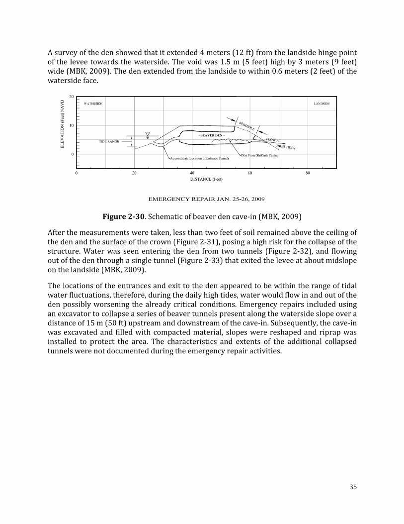
On 24 January 2009 a cave-in was reported on the southern end of Medford Island in theh Sacramento-San Joaquin Delta, exposing a large beaver den. The levee is approximately 2.5 to 3 meters (8 to 10 ft) high and 6 meters (20 ft) wide at its crown (Figure 2-30).
35
A survey of the den showed that it extended 4 meters (12 ft) from the landside hinge point of the levee towards the waterside. The void was 1.5 m (5 feet) high by 3 meters (9 feet) wide (MBK, 2009). The den extended from the landside to within 0.6 meters (2 feet) of the waterside face.
Figure 2-30. Schematic of beaver den cave-in (MBK, 2009)
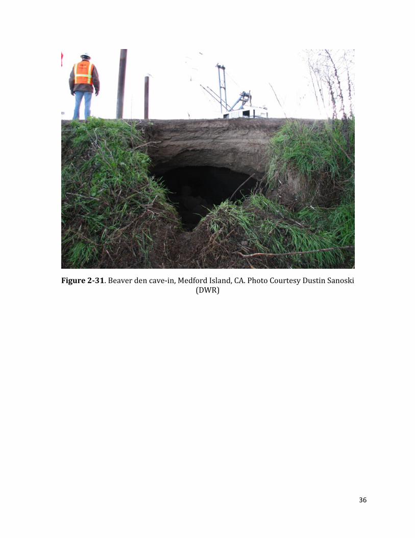
After the measurements were taken, less than two feet of soil remained above the ceiling of the den and the surface of the crown (Figure 2-31), posing a high risk for the collapse of the structure. Water was seen entering the den from two tunnels (Figure 2-32), and flowing out of the den through a single tunnel (Figure 2-33) that exited the levee at about midslope on the landside (MBK, 2009).
The locations of the entrances and exit to the den appeared to be within the range of tidal water fluctuations, therefore, during the daily high tides, water would flow in and out of the den possibly worsening the already critical conditions. Emergency repairs included using an excavator to collapse a series of beaver tunnels present along the waterside slope over a distance of 15 m (50 ft) upstream and downstream of the cave-in. Subsequently, the cave-in was excavated and filled with compacted material, slopes were reshaped and riprap was installed to protect the area. The characteristics and extents of the additional collapsed tunnels were not documented during the emergency repair activities.
36
Figure 2-31. Beaver den cave-in, Medford Island, CA. Photo Courtesy Dustin Sanoski (DWR)

37
Figure 2-32. Internal view of the den showing access tunnels from the waterside (MBK, 2009)
Figure 2-33. View of the landside cave-in from the levee crown (MBK, 2009)

38
2.4.4 AMERICAN RIVER FLOOD CONTROL DISTRICT, SACRAMENTO, CA
Several recent instances of beaver intrusions have been reported by inspection personnel from the American River Flood Control District (ARFCD) in Sacramento (CA). Repairs were necessary in at least eight locations along the 40 miles of levees maintained by this flood control district between 2004 and 2011. Figure 2-34 shows a collapse near the waterside toe of the levee at Arcade Creek (north of Sacramento) found in June of 2004. The damage was spotted during one of the levee inspections, extending from the waterside edge of a 5 m (15 ft) wide berm approximately 4 to 5 meters towards the toe of the levee. The intrusion was between 30 and 35 cm in diameter (12 to 14 inches) at its entrance, which coincided with the root system of a tree. The burrow extended between 1 and 2 meters below the elevation of the berm.
Similar beaver activity has been recurrent along Arcade Creek (Figure 2-35 through Figure 2-42). The beaver tunnels and dens are generally found in the waterside berm and sometimes extend to the waterside toe of the levee and beyond. However, when there are prolonged periods of high water some of these animals burrow above the berm and into the levee (Figure 2-42), or when no berm exists between the canal and the levee these animals dig directly into the levee embankment (Figure 2-31 and Figure 2-36) creating potential for collapses, internal erosion and accelerated saturation of the levee under high water.
Waterside toe~5 m
Burrow entrancebelow tree root
~0.3 m
Figure 2-34. Waterside berm collapse at Arcade Creek levee. Images courtesy of Richard Marck (ARFCD)
39
(a) Entrance to burrow (b) Excavated burrow
(c) Close up of tunnel entrance~3 m
Waterside toe
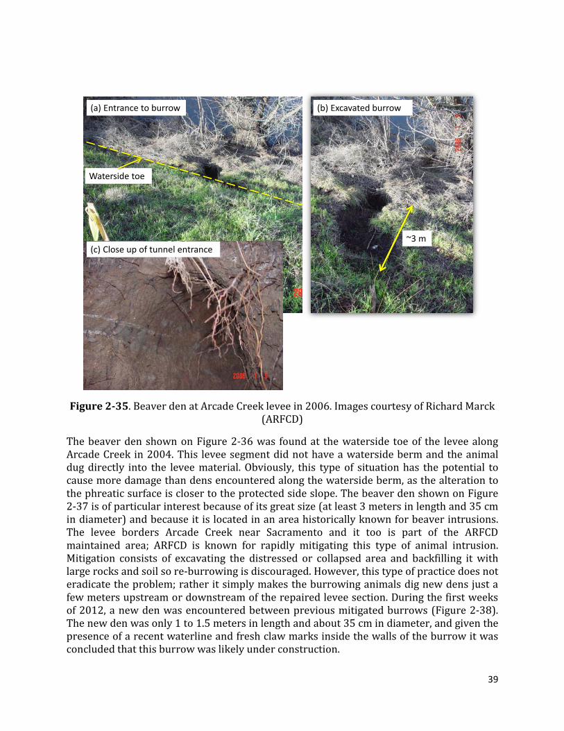
Figure 2-35. Beaver den at Arcade Creek levee in 2006. Images courtesy of Richard Marck (ARFCD)
The beaver den shown on Figure 2-36 was found at the waterside toe of the levee along Arcade Creek in 2004. This levee segment did not have a waterside berm and the animal dug directly into the levee material. Obviously, this type of situation has the potential to cause more damage than dens encountered along the waterside berm, as the alteration to the phreatic surface is closer to the protected side slope. The beaver den shown on Figure 2-37 is of particular interest because of its great size (at least 3 meters in length and 35 cm in diameter) and because it is located in an area historically known for beaver intrusions. The levee borders Arcade Creek near Sacramento and it too is part of the ARFCD maintained area; ARFCD is known for rapidly mitigating this type of animal intrusion. Mitigation consists of excavating the distressed or collapsed area and backfilling it with large rocks and soil so re-burrowing is discouraged. However, this type of practice does not eradicate the problem; rather it simply makes the burrowing animals dig new dens just a few meters upstream or downstream of the repaired levee section. During the first weeks of 2012, a new den was encountered between previous mitigated burrows (Figure 2-38). The new den was only 1 to 1.5 meters in length and about 35 cm in diameter, and given the presence of a recent waterline and fresh claw marks inside the walls of the burrow it was concluded that this burrow was likely under construction.

40
Figure 2-36. Beaver hole at waterside toe in 2004. Image courtesy of Richard Marck (ARFCD)
Nov 2004Waterside toe
3 m
Figure 2-37. Beaver den at Arcade Creek. Images courtesy of Richard Marck (ARFCD)
41
Beaver dam
New burrow
2004 repairs
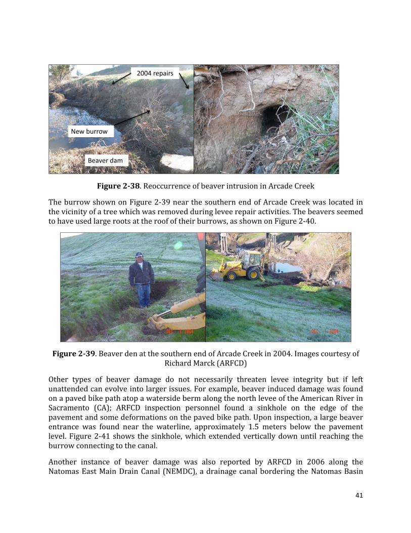
Figure 2-38. Reoccurrence of beaver intrusion in Arcade Creek
The burrow shown on Figure 2-39 near the southern end of Arcade Creek was located in the vicinity of a tree which was removed during levee repair activities. The beavers seemed to have used large roots at the roof of their burrows, as shown on Figure 2-40.
Figure 2-39. Beaver den at the southern end of Arcade Creek in 2004. Images courtesy of Richard Marck (ARFCD)
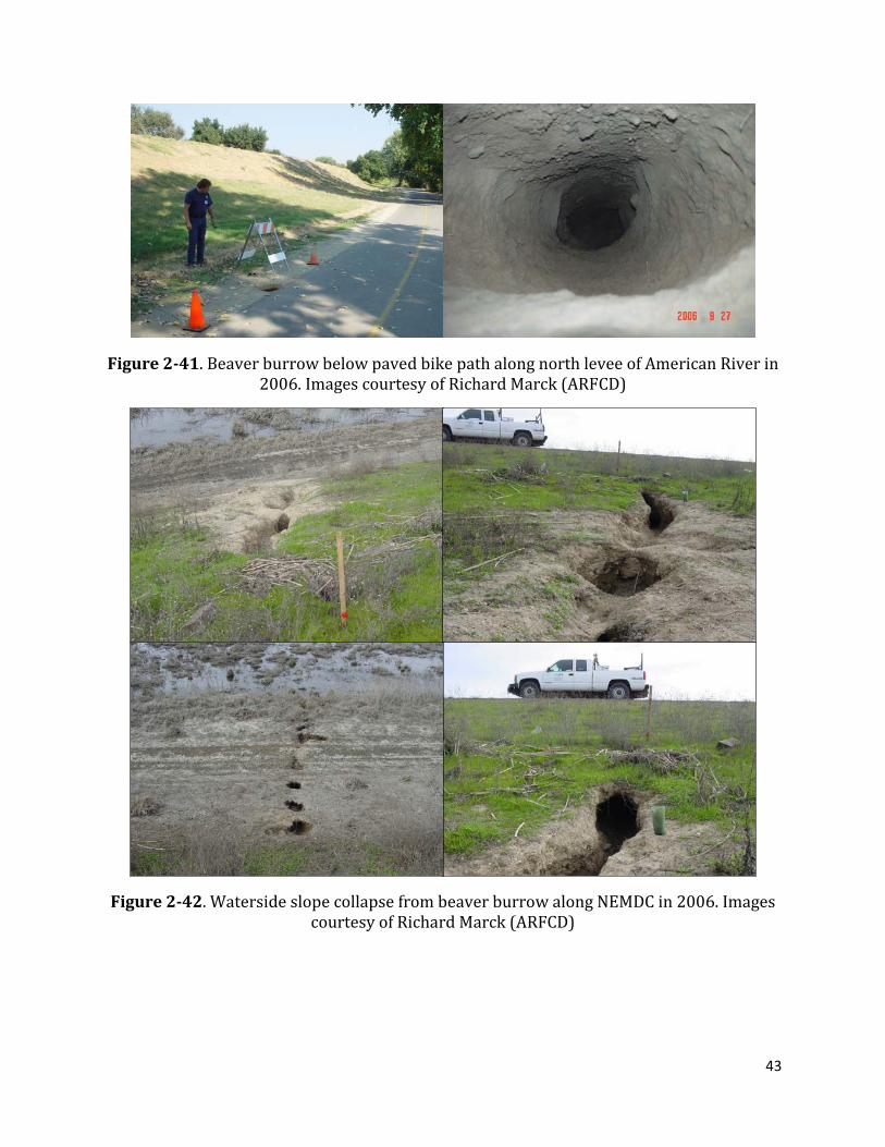
Other types of beaver damage do not necessarily threaten levee integrity but if left unattended can evolve into larger issues. For example, beaver induced damage was found on a paved bike path atop a waterside berm along the north levee of the American River in Sacramento (CA); ARFCD inspection personnel found a sinkhole on the edge of the pavement and some deformations on the paved bike path. Upon inspection, a large beaver entrance was found near the waterline, approximately 1.5 meters below the pavement level. Figure 2-41 shows the sinkhole, which extended vertically down until reaching the burrow connecting to the canal.
Another instance of beaver damage was also reported by ARFCD in 2006 along the Natomas East Main Drain Canal (NEMDC), a drainage canal bordering the Natomas Basin

42
north of Sacramento (CA). According to reports from ARFCD staff, this area is generally subject to beaver intrusions, but after sustained high waters in the winter of 2006, some beavers dug tunnels from the waterside trench and extended up the waterside slope until less than two meters (measured vertically down) from the crest of the levee (Figure 2-42). The tunnels collapsed over time, exposing a large hole approximately 50 centimeters in diameter and about one meter below the slope of the levee. The holes seemed to remain parallel to the waterside slope and about one meter below ground surface, and did not reach the landward slope.
Figure 2-40. Beaver burrow collapse at waterside toe near Arcade Creek in 2004. Images courtesy of Richard Marck (ARFCD)
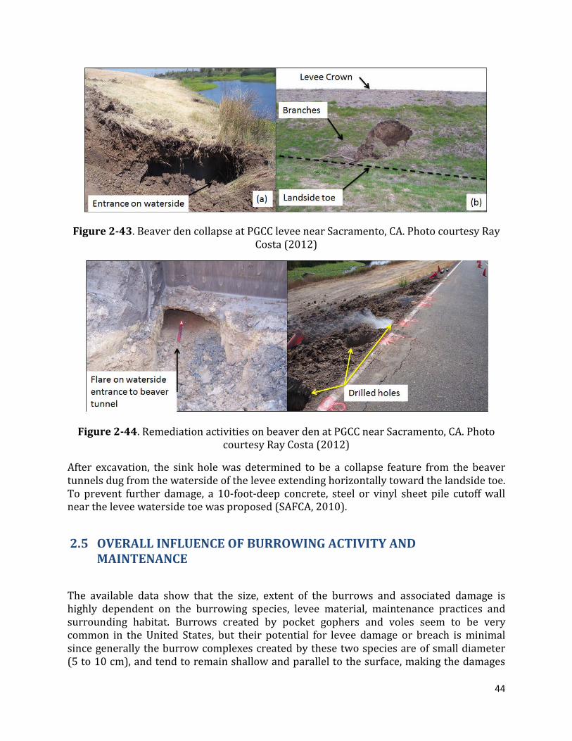
The final case history included in this document corresponds to a beaver den on the Pleasant Grove Creek Canal (PGCC) north of Sacramento, CA. The levee in this area is composed of compacted clays of medium to high plasticity, which may have allowed the beaver(s) to extend the den from one side of the levee to the other without collapsing (Figure 2-43). Emergency remediation consisted in excavating the sinkhole area, exposing tules, a small cavern and the tunnel extending to the waterside toe (Costa, 2012), and constructing temporary earthen plugs on both levee toes. Final remediation took place by drilling several holes along the top of the levee and filling them with concrete. Flares were placed at the entrance of the beaver den before the concrete was poured to verify that the drilled holes had in fact intersected the tunnel (Figure 2-44).
43
Figure 2-41. Beaver burrow below paved bike path along north levee of American River in 2006. Images courtesy of Richard Marck (ARFCD)
Figure 2-42. Waterside slope collapse from beaver burrow along NEMDC in 2006. Images courtesy of Richard Marck (ARFCD)
44
Figure 2-43. Beaver den collapse at PGCC levee near Sacramento, CA. Photo courtesy Ray Costa (2012)
Figure 2-44. Remediation activities on beaver den at PGCC near Sacramento, CA. Photo courtesy Ray Costa (2012)
After excavation, the sink hole was determined to be a collapse feature from the beaver tunnels dug from the waterside of the levee extending horizontally toward the landside toe. To prevent further damage, a 10-foot-deep concrete, steel or vinyl sheet pile cutoff wall near the levee waterside toe was proposed (SAFCA, 2010).
2.5 OVERALL INFLUENCE OF BURROWING ACTIVITY AND MAINTENANCE
The available data show that the size, extent of the burrows and associated damage is highly dependent on the burrowing species, levee material, maintenance practices and surrounding habitat. Burrows created by pocket gophers and voles seem to be very common in the United States, but their potential for levee damage or breach is minimal since generally the burrow complexes created by these two species are of small diameter (5 to 10 cm), and tend to remain shallow and parallel to the surface, making the damages
45
related to gophers more of a common surface maintenance issue than a structural issue. Holes from California ground squirrels are less frequent (but also very common). Van Vuren (2011) reports a six-fold difference on the occurrence of gopher burrows compared to squirrel burrows. However, the size, extents and potential damage from squirrel networks is much greater than smaller species. Most periodic burrow maintenance and animal eradication activities in California levees are aimed at controlling squirrels. Common squirrel burrows can be between 10 and 15 cm in diameter and the cumulative burrow network lengths have been reported to extend for several tens of meters inside a levee embankment. Muskrat burrows tend to be larger and deeper than squirrel, and have the potential to extend from the waterside toe to the landside toe, as evidenced by the failure on the Truckee Canal in 2008.
Finally, larger species such as beavers, skunks or some carnivores tend to generate the largest burrows and consequently the highest potential for levee damage. Dens of the size as reported at Medford Island (CA) generally result in collapse of the levee and immediate loss of flood protection, which during a flood, can result in widening of the collapsed area and breaching of a much longer levee segment. No reported incidents of breaches from beaver holes were encountered during the literature review, but several collapses under normal (summer) water were encountered. Van Vuren (2011) found no beaver intrusions in 2009 and 2010, most likely because beaver burrow entrances are dug under water and were difficult to find during the field portion of his study.
Personal communications with staff from the American River Flood Control District (ARFCD) allowed the authors to obtain several undocumented incidents of beaver intrusions, which were successfully found and repaired during normal (summer) canal water elevation. These intrusions were generally encountered near the water line, and where there is a waterside berm present the dens tend to remain within the berm and away from the levee. However, once beaver populations increase and there are periods of prolonged high water, some animals will move upslope and dig dens at or above the waterside toe, thus jeopardizing the safety of the levee or potentially causing it to fail.
Typically, the ARFCD and other levee maintenance districts find beaver damage during routine patrol and levee inspections. Mitigation of these incidents is achieved by excavating the dens and re-compacting the excavated portion of the levee. No population control is currently undertaken for beavers by ARFCD.
One of the authors joined personnel from ARFCD on a day-long inspection of several levees near Sacramento, CA, where infestations from different species were observed. During this inspection, several remediated beaver den sites were visited where active beaver dams were present, indicating recent activity from these animals. A new den ‘in progress’ was also encountered at a site with more than twenty years of reported beaver activity and constant den mitigation. The American River Flood Control District is considered to have a successful squirrel control program, which consists of regular baiting and yearly cement-bentonite grouting of the largest burrows. In some years more than 25,000 pounds of cement grout is used (ARFCD, 2012 – personal communication). Nevertheless, year after year new burrows will be opened necessitating ongoing, costly levee repair and maintenance.
46
3 SUMMARY
The available case histories and data indicate that both vegetation and animal activity can impact levee performance. The severity of this impact depends on tree and animal species, location of the tree, levee district maintenance practices, soil types and hydraulic loading the levee is subject to; thus it is not appropriate to consider all trees as imposing the same level of risk to all levees. As observed from USACE incident reports, majority of the reported vegetation related case histories point to vegetation as inhibiting maintenance and inspection, with none directly tied to an actual cause of levee failure. Conversely, several cases where vegetation was present along the waterside levee slope were reported to have limited erosion and fewer failures when compared to reaches without vegetation. In comparison, levee failures associated with animal burrowing appear to be well documented and apparently common, given the larger, more continuous openings within an embankment produced by the burrowing activity.
4 REFERENCES Allen, S., Dwyer, J., Wallace, D., Cook, E., 2003, Missouri River Flood of 1993: Role of Woody Corridor Width in Levee Protection, Journal of the American Water Resources Association (JAWRA) 39(4):923-933, Paper No. 02129, August. American River Flood Control District (ARFCD), 2012, Personal communications and field visits during January 2012. Bayoumi, A., Meguid, M., 2011, Wildlife and Safety of Earthen Structures: A Review, Journal of Failure Analysis and Prevention, 11:295-319, DOI 10.1007/s Benedict, R., 2008, Nevada Levee Failure, Newsletter Website, Institute for Crisis, Disaster and Risk Management, Volume 14 – Number 1, February. Clevenger, C., 1999, Mississippi Earthen Dams and the Beaver “Beavers and Earthen Dams Don’t Mix”, ASDSO/FEMA Specialty Workshop on Plant and Animal Penetrations of Earthfilled Dams. November 30-December 2, 1999. Costa, R., 2012, Personal Communication during January 2012 California Levee Vegetation Research Program meeting. D Van Troostwijk, W., 1978, Muskrat Control in the Netherlands. In: Proceedings of the 8th Vertebrate Pest Conference, University of Nebraska Lincoln. Daar, S., Klitz, W., Olkowski, W., 1984, The Role of Vegetation in an Integrated Pest Management Approach to Levee Management. California Riparian Systems: Ecology,
47
Conservation and Productive Management, University of California Press, Berkeley, California. Department of Water Resources (DWR), 2009, Internal Technical Memorandum, Assessment of Animal Burrow Hole Persistence on Project Levees, October. FEMA, 2005, Technical Manual for Dam Owners, Impacts of Animals on Earthen Dams, FEMA Report 473, September. Grey, D., Megahan, W., 1981, Forest Vegetation Removal and Slope Stability in the Idaho Batholith, USDA Research Paper INT-271, May. Harder, L. F., Vroman, N., Sills, G. L., Groves, C., and Kelley, J. R., 2009, Inspection of Levee Distress and Breaches During the Spring 2008 Midwest Flood, Association of Dam Safety Officials Conference. Kadlec, R., Priesb, J., Mustar, H., 2007, Muskrats (Ondatra zibethicus) in treatment wetlands. Ecol. Eng. 29, 143-153. MBK Engineers, 2009, Memorandum: Emergency Beaver Den Levee Repair, January 24-26, 2009. Report to Reclamation District 2041. Sacramento Area Flood Control Agency (SAFCA), 2010, 2009 Capital Outlay Funding Agreement, Quarter 10 Work Plan, July 1 2011 – September 30, 2011. Shields, F.D., and Gray, D., 1992, Effects of Woody Vegetation on Sandy Levee Integrity, Water Resources Bulletin, American Water Resources Association, Vol, 28, No. 5. October. Shriro, M., 2012, Study of the Influence of Tress on Levee Stability, Doctoral Dissertation in progress, University of California, Berkeley. U.S. Army Corps of Engineers, 2009, ETL 1110-2-571, Guidelines for Landscape Planting and Vegetation Management at Levees, Floodwalls, Embankments Dams, and Appurtenant Structures. U.S. Army Corps of Engineers, 2011, International Levee Manual, Chapter 4, accessed via personal communications with Sacramento District. U.S. Army Corps of Engineers, Incident Report: Vegetation Impact to FRM Infrastructure. Series of Reports provided in 2012 via personal communications. URS, 2008, Truckee Canal Failure on 5 January 2008, Investigative Evaluation Report, Prepared for US Bureau of Reclamation, March. URS, 2011, The Influence of Vegetation on Levee Past Performance – a Review of Historic Data Based on the Levee Evaluation Program Database, Report prepared for DWR.

48
van Baars, S., 2009, The Causes and Mechanisms of Historical Dike Failures in the Netherlands. Van Vuren, D., 2011, Habitat Associations of Burrowing Mammals along Levees in the Sacramento Valley, California, report to California Levee Vegetation Research Program, September. Ventura County Watershed Protection District, 2006, Approved Integrated Pest Management Program, Rodent Control for Flood Control Facility Protection, Water and Environmental Resources Division, December. Ziemer, R., 1991, Effect of Tree Roots on a Shear Zone: Modeling Reinforced Shear Stress, Canadian For. Res. 21:1012-1019, January.