Calderdale District Landscape Character Assessment and ...Calderdale District Landscape Character...
97
Calderdale District Landscape Character Assessment and Review of Special Landscape Area Designation Final Report Prepared by LUC for Calderdale District Council October 2016
Transcript of Calderdale District Landscape Character Assessment and ...Calderdale District Landscape Character...
Calderdale District Landscape Character
Assessment and Review of Special Landscape
Area Designation
Final Report
Prepared by LUC for Calderdale District Council
October 2016
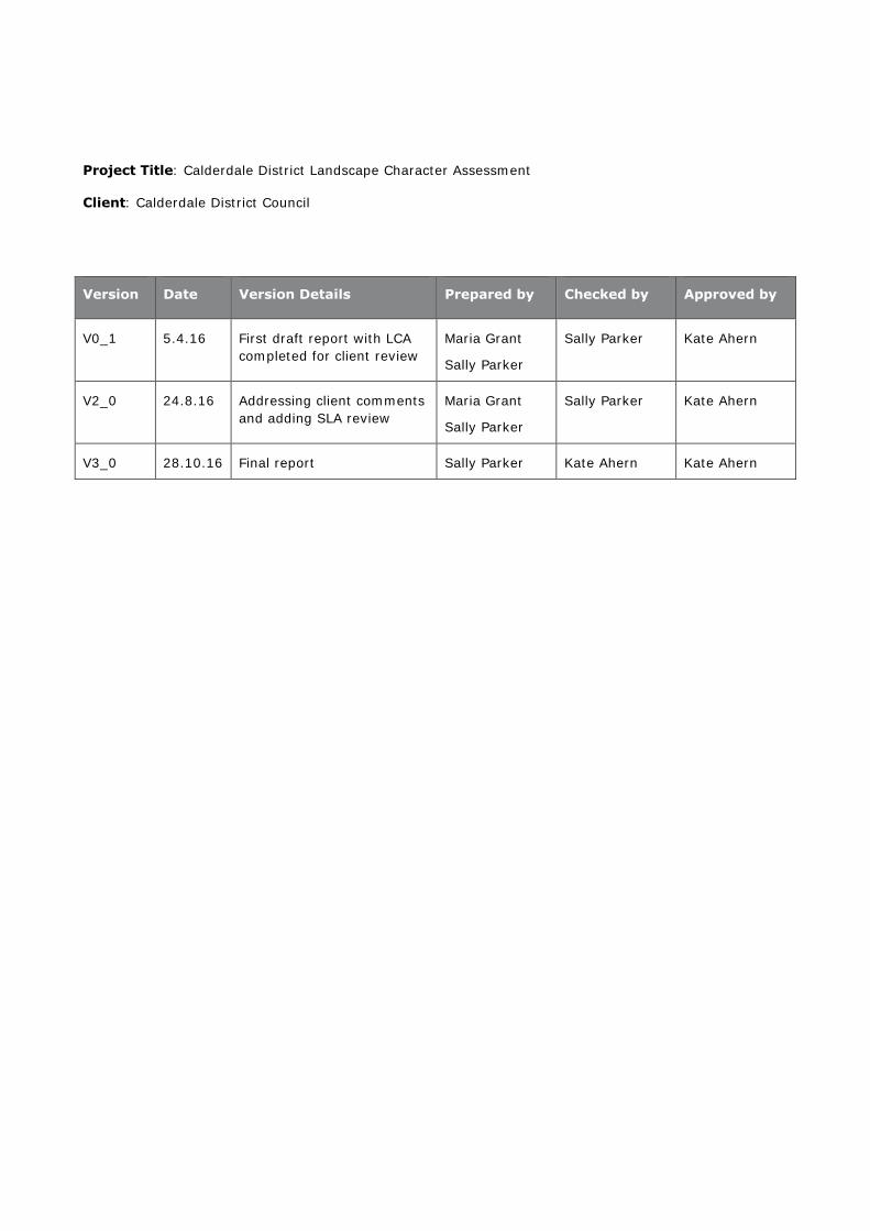
Project Title: Calderdale District Landscape Character Assessment
Client: Calderdale District Council
Version Date Version Details Prepared by Checked by Approved by
V0_1 5.4.16 First draft report with LCA
completed for client review
Maria Grant
Sally Parker
Sally Parker Kate Ahern
V2_0 24.8.16 Addressing client comments
and adding SLA review
Maria Grant
Sally Parker
Sally Parker Kate Ahern
V3_0 28.10.16 Final report Sally Parker Kate Ahern Kate Ahern

Calderdale District Landscape Character
Assessment and Review of Special Landscape
Area Designation
Final Report
Prepared by LUC for Calderdale District Council
October 2016
Planning & EIA Design Landscape Planning Landscape Management Ecology Mapping & Visualisation
LUC BRISTOL 12th Floor Colston Tower Colston Street Bristol BS1 4XE T +44 (0)117 929 1997 [email protected]
Offices also in: London Glasgow Edinburgh
FS 566056 EMS 566057
Land Use Consultants Ltd Registered in England Registered number: 2549296 Registered Office: 43 Chalton Street London NW1 1JD
LUC uses 100% recycled paper
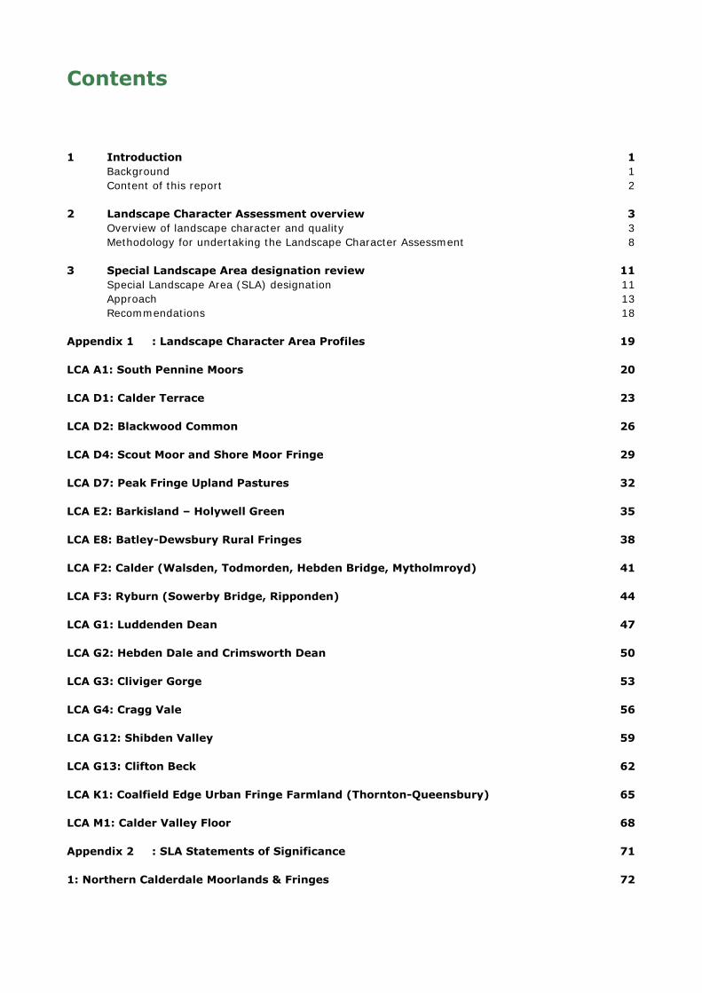
Contents
1 Introduction 1 Background 1 Content of this report 2
2 Landscape Character Assessment overview 3 Overview of landscape character and quality 3 Methodology for undertaking the Landscape Character Assessment 8
3 Special Landscape Area designation review 11 Special Landscape Area (SLA) designation 11 Approach 13 Recommendations 18
Appendix 1 : Landscape Character Area Profiles 19
LCA A1: South Pennine Moors 20
LCA D1: Calder Terrace 23
LCA D2: Blackwood Common 26
LCA D4: Scout Moor and Shore Moor Fringe 29
LCA D7: Peak Fringe Upland Pastures 32
LCA E2: Barkisland – Holywell Green 35
LCA E8: Batley-Dewsbury Rural Fringes 38
LCA F2: Calder (Walsden, Todmorden, Hebden Bridge, Mytholmroyd) 41
LCA F3: Ryburn (Sowerby Bridge, Ripponden) 44
LCA G1: Luddenden Dean 47
LCA G2: Hebden Dale and Crimsworth Dean 50
LCA G3: Cliviger Gorge 53
LCA G4: Cragg Vale 56
LCA G12: Shibden Valley 59
LCA G13: Clifton Beck 62
LCA K1: Coalfield Edge Urban Fringe Farmland (Thornton-Queensbury) 65
LCA M1: Calder Valley Floor 68
Appendix 2 : SLA Statements of Significance 71
1: Northern Calderdale Moorlands & Fringes 72

2: Hardcastle Crags, Hebden Water & Colden Water 75
3: Luddenden Dean 78
4: Shibden Valley 81
5: Ringstone Edge and Norland Moor Fringes 84
6: Southern Calderdale Moorlands & Fringes 87
7: Cragg Vale 90
Tables
Table 2.1: Landscape Character Assessment framework for Calderdale 6
Figures
Figure 2.1: Study area in context of nearby protected landscapes 4
Figure 2.2: National Character Area (NCA) framework 5
Figure 2.3: Calderdale Landscape Character Assessment framework (from the South Pennines Landscape
Character Assessment, 1999) 7
Figure 3.1: 2006 extent of Calderdale Special Landscape Area (SLA) designation 12
Figure 3.2: Proposed extent of SLA designation (2016) – showing relationship with 2006 SLA extent 14
Figure 3.3: Relationship between proposed SLA areas and existing Green Belt and Area around
Todmorden policies 17
Calderdale District Landscape Character Assessment and
Review of Special Landscape Area Designation
1 October 2016
1 Introduction
Background
Purpose of study
1.1 LUC was commissioned by Calderdale Council in order to provide an up-to-date evidence base on
landscape character within the district, which can be utilised by planners and developers alike.
Landscape Character Assessment (Chapter 2 and Appendix 1)
1.2 The first part of this study provides an updated Landscape Character Assessment for Calderdale
District, creating a sound evidence base for planners and developers to take account of the
character and valued features of the landscape when considering new development or land uses.
The primary aim of the assessment is to ensure the area’s distinctive and varied landscapes are
considered when siting new development or activities, with opportunities to enhance and
strengthen character pursued wherever possible. The need for this evidence base is all the more
apparent in the context of continual pressures to accommodate new development, against the
backdrop of a changing climate.
Special Landscape Area (SLA) designation review (Chapter 3 and Appendix 2)
1.3 The second part of this study comprises a review of the district’s Special Landscape Area (SLA)
designation, first defined in the West Yorkshire Structure Plan, 1980, and carried forward in the
Calderdale Unitary Development Plan in 1997 and extended in the Replacement Unitary
Development Plan, 2006. Using a thorough evidence-based assessment, this review recommends
seven separate landscape parcels within Calderdale for inclusion in an updated Special Landscape
Area policy in the forthcoming Local Plan.
National and local policy context
European Landscape Convention (ELC)
1.4 The European Landscape Convention (ELC) came into force in the UK in March 2007. It
establishes the need to recognise landscape in law; to develop landscape policies dedicated to the
protection, management and planning of landscapes; and to establish procedures for the
participation of the general public and other stakeholders in the creation and implementation of
landscape policies.
1.5 The ELC definition of ‘landscape’ recognises that all landscapes matter, be they ordinary,
degraded or outstanding:
“Landscape means an area, as perceived by people, whose character is the result of the
action and interaction of natural and/or human factors”.
1.6 The Convention puts emphasis on the whole landscape and all its values and is forward looking in
its approach, recognising the dynamic and changing character of landscape. Specific measures
promoted by the Convention, of direct relevance to this study include:
the identification and assessment of landscape; and
improved consideration of landscape in existing and future sectoral and spatial policy and
regulation.
National Planning Policy Framework
1.7 The National Planning Policy Framework (NPPF), published in 2012, states within its core planning
principles that planning should “take account of the different roles and character of different
areas, promoting the vitality of our main urban areas, protecting the Green Belts around them,
recognising the intrinsic character and beauty of the countryside and supporting thriving rural
communities within it” .
Calderdale District Landscape Character Assessment and
Review of Special Landscape Area Designation
2 October 2016
1.8 The NPPF calls for valued landscapes to be protected and enhanced (para 109), with the greatest
weight being given to conserving landscape and scenic beauty in National Parks and Areas of
Outstanding Natural Beauty (AONBs) (para 115). It also advocates a criteria-based approach to
developing local planning policies, against which proposals on or affecting protected landscape
areas will be judged. In the context of Calderdale, which does not include nationally designated
landscape areas, the Special Landscape Area designation provides a further tier of locally valued
landscapes. A criteria-based assessment of the district’s landscape underpins the areas
recommended for inclusion in a Special Landscape Area policy – as set out in Chapter 3.
1.9 An up-to-date Landscape Character Assessment is also recommended in the NPPF to support
planning decisions.
Local policy: Calderdale Local Plan
1.10 Calderdale Council are currently in the process of producing a new Local Plan, which is likely to be
adopted in 20171. This updated Landscape Character Assessment and the appraisal, justification
and description of areas recommended for Special Landscape Area designation provides evidence
for the preparation of the Calderdale Local Plan. Its findings and recommendations will be
considered as the Local Plan progresses, and changes to planning policy or the Policies Map will
be open to public comment later in the process, during consultation on a Draft Plan.
Content of this report
1.11 The remainder of this report is structured as follows:
Chapter 2 – provides an overview of Calderdale’s landscape character along with a summary
of the approach taken to produce a new Landscape Character Assessment for the district.
Chapter 3 – explains the process undertaken to review Calderdale’s Special Landscape Area
(SLA) designation, including recommendations for taking the designation forward.
Appendix 1 – contains the Landscape Character Area assessment profiles for all Landscape
Character Areas (LCAs) found within Calderdale.
Appendix 2 – contains the Statements of Value and Significance for the individual areas of
Calderdale proposed for SLA designation.
1 http://www.calderdale.gov.uk/environment/planning/planning-policy/local-plan/index.html
Calderdale District Landscape Character Assessment and
Review of Special Landscape Area Designation
3 October 2016
2 Landscape Character Assessment overview
Overview of landscape character and quality
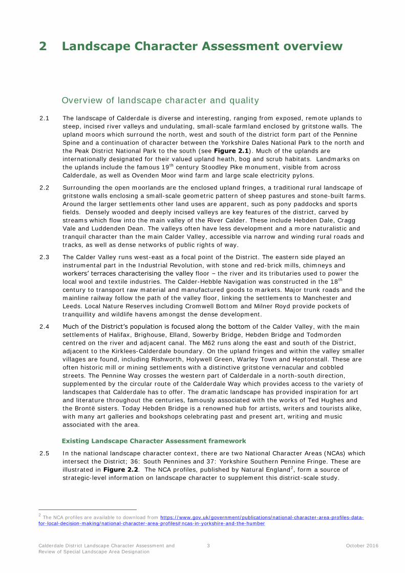
2.1 The landscape of Calderdale is diverse and interesting, ranging from exposed, remote uplands to
steep, incised river valleys and undulating, small-scale farmland enclosed by gritstone walls. The
upland moors which surround the north, west and south of the district form part of the Pennine
Spine and a continuation of character between the Yorkshire Dales National Park to the north and
the Peak District National Park to the south (see Figure 2.1). Much of the uplands are
internationally designated for their valued upland heath, bog and scrub habitats. Landmarks on
the uplands include the famous 19th century Stoodley Pike monument, visible from across
Calderdale, as well as Ovenden Moor wind farm and large scale electricity pylons.
2.2 Surrounding the open moorlands are the enclosed upland fringes, a traditional rural landscape of
gritstone walls enclosing a small-scale geometric pattern of sheep pastures and stone-built farms.
Around the larger settlements other land uses are apparent, such as pony paddocks and sports
fields. Densely wooded and deeply incised valleys are key features of the district, carved by
streams which flow into the main valley of the River Calder. These include Hebden Dale, Cragg
Vale and Luddenden Dean. The valleys often have less development and a more naturalistic and
tranquil character than the main Calder Valley, accessible via narrow and winding rural roads and
tracks, as well as dense networks of public rights of way.
2.3 The Calder Valley runs west-east as a focal point of the District. The eastern side played an
instrumental part in the Industrial Revolution, with stone and red-brick mills, chimneys and
workers’ terraces characterising the valley floor – the river and its tributaries used to power the
local wool and textile industries. The Calder-Hebble Navigation was constructed in the 18th
century to transport raw material and manufactured goods to markets. Major trunk roads and the
mainline railway follow the path of the valley floor, linking the settlements to Manchester and
Leeds. Local Nature Reserves including Cromwell Bottom and Milner Royd provide pockets of
tranquillity and wildlife havens amongst the dense development.
2.4 Much of the District’s population is focused along the bottom of the Calder Valley, with the main
settlements of Halifax, Brighouse, Elland, Sowerby Bridge, Hebden Bridge and Todmorden
centred on the river and adjacent canal. The M62 runs along the east and south of the District,
adjacent to the Kirklees-Calderdale boundary. On the upland fringes and within the valley smaller
villages are found, including Rishworth, Holywell Green, Warley Town and Heptonstall. These are
often historic mill or mining settlements with a distinctive gritstone vernacular and cobbled
streets. The Pennine Way crosses the western part of Calderdale in a north-south direction,
supplemented by the circular route of the Calderdale Way which provides access to the variety of
landscapes that Calderdale has to offer. The dramatic landscape has provided inspiration for art
and literature throughout the centuries, famously associated with the works of Ted Hughes and
the Brontë sisters. Today Hebden Bridge is a renowned hub for artists, writers and tourists alike,
with many art galleries and bookshops celebrating past and present art, writing and music
associated with the area.
Existing Landscape Character Assessment framework
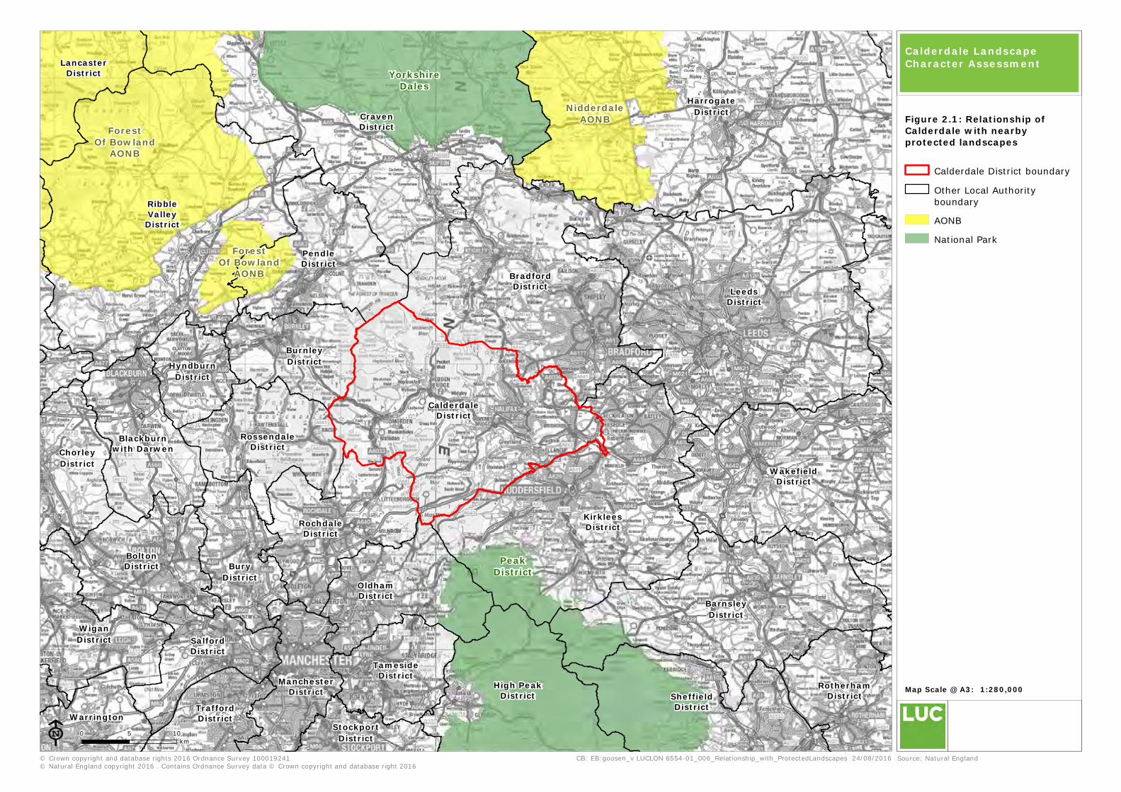
2.5 In the national landscape character context, there are two National Character Areas (NCAs) which
intersect the District; 36: South Pennines and 37: Yorkshire Southern Pennine Fringe. These are
illustrated in Figure 2.2. The NCA profiles, published by Natural England2, form a source of
strategic-level information on landscape character to supplement this district-scale study.
2 The NCA profiles are available to download from https://www.gov.uk/government/publications/national-character-area-profiles-data-
for-local-decision-making/national-character-area-profiles#ncas-in-yorkshire-and-the-humber
High PeakDistrict
LancasterDistrict
ChorleyDistrict
RossendaleDistrict
PendleDistrict
RibbleValleyDistrict
HyndburnDistrict
BurnleyDistrict
CravenDistrict
HarrogateDistrict
BarnsleyDistrict
BoltonDistrict
BradfordDistrict
BuryDistrict
CalderdaleDistrict
KirkleesDistrict
LeedsDistrict
ManchesterDistrict
OldhamDistrict
RochdaleDistrict
RotherhamDistrict
SalfordDistrict
SheffieldDistrict
StockportDistrict
TamesideDistrict
TraffordDistrict
WakefieldDistrict
WiganDistrict
Blackburnwith Darwen
Warrington
ForestOf Bowland
AONB
ForestOf Bowland
AONB
NidderdaleAONB
PeakDistrict
YorkshireDales
© Crown copyright and database rights 2016 Ordnance Survey 100019241© Natural England copyright 2016 . Contains Ordnance Survey data © Crown copyright and database right 2016
0 5 10km
CB: EB:goosen_v LUCLON 6554-01_006_Relationship_with_ProtectedLandscapes 24/08/2016
Map Scale @ A3: 1:280,000
ESource: Natural England
Calderdale District boundary
Other Local Authority
boundary
AONB
National Park
Calderdale Landscape Character Assessment
Figure 2.1: Relationship ofCalderdale with nearbyprotected landscapes
21 21
22
30
33
34
35
36
37
38
51
54
5556High Peak
District
RossendaleDistrict
PendleDistrict
RibbleValleyDistrict
HyndburnDistrict
BurnleyDistrict
CravenDistrict
HarrogateDistrict
BarnsleyDistrict
BoltonDistrict
BradfordDistrict
BuryDistrict
CalderdaleDistrict
KirkleesDistrict
LeedsDistrict
ManchesterDistrict
OldhamDistrict
RochdaleDistrict
SalfordDistrict
SheffieldDistrict
TamesideDistrict
WakefieldDistrict
Blackburnwith
Darwen
© Crown copyright and database rights 2016 Ordnance Survey 100019241© Natural England copyright 2016 . Contains Ordnance Survey data © Crown copyright and database right 2016
0 5 10km
CB: EB:goosen_v LUCLON 6554-01_007_NCAs_Option2 24/08/2016
Map Scale @ A3: 1:200,000
ESource: Natural England
Calderdale District boundary
Other Local Authority
boundary
Calderdale Landscape Character Assessment
Figure 2.2: National CharacterAreas
National Character Areas21: Yorkshire Dales
22: Pennine Dales Fringe
30: Southern Magnesian
Limestone
33: Bowland Fringe And
Pendle Hill
34: Bowland Fells
35: Lancashire Valleys
36: Southern Pennines
37: Yorkshire Southern
Pennine Fringe
38: Nottinghamshire
Derbyshire And Yorkshire
Coalfield
51: Dark Peak
54: Manchester Pennine
Fringe
55: Manchester Conurbation
56: Lancashire Coal Measures
60: Mersey Valley

Calderdale District Landscape Character Assessment and
Review of Special Landscape Area Designation
6 October 2016
2.6 At a district level, an existing Landscape Character Framework is in place derived from several
previous studies, namely the South Pennines Landscape Character Assessment commissioned by
SCOSPA3, the Landscape Capacity Study for Wind Energy Developments in the South Pennines4
and, most recently, the 2014 South Pennines Wind Energy Landscape Study5. Since the main
source for all of these studies is the 1999 South Pennines Landscape Character Assessment,
information on landscape character is now significantly out of date.
2.7 This study therefore aims to provide more detailed district-specific assessment, with up to date
information and data on each of the Landscape Character Areas found in Calderdale. As shown in
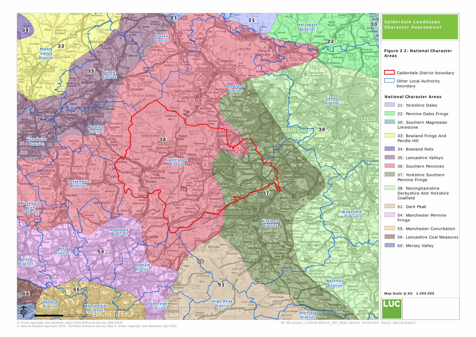
Figure 2.3, there are a total of seven Landscape Character Types (LCTs) fully within the district
comprising 17 component Landscape Character Areas (LCAs) wholly or partially within Calderdale.
Please note that Landscape Character Types O (Industrial/Business Parks) and U (Urban) are
excluded from this study. No alterations have been made to the spatial framework to ensure
compatibility with the previous studies mentioned above. The relationship between the LCTs and
LCAs is also shown in Table 2.1 below.
Table 2.1: Landscape Character Assessment framework for Calderdale
Landscape Character Types Landscape Character Areas
A – High Moorland Plateaux A1: South Pennine Moors
D – Moorland Fringes/Upland Pastures D1: Calder Terrace
D2: Blackwood Common
D4: Scout Moor and Shore Moor Fringe
D7: Peak Fringe Upland Pastures
E – Rural Fringes E2: Barkisland – Holywell Green
E8: Batley – Dewsbury Rural Fringes
F – Settled Valleys F2: Calder (Todmorden, Hebden Bridge, Mytholmroyd)
F3: Ryburn (Sowerby Bridge, Ripponden)
G – Wooded Rural Valleys G1: Luddenden Dean
G2: Hebden Dale and Crimsworth Dean
G3: Cliviger Gorge
G4: Cragg Vale
G12: Shibden Valley
G13: Clifton Beck
K – Coalfield Edge Urban Edge Farmland K1: Thornton - Queensbury
M – Industrial Lowland Valleys M1: Calder Valley Floor
3 LUC (1999) South Pennines Landscape Character Assessment, report to Standing Conference of South Pennine Authorities (SCOSPA).
4 Julie Martin Associates (2010) Landscape Capacity Study for Wind Energy Developments in the South Pennines
5 Julie Martin Associates and LUC (2014) South Pennines Wind Energy Landscape Study, available at
http://www.rossendale.gov.uk/info/856/local_development_framework/302/planning_policy_evidence_base/9
RossendaleDistrict
PendleDistrict
BurnleyDistrict
BradfordDistrict
CalderdaleDistrict
KirkleesDistrict
OldhamDistrict
RochdaleDistrict
E1
E1
E1
A1
A1
A1
A1
D7
D7
D2
D2D2
D4
D4 D1
D1
D1D1
G4
G3
G1
G2
D3
M1
M1
F5 G8
F4
K1
K1
K1
K1
K1
E8
E8
E7
G9E6
E2
G12F2
F1
G13
E4
A2
F3
U
U
U
UU
U
U
U
U
U
U
O
© Crown copyright and database rights 2016 Ordnance Survey 100019241
0 5 10
km
CB: EB:goosen_v LUCLON 6554-01_005_LCT_LCA 24/08/2016
Map Scale @ A3: 1:100,000
ESource:
Calderdale Landscape Character Assessment
Figure 2.3: Landscape CharacterTypes and Areas
Calderdale District Boundary
Other Local Authority
boundary
A1: South Pennine Moors
D1: Calder Terrace
D2: Blackwood Common
D4: Scout Moor and Shore Moor
Fringe
D7: Peak Fringe Upland Pastures
E2: Barkisland - Holywell Green
E8: Batley - Dewsbury Rural
Fringes
F2: Calder (Todmorden Hebden
Bridge Mytholmroyd)
F3: Ryburn (Sowerby Bridge
Ripponden)
G12: Shibden Valley
G13: Clifton Beck
G1: Luddenden Dean
G2: Hebden Dale & Crimsworth
Dean
G3: Cliviger Gorge
G4: Cragg Vale
K1: Thornton - Queensbury
M1: Calder Valley Floor
A: High Moorland Plateaux
D: Moorland Fringes / Upland
Pastures
E: Rural Fringes
F: Settled Valleys
G: Wooded Rural Valleys
K: Coalfield Edge Urban
Fringe Farmland
M: Industrial Lowland Valleys
U: Urban
Calderdale District Landscape Character Assessment and
Review of Special Landscape Area Designation
8 October 2016
Methodology for undertaking the Landscape Character Assessment
2.8 The methodology for updating the Landscape Character Assessment consisted of three main
stages; a desk-based review of available mapped and descriptive information relevant to
landscape character; field survey visits to all Landscape Character Areas (LCAs) found within the
district; and consultation and reporting. These are described in further detail below.
2.9 Appendix 1 comprises the full set of Landscape Character Area assessment profiles for
Calderdale.
Stage 1: Desk Study
Compiling key characteristics
2.10 Available data and information was interrogated in order to compile an updated draft set of key
characteristics for each Landscape Character Area found in Calderdale. For ease of reference,
these are structured under the following headings:
Topography, geology and drainage
Woodland cover
Land use and field patterns
Semi-natural habitats
Archaeology and cultural heritage
Settlement and road pattern
Views and perceptual qualities
Landscape evaluation
2.11 In addition to the compilation of key characteristics, a landscape evaluation was undertaken for
each LCA, detailing valued landscape features and attributes that would need to be taken account
of in particular when considering future development or land use changes within the landscape.
The current Natural England recommended ’Approach to Landscape Character Assessment’
(2014)6 includes a definition of ‘Landscape Value’ in Annex 1, stated as:
“The relative value or importance attached to a landscape… which expresses national or local
consensus, because of its quality, special qualities including perceptual aspects such as scenic
beauty, tranquillity or wildness, cultural associations or other conservation issues”.
2.12 The current Landscape Institute/ IEMA Guidelines for Landscape and Visual Assessment (third
edition, 2013) also includes a helpful summary of the range of factors that can help in the
identification of valued landscapes. This is included below.
2.13 Calderdale’s landscape evaluation was undertaken using the criteria on the following page, with
reference to any local, regional or national designations of relevance.
6 Available at: https://www.gov.uk/government/uploads/system/uploads/attachment_data/file/396192/landscape-character-
assessment.pdf
Calderdale District Landscape Character Assessment and
Review of Special Landscape Area Designation
9 October 2016
Range of factors that can help in the identification of valued landscapes (from GLVIA 3,
2013)
Geodiversity and biodiversity
2.14 This criterion provides an explanation of coverage of local, national and/or international
conservation designations, including Special Areas of Conservation, Special Protected Areas, Sites
of Special Scientific Interest, Local Geological Sites, Local Nature Reserves and Local Wildlife
Sites.
Cultural and historical
2.15 This section identifies local, national and/or international heritage designations including
Scheduled Monuments, Registered Parks and Gardens, Listed Buildings, Conservation Areas and
Registered Battlefields. It also examines whether any of these assets are include on the Heritage
at Risk Register.
Perceptual qualities (including levels of tranquillity) and views
2.16 This section is used to identify areas of relative tranquillity in the District using CPRE mapping and
information gathered by LUC’s landscape professionals during the field verification stage.
Role as a setting to development and visual connections with other landscapes
2.17 This section identifies where an LCA plays an important role as a ‘rural’ backdrop/setting to a
settlement or urban area. It also considers the important visual connections between the LCA and
adjacent landscapes – information gained from the field survey stage.
Access and enjoyment of the landscape
2.18 Identifies where there are recreational facilities and opportunities for the experiencing the
landscape by the public. This considers the presence of the following assets; Country Parks,
Public Rights of Way network, National Trails, Long distance walking routes, Common Land and
Open Access Land.
Calderdale District Landscape Character Assessment and
Review of Special Landscape Area Designation
10 October 2016
Stage 2: Field survey verification
2.19 The field verification task took place during March 2016, collecting information ‘on the ground’ to
verify, refine and add information to the key characteristics and landscape evaluations drafted
during the desk based stage. The field survey was also used to record information on views,
visual connections between landscapes, and perceptual qualities. Representative photographs of
each of the Landscape Character Areas were also taken during the field visits.
Stage 3: Reporting
2.20 Draft Landscape Character Area assessment profiles were prepared following fieldwork, with
further information incorporated following comments from the Council. The final LCA profiles,
which form the basis for the Calderdale Landscape Character Assessment, are included in
Appendix 1 of this report.
2.21 These are structured as follows:
A location map, representative photographs and summary of the location of the LCA within
Calderdale (including, if relevant, where the LCA continues into surrounding authorities);
Key characteristics, structured under the following headings:
o Topography, geology and drainage
o Woodland cover
o Land use and field patterns
o Semi-natural habitats
o Archaeology and cultural heritage
o Settlement, road pattern and rights of way
o Views and perceptual qualities
Landscape evaluation, with data and information of relevance to the LCA presented under the
following headings:
o Geodiversity and biodiversity
o Cultural and historical
o Perceptual qualities (including levels of tranquillity)
o Role as a setting to development and visual connections with other landscapes
o Access and enjoyment of the landscape
2.22 The profiles are organised in alphabetical/numeric order, starting with LCA A1: South Pennine
Moors.
Calderdale District Landscape Character Assessment and
Review of Special Landscape Area Designation
11 October 2016
3 Special Landscape Area designation review
Special Landscape Area (SLA) designation
3.1 The SLA designation was first defined in the West Yorkshire Structure Plan, 1980 and carried
forward within the Calderdale Unitary Development Plan in 1997 (Policy NE116). It was
reaffirmed and extended under Policy NE12 of the Replacement Unitary Development Plan, 2006
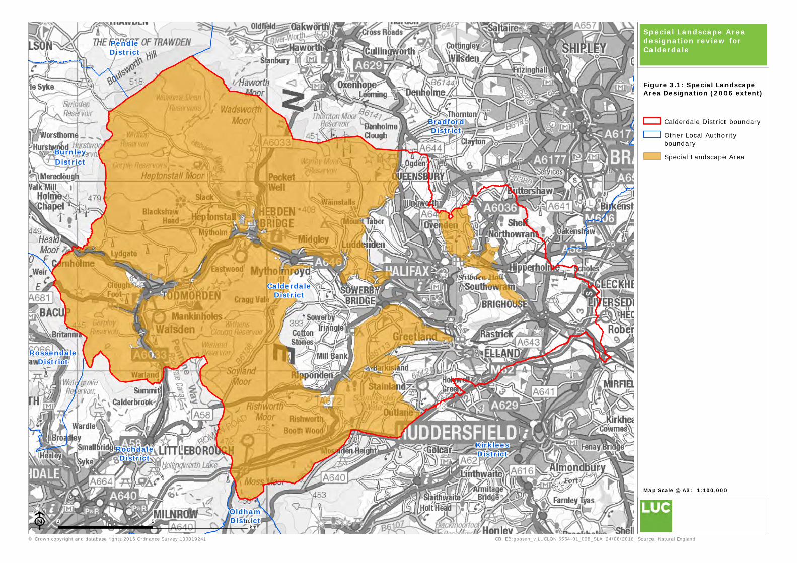
(amended August 2009). The 2006 extent of the SLA for Calderdale is included in Figure 3.1,
showing that the designation covers over half of the district; the main exclusions limited to the
east – associated with the combined urban areas and fringes of Halifax, Sowerby Bridge,
Brighouse, Northowram, Shelf, Elland and Holywell Green. A relatively significant pocket of the
district is also excluded to the west and south-west of Sowerby Bridge; and to the north and
north-west of Ripponden – including the villages of Cotton Stones, Mill Bank and Sowerby and
their surrounding countryside.
Unitary Development Plan policy
3.2 The explanation and policy wording for the Special Landscape Area designation, taken from the
Unitary Development Plan (UDP), is included below and in Box 3.1:
“…In much of Calderdale the countryside is of a very high visual quality; a combination of
impressive landscape, buildings of architectural and historical significance and areas of ecological
importance. Furthermore, in many places, this landscape is visible and accessible from urban
areas. Both culturally and environmentally the landscape to the west of the District also forms an
important part of the Southern Pennines, linking the Peak District and Yorkshire Dales National
Parks. The most important landscapes of the District need to be safeguarded and have therefore
been designated as a Special Landscape Area (SLA)”.
Box 3.1: Policy NE12 wording from UDP (2006, as amended August 2009)
Policy NE12: Development within the Special Landscape Area
Within the Special Landscape Area, development which would adversely affect landscape quality
will not be permitted. Special attention should be paid to conserving and enhancing the visual
quality and minimising the environmental impact of development in the area through detailed
consideration of the siting, materials and design of the new development.
Need for designation review
3.3 There is currently no supporting evidence to underpin the UDP’s SLA designation, making it
increasingly difficult to defend or apply in support of development management decisions. This
includes a lack of information as to exactly why the landscapes within the SLA are classified as
the most important in the District, how the boundary was drawn, or what particular landscape
characteristics or qualities need to be considered in the siting and design of new development.
3.4 Along with the information contained in the updated Landscape Character Assessment, this part
of the study has taken a careful criteria-based approach to review the current designation and
make recommendations for its amendment and potential inclusion in the forthcoming Local Plan.
3.5 As the SLA designation is concerned with landscape value, the approach also aligns with available
national guidance as summarised in previous paragraphs 2.11 to 2.13. In addition, the choice of
assessment criteria builds on the experience of other local landscape designation studies
undertaken in England, Wales and Scotland7 over the previous decade.
7 This includes recommendations from Scottish Natural Heritage guidance (March 2004: Guidance on Local Landscape Designations)
RossendaleDistrict
PendleDistrict
BurnleyDistrict
BradfordDistrict
CalderdaleDistrict
KirkleesDistrict
OldhamDistrict
RochdaleDistrict
© Crown copyright and database rights 2016 Ordnance Survey 100019241
0 5 10
km
CB: EB:goosen_v LUCLON 6554-01_008_SLA 24/08/2016
Map Scale @ A3: 1:100,000
ESource: Natural England
Calderdale District boundary
Other Local Authority
boundary
Special Landscape Area
Special Landscape Area designation review for Calderdale
Figure 3.1: Special LandscapeArea Designation (2006 extent)
Calderdale District Landscape Character Assessment and
Review of Special Landscape Area Designation
13 October 2016
Approach
Key steps and criteria used to review Calderdale’s SLA designation
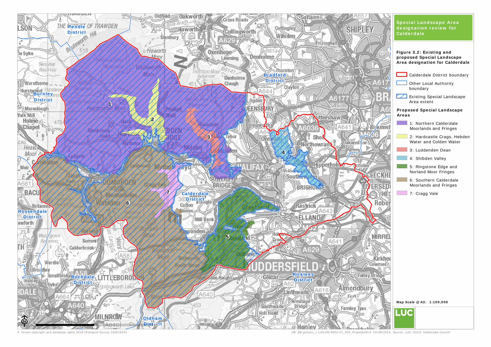
3.6 A four-step approach was followed:
Step 1: Defining Strategic Criteria – establishing whether there is a valid, defensible and
clearly justified need for SLA designation in Calderdale. This study defined a set of six criteria
(two ‘practical’ criteria; two four ‘landscape and visual’ criteria) against which the district’s
landscape was judged, ensuring that a consistent process was followed in considering the
need for local designation. These are defined at Table 3.1.
Step 2: Establishing Broad Search Areas – which in the case of Calderdale, comprised the
UDP’s 2006 SLA extent with reference to the spatial framework provided by the District’s
Landscape Character Areas (as described in Chapter 2 and Figure 2.3 of this report).
Step 3: Refining areas covered by Special Landscape Area designation – spatially
distinct areas of SLA designation were identified and refined by more detailed desk-based
work and field survey. For each SLA parcel identified, a clear statement of need was drafted
and any links/amendments to the current designation documented where appropriate. At this
point, the Council was consulted with to approve the recommendations for future SLA
designation.
Step 4: Preparing Statements of Significance– once the proposed extent of SLA
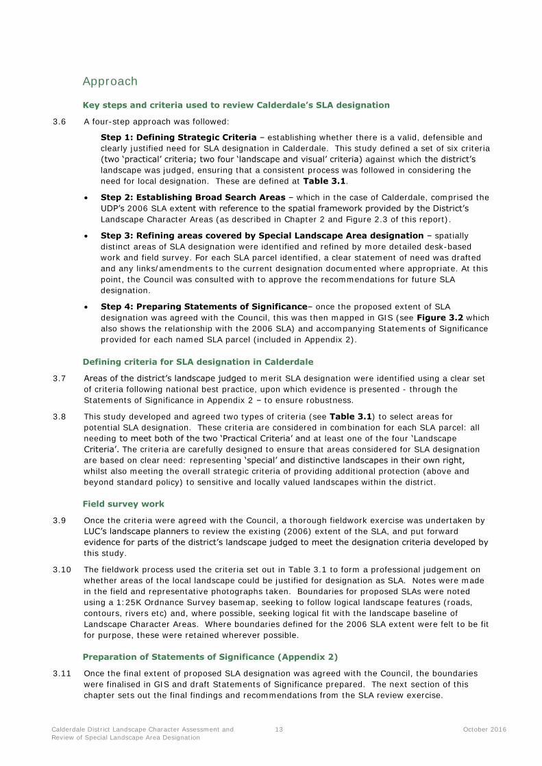
designation was agreed with the Council, this was then mapped in GIS (see Figure 3.2 which
also shows the relationship with the 2006 SLA) and accompanying Statements of Significance
provided for each named SLA parcel (included in Appendix 2).
Defining criteria for SLA designation in Calderdale
3.7 Areas of the district’s landscape judged to merit SLA designation were identified using a clear set
of criteria following national best practice, upon which evidence is presented - through the
Statements of Significance in Appendix 2 – to ensure robustness.
3.8 This study developed and agreed two types of criteria (see Table 3.1) to select areas for
potential SLA designation. These criteria are considered in combination for each SLA parcel: all
needing to meet both of the two ‘Practical Criteria’ and at least one of the four ‘Landscape
Criteria’. The criteria are carefully designed to ensure that areas considered for SLA designation
are based on clear need: representing ‘special’ and distinctive landscapes in their own right,
whilst also meeting the overall strategic criteria of providing additional protection (above and
beyond standard policy) to sensitive and locally valued landscapes within the district.
Field survey work
3.9 Once the criteria were agreed with the Council, a thorough fieldwork exercise was undertaken by
LUC’s landscape planners to review the existing (2006) extent of the SLA, and put forward
evidence for parts of the district’s landscape judged to meet the designation criteria developed by
this study.
3.10 The fieldwork process used the criteria set out in Table 3.1 to form a professional judgement on
whether areas of the local landscape could be justified for designation as SLA. Notes were made
in the field and representative photographs taken. Boundaries for proposed SLAs were noted
using a 1:25K Ordnance Survey basemap, seeking to follow logical landscape features (roads,
contours, rivers etc) and, where possible, seeking logical fit with the landscape baseline of
Landscape Character Areas. Where boundaries defined for the 2006 SLA extent were felt to be fit
for purpose, these were retained wherever possible.
Preparation of Statements of Significance (Appendix 2)
3.11 Once the final extent of proposed SLA designation was agreed with the Council, the boundaries
were finalised in GIS and draft Statements of Significance prepared. The next section of this
chapter sets out the final findings and recommendations from the SLA review exercise.
RossendaleDistrict
PendleDistrict
BurnleyDistrict
BradfordDistrict
CalderdaleDistrict
KirkleesDistrict
OldhamDistrict
RochdaleDistrict
1
4
6
5
7
3
2
© Crown copyright and database rights 2016 Ordnance Survey 100019241
0 5 10
km
CB: EB:goosen_v LUCLON 6554-01_009_ProposedSLA 24/08/2016
Map Scale @ A3: 1:100,000
ESource: LUC, DCLG, Calderdale Council
Calderdale District boundary
Other Local Authority
boundary
Existing Special Landscape
Area extent
Proposed Special LandscapeAreas
1: Northern Calderdale
Moorlands and Fringes
2: Hardcastle Crags, Hebden
Water and Colden Water
3: Luddenden Dean
4: Shibden Valley
5: Ringstone Edge and
Norland Moor Fringes
6: Southern Calderdale
Moorlands and Fringes
7: Cragg Vale
Special Landscape Area designation review forCalderdale
Figure 3.2: Existing andproposed Special LandscapeArea designation for Calderdale

Calderdale District Landscape Character Assessment and
Review of Special Landscape Area Designation
15 October 2016
Table 3.1: Criteria for Special Landscape Area designation
Criteria and rationale Factors to consider Source of evidence
Practical criteria (all potential SLA parcels need to meet both)
Need
To what extent will designation provide for
the more effective management and
planning of the special attributes of the
area being considered for designation?
Presence/absence of other local or national landscape
designations
Strong recommendation from local planning authority
on need for additional level of designation/protection
for particular areas
Areas where the local planning authority has identified
particular pressures and need for positive planning
and management to conserve special character.
None of the district is covered by any other
protective landscape designations. The Green
Belt covers much of the eastern half of the
district, and the ‘Area around Todmorden’
(UDP Policy NE 8) covers the western part.
This latter policy was defined in response to a
lack of Greenbelt designation for western
Calderdale due to lower levels of development
pressure related to nearby conurbations.
However, neither of these policies reflects or
responds to landscape quality specifically. It is
recognised (including through this study) that
many parts of Calderdale are landscapes
worthy of additional recognition and protection
through specific local landscape designation.
Figure 3.3 shows the relationship between the
proposed SLA areas and the existing Greenbelt
and ‘Area around Todmorden’ designations.
Integrity / cohesiveness of landscape
character
Is the area to be designated both
coherent enough (in terms of character)
and of sufficient size to make it practical
to develop policies for its protection,
management and planning?
Size – an SLA parcel must be more than an individual
landscape feature or site.
Recognisable as a cohesive area– may have distinct
boundaries (e.g. formed by one or more Landscape
Character Areas)
Landscape Character Assessment (2016)
information
Field survey
Calderdale District Landscape Character Assessment and
Review of Special Landscape Area Designation
16 October 2016
Criteria and rationale Factors to consider Source of evidence
Landscape and visual criteria (all potential SLA parcels need to meet at least one)
Local distinctiveness and sense of
place
Is the landscape particularly rare/unique
or special in the local context?
Does the landscape provide an important
contribution to local distinctiveness/sense
of place?
Coherent landscape character conferring a
recognisable sense of place
Distinct landform or topography forming a discrete
and recognisable area
Strong character linked to cultural or natural
factors – which contribute to understanding of its
historic character and wider cultural record or a create
a strong degree of naturalness
Forms a valued setting to built-up or urban areas
including those recognised for their built heritage (e.g.
Conservation Areas)
Landscape Character Assessment (2016)
information
Historic and cultural landscape designations
Nature/wildlife designations
Field survey
Landscape quality
Does the proposed SLA contribute to
important landscape and visual qualities
associated with the local landscape?
An intact landscape with characteristic landscape
elements well represented throughout
A landscape with characteristic elements in good
condition
Incongruous elements or features either not present
or not having an overwhelming influence on
landscape character and quality
Landscape Character Assessment (2016)
information
Field survey
Scenic quality
Does the landscape have particular scenic
and aesthetic qualities and appeal to the
senses?
Strong visual character with memorable, important
or distinctive views.
Special perceptual qualities such as strong sense of
relative tranquillity or remoteness
Landscape Character Assessment (2016)
information
Field survey
Access and enjoyment
To what extent is the landscape valued by
local people and/or visitors for access and
enjoyment?
Opportunities provided for access and recreation
e.g. access land, rights of way, visitor
attractions/facilities
Close proximity and access/rights of way linking to
centres of population
Landscape Character Assessment (2016)
information
Ordnance Survey basemapping
Field survey

RossendaleDistrict
PendleDistrict
BurnleyDistrict
BradfordDistrict
CalderdaleDistrict
KirkleesDistrict
OldhamDistrict
RochdaleDistrict
1
4
6
5
7
3
2
© Crown copyright and database rights 2016 Ordnance Survey 100019241
0 5 10
km
CB: EB:goosen_v LUCLON 6554-01_010_ProposedSLA_GreenBelt 24/08/2016
Map Scale @ A3: 1:100,000
ESource: LUC, DCLG, Calderdale Council
Calderdale District boundary
Other Local Authority
boundary
Green belt
Area around Todmorden
Proposed Special LandscapeAreas
1: Northern Calderdale
Moorlands and Fringes
2: Hardcastle Crags, Hebden
Water and Colden Water
3: Luddenden Dean
4: Shibden Valley
5: Ringstone Edge and
Norland Moor Fringes
6: Southern Calderdale
Moorlands and Fringes
7: Cragg Vale
Special Landscape Area designation review forCalderdale
Figure 3.3: Proposed SLAdesignation and relationshipwith other policies
Calderdale District Landscape Character Assessment and
Review of Special Landscape Area Designation
18 October 2016
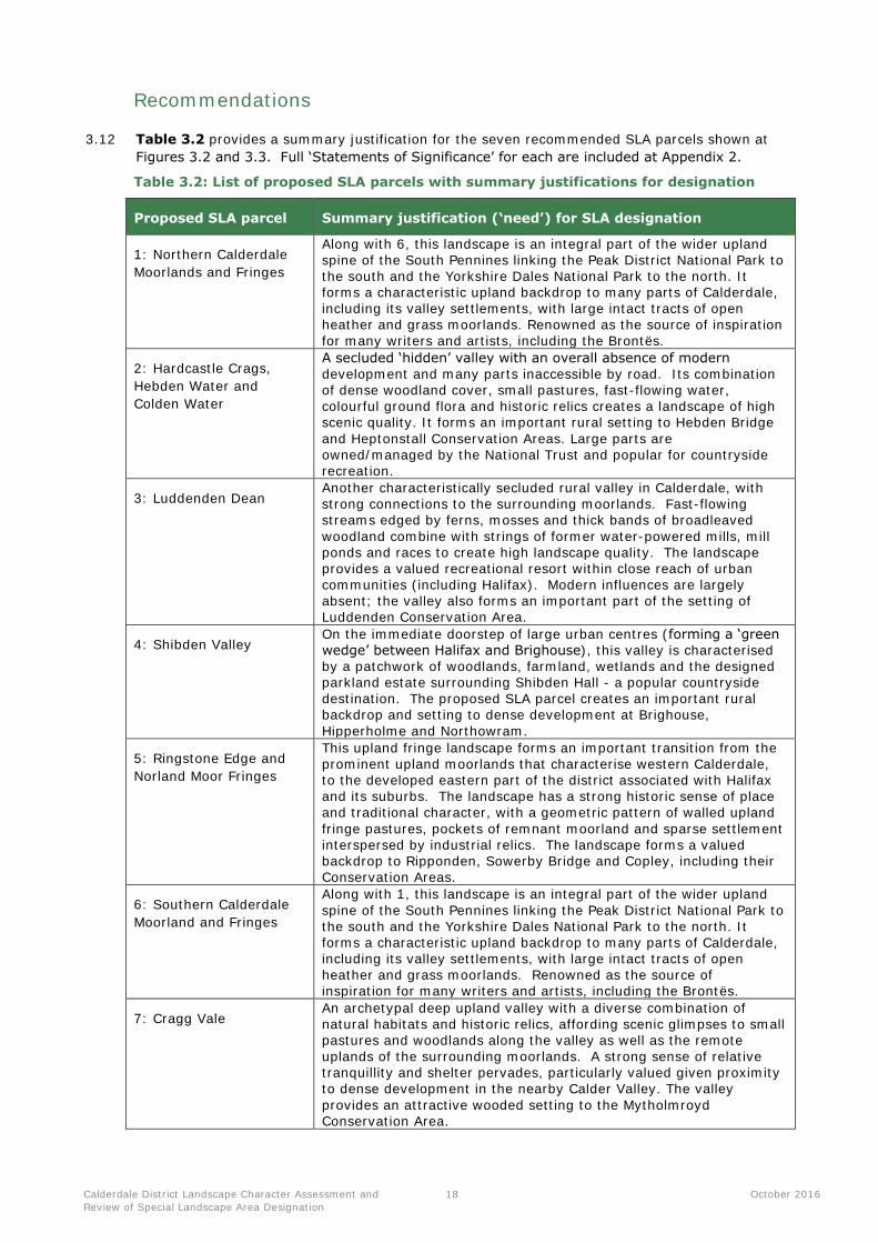
Recommendations
3.12 Table 3.2 provides a summary justification for the seven recommended SLA parcels shown at
Figures 3.2 and 3.3. Full ‘Statements of Significance’ for each are included at Appendix 2.
Table 3.2: List of proposed SLA parcels with summary justifications for designation
Proposed SLA parcel Summary justification (‘need’) for SLA designation
1: Northern Calderdale
Moorlands and Fringes
Along with 6, this landscape is an integral part of the wider upland spine of the South Pennines linking the Peak District National Park to the south and the Yorkshire Dales National Park to the north. It forms a characteristic upland backdrop to many parts of Calderdale, including its valley settlements, with large intact tracts of open heather and grass moorlands. Renowned as the source of inspiration
for many writers and artists, including the Brontës.
2: Hardcastle Crags,
Hebden Water and
Colden Water
A secluded ‘hidden’ valley with an overall absence of modern development and many parts inaccessible by road. Its combination of dense woodland cover, small pastures, fast-flowing water, colourful ground flora and historic relics creates a landscape of high scenic quality. It forms an important rural setting to Hebden Bridge
and Heptonstall Conservation Areas. Large parts are owned/managed by the National Trust and popular for countryside recreation.
3: Luddenden Dean Another characteristically secluded rural valley in Calderdale, with strong connections to the surrounding moorlands. Fast-flowing streams edged by ferns, mosses and thick bands of broadleaved
woodland combine with strings of former water-powered mills, mill ponds and races to create high landscape quality. The landscape provides a valued recreational resort within close reach of urban
communities (including Halifax). Modern influences are largely absent; the valley also forms an important part of the setting of Luddenden Conservation Area.
4: Shibden Valley On the immediate doorstep of large urban centres (forming a ‘green wedge’ between Halifax and Brighouse), this valley is characterised by a patchwork of woodlands, farmland, wetlands and the designed parkland estate surrounding Shibden Hall - a popular countryside destination. The proposed SLA parcel creates an important rural backdrop and setting to dense development at Brighouse,
Hipperholme and Northowram.
5: Ringstone Edge and
Norland Moor Fringes
This upland fringe landscape forms an important transition from the prominent upland moorlands that characterise western Calderdale, to the developed eastern part of the district associated with Halifax and its suburbs. The landscape has a strong historic sense of place
and traditional character, with a geometric pattern of walled upland
fringe pastures, pockets of remnant moorland and sparse settlement interspersed by industrial relics. The landscape forms a valued backdrop to Ripponden, Sowerby Bridge and Copley, including their Conservation Areas.
6: Southern Calderdale
Moorland and Fringes
Along with 1, this landscape is an integral part of the wider upland
spine of the South Pennines linking the Peak District National Park to the south and the Yorkshire Dales National Park to the north. It forms a characteristic upland backdrop to many parts of Calderdale, including its valley settlements, with large intact tracts of open heather and grass moorlands. Renowned as the source of inspiration for many writers and artists, including the Brontës.
7: Cragg Vale An archetypal deep upland valley with a diverse combination of natural habitats and historic relics, affording scenic glimpses to small pastures and woodlands along the valley as well as the remote
uplands of the surrounding moorlands. A strong sense of relative tranquillity and shelter pervades, particularly valued given proximity to dense development in the nearby Calder Valley. The valley
provides an attractive wooded setting to the Mytholmroyd Conservation Area.
Calderdale District Landscape Character Assessment and
Review of Special Landscape Area Designation
19 October 2016
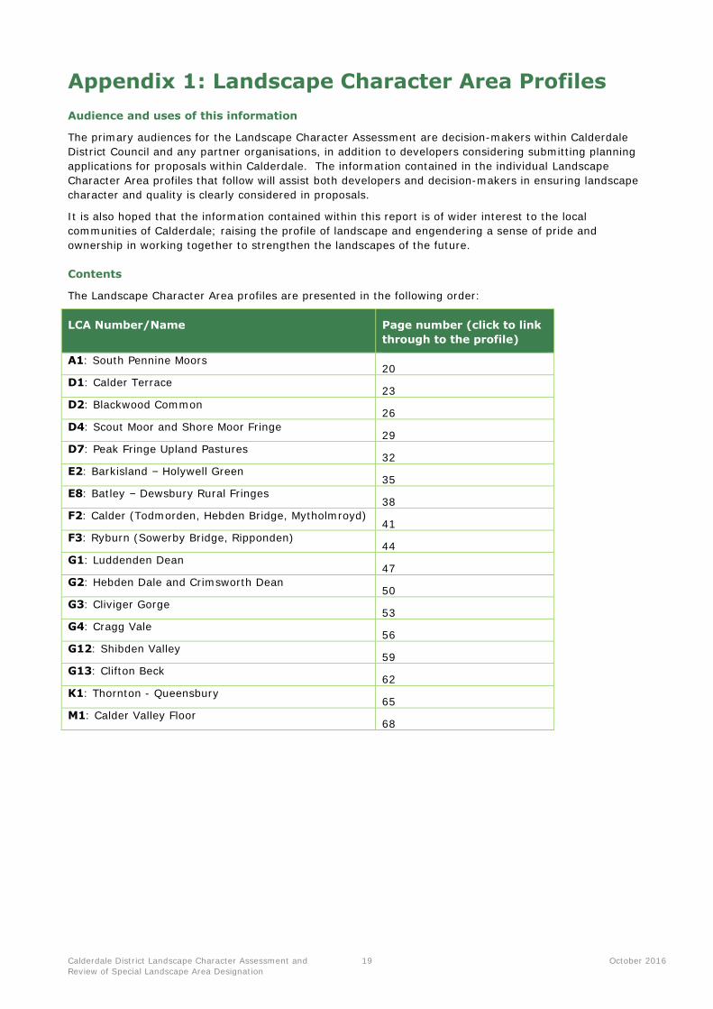
Appendix 1 : Landscape Character Area Profiles
Audience and uses of this information
The primary audiences for the Landscape Character Assessment are decision-makers within Calderdale
District Council and any partner organisations, in addition to developers considering submitting planning
applications for proposals within Calderdale. The information contained in the individual Landscape
Character Area profiles that follow will assist both developers and decision-makers in ensuring landscape
character and quality is clearly considered in proposals.
It is also hoped that the information contained within this report is of wider interest to the local
communities of Calderdale; raising the profile of landscape and engendering a sense of pride and
ownership in working together to strengthen the landscapes of the future.
Contents
The Landscape Character Area profiles are presented in the following order:
LCA Number/Name Page number (click to link
through to the profile)
A1: South Pennine Moors 20
D1: Calder Terrace 23
D2: Blackwood Common 26
D4: Scout Moor and Shore Moor Fringe 29
D7: Peak Fringe Upland Pastures 32
E2: Barkisland – Holywell Green 35
E8: Batley – Dewsbury Rural Fringes 38
F2: Calder (Todmorden, Hebden Bridge, Mytholmroyd) 41
F3: Ryburn (Sowerby Bridge, Ripponden) 44
G1: Luddenden Dean 47
G2: Hebden Dale and Crimsworth Dean 50
G3: Cliviger Gorge 53
G4: Cragg Vale 56
G12: Shibden Valley 59
G13: Clifton Beck 62
K1: Thornton - Queensbury 65
M1: Calder Valley Floor 68
Calderdale District Landscape Character Assessment and
Review of Special Landscape Area Designation
20 October 2016
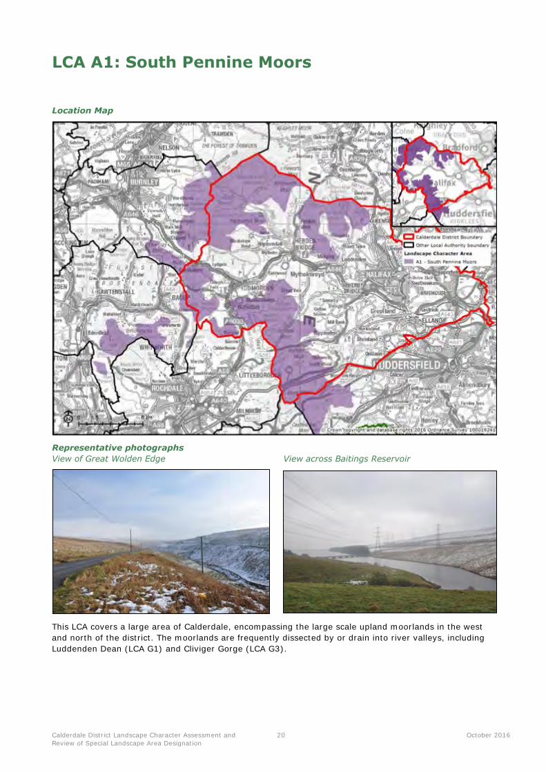
LCA A1: South Pennine Moors
Location Map
Representative photographs
View of Great Wolden Edge View across Baitings Reservoir
This LCA covers a large area of Calderdale, encompassing the large scale upland moorlands in the west
and north of the district. The moorlands are frequently dissected by or drain into river valleys, including
Luddenden Dean (LCA G1) and Cliviger Gorge (LCA G3).
Calderdale District Landscape Character Assessment and
Review of Special Landscape Area Designation
21 October 2016
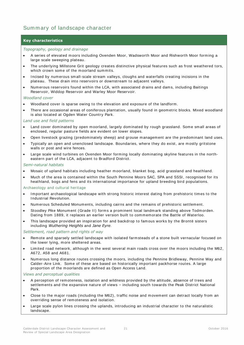
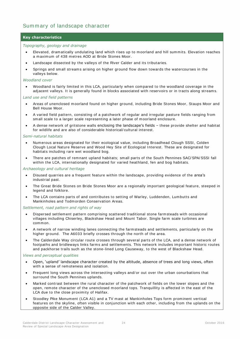
Summary of landscape character
Key characteristics
Topography, geology and drainage
A series of elevated moors including Ovenden Moor, Wadsworth Moor and Rishworth Moor forming a large scale sweeping plateau.
The underlying Millstone Grit geology creates distinctive physical features such as frost weathered tors, which crown some of the moorland summits.
Incised by numerous small-scale stream valleys, cloughs and waterfalls creating incisions in the plateau. These drain into reservoirs or downstream to adjacent valleys.
Numerous reservoirs found within the LCA, with associated drains and dams, including Baitings
Reservoir, Widdop Reservoir and Warley Moor Reservoir.
Woodland cover
Woodland cover is sparse owing to the elevation and exposure of the landform.
There are occasional areas of coniferous plantation, usually found in geometric blocks. Mixed woodland is also located at Ogden Water Country Park.
Land use and field patterns
Land cover dominated by open moorland, largely dominated by rough grassland. Some small areas of enclosed, regular pasture fields are evident on lower slopes.
Open livestock grazing (predominately sheep) and grouse management are the predominant land uses.
Typically an open and unenclosed landscape. Boundaries, where they do exist, are mostly gritstone walls or post and wire fences.
Large scale wind turbines on Ovenden Moor forming locally dominating skyline features in the north-eastern part of the LCA, adjacent to Bradford District.
Semi-natural habitats
Mosaic of upland habitats including heather moorland, blanket bog, acid grassland and heathland.
Much of the area is contained within the South Pennine Moors SAC, SPA and SSSI, recognised for its heathland, bogs and fens and its international importance for upland breeding bird populations.
Archaeology and cultural heritage
Important archaeological landscape with strong historic interest dating from prehistoric times to the Industrial Revolution.
Numerous Scheduled Monuments, including cairns and the remains of prehistoric settlement.
Stoodley Pike Monument (Grade II) forms a prominent local landmark standing above Todmorden. Dating from 1889, it replaces an earlier version built to commemorate the Battle of Waterloo.
This landscape provided an inspiration for and backdrop to famous works by the Brontë sisters
including Wuthering Heights and Jane Eyre.
Settlement, road pattern and rights of way
Remote and sparsely settled landscape with isolated farmsteads of a stone built vernacular focused on the lower lying, more sheltered areas.
Limited road network, although in the west several main roads cross over the moors including the M62, A672, A58 and A681.
Numerous long distance routes crossing the moors, including the Pennine Bridleway, Pennine Way and Calder-Aire Link. Some of these are based on historically important packhorse routes. A large proportion of the moorlands are defined as Open Access Land.
Views and perceptual qualities
A perception of remoteness, isolation and wildness provided by the altitude, absence of trees and settlements and the expansive nature of views – including south towards the Peak District National Park.
Close to the major roads (including the M62), traffic noise and movement can detract locally from an overriding sense of remoteness and isolation.
Large scale pylon lines crossing the uplands, introducing an industrial character to the naturalistic
landscape.
Calderdale District Landscape Character Assessment and
Review of Special Landscape Area Designation
22 October 2016
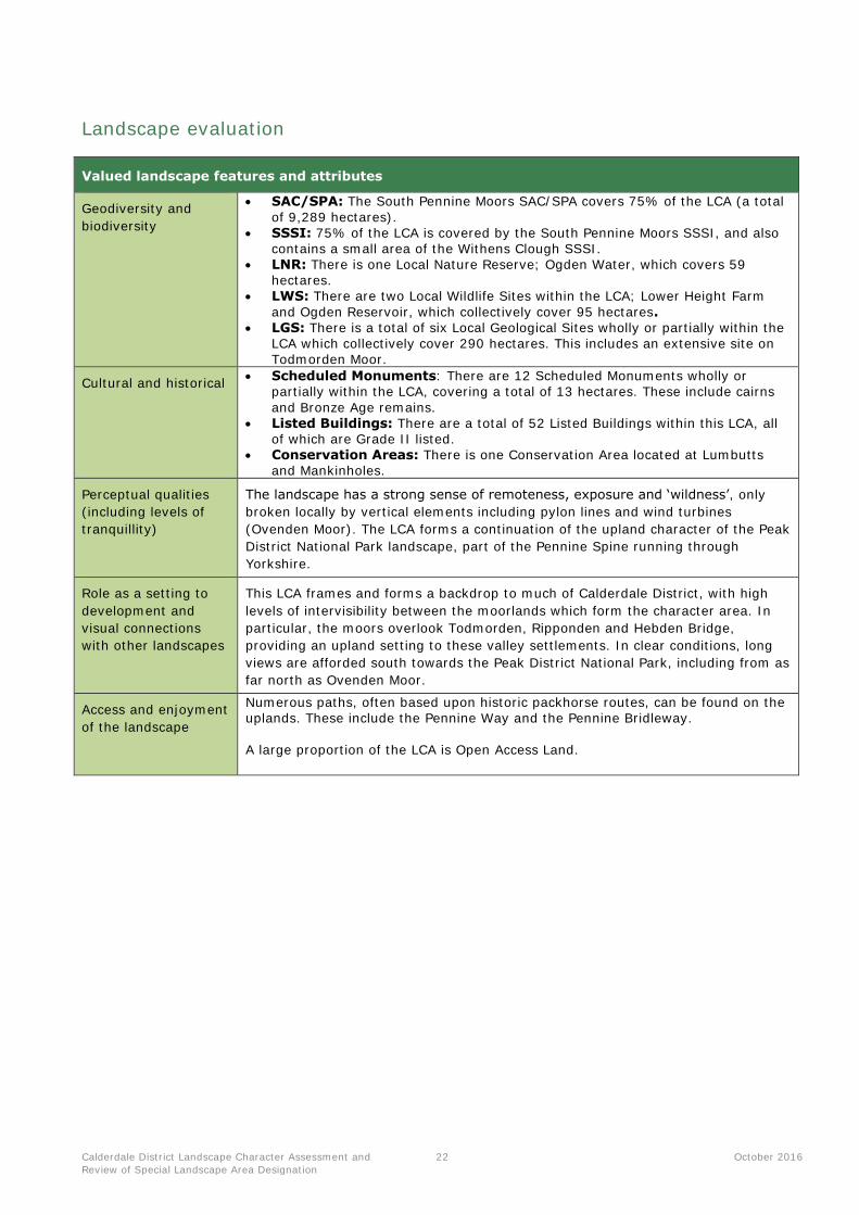
Landscape evaluation
Valued landscape features and attributes
Geodiversity and
biodiversity
SAC/SPA: The South Pennine Moors SAC/SPA covers 75% of the LCA (a total
of 9,289 hectares). SSSI: 75% of the LCA is covered by the South Pennine Moors SSSI, and also
contains a small area of the Withens Clough SSSI. LNR: There is one Local Nature Reserve; Ogden Water, which covers 59
hectares. LWS: There are two Local Wildlife Sites within the LCA; Lower Height Farm
and Ogden Reservoir, which collectively cover 95 hectares. LGS: There is a total of six Local Geological Sites wholly or partially within the
LCA which collectively cover 290 hectares. This includes an extensive site on Todmorden Moor.
Cultural and historical Scheduled Monuments: There are 12 Scheduled Monuments wholly or
partially within the LCA, covering a total of 13 hectares. These include cairns
and Bronze Age remains. Listed Buildings: There are a total of 52 Listed Buildings within this LCA, all
of which are Grade II listed. Conservation Areas: There is one Conservation Area located at Lumbutts
and Mankinholes.
Perceptual qualities
(including levels of
tranquillity)
The landscape has a strong sense of remoteness, exposure and ‘wildness’, only
broken locally by vertical elements including pylon lines and wind turbines
(Ovenden Moor). The LCA forms a continuation of the upland character of the Peak
District National Park landscape, part of the Pennine Spine running through
Yorkshire.
Role as a setting to
development and
visual connections
with other landscapes
This LCA frames and forms a backdrop to much of Calderdale District, with high
levels of intervisibility between the moorlands which form the character area. In
particular, the moors overlook Todmorden, Ripponden and Hebden Bridge,
providing an upland setting to these valley settlements. In clear conditions, long
views are afforded south towards the Peak District National Park, including from as
far north as Ovenden Moor.
Access and enjoyment
of the landscape
Numerous paths, often based upon historic packhorse routes, can be found on the uplands. These include the Pennine Way and the Pennine Bridleway.
A large proportion of the LCA is Open Access Land.
Calderdale District Landscape Character Assessment and
Review of Special Landscape Area Designation
23 October 2016
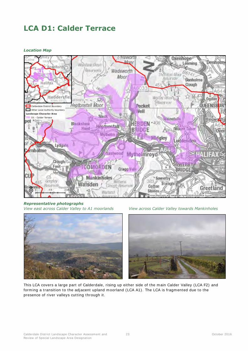
LCA D1: Calder Terrace
Location Map
Representative photographs
View east across Calder Valley to A1 moorlands View across Calder Valley towards Mankinholes
This LCA covers a large part of Calderdale, rising up either side of the main Calder Valley (LCA F2) and
forming a transition to the adjacent upland moorland (LCA A1). The LCA is fragmented due to the
presence of river valleys cutting through it.
Calderdale District Landscape Character Assessment and
Review of Special Landscape Area Designation
24 October 2016
Summary of landscape character
Key characteristics
Topography, geology and drainage
Elevated, dramatically undulating land which rises up to moorland and hill summits. Elevation reaches
a maximum of 438 metres AOD at Bride Stones Moor.
Landscape dissected by the valleys of the River Calder and its tributaries.
Springs and small streams arising on higher ground flow down towards the watercourses in the valleys below.
Woodland cover
Woodland is fairly limited in this LCA, particularly when compared to the woodland coverage in the adjacent valleys. It is generally found in blocks associated with reservoirs or in tracts along streams.
Land use and field patterns
Areas of unenclosed moorland found on higher ground, including Bride Stones Moor, Staups Moor and Bell House Moor.
A varied field pattern, consisting of a patchwork of regular and irregular pasture fields ranging from small scale to a larger scale representing a later phase of moorland enclosure.
A dense network of gritstone walls enclosing the landscape’s fields – these provide shelter and habitat for wildlife and are also of considerable historical/cultural interest.
Semi-natural habitats
Numerous areas designated for their ecological value, including Broadhead Clough SSSI, Colden
Clough Local Nature Reserve and Wood Hey Site of Ecological Interest. These are designated for habitats including rare wet woodland bog.
There are patches of remnant upland habitats; small parts of the South Pennines SAC/SPA/SSSI fall
within the LCA, internationally designated for varied heathland, fen and bog habitats.
Archaeology and cultural heritage
Disused quarries are a frequent feature within the landscape, providing evidence of the area’s
industrial past.
The Great Bride Stones on Bride Stones Moor are a regionally important geological feature, steeped in
legend and folklore.
The LCA contains parts of and contributes to setting of Warley, Luddenden, Lumbutts and
Mankinholes and Todmorden Conservation Areas.
Settlement, road pattern and rights of way
Dispersed settlement pattern comprising scattered traditional stone farmsteads with occasional villages including Chiserley, Blackshaw Head and Mount Tabor. Single farm scale turbines are
common.
A network of narrow winding lanes connecting the farmsteads and settlements, particularly on the
higher ground. The A6033 briefly crosses through the north of the area.
The Calderdale Way circular route crosses through several parts of the LCA, and a dense network of footpaths and bridleways links farms and settlements. This network includes important historic routes
and packhorse trails such as the stone-lined Long Causeway, to the west of Blackshaw Head.
Views and perceptual qualities
Open, ‘upland’ landscape character created by the altitude, absence of trees and long views, often with a sense of remoteness and isolation.
Frequent long views across the intersecting valleys and/or out over the urban conurbations that surround the South Pennines uplands.
Marked contrast between the rural character of the patchwork of fields on the lower slopes and the
open, remote character of the unenclosed moorland tops. Tranquillity is affected in the east of the LCA due to the close proximity of Halifax.
Stoodley Pike Monument (LCA A1) and a TV mast at Mankinholes Tops form prominent vertical features on the skyline, often visible in conjunction with each other, including from the uplands on the
opposite side of the Calder Valley.
Calderdale District Landscape Character Assessment and
Review of Special Landscape Area Designation
25 October 2016
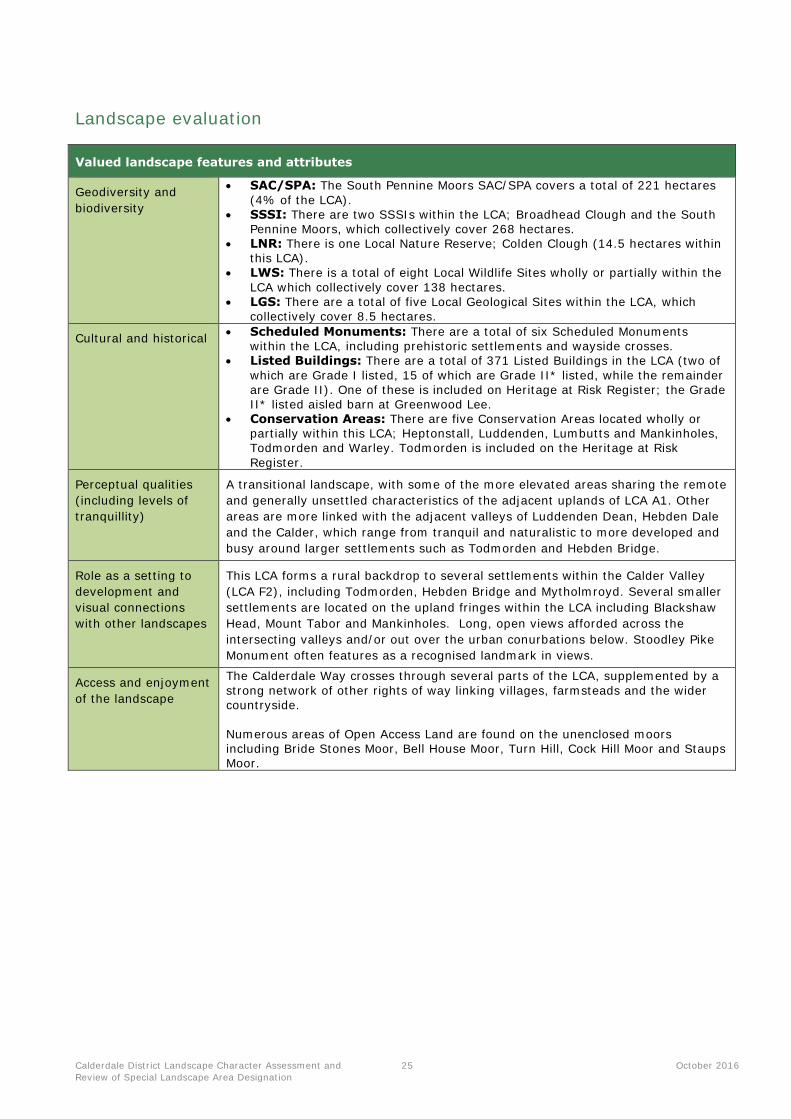
Landscape evaluation
Valued landscape features and attributes
Geodiversity and
biodiversity
SAC/SPA: The South Pennine Moors SAC/SPA covers a total of 221 hectares
(4% of the LCA). SSSI: There are two SSSIs within the LCA; Broadhead Clough and the South
Pennine Moors, which collectively cover 268 hectares. LNR: There is one Local Nature Reserve; Colden Clough (14.5 hectares within
this LCA). LWS: There is a total of eight Local Wildlife Sites wholly or partially within the
LCA which collectively cover 138 hectares. LGS: There are a total of five Local Geological Sites within the LCA, which
collectively cover 8.5 hectares.
Cultural and historical Scheduled Monuments: There are a total of six Scheduled Monuments
within the LCA, including prehistoric settlements and wayside crosses. Listed Buildings: There are a total of 371 Listed Buildings in the LCA (two of
which are Grade I listed, 15 of which are Grade II* listed, while the remainder are Grade II). One of these is included on Heritage at Risk Register; the Grade II* listed aisled barn at Greenwood Lee.
Conservation Areas: There are five Conservation Areas located wholly or partially within this LCA; Heptonstall, Luddenden, Lumbutts and Mankinholes, Todmorden and Warley. Todmorden is included on the Heritage at Risk
Register.
Perceptual qualities
(including levels of
tranquillity)
A transitional landscape, with some of the more elevated areas sharing the remote
and generally unsettled characteristics of the adjacent uplands of LCA A1. Other
areas are more linked with the adjacent valleys of Luddenden Dean, Hebden Dale
and the Calder, which range from tranquil and naturalistic to more developed and
busy around larger settlements such as Todmorden and Hebden Bridge.
Role as a setting to
development and
visual connections
with other landscapes
This LCA forms a rural backdrop to several settlements within the Calder Valley
(LCA F2), including Todmorden, Hebden Bridge and Mytholmroyd. Several smaller
settlements are located on the upland fringes within the LCA including Blackshaw
Head, Mount Tabor and Mankinholes. Long, open views afforded across the
intersecting valleys and/or out over the urban conurbations below. Stoodley Pike
Monument often features as a recognised landmark in views.
Access and enjoyment
of the landscape
The Calderdale Way crosses through several parts of the LCA, supplemented by a
strong network of other rights of way linking villages, farmsteads and the wider countryside.
Numerous areas of Open Access Land are found on the unenclosed moors including Bride Stones Moor, Bell House Moor, Turn Hill, Cock Hill Moor and Staups Moor.
Calderdale District Landscape Character Assessment and
Review of Special Landscape Area Designation
26 October 2016
LCA D2: Blackwood Common
Location Map
Representative photographs
View east from Wholestone Hill View south from New Road towards uplands
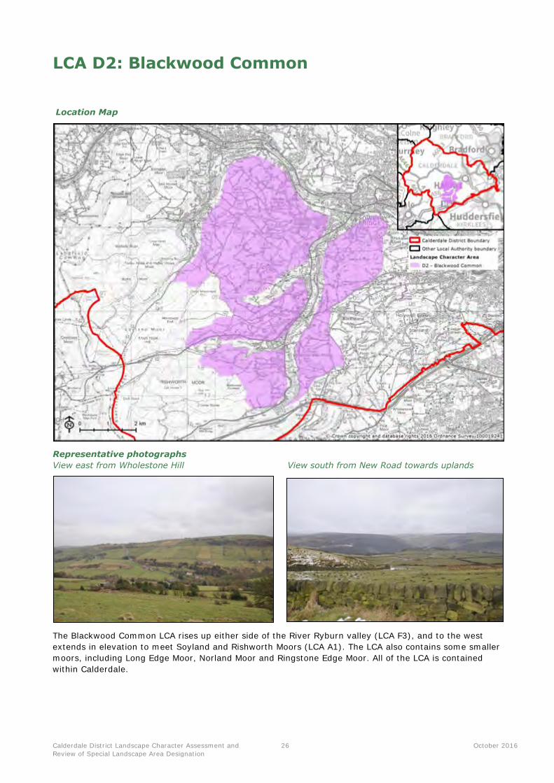
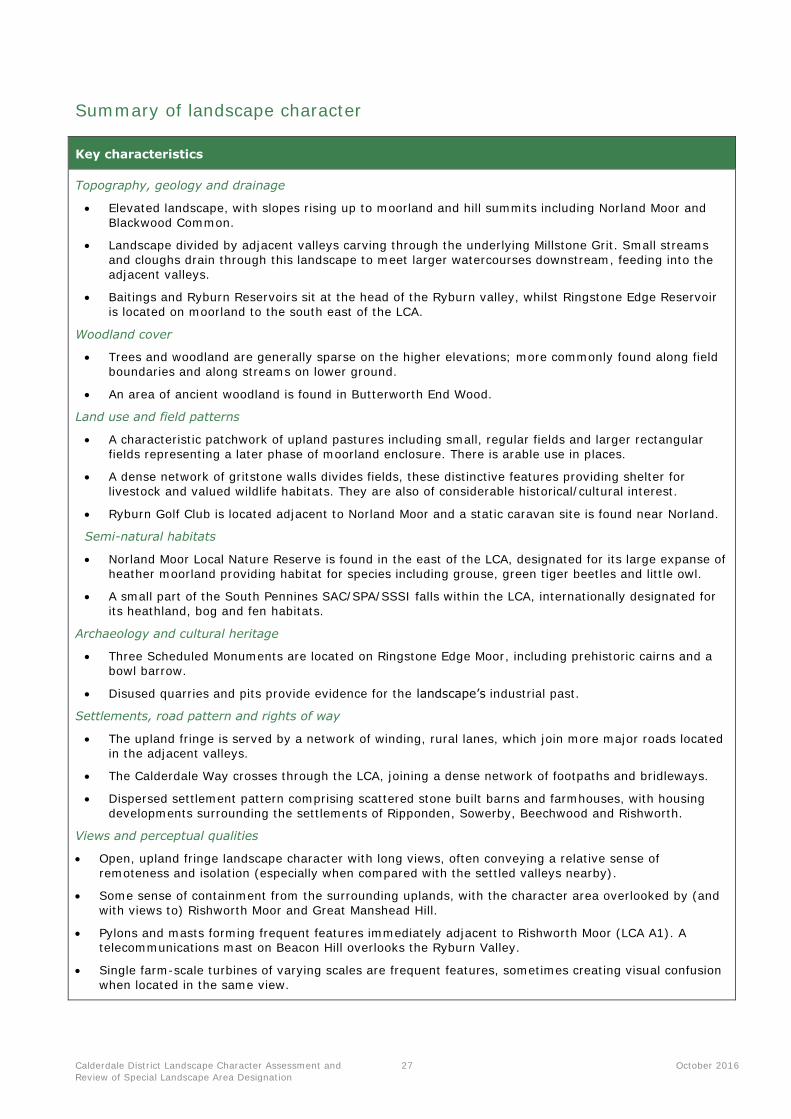
The Blackwood Common LCA rises up either side of the River Ryburn valley (LCA F3), and to the west
extends in elevation to meet Soyland and Rishworth Moors (LCA A1). The LCA also contains some smaller
moors, including Long Edge Moor, Norland Moor and Ringstone Edge Moor. All of the LCA is contained
within Calderdale.
Calderdale District Landscape Character Assessment and
Review of Special Landscape Area Designation
27 October 2016
Summary of landscape character
Key characteristics
Topography, geology and drainage
Elevated landscape, with slopes rising up to moorland and hill summits including Norland Moor and
Blackwood Common.
Landscape divided by adjacent valleys carving through the underlying Millstone Grit. Small streams
and cloughs drain through this landscape to meet larger watercourses downstream, feeding into the
adjacent valleys.
Baitings and Ryburn Reservoirs sit at the head of the Ryburn valley, whilst Ringstone Edge Reservoir
is located on moorland to the south east of the LCA.
Woodland cover
Trees and woodland are generally sparse on the higher elevations; more commonly found along field
boundaries and along streams on lower ground.
An area of ancient woodland is found in Butterworth End Wood.
Land use and field patterns
A characteristic patchwork of upland pastures including small, regular fields and larger rectangular
fields representing a later phase of moorland enclosure. There is arable use in places.
A dense network of gritstone walls divides fields, these distinctive features providing shelter for
livestock and valued wildlife habitats. They are also of considerable historical/cultural interest.
Ryburn Golf Club is located adjacent to Norland Moor and a static caravan site is found near Norland.
Semi-natural habitats
Norland Moor Local Nature Reserve is found in the east of the LCA, designated for its large expanse of
heather moorland providing habitat for species including grouse, green tiger beetles and little owl.
A small part of the South Pennines SAC/SPA/SSSI falls within the LCA, internationally designated for
its heathland, bog and fen habitats.
Archaeology and cultural heritage
Three Scheduled Monuments are located on Ringstone Edge Moor, including prehistoric cairns and a
bowl barrow.
Disused quarries and pits provide evidence for the landscape’s industrial past.
Settlements, road pattern and rights of way
The upland fringe is served by a network of winding, rural lanes, which join more major roads located
in the adjacent valleys.
The Calderdale Way crosses through the LCA, joining a dense network of footpaths and bridleways.
Dispersed settlement pattern comprising scattered stone built barns and farmhouses, with housing
developments surrounding the settlements of Ripponden, Sowerby, Beechwood and Rishworth.
Views and perceptual qualities
Open, upland fringe landscape character with long views, often conveying a relative sense of
remoteness and isolation (especially when compared with the settled valleys nearby).
Some sense of containment from the surrounding uplands, with the character area overlooked by (and
with views to) Rishworth Moor and Great Manshead Hill.
Pylons and masts forming frequent features immediately adjacent to Rishworth Moor (LCA A1). A
telecommunications mast on Beacon Hill overlooks the Ryburn Valley.
Single farm-scale turbines of varying scales are frequent features, sometimes creating visual confusion
when located in the same view.

Calderdale District Landscape Character Assessment and
Review of Special Landscape Area Designation
28 October 2016
Landscape evaluation
Valued landscape features and attributes
Geodiversity and
biodiversity
SAC/SPA/SSSI: The South Pennine Moors SAC/SPA/SSSI covers a total of 39
hectares. LNR: There is one Local Nature Reserve; Norland Moor, which covers 91.8
hectares. LWS: There are three Local Wildlife Sites wholly or partially within the LCA;
Booth Wood and Turner Wood, Norland Moor and Rough Hey Wood. These collectively cover 114 hectares.
Cultural and historical Scheduled Monument: There are four Scheduled Monuments within the LCA,
including the Cairnfield on Ringstone Edge Moor which is also on the Heritage
at Risk Register. Listed Buildings: There are a total of 205 Listed Buildings in the LCA (two of
which are Grade I, ten of which are Grade II*, while the remainder are Grade II listed). One of these is included on the Heritage at Risk Register, the Grade
I listed Church of St Peter in Halifax. Conservation Areas: There is one Conservation Area located within Mill Bank
and Cottonstones.
Perceptual qualities
(including levels of
tranquillity)
The LCA has a predominantly rural character with sparse development, although in
places this is impacted upon by pylons and small wind turbines. Adjacent to the
uplands of LCA A1, there is a transition to a more upland character.
Role as a setting to
development and
visual connections
with other landscapes
The LCA forms an immediate upland fringe setting to several small villages
including Rishworth, Triangle, Sowerby and Beechwood. Additionally, it forms a
rural and undeveloped backdrop to the larger settlements of Sowerby Bridge and
Ripponden (including its Conservation Area). The LCA’s open character and
elevation affords strong intervisibility with the Ryburn Valley below, as well as the
nearby uplands of Rishworth Moor and Great Manshead Hill.
Access and enjoyment
of the landscape
The rural areas are crossed by a dense network of footpaths and bridleways, including the long distance Calderdale Way. There are several areas of Open Access Land, including adjacent to the moors
within LCA A1 and Norland Moor.
Calderdale District Landscape Character Assessment and
Review of Special Landscape Area Designation
29 October 2016
LCA D4: Scout Moor and Shore Moor Fringe
Location Map
Representative photographs
View south-east towards Todmorden Fields with rush pasture and gritstone walls
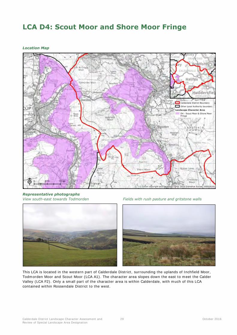
This LCA is located in the western part of Calderdale District, surrounding the uplands of Inchfield Moor,
Todmorden Moor and Scout Moor (LCA A1). The character area slopes down the east to meet the Calder
Valley (LCA F2). Only a small part of the character area is within Calderdale, with much of this LCA
contained within Rossendale District to the west.

Calderdale District Landscape Character Assessment and
Review of Special Landscape Area Designation
30 October 2016
Summary of landscape character
Key characteristics
Topography, geology and drainage
Elevated and open upland fringe landscape rising up to the surrounding moors, including Walsden
Moor, Shore Moor and Todmorden Moor.
Numerous springs found on higher ground, carving through the landscape to drain into the larger
streams and rivers in the surrounding valleys.
Woodland cover
Limited woodland cover on higher ground due to its elevation and exposure.
In contrast, dense broadleaved woodland cloaks the steep slopes which grade down to the adjacent
valleys.
Land use and field patterns
A characteristic strong patchwork pattern of upland pastures including small irregular fields and larger
rectilinear fields representing a later phase of moorland enclosure.
A dense network of characteristic gritstone walls marks the fields, supplemented by wire fences. The
stone walls are of considerable biodiversity and cultural interest.
At higher elevations on the edge of the open moors, land is often unenclosed and under rough livestock grazing (predominantly sheep).
Semi-natural habitats
Fragmented unimproved upland pastures including colourful species-rich hay meadows and rush pastures, along with remnant moorland habitats.
A small part of the Gorpley Clough Local Nature Reserve is found in the LCA.
Archaeology and cultural heritage
The Grade II* Listed Dobroyd Castle occupies a prominent position overlooking Todmorden.
Hummocky mounds associated with past mining activity form frequent features on the upland fringes.
Centre Vale Park in Todmorden is recognised for its local importance.
The LCA provides a key part of the rural setting to Todmorden Conservation Area.
Settlement, road pattern and rights of way
Dispersed settlement pattern comprising scattered traditional gritstone farmsteads, cottages and
detached modern sandstone dwellings, along with small rows of 19th century terraces. Settlement is
more apparent on the fringes of Todmorden.
Roads are sparse, and generally consist of narrow winding lanes connecting the farmsteads and settlements. Stone walls often tightly bound the lanes.
The long distance tracks of the Calderdale Way and the Todmorden Centenary Way cross through the
LCA, supplemented by a dense network of footpaths and bridleways.
Views and perceptual qualities
High levels of intervisibility with the Calder Valley (LCA F2), across to the upland fringes and uplands
(LCA D1 and D4). These views include the prominent skyline feature of Stoodley Pike Monument.
There is a sense of remoteness and isolation, particularly on the higher moorland fringes. The LCA has
strong visual connections with the surrounding uplands of Flower Scar Hill, Oatley Hill and Shore Moor.
Several telecommunications masts punctuate the open skyline. There are also clear views of the
moving turbines of Coal Clough wind farm (within the adjacent Burnley district).

Calderdale District Landscape Character Assessment and
Review of Special Landscape Area Designation
31 October 2016
Landscape evaluation
Valued landscape features and attributes
Geodiversity and
biodiversity
LNR: A small part of the Gorpley Clough LNR falls within this LCA, although
most is contained within LCA F2. LWS: The LCA wholly or partially contains three Local Wildlife Sites; Gorpley
Clough, Ramsden Clough and the Rochdale Canal which collectively cover 8 hectares.
LGS: Two Local Geological Sites are found within this LCA; Gorpley Clough and Todmorden Moor, which cover nearly 23 hectares.
Cultural and historical Listed Buildings: There are a total of 45 Listed Buildings in the LCA (one of
which is Grade II* listed, while the remainder are Grade II).
Conservation Areas: There is one Conservation Area located within Todmorden, which is also included on the Heritage at Risk Register. It covers 30 hectares within the LCA.
Perceptual qualities
(including levels of
tranquillity)
Immediately adjacent to the moorland uplands of LCA A1, the landscape feels
remote and exposed. As the upland fringe slopes down into the valley, it becomes
more enclosed with lower levels of remoteness as a result of the nearby urban
development and transport corridors along the Calder Valley (LCA F2). The dense
woodland found on some of the slopes surrounding the valley can have a diluting
effect on these urban influences.
Role as a setting to
development and
visual connections
with other landscapes
The LCA forms part of the elevated upland backdrop to the settlement of
Todmorden (including its Conservation Area), located in the Calder Valley below. It
also forms part of the setting to Walsden, Bottomley, Ramsden Wood and
Robinswood. Elevation means there are high levels of intervisibility with adjacent
landscapes, including the Calder Valley below and across to the adjacent uplands.
These views often feature the landmark of Stoodley Pike Monument.
Access and enjoyment
of the landscape
Numerous footpaths and bridleways cross the LCA, including parts of the Calderdale Way. There are some patches of Open Access Land within the LCA,
particularly in the south next to Shore Moor.
Calderdale District Landscape Character Assessment and
Review of Special Landscape Area Designation
32 October 2016
LCA D7: Peak Fringe Upland Pastures
Location Map
Representative photographs
View across to Rishworth Moor View northeast towards Ripponden
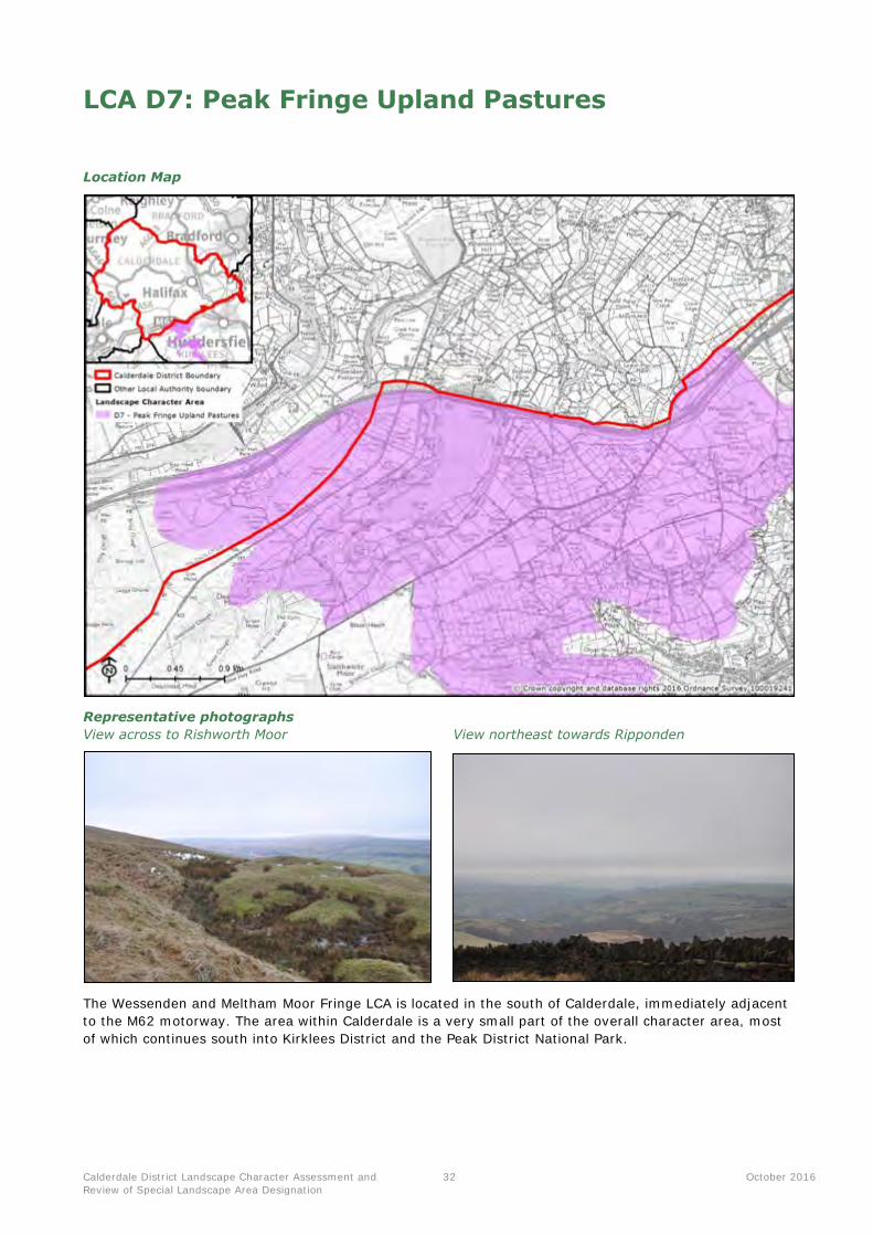
The Wessenden and Meltham Moor Fringe LCA is located in the south of Calderdale, immediately adjacent
to the M62 motorway. The area within Calderdale is a very small part of the overall character area, most
of which continues south into Kirklees District and the Peak District National Park.
Calderdale District Landscape Character Assessment and
Review of Special Landscape Area Designation
33 October 2016
Summary of landscape character
Key characteristics
Topography, geology and drainage
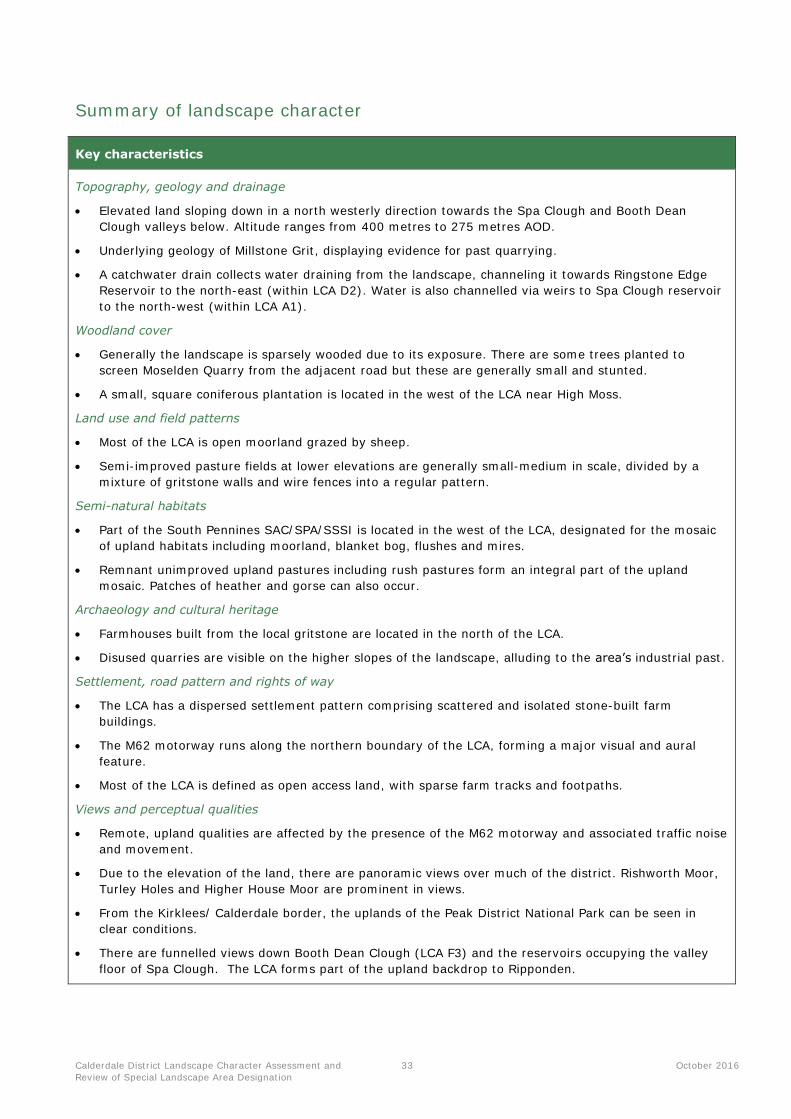
Elevated land sloping down in a north westerly direction towards the Spa Clough and Booth Dean
Clough valleys below. Altitude ranges from 400 metres to 275 metres AOD.
Underlying geology of Millstone Grit, displaying evidence for past quarrying.
A catchwater drain collects water draining from the landscape, channeling it towards Ringstone Edge
Reservoir to the north-east (within LCA D2). Water is also channelled via weirs to Spa Clough reservoir
to the north-west (within LCA A1).
Woodland cover
Generally the landscape is sparsely wooded due to its exposure. There are some trees planted to
screen Moselden Quarry from the adjacent road but these are generally small and stunted.
A small, square coniferous plantation is located in the west of the LCA near High Moss.
Land use and field patterns
Most of the LCA is open moorland grazed by sheep.
Semi-improved pasture fields at lower elevations are generally small-medium in scale, divided by a
mixture of gritstone walls and wire fences into a regular pattern.
Semi-natural habitats
Part of the South Pennines SAC/SPA/SSSI is located in the west of the LCA, designated for the mosaic
of upland habitats including moorland, blanket bog, flushes and mires.
Remnant unimproved upland pastures including rush pastures form an integral part of the upland
mosaic. Patches of heather and gorse can also occur.
Archaeology and cultural heritage
Farmhouses built from the local gritstone are located in the north of the LCA.
Disused quarries are visible on the higher slopes of the landscape, alluding to the area’s industrial past.
Settlement, road pattern and rights of way
The LCA has a dispersed settlement pattern comprising scattered and isolated stone-built farm
buildings.
The M62 motorway runs along the northern boundary of the LCA, forming a major visual and aural
feature.
Most of the LCA is defined as open access land, with sparse farm tracks and footpaths.
Views and perceptual qualities
Remote, upland qualities are affected by the presence of the M62 motorway and associated traffic noise
and movement.
Due to the elevation of the land, there are panoramic views over much of the district. Rishworth Moor,
Turley Holes and Higher House Moor are prominent in views.
From the Kirklees/ Calderdale border, the uplands of the Peak District National Park can be seen in
clear conditions.
There are funnelled views down Booth Dean Clough (LCA F3) and the reservoirs occupying the valley
floor of Spa Clough. The LCA forms part of the upland backdrop to Ripponden.

Calderdale District Landscape Character Assessment and
Review of Special Landscape Area Designation
34 October 2016
Landscape evaluation
Valued landscape features and attributes
Geodiversity and
biodiversity
SAC/SPA/SSSI: The South Pennine Moors SAC/SPA/SSSI is partially within
the LCA and covers 20 hectares (15.8% of the LCA).
Cultural and historical N/A – there are no national or local designations relating to features of cultural or heritage significance within this LCA.
Perceptual qualities
(including levels of
tranquillity)
A typical upland moorland landscape character, although expected qualities of
remoteness are eroded by traffic noise and movement from the M62 which forms
the northern boundary of the LCA.
Role as a setting to
development and
visual connections
with other landscapes
This LCA forms part of the dramatic upland backdrop to several settlements in the
district, particularly Ripponden and Barkisland.
Long views across large tracts of Calderdale District are afforded by the height of
the land, including from the local authority boundary to the south across the
moorlands of Kirklees to the Peak District National Park (collectively combining to
produce a large expanse of moorland character flowing across authority
boundaries).
Access and enjoyment
of the landscape
Much of the LCA is Open Access Land, with several footpaths and tracks crossing the moorland.

Calderdale District Landscape Character Assessment and
Review of Special Landscape Area Designation
35 October 2016
LCA E2: Barkisland – Holywell Green
Location Map
Representative photographs
Black Brook valley with smoke plume View across landscape south of Greetland
This LCA is located in the south east of Calderdale, and comprises the rural fringes to the west of Elland, incorporating the settlements of Greetland and Holywell Green. The LCA continues south-east into
Kirklees District.
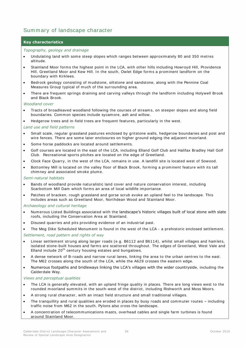
Calderdale District Landscape Character Assessment and
Review of Special Landscape Area Designation
36 October 2016
Summary of landscape character
Key characteristics
Topography, geology and drainage
Undulating land with some steep slopes which ranges between approximately 80 and 350 metres altitude.
Stainland Moor forms the highest point in the LCA, with other hills including Howroyd Hill, Providence Hill, Greetland Moor and Kew Hill. In the south, Owlet Edge forms a prominent landform on the boundary with Kirklees.
Bedrock geology consisting of mudstone, siltstone and sandstone, along with the Pennine Coal Measures Group typical of much of the surrounding area.
There are frequent springs draining and carving valleys through the landform including Holywell Brook
and Black Brook.
Woodland cover
Tracts of broadleaved woodland following the courses of streams, on steeper slopes and along field boundaries. Common species include sycamore, ash and willow.
Hedgerow trees and in-field trees are frequent features, particularly in the west.
Land use and field patterns
Small scale, regular grassland pastures enclosed by gritstone walls, hedgerow boundaries and post and wire fences. There are some later enclosures on higher ground edging the adjacent moorland.
Some horse paddocks are located around settlements.
Golf courses are located in the east of the LCA, including Elland Golf Club and Halifax Bradley Hall Golf Club. Recreational sports pitches are located on the edge of Greetland.
Clock Face Quarry, in the west of the LCA, remains in use. A landfill site is located west of Sowood.
Bottomley Mill is located on the valley floor of Black Brook, forming a prominent feature with its tall chimney and associated smoke plume.
Semi-natural habitats
Bands of woodland provide naturalistic land cover and nature conservation interest, including Scarbottom Mill Dam which forms an area of local wildlife importance.
Patches of bracken, rough grassland and gorse scrub evoke an upland feel to the landscape. This includes areas such as Greetland Moor, Northdean Wood and Stainland Moor.
Archaeology and cultural heritage
Numerous Listed Buildings associated with the landscape’s historic villages built of local stone with slate roofs, including the Conservation Area at Stainland.
Disused quarries and pits providing evidence of an industrial past.
The Meg Dike Scheduled Monument is found in the west of the LCA - a prehistoric enclosed settlement.
Settlement, road pattern and rights of way
Linear settlement strung along larger roads (e.g. B6112 and B6114), whilst small villages and hamlets, isolated stone-built houses and farms are scattered throughout. The edges of Greetland, West Vale and
Elland include 20th century housing estates and bungalows.
A dense network of B-roads and narrow rural lanes, linking the area to the urban centres to the east. The M62 crosses along the south of the LCA, while the A629 crosses the eastern edge.
Numerous footpaths and bridleways linking the LCA’s villages with the wider countryside, including the Calderdale Way.
Views and perceptual qualities
The LCA is generally elevated, with an upland fringe quality in places. There are long views west to the rounded moorland summits in the south-west of the district, including Rishworth and Moss Moors.
A strong rural character, with an intact field structure and small traditional villages.
The tranquillity and rural qualities are eroded in places by busy roads and commuter routes – including traffic noise from M62 in the south. Pylons also cross the landscape.
A concentration of telecommunications masts, overhead cables and single farm turbines is found around Stainland Moor.
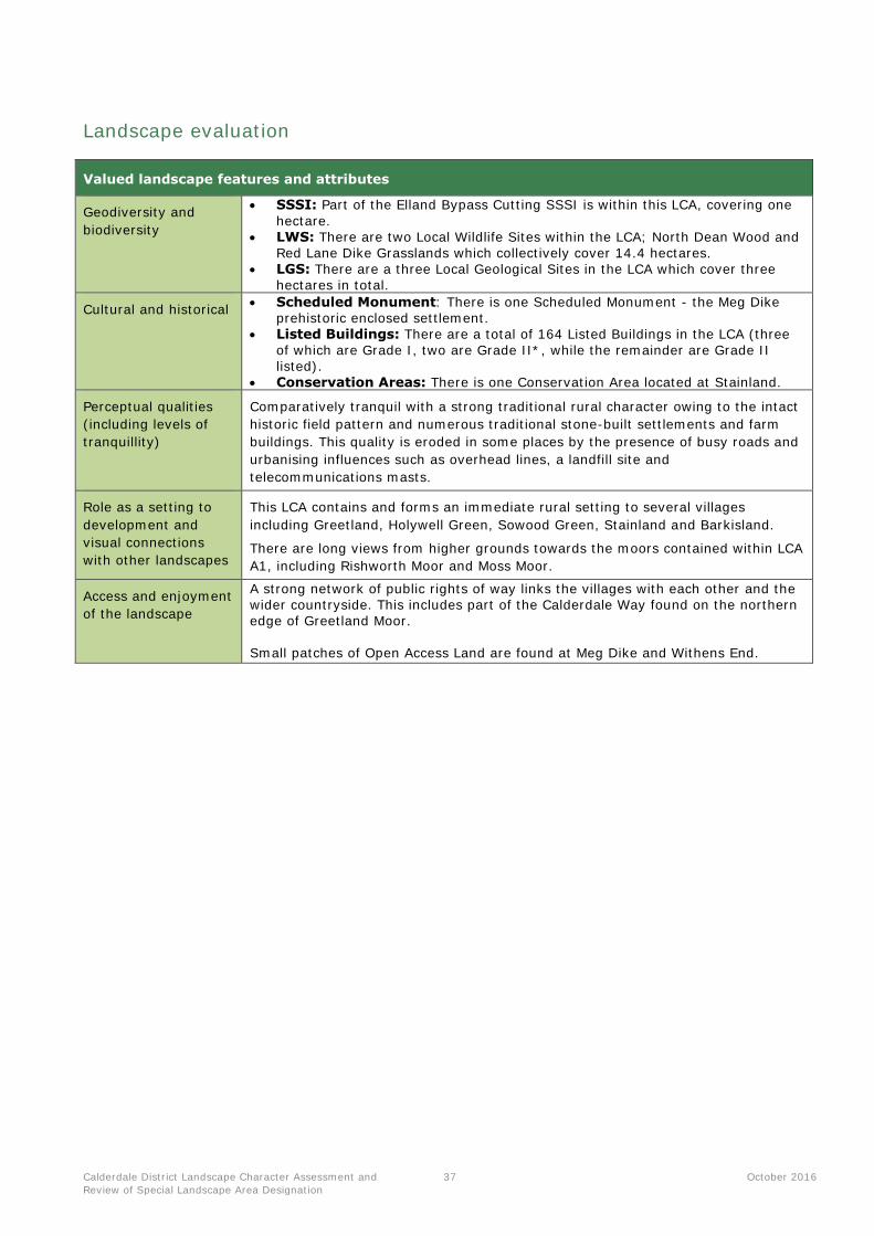
Calderdale District Landscape Character Assessment and
Review of Special Landscape Area Designation
37 October 2016
Landscape evaluation
Valued landscape features and attributes
Geodiversity and
biodiversity
SSSI: Part of the Elland Bypass Cutting SSSI is within this LCA, covering one
hectare. LWS: There are two Local Wildlife Sites within the LCA; North Dean Wood and
Red Lane Dike Grasslands which collectively cover 14.4 hectares. LGS: There are a three Local Geological Sites in the LCA which cover three
hectares in total.
Cultural and historical Scheduled Monument: There is one Scheduled Monument - the Meg Dike
prehistoric enclosed settlement. Listed Buildings: There are a total of 164 Listed Buildings in the LCA (three
of which are Grade I, two are Grade II*, while the remainder are Grade II listed).
Conservation Areas: There is one Conservation Area located at Stainland.
Perceptual qualities
(including levels of
tranquillity)
Comparatively tranquil with a strong traditional rural character owing to the intact
historic field pattern and numerous traditional stone-built settlements and farm
buildings. This quality is eroded in some places by the presence of busy roads and
urbanising influences such as overhead lines, a landfill site and
telecommunications masts.
Role as a setting to
development and
visual connections
with other landscapes
This LCA contains and forms an immediate rural setting to several villages
including Greetland, Holywell Green, Sowood Green, Stainland and Barkisland.
There are long views from higher grounds towards the moors contained within LCA
A1, including Rishworth Moor and Moss Moor.
Access and enjoyment
of the landscape
A strong network of public rights of way links the villages with each other and the wider countryside. This includes part of the Calderdale Way found on the northern edge of Greetland Moor. Small patches of Open Access Land are found at Meg Dike and Withens End.
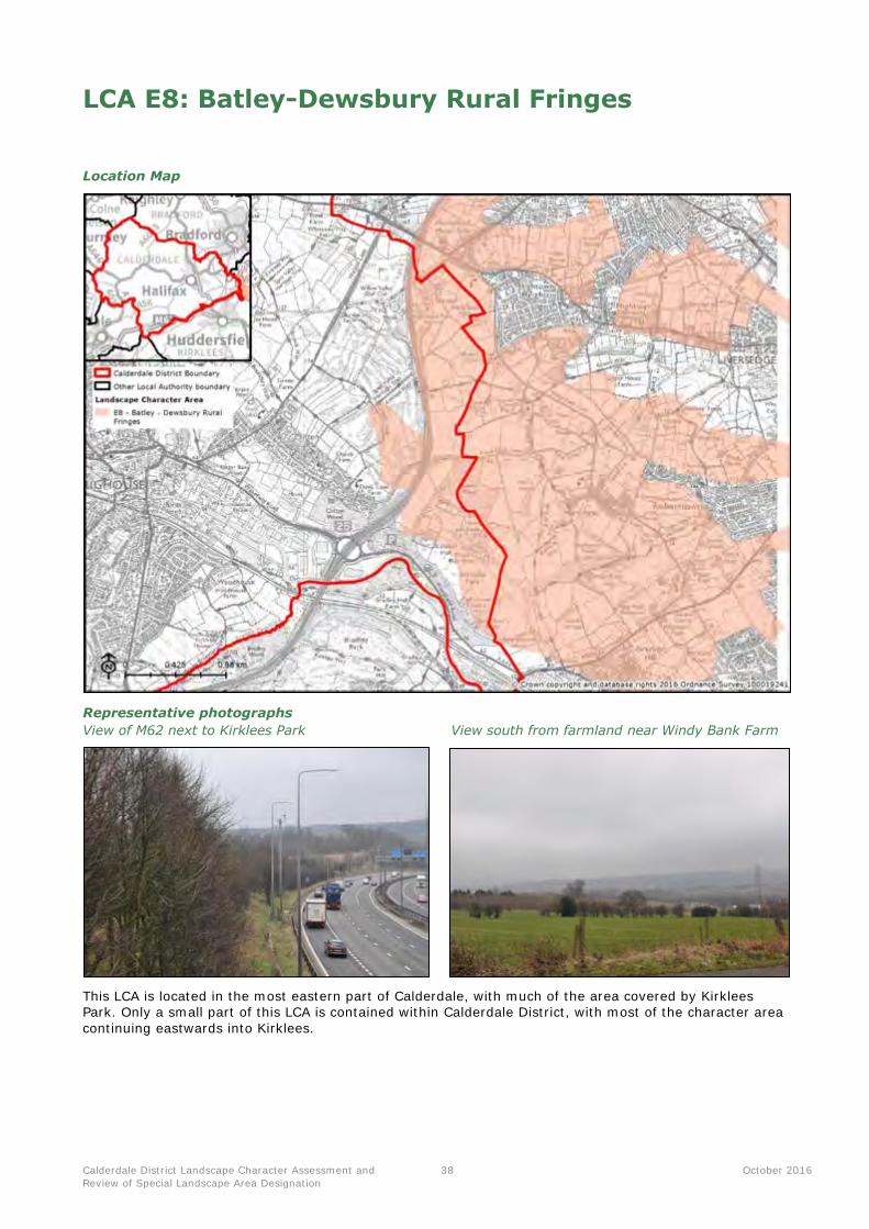
Calderdale District Landscape Character Assessment and
Review of Special Landscape Area Designation
38 October 2016
LCA E8: Batley-Dewsbury Rural Fringes
Location Map
Representative photographs
View of M62 next to Kirklees Park View south from farmland near Windy Bank Farm
This LCA is located in the most eastern part of Calderdale, with much of the area covered by Kirklees Park. Only a small part of this LCA is contained within Calderdale District, with most of the character area
continuing eastwards into Kirklees.

Calderdale District Landscape Character Assessment and
Review of Special Landscape Area Designation
39 October 2016
Summary of landscape character
Key characteristics
Topography, geology and drainage
Gently undulating land, found between approximately 70 and 150 metres altitude. The land typically
falls in elevation in the south towards the River Calder.
Bedrock geology consisting of the Pennine Coal Measures formation, with areas of alluvium deposits
associated with watercourses.
A number of tributaries of the River Calder flow through the LCA, including Nun Brook.
Woodland cover
Varied tree cover, with occasional copses, hedgerow trees and some areas of broadleaved woodland
following streams.
Within Kirklees Park, there is a wooded estate character, including birch and beech and an avenue of
lime trees.
Land use and field patterns
Typical pattern of small-medium scale arable fields interspersed with some pasture. Fields are bounded
by a mixture of low hedges and post and wire fencing.
A small part of the Willow Valley Golf Club course is found in the westernmost part of the LCA.
A motorway service station is located in the north of the LCA.
Semi-natural habitats
There are areas of broadleaved woodland including the ancient replanted birch woodland at Lawn
Wood, with several ponds and the stream of Nun Brook crossing close by.
Some patches of gorse are found on the edge of fields at higher elevations, introducing an upland
character.
Archaeology and cultural heritage
Part of the Grade II listed Kirklees Park (a private estate) is located in the south of this LCA, and the
landscape includes a Scheduled Monument of an Iron Age defensive settlement at Castle Hall Hill.
The Grade I Listed Building of Kirklees Hall is found within Kirklees Park – a fine 16th century Jacobean
Hall. There are also numerous listed barns and a Grade II* listed Priory Gatehouse within the park.
Settlement, road pattern and rights of way
Sparse settlement of isolated farm complexes, some of traditional stone vernacular, others more
modern in origin with large barns and outbuildings.
The M62 is found along the western edge of the LCA.
Several footpaths and rights of way cross the north, including the Luddite Trail, which follows the route
taken by Luddite protestors in 1812. Kirklees Park is a private estate and not accessible to the public.
Views and perceptual qualities
Some areas still retain a relative sense of tranquillity and rural character; however the presence of the
M62 and associated traffic movements and noise erodes this quality.
Pylons and overhead cables crossing the landscape also introduce an industrial character. There are
also some gas works adjacent to the M62.
From higher elevations, there are long views down the Calder Valley (LCA M1 and F2) framed by the
adjacent uplands.
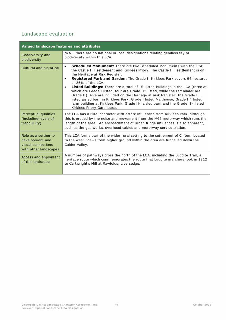
Calderdale District Landscape Character Assessment and
Review of Special Landscape Area Designation
40 October 2016
Landscape evaluation
Valued landscape features and attributes
Geodiversity and
biodiversity
N/A – there are no national or local designations relating geodiversity or
biodiversity within this LCA.
Cultural and historical Scheduled Monument: There are two Scheduled Monuments with the LCA;
the Castle Hill settlement and Kirklees Priory. The Castle Hill settlement is on the Heritage at Risk Register.
Registered Park and Garden: The Grade II Kirklees Park covers 64 hectares
or 26% of the LCA. Listed Buildings: There are a total of 15 Listed Buildings in the LCA (three of
which are Grade I listed, four are Grade II* listed, while the remainder are Grade II). Five are included on the Heritage at Risk Register; the Grade I listed aisled barn in Kirklees Park, Grade I listed Malthouse, Grade II* listed farm building at Kirklees Park, Grade II* aisled barn and the Grade II* listed Kirklees Priory Gatehouse.
Perceptual qualities
(including levels of
tranquillity)
The LCA has a rural character with estate influences from Kirklees Park, although
this is eroded by the noise and movement from the M62 motorway which runs the
length of the area. An encroachment of urban fringe influences is also apparent,
such as the gas works, overhead cables and motorway service station.
Role as a setting to
development and
visual connections
with other landscapes
This LCA forms part of the wider rural setting to the settlement of Clifton, located
to the west. Views from higher ground within the area are funnelled down the
Calder Valley.
Access and enjoyment
of the landscape
A number of pathways cross the north of the LCA, including the Luddite Trail, a heritage route which commemorates the route that Luddite marchers took in 1812 to Cartwright’s Mill at Rawfolds, Liversedge.

Calderdale District Landscape Character Assessment and
Review of Special Landscape Area Designation
41 October 2016
LCA F2: Calder (Walsden, Todmorden, Hebden
Bridge, Mytholmroyd)
Location Map
Representative photographs
View across the valley from Westfield Gate The Rochdale Canal near Millwood
This LCA consists of the main valley of the River Calder, running the breadth of Calderdale District from
Todmorden in the west to Sowerby Bridge in the east. The Rochdale Canal runs parallel to the Calder,
and Hebble Brook flows through Halifax. The character area is wholly contained within the district.
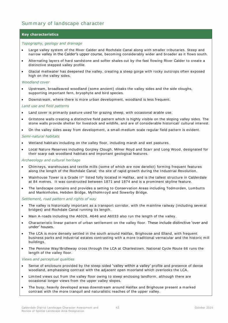
Calderdale District Landscape Character Assessment and
Review of Special Landscape Area Designation
42 October 2016
Summary of landscape character
Key characteristics
Topography, geology and drainage
Large valley system of the River Calder and Rochdale Canal along with smaller tributaries. Steep and narrow valley in the Calder’s upper course, becoming considerably wider and broader as it flows south.
Alternating layers of hard sandstone and softer shales cut by the fast flowing River Calder to create a
distinctive stepped valley profile.
Glacial meltwater has deepened the valley, creating a steep gorge with rocky outcrops often exposed
high on the valley sides.
Woodland cover
Upstream, broadleaved woodland (some ancient) cloaks the valley sides and the side cloughs,
supporting important fern, bryophyte and bird species.
Downstream, where there is more urban development, woodland is less frequent.
Land use and field patterns
Land cover is primarily pasture used for grazing sheep, with occasional arable use.
Gritstone walls creating a distinctive field pattern which is highly visible on the sloping valley sides. The stone walls provide shelter for livestock and wildlife, and are of considerable historical/ cultural interest.
On the valley sides away from development, a small-medium scale regular field pattern is evident.
Semi-natural habitats
Wetland habitats including on the valley floor, including marsh and wet pastures.
Local Nature Reserves including Gorpley Clough, Milner Royd and Scarr and Long Wood, designated for
their scarp oak woodland habitats and important geological features.
Archaeology and cultural heritage
Chimneys, warehouses and textile mills (some of which are now derelict) forming frequent features
along the length of the Rochdale Canal; the site of rapid growth during the Industrial Revolution.
Wainhouse Tower is a Grade II* listed folly located in Halifax, and is the tallest structure in Calderdale
at 84 metres. It was constructed between 1871 and 1874 and is a prominent skyline feature.
The landscape contains and provides a setting to Conservation Areas including Todmorden, Lumbutts and Mankinholes, Hebden Bridge, Mytholmroyd and Sowerby Bridge.
Settlement, road pattern and rights of way
The valley is historically important as a transport corridor, with the mainline railway (including several bridges) and Rochdale Canal running its length.
Main A-roads including the A6026, A646 and A6033 also run the length of the valley.
Characteristic linear pattern of urban settlement on the valley floor. These include distinctive ‘over and under’ houses.
The LCA is more densely settled in the south around Halifax, Brighouse and Elland, with frequent
business parks and industrial estates contrasting with a more traditional vernacular and the historic mill buildings.
The Pennine Way/Bridleway cross through the LCA at Charlestown. National Cycle Route 66 runs the
length of the valley floor.
Views and perceptual qualities
Sense of enclosure provided by the steep-sided ‘valley within a valley’ profile and presence of dense
woodland, emphasising contrast with the adjacent open moorland which overlooks the LCA.
Limited views out from the valley floor owing to steep enclosing landform, although there are
occasional longer views from the upper valley slopes.
The busy, heavily developed areas downstream around Halifax and Brighouse present a marked contrast with the more tranquil and naturalistic reaches of the upper valley.
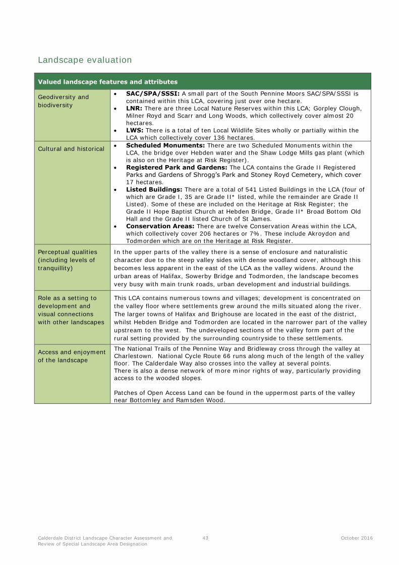
Calderdale District Landscape Character Assessment and
Review of Special Landscape Area Designation
43 October 2016
Landscape evaluation
Valued landscape features and attributes
Geodiversity and
biodiversity
SAC/SPA/SSSI: A small part of the South Pennine Moors SAC/SPA/SSSI is
contained within this LCA, covering just over one hectare. LNR: There are three Local Nature Reserves within this LCA; Gorpley Clough,
Milner Royd and Scarr and Long Woods, which collectively cover almost 20 hectares.
LWS: There is a total of ten Local Wildlife Sites wholly or partially within the LCA which collectively cover 136 hectares.
Cultural and historical Scheduled Monuments: There are two Scheduled Monuments within the
LCA, the bridge over Hebden water and the Shaw Lodge Mills gas plant (which
is also on the Heritage at Risk Register). Registered Park and Gardens: The LCA contains the Grade II Registered
Parks and Gardens of Shrogg’s Park and Stoney Royd Cemetery, which cover 17 hectares.
Listed Buildings: There are a total of 541 Listed Buildings in the LCA (four of which are Grade I, 35 are Grade II* listed, while the remainder are Grade II Listed). Some of these are included on the Heritage at Risk Register; the Grade II Hope Baptist Church at Hebden Bridge, Grade II* Broad Bottom Old Hall and the Grade II listed Church of St James.
Conservation Areas: There are twelve Conservation Areas within the LCA,
which collectively cover 206 hectares or 7%. These include Akroydon and Todmorden which are on the Heritage at Risk Register.
Perceptual qualities
(including levels of
tranquillity)
In the upper parts of the valley there is a sense of enclosure and naturalistic
character due to the steep valley sides with dense woodland cover, although this
becomes less apparent in the east of the LCA as the valley widens. Around the
urban areas of Halifax, Sowerby Bridge and Todmorden, the landscape becomes
very busy with main trunk roads, urban development and industrial buildings.
Role as a setting to
development and
visual connections
with other landscapes
This LCA contains numerous towns and villages; development is concentrated on
the valley floor where settlements grew around the mills situated along the river.
The larger towns of Halifax and Brighouse are located in the east of the district,
whilst Hebden Bridge and Todmorden are located in the narrower part of the valley
upstream to the west. The undeveloped sections of the valley form part of the
rural setting provided by the surrounding countryside to these settlements.
Access and enjoyment
of the landscape
The National Trails of the Pennine Way and Bridleway cross through the valley at Charlestown. National Cycle Route 66 runs along much of the length of the valley floor. The Calderdale Way also crosses into the valley at several points.
There is also a dense network of more minor rights of way, particularly providing access to the wooded slopes.
Patches of Open Access Land can be found in the uppermost parts of the valley near Bottomley and Ramsden Wood.
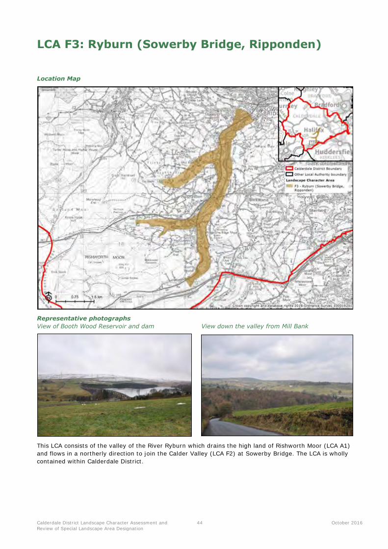
Calderdale District Landscape Character Assessment and
Review of Special Landscape Area Designation
44 October 2016
LCA F3: Ryburn (Sowerby Bridge, Ripponden)
Location Map
Representative photographs
View of Booth Wood Reservoir and dam View down the valley from Mill Bank
This LCA consists of the valley of the River Ryburn which drains the high land of Rishworth Moor (LCA A1)
and flows in a northerly direction to join the Calder Valley (LCA F2) at Sowerby Bridge. The LCA is wholly
contained within Calderdale District.
Calderdale District Landscape Character Assessment and
Review of Special Landscape Area Designation
45 October 2016
Summary of landscape character
Key characteristics
Topography, geology and drainage
Forked valley system associated with the River Ryburn. The valley is steep and narrow, with steps,
terraces and deep side cloughs reflecting the underlying Millstone Grit geology and past weathering
processes.
Ryburn Reservoir located in the westernmost part of the LCA, fed by water from the nearby upland of
Rishworth Moor.
Booth Wood Reservoir is also located adjacent to the LCA, its dam forming a large, prominent structure
visible from much of the valley.
Woodland cover
Broadleaved woodland (including some of ancient origin) is located on the valley sides and in the side
cloughs supporting important fern, bryophyte and bird species.
A rural character is afforded by avenues of beech trees which line the main road corridor.
Land use and field patterns
Small-scale, regular fields which are mostly under pastoral use are found on the valley sides.
Fields mainly enclosed by gritstone walls, these boundaries being of significant biodiversity, historic and
cultural importance within the landscape.
Semi-natural habitats
Thick broadleaved woodland with densely vegetated understorey providing an important resource for a
number of bird species.
In the south of the LCA, Turner Wood is locally designated as a Site of Ecological Interest.
Occasional valued valley-floor wetland habitats including fens and wet pastures.
Archaeology and cultural heritage
Wealth of historical and archaeological interest, reflecting the historic evolution of the area. This
includes numerous mills and weirs associated with the textile industry.
The LCA contains and provides a setting to the Ripponden and Millbank and Cottonstones Conservation
Areas.
Settlement, road pattern and rights of way
Characteristic linear pattern of urban settlement on the valley floor including the communities of
Ripponden, Rishworth and Beechwood.
The A58 runs along the western side of the main valley of the River Ryburn. Roads providing access up
the valley sides tend to be minor and rural in character.
A now dismantled railway line is also found on the valley floor, another industrial relic.
The Calderdale Way circular route crosses through the LCA, along with a network of footpaths and
bridleways.
Views and perceptual qualities
Upstream, a sense of enclosure and naturalistic qualities is provided by the steep-sided valley profile
and presence of woodland, emphasising contrast with the open moorlands (LCA D2 and A1) above
which overlook the valley.
Near the River Calder (LCA F2), there are increasing urban influences of mills/factories, dense urban
development and pylon lines.
Calderdale District Landscape Character Assessment and
Review of Special Landscape Area Designation
46 October 2016
Landscape evaluation
Valued landscape features and attributes
Geodiversity and
biodiversity
LWS: There is a total of two Local Wildlife Sites within the LCA which
collectively cover 41 hectares or 7%. These are both woodland sites.
Cultural and historical Scheduled Monument: There is one Scheduled Monument within the LCA at
Ripponden Bridge. Listed Buildings: There are a total of 83 Listed Buildings in the LCA (three of
which are Grade II* listed, while the remainder are Grade II).
Conservation Areas: There are two Conservation Areas located at Ripponden and Millbank and Cottonstones.
Perceptual qualities
(including levels of
tranquillity)
The perceptual qualities of the valley vary greatly and are generally dependant on
the proximity to urban development. In the north of the valley, close to Sowerby
Bridge, urbanising influences detract from tranquillity. On the heavily wooded
eastern side of the valley, near to the settlement of Mill Bank, and the heads of
the valleys at Booth Dean Clough and River Ryburn the landscape is much more
undeveloped, naturalistic and tranquil.
Role as a setting to
development and
visual connections
with other landscapes
This LCA forms an immediate setting to numerous settlements contained within
the valley, including Ripponden, Triangle, Beechwood and Mill Bank.
Views out are generally limited by the steep slopes and dense woodland, although
there may be funnelled views down the valley from higher ground.
Access and enjoyment
of the landscape
There is a good network of footpaths and bridleways providing access to the
landscape, particularly to the woodlands and around the reservoirs. The Calderdale Way crosses through the LCA at Ripponden.
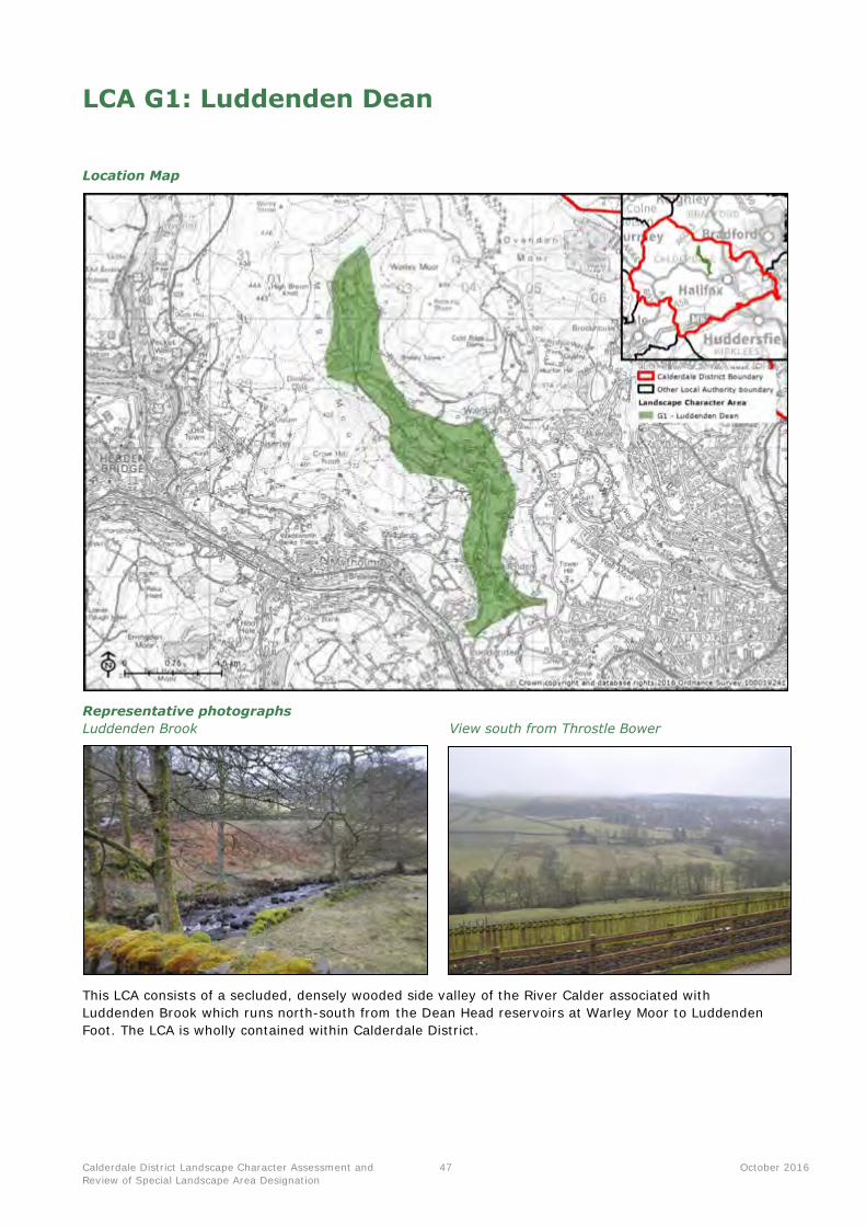
Calderdale District Landscape Character Assessment and
Review of Special Landscape Area Designation
47 October 2016
LCA G1: Luddenden Dean
Location Map
Representative photographs
Luddenden Brook View south from Throstle Bower
This LCA consists of a secluded, densely wooded side valley of the River Calder associated with
Luddenden Brook which runs north-south from the Dean Head reservoirs at Warley Moor to Luddenden
Foot. The LCA is wholly contained within Calderdale District.
Calderdale District Landscape Character Assessment and
Review of Special Landscape Area Designation
48 October 2016
Summary of landscape character
Key characteristics
Topography, geology and drainage
A distinctive incised landform with stepped terraces and the narrow valley floor of Luddenden Brook,
which flows into the River Calder near Luddenden Foot.
In the north of the LCA, the brook passes through the Upper Dean Head and Lower Dean Head
Reservoirs.
Fast flowing, moss and fern edged, streams cut down into the Millstone Grit bedrock. Springs feeding
into the streams are a frequent feature.
Woodland cover
Thick broadleaved woodland comprising beech, birch and oak cloaking the valley sides and following the main course of Luddenden Brook.
Mixed broadleaved and coniferous woodland is associated with the higher ground next to the reservoirs.
Mature trees are an occasional feature along field boundaries.
Land use and field patterns
In the north of the LCA, the primary land use is pasture for sheep grazing, arranged into small to medium scale, regular fields bounded by a mixture of gritstone walls and post and wire fencing.
Towards Luddenden, fields become larger and interspersed with occasional arable fields.
There are also some smallholdings, with horses and pigs being kept.
Semi-natural habitats
A mosaic of wetland habitats including freshwater streams, rush pasture, marsh and millponds on the valley floor.
Jerusalem Farm Local Nature Reserve is recognised for its ancient woodland and stream habitats.
Fragmented moorland habitats on the valley slopes, with gorse and bracken becoming more common at
higher elevations. A small part in the north falls within the South Pennines SPA, SAC, and SSSI.
Archaeology and cultural heritage
Strings of now derelict water-powered mills with associated features including mill ponds and races
occurring along the valley floor, reflecting early industrialisation.
The chimney at Oat’s Road Mill (now converted to apartments) is a prominent local landmark.
The landscape provides a sense of containment and setting to Luddenden Conservation Area.
Settlement, road pattern and rights of way
Settlement is sparse, mainly comprising isolated farms and dwellings often of a stone built vernacular.
The south of the LCA around Luddenden contains a higher density of built development.
Roads are often narrow and winding, with many dead ends.
Views and perceptual qualities
A secluded, ‘hidden’ and intimate character created by the incised landform, densely wooded slopes and overall absence of modern development
Patchwork of light and shade created by the juxtaposition of woodland and pastures.
The valley is overlooked by the moorland summits of Warley Moor and Midgeley Moor.
From the upper slopes, there are long views across the district although these are contained by the
surrounding moorland (LCA A1).
Calderdale District Landscape Character Assessment and
Review of Special Landscape Area Designation
49 October 2016
Landscape evaluation
Valued landscape features and attributes
Geodiversity and
biodiversity
SAC/SPA/SSSI: The South Pennine Moors SAC/SPA/SSSI covers 24 hectares
(5% of the LCA). LNR: There is one Local Nature Reserve partially within this LCA; Shibden Park
and Cunnery Wood (28.5 hectares within this LCA), which also crosses into LCA K1.
LWS: There are two Local Wildlife Sites wholly or partially within the LCA; Jerusalem Farm and Lower Height Farm, which collectively cover 21.8
hectares.
Cultural and historical Listed Buildings: There are a total of 45 Listed Buildings in the LCA (all of
which are Grade II listed). Conservation Areas: There is one Conservation Area located at Luddenden.
Perceptual qualities
(including levels of
tranquillity)
The wooded areas on the valley bottom of Luddenden Brook often feel intimate
and tranquil. On the upper valley slopes, particularly to the north, the landscape
feels more remote and inaccessible with narrow, steep roads which are often dead
ends.
Role as a setting to
development and
visual connections
with other landscapes
The valley provides an immediate rural setting and backdrop to the settlement of
Luddenden (which includes a Conservation Area), Luddenden Foot and Wainstalls.
Views from the valley floor are limited by the landform although can be more
extensive form the upper valley sides where there is a transition of character to
the surrounding upland fringes.
Access and enjoyment
of the landscape
The valley is serviced by a strong network of footpaths and bridleways providing access to the woodlands and steep valleys. The Calderdale Way crosses through the LCA at Jerusalem Farm Local Nature Reserve. A small patch of Open Access Land can be found at Dry Carr on the upper valley slopes.
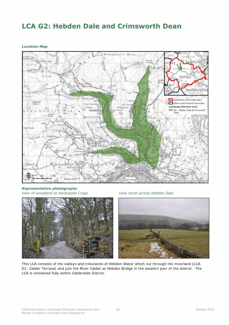
Calderdale District Landscape Character Assessment and
Review of Special Landscape Area Designation
50 October 2016
LCA G2: Hebden Dale and Crimsworth Dean
Location Map
Representative photographs
View of woodland at Hardcastle Crags View north across Hebden Dale
This LCA consists of the valleys and tributaries of Hebden Water which cut through the moorland (LCA
D1: Calder Terrace) and join the River Calder at Hebden Bridge in the western part of the district. The
LCA is contained fully within Calderdale District.
Calderdale District Landscape Character Assessment and
Review of Special Landscape Area Designation
51 October 2016
Summary of landscape character
Key characteristics
Topography, geology and drainage
Forked valley system of Crimsworth Dean Beck, Hebden Water, Hardcastle Crags and Colden Clough,
collectively flowing into the River Calder at Hebden Bridge.
Distinctive incised landform with stepped terraces and narrow valley floors. Exposed rock and crags can be seen along the top of the valley.
Fast flowing, moss and fern edged, streams cut down into the underlying Millstone Grit bedrock. There
are several waterfalls including Lumb Holl Waterfall.
Woodland cover
Thick broadleaved woodland including ancient upland oak woodland of high nature conservation value,
clothing the valley sides. Sites include Eaves Wood, Spring Wood and Hebden Wood.
Woodland at the National Trust site of Hardcastle Crags was planted in the 1870s and is comprised of
beech, sycamore, Scots pine and oak.
Land use and field patterns
Small-scale, mainly regular fields found along the valley sides. These are enclosed by gritstone walls.
Predominantly pastoral land use, with occasional arable fields.
Much of the land within the valleys is owned and managed by the National Trust, providing a valued recreational resource to local communities.
Semi-natural habitats
Much of the woodland and valley floor is locally designated for its ecological value, including Colden Clough Local Nature Reserve and Hardcastle Crags Site of Ecological Interest.
A mosaic of wetland habitats including freshwater streams, wet meadows, marsh and millponds on the
valley floor.
Archaeology and cultural heritage
Weirs and mills are a frequent feature along the watercourses, indicating the past industrial importance
of this area, particularly in the textile industry. This includes Gibson Mill, a former cotton mill which is now a visitor and education centre owned by the National Trust.
The Old Church of St Thomas Becket is located in Heptonstall and is designated as a Scheduled
Monument and Grade II* Listed Building.
The LCA contains parts of and contributes to the setting of the Hebden Bridge and Heptonstall
Conservation Areas.
Settlement, road pattern and rights of way
In the upper reaches of the valleys, settlement is sparse and consists of isolated farm buildings and
houses. Settlement is concentrated around Hebden Bridge and Heptonstall (with its distinctive cobbled
streets) in the south of the LCA.
Roads are sparse and generally very minor in the upper valleys. The A6033 runs from the north of
Hebden Bridge towards Oxenhope (Bradford metropolitan borough).
The Calderdale Way circular route crosses through the southern part of the LCA, while numerous footpaths and rights of way provide access to the upper parts of the dales and cloughs. Part of an
ancient packhorse route is also located in this LCA.
Views and perceptual qualities
A secluded, ‘hidden’ intimate and tranquil character created by the incised landform, densely wooded
slopes and overall absence of modern development.
Within the valleys, the sound of flowing water and bird song creates a naturalistic, tranquil feeling.
Generally visually enclosed due to the enclosed valley profile and dense tree cover, although is
overlooked by rounded hill summits of the adjacent upland fringes including Turn Hill.
Calderdale District Landscape Character Assessment and
Review of Special Landscape Area Designation
52 October 2016
Landscape evaluation
Valued landscape features and attributes
Geodiversity and
biodiversity
SAC/SPA: The South Pennine Moors SAC/SPA covers a total of 4.7 hectares.
SSSI: There are two SSSIs within this LCA; Crimsworth Dean and the South Pennine Moors. These collectively cover a total of 7.9 hectares.
LNR: There is one Local Nature Reserve partially within this LCA; Colden Clough (31.6 hectares within this LCA), which also crosses into LCAs D1 and F2.
LWS: There are two Local Wildlife Sites within the LCA; Colden Clough and
Hardcastle Crags. These cover 276.3 hectares or 37.1% of the LCA. LGS: There are three Local Geological Sites within the LCA; Colden Clough,
Hell Hole Quarry, and Lumb Falls. These collectively cover 12.1 hectares.
Cultural and historical Scheduled Monument: There is one Scheduled Monument within this LCA;
the Old Church of St Thomas Becket. Listed Buildings: There are a total of 22 Listed Buildings in the LCA (four of
which are Grade II* listed, while the remainder are Grade II). One of these is included on the Heritage at Risk Register - the Grade II* listed Church of St Thomas Becket.
Conservation Areas: There are two Conservation Areas located within Hebden Bridge and Heptonstall.
Perceptual qualities
(including levels of
tranquillity)
In the upper reaches of the valleys, the LCA is highly peaceful and tranquil, with a
naturalistic feel afforded by the dense woodland, and the sound of flowing water
and birdsong. Closer to Hebden Bridge, these perceptual qualities can be eroded
owing to increased human activity and development.
Role as a setting to
development and
visual connections
with other landscapes
This LCA forms an attractive wooded backdrop to the town of Hebden Bridge,
which also includes a Conservation Area. It also provides an important part of the
setting to the distinctive cobbled village of Heptonstall, with its Conservation Area.
Views out from the valley are mostly restricted by the landform and trees.
Access and enjoyment
of the landscape
Much of the LCA is owned/managed by the National Trust and is a popular
destination for recreation, with many footpaths providing access to the woodland and destinations such as Gibson Mill and Hardcastle Crags. The numerous waterfalls are also popular with visitors. The Calderdale Way passes through the valley at New Bridge.
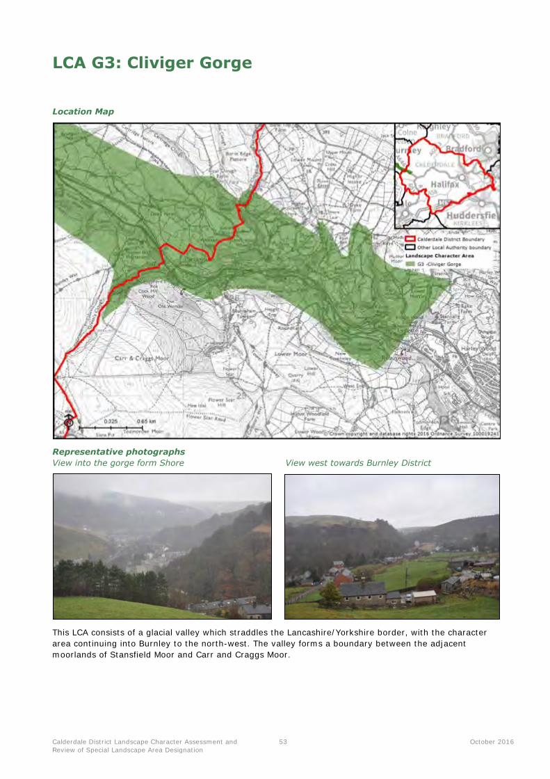
Calderdale District Landscape Character Assessment and
Review of Special Landscape Area Designation
53 October 2016
LCA G3: Cliviger Gorge
Location Map
Representative photographs
View into the gorge form Shore View west towards Burnley District
This LCA consists of a glacial valley which straddles the Lancashire/Yorkshire border, with the character
area continuing into Burnley to the north-west. The valley forms a boundary between the adjacent
moorlands of Stansfield Moor and Carr and Craggs Moor.
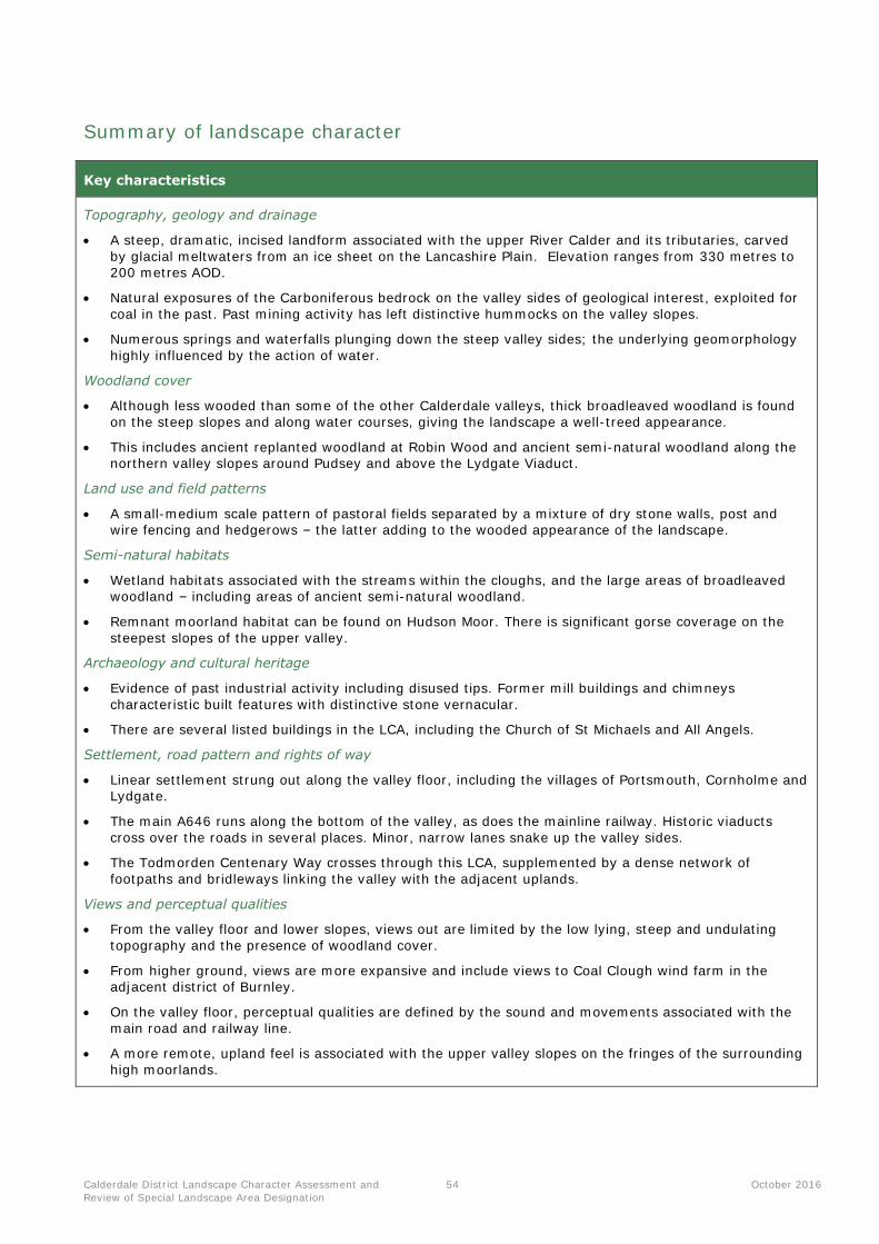
Calderdale District Landscape Character Assessment and
Review of Special Landscape Area Designation
54 October 2016
Summary of landscape character
Key characteristics
Topography, geology and drainage
A steep, dramatic, incised landform associated with the upper River Calder and its tributaries, carved
by glacial meltwaters from an ice sheet on the Lancashire Plain. Elevation ranges from 330 metres to 200 metres AOD.
Natural exposures of the Carboniferous bedrock on the valley sides of geological interest, exploited for
coal in the past. Past mining activity has left distinctive hummocks on the valley slopes.
Numerous springs and waterfalls plunging down the steep valley sides; the underlying geomorphology
highly influenced by the action of water.
Woodland cover
Although less wooded than some of the other Calderdale valleys, thick broadleaved woodland is found
on the steep slopes and along water courses, giving the landscape a well-treed appearance.
This includes ancient replanted woodland at Robin Wood and ancient semi-natural woodland along the northern valley slopes around Pudsey and above the Lydgate Viaduct.
Land use and field patterns
A small-medium scale pattern of pastoral fields separated by a mixture of dry stone walls, post and wire fencing and hedgerows – the latter adding to the wooded appearance of the landscape.
Semi-natural habitats
Wetland habitats associated with the streams within the cloughs, and the large areas of broadleaved woodland – including areas of ancient semi-natural woodland.
Remnant moorland habitat can be found on Hudson Moor. There is significant gorse coverage on the
steepest slopes of the upper valley.
Archaeology and cultural heritage
Evidence of past industrial activity including disused tips. Former mill buildings and chimneys
characteristic built features with distinctive stone vernacular.
There are several listed buildings in the LCA, including the Church of St Michaels and All Angels.
Settlement, road pattern and rights of way
Linear settlement strung out along the valley floor, including the villages of Portsmouth, Cornholme and Lydgate.
The main A646 runs along the bottom of the valley, as does the mainline railway. Historic viaducts
cross over the roads in several places. Minor, narrow lanes snake up the valley sides.
The Todmorden Centenary Way crosses through this LCA, supplemented by a dense network of
footpaths and bridleways linking the valley with the adjacent uplands.
Views and perceptual qualities
From the valley floor and lower slopes, views out are limited by the low lying, steep and undulating
topography and the presence of woodland cover.
From higher ground, views are more expansive and include views to Coal Clough wind farm in the adjacent district of Burnley.
On the valley floor, perceptual qualities are defined by the sound and movements associated with the
main road and railway line.
A more remote, upland feel is associated with the upper valley slopes on the fringes of the surrounding
high moorlands.
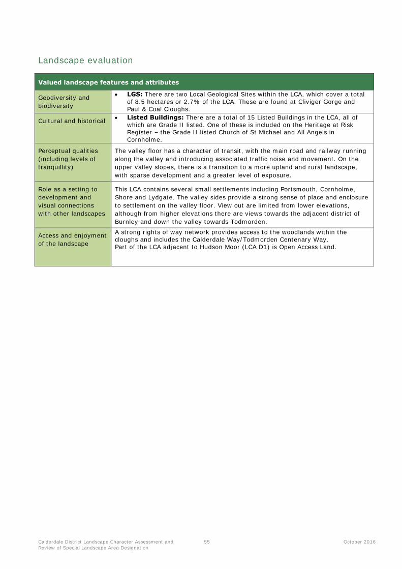
Calderdale District Landscape Character Assessment and
Review of Special Landscape Area Designation
55 October 2016
Landscape evaluation
Valued landscape features and attributes
Geodiversity and
biodiversity
LGS: There are two Local Geological Sites within the LCA, which cover a total
of 8.5 hectares or 2.7% of the LCA. These are found at Cliviger Gorge and Paul & Coal Cloughs.
Cultural and historical Listed Buildings: There are a total of 15 Listed Buildings in the LCA, all of
which are Grade II listed. One of these is included on the Heritage at Risk Register – the Grade II listed Church of St Michael and All Angels in Cornholme.
Perceptual qualities
(including levels of
tranquillity)
The valley floor has a character of transit, with the main road and railway running
along the valley and introducing associated traffic noise and movement. On the
upper valley slopes, there is a transition to a more upland and rural landscape,
with sparse development and a greater level of exposure.
Role as a setting to
development and
visual connections
with other landscapes
This LCA contains several small settlements including Portsmouth, Cornholme,
Shore and Lydgate. The valley sides provide a strong sense of place and enclosure
to settlement on the valley floor. View out are limited from lower elevations,
although from higher elevations there are views towards the adjacent district of
Burnley and down the valley towards Todmorden.
Access and enjoyment
of the landscape
A strong rights of way network provides access to the woodlands within the
cloughs and includes the Calderdale Way/Todmorden Centenary Way. Part of the LCA adjacent to Hudson Moor (LCA D1) is Open Access Land.
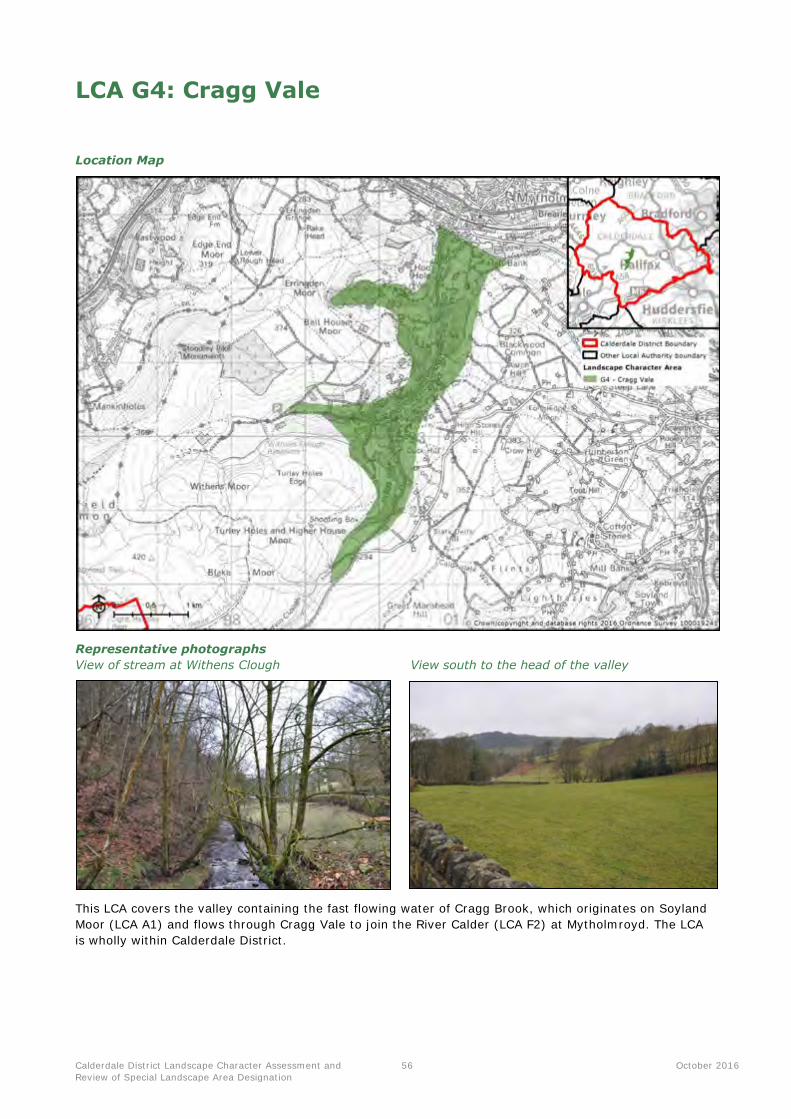
Calderdale District Landscape Character Assessment and
Review of Special Landscape Area Designation
56 October 2016
LCA G4: Cragg Vale
Location Map
Representative photographs
View of stream at Withens Clough View south to the head of the valley
This LCA covers the valley containing the fast flowing water of Cragg Brook, which originates on Soyland
Moor (LCA A1) and flows through Cragg Vale to join the River Calder (LCA F2) at Mytholmroyd. The LCA
is wholly within Calderdale District.
Calderdale District Landscape Character Assessment and
Review of Special Landscape Area Designation
57 October 2016
Summary of landscape character
Key characteristics
Topography, geology and drainage
Distinctive valley landform with steep slopes and a relatively wide floor, containing Cragg Brook and its tributaries.
Fast flowing stream of Cragg Brook, carving a steep valley through the underlying Millstone Grit. Springs and waterfalls are occasional features. Several weirs are located along the brook.
Woodland cover
Numerous areas of broadleaved woodland found along the valley sides, including Hove Yard Wood, Deacon Hill Wood, Whams Wood and Lord Wood. Much of this is ancient semi-natural woodland.
Occasional conifer plantations are located along the valley slopes.
Trees located along field boundaries are fairly common, especially in the north of the LCA.
Land use and field patterns
Small-scale fields along the valley sides, mostly enclosed by gritstone walls. The field pattern is generally regular, although there are some areas of irregularity where the landform is more complex.
Pasture is the primary land use within the LCA, although in the north of the area there are occasional fields of arable cropping.
Semi-natural habitats
Valued wetland habitats including freshwater streams and rush pastures.
Broadhead Clough is designated as a SSSI for its moorland, woodland and acid grassland habitats, including areas of heather.
Archaeology and cultural heritage
Historic mills and weirs along the valley floor providing evidence of the valley’s industrial heritage. An old chimney on the slopes of the Withens Clough in the west of the LCA is a prominent skyline feature.
The infamous Cragg Vale Coiners gang of counterfeiters originated and operated in this area in the 1760s. They produced fake gold coins to supplement small incomes from weaving.
The LCA contains part of and provides an attractive wooded setting to the Mytholmroyd Conservation Area.
Settlement, road pattern and rights of way
Stone built houses are found in a linear pattern along the main road. Elsewhere, settlement is sparse, consisting of isolated farms and dwellings. In the north of the LCA, the fringes of Mytholmroyd have an
influence on character.
The B6138 runs the length of the valley floor, with minor rural roads and tracks serving the farmhouses.
The Calderdale Way crosses through the LCA and is accompanied by a dense network of footpaths throughout the rest of the area.
Views and perceptual qualities
A rural, pastoral character is created by the patchwork of pasture and areas of woodland. The LCA feels enclosed due to the incised landform and densely wooded slopes. This quality is impacted in places by traffic noise and modern development, particularly in the north.
Immediately overlooked by Bell House Moor and Turley Holes Edge, forming naturalistic skylines crowned by woodland and open expanses of moorland.
There are channelled views up the valley to the north, with the wooded slopes of the Calder Valley (LCA F2) visible at the mouth of the valley.
The B6138 can become busy at peak times, detracting from the valley’s overall levels of tranquillity.

Calderdale District Landscape Character Assessment and
Review of Special Landscape Area Designation
58 October 2016
Landscape evaluation
Valued landscape features and attributes
Geodiversity and
biodiversity
SAC/SPA: A small part of the South Pennine Moors SAC/SPA falls within this
LCA, covering 4 hectares. SSSI: There are three SSSIs wholly or partially within this LCA; Broadhead
Clough, South Pennine Moors and Withins Clough, which collectively cover nearly 25 hectares.
Cultural and historical Listed Buildings: There are a total of 119 Listed Buildings in the LCA (four of
which are Grade II* listed, while the remainder are Grade II). Conservation Areas: There is one Conservation Area located within
Mytholmroyd.
Perceptual qualities
(including levels of
tranquillity)
Comparatively rural and tranquil especially compared to the heavily developed and
settled Calder Valley to the north (LCA F2). Levels of tranquillity are higher away
from the main road (B6138), especially in the Withens Clough valley to the west
with its dense woodland and sound of the flowing stream.
Role as a setting to
development and
visual connections
with other landscapes
Views are generally enclosed as a result of the steep slopes, although they can be
more extensive from the upper valley slopes, including glimpses of the uplands to
the north. The valley provides a direct rural setting to the settlements of Cragg
Vale and Mytholomroyd.
Access and enjoyment
of the landscape
A dense network of footpaths provides access to the woodland on the valley slopes, including The Calderdale Way, which crosses east-west through the LCA. Small patches of Open Access Land are found at the top of the valley adjacent to
the uplands.

Calderdale District Landscape Character Assessment and
Review of Special Landscape Area Designation
59 October 2016
LCA G12: Shibden Valley
Location Map
Representative photographs
View from Sutcliffe Wood Farm View south down the valley to the upland fringes
beyond
This LCA consists of one contiguous valley system, contained fully within Calderdale District. It is located
between the settlements of Halifax and Brighouse in the eastern half of the district, and ends where the
valley meets the River Calder to the south of the LCA.

Calderdale District Landscape Character Assessment and
Review of Special Landscape Area Designation
60 October 2016
Summary of landscape character
Key characteristics
Topography, geology and drainage
Narrow, steep sided valley system associated with Shibden Brook, Jum Hole Beck and Red Beck, which
flow to meet the River Calder to the south of the LCA.
Distinctive incised landform with stepped terraces and a narrow valley floor.
Local areas of landslip on the steep valley sides exposing important geological sites and creating
distinctive landform features. These include the locally important site of Wood Head Quarry, designated
as a Site of Geological Interest.
As well as the fast flowing brooks, numerous springs feed from the upper slopes. There are also several
ponds and two small lakes with the LCA - one within Shibden Park and another at Upper Lake.
Woodland cover
Valley sides clothed by thick broadleaved woodland, including ancient woodland of high nature
conservation value. Species include poplar, birch, beech and willow.
Land use and field patterns
Patchwork of pastoral and arable fields found along valley sides, arranged in a small scale, fairly regular
pattern. Field boundaries consist of gritstone walls and hedgerows.
Horse paddocks are a common land use on the fringes of settlements.
Semi-natural habitats
Shibden Park and Cunnery Wood Local Nature Reserve recognised for its parkland, woodland, grassland
and ponds which provide habitats for wildlife including birds, amphibians and invertebrates.
Archaeology and cultural heritage
The Magna Via Scheduled Monument is located to the west of Hipperholme, comprising the remains of
a medieval road travelling east from Halifax.
Shibden Hall is a Grade II Registered Park and Garden, which includes the Grade II* listed building of
Shibden Hall, built in 1420.
Settlement, road pattern and rights of way
Characteristic settlement pattern of white-washed and stone dwellings often found in a linear fashion
along roads.
Development on the edges of some nearby towns and villages beginning to encroach into the
landscape, for example around Brighouse, Hipperholme and Northowram.
Minor roads generally running along the length of the valley, becoming very steep and narrow on the
valley sides. The A58 and A6036 cross through the LCA linking Halifax and Northowram.
The Calderdale Way passes through the northern part of this LCA, accompanied by a dense network of
footpaths and bridleways throughout the area, including part of the Brighouse Boundary Walk.
Views and perceptual qualities
Views generally limited by the landform and woodland cover, although from higher slopes there are
occasional glimpses of the adjacent uplands to the north-west.
A secluded and tranquil character as a result of the incised landform, densely wooded slopes, streams
and overall absence of modern development. A line of pylons runs along the upper west valley side
which can detract from these qualities locally.
The south of the valley around Sutcliffe Wood is highly tranquil and naturalistic.
Calderdale District Landscape Character Assessment and
Review of Special Landscape Area Designation
61 October 2016
Landscape evaluation
Valued landscape features and attributes
Geodiversity and
biodiversity
LWS: There is one Local Wildlife Site in the LCA; Shibden Park and Cunnery
Wood, which covers 28.5 hectares or 4.6%. LGS: There is one Local Geological Site in the LCA at Wood Head Quarries,
which covers 1.9 hectares.
Cultural and historical Scheduled Monument: There is one Scheduled Monument in the LCA; The
Magna Via early road.
Registered Park and Garden: The Grade II Shibden Hall Park and Garden covers 24 hectares of the LCA.
Listed Buildings: There are a total of 15 Listed Buildings in the LCA (four of
which are Grade II* listed, while the remainder are Grade II). One of these is included on the Heritage at Risk Register - the Grade II* listed Scout Hall in Halifax.
Perceptual qualities
(including levels of
tranquillity)
Despite being close to urban development, the LCA is rural, tranquil and
naturalistic, particularly in the south of the valley near to Sutcliff Wood. There are
some urban fringe influences including pylon lines.
Role as a setting to
development and
visual connections
with other landscapes
Views out are generally enclosed by the landform and tree cover, although there
are longer views down the Calder Valley (LCA F2) from the higher slopes. The LCA
forms part of the backdrop and setting to Brighouse, Hipperholme and
Northowram.
Access and enjoyment
of the landscape
Numerous footpaths and bridleways offer access to and within the LCA, including
the Calderdale Way and Brighouse Boundary Walk. Shibden Park is also a valued destination for recreational activity.

Calderdale District Landscape Character Assessment and
Review of Special Landscape Area Designation
62 October 2016
LCA G13: Clifton Beck
Location Map
Representative photographs
View west from Middle Ox Heys Shelf Hall Park in the north of the LCA
This LCA consists of one contiguous valley in the east of Calderdale District. The Clifton Beck Valley is
located to the south of Shelf and runs down the eastern side of Brighouse. The LCA is fully contained
within Calderdale.
Calderdale District Landscape Character Assessment and
Review of Special Landscape Area Designation
63 October 2016
Summary of landscape character
Key characteristics
Topography, geology and drainage
Distinctive incised forked valley landform associated with several becks and brooks including Clifton
Beck, Hoyle House Beck, Bottom Hall Beck and Wyke Beck.
Fast flowing, moss and fern-edged streams cutting down into the underlying Pennine Coal Measures
bedrock.
Woodland cover
Thick broadleaved woodland including beech, sycamore and Scots pine cloaking the valley sides. Areas
of woodland include Sun Wood, North Wood and Jagger Park Wood. This includes areas of ancient
woodland in the north of the valley.
There is a significant area of broadleaved woodland located in Wellholme Park in the south of the LCA.
This includes oak, ash, sycamore and rowan.
In-field and boundary trees are frequent features, adding to the valley’s wooded character.
Land use and field patterns
Small-medium scale pasture fields arranged in a regular pattern along the valley sides, divided by a
mixture of gritstone walls and hedgerows.
Disused shafts provide evidence of the landscape’s industrial heritage.
Semi-natural habitats
Sun Wood, to the south of Shelf, is recognised as a locally important ecological site – comprising
ancient upland oak woodlands.
Freshwater streams on the valley floor provide semi-natural habitats for aquatic species.
Archaeology and cultural heritage
Strings of watermills with associated features including mill ponds, races and dismantled railways
located along the valley floor; legacies of the area’s industrial past.
Wellholme Park in the south of the LCA is recognised as a locally significant park and garden, as is
Shelf Hall Park in the north.
Settlement, road pattern and rights of way
The valley becomes densely settled in the south where it skirts around Brighouse. Settlement upstream
is sparser and consists of small villages and isolated farms.
In the north of the valley, roads are infrequent and minor. The A641 runs along the bottom of the
valley to the south of Bailiff Bridge.
The Bradford to Halifax railway crosses the valley via the Grade II listed Bottom Viaduct.
The Calderdale Way circular route crosses through much of the LCA, joined by the Brontë Way and the
Brighouse Boundary Walk, along with other footpaths, cycle routes and bridleways.
Views and perceptual qualities
A secluded, ‘hidden’ and tranquil character created by the incised landform, densely wooded slopes and
pockets free from modern development, particularly in the north.
There are limited views out as a result of the landform and tree cover.
To the south, there are some urban fringe influences, including pylon lines crossing to the north of
Norwood Green.
From the upper slopes, views are funnelled south to include the urban form of Brighouse and the
upland fringes beyond.

Calderdale District Landscape Character Assessment and
Review of Special Landscape Area Designation
64 October 2016
Landscape evaluation
Valued landscape features and attributes
Geodiversity and
biodiversity
LWS: There is one Local Wildlife Site within the LCA; Sun Wood, which covers
26.8 hectares or 6.6% of the LCA. LGS: There is one Local Geological Site within the LCA; Royds Hall Beck, which
covers 2.3 hectares.
Cultural and historical Listed Buildings: There are a total of 39 Listed Buildings in the LCA (all of
which are Grade II listed).
Perceptual qualities
(including levels of
tranquillity)
Comparatively rural and tranquil considering the proximity of adjacent urban
development, although this can be eroded by the presence of main roads and
industrial development, particularly in the south near Brighouse. The north of the
valley is highly tranquil due to low levels of development and dense woodland.
Role as a setting to
development and
visual connections
with other landscapes
This valley forms an immediate rural setting to several settlements, providing a
green edge to Brighouse, Lighthouse, Norwood Green and Shelf. Views out are
generally limited although can be more extensive from the upper slopes to include
Brighouse and the uplands beyond.
Access and enjoyment
of the landscape
There are several long distance rights of way which pass through the LCA, including the Calderdale Way, Brontë Way and Brighouse Boundary Walk. Shelf Hall Park and Wellholme Park both provide destinations for informal recreation and amenity for nearby local communities.
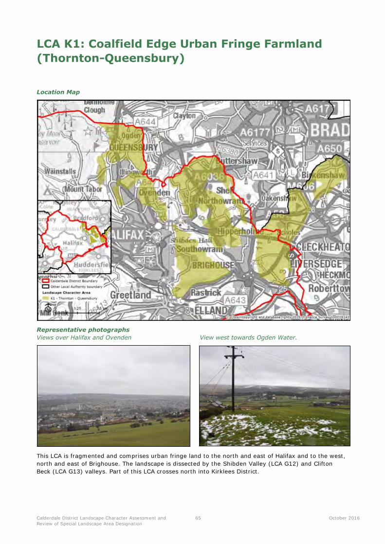
Calderdale District Landscape Character Assessment and
Review of Special Landscape Area Designation
65 October 2016
LCA K1: Coalfield Edge Urban Fringe Farmland
(Thornton-Queensbury)
Location Map
Representative photographs
Views over Halifax and Ovenden View west towards Ogden Water.
This LCA is fragmented and comprises urban fringe land to the north and east of Halifax and to the west,
north and east of Brighouse. The landscape is dissected by the Shibden Valley (LCA G12) and Clifton
Beck (LCA G13) valleys. Part of this LCA crosses north into Kirklees District.
Calderdale District Landscape Character Assessment and
Review of Special Landscape Area Designation
66 October 2016
Summary of landscape character
Key characteristics
Topography, geology and drainage
The LCA comprises pockets of higher gently undulating ground sloping up from the adjacent valleys of
Shibden Valley (LCA G12) and Clifton Beck (LCA G13).
Underlying geology of the Pennine Lower Coal Measures formation, comprising sandstones, shales and
mudstones with bands of coal.
Minor watercourses originating from springs on the higher ground flowing towards the surrounding
valleys, creating the rolling landform.
Woodland cover
Blocks of broadleaved woodland cloaking the slopes of stream valleys, including some ancient replanted
woodland at Jagger Park Wood.
Mature trees are a common feature along field boundaries, as are in-field trees.
Coniferous woodland around Ogden Water is a locally prominent feature.
Land use and field patterns
A mixed field pattern, ranging from larger-scale arable fields to small-scale pastoral enclosures which
results in a seasonal mosaic of colours and textures.
Horse paddocks and equestrian enterprises are common around settlements.
Field boundaries consisting of a mixture of stone walls, wire fences and hedgerows, with frequent trees.
Golf courses located on the fringes of settlements, including Crow Nest, Lightcliffe and Willow Valley
Golf Clubs.
Semi-natural habitats
Broadleaved riparian woodlands forming valued habitats, including Cromwell Wood and Elland Park
Wood (a Site of Ecological Interest). Remnant moorland habitat is found to the west of Swales Moor.
Beechwood Park Local Nature Reserve is located in the west of the LCA, recognised for its woodland
and grassland habitat.
Archaeology and cultural heritage
Numerous disused coal mining shafts and quarries alluding to the mining history of the area, including
a nationally important mine shaft, gin circle, spoil heap and tramway at Brow Pit, near Holmfield.
The LCA contains and provides a key part of the setting to Northowram Village Conservation Area.
Settlement and road pattern
Includes the settlements of Shelf, Northowram, Hipperholme, Clifton and Southowram which can
visually form a continuation of the surrounding urban areas.
Within the rural fringes, there are scattered farmsteads with buildings of a traditional local stone
vernacular. These are mixed in with more modern buildings of various styles.
Several A-roads crossing through the landscape, connecting the main towns. The M62 motorway skirts
round the eastern edge of the LCA close to Clifton.
Numerous trails crossing through the landscape, including the Calderdale Way, Brontë Way, Kirklees
Way and Brighouse Boundary Walk.
Views and perceptual qualities
Urban fringe character, due to the dense urban development adjacent to the LCA, including Halifax,
Brighouse and the outer Bradford suburbs.
Pylon lines and overhead cables often featuring in views, particularly around Southowram and Willow
Valley Golf Club.
Views vary due to the strongly undulating land, although are generally expansive due to elevation.
There are long views over Ovenden and Halifax to the uplands beyond in the west.
In clear conditions, travellers along the Keighley Road (A629) in the north of the LCA can enjoy
expansive views across the district, along the Calder and to the Peak District National Park beyond.

Calderdale District Landscape Character Assessment and
Review of Special Landscape Area Designation
67 October 2016
Landscape evaluation
Valued landscape features and attributes
Geodiversity and
biodiversity
SAC/SPA/SSSI: The South Pennine Moors SAC/SPA/SSSI covers a total of 11.4 hectares within the LCA.
LNR: There are three Local Nature Reserves; Beechwood Park, Ogden Water and Shibden Park and Cunnery Wood, which collectively cover 28.6 hectares.
LWS: There is a total of four Local Wildlife Sites wholly or partially within the LCA which collectively cover 71.1 hectares. The majority of these recognise
locally important woodland sites. LGS: There are two Local Geological Sites partially within the LCA; Beacon Hill
and Godley Cutting and Wood Head Quarry, which cover 1.6 hectares.
Cultural and historical Scheduled Monuments: There are three Scheduled Monuments within the
LCA; including the Magna Via ancient trackway and a ventilation
chimney/furnace house near Park Farm (also on the Heritage at Risk Register).
Listed Buildings: There are a total of 142 Listed Buildings in the LCA (one of which is Grade I listed, 11 of which are Grade II* listed, while the remainder are Grade II).
Conservation Areas: There is one Conservation Area located within Northowram Village which covers 17.4 hectares.
Perceptual qualities
(including levels of
tranquillity)
The LCA has an urban fringe character with a mixed land use and features such as
pylons, golf courses and modern development, although there are some more
rural and tranquil areas found further away from the main settlements which
surround the LCA. Strong visual connections with the district’s upland landscapes
evoke contrasting feelings of remoteness.
Tranquillity can be affected by traffic noise and movement relating to the main
roads which run through and adjacent to the LCA.
Role as a setting to
development and
visual connections
with other landscapes
This LCA contains and surrounds several settlements; located in the more densely
populated eastern part of the district around Halifax. These include Shelf,
Northowram, Hipperholme, Southowram and Mixenden. The LCA also surrounds
and rises up above the larger towns of Halifax and Brighouse, providing a rural
edge to development and visual connection with the upland landscapes to the
west.
In clear conditions, elevated land in the north of the LCA (including along the
Keighley Road) allows expansive views across the district, along the Calder and to
the Peak District National Park beyond.
Access and enjoyment
of the landscape
Many trails and footpaths provide access to the landscape, including the Kirklees Way, Calderdale Way and Brontë Way. A network of other routes links the villages with the surrounding woodland and countryside.
Small patches of Open Access Land are found at Scout Edge, Ringby Farm and near Beacon Hill.
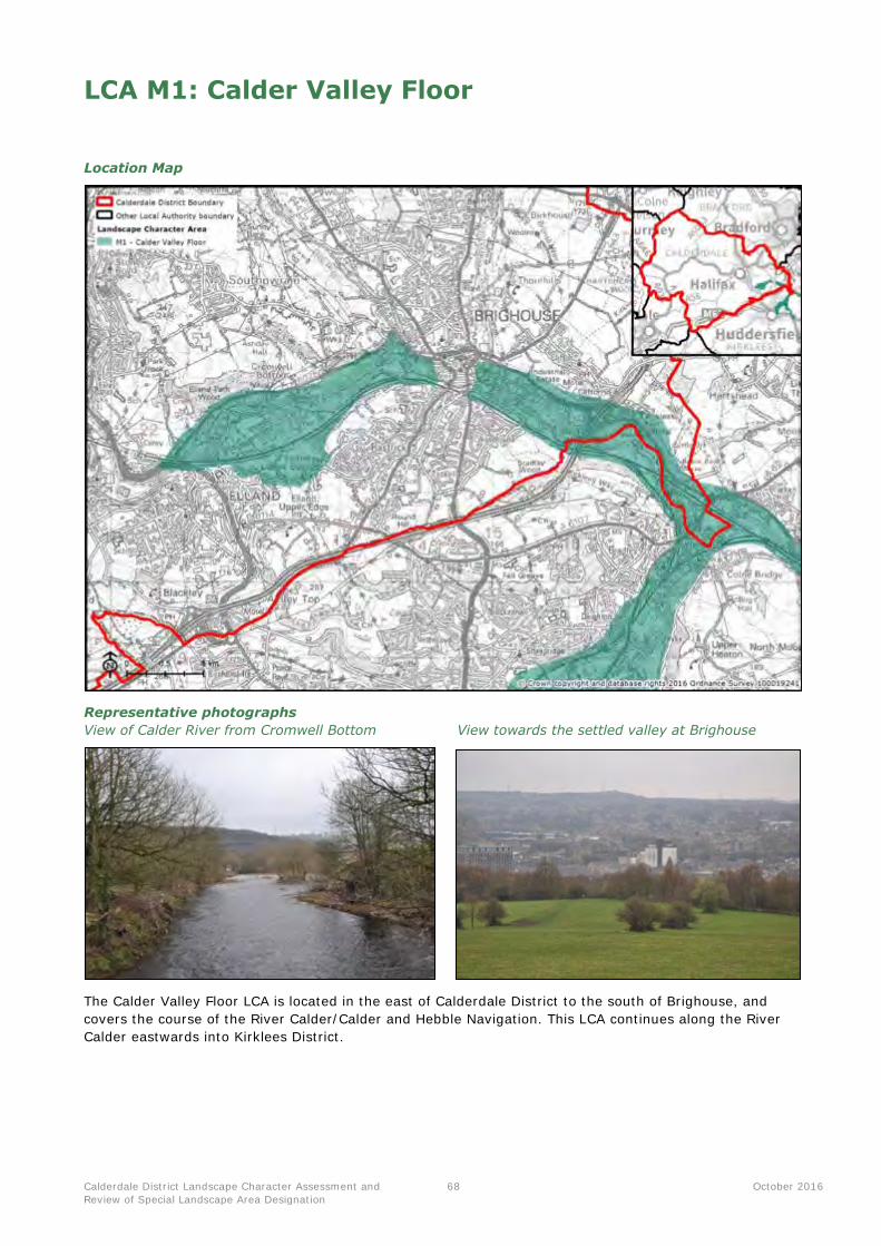
Calderdale District Landscape Character Assessment and
Review of Special Landscape Area Designation
68 October 2016
LCA M1: Calder Valley Floor
Location Map
Representative photographs
View of Calder River from Cromwell Bottom View towards the settled valley at Brighouse
The Calder Valley Floor LCA is located in the east of Calderdale District to the south of Brighouse, and
covers the course of the River Calder/Calder and Hebble Navigation. This LCA continues along the River
Calder eastwards into Kirklees District.
Calderdale District Landscape Character Assessment and
Review of Special Landscape Area Designation
69 October 2016
Summary of landscape character
Key characteristics
Topography, geology and drainage
Valley landscape drained by the River Calder and the Calder and Hebble Navigation.
Underlying geology of the Pennine Lower Coal Measures Formation, with some coal seams. This is overlain by alluvium deposits of clay, silt and sand deposited by the river during past flooding events.
Heavily modified drainage pattern, with numerous reservoirs, locks, weirs, dams and canalisation along the length of the main river.
Woodland cover
Woodland cover generally limited to the steep slopes of the valley as a result of extensive development and alterations to the rivers including the construction of the Calder and Hebble Navigation.
Small blocks of deciduous woodland generally restricted to the valley slopes. Lines of trees are found
along many of the waterways.
Trees are more abundant in the west of the LCA where birch and oak woodland is protected within the Cromwell Bottom Local Nature Reserve.
Land use and field patterns
Agricultural land cover is very limited due to urban development; only found in few locations including remnant pastures close to Brighouse.
In the west of the LCA there is a slate quarry with some accompanying (but now disused) shafts and tips.
Large industrial estates and works forming a dominant land use, in particular Lowfields Business Park
and Armytage Road Industrial Estate. The large, geometric forms of the buildings are prominent in views from the overlooking slopes.
Semi-natural habitats
Fragmented areas of broadleaved woodlands, wetland and meadow grassland providing valued habitats in an urban context.
Cromwell Bottom Nature Reserve is locally recognised for its bird life, hosting species including bullfinch, siskin and Greater spotted woodpeckers.
Archaeology and cultural heritage
A strong industrial heritage. Rivers and canals played a key part in the success of the textile industry in
this area, with mill buildings forming strongly recognisable features along the river and canal banks.
There are numerous Listed Buildings relating to the area’s industrial heritage and the historic waterway of the Calder and Hebble Navigation (constructed in the 18th century).
To the east, part of the landscaped grounds of the Grade II Registered Park and Garden of Kirklees Park are contained within the LCA.
Kirklees Park also contains the Scheduled Monument of Castle Hill, an Iron Age earthwork enclosure
located in a commanding position overlooking the valley.
Settlement and road pattern
Valley surrounded by dense urban development, particularly related to Brighouse and Elland, with large
industrial estates and warehouses occupying the valley floor.
Major railway lines also snake along the valley as well as main roads including the A6025 and A644.
Views and perceptual qualities
In the east of the LCA, the landscape is heavily urbanised and industrial with low levels of tranquillity. An exception is the woodland and gardens of Kirklees Park in the far east of the LCA.
In the west of the LCA, there is a more naturalistic feel in places, particularly Cromwell Bottom Nature Reserve, which forms an important naturalistic sanctuary on the edges of Brighouse and Rastrick.
Views generally enclosed as a result of the low lying topography, with land rising up either side of the valley.
Woodland at the top of the slopes forms naturalistic wooded skylines, although these are often negatively impacted upon by the presence of pylons and overhead cables.
From higher ground in the south of Cromwell Local Nature Reserve, there are channelled views down the valley.
Calderdale District Landscape Character Assessment and
Review of Special Landscape Area Designation
70 October 2016
Landscape evaluation
Valued landscape features and attributes
Geodiversity and
biodiversity
LNR: There is one Local Nature Reserve; Cromwell Bottom which covers a
total of 30 hectares (6.3% of LCA). LWS: There are five Local Wildlife sites in the LCA, which collectively cover
over 12% (58.3 hectares) of the LCA. LGS: There is one Local Geological Site at Strangstry Wood, which covers four
hectares.
Cultural and historical Scheduled Monuments: There is one Scheduled Monument located in
Kirklees Park; an Iron Age settlement at Castle Hill which covers just under one hectare. This site is also included on the Heritage at Risk Register.
Registered Park and Garden: Kirklees Park covers 23 hectares, or 4.8% of the LCA.
Listed Buildings: There are a total of 34 Listed Buildings in the LCA, all of which are Grade II listed.
Perceptual qualities
(including levels of
tranquillity)
The LCA generally has an industrial and urbanised character due to the presence
of numerous business parks, pylons, overhead cables, large trunk roads and the
immediate proximity of urban development. The semi-natural habitats at Cromwell
Bottom Local Nature Reserve form a tranquil, naturalistic oasis amongst the dense
development.
Role as a setting to
development and
visual connections
with other landscapes
This LCA contains parts of and forms an immediate part of the setting to
Brighouse, Rastrick and Elland. The woodland on the valley slopes provides a
naturalistic backdrop to the settlements, although pylons crossing the valley can
form detracting features. Views are generally contained within the valley.
Access and enjoyment
of the landscape
Cromwell Bottom Local Nature Reserve is valued as a destination for informal recreation, particularly for walkers and dog walkers from the nearby communities. The reserve includes 2 miles of wheelchair accessible paths.

Calderdale District Landscape Character Assessment and
Review of Special Landscape Area Designation
71 October 2016
Appendix 2 : SLA Statements of Significance
Contents
The SLA Statements of Value and Significance are presented in the following order:
SLA Parcel Number/Name Page number (click to link
through to the statement)
1: Northern Calderdale Moorlands and Fringes 72
2: Hardcastle Crags, Hebden Water and Colden Water 75
3: Luddenden Dean 78
4: Shibden Valley 81
5: Ringstone Edge and Norland Moor Fringes 84
6: Southern Calderdale Moorland and Fringes 87
7: Cragg Vale 90
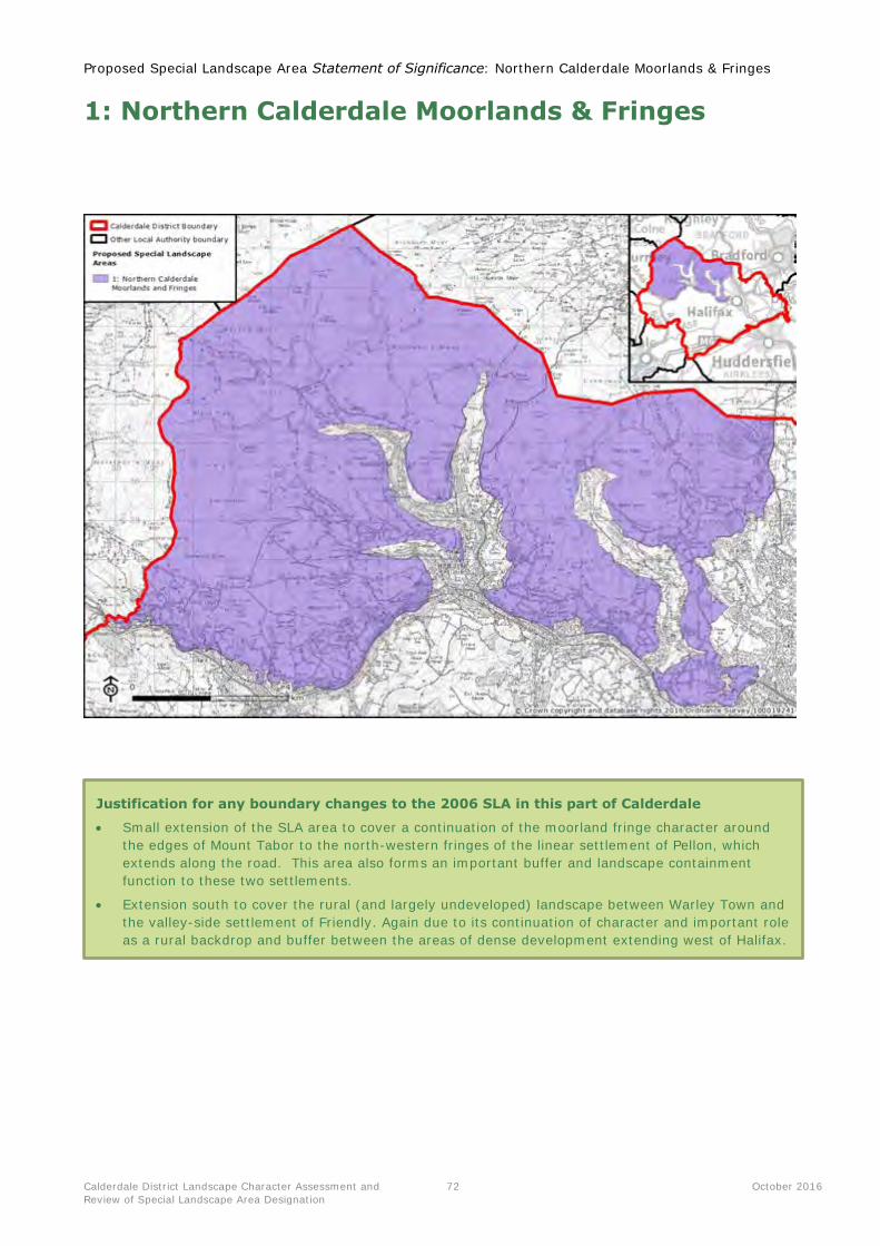
Proposed Special Landscape Area Statement of Significance: Northern Calderdale Moorlands & Fringes
Calderdale District Landscape Character Assessment and
Review of Special Landscape Area Designation
72 October 2016
1: Northern Calderdale Moorlands & Fringes
Justification for any boundary changes to the 2006 SLA in this part of Calderdale
Small extension of the SLA area to cover a continuation of the moorland fringe character around
the edges of Mount Tabor to the north-western fringes of the linear settlement of Pellon, which
extends along the road. This area also forms an important buffer and landscape containment
function to these two settlements.
Extension south to cover the rural (and largely undeveloped) landscape between Warley Town and
the valley-side settlement of Friendly. Again due to its continuation of character and important role
as a rural backdrop and buffer between the areas of dense development extending west of Halifax.
Proposed Special Landscape Area Statement of Significance: Northern Calderdale Moorlands & Fringes
Calderdale District Landscape Character Assessment and
Review of Special Landscape Area Designation
73 October 2016
Statement of Significance
Special Qualities of the Northern Calderdale Moorlands & Fringes
Series of elevated moors forming large scale sweeping plateaux, surrounded by a strong pattern of
upland pastures enclosed by gritstone walls.
Underlying Millstone Grit geology creating distinctive physical features such as frost weathered tors.
Incised by numerous small-scale stream valleys, cloughs and waterfalls.
Large parts within the South Pennine Moors SAC, SPA and SSSI, recognised for important heathland,
bogs and fens supporting rich upland breeding bird populations.
Species-rich hay meadows, rush pastures and wet woodlands providing further wildlife interest and
texture.
Strong sense of time depth with many Scheduled Monuments representing human interaction with
the landscape over millennia.
Dispersed settlement pattern fringing the moors, with scattered traditional stone farmsteads and
occasional historic villages.
A landscape providing artistic and literary inspiration throughout the centuries – famously associated
with the Brontës.
Strong perceptions of remoteness, isolation and wildness in contrast to the busy Calder valley.
Landscape forming a dramatic upland setting to valley settlements.
Expansive views owing to elevation – including south towards the Peak District National Park.
A series of open moorland plateaux and fringing upland pastures located in north-west Calderdale,
rising above the main Calder Valley. The landscape forms a distinctive upland backdrop to much of
the District, including the busy valley settlements of Todmorden, Hebden Bridge, Mytholmroyd and
Halifax. A perception of remoteness, isolation and wildness prevails on the moors, whilst a sense
of timelessness is associated with the sparsely settled upland pastures with strong gritstone
vernacular. The landscape forms part of the wider upland spine of the South Pennines, extending
from the Peak District to the south to the Yorkshire Dales to the north.
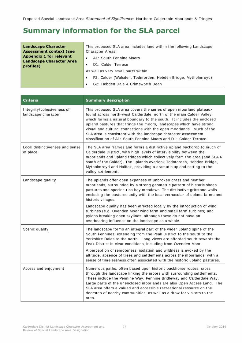
Proposed Special Landscape Area Statement of Significance: Northern Calderdale Moorlands & Fringes
Calderdale District Landscape Character Assessment and
Review of Special Landscape Area Designation
74 October 2016
Summary information for the SLA parcel
Landscape Character
Assessment context (see
Appendix 1 for relevant
Landscape Character Area
profiles)
This proposed SLA area includes land within the following Landscape
Character Areas:
A1: South Pennine Moors
D1: Calder Terrace
As well as very small parts within:
F2: Calder (Walsden, Todmorden, Hebden Bridge, Mytholmroyd)
G2: Hebden Dale & Crimsworth Dean
Criteria Summary description
Integrity/cohesiveness of
landscape character
This proposed SLA area covers the series of open moorland plateaux
found across north-west Calderdale, north of the main Calder Valley
which forms a natural boundary to the south. It includes the enclosed
upland pastures that fringe the moors, landscapes which have strong
visual and cultural connections with the open moorlands. Much of the
SLA area is consistent with the landscape character assessment
classification of A1: South Pennine Moors and D1: Calder Terrace.
Local distinctiveness and sense
of place
The SLA area frames and forms a distinctive upland backdrop to much of
Calderdale District, with high levels of intervisibility between the
moorlands and upland fringes which collectively form the area (and SLA 6
south of the Calder). The uplands overlook Todmorden, Hebden Bridge,
Mytholmroyd and Halifax, providing a dramatic upland setting to the
valley settlements.
Landscape quality The uplands offer open expanses of unbroken grass and heather
moorlands, surrounded by a strong geometric pattern of historic sheep
pastures and species-rich hay meadows. The distinctive gritstone walls
enclosing the pastures unify with the local vernacular of upland farms and
historic villages.
Landscape quality has been affected locally by the introduction of wind
turbines (e.g. Ovenden Moor wind farm and small farm turbines) and
pylons breaking open skylines, although these do not have an
overbearing influence on the landscape as a whole.
Scenic quality The landscape forms an integral part of the wider upland spine of the
South Pennines, extending from the Peak District to the south to the
Yorkshire Dales to the north. Long views are afforded south towards the
Peak District in clear conditions, including from Ovenden Moor.
A perception of remoteness, isolation and wildness is evoked by the
altitude, absence of trees and settlements across the moorlands, with a
sense of timelessness often associated with the historic upland pastures.
Access and enjoyment Numerous paths, often based upon historic packhorse routes, cross
through the landscape linking the moors with surrounding settlements.
These include the Pennine Way, Pennine Bridleway and Calderdale Way.
Large parts of the unenclosed moorlands are also Open Access Land. The
SLA area offers a valued and accessible recreational resource on the
doorstep of nearby communities, as well as a draw for visitors to the
area.

Proposed Special Landscape Area Statement of Significance: Hardcastle Crags, Hebden Water & Colden
Water
Calderdale District Landscape Character Assessment and
Review of Special Landscape Area Designation
75 October 2016
2: Hardcastle Crags, Hebden Water & Colden
Water
Justification for any boundary changes to the 2006 SLA in this part of Calderdale
No changes to SLA extent are proposed for this part of the District.
Proposed Special Landscape Area Statement of Significance: Hardcastle Crags, Hebden Water & Colden
Water
Calderdale District Landscape Character Assessment and
Review of Special Landscape Area Designation
76 October 2016
Statement of Significance
Special Qualities of Hardcastle Crags, Hebden Water & Colden Water
Distinctive incised landform with stepped terraces and narrow valley floors. Exposed rock and crags
visible along valley tops.
Fast flowing streams cutting through banks carpeted in moss and ferns, with several waterfalls.
Thick broadleaved woodland including ancient upland oak woodland of high nature conservation
value, as well as historic estate plantings at Hardcastle Crags.
Mosaic of wetland habitats including wet meadows, marsh and millponds.
Frequent weirs and mills indicating the past industrial importance of this area, particularly for water-
powered textile production.
Large parts owned and managed by the National Trust, providing a valued recreational resource to
local communities.
A secluded, ‘hidden’ and tranquil character created by the incised landform, densely wooded slopes and overall absence of modern development and main roads.
Distinctive forked valley system of Crimsworth Dean Beck, Hebden Water, Hardcastle Crags and
Colden Clough, collectively flowing south into the River Calder at Hebden Bridge. The incised
valley system creates a distinctive, contrasting enclosed landscape of fast-flowing streams cutting
through the surrounding uplands. Valley sides cloaked in woodland, ferns and mosses combine
with industrial heritage features to create a strong sense of place. The SLA parcel provides an
important rural setting to Hebden Bridge and Heptonstall Conservation Areas. The enclosed
landform, overall absence of development and semi-natural landcover create a strong sense of
seclusion and tranquillity.

Proposed Special Landscape Area Statement of Significance: Hardcastle Crags, Hebden Water & Colden
Water
Calderdale District Landscape Character Assessment and
Review of Special Landscape Area Designation
77 October 2016
Summary information for the SLA parcel
Landscape Character
Assessment context (see
Appendix 1 for relevant
Landscape Character Area
profiles)
This proposed SLA parcel includes land within the following Landscape
Character Area:
G2: Hebden Dale and Crimsworth Dean
As well as very small parts within:
D1: Calder Terrace
Criteria Summary description
Integrity/cohesiveness of
landscape character
This SLA parcel comprises the distinctive forked valley system of
Crimsworth Dean Beck, Hebden Water, Hardcastle Crags and Colden
Clough, collectively flowing south into the River Calder at Hebden Bridge.
The valleys cut through the surrounding upland pastures of the Calder
Terrace. The SLA parcel is consistent with the classification of Landscape
Character Area G2, pulling in some very small sections of the upper
wooded valley slopes above Hebden Dale from within D1: Calder Terrace.
Local distinctiveness and sense
of place
The incised valley system creates a distinctive, contrasting enclosed
landscape of fast-flowing streams cutting through the surrounding
uplands. Valley sides cloaked in woodland, ferns and mosses combine
with industrial heritage features to create a strong sense of place. The
SLA parcel forms an important rural setting to Hebden Bridge and
Heptonstall Conservation Areas.
Landscape quality This is an intact, well managed landscape with an overall absence of
intrusive features or land uses. Large swathes of the valley system are
managed for their natural and cultural interest – the National Trust owns
and manages significant parts of the landscape.
Scenic quality A secluded, ‘hidden’ and tranquil character is created by the incised
landform, densely wooded slopes and overall absence of modern
development. Most of the upper valleys are inaccessible by road, further
emphasising their secluded and remote characteristics. The combination
of dense wooded, small pastures, fast-flowing water, colourful ground
flora and historic relics creates a landscape of high scenic quality and
timelessness.
Access and enjoyment The landscape is a popular destination for recreation, with much
owned/managed by the National Trust. Many footpaths provide access to
the woodlands and upper slopes, as well as destinations such as Gibson
Mill and Hardcastle Crags. The numerous waterfalls are also popular
visitor attractions.
The Calderdale Way passes through the valley at New Bridge.

Proposed Special Landscape Area Statement of Significance: Luddenden Dean
Calderdale District Landscape Character Assessment and
Review of Special Landscape Area Designation
78 October 2016
3: Luddenden Dean
Justification for any boundary changes to the 2006 SLA in this part of Calderdale
No changes to SLA extent are proposed for this part of the District.

Proposed Special Landscape Area Statement of Significance: Luddenden Dean
Calderdale District Landscape Character Assessment and
Review of Special Landscape Area Designation
79 October 2016
Statement of Significance
Special Qualities of Luddenden Dean
Fast flowing, moss and fern edged, streams cut down into the Millstone Grit bedrock – fed by springs
rising from the surrounding uplands.
Thick broadleaved woodland comprising beech, birch and oak cloaking the valley sides.
A mosaic of wetland habitats including freshwater streams, rush pasture, marsh and millponds on the
valley floor.
Fragmented moorland habitats on the valley slopes, with gorse and bracken becoming more common
at higher elevations.
Strings of former water-powered mills, mill ponds and races illustrating past industrial heritage.
Provides a sense of containment and rural setting to Luddenden Conservation Area.
Strong visual connections with the surrounding moorlands, with some long-distance glimpses from
upper slopes across the district.
A secluded, ‘hidden’ and intimate character; a patchwork of light and shade created by the
juxtaposition of woodland and pastures.
This SLA parcel consists of the secluded, densely wooded tributary valley of Luddenden Brook
which feeds into the main River Calder at Luddenden Foot. It cuts dramatically through the
surrounding moorlands, providing a contrasting sense of shelter and enclosure. Fast-flowing
streams are edged by ferns, mosses, broadleaved woodlands and small pastures divided by
gritstone walls. Strings of former water-powered mills, mill ponds and races provide evidence of
the valley’s role in the local textile industry. The valley slopes provide a rural setting to Luddenden
Conservation Area. The upper sections have a moorland character with strong visual connections
with the adjacent Warley and Midgeley Moors and upland landscapes beyond.

Proposed Special Landscape Area Statement of Significance: Luddenden Dean
Calderdale District Landscape Character Assessment and
Review of Special Landscape Area Designation
80 October 2016
Summary information for the SLA parcel
Landscape Character
Assessment context (see
Appendix 1 for relevant
Landscape Character Area
profiles)
This proposed SLA parcel includes land within the following Landscape
Character Areas:
G1: Luddenden Dean
As well as small parts within:
A1: South Pennine Moors
Criteria Summary description
Integrity/cohesiveness of
landscape character
This proposed SLA parcel consists of the side valley of Luddenden Brook,
flowing from the Dean Head Reservoirs on Warley Moor southwards to
meet the River Calder at Luddenden Foot. The majority of the SLA parcel
is consistent with the classification of Landscape Character Area G1:
Luddendon Dean, with some small sections of upper valley slopes taken
in from A1: South Pennine Moors.
Local distinctiveness and sense
of place The steeply incised valley cuts dramatically through the surrounding
moorlands, providing a contrasting sense of shelter and enclosure. Fast-
flowing streams cut through the Millstone Grit, edged by ferns, mosses
and thick bands of broadleaved woodland. Strings of former water-
powered mills, mill ponds and races provide evidence of the valley’s role
in the local textile industry. The valley slopes provide a rural setting to
Luddenden Conservation Area.
Landscape quality This is an intact, well managed landscape with an overall absence of
intrusive features or land uses. Much of the landscape comprises an
intimate mosaic of woodland, pastures and wetland habitats, including
Jerusalem Local Nature Reserve (owned and managed by Calderdale
Council). Sparse settlement largely comprises isolated stone-built
cottages and farms, many of which are Listed; the local vernacular is also
displayed at Luddenden Conservation Area.
Scenic quality A secluded, ‘hidden’ and tranquil character is created by the incised
landform, intimate mosaic of pasture, woodland and wetlands, and sparse
settlement – with a sense of time depth provided by historic buildings
and industrial heritage features. The valley is overlooked by the moorland
summits of Warley Moor and Midgeley Moor; in turn views to the
surrounding moorland and glimpses of the wider district contribute to
local distinctiveness.
Access and enjoyment The valley is serviced by a strong network of footpaths and bridleways
providing access to the woodlands, steep valleys and adjacent moors.
The Calderdale Way crosses through the SLA parcel at Jerusalem Farm
Local Nature Reserve. Its position in close proximity to dense settlement
in the Calder Valley (including Halifax to the east) creates an accessible
destination for nearby communities to enjoy their local countryside.
A small patch of Open Access Land can be found at Dry Carr on the upper
valley slopes.
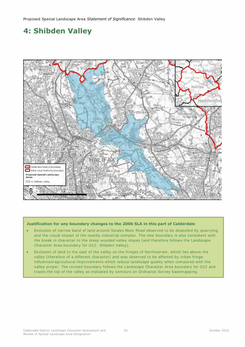
Proposed Special Landscape Area Statement of Significance: Shibden Valley
Calderdale District Landscape Character Assessment and
Review of Special Landscape Area Designation
81 October 2016
4: Shibden Valley
Justification for any boundary changes to the 2006 SLA in this part of Calderdale
Exclusion of narrow band of land around Swales Moor Road observed to be despoiled by quarrying
and the visual impact of the nearby industrial complex. The new boundary is also consistent with
the break in character to the steep wooded valley slopes (and therefore follows the Landscape
Character Area boundary for G12: Shibden Valley).
Exclusion of land to the east of the valley on the fringes of Northowram, which lies above the
valley (therefore of a different character) and was observed to be affected by urban fringe
influences/agricultural improvements which reduce landscape quality when compared with the
valley proper. The revised boundary follows the Landscape Character Area boundary for G12 and
traces the top of the valley as indicated by contours on Ordnance Survey basemapping.
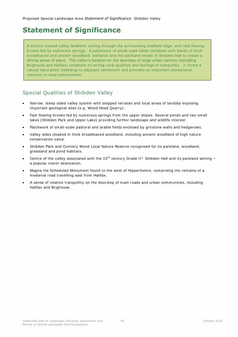
Proposed Special Landscape Area Statement of Significance: Shibden Valley
Calderdale District Landscape Character Assessment and
Review of Special Landscape Area Designation
82 October 2016
Statement of Significance
Special Qualities of Shibden Valley
Narrow, steep sided valley system with stepped terraces and local areas of landslip exposing
important geological sites (e.g. Wood Head Quarry).
Fast flowing brooks fed by numerous springs from the upper slopes. Several ponds and two small
lakes (Shibden Park and Upper Lake) providing further landscape and wildlife interest.
Patchwork of small-scale pastoral and arable fields enclosed by gritstone walls and hedgerows.
Valley sides cloaked in thick broadleaved woodland, including ancient woodland of high nature
conservation value.
Shibden Park and Cunnery Wood Local Nature Reserve recognised for its parkland, woodland,
grassland and pond habitats.
Centre of the valley associated with the 15th century Grade II* Shibden Hall and its parkland setting –
a popular visitor destination.
Magna Via Scheduled Monument found to the west of Hipperholme, comprising the remains of a
medieval road travelling east from Halifax.
A sense of relative tranquillity on the doorstep of main roads and urban communities, including
Halifax and Brighouse.
A distinct incised valley landform cutting through the surrounding coalfield edge, with fast flowing
brooks fed by numerous springs. A patchwork of small-scale fields combines with bands of thick
broadleaved and ancient woodland, wetlands and the parkland estate of Shibden Hall to create a
strong sense of place. The valley’s location on the doorstep of large urban centres (including
Brighouse and Halifax) enhances its strong rural qualities and feelings of tranquillity. It forms a
valued naturalistic backdrop to adjacent settlement and provides an important recreational
resource to local communities.
Proposed Special Landscape Area Statement of Significance: Shibden Valley
Calderdale District Landscape Character Assessment and
Review of Special Landscape Area Designation
83 October 2016
Summary information for the SLA parcel
Landscape Character
Assessment context (see
Appendix 1 for relevant
Landscape Character Area
profiles)
This proposed SLA parcel includes land within the following Landscape
Character Areas:
G12: Shibden Valley
As well as very small parts within:
K1: Coalfield Edge Urban Fringe Farmland (Thornton-Queensbury)
Criteria Summary description
Integrity/cohesiveness of
landscape character
This proposed SLA parcel forms a distinct incised valley landform cutting
through the surrounding higher land of the coalfield edge. It
encompasses land classified within Landscape Character Area G12:
Shibden Valley, also bringing in some small sections of upper valley
slopes within Landscape Character Area K1.
Local distinctiveness and sense
of place
The narrow, steep-sided valley cuts through the surrounding gently
undulating landscape to form a distinctive landform feature. Its
patchwork of woodlands, farmland, wetlands and the designed parkland
estate surrounding Shibden Hall create a strong sense of place. The SLA
parcel forms part of the backdrop and setting to Brighouse, Hipperholme
and Northowram.
Landscape quality Despite being close to urban development, the LCA is rural, tranquil and
naturalistic, particularly in the south of the valley near to Sutcliff Wood.
High levels of woodland cover and the enclosure provided by the steep
valley landform restricts views to nearby development. Traditional stone-
built and white-washed cottages and the Grade II* Shibden Hall and its
surrounding parkland estate (also managed as a Local Nature Reserve by
Calderdale Council) contribute to local distinctiveness and historic
character.
Scenic quality A secluded and tranquil character pervades as a result of the incised
landform, densely wooded slopes, streams and overall absence of modern
development. These qualities are particularly apparent given the valley’s
close proximity to urban development and main roads. The intimate
combination of woodland, farmland and historic built features in many
views contributes to the landscape’s valued scenic qualities.
Access and enjoyment Numerous footpaths and bridleways offer access to and within the valley,
including the Calderdale Way and Brighouse Boundary Walk. Shibden
Park is a popular visitor and recreational destination for both visitors and
the nearby urban communities (including Brighouse and Halifax).

Proposed Special Landscape Area Statement of Significance: Ringstone Edge and Norland Moor Fringes
Calderdale District Landscape Character Assessment and
Review of Special Landscape Area Designation
84 October 2016
5: Ringstone Edge and Norland Moor Fringes
Justification for any boundary changes to the 2006 SLA in this part of Calderdale
Addition of the valley west of Stainland – observed as of a tranquil, scenic and naturalistic
character (the small industrial estate within it is well integrated and screened) – and therefore
worthy of including in this SLA area.
Exclusion of Stainland Moor – field observations noted a proliferation of overhead cables, masts
and turbines. Stone walls were also poorly maintained and appeared to be crossed by a busy
commuter route, reducing levels of tranquillity. Generally assessed as being of lower landscape
quality when compared with the surrounding area of SLA.
Exclusion of small area of engineered embankment and M62 corridor on the authority boundary
west of Scammonden Water.
Proposed Special Landscape Area Statement of Significance: Ringstone Edge and Norland Moor Fringes
Calderdale District Landscape Character Assessment and
Review of Special Landscape Area Designation
85 October 2016
Statement of Significance
Special Qualities of Ringstone Edge and Norland Moor Fringes
Undulating elevated land with some steep slopes and pockets of remnant moorland. Owlet Edge
forms a prominent landform on the boundary with Kirklees.
Small streams and cloughs carving through the landscape to feed the adjacent Ryburn and Calder
valleys.
Characteristic pattern of upland pastures traditionally enclosed by gritstone walls.
Bands of woodland providing naturalistic land cover and nature conservation interest.
Patches of bracken, rough grassland and gorse scrub evoking an upland feel; an expanse of heather
moorland found at Norland Moor Local Nature Reserve.
Strong vernacular of local stone and slate displayed in scattered farmsteads, isolated dwellings and
small hamlets.
Disused quarries, pits and former mill buildings providing evidence of an industrial past. Prehistoric
cairns and tumuli of national importance on Ringstone Edge Moor.
Strong intervisibility with the moorland summits characterising the south-west of the district,
including Rishworth and Moss Moors.
Open, upland fringe landscape character, often conveying a relative sense of remoteness and
isolation (especially when compared with the settled valleys nearby).
Forms an elevated rural setting to the valley settlements of Ripponden, Sowerby Bridge and Copley,
including their historic Conservation Areas.
A transitional upland fringe landscape rising up steeply from the settled Ryburn Valley to the west
and the busy Calder Valley to the north. It forms an important transition from the prominent
upland moorlands that characterise western Calderdale, to the developed eastern part of the
district associated with Halifax and its suburbs focused on the Calder Valley. The landscape has a
strong historic sense of place and traditional character, with a geometric pattern of walled upland
fringe pastures, pockets of remnant moorland and sparse settlement interspersed by industrial
relics. It has strong visual connections both to the open, remote uplands to the west and the
busy, developed valleys below – forming a distinctive backdrop to Ripponden, Sowerby Bridge and
Copley, including their Conservation Areas.
Proposed Special Landscape Area Statement of Significance: Ringstone Edge and Norland Moor Fringes
Calderdale District Landscape Character Assessment and
Review of Special Landscape Area Designation
86 October 2016
Summary information for the SLA parcel
Landscape Character
Assessment context (see
Appendix 1 for relevant
Landscape Character Area
profiles)
This proposed SLA area includes land within the following Landscape
Character Areas:
E2: Barkisland-Holywell Green
D2: Blackwood Common
As well as small parts within:
F2: Calder (Walsden, Todmorden, Hebden Bridge, Mytholmroyd)
F3: Ryburn (Sowerby Bridge, Ripponden)
Criteria Summary description
Integrity/cohesiveness of
landscape character
A transitional upland fringe landscape rising up steeply from the settled
Ryburn Valley to the west and the busy Calder Valley to the north. Its
eastern extent marks the change to a more settled, urban fringe
landscape surrounding Elland and Greetland – southern suburbs of
Halifax. The SLA parcel straddles across parts of two main Landscape
Character Areas: E2: Barkiland-Holywell Green and D2: Blackwood
Common. Some steep slopes rising up from the valleys below are also
included (within F2: Calder and F3: Ryburn).
Local distinctiveness and sense
of place
This SLA parcel forms an important transition from the prominent upland
moorlands that characterise western Calderdale, to the developed eastern
part of the district associated with Halifax and its suburbs focused on the
Calder Valley. The landscape has a strong historic sense of place and
traditional character, with a geometric pattern of walled upland fringe
pastures, pockets of remnant moorland and sparse settlement
interspersed by industrial relics. It has strong visual connections both to
the open, remote uplands to the west and the busy, developed valleys
below – forming a distinctive backdrop to Ripponden, Sowerby Bridge and
Copley, including their Conservation Areas.
Landscape quality The combination of the intact pattern of walled pastures, unifying
gritstone vernacular, industrial relics, upland fringe habitats (including
remnant moorland) and long, open views creates an important
transitional landscape with strong physical and cultural links to the
surrounding uplands and valleys. Traditional character and a sense of
time depth prevail despite the close proximity of dense urban
development.
Small scale farm turbines of various sizes, pylons and masts can impact
on local landscape quality and traditional character in parts, although
these do not have an overbearing influence on the landscape as a whole.
Scenic quality The landscape’s combination of traditional rural qualities and long, open
views often to an upland backdrop define character and important scenic
qualities.
Access and enjoyment The landscape and its small settlements are linked by a dense network of
footpaths and bridleways, including the Calderdale Way. Good road
access also means that the rural landscape is easily accessible from
nearby communities.
There are also several areas of Open Access Land.
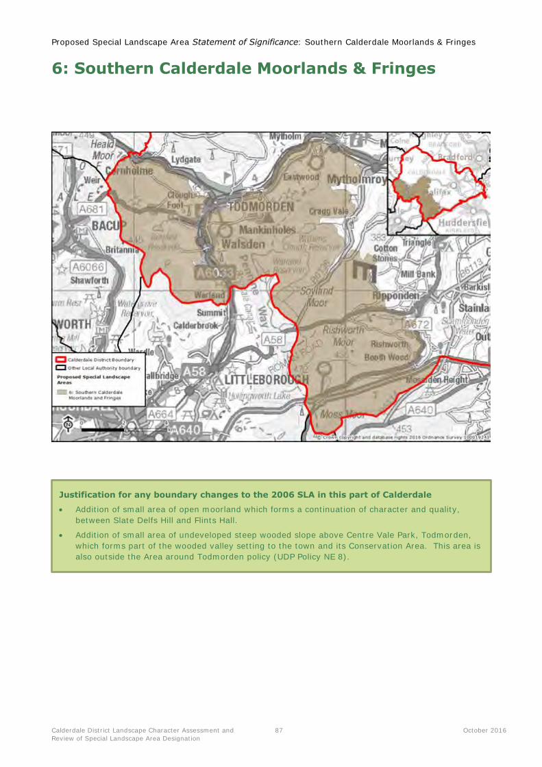
Proposed Special Landscape Area Statement of Significance: Southern Calderdale Moorlands & Fringes
Calderdale District Landscape Character Assessment and
Review of Special Landscape Area Designation
87 October 2016
6: Southern Calderdale Moorlands & Fringes
Justification for any boundary changes to the 2006 SLA in this part of Calderdale
Addition of small area of open moorland which forms a continuation of character and quality,
between Slate Delfs Hill and Flints Hall.
Addition of small area of undeveloped steep wooded slope above Centre Vale Park, Todmorden,
which forms part of the wooded valley setting to the town and its Conservation Area. This area is
also outside the Area around Todmorden policy (UDP Policy NE 8).
Proposed Special Landscape Area Statement of Significance: Southern Calderdale Moorlands & Fringes
Calderdale District Landscape Character Assessment and
Review of Special Landscape Area Designation
88 October 2016
Statement of Significance
Special Qualities of the Southern Calderdale Moorlands & Fringes
Series of elevated moors forming large scale sweeping plateaux, surrounded by a strong pattern of
upland pastures enclosed by gritstone walls.
Underlying Millstone Grit geology creating distinctive physical features such as frost weathered tors.
Incised by numerous small-scale stream valleys, cloughs and waterfalls.
Large parts within the South Pennine Moors SAC, SPA and SSSI, recognised for important heathland,
bogs and fens supporting rich upland breeding bird populations.
Species-rich hay meadows, rush pastures and wet woodlands providing further wildlife interest and
texture.
Strong sense of time depth with many Scheduled Monuments representing human interaction with
the landscape over millennia.
Dispersed settlement pattern fringing the moors, with scattered traditional stone farmsteads and
occasional historic villages.
A landscape providing artistic and literary inspiration throughout the centuries – famously associated
with the Brontës.
Strong perceptions of remoteness, isolation and wildness in contrast to the busy Calder and Ryburn
valleys.
Landscape forming a dramatic upland setting to valley settlements.
Expansive views owing to elevation – including south towards the Peak District National Park.
A series of open moorland plateaux and fringing upland pastures located in south-west Calderdale,
rising above the main Calder Valley. The landscape forms a distinctive upland backdrop to large
parts of the District, including the busy valley settlements of Todmorden, Ripponden, Hebden
Bridge and Mytholmroyd. A perception of remoteness, isolation and wildness prevails on the
moors, whilst a sense of timelessness is associated with the sparsely settled upland pastures with
strong gritstone vernacular. The moorlands continue south into Rochdale District; part of the
wider upland spine of the South Pennines linking the Peak District and Yorkshire Dales National
Parks.
Proposed Special Landscape Area Statement of Significance: Southern Calderdale Moorlands & Fringes
Calderdale District Landscape Character Assessment and
Review of Special Landscape Area Designation
89 October 2016
Summary information for the SLA area
Landscape Character Assessment context (see
Appendix 1 for relevant Landscape Character Area profiles)
This proposed SLA area includes land within the following Landscape
Character Areas:
A1: South Pennine Moors
D1: Calder Terrace
D4: Scout Moor and Shore Moor Fringe
As well as small parts within:
D2: Blackwood Common
G3: Cliviger Gorge
F2: Calder (Walsden, Todmorden, Hebden Bridge, Mytholmroyd)
D7: Peak Fringe Upland Pastures
Criteria Summary description
Integrity/cohesiveness of
landscape character
This proposed SLA area covers the series of open moorland plateaux found
across north-west Calderdale, south of the main Calder Valley which forms a
natural boundary to the north. It includes the enclosed upland pastures that
fringe the moors, landscapes which have strong visual and cultural
connections with the open moorlands. Much of the SLA area is consistent
with the landscape character assessment classification of A1: South Pennine
Moors, D1: Calder Terrace and D4: Scout Moor and Scout Moor Fringe.
Local distinctiveness and
sense of place
The SLA area frames and forms a distinctive upland backdrop to much of
Calderdale District, with high levels of intervisibility between the moorlands
and upland fringes which collectively form the area. The uplands overlook
Todmorden, Hebden Bridge, Mytholmroyd and Ripponden, providing a
dramatic upland setting to the valley settlements. Stoodley Pike Monument
forms a prominent landmark standing above Todmorden, featuring in many
views from across the district. The moorlands provide artistic and literary
inspiration to many, famously associated with the Brontës.
Landscape quality The uplands offer open expanses of unbroken grass and heather moorlands,
surrounded by a strong geometric pattern of historic sheep pastures and
species-rich hay meadows. The distinctive gritstone walls enclosing the
pastures unify with the local vernacular of upland farms and historic villages.
Landscape quality has been affected locally by the introduction of wind
turbines (including clear views to Coal Clough wind farm in Burnley district),
telecommunication masts and pylons breaking open skylines, although these
do not have an overbearing influence on the landscape as a whole.
Scenic quality The landscape forms an integral part of the wider upland spine of the South
Pennines, extending from the Peak District to the south to the Yorkshire
Dales to the north. Long views are afforded south across the moorlands of
Rochdale District towards the Peak District; the open moorland character
flowing across the district boundary and beyond.
A perception of remoteness, isolation and wildness is evoked by the altitude,
absence of trees and settlements across the moorlands, with a sense of
timelessness often associated with the historic upland pastures.
Access and enjoyment Numerous paths, often based upon historic packhorse routes, cross through
the landscape linking the moors with surrounding settlements. These include
the Pennine Way, Pennine Bridleway, Calderdale Way and Todmorden
Centenary Way. Large parts of the unenclosed moorlands are also Open
Access Land. The SLA area offers a valued and accessible recreational
resource on the doorstep of nearby communities, as well as a draw for
visitors to the area.
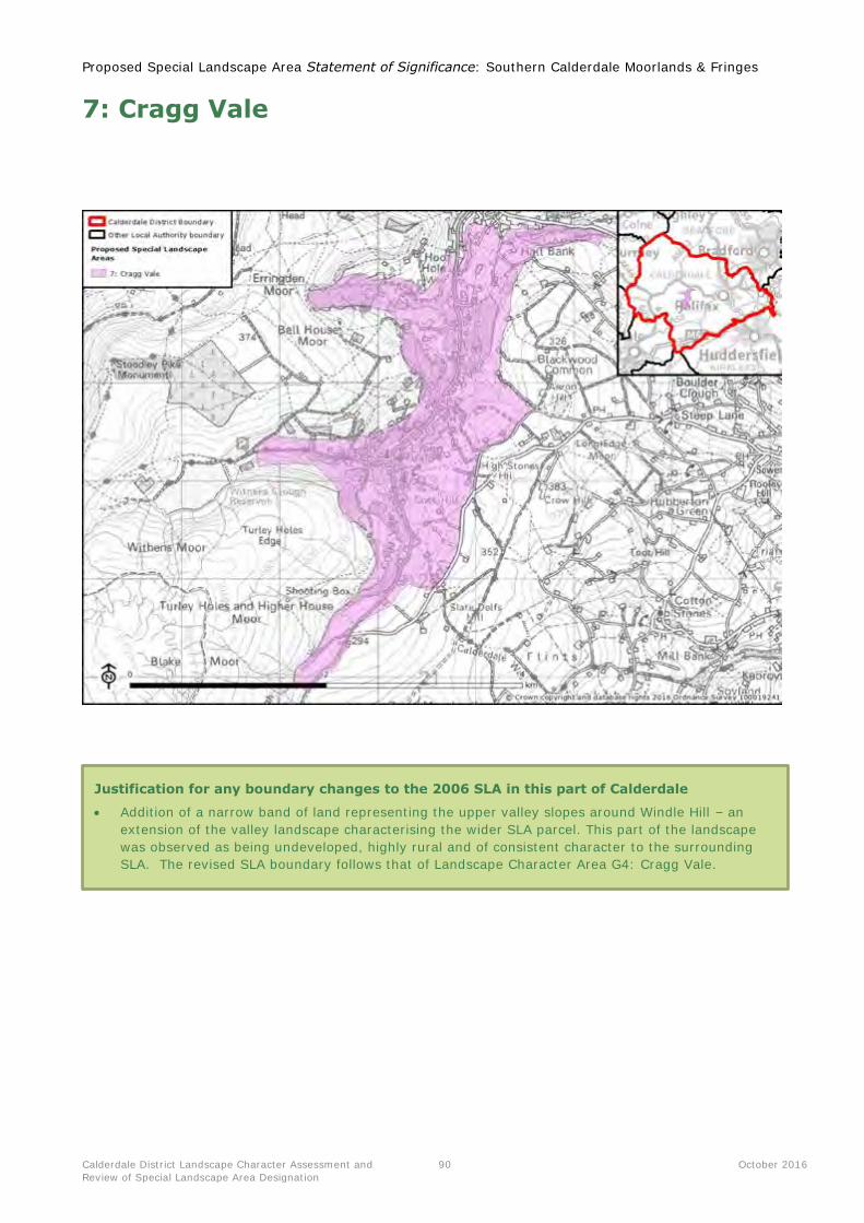
Proposed Special Landscape Area Statement of Significance: Southern Calderdale Moorlands & Fringes
Calderdale District Landscape Character Assessment and
Review of Special Landscape Area Designation
90 October 2016
7: Cragg Vale
Justification for any boundary changes to the 2006 SLA in this part of Calderdale
Addition of a narrow band of land representing the upper valley slopes around Windle Hill – an
extension of the valley landscape characterising the wider SLA parcel. This part of the landscape
was observed as being undeveloped, highly rural and of consistent character to the surrounding
SLA. The revised SLA boundary follows that of Landscape Character Area G4: Cragg Vale.
Proposed Special Landscape Area Statement of Significance: Southern Calderdale Moorlands & Fringes
Calderdale District Landscape Character Assessment and
Review of Special Landscape Area Designation
91 October 2016
Statement of Significance
Special Qualities of Cragg Vale
Fast flowing stream of Cragg Brook, carving a steep valley through the underlying Millstone Grit.
Springs, waterfalls and weirs are located along the brook.
Numerous areas of broadleaved woodland along the valley sides, much of ancient origin. Wetland
habitats are also of nature conservation interest, including freshwater streams and rush pastures.
Broadhead Clough SSSI and valued for its moorland, woodland and acid grassland habitats.
Historic mills and weirs along the valley floor providing evidence of the valley’s industrial heritage.
Associated with the infamous Cragg Vale Coiners gang of counterfeiters from the 1760s.
Provides a wooded setting to the Mytholmroyd Conservation Area.
A rural, pastoral character created by a patchwork of fields and woodland and sparse settlement.
Historic, gritstone local vernacular reflected in the sparse settlement pattern of isolated farmsteads,
cottages and stone wall field boundaries.
Immediately overlooked by Bell House Moor and Turley Holes Edge, forming strong undeveloped
skylines crowned by woodland and open expanses of moorland.
Deep upland valley of Cragg Vale, drained by the fast-flowing Cragg Brook flowing from its
moorland source to meet the Calder Valley at the historic settlement of Mytholmroyd. A strong
sense of enclosure and intimacy stands in contrast to the large-scale open moorlands found
immediately adjacent to the south and west. Weirs and other built features provide important
traces of the area’s industrial heritage, whilst legends associated with the Cragg Vale Coiners are
strongly associated with the area. The valley provides an attractive wooded setting to the
Mytholmroyd Conservation Area, with footpaths and the Calderdale Way providing access through
the valley to the moorlands beyond.
Proposed Special Landscape Area Statement of Significance: Southern Calderdale Moorlands & Fringes
Calderdale District Landscape Character Assessment and
Review of Special Landscape Area Designation
92 October 2016
Summary information for the SLA parcel
Landscape Character
Assessment context (see
Appendix 1 for relevant
Landscape Character Area
profiles)
This proposed SLA parcel includes land within the following Landscape
Character Areas:
G4: Cragg Vale
As well as small parts within:
D2: Blackwood Common
A1: South Pennine Moors
F2: Calder (Todomrden, Hebden Bridge, Mytholmroyd)
Criteria Summary description
Integrity/cohesiveness of
landscape character
This proposed SLA parcel covers the incised valley of Cragg Vale, a
tributary of the Calder. Much of the SLA area is consistent with the
landscape character assessment classification of G4: Cragg Vale, with
some additional valley slopes brought in from the surrounding LCAs of
D2, A1 and F2.
Local distinctiveness and sense
of place
This steep-sided, branching tributary valley of Cragg Vale carves through
the surrounding moorlands, its fast flowing brook flowing north to meet
the Calder at Mytholmroyd. Its strong sense of enclosure and intimate
scale stands in contrast to the large-scale open moorlands found
immediately adjacent to the south and west. Weirs and other built
features provide important traces of the area’s industrial heritage, whilst
legends associated with the Cragg Vale Coiners are strongly associated
with the Vale. The valley provides an attractive wooded setting to the
Mytholmroyd Conservation Area.
Landscape quality A strongly rural and tranquil landscape with few modern influences and
sparse historic settlement of scattered stone-built farms and dwellings.
The characteristic patchwork of pasture fields, woodlands and wetlands
stands in contrast both to the exposed open moorland above, and the
busy, densely developed character of the Calder Valley to the north.
Scenic quality An archetypal deep upland valley with a diverse combination of natural
habitats and historic relics, affording scenic glimpses to small pastures
and woodlands along the valley as well as the remote uplands of the
surrounding moorlands. A strong sense of relative tranquillity and shelter
pervades, particularly valued given proximity to dense development in
the Calder Valley.
Access and enjoyment A dense network of footpaths provides access along and across the
valley, including from the settlement of Mytholmroyd. The Calderdale
Way crosses east-west through the valley, linking to the surrounding
moorlands and popular Witchens Clough Reservoir. Broadhead Clough
Nature Reserve, managed by Yorkshire Wildlife Trust, provides
opportunities for enjoying the landscape’s wildlife.
Small patches of Open Access Land are found at the top of the valley
adjacent to the uplands.