By Vinod Kumar IAS Commissioner Land Records & Settlement, Madhya Pradesh December 15-17, 2009, New...
22
By Vinod Kumar IAS Commissioner Land Records & Settlement, Madhya Pradesh December 15-17, 2009, New Delhi Enterprise WebGIS Solution for Managing Land Records
-
Upload
elijah-burns -
Category
Documents
-
view
215 -
download
2
Transcript of By Vinod Kumar IAS Commissioner Land Records & Settlement, Madhya Pradesh December 15-17, 2009, New...

By Vinod Kumar IAS
Commissioner Land Records & Settlement, Madhya Pradesh
December 15-17, 2009, New Delhi
Enterprise WebGIS Solution for Managing Land Records

MP Land Records: Quick Facts
Area > 3 Lakh sqkms Fifty Districts Population > 6Cr Population density
200 people per sqkm No of parcels > 3.7 Cr

MP Land Records: Quick Facts
Broad Landuse

Major Activities of the Department
Nazul Land Receive and Process
applications Premium and Rent
Demand Generation Collection
Issue Copy of Land Records Receive and Process
Applications Khasra Map B1 Register
Mutation Land Revenue
Rent Demand Generation Collection
Diversion of Land Receive and Process
applications Premium and Rent
Demand Generation Collection

Objectives of the Project To have a centralized and highly secured storage of land records To utilize latest advancements in Geospatial industry in preserving
and using digital land records data To link map data and attribute data To have a controlled multi location data update facility To have full function Audit Trails will drill down reporting facility To develop an Enterprise Solution to Manage Land Records and to
provide Citizen Services To establish and Run Tehsil level IT Centres to provide better and
quicker services to the public Integration with other departments Issue Smart cards for Land Owners
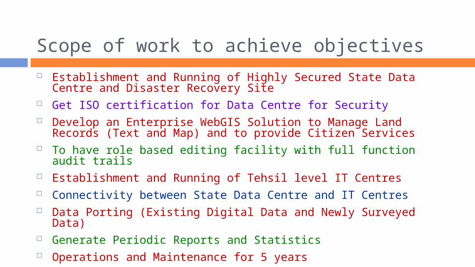
Scope of work to achieve objectives Establishment and Running of Highly Secured State Data Centre
and Disaster Recovery Site Get ISO certification for Data Centre for Security Develop an Enterprise WebGIS Solution to Manage Land Records
(Text and Map) and to provide Citizen Services To have role based editing facility with full function audit trails Establishment and Running of Tehsil level IT Centres Connectivity between State Data Centre and IT Centres Data Porting (Existing Digital Data and Newly Surveyed Data) Generate Periodic Reports and Statistics Operations and Maintenance for 5 years

Conceptual Design
Data Centre
DR SiteDepartment Users Loc 1
IT Centre 1
Public Counters
Data Update Users
IT Centre n
Public Counters
Data Update Users
Department Users Loc n
Special Users (Other Departments)
Public Users
Internet
Leased LineBroadband
VPN

Land Records State Data Centre
Objective Host Data and
Application in a centralized manner
Scope of work Design and
Establishment of Data Centre
Get ISO Certification for Security
Running and Maintenance for 5 years
Highlights High Data Security Features High Capacity Design High Availability Design
Disaster Recovery Data Centre High band width VPN
connectivity with DC Synchronous Data Mirroring
(SAN based) In different Seismic Zone

Enterprise WebGIS Solution
Objective Application to manage
digital land records including editing
Application to provide citizen services
Scope of work Design, Development
and Implementation Running and
Maintenance for 5 years
Highlights Centralized Web-based GIS
Solution Role based access control High security features Integrated Biometric
Authentication Faster citizen services
through IT centres as well as through internet
Multi-user, multi location editing with audit trails

Tehsil level IT Centers (338 in Number)
Objective Editing of data Interface for citizen
services Scope
Design and Establishment
Running and Maintenance for 5 years
Highlights Shorter service
time Biometric
authentication while posting edits to the server
Single window for citizen services

Data Porting
Solution design ensures working with Existing data being
digitized after data porting exercise
New data to be surveyed
Scope includes: Porting of data Performing data
quality checks of the data before posting the data to the live server

Tender for executing the work
Highlight Probably the
FIRST ever released tender in PPP BOOT model for managing land records in India
Two Step Process Technical Bid Commercial Bid
Cost and Quality Based Selection Procedures

Technical Evaluation of Bids Bidder’s Competence
Financial Stability Experience in WebGIS Experience in Cadastral
Mapping Certifications
Quality of Solution Design and Architecture Approach and Methodology
Quality of Resources Human Resources Proposed Team

Steps involved in Execution: Data Centre Delivery, Installation,
Configuration and Testing Plans
Delivery of materials Installation, Configuration
and Testing Pilot Run Disaster Recovery Mock Run Full Roll out Training Security Audit Commissioning
Technical Committee Reviews at each
stage Adherence to
Technical specifications
Adherence to timelines
Performance Review Project Management Monitoring and
Control

Steps involved in Execution: GIS Application
Detailed Project Plan Requirement Analysis Design Coding Unit, Module, System and
Integration Testing User Acceptance Testing Full Function Rollout –
Pilot Locations Training Full Function Rollout – All
locations
Technical Committee Reviews at each
stage Adherence to
Technical specifications
Adherence to timelines
Performance Review Project Management Monitoring and
Control
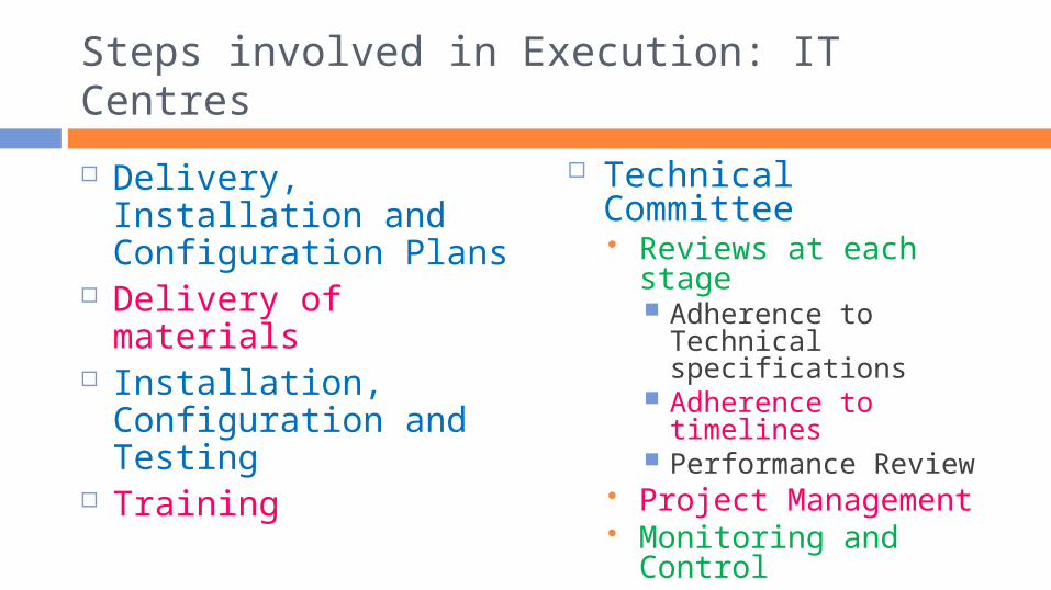
Steps involved in Execution: IT Centres
Delivery, Installation and Configuration Plans
Delivery of materials
Installation, Configuration and Testing
Training
Technical Committee Reviews at each
stage Adherence to
Technical specifications
Adherence to timelines
Performance Review Project Management Monitoring and
Control

Operations and Maintenance Period
Supply of required man power to operate the system for all functionalities
Bug fixing, error corrections Periodic data validations Enhancements to the application Generate Reports and statistics

Highlights of PPP BOOT Model
All cost to be borne by the vendor
Vendor shall be paid fixed amounts (computed as per his winning bid amount) upon each service operation
Vendor is responsible for maintenance

Expected Benefits to the Citizen
Tehsil level single window service counters Internet services
File applications Make payments Take Land Records Copy (Map and Text)
SMS Services Payment due date reminders and payment confirmation Land record details by return SMS
Smart card for ownership Overall quicker and better services, Transparent
procedures

Expected Benefits to the department
Better Data Management Better Data Handling Ease in Processing Applications Ease in Data Retrieval No need to trace the map for taking copies Uniformity in Procedures and Processes Better Control over Data and Process Easy Retrieval of Historical Transactions
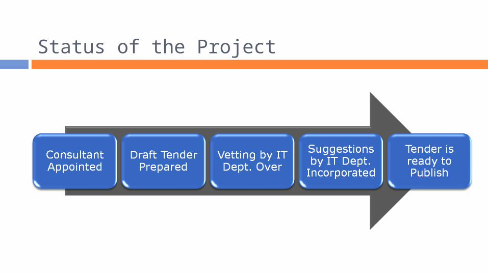
Status of the Project

Thanks! For more information
E-mail : [email protected] Phone : +91 751 2441200 Web Site: www.landrecords.mp.gov.in