D2.1.2: Central webGIS Prototype and users guide
15
D2.1.2: Central webGIS Prototype and users guide WP2.1 – webGIS integrating platform, user interface Juan Manuel Moreno, Alfonso Calera, Anna Osann, José González (UCLM) First version – M12 This project has received funding from the European Union’s Horizon 2020 research and innovation programme under grant agreement No 633945.
-
Upload
nguyenthuan -
Category
Documents
-
view
235 -
download
2
Transcript of D2.1.2: Central webGIS Prototype and users guide

D2.1.2: Central webGIS Prototype and users guide
WP2.1 – webGIS integrating platform, user interface
Juan Manuel Moreno, Alfonso Calera, Anna Osann, José González (UCLM)
First version – M12
This project has received funding from the European Union’s Horizon 2020 research and innovation programme under grant agreement No 633945.

D2.1.2 Central webGIS prototype and users guide 27/02/2016 v03
2 | 15
Document Information Grant Agreement Number 633945 Acronym FATIMA Full Title of Project Farming Tools for external nutrient inputs and water Management Horizon 2020 Call SFS-‐02a-‐2014: External nutrient inputs (Research and innovation Action) Start Date 1 March 2015 Duration 36 months Project website www.fatima-‐h2020.eu Document URL (insert URL if document is publicly available online) REA Project Officer Aneta RYNIAK Project Coordinator Anna Osann Deliverable D2.1.2 Central webGIS prototype and users guide Work Package WP2.1 – webGIS integrating platform, user interface Date of Delivery Contractual 1 March 2016 Actual 1 March 2016 Nature R -‐ Report Dissemination Level PU Lead Beneficiary 01_UCLM Lead Author Juan Manuel Moreno (UCLM)
(UCLM) Email [email protected]
Contributions from Alfonso Calera, Anna Osann, José González Internal Reviewer 1 Konstantinos Soulis (AUA) Internal Reviewer 2 Paco Morell (INRA) Objective of document To document SPIDER prototype for FATIMA project.
Readership/Distribution All FATIMA Regional Teams; All WP leaders and other FATIMA team members; European Commission / REA
Keywords webGIS, user requirements, conceptual design, co-‐creation Document History
Version Issue Date Stage Changes Contributor v01 25/01/2016 Draft Juan Manuel Moreno
V02 18/02/2016 Alfonso Calera
V03 27/02/2016 internal reviewers’ and contributors’ comments integrated
Anna Osann
Disclaimer
Any dissemination of results reflects only the authors’ view and the European Commission is not responsible for any use that may be made of the information it contains.
Copyright
© FATIMA Consortium, 2015 This deliverable contains original unpublished work except where clearly indicated otherwise. Acknowledgement of previously published material and of the work of others has been made through appropriate citation, quotation or
both. Reproduction is authorised provided the source is acknowledged. Creative Commons licensing level
D2.1.2 Central webGIS prototype and users guide 27/02/2016 v03
3 | 15
Executive summary
This document presents the central webGIS prototype and users guide implemented in FATIMA. The platform prototype is based on an enhanced and adapted version of the webGIS SPIDER (System of Participatory Information, Decision support and Expert knowledge for irrigation River basin water management), a web-‐based GIS tool, which has been operational for many years. Here we focus on features already available that are of interest to FATIMA and the work done in the first year of FATIMA. We also highlight some future work to be done. This document intends to fill the gap between the actual practitioners and the software development experts.
The current version (v03) reflects the status of M12. The integration of further functionalities will lead to updates of the system, which will be documented in a subsequent document version.

D2.1.2 Central webGIS prototype and users guide 27/02/2016 v03
4 | 15
Table of Contents Executive summary ........................................................................................................................................... 3
1 Central WebGIS hub prototype ................................................................................................................. 5
1.1 WebGIS SPIDER. Main characteristics .............................................................................................. 6
1.1.1 Handling maps ........................................................................................................................... 7
1.1.2 Management of user groups ..................................................................................................... 7
1.1.3 Sensor data integration ............................................................................................................. 9
1.1.4 New graphics chart for mobile devices ................................................................................... 10
1.1.5 Other technical improvements ................................................................................................ 10
1.1.6 SPIDERwebGIS.org ................................................................................................................... 11
1.2 Achievement of technical functionalities ....................................................................................... 13
1.3 Future work .................................................................................................................................... 13
1.3.1 Full mobile devices support (Responsive Design) .................................................................... 14
1.3.2 Overlay algebra refactored and working ................................................................................. 14
1.3.3 Calculator integrated in SPIDER client and in the new chart ................................................... 14
1.3.4 Documentation updated ......................................................................................................... 14
1.4 SPIDER Support and community .................................................................................................... 15
D2.1.2 Central webGIS prototype and users guide 27/02/2016 v03
5 | 15
1 Central WebGIS hub prototype
This document presents the central webGIS hub prototype development and assembly implemented in FATIMA. We define this central webGIS as a scalable infrastructure that allows the deployment of a state-‐of-‐art framework enabling users (with various skills) to work cooperatively, securely, and easily and to access, retrieve, analyze, and disseminate geospatial data in an on-‐demand mode.
Accordingly, we document here the first beta version of this prototype. This report includes elements of the conceptual design, the user’s requirements, and the conclusions of a comparative analysis with other similar systems, as well as elements which were addressed in the previous deliverable D2.1.1.
The developed platform prototype, called SPIDER webGIS, is based on an enhanced and adapted version of the SPIDER (System of Participatory Information, Decision support and Expert knowledge for irrigation River basin water management). SPIDER is a web-‐based GIS tool, which has been operational for several years, developed in previous projects (www.pleiades.es, www.sirius-‐gmes.es).
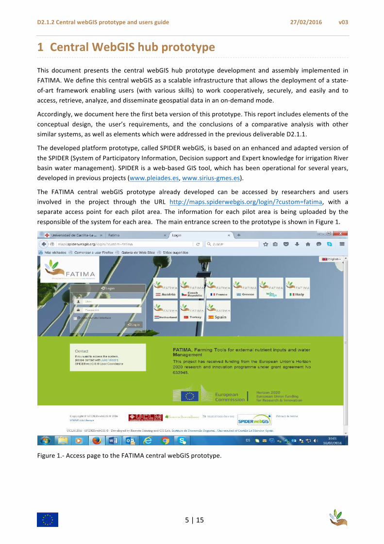
The FATIMA central webGIS prototype already developed can be accessed by researchers and users involved in the project through the URL http://maps.spiderwebgis.org/login/?custom=fatima, with a separate access point for each pilot area. The information for each pilot area is being uploaded by the responsible of the system for each area. The main entrance screen to the prototype is shown in Figure 1.
Figure 1.-‐ Access page to the FATIMA central webGIS prototype.

D2.1.2 Central webGIS prototype and users guide 27/02/2016 v03
6 | 15
1.1 WebGIS SPIDER. Main characteristics
Recalling from the conceptual design (deliverable D2.1.1), the central information and communication hub of FATIMA needs to manage, handle, and display maps and data from Earth Observation (EO), models, and ground sensors to produce web-‐ or smartphone-‐accessible information and tools for irrigation scheduling, fertilizer and yield management, and integrated/holistic precision farming. The system receives information from multiple sources, and it processes and distributes them back to users (e.g., farmers and farm consultants) via multiple channels (web and mobile interface). The main data types for upload, handling and visualization are
1) basic GIS layers (administrative and cadastral boundaries, roadmap, water bodies, etc.);
2) EO images and derived information products (maps of crop/vegetation water consumption and requirements, color composite maps of plant water status, etc.);
3) model output (e.g., HidroMORE spatialized water balance, weather prediction);
4) water and yield calculators;
5) sensor networks (soil moisture, plant water status, etc.);
6) water and nutrients accounting.
The following table (Table 1), taken from D2.1.1, shows a summary of the basic products provided to the stakeholders according to the users requirements.
Table 1.-‐ Summary of products based on the users requirements (originally presented in D2.1.1)
Time frame
Decisions to make Products Delivery of products
Short term
Crop Monitoring
How much water next week?
How much nutrients and its spatial distribution?
Time series of images + ground sensors + weather
Maps of crop water requirements next week
Maps of crop nutrients requirements
webGIS
Medium term/
Long term
Cropping system/crop rotation/no tillage/organic and conservation agriculture
Planning the crop: Seed/ Density/ Main labors/ Climate, Water and Nutrients/Manure management
Assessment for optimum yield through economic analysis including policies and environmental constraints
Reports/
Manuals
webGIS
According to the above presented requirements, the prototype developed here is able to share, display, and handle maps interacting with the service providers. The developed software is open source.

D2.1.2 Central webGIS prototype and users guide 27/02/2016 v03
7 | 15
1.1.1 Handling maps
The core of the webGIS SPIDER system for handling maps is MapServer, http://mapserver.org/ , an Open Source platform for publishing spatial data and interactive mapping applications to the web. Originally developed in the mid-‐1990’s at the University of Minnesota, MapServer is released under an MIT-‐style license, and runs on all major platforms (Windows, Linux, Mac OS X). The MapServer version currently used in SPIDER is 6.4.
One of the direct consequences of this MapServer version is the support for multi Coordinates Reference Systems (CRS). One of the limitations of previous SPIDER versions was that data providers needed to choose one CRS for all data in a region or group. This was challenging for areas located at the limit of different projections, forcing to choose one of them. The new version allows providing data in multi projection regions by combining different CRS if needed. This reduces the time for the production chain and mitigates errors produced by reprojection tasks.
Improvements in the management of time series of images in their own CRS have been achieved by using the tile-‐index functionality. A tile-‐index is a shapefile that ties together several datasets into a single layer. Therefore, there is no need to create separate layers for each map. MapServer pieces the mosaic together on the fly. In SPIDER we apply this concept to the time series of images, supporting also multi CRS, calling these layers Virtual tiles. This concept simplifies the required steps to upload time series of images, i.e. satellite images, model outputs etc., thus automating some of the steps that were required in previous SPIDER versions.
To offer support to this new way of managing time series, a new and improved interface was introduced in this part of the administration back-‐end. It is easier to use and administrators do not need to manage the tile index like in previous versions. Now the SPIDER server side is in charge of doing this. Also the updating interface, in order to maintain and update this kind of layers, has been improved. This was critical for users maintaining data in SPIDER, as they need to update tiles every time a new image becomes available. To help with this maintenance tasks, a new search tool was included to filter images already uploaded. With this new interface, administrators are also able to share satellite data between different groups. Accordingly, uploading of all images that belong to all pilot areas can be done in only one layer.
MapServer v6.4 also includes the necessary tools to integrate support to KML/GML formats. Previous versions of SPIDER had exporting tools to KML, but they were developed based on external components from projects that did not continue, loosing support for them. Also, the integration of these components was complicated and required significant effort from the development team. Having integrated KML/GML support to this MapServer version, the future developments based on these formats will require reduced time and effort. These developments are critical to improve field support in SPIDER.
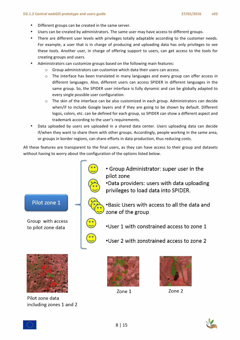
1.1.2 Management of user groups
One of the most relevant features is the management of user groups and sharing of data sources. The main characteristics of this feature are:
D2.1.2 Central webGIS prototype and users guide 27/02/2016 v03
8 | 15
• Different groups can be created in the same server. • Users can be created by administrators. The same user may have access to different groups. • There are different user levels with privileges totally adaptable according to the customer needs.
For example, a user that is in charge of producing and uploading data has only privileges to see these tools. Another user, in charge of offering support to users, can get access to the tools for creating groups and users.
• Administrators can customize groups based on the following main features: o Group administrators can customize which data their users can access. o The interface has been translated in many languages and every group can offer access in
different languages. Also, different users can access SPIDER in different languages in the same group. So, the SPIDER user interface is fully dynamic and can be globally adapted to every single possible user configuration.
o The skin of the interface can be also customized in each group. Administrators can decide when/if to include Google layers and if they are going to be shown by default. Different logos, colors, etc. can be defined for each group, so SPIDER can show a different aspect and trademark according to the user’s requirements.
• Data uploaded by users are uploaded in a shared data center. Users uploading data can decide if/when they want to share them with other groups. Accordingly, people working in the same area, or groups in border regions, can share efforts in data production, thus reducing costs.
All these features are transparent to the final users, as they can have access to their group and datasets without having to worry about the configuration of the options listed below.

D2.1.2 Central webGIS prototype and users guide 27/02/2016 v03
9 | 15
Group management is easier in the current version. The available groups are filtered according to the user introduced. In this way, a user can get a quick overview of the groups to which she/he has access. SPIDER offers the option of configuring different groups to share the same data in order to be able to use them many times with different purposes.
Another improvement in the way a user can access SPIDER, is the development of an administrator for customized entry screens. Each relevant group may get a customized entry screen, so that the layout of the SPIDER entry screen is better integrated in the hosting webpage or platform. The inclusion of this administrator feature facilitates the design of such customized entry screens.
1.1.3 Sensor data integration
Sensor data integration is one of the crucial goals of FATIMA project. Therefore, connectivity evaluation has been performed based on the following sensor data providers:
FOODIE sensors network connection tested and available,
BQ network sensors connection evaluated and protocols for communication defined,
Ranch Systems also contacted and access obtained to API developers (pending).
The idea is to focus on sensor data providers, as SPIDER goals are not to link with every single sensor type. SPIDER development focuses on data providers that offer data for FATIMA pilot areas, or at least for some of them, like the Spanish (BQ and RanchSystems) and Chech (FOODIE project platform) pilot areas. In order to accomplish this task, continuous development work is conducted with BQ. For the purpose of FOODIE collaboration, a technical meeting was held during the Hackathon ISAF 2015 in Dresden (http://www.isaf2015.info/?page_id=106). During this meeting the basic connection layer was developed.
The conclusions based on these works are:
GeoJSON the standard for integrating different sensor networks: currently none of the sensor data providers we evaluated are capable of offering data based on OGC standards, so GeoJSON was chosen as the basic communication standard.
Prototypes for high interactivity are necessary: it is compulsory to get feedback from users quickly, as integrating data from satellite (daily basis) and sensors (minute basis), presents a challenge as defining how to work with different time scales is not straightforward.
Different ways of integrating (displaying) sensors: not all data providers offer the same information about sensors types and how to display them. For users, an appropriate sensor representation can help understand what kind of sensor they are querying. So a list of sensor types and how to display them was made:
Stations and tracks are easy points/lines to display;
Pivot motion sensors (rounded and parallel ones) should show the recent path followed and are lines that do not move the same way;
Tracks and pivot motion sensors require real time refreshing for display: performance is a key aspect to consider.

D2.1.2 Central webGIS prototype and users guide 27/02/2016 v03
10 | 15
Figure 3 Sensor tooltip for integration of sensor data in SPIDER
1.1.4 New graphics chart for mobile devices
The previous graphics chart module (which is the core elment for time series display and analysis), was based on flash player technology. However, current mobile devices, like latest generation mobile phones and tablets face problems supporting this technology in their browsers. This means the SPIDER main quantitative tool was not operative in these devices.
Given that facilitating the access to a wider range of users is a main goal of FATIMA, resolving this problem was ne of the first priorities of development. The new chart is based on D3js, https://d3js.org/, a HTML5 and JavaScript chart tool that is already prepared for mobile devices. The developments realized include some facilities for better display, editing, and numerical integration among other advances. Figure 4 shows the display using this new element.
1.1.5 Other technical improvements
In order to update user requirements, two laboratory sessions were held during the first FATIMA Plenary Meeting in Albacete at the beginning of October 2015. One focused on the basic users and another on administrators. A technical meeting about sensors and SPIDER integration with the different partners involved in providing sensor data was held as well.
At the moment of finalizing this document, the current SPIDER version is is SPIDER 2.4.3 Sterope. It already includes increased functionality like:
Sensor: B-‐0001 Model: ACME Type: Station Last data: 15/11/2015 H1: 54
D2.1.2 Central webGIS prototype and users guide 27/02/2016 v03
11 | 15
Integration of multimedia data in vector layers: PDF, XLS, HTM, photos, etc; Search box based on Google services; Change log available in Spanish (translation in English is foreseen).
By planning SPIDER use for FATIMA and beyond, it was concluded that the servers offering SPIDER services needed an upgrade of their capacity and safety. Improvement of the backup system was also needed. This is the reason why some improvements were introduced:
New data server with 23TB already working;
High performance server for SPIDER service already working;
Daily and weekly backups are working.
1.1.6 SPIDERwebGIS.org
The history of SPIDER development includes three previous European projects: DEMETER, in which a different prototype was developed, but a lot of lessons were learned, PLEIADeS (www.pleiades.es), and SIRIUS (www.sirius-‐gmes.es). In order to collect and get an overview of the available information on SPIDER a common information portal focused on SPIDER itself was developed and deployed. It can be accessed in the URL www.spiderwebgis.org (Figure 4a). The portal is available and the SPIDER community is in the process of collecting and updating all the documentation about SPIDER. This webpage also includes a versions log in order to query the changes made in every single version of SPIDER recent releases. Currently, it is only in Spanish but translation in English is on schedule. The changes already introduced can be reviewed and the future improvements can be monitored in the change log included in the SPIDER project webpage. There, more details on improvements already implemented and task details are included.
The webGIS SPIDER is global because people from all around the world (see Figure 4¡Error! No se encuentra el origen de la referencia.b) are currently using the system. The SPIDER platform has more than 500 users. They can use this platform to interact and collaborate, as well as learn from each other’s experiences. SPIDER is a tool also used for educational purposes, being used in different universities. It is also being used as a scientific tool to support research and development in FATIMA pilot areas and elsewhere.

D2.1.2 Central webGIS prototype and users guide 27/02/2016 v03
12 | 15
Figure 4.-‐ (a) Main elements of SPIDER webGIS: postGIS Database, GDAL libraries, OpenLayers display, and handling maps by MapServer. (b) Countries with data uploaded in SPIDER.

D2.1.2 Central webGIS prototype and users guide 27/02/2016 v03
13 | 15
1.2 Achievement of technical functionalities
This section provides an overview of the status of the current SPIDER webGIS version functionalities according to the users’ requirements
Multi-‐way connection with smart sensor networks [soil and crop status, meteorology, etc.]: The aim is to follow the Open Geospatial Consortium (OGC) standard here. However, sensor data providers are not very familiar with the OGC standards. This is the main reason why GeoJSON has been chosen as a basic communication format for all providers. A first version of sensors-‐SPIDER connection is being deployed for the 2016 campaign, so actual customers in pilot areas can test integration of sensor data with satellite data. The main challenge is how to integrate the different time scales, minutes versus days (see more details in Section 1.1.2).
Easy-‐to-‐use report and maps generation: this enables users to define the contents and the layout of reports and maps tailored to their decision-‐making needs, that will be ready for download from the system. This functionality is already available and georeferenced maps can be downloaded by the end users in .tiff format in order to be used in other devices like variable rate doses machinery or to be displayed in GPS screen for field work.
Access for users on a range of mobile devices (smartphones, tablets): this part is already partially covered by developments implemented in the new chart tool (replacing flash technology), see section 1.1.3. The next step aims at offering a fully mobile experience to users. A new responsive design for mobile devices is being developed from scratch. More details can be found in 1.3.1.
Water, nutrient, and yield calculators: an online and offline tool to enable the users (essentially, but not only farmers) to perform simple calculations for the management of their farms. This aspect will be covered by developments described above in ¡Error! No se encuentra el origen de la referencia.. Furthermore, the integration of data from different models is already available in SPIDER, as it supports data in many different formats based on libraries like GDAL and OGR.
Basic online layer-‐algebra operations: this includes tools for spatial aggregation, according to the spatial structure of their area. This is also the basis for water use efficiency assessment. As it was mentioned in the previous point these FATIMA requirements have been covered in section ¡Error! No se encuentra el origen de la referencia..
Link/Integration with models: this includes spatial GIS-‐based soil water balance models, crop growth models, and meteorological forecast models. As already mentioned, SPIDER is a web-‐based GIS supporting the use of both data in vector and raster formats, so any output from models available in OGC standards or SPIDER supported formats, can be easily integrated in SPIDER. The main improvements that have been already implemented in order to support a better experience for uploading spatial data and especially time series has been achieved with the use of tile-‐index or virtual tile. More work will be performed to further improve the management of uploading large time series of maps.
1.3 Future work
This section summarizes briefly the planned developments for FATIMA. Present versions are being developed in the 2.4.X branch. The developments included here will be introduced for testing in this branch, and final stable version will be released under the 3.X Phoenix branch.
D2.1.2 Central webGIS prototype and users guide 27/02/2016 v03
14 | 15
1.3.1 Full mobile devices support (Responsive Design)
Currently, SPIDER can be used in mobile devices; however, there are better technologies that may offer a better experience to users accessing it from mobile devices, changing SPIDER interface according to which device is used to access it.
The new front-‐end that is being developed is based on bootstrap, the most frequently used responsive framework for web applications. The back-‐end is being integrated in this interface so that from this version on SPIDER will have to maintain only one interface. Furthermore, users with administration privileges will not have to access the administrator interface in a different session, as it works now. Moreover, usability will be improved by reviewing all the administration forms with the lessons learned from previous versions. The idea is to offer a responsive and easy to use interface in the next version of SPIDER.
This new version is going to include a touchable version of the graphics chart. The version available in 2.4.X branch is already touchable, but some improvements will be done. It is based on a Model-‐View-‐Controler (MVC) design patter and includes libraries like:
• RequireJS in order to load modules under request in order to optimize performance, • RenderJS in order to implement View rendering functionality of the MVC pattern, • D3js for the chart as already mentioned, • Bootstrap for responsive support as previously mentioned, • Inspira template as the main architecture for the new client, • I18n for global support.
1.3.2 Overlay algebra refactored and working
The present version of the algebra module offers tools to make overlaying vector – raster calculations. However, it is not yet as stable as the other tools in SPIDER and its use is not yet straightforward. New efforts are being directed towards refactoring and redefining the way users access it.
1.3.3 Calculator integrated in SPIDER client and in the new chart
The need for advanced users to get more information by analyzing combined data from SPIDER (both raster and vector data), required to define operations in a calculator especially focused on the new graphics chart. Accordingly, users are going to be able to calculate derived values from time series or combining time series from different parameters. The idea is to offer an administrator tool where administrator users will be able to define formulas, and all the basic users will be able to access them in the chart tools.
1.3.4 Documentation updated
In order to keep FATIMA users up to date, all the documentation available in SPIDER is being summarized and updated, including the essential manuals necessary to develop FATIMA tasks in pilot areas. This includes updating:
• Administrator users guide (already available in Spanish, see Annex) • Basic users guide (already available in Spanish, see Annex)
SPIDER is evolving quickly and it is necessary to keep documentation updated. It means that this task is a continuous effort during the entire SPIDER life cycle.

D2.1.2 Central webGIS prototype and users guide 27/02/2016 v03
15 | 15
Within the FATIMA project, WP 2.1 still has a remaining deadline to be accomplished. Deliverable 2.1.3: FATIMA webGIS users assessment protocol and log is scheduled for month twenty four.
This is the last deadline related to SPIDER. However, SPDIER is a living creature that will evolve with FATIMA feedback and new versions will be released in the meanwhile. After the upcoming field campaign of 2016, all feedback will be collected and user requirements will be translated in future features to be included to be included in 3.X branch.
1.4 SPIDER Support and community
The large and ever growing SPIDER users community can be contacted in two ways:
Mailing list: [email protected]
Developers, advanced users and basic users. Any question about using SPIDER or other issues related to SPIDER like data production, news, etc. is welcome and is normally being answered within 48 hours.
In order to subscribe:
http://listas.uclm.es/mailman/listinfo/spider.pleiades
Contact also available at spiderwebgis.org
ANNEX
Annex 1. Administrator user guide
Annex 2. Basic Users Guide