Brief communication “Ground failure and liquefaction phenomena ... · cemetery of Sant’Agostino...
4
Nat. Hazards Earth Syst. Sci., 12, 3177–3180, 2012 www.nat-hazards-earth-syst-sci.net/12/3177/2012/ doi:10.5194/nhess-12-3177-2012 © Author(s) 2012. CC Attribution 3.0 License. Natural Hazards and Earth System Sciences Brief communication “Ground failure and liquefaction phenomena triggered by the 20 May 2012 Emilia-Romagna (Northern Italy) earthquake: case study of Sant’Agostino–San Carlo–Mirabello zone” R. Caputo 1 and G. Papathanassiou 2 1 Department of Physics and Earth Sciences, University of Ferrara, Italy 2 Department of Geology, Aristotle University of Thessaloniki, Greece Correspondence to: R. Caputo ([email protected]) Received: 2 June 2012 – Revised: 3 September 2012 – Accepted: 4 September 2012 – Published: 23 October 2012 Abstract. The basic aim of this study was to observe and report the earthquake-induced ground deformation of the M W = 6.1 Emilia-Romagna (Northern Italy) event that oc- curred on the 20 May 2012. The event caused widespread structural damages in a large area of the Po Plain, while the most characteristic geological effects were ground failure, lateral spreading and liquefaction. This post-earthquake re- connaissance report focuses on secondary effects within the area between the villages of Sant’Agostino, San Carlo and Mirabello located along a former reach of the Reno River. Our field observations started just few hours after the main shock until the 28 May 2012. 1 Introduction On the 20 May 2012 (04:03 local time), a strong earthquake (M w = 6.1) with a focal mechanism showing E–W trend- ing, S -dipping reverse faulting occurred in the eastern sec- tor of the alluvial plain of the Po River close to the border between Emilia-Romagna and Lombardy regions (Northern Italy). The activated tectonic structure is completely blind, though it was well known from a dense grid of seismic pro- files for hydrocarbon explorations (Fig. 1; Pieri and Groppi, 1981; Toscani et al., 2009), while its recent activity was sug- gested by drainage anomalies (Burrato et al., 2003; Basili et al., 2008; DISS WG, 2010). The event induced extensive ge- ological effects at the surface and structural damages in the broader epicentral area, up to a distance of 20 km. According to the Istituto Nazionale di Geofisica e Vulcanologia (INGV), the hypocenter was located at 44.89 ◦ N, 11.23 ◦ E at a depth of 6.3 km. In this brief communication, we report and map ground failures triggered by the earthquake within a zone 8 km- long and 0.5 km-wide mainly corresponding to an abandoned reach of the Reno River. The developed maps were sepa- rated in liquefaction manifestations and surface cracks, re- spectively, and reproduced on a Google (2012) base layer (Fig. 2). In addition, a preliminary evaluation of the macro- seismic intensity in the studied area is performed based on environmental seismic intensity scale (Michetti et al., 2007). The villages in this area, Sant’Agostino, San Carlo and Mirabello (WSW of Ferrara), were constructed upon a for- mer river channel and its related crevasse bodies and artifi- cial levees; they suffered severe damage due to both lateral spreading and liquefaction. Similar secondary effects, within old and/or former river channel zones, were generated, for instance, during the 1992 Roermond, Netherlands–Germany (Trifonov et al., 1994); 1990 Luzon, Philippines; 2007 Ni- igata Chuetsu-oki, Japan; and 2010 Darfield, New Zealand earthquakes (Wotherspoon et al., 2012), showing that this type of morphological setting is favourable to earthquake- induced ground cracks and liquefaction phenomena. 2 Earthquake-induced ground deformations Few hours after the event, a post-earthquake field survey was organized in order to report the secondary effects and to com- pile a map of their spatial distribution. The fact that this Published by Copernicus Publications on behalf of the European Geosciences Union.
-
Upload
hoangnguyet -
Category
Documents
-
view
215 -
download
0
Transcript of Brief communication “Ground failure and liquefaction phenomena ... · cemetery of Sant’Agostino...
Nat. Hazards Earth Syst. Sci., 12, 3177–3180, 2012www.nat-hazards-earth-syst-sci.net/12/3177/2012/doi:10.5194/nhess-12-3177-2012© Author(s) 2012. CC Attribution 3.0 License.
Natural Hazardsand Earth
System Sciences
Brief communication“Ground failure and liquefaction phenomena triggered by the20 May 2012 Emilia-Romagna (Northern Italy) earthquake:case study of Sant’Agostino–San Carlo–Mirabello zone”
R. Caputo1 and G. Papathanassiou2
1Department of Physics and Earth Sciences, University of Ferrara, Italy2Department of Geology, Aristotle University of Thessaloniki, Greece
Correspondence to:R. Caputo ([email protected])
Received: 2 June 2012 – Revised: 3 September 2012 – Accepted: 4 September 2012 – Published: 23 October 2012
Abstract. The basic aim of this study was to observe andreport the earthquake-induced ground deformation of theMW = 6.1 Emilia-Romagna (Northern Italy) event that oc-curred on the 20 May 2012. The event caused widespreadstructural damages in a large area of the Po Plain, while themost characteristic geological effects were ground failure,lateral spreading and liquefaction. This post-earthquake re-connaissance report focuses on secondary effects within thearea between the villages of Sant’Agostino, San Carlo andMirabello located along a former reach of the Reno River.Our field observations started just few hours after the mainshock until the 28 May 2012.
1 Introduction
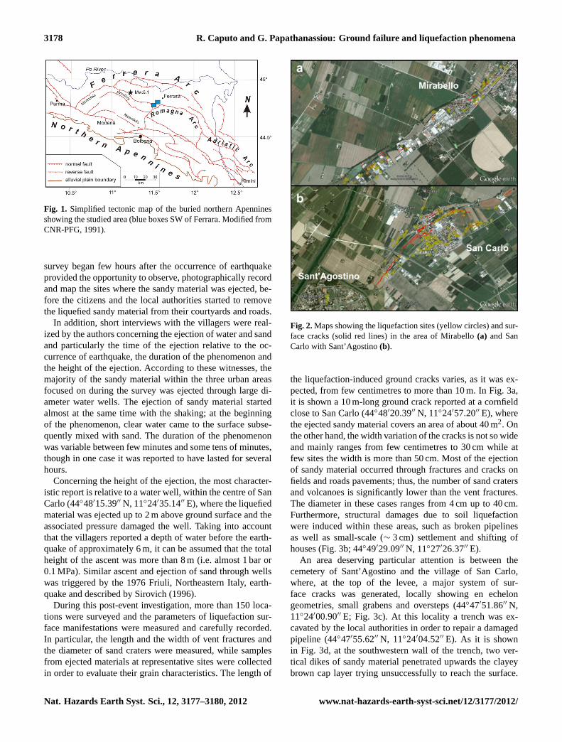
On the 20 May 2012 (04:03 local time), a strong earthquake(Mw = 6.1) with a focal mechanism showing E–W trend-ing, S-dipping reverse faulting occurred in the eastern sec-tor of the alluvial plain of the Po River close to the borderbetween Emilia-Romagna and Lombardy regions (NorthernItaly). The activated tectonic structure is completely blind,though it was well known from a dense grid of seismic pro-files for hydrocarbon explorations (Fig. 1; Pieri and Groppi,1981; Toscani et al., 2009), while its recent activity was sug-gested by drainage anomalies (Burrato et al., 2003; Basili etal., 2008; DISS WG, 2010). The event induced extensive ge-ological effects at the surface and structural damages in thebroader epicentral area, up to a distance of 20 km. Accordingto theIstituto Nazionale di Geofisica e Vulcanologia(INGV),
the hypocenter was located at 44.89◦ N, 11.23◦ E at a depthof 6.3 km.
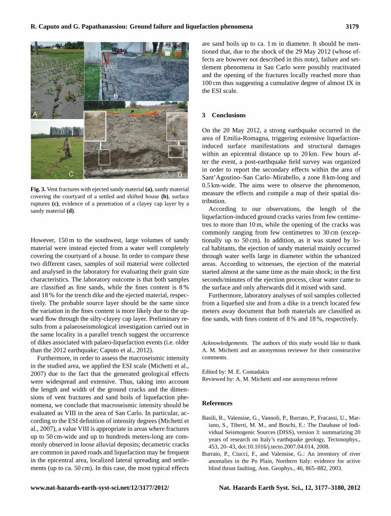
In this brief communication, we report and map groundfailures triggered by the earthquake within a zone 8 km-long and 0.5 km-wide mainly corresponding to an abandonedreach of the Reno River. The developed maps were sepa-rated in liquefaction manifestations and surface cracks, re-spectively, and reproduced on a Google (2012) base layer(Fig. 2). In addition, a preliminary evaluation of the macro-seismic intensity in the studied area is performed based onenvironmental seismic intensity scale (Michetti et al., 2007).
The villages in this area, Sant’Agostino, San Carlo andMirabello (WSW of Ferrara), were constructed upon a for-mer river channel and its related crevasse bodies and artifi-cial levees; they suffered severe damage due to both lateralspreading and liquefaction. Similar secondary effects, withinold and/or former river channel zones, were generated, forinstance, during the 1992 Roermond, Netherlands–Germany(Trifonov et al., 1994); 1990 Luzon, Philippines; 2007 Ni-igata Chuetsu-oki, Japan; and 2010 Darfield, New Zealandearthquakes (Wotherspoon et al., 2012), showing that thistype of morphological setting is favourable to earthquake-induced ground cracks and liquefaction phenomena.
2 Earthquake-induced ground deformations
Few hours after the event, a post-earthquake field survey wasorganized in order to report the secondary effects and to com-pile a map of their spatial distribution. The fact that this
Published by Copernicus Publications on behalf of the European Geosciences Union.
3178 R. Caputo and G. Papathanassiou: Ground failure and liquefaction phenomena
Fig. 1. Simplified tectonic map of the buried northern Apenninesshowing the studied area (blue boxes SW of Ferrara. Modified fromCNR-PFG, 1991).
survey began few hours after the occurrence of earthquakeprovided the opportunity to observe, photographically recordand map the sites where the sandy material was ejected, be-fore the citizens and the local authorities started to removethe liquefied sandy material from their courtyards and roads.
In addition, short interviews with the villagers were real-ized by the authors concerning the ejection of water and sandand particularly the time of the ejection relative to the oc-currence of earthquake, the duration of the phenomenon andthe height of the ejection. According to these witnesses, themajority of the sandy material within the three urban areasfocused on during the survey was ejected through large di-ameter water wells. The ejection of sandy material startedalmost at the same time with the shaking; at the beginningof the phenomenon, clear water came to the surface subse-quently mixed with sand. The duration of the phenomenonwas variable between few minutes and some tens of minutes,though in one case it was reported to have lasted for severalhours.
Concerning the height of the ejection, the most character-istic report is relative to a water well, within the centre of SanCarlo (44◦48′15.39′′ N, 11◦24′35.14′′ E), where the liquefiedmaterial was ejected up to 2 m above ground surface and theassociated pressure damaged the well. Taking into accountthat the villagers reported a depth of water before the earth-quake of approximately 6 m, it can be assumed that the totalheight of the ascent was more than 8 m (i.e. almost 1 bar or0.1 MPa). Similar ascent and ejection of sand through wellswas triggered by the 1976 Friuli, Northeastern Italy, earth-quake and described by Sirovich (1996).
During this post-event investigation, more than 150 loca-tions were surveyed and the parameters of liquefaction sur-face manifestations were measured and carefully recorded.In particular, the length and the width of vent fractures andthe diameter of sand craters were measured, while samplesfrom ejected materials at representative sites were collectedin order to evaluate their grain characteristics. The length of
Fig. 2.Maps showing the liquefaction sites (yellow circles) and sur-face cracks (solid red lines) in the area of Mirabello(a) and SanCarlo with Sant’Agostino(b).
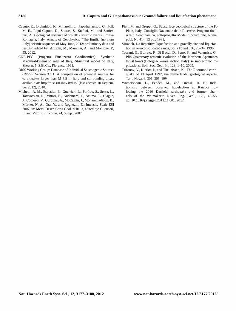
the liquefaction-induced ground cracks varies, as it was ex-pected, from few centimetres to more than 10 m. In Fig. 3a,it is shown a 10 m-long ground crack reported at a cornfieldclose to San Carlo (44◦48′20.39′′ N, 11◦24′57.20′′ E), wherethe ejected sandy material covers an area of about 40 m2. Onthe other hand, the width variation of the cracks is not so wideand mainly ranges from few centimetres to 30 cm while atfew sites the width is more than 50 cm. Most of the ejectionof sandy material occurred through fractures and cracks onfields and roads pavements; thus, the number of sand cratersand volcanoes is significantly lower than the vent fractures.The diameter in these cases ranges from 4 cm up to 40 cm.Furthermore, structural damages due to soil liquefactionwere induced within these areas, such as broken pipelinesas well as small-scale (∼ 3 cm) settlement and shifting ofhouses (Fig. 3b; 44◦49′29.09′′ N, 11◦27′26.37′′ E).
An area deserving particular attention is between thecemetery of Sant’Agostino and the village of San Carlo,where, at the top of the levee, a major system of sur-face cracks was generated, locally showing en echelongeometries, small grabens and oversteps (44◦47′51.86′′ N,11◦24′00.90′′ E; Fig. 3c). At this locality a trench was ex-cavated by the local authorities in order to repair a damagedpipeline (44◦47′55.62′′ N, 11◦24′04.52′′ E). As it is shownin Fig. 3d, at the southwestern wall of the trench, two ver-tical dikes of sandy material penetrated upwards the clayeybrown cap layer trying unsuccessfully to reach the surface.
Nat. Hazards Earth Syst. Sci., 12, 3177–3180, 2012 www.nat-hazards-earth-syst-sci.net/12/3177/2012/
R. Caputo and G. Papathanassiou: Ground failure and liquefaction phenomena 3179
Fig. 3.Vent fractures with ejected sandy material(a), sandy materialcovering the courtyard of a settled and shifted house(b), surfaceruptures(c), evidence of a penetration of a clayey cap layer by asandy material(d).
However, 150 m to the southwest, large volumes of sandymaterial were instead ejected from a water well completelycovering the courtyard of a house. In order to compare thesetwo different cases, samples of soil material were collectedand analysed in the laboratory for evaluating their grain sizecharacteristics. The laboratory outcome is that both samplesare classified as fine sands, while the fines content is 8 %and 18 % for the trench dike and the ejected material, respec-tively. The probable source layer should be the same sincethe variation in the fines content is more likely due to the up-ward flow through the silty-clayey cap layer. Preliminary re-sults from a palaeoseismological investigation carried out inthe same locality in a parallel trench suggest the occurrenceof dikes associated with palaeo-liquefaction events (i.e. olderthan the 2012 earthquake; Caputo et al., 2012).
Furthermore, in order to assess the macroseismic intensityin the studied area, we applied the ESI scale (Michetti et al.,2007) due to the fact that the generated geological effectswere widespread and extensive. Thus, taking into accountthe length and width of the ground cracks and the dimen-sions of vent fractures and sand boils of liquefaction phe-nomena, we conclude that macroseismic intensity should beevaluated as VIII in the area of San Carlo. In particular, ac-cording to the ESI definition of intensity degrees (Michetti etal., 2007), a value VIII is appropriate in areas where fracturesup to 50 cm-wide and up to hundreds meters-long are com-monly observed in loose alluvial deposits; decametric cracksare common in paved roads and liquefaction may be frequentin the epicentral area, localized lateral spreading and settle-ments (up to ca. 50 cm). In this case, the most typical effects
are sand boils up to ca. 1 m in diameter. It should be men-tioned that, due to the shock of the 29 May 2012 (whose ef-fects are however not described in this note), failure and set-tlement phenomena in San Carlo were possibly reactivatedand the opening of the fractures locally reached more than100 cm thus suggesting a cumulative degree of almost IX inthe ESI scale.
3 Conclusions
On the 20 May 2012, a strong earthquake occurred in thearea of Emilia-Romagna, triggering extensive liquefaction-induced surface manifestations and structural damageswithin an epicentral distance up to 20 km. Few hours af-ter the event, a post-earthquake field survey was organizedin order to report the secondary effects within the area ofSant’Agostino–San Carlo–Mirabello, a zone 8 km-long and0.5 km-wide. The aims were to observe the phenomenon,measure the effects and compile a map of their spatial dis-tribution.
According to our observations, the length of theliquefaction-induced ground cracks varies from few centime-tres to more than 10 m, while the opening of the cracks wascommonly ranging from few centimetres to 30 cm (excep-tionally up to 50 cm). In addition, as it was stated by lo-cal habitants, the ejection of sandy material mainly occurredthrough water wells large in diameter within the urbanizedareas. According to witnesses, the ejection of the materialstarted almost at the same time as the main shock; in the firstseconds/minutes of the ejection process, clear water came tothe surface and only afterwards did it mixed with sand.
Furthermore, laboratory analyses of soil samples collectedfrom a liquefied site and from a dike in a trench located fewmeters away document that both materials are classified asfine sands, with fines content of 8 % and 18 %, respectively.
Acknowledgements.The authors of this study would like to thankA. M. Michetti and an anonymous reviewer for their constructivecomments.
Edited by: M. E. ContadakisReviewed by: A. M. Michetti and one anonymous referee
References
Basili, R., Valensise, G., Vannoli, P., Burrato, P., Fracassi, U., Mar-iano, S., Tiberti, M. M., and Boschi, E.: The Database of Indi-vidual Seismogenic Sources (DISS), version 3: summarizing 20years of research on Italy’s earthquake geology, Tectonophys.,453, 20–43,doi:10.1016/j.tecto.2007.04.014, 2008.
Burrato, P., Ciucci, F., and Valensise, G.: An inventory of riveranomalies in the Po Plain, Northern Italy: evidence for activeblind thrust faulting, Ann. Geophys., 46, 865–882, 2003.
www.nat-hazards-earth-syst-sci.net/12/3177/2012/ Nat. Hazards Earth Syst. Sci., 12, 3177–3180, 2012
3180 R. Caputo and G. Papathanassiou: Ground failure and liquefaction phenomena
Caputo, R., Iordanidou, K., Minarelli, L., Papathanassiou, G., Poli,M. E., Rapti-Caputo, D., Sboras, S., Stefani, M., and Zanfer-rari, A.: Geological evidence of pre-2012 seismic events, Emilia-Romagna, Italy, Annals of Geophysics, “The Emilia (northernItaly) seismic sequence of May-June, 2012: preliminary data andresults” edited by: Anzidei, M., Maramai, A., and Montone, P.,55, 2012.
CNR-PFG (Progetto Finalizzato Geodinamica): Syntheticstructural-kinematic map of Italy, Structural model of Italy,Sheet n. 5. S.El.Ca., Florence, 1991.
DISS Working Group: Database of Individual Seismogenic Sources(DISS), Version 3.1.1: A compilation of potential sources forearthquakes larger than M 5.5 in Italy and surrounding areas,available at:http://diss.rm.ingv.it/diss/(last access: 10 Septem-ber 2012), 2010.
Michetti, A. M., Esposito, E., Guerrieri, L., Porfido, S., Serva, L.,Tatevossian, R., Vittori, E., Audemard, F., Azuma, T., Clague,J., Comerci, V., Gurpinar, A., McCalpin, J., Mohammadioun, B.,Morner, N. A., Ota, Y., and Roghozin, E.: Intensity Scale ESI2007, in: Mem. Descr. Carta Geol. d’Italia, edited by: Guerrieri,L. and Vittori, E., Rome, 74, 53 pp., 2007.
Pieri, M. and Groppi, G.: Subsurface geological structure of the PoPlain, Italy, Consiglio Nazionale delle Ricerche, Progetto final-izzato Geodinamica, sottoprogetto Modello Strutturale, Rome,publ. No 414, 13 pp., 1981.
Sirovich, L.: Repetitive liquefaction at a gravelly site and liquefac-tion in overconsolidated sands, Soils Found., 36, 23–34, 1996.
Toscani, G., Burrato, P., Di Bucci, D., Seno, S., and Valensise, G.:Plio-Quaternary tectonic evolution of the Northern Apenninesthrust fronts (Bologna-Ferrara section, Italy): seismotectonic im-plications, Boll. Soc. Geol. It., 128, 1–10, 2009.
Trifonov, V., Klerkx, J., and Theunissen, K.: The Roermond earth-quake of 13 April 1992, the Netherlands: geological aspects,Terra Nova, 6, 301–305, 1994.
Wotherspoon, L., Pender, M., and Orense, R. P.: Rela-tionship between observed liquefaction at Kaiapoi fol-lowing the 2010 Darfield earthquake and former chan-nels of the Waimakariri River, Eng. Geol., 125, 45–55,doi:10.1016/j.enggeo.2011.11.001, 2012.
Nat. Hazards Earth Syst. Sci., 12, 3177–3180, 2012 www.nat-hazards-earth-syst-sci.net/12/3177/2012/