Bridging the 11th Street Bridge Park - ULI Washington
48
Bridging the 11 th Street Bridge Park 2015-2016 ULI Regional Land Use Leadership Institute Mini Technical Assistance Panel Luke Davis | Gabriela Canamar Clark | Scott Rowe | Phil Hummel | Joanne Fiebe | Michael Brown | Radhika Mohan
Transcript of Bridging the 11th Street Bridge Park - ULI Washington
Bridging the 11th
Street Bridge Park2015-2016 ULI Regional Land Use Leadership Institute
Mini Technical Assistance Panel
Luke Davis | Gabriela Canamar Clark | Scott Rowe | Phil Hummel | Joanne Fiebe | Michael Brown | Radhika Mohan
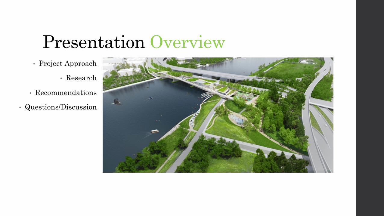
Presentation Overview• Project Approach
• Research
• Recommendations
• Questions/Discussion

Project ApproachHow can the 11th Street Bridge Park be accessible to pedestrians, cyclists, and to public transit? But how will people bridge to the park?
• Site Visit
• Background Research on Relevant Plans and
Projects
• Identifying Connections
• Recommendations & Regional Benefits
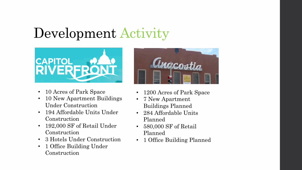
Development Activity
• 10 Acres of Park Space• 10 New Apartment Buildings
Under Construction• 194 Affordable Units Under
Construction• 192,000 SF of Retail Under
Construction• 3 Hotels Under Construction• 1 Office Building Under
Construction
• 1200 Acres of Park Space• 7 New Apartment
Buildings Planned• 284 Affordable Units
Planned• 580,000 SF of Retail
Planned• 1 Office Building Planned

MLK Gateway Site• Location: Intersection of Good Hope Road SE and MLK Jr. Ave SE; ½-mile
from Anacostia Metrorail Station
• Size: 18,600 SF
• Zoning: C-3-A (Major Business and Employment Centers, Medium Density); Permits a wide variety of retail, office, and residential uses; Maximum Cumulative Density of 4.0 FAR; Maximum Building Height of 65 feet
• Status: DMPED issued RFEI April 2015 and had three respondents; DMPED anticipates issuing RFP early May 2016, with submissions in late summer and final selection by end of the year
• Community Benefits:� Affordable housing
� Inclusionary Zoning Law: certain percentage of rental or for sale units available at 51% - 80% AMI),
� Disposition of District Land for Affordable Housing Law: certain percentage of rental units available at 0% - 30% AMI and 31% - 50% AMI; certain percentage of for sale units available at 31%-50% AMI and 51%-80% AMI
� First Source Employment hiring requirements: generally, at least 51% of all new hires must be DC residents
� Programs for Certified Business Enterprises: generally, at least 35% of the project’s adjusted budget must be subcontracted to CBEs
� Sustainability: compliance with Green Building Act of 2006
Contact Information:Aimee McHale, Project Manager, Office of the Deputy Mayor for Planning & Economic Development(202) [email protected]
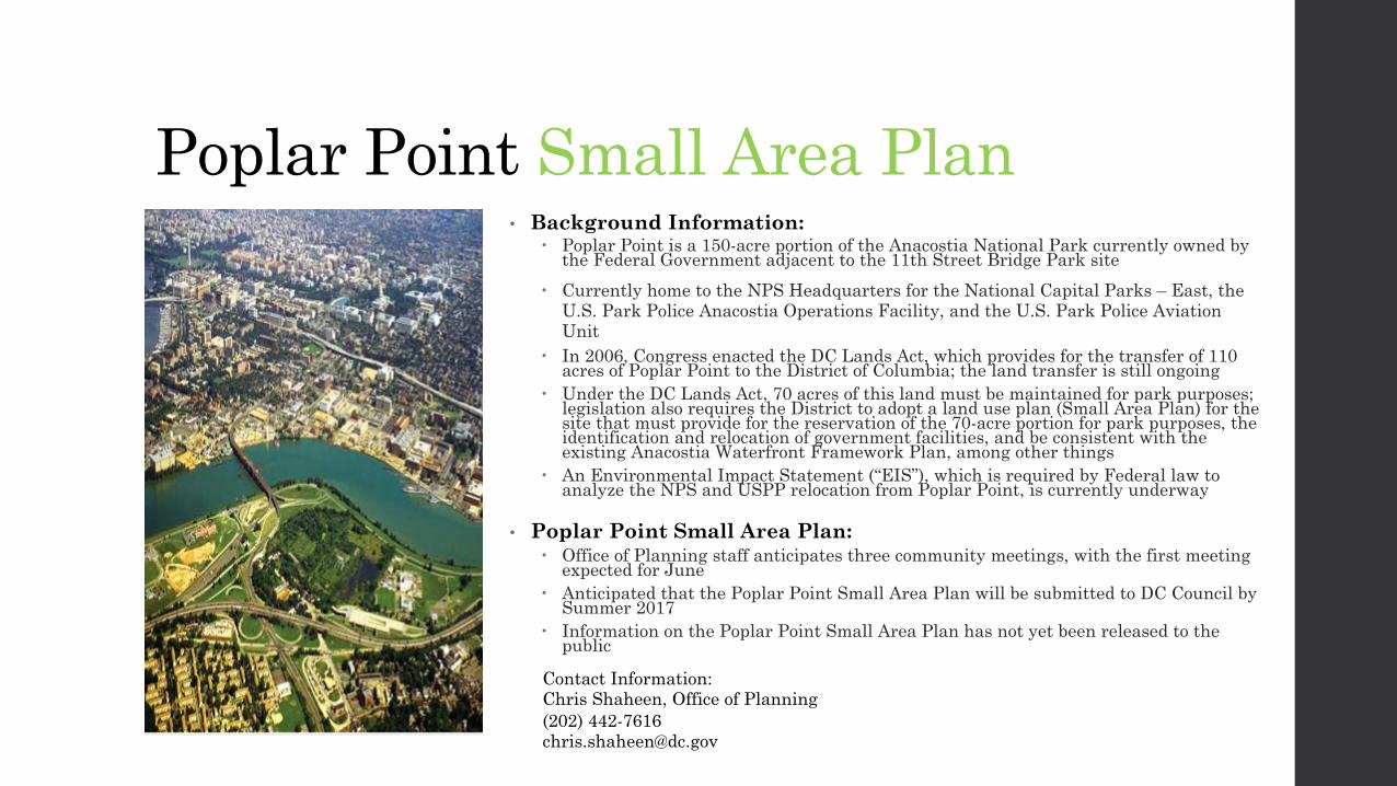
Poplar Point Small Area Plan• Background Information:
� Poplar Point is a 150-acre portion of the Anacostia National Park currently owned by the Federal Government adjacent to the 11th Street Bridge Park site
� Currently home to the NPS Headquarters for the National Capital Parks – East, the U.S. Park Police Anacostia Operations Facility, and the U.S. Park Police Aviation Unit
� In 2006, Congress enacted the DC Lands Act, which provides for the transfer of 110 acres of Poplar Point to the District of Columbia; the land transfer is still ongoing
� Under the DC Lands Act, 70 acres of this land must be maintained for park purposes; legislation also requires the District to adopt a land use plan (Small Area Plan) for the site that must provide for the reservation of the 70-acre portion for park purposes, the identification and relocation of government facilities, and be consistent with the existing Anacostia Waterfront Framework Plan, among other things
� An Environmental Impact Statement (“EIS”), which is required by Federal law to analyze the NPS and USPP relocation from Poplar Point, is currently underway
• Poplar Point Small Area Plan:� Office of Planning staff anticipates three community meetings, with the first meeting
expected for June� Anticipated that the Poplar Point Small Area Plan will be submitted to DC Council by
Summer 2017� Information on the Poplar Point Small Area Plan has not yet been released to the
public
Contact Information:Chris Shaheen, Office of Planning(202) [email protected]
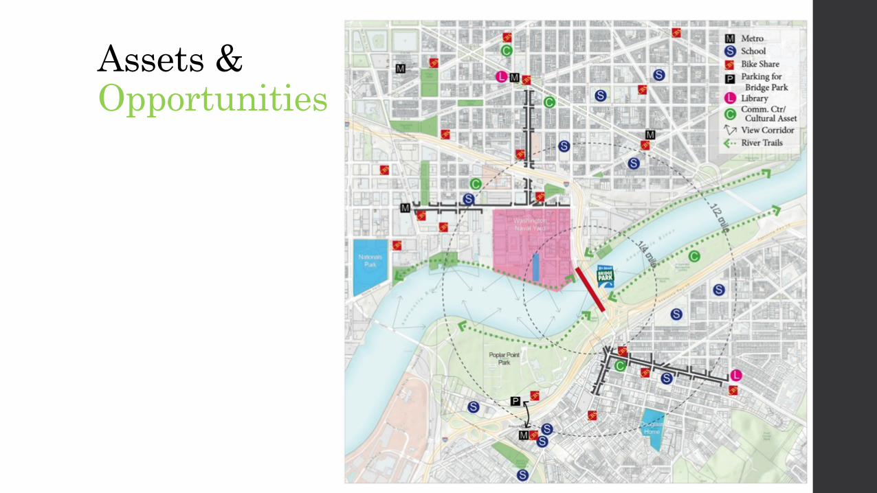
Assets & Opportunities
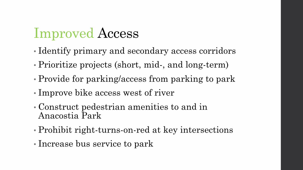
Improved Access• Identify primary and secondary access corridors• Prioritize projects (short, mid-, and long-term)• Provide for parking/access from parking to park• Improve bike access west of river• Construct pedestrian amenities to and in Anacostia Park• Prohibit right-turns-on-red at key intersections• Increase bus service to park

The Big MoveComplete Connections
• Enhance Anacostia River trails
• Construct high-quality walking and biking connections to key destinations in order to increase use of the bridge park and create economic development opportunities for local businesses

Bridging EastGood Hope Road SE/Anacostia Drive/ MLK Avenue SE
Race Street Underpass, PhiladelphiaPhoto Credit: DFX: Sound Vision
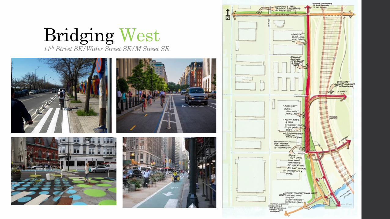
Bridging West11th Street SE/Water Street SE/M Street SE

• Possible aprons for table top transition
• Evaluate and improve trees and tree well plantings for “plaza” atmosphere
• Add accent pavement treatments for visual interest in speed control
• Delineate crosswalks• Triangle becomes part of
the plaza• Accent paving at
intersection to promote a pedestrian friendly environment
Off-Peak Hours Pedestrian/BikeUse only lane to enhance sense of arrival, allow for safer bicycle movements
11th St Bridge Parkaccess point
O Street
Navy Yard
N
Bridging West
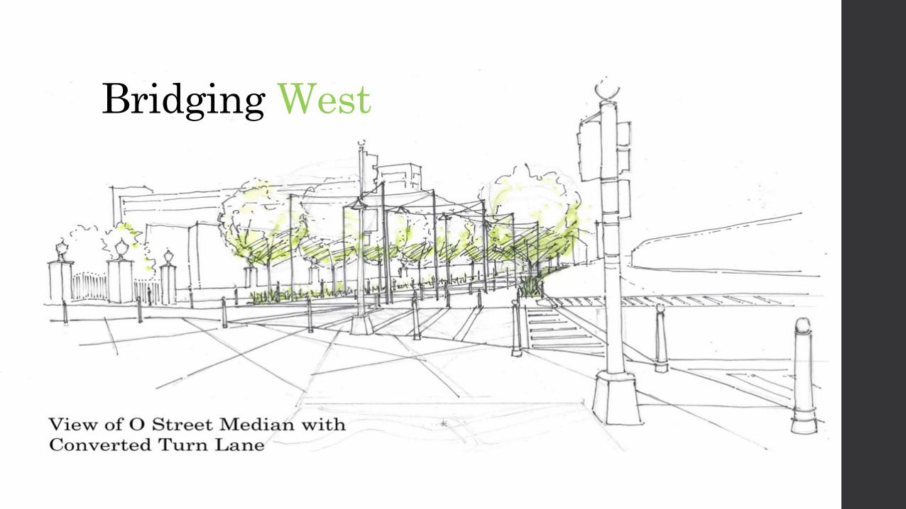
O Street
Navy Yard
Bridging West

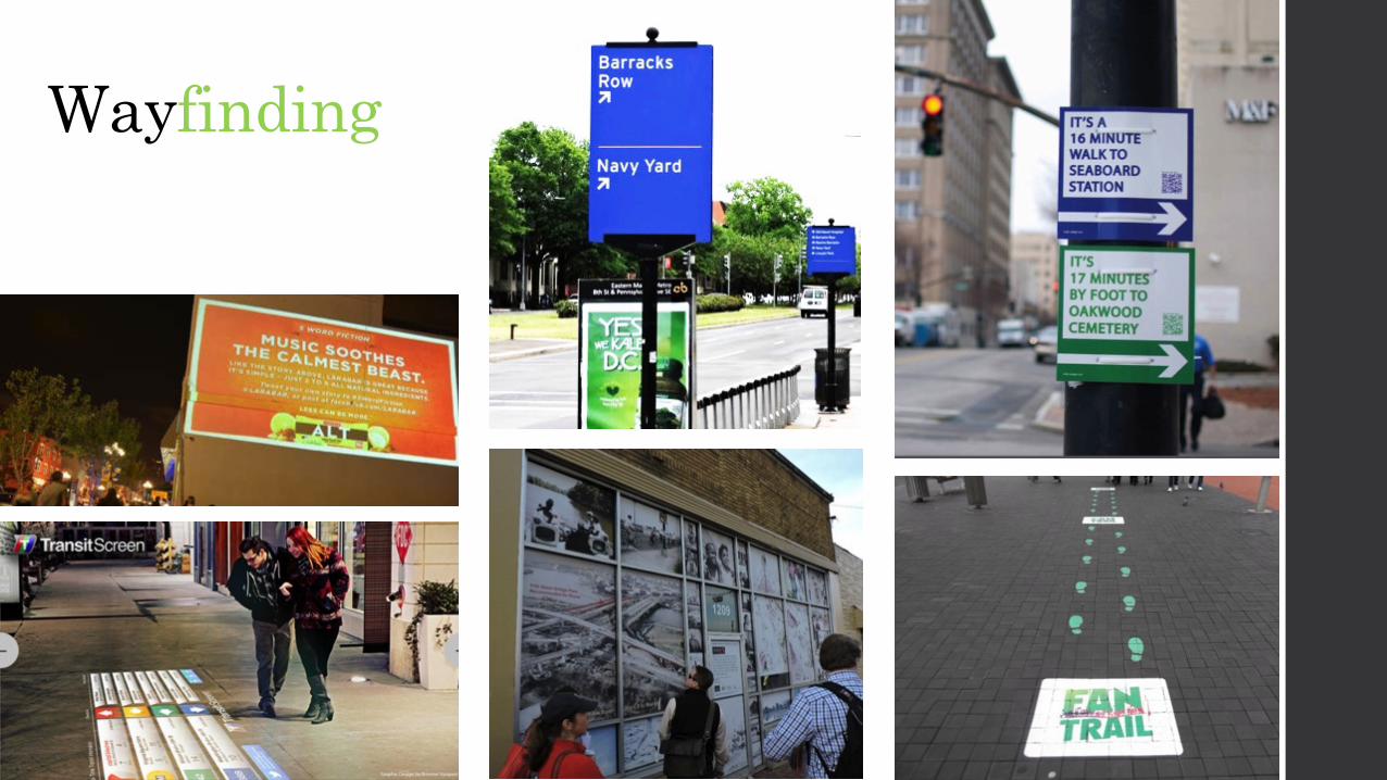
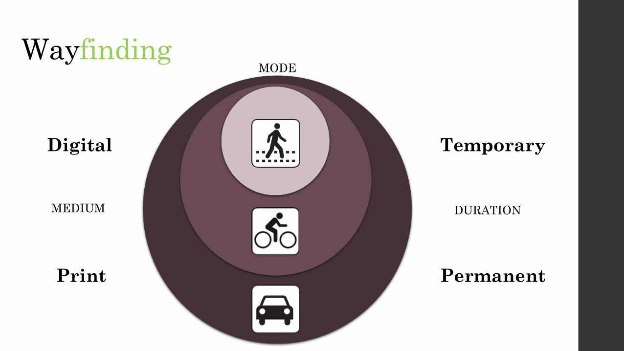
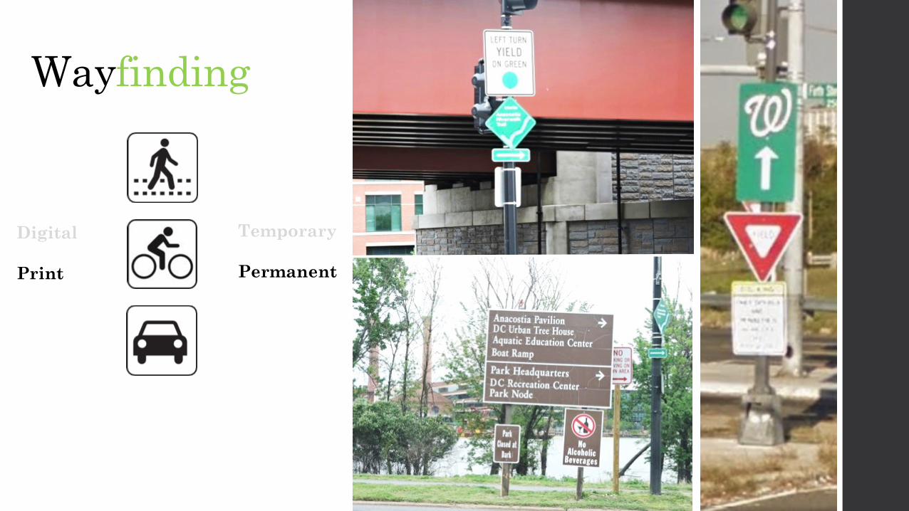
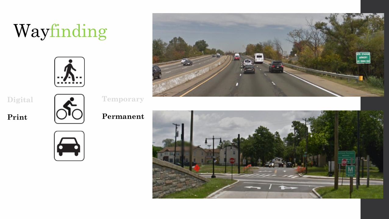
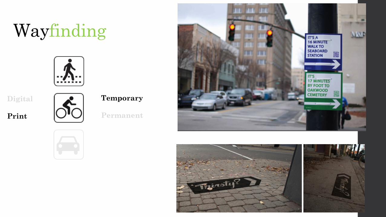
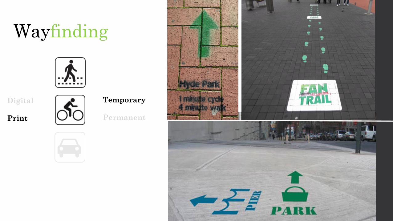
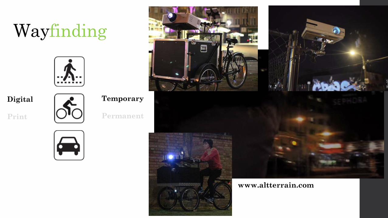
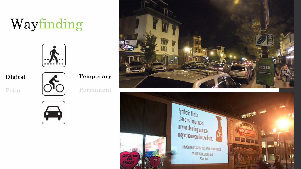
Wayfinding
Temporary
Permanent
Digital
MEDIUM DURATION
MODE
Wayfinding
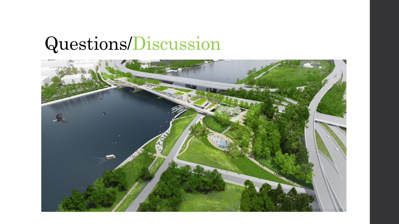
Questions/Discussion
Wayfinding
Temporary
Permanent
Digital
MEDIUM DURATION
MODE
Wayfinding
Digital
Temporary
Permanent

Wayfinding
Digital
Temporary
Permanent

Wayfinding
Digital
Temporary
Permanent
Wayfinding
Digital
Temporary
Permanent
Wayfinding
Digital
Temporary
Permanent
Wayfinding
Digital
Temporary
Permanent
Wayfinding
Digital
Temporary
Permanent
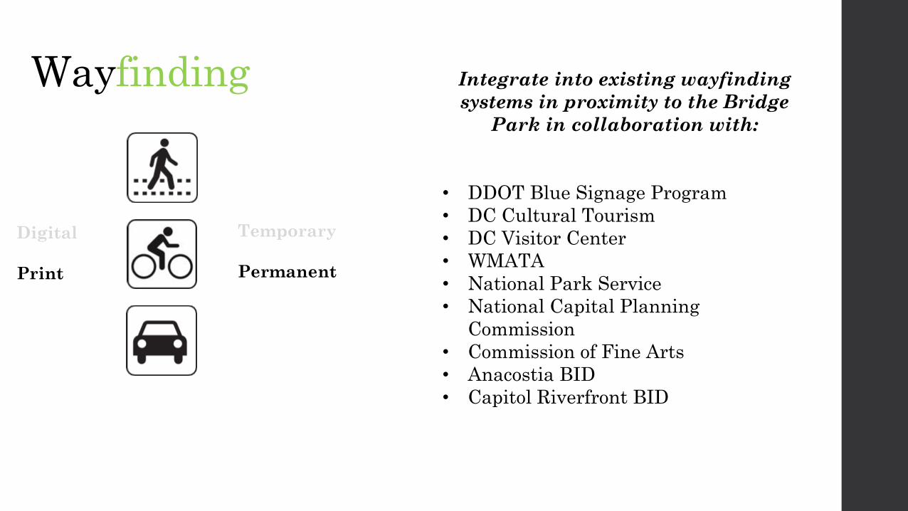
Integrate into existing wayfindingsystems in proximity to the Bridge
Park in collaboration with:
• DDOT Blue Signage Program• DC Cultural Tourism• DC Visitor Center• WMATA• National Park Service• National Capital Planning
Commission• Commission of Fine Arts• Anacostia BID• Capitol Riverfront BID

Wayfinding
Digital
Temporary
Permanent
Wayfinding
Digital
Temporary
Permanent
Wayfinding
Digital
Temporary
Permanent

Wayfinding
Digital
Temporary
Permanent
Wayfinding
Digital
Temporary
Permanent
www.altterrain.com
Digital
Temporary
Permanent
Wayfinding

Getting There
Digital
Temporary
Permanent
Digital
Temporary
Permanent
Wayfinding
Wayfinding
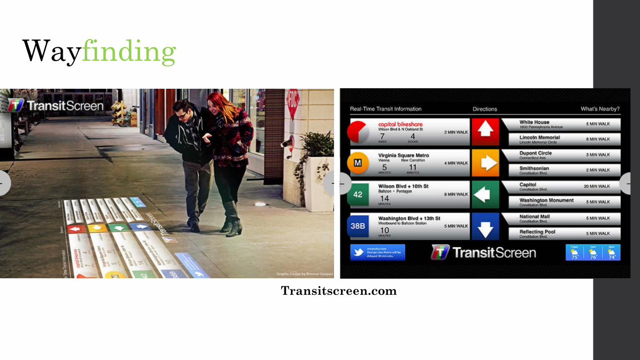
Transitscreen.com
Wayfinding
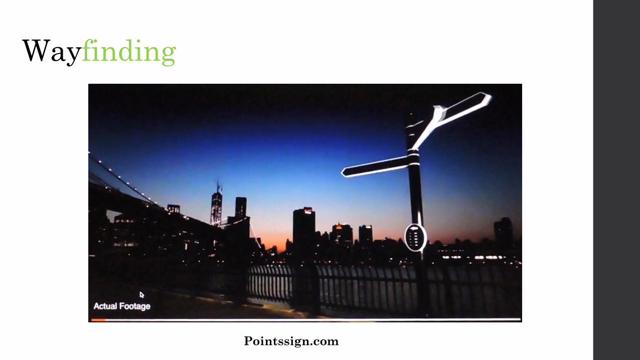
Pointssign.com
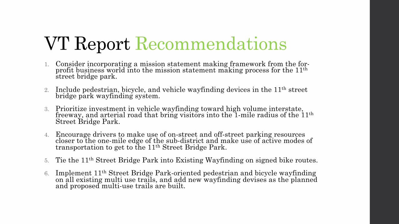
1. Consider incorporating a mission statement making framework from the for-profit business world into the mission statement making process for the 11thstreet bridge park.
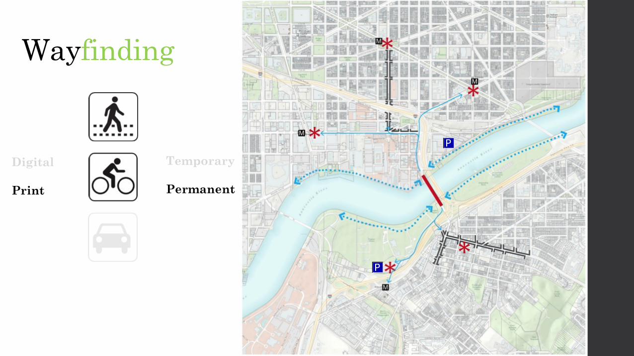
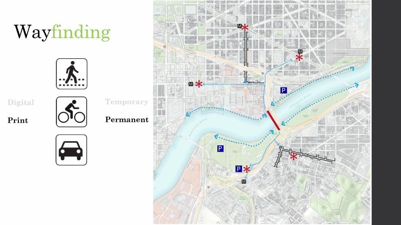
2. Include pedestrian, bicycle, and vehicle wayfinding devices in the 11th street bridge park wayfinding system.
3. Prioritize investment in vehicle wayfinding toward high volume interstate, freeway, and arterial road that bring visitors into the 1-mile radius of the 11th
Street Bridge Park.4. Encourage drivers to make use of on-street and off-street parking resources
closer to the one-mile edge of the sub-district and make use of active modes of transportation to get to the 11th Street Bridge Park.
5. Tie the 11th Street Bridge Park into Existing Wayfinding on signed bike routes.6. Implement 11th Street Bridge Park-oriented pedestrian and bicycle wayfinding
on all existing multi use trails, and add new wayfinding devises as the planned and proposed multi-use trails are built.
VT Report Recommendations
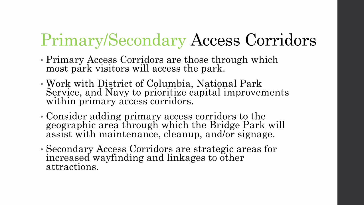
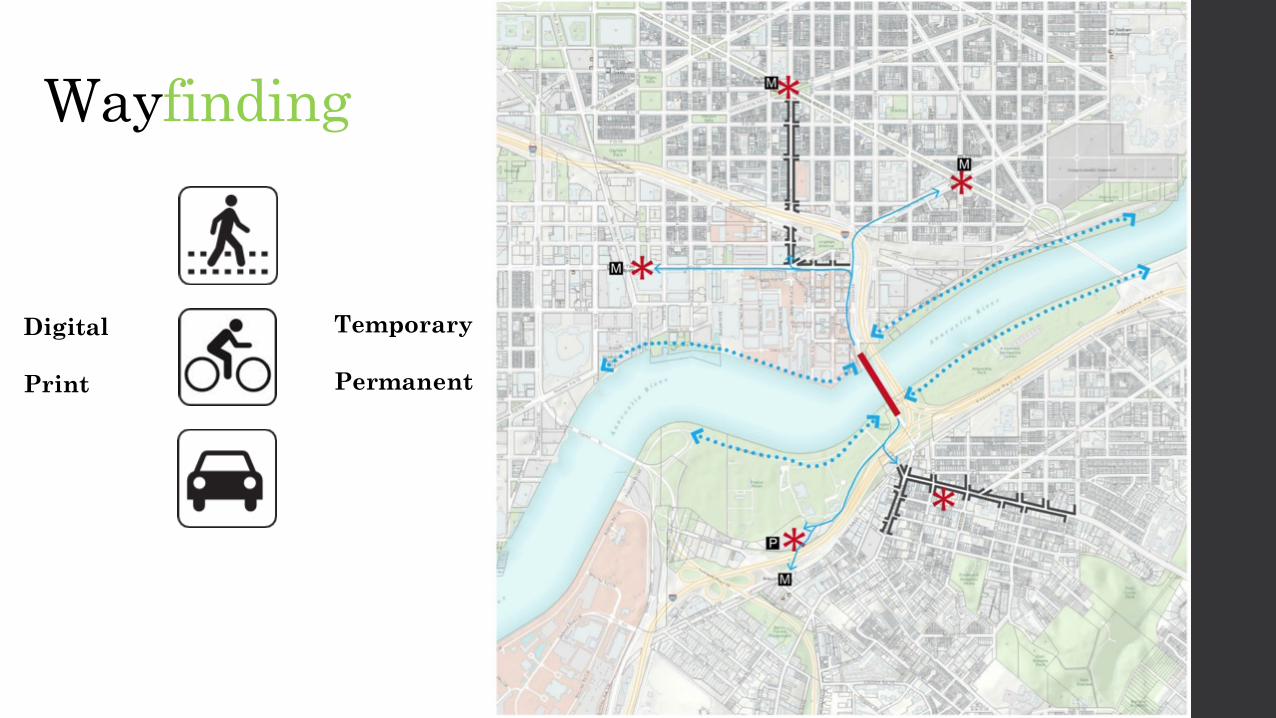
Primary/Secondary Access Corridors• Primary Access Corridors are those through which most park visitors will access the park. • Work with District of Columbia, National Park Service, and Navy to prioritize capital improvements within primary access corridors. • Consider adding primary access corridors to the geographic area through which the Bridge Park will assist with maintenance, cleanup, and/or signage. • Secondary Access Corridors are strategic areas for increased wayfinding and linkages to other attractions.
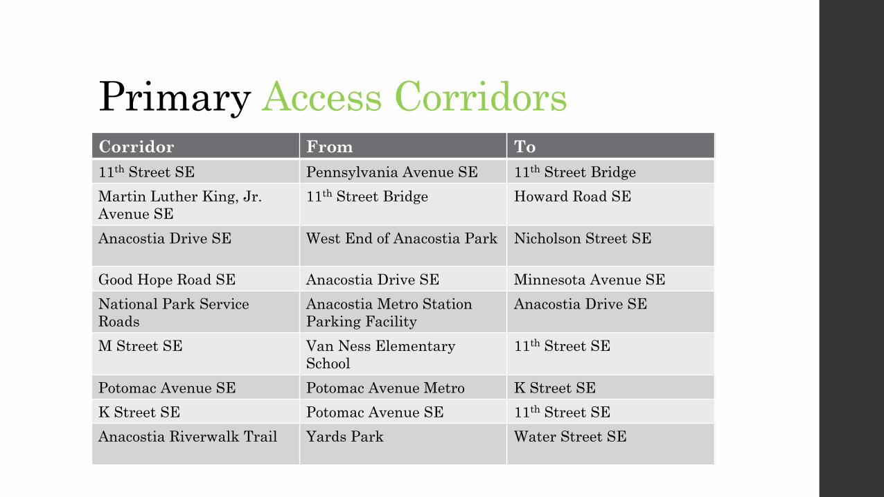
Primary Access CorridorsCorridor From To11th Street SE Pennsylvania Avenue SE 11th Street BridgeMartin Luther King, Jr. Avenue SE
11th Street Bridge Howard Road SE
Anacostia Drive SE West End of Anacostia Park Nicholson Street SE
Good Hope Road SE Anacostia Drive SE Minnesota Avenue SENational Park Service Roads
Anacostia Metro Station Parking Facility
Anacostia Drive SE
M Street SE Van Ness Elementary School
11th Street SE
Potomac Avenue SE Potomac Avenue Metro K Street SEK Street SE Potomac Avenue SE 11th Street SEAnacostia Riverwalk Trail Yards Park Water Street SE

Secondary Access CorridorsCorridor From ToMartin Luther King Jr. Avenue SE Howard Road SE Malcolm X Avenue SE
Suitland Parkway MD 4 Anacostia Drive SE
Anacostia Drive SE South Capitol Street SE Western terminus
Nicholson Street SE Minnesota Avenue SE Anacostia Drive SEI-295 I-95/495, National Harbor, MD
210DC 295
DC 295/Baltimore-Washington Parkway I-95/495 I-295
I-695 I-395 I-2958th Street SE Pennsylvania Avenue
SE/Eastern Market MetroM Street SE
Anacostia Riverwalk Trail Northern terminus 11th Street Bridge
14th Street SE Frederick Douglass NHS Good Hope Road SE
S Street SE Minnesota Ave SE Martin Luther King,Jr. Ave SE
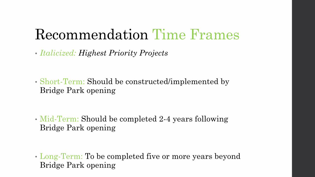
Recommendation Time Frames• Italicized: Highest Priority Projects
• Short-Term: Should be constructed/implemented by Bridge Park opening
• Mid-Term: Should be completed 2-4 years following Bridge Park opening
• Long-Term: To be completed five or more years beyond Bridge Park opening
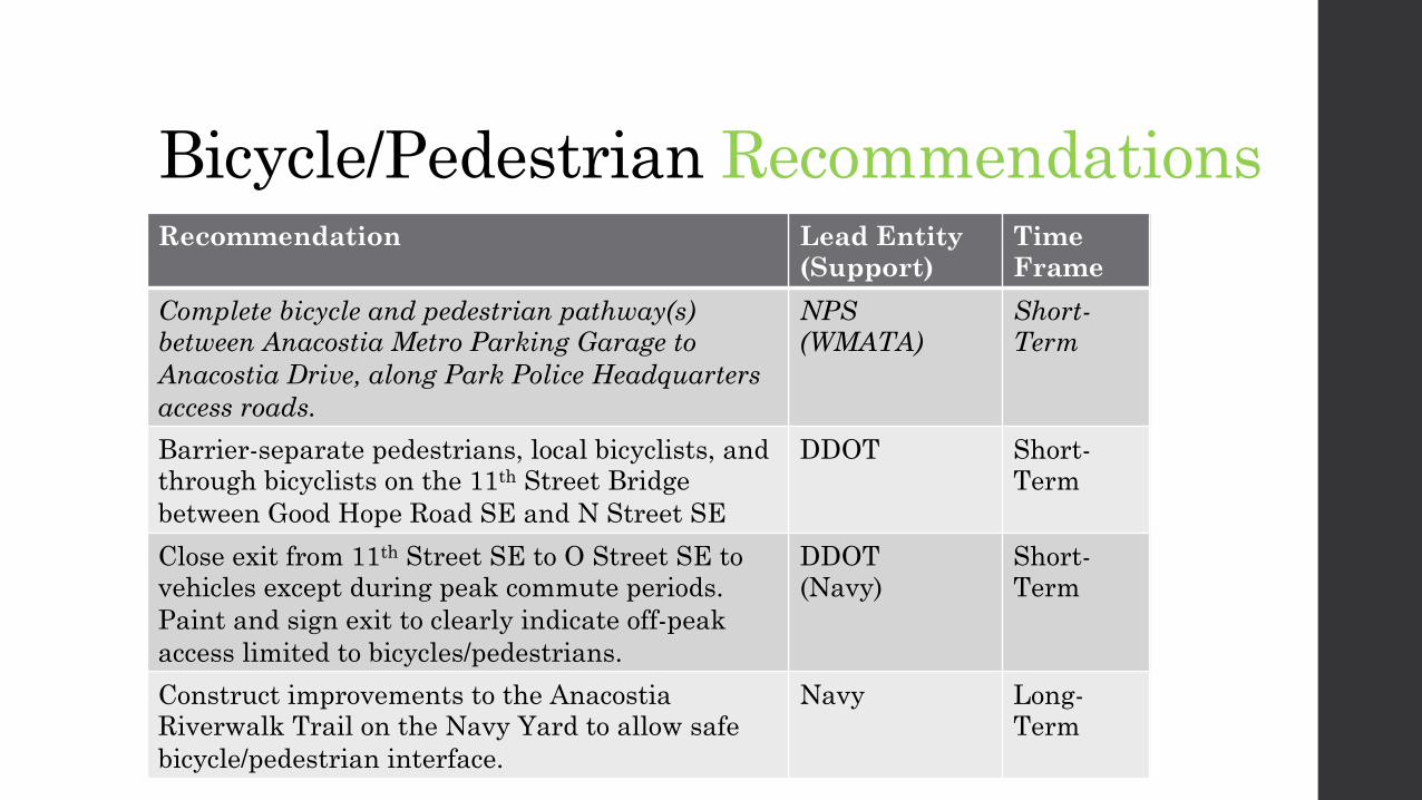
Bicycle/Pedestrian RecommendationsRecommendation Lead Entity
(Support)Time Frame
Complete bicycle and pedestrian pathway(s) between Anacostia Metro Parking Garage to Anacostia Drive, along Park Police Headquarters access roads.
NPS(WMATA)
Short-Term
Barrier-separate pedestrians, local bicyclists, and through bicyclists on the 11th Street Bridge between Good Hope Road SE and N Street SE
DDOT Short-Term
Close exit from 11th Street SE to O Street SE to vehicles except during peak commute periods. Paint and sign exit to clearly indicate off-peak access limited to bicycles/pedestrians.
DDOT(Navy)
Short-Term
Construct improvements to the Anacostia Riverwalk Trail on the Navy Yard to allow safe bicycle/pedestrian interface.
Navy Long-Term

Bicycle Access RecommendationsRecommendation Lead Entity
(Support)Time Frame
Create interim east-west bicycle route along L Street SE between 1st and 11th Streets SE
DDOT Short-Term
Create through and local bicycle facilities along Anacostia Drive to separate local/occasional bicyclists from through/commuter bicyclists
NPS Mid-Term
Provide Capital Bikeshare stations at both ends of the Bridge Park
Capital Bikeshare
Mid-Term
Connect eastern end of new Virginia Avenue Bike Trail with 11th Street SE Bike Lane
DDOT (CSX)
Mid-Term

Pedestrian Access RecommendationsRecommendation Lead
Entity (Support)
Time Frame
Upgrade interim pedestrian access/amenity requirements through construction zones
DDOT Short-Term
Retrofit sidewalks along Good Hope Road SE, W Street SE, and 14th Street SE for consistency with DDOT specifications for sidewalks within a Historic District.
DDOT Short-Term
Provide signalized pedestrian crossing of Howard Road SE at Anacostia Metro Station, to facilitate pedestrian access to Bridge Park via Martin Luther King, Jr. Avenue SE
DDOT(WMATA)
Short-Term
Improve sidewalk on north side of M Street SE between 5th Street SE and 11th Street SE up to Public Realm Manual Guidelines
DDOT Short-Term
Reconnect S Street SE between 14th Street SE and Martin Luther King, Jr. Ave SE
DDOT Long-Term
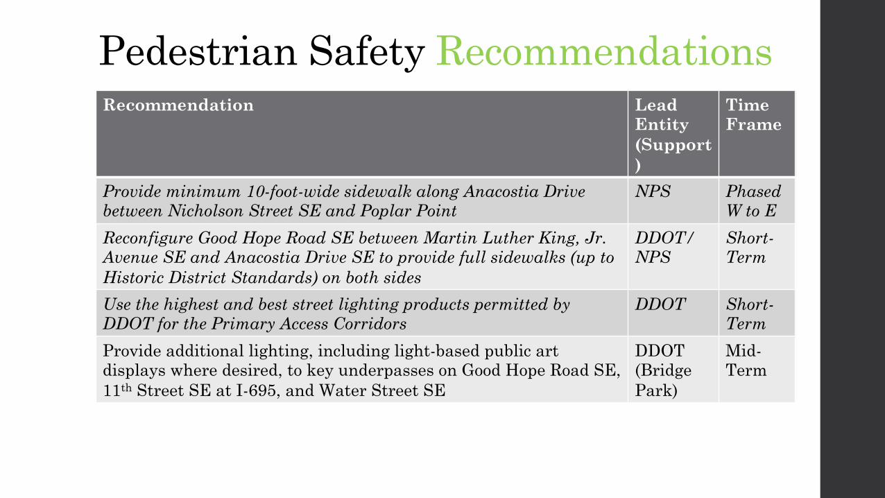
Pedestrian Safety RecommendationsRecommendation Lead
Entity (Support)
Time Frame
Provide minimum 10-foot-wide sidewalk along Anacostia Drive between Nicholson Street SE and Poplar Point
NPS PhasedW to E
Reconfigure Good Hope Road SE between Martin Luther King, Jr. Avenue SE and Anacostia Drive SE to provide full sidewalks (up to Historic District Standards) on both sides
DDOT/NPS
Short-Term
Use the highest and best street lighting products permitted by DDOT for the Primary Access Corridors
DDOT Short-Term
Provide additional lighting, including light-based public art displays where desired, to key underpasses on Good Hope Road SE, 11th Street SE at I-695, and Water Street SE
DDOT(Bridge Park)
Mid-Term

Pedestrian Safety Recommendations
• Prohibit right-turns-on-red at the following intersections: � Southbound Martin Luther King, Jr. Ave SE onto
northbound Good Hope Road SE� Northbound DC 295 Exit Ramp onto southbound Martin
Luther King, Jr. Ave SE� Southbound 11th Street SE onto southbound I-295� Eastbound Pennsylvania Avenue SE onto westbound
Potomac Avenue SE� All intersections along 11th Street SE from
Pennsylvania Avenue SE to Good Hope Road SE

Parking RecommendationsRecommendation Lead
Entity (Support)
Time Frame
Formalize parking agreements with private parking providers in the vicinity to provide interim parking options
BridgePark (Parking Owners)
Short-Term
Formalize agreement with WMATA for shared parking at Anacostia Metro parking facility
Bridge Park/WMATA
Short-Term
Provide accessible parking options at Bridge Park entrance NPS Short-Term
Construct shared parking facility at upriver end of Poplar Point TBD Long-Term

Transit RecommendationsRecommendation Lead Entity
(Support)Time Frame
Add a DC Circulator bus stop at 11th Street SE and O/Water Streets SE. Expand service on the Potomac Avenue Metro/Skyland route to Sundays
DDOT Short-Term
Provide additional bus stop amenities, including seating, shelters, NextBus information, wayfinding, and other information at the following locations: - 11th Street/Water Street/O Street- Martin Luther King, Jr. Ave SE/Good Hope
Road SE
DDOT(DMPED,Anacostia BID, Bridge Park)
Short-Term
Provide shuttle/Circulator service between the Eastern Avenue Metro and Anacostia Metro
DDOT Long-Term
Install docks beneath or adjacent to 11th Street Bridge to provide waterborne access
DDOT Long-Term
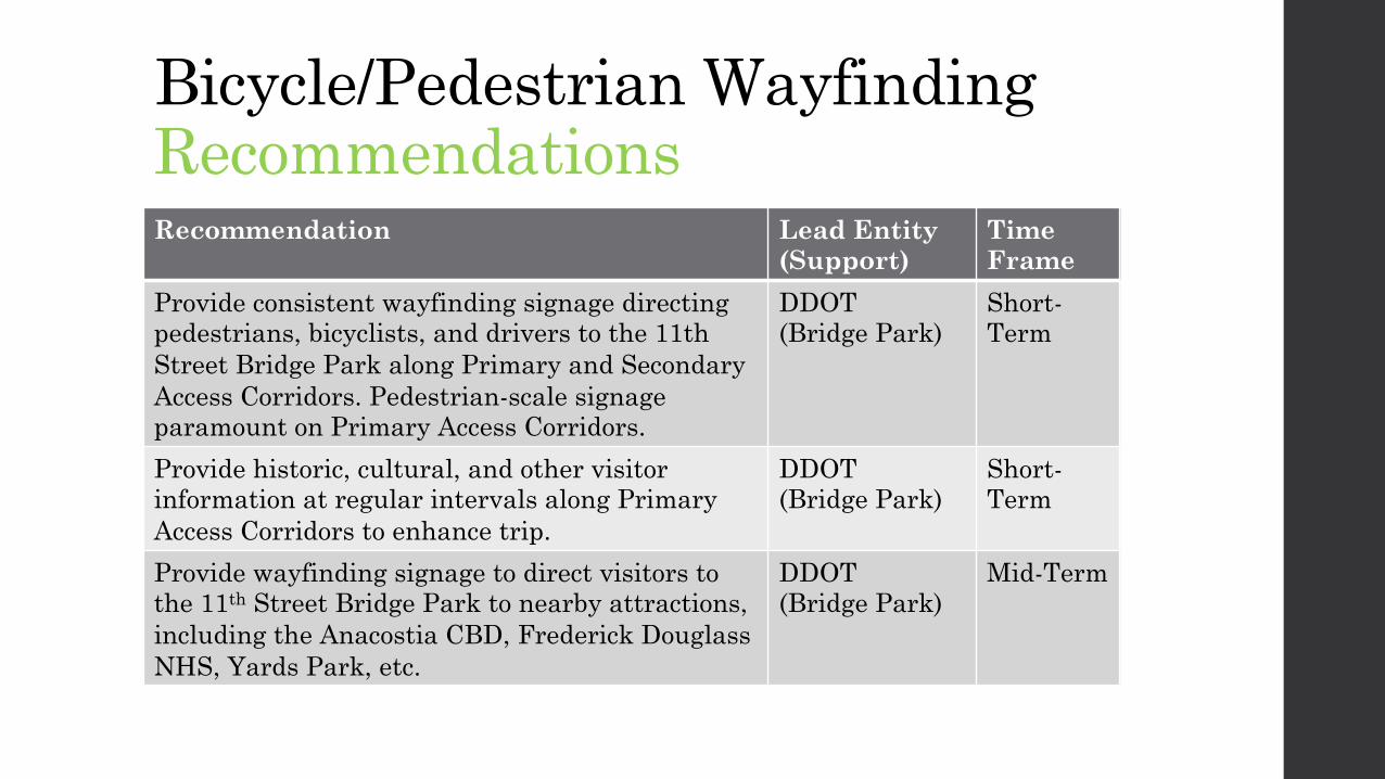
Bicycle/Pedestrian Wayfinding RecommendationsRecommendation Lead Entity
(Support)Time Frame
Provide consistent wayfinding signage directing pedestrians, bicyclists, and drivers to the 11th Street Bridge Park along Primary and Secondary Access Corridors. Pedestrian-scale signage paramount on Primary Access Corridors.
DDOT(Bridge Park)
Short-Term
Provide historic, cultural, and other visitorinformation at regular intervals along Primary Access Corridors to enhance trip.
DDOT(Bridge Park)
Short-Term
Provide wayfinding signage to direct visitors to the 11th Street Bridge Park to nearby attractions, including the Anacostia CBD, Frederick Douglass NHS, Yards Park, etc.
DDOT(Bridge Park)
Mid-Term

Vehicular Wayfinding RecommendationsRecommendation Lead Entity
(Support)Time Frame
Add highway-scale signage to direct drivers from westbound Suitland Parkway SE onto eastbound Howard Road SE to access parking for Bridge Park
DDOT Short Term
Through the use of standard MUTCD brown signage for attractions, add the 11th Street Bridge Park as a control destination on signage along I-295 for Exit 3B (South Capitol Street/Howard Road), including advance notification
DDOT Short Term