Bridge and Culvert Survey Ompompanoosuc River …...Bridge and Culvert Survey Ompompanoosuc River &...
18
Bridge and Culvert Survey Ompompanoosuc River & Major Tributaries Fairlee, Norwich, Thetford, Vershire, and West Fairlee, Vermont April 2007 Prepared by The Two Rivers-Ottauquechee Regional Commission Woodstock, Vermont
Transcript of Bridge and Culvert Survey Ompompanoosuc River …...Bridge and Culvert Survey Ompompanoosuc River &...

Bridge and Culvert Survey
Ompompanoosuc River &
Major Tributaries
Fairlee, Norwich, Thetford, Vershire, and West Fairlee, Vermont
April 2007
Prepared by The Two Rivers-Ottauquechee
Regional Commission Woodstock, Vermont
Table of Contents BRIDGE AND CULVERT ASSESSMENT....................................................................... 1
A. Methods............................................................................................................ 1 B. Results ............................................................................................................. 4
1. Category One Structures ........................................................... 4 A. Blocked Aquatic Organism Passage.......................................... 5 B. Proximity to Houses in Middle and Lower Watershed................ 5 2. Category Two Structures ........................................................... 6
C. Recommendations............................................................................................ 7 APPENDIX A................................................................................................................... 8

TRORC Ompompanoosuc Bridge & Culvert 2007
Page 1
BRIDGE AND CULVERT ASSESSMENT
A. Methods In sum, 31 bridges, 36 culverts, and 2 arches were included in the bridge and culvert assessment in five towns in the Two Rivers-Ottauquechee Region (see Appendix A). The geomorphic data from the bridge and culvert assessment were used to identify structures that have the potential to fail because of erosion, scour, or alignment problems, or structures that may have an impact on the stream. Sixty-three of the 69 structures surveyed were flagged on ANR’s Failure Modes Report for geomorphic incompatibility. One structure at the mouth of the Ompompanoosuc River at Vermont Route 5 was not assessed because of its size. The habitat data from the ANR bridge and culvert assessment were used to identify potential barriers to movement and migration of organism through culverts. The Wildlife Passage Report and the Culvert Aquatic Organism Passage Report from the assessment are provided in Appendix A. Nine of the 36 culverts assessed were identified as blocking aquatic organism passage, including adult salmonids, under flow conditions that existed at the time of the survey (fall, 2006).
Figure 1– Perched Outlet on Vershire Center Road
Culverts that are not properly installed, meaning those that are at or slightly below the stream’s grade, block aquatic organism passage. Organisms cannot pass through these culverts because of they cannot access the outlet and then they may not be able to travel up the bare culvert bottom. Erosion or scour can also occur if the structure was

TRORC Ompompanoosuc Bridge & Culvert 2007
Page 2
installed above grade because the water backs up at the inlet and cascades out at the outlet. Last, aggradation or sedimentation can occur upstream of the culvert, resulting in debris jams. Culverts that are properly installed at grade allow sediment and debris to pass through more readily than culverts installed above grade, resulting in less erosion and debris jams. Organisms can negotiate these culverts because of the gravel and cobble deposits that create a more natural bed inside the structure.
Figure 2 – Natural bed, at grade, Barker Brook in Thetford
In order to assist our five member towns with priorities for replacement of these structures, TRORC developed two priority lists using the information and photographs taken during the assessment. The bridge span and the culvert diameter as a percentage of the channel width were used as a first cut in prioritizing the structures for replacement. As shown in the Tables below, a total of 26 structures have a bankfull width of less than 50%.

TRORC Ompompanoosuc Bridge & Culvert 2007
Page 3
Figure 3 – Beaver Meadow Brook, approaching undersized culvert
Figure 4 – Inlet to culvert with 25% bankfull width on Beaver Meadow Brook
Bridges and culverts with channel widths of less than 40 percent of the bankfull width, which significantly impede natural sediment transport, or which block AOP, were placed in Category 1. Category 1 contains structures that have highest priority for replacement, primarily due to geomorphic incompatibility, erosion, scour, or alignment problems. The two photos above illustrate the nature of this problem. Structures with channel widths of between 40 and 49 percent of the bankfull width, which impede natural sediment transport or which block AOP, were placed in Category 2. Category 2 is of lower priority for replacement, but still contains structures that may be incompatible in terms of sediment transport.

TRORC Ompompanoosuc Bridge & Culvert 2007
Page 4
B. Results The Bridge and Culvert Assessment indicates that 27 of the public and private culverts within the survey area are undersized and represent some degree of risk for impeding sediment transport. Of these, 15 culverts were less than 40% of the bankfull width and 12 culverts had bankfull widths of 40 to 49 percent. The railroad trestle at the mouth of the Ompompanoosuc River at Vermont Route 5 was not assessed because of its size. It does not appear to be a barrier to organism passage nor sediment transport.
1. Category One Structures The Category 1 structures are summarized below in Table 1. All structures in this category are culverts and are top priorities for replacement because of their size.
Table 1 – Category 1 Structures Town Road Stream Name Structure Type Bankfull Width Percent
Fairlee Route 244 Blood Brook vtrans-
700028037909013 Culvert 23%
Thetford Barker Rd Barker Brook vtrans-
990021000909111 Culvert 35% H
Vershire Route 113 Eagle Hollow Brook dms-
200113000109052 Culvert 37% A
Vershire Fairbrothers Rd Beaver Meadow Brook vtrans-
700011021009143 Culvert 35%
Vershire Vershire Ctr Rd Upper Schoolhouse
Brook vtrans-
700003006709143 Culvert 38% A
Vershire Mero Rd Schoolhouse Brook Trib
(Mero) vtrans-
990036001009141 Culvert 32%
Vershire Mero Rd Mero Brook vtrans-
700036033209143 Culvert 30%
Vershire Ayers Rd Lower Schoolhouse
Brook vtrans-
990035000709141 Culvert 35% A
West Fairlee
Beaver Meadow Rd Beaver Meadow Brook
dms-100020000509161 Culvert 16% A, H
West Fairlee
Beaver Meadow Rd Beaver Meadow Brook
dms-100020000609161 Culvert 25%
West Fairlee Middlebrook Rd Middle Brook
vtrans-990002000409161 Culvert 37%
West Fairlee Middlebrook Rd Middle Brook
vtrans-990002000509161 Culvert 29% H
West Fairlee Marsh Hill Rd Blood Brook
vtrans-990024000709161 Culvert 33% A
West Fairlee
Beaver Meadow Rd Beaver Meadow Brook
vtrans-990020001009161 Culvert 30% H
West
Fairlee Beaver
Meadow Rd Beaver Meadow Brook vtrans-
990020000609161 Culvert 33% A Culvert blocks aquatic organism passage of all fish and stream salamanders including adult salmonids. H Culvert is near houses and other infrastructure, lower in the watershed.

TRORC Ompompanoosuc Bridge & Culvert 2007
Page 5
Figure 5 – Double culvert on Barker Brook, Thetford, with midchannel bar
This culvert on Barker Brook in Thetford is 35% of the bankfull width. This culvert is impeding the natural movement of sediment. The mid-channel bar immediately upstream of the inlet illustrates that deposition is occurring.
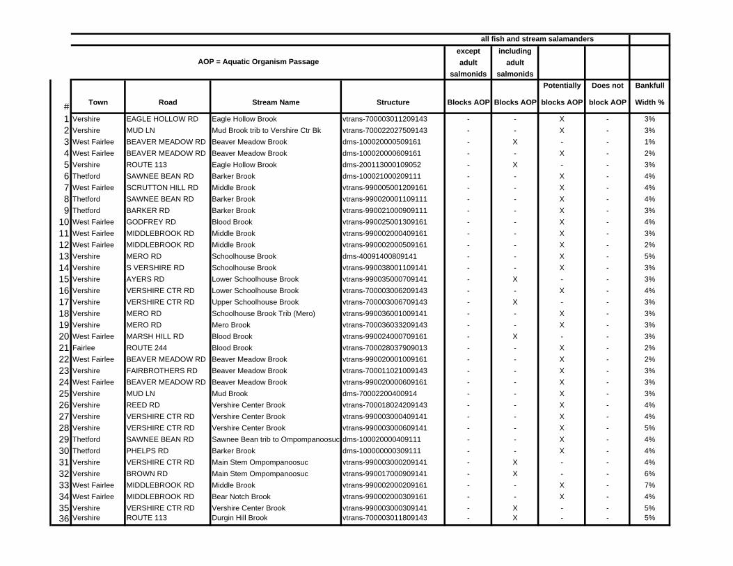
A. Blocked Aquatic Organism Passage Five of the culverts that have been included as Category 1 structures were identified as blocking aquatic organism passage under flow conditions found at the time of the assessment. The following conditions must be met at the time of the assessment for a culvert to be considered to block AOP of all fish (including adult salmonids) and stream salamanders:
• The culvert outlet configuration is free fall and the invert to the water surface distance is greater than or equal to 1.0 foot; or
• The water depth in the culvert at the outlet is less than 0.3 feet.
B. Proximity to Houses in Middle and Lower Watershed Four of the culverts that have been included as Category 1 structures were identified as high priorities for replacement because of their proximity to homes and road infrastructure. These culverts are located in the middle and lower sections of the

TRORC Ompompanoosuc Bridge & Culvert 2007
Page 6
watershed, and because they are undersized, pose the highest risk for becoming blocked and damaging or washing out homes and the roads that serve them.
2. Category Two Structures The Category 2 structures are summarized below in Table 2. As in Category 1, all structures in this category are culverts. Category 2 structures do not necessarily need replacement, but they should be monitored for significant upstream sediment deposition, upstream and downstream scour and erosion. Debris should be removed after the spring runoff and before the winter as well as after major storm events since these structures have smaller capacity to handle runoff with lower percentage of bankfull widths. They should be prioritized for replacement based on their condition and the amount of erosion, sedimentation, and debris jams they typically experience as well as their position on the reach and in the watershed.
Table 2 – Category Two Structures
Town Road Stream Name Structure Type Bankfull Width Percent
Thetford Sawnee Bean Rd Barker Brook
dms-100021000209111 Culvert 43%
Thetford Phelps Rd Barker Brook dms-100000000309111 Culvert 45%
Vershire Vershire Ctr Rd Main Stem Ompompanoosuc
vtrans-990003000209141 Culvert 47% *
Vershire Mud Ln Mud Brook dms-70002200400914 Culvert 42%
Vershire Vershire Ctr Rd Vershire Center Brook
vtrans-990003000409141 Culvert 42%
Vershire Vershire Ctr Rd
Lower Schoolhouse Brook
vtrans-700003006209143 Culvert 45%
Vershire Eagle Hollow Rd Eagle Hollow Brook
vtrans-700003011209143 Culvert 42%
Vershire Mud Ln Mud Brook trib to Vershire Ctr Bk
vtrans-700022027509143 Culvert 42%
Vershire S Vershire Rd Schoolhouse Brook
vtrans-990038001109141 Culvert 40%
West Fairlee Godfrey Rd Blood Brook
vtrans-990025001309161 Culvert 43%
West Fairlee Scrutton Hill Rd Middle Brook
vtrans-990005001209161 Culvert 48%
West Fairlee Middlebrook Rd Bear Notch Brook
vtrans-990002000309161 Culvert 49%
* Culvert blocks aquatic organism passage of all fish and stream salamanders including adult salmonids.

TRORC Ompompanoosuc Bridge & Culvert 2007
Page 7
C. Recommendations The Two Rivers-Ottauquechee Regional Commission is working with several towns on an infrastructure capital planning process. There are two parameters, percentage of bankfull width and if the structure has a perched outlet, allowing the structure to be flagged as geomorphically sensitive and included in a town’s replacement prioritization process. The Vermont Fish and Wildlife Department and the Agency of Natural Resources are in the process of preparing a publication for the design and construction of stream crossings that will be available for public review when complete. The Two Rivers-Ottauquechee Regional Commission recommends that the towns in this survey area acquire this design publication when available and work with the Agency of Natural Resources to provide stream crossings that offer geomorphic compatibility and passage for aquatic organisms and wildlife.

TRORC Ompompanoosuc Bridge & Culvert 2007
Page 8
APPENDIX A

F1 P1F2 P2F3 P3F4 P4F5 P5F6 P6
P7Width
# Town Road Stream Name Structure Type F1 F2 F3 F4 F5 F6 P1 P2 P3 P4 P5 P6 P7 Width1 Fairlee ROUTE 244 Blood Brook vtrans-700028037909013 Culvert - X - X X - - - - - - - X 2%2 Norwich ROUTE 132 Ompompanoosuc vtrans-700068032514113 Bridge - - - X - X - - - - X - X 218%3 Norwich ROUTE 132 Ompompanoosuc vtrans-700003012114113 Bridge - - - X - X - - - - X - X 210%4 Norwich ROUTE 5 N Ompompanoosuc vtrans-700068032414113 Bridge - - - X - - - - - - - - X 215%5 Norwich ROUTE 132 Ompompanoosuc vtrans-700068032314113 Bridge - - - X - - - - - - - - X 85%6 Norwich Railroad Trestle --- dms-7000RR000109102 Bridge MD MD MD MD MD MD MD MD MD MD MD MD MD --- %7 Thetford ACADEMY RD Ompompanoosuc vtrans-700003010914113 Bridge - - - X - - - - - - - - X 120%8 Thetford SAWNEE BEAN RD Barker Brook vtrans-990020001109111 Culvert - X X X X - X - - - - - X 4%9 Thetford BARKER RD Barker Brook vtrans-990021000909111 Culvert - X X X X X X - - X - - X 3%
10 Thetford SAWNEE BEAN RD Ompompanoosuc dms-100020000409111 Culvert - X X X X X X X - - - - X 4%11 Thetford SAWNEE BEAN RD Barker Brook dms-100021000209111 Culvert - X X X - X - X X - - - X 4%12 Thetford ROUTE 113 Ompompanoosuc vtrans-700003011014113 Bridge - - - - - - - - - - - - - 107%13 Thetford SAWNEE BEAN RD Ompompanoosuc vtrans-700001007414113 Bridge - - - - - - - - - - - - - 124%14 Thetford TUCKER HILL RD Ompompanoosuc vtrans-700001007314113 Bridge - - - X - X - - - X - - X 163%15 Thetford PHELPS RD Barker Brook dms-100000000309111 Culvert - X X X X - X - X - - - X 4%16 Thetford ROUTE 244 Ompompanoosuc vtrans-700008013114113 Bridge X - - X - X X - - - - - X 293%17 Vershire ROUTE 113 Ompompanoosuc dms-700000000109143 Bridge - X - X - X X - - X - - - 99%18 Vershire VERSHIRE CTR RD Vershire Center Brook vtrans-990003000309141 Culvert - X X X X X X - X X X - X 5%19 Vershire DURGIN HILL RD Durgin Hill Brook vtrans-700006017009143 Bridge - X X X - X X - X - - - X 50%20 Vershire ROUTE 113 Durgin Hill Brook vtrans-700003011809143 Culvert - X X X X X - X X X X - X 5%21 Vershire ROUTE 113 Eagle Hollow Brook dms-200113000109052 Culvert - X X X X X X X X X - - X 3%22 Vershire ROUTE 113 Ompompanoosuc vtrans-700003010609143 Bridge - - - - - - - - - - - - X 170%23 Vershire ROUTE 113 Ompompanoosuc vtrans-700027030009143 Bridge - - - - - - - - - - - - - 140%24 Vershire ROUTE 113 Ompompanoosuc vtrans-700027029709143 Bridge - - - X - - X - - - - - X 96%25 Vershire ROUTE 113 Ompompanoosuc vtrans-700000002409053 Bridge - - - - - - - - - - - - X 83%26 Vershire FAIRBROTHERS RD Beaver Meadow Brook vtrans-700011021009143 Culvert - X X X - X - - - - - - X 3%27 Vershire ROUTE 113 Ompompanoosuc vtrans-700009019709143 Bridge - - X - - - - X - - - - - 124%28 Vershire ROUTE 113 BEAVER MEADOW RD TRIB vtrans-700000002309053 Arch - - - - - - - - - - - - X 89%29 Vershire VERSHIRE CTR RD Main Stem Ompompanoosuc vtrans-990003000209141 Culvert - X X X - X X - X X - - - 4%30 Vershire BROWN RD Ompompanoosuc vtrans-990017000909141 Culvert - X X X X - - - X - - - X 6%31 Vershire RICKER BRIDGE RD Ompompanoosuc vtrans-700003010709143 Bridge - X - X - - - - - - X - X 90%32 Vershire MUD LN Mud Brook dms-70002200400914 Culvert - X X X - X - - X X X - - 3%
Concern for structure due to fluvial condition or processPotential failure due to out-flanking
Potential failure due to ice or debris jamStructure related damage due to flooding of adjacent propertyStructure related damage due to erosion of adjacent property
Structure width divided by channel width as a percent (% bankfull width)
Failure Modes
Poor location or alignmentBeaver activityFloodplain filled entirely or partially by roadway approaches
Existing ProblemsUpstream sediment depositUpstream Scour and/or erosion presentDownstream Scour and/or erosion presentInlet obstruction present
Potential failure due to scour

F1 P1F2 P2F3 P3F4 P4F5 P5F6 P6
P7Width
Concern for structure due to fluvial condition or processPotential failure due to out-flanking
Potential failure due to ice or debris jamStructure related damage due to flooding of adjacent propertyStructure related damage due to erosion of adjacent property
Structure width divided by channel width as a percent (% bankfull width)
Failure Modes
Poor location or alignmentBeaver activityFloodplain filled entirely or partially by roadway approaches
Existing ProblemsUpstream sediment depositUpstream Scour and/or erosion presentDownstream Scour and/or erosion presentInlet obstruction present
Potential failure due to scour
33 Vershire REED RD Vershire Center Brook vtrans-700018024209143 Culvert - X X X X X X - - X - - X 4%34 Vershire VERSHIRE CTR RD Vershire Center Brook vtrans-990003000409141 Culvert - X X X X X X X X X X - X 4%35 Vershire VERSHIRE CTR RD Vershire Center Brook vtrans-990003000609141 Culvert - X X X - X X - X - X - X 5%36 Vershire VERSHIRE CTR RD Vershire Center Brook vtrans-700113036109143 Bridge - - - X - X X - - X X - X 313%37 Vershire VERSHIRE CTR RD Lower Schoolhouse Brook vtrans-700003006209143 Culvert - X X X - X - - X - - - X 4%38 Vershire VERSHIRE CTR RD Upper Schoolhouse Brook vtrans-700003006709143 Culvert - X X X - X X - X - - - - 3%39 Vershire MERO RD Schoolhouse Brook Trib (Mero) vtrans-990036001009141 Culvert - X X X - X X X X - X - X 3%40 Vershire MERO RD Mero Brook vtrans-700036033209143 Culvert - X X X X X X - - X X - X 3%41 Vershire EAGLE HOLLOW RD Eagle Hollow Brook vtrans-700003011209143 Culvert - X - X - - - - - - - - - 3%42 Vershire MUD LN Bk vtrans-700022027509143 Culvert - X X X - X - - X X X - - 3%43 Vershire S VERSHIRE RD Schoolhouse Brook vtrans-700002005009143 Bridge X - - - - X X - - - X - - 100%44 Vershire MERO RD Schoolhouse Brook dms-40091400809141 Culvert - X X X X X X - - - - - X 5%45 Vershire S VERSHIRE RD Schoolhouse Brook vtrans-700038035309143 Bridge - X X X - X X - X - X - X 60%46 Vershire S VERSHIRE RD Schoolhouse Brook vtrans-990038001109141 Culvert - X X X X X X X X X X - X 3%47 Vershire AYERS RD Lower Schoolhouse Brook vtrans-990035000709141 Culvert - X X X X X X - X - - - X 3%48 West Fairlee BEAR NOTCH RD Bear Notch Brook vtrans-990017001109161 Bridge - X - X - X - - - - X - X 92%49 West Fairlee BEAVER MEADOW RD Beaver Meadow Brook dms-100020000509161 Culvert - X X X X X - - X X X - X 1%50 West Fairlee BEAVER MEADOW RD Beaver Meadow Brook dms-100020000609161 Culvert - X X X - X - X - - - - - 2%51 West Fairlee GODFREY RD Blood Brook vtrans-990025001309161 Culvert - X X X X - X - X - - - X 4%52 West Fairlee WILD HILL RD Wild Hill Brook vtrans-990002000109161 Bridge - X X X X X X X - - X - X 54%53 West Fairlee MIDDLEBROOK RD Middle Brook vtrans-990002000409161 Culvert - X - X X - - - - - - X X 3%54 West Fairlee MIDDLEBROOK RD Middle Brook vtrans-990002000509161 Culvert - X X X X - - - X - X - X 2%55 West Fairlee ROUTE 244 Middle Brook vtrans-990040000809111 Bridge - X - X X - - - - - - - X 73%56 West Fairlee BEANVILLE RD Schoolhouse Brook vtrans-700002005109143 Arch - X X X X - X - - - X - X 67%57 West Fairlee MARSH HILL RD Blood Brook vtrans-990024000709161 Culvert - X X X - X - - X - X - X 3%58 West Fairlee KING HILL RD Blood Brook vtrans-990026001409161 Bridge - X X X - X - X X - - - X 53%59 West Fairlee SCRUTTON HILL RD Middle Brook vtrans-990005001209161 Culvert - X X X - X X - - X - - - 4%60 West Fairlee MARSH HILL RD Middle Brook vtrans-990024000809161 Bridge - X X X - - X - - - - - X 68%61 West Fairlee BEAVER MEADOW RD Beaver Meadow Brook vtrans-990020001009161 Culvert - X X X - - X - - - - - - 2%62 West Fairlee BEAVER MEADOW RD Beaver Meadow Brook vtrans-990020000909161 Bridge - X - X - X X - X - X - - 87%63 West Fairlee CROSSROAD Ompompanoosuc vtrans-700011020209143 Bridge - - X - - X - X X - X - X 157%64 West Fairlee BACK ST Schoolhouse Brook vtrans-700003013709053 Bridge - X - X - X - - - - X - - 62%65 West Fairlee Mill Street Ompompanoosuc vtrans-700000002209053 Bridge X - - - - - - - - - - - X 145%

F1 P1F2 P2F3 P3F4 P4F5 P5F6 P6
P7Width
Concern for structure due to fluvial condition or processPotential failure due to out-flanking
Potential failure due to ice or debris jamStructure related damage due to flooding of adjacent propertyStructure related damage due to erosion of adjacent property
Structure width divided by channel width as a percent (% bankfull width)
Failure Modes
Poor location or alignmentBeaver activityFloodplain filled entirely or partially by roadway approaches
Existing ProblemsUpstream sediment depositUpstream Scour and/or erosion presentDownstream Scour and/or erosion presentInlet obstruction present
Potential failure due to scour
66 West Fairlee BEAVER MEADOW RD Beaver Meadow Brook vtrans-990020000609161 Culvert - X X X - X X - - - X - - 3%67 West Fairlee ROUTE 113 Trib Schoolhouse Brook vtrans-700011020909143 Bridge - - - - - X X - - - - - X 155%68 West Fairlee MIDDLEBROOK RD Middle Brook vtrans-990002000209161 Culvert - X - X X - - - - - - - X 7%69 West Fairlee MIDDLEBROOK RD Bear Notch Brook vtrans-990002000309161 Culvert - X - X X - - - - - X - X 4%

BankfullWidth
# Town Road Stream Name Structure Type Percent C1 C2 C3 C4 C5 C6 C7 C8 C9 C10 C11 C12 C13 C141 Fairlee ROUTE 244 Blood Brook vtrans-700028037909013 Culvert 23% No No No No No No No No No No No No No No2 Norwich ROUTE 132 Ompompanoosuc vtrans-700068032514113 Bridge 218% No No No No No No No No No No No No Yes3 Norwich ROUTE 132 Ompompanoosuc vtrans-700003012114113 Bridge 210% No No No No No No No No No No No No Yes4 Norwich ROUTE 5 N Ompompanoosuc vtrans-700068032414113 Bridge 215% No No No No No No No No No No No No No5 Norwich ROUTE 132 Ompompanoosuc vtrans-700068032314113 Bridge 85% No No No No No No No No No No No No No6 Norwich Railroad Trestle --- dms-7000RR000109102 Bridge --- % No No No No No No No No No No No No No7 Thetford ACADEMY RD Ompompanoosuc vtrans-700003010914113 Bridge 120% No No No No No No No No No No No No No8 Thetford SAWNEE BEAN RD Barker Brook vtrans-990020001109111 Culvert 50% No No Yes No No No No No No No No No No No9 Thetford BARKER RD Barker Brook vtrans-990021000909111 Culvert 35% Yes Yes Yes No No No No No No No No No No No
10 Thetford SAWNEE BEAN RD Ompompanoosuc dms-100020000409111 Culvert 52% No Yes Yes No Yes No No No No No No No No No11 Thetford SAWNEE BEAN RD Barker Brook dms-100021000209111 Culvert 43% No No No Yes No No No No No Yes Yes No No No12 Thetford ROUTE 113 Ompompanoosuc vtrans-700003011014113 Bridge 107% No No No No No No No No No No No No No13 Thetford SAWNEE BEAN RD Ompompanoosuc vtrans-700001007414113 Bridge 124% No No No No No No No No No No No No No14 Thetford TUCKER HILL RD Ompompanoosuc vtrans-700001007314113 Bridge 163% No No No No No No No No No No No No No15 Thetford PHELPS RD Barker Brook dms-100000000309111 Culvert 45% No No Yes No No No No No No No Yes No No No16 Thetford ROUTE 244 Ompompanoosuc vtrans-700008013114113 Bridge 293% No Yes No No No No No No No No No No No17 Vershire ROUTE 113 Ompompanoosuc dms-700000000109143 Bridge 99% Yes No No No No No No No No No No No No18 Vershire VERSHIRE CTR RD Vershire Center Brook vtrans-990003000309141 Culvert 59% Yes Yes Yes No No No No No No No Yes No No Yes19 Vershire DURGIN HILL RD Durgin Hill Brook vtrans-700006017009143 Bridge 50% No Yes Yes No No No No No Yes No No No No20 Vershire ROUTE 113 Durgin Hill Brook vtrans-700003011809143 Culvert 60% No No No Yes No No No No No Yes Yes Yes No No21 Vershire ROUTE 113 Eagle Hollow Brook dms-200113000109052 Culvert 37% Yes Yes No No No Yes No No No No Yes No No No22 Vershire ROUTE 113 Ompompanoosuc vtrans-700003010609143 Bridge 170% No No No No No No No No No No No No No23 Vershire ROUTE 113 Ompompanoosuc vtrans-700027030009143 Bridge 140% No No No No No No No No No No No No No24 Vershire ROUTE 113 Ompompanoosuc vtrans-700027029709143 Bridge 96% No No Yes No No No No No No No No No No25 Vershire ROUTE 113 Ompompanoosuc vtrans-700000002409053 Bridge 83% No No No No No No No No No No No No No26 Vershire FAIRBROTHERS RD Beaver Meadow Brook vtrans-700011021009143 Culvert 35% No No No No No No No No No No No No No No27 Vershire ROUTE 113 Ompompanoosuc vtrans-700009019709143 Bridge 124% No No No No No Yes No No No No No No No28 Vershire ROUTE 113 BEAVER MEADOW RD TRIB vtrans-700000002309053 Arch 89% No No No No No No No No No No No No No29 Vershire VERSHIRE CTR RD Ompompanoosuc vtrans-990003000209141 Culvert 47% Yes No No No No No No No Yes No Yes No No No30 Vershire BROWN RD Ompompanoosuc vtrans-990017000909141 Culvert 68% No No No No No No No No Yes No Yes No No No31 Vershire RICKER BRIDGE RD Ompompanoosuc vtrans-700003010709143 Bridge 90% No No No No No No No No No No Yes No No32 Vershire MUD LN Mud Brook dms-70002200400914 Culvert 42% No No No No No No No Yes No No Yes Yes No No33 Vershire REED RD Vershire Center Brook vtrans-700018024209143 Culvert 52% Yes Yes Yes No No No No No No No No No No No34 Vershire VERSHIRE CTR RD Vershire Center Brook vtrans-990003000409141 Culvert 42% Yes Yes Yes No Yes No No No No Yes Yes No Yes No35 Vershire VERSHIRE CTR RD Vershire Center Brook vtrans-990003000609141 Culvert 63% No No Yes No No No No No No No Yes No No Yes36 Vershire VERSHIRE CTR RD Vershire Center Brook vtrans-700113036109143 Bridge 313% Yes No Yes No No No No No No No No No Yes37 Vershire VERSHIRE CTR RD Lower Schoolhouse Brook vtrans-700003006209143 Culvert 45% No No No No No No No No No Yes Yes No No No
Deposition Erosion Erosion AlignmentSediment Scour and Scour and Location orUpstream Upstream Downstream Poor

BankfullWidth
# Town Road Stream Name Structure Type Percent C1 C2 C3 C4 C5 C6 C7 C8 C9 C10 C11 C12 C13 C14Deposition Erosion Erosion AlignmentSediment Scour and Scour and Location orUpstream Upstream Downstream Poor
38 Vershire VERSHIRE CTR RD Upper Schoolhouse Brook vtrans-700003006709143 Culvert 38% No Yes Yes No No No No No No Yes Yes No No No39 Vershire MERO RD Schoolhouse Brook Trib (Mero) vtrans-990036001009141 Culvert 32% No No Yes Yes Yes No Yes Yes No No Yes No No Yes40 Vershire MERO RD Mero Brook vtrans-700036033209143 Culvert 30% No No Yes No No No No No No No No No No Yes41 Vershire EAGLE HOLLOW RD Eagle Hollow Brook vtrans-700003011209143 Culvert 42% No No No No No No No No No No No No No No42 Vershire MUD LN Mud Brook trib to Vershire Ctr Bk vtrans-700022027509143 Culvert 42% No No No No No No No Yes No No Yes Yes No No43 Vershire S VERSHIRE RD Schoolhouse Brook vtrans-700002005009143 Bridge 100% No Yes Yes No No No No No No No Yes No Yes44 Vershire MERO RD Schoolhouse Brook dms-40091400809141 Culvert 61% No Yes Yes No No No No No No No No No No No45 Vershire S VERSHIRE RD Schoolhouse Brook vtrans-700038035309143 Bridge 60% No Yes Yes No No No Yes No No No No No Yes46 Vershire S VERSHIRE RD Schoolhouse Brook vtrans-990038001109141 Culvert 40% Yes Yes Yes No Yes No No No No No Yes Yes No Yes47 Vershire AYERS RD Lower Schoolhouse Brook vtrans-990035000709141 Culvert 35% No No Yes No No No No No No No Yes No No No48 West Fairlee BEAR NOTCH RD Bear Notch Brook vtrans-990017001109161 Bridge 92% No No No No No No No No No No Yes No Yes49 West Fairlee RD Beaver Meadow Brook dms-100020000509161 Culvert 16% No No No No No No No No No No Yes No Yes No50 West Fairlee RD Beaver Meadow Brook dms-100020000609161 Culvert 25% No No No Yes No No No No No No No No No No51 West Fairlee GODFREY RD Blood Brook vtrans-990025001309161 Culvert 43% No No Yes No No No No No No Yes Yes No No No52 West Fairlee WILD HILL RD Wild Hill Brook vtrans-990002000109161 Bridge 54% No No Yes No Yes No No No No No No Yes No53 West Fairlee MIDDLEBROOK RD Middle Brook vtrans-990002000409161 Culvert 37% No No No No No No No No No No No No No No54 West Fairlee MIDDLEBROOK RD Middle Brook vtrans-990002000509161 Culvert 29% No No No No No No No No Yes No No Yes No No55 West Fairlee ROUTE 244 Middle Brook vtrans-990040000809111 Bridge 73% No No No No No No No No No No No No No56 West Fairlee BEANVILLE RD Schoolhouse Brook vtrans-700002005109143 Arch 67% No No Yes No No No No No No No Yes No No57 West Fairlee MARSH HILL RD Blood Brook vtrans-990024000709161 Culvert 33% No No No No No No Yes No No Yes Yes No Yes No58 West Fairlee KING HILL RD Blood Brook vtrans-990026001409161 Bridge 53% No No No No Yes Yes No Yes No No No No No59 West Fairlee SCRUTTON HILL RD Middle Brook vtrans-990005001209161 Culvert 48% No No Yes No No No No No No No No No No No60 West Fairlee MARSH HILL RD Middle Brook vtrans-990024000809161 Bridge 68% No No Yes No No No No No No No No No No61 West Fairlee RD Beaver Meadow Brook vtrans-990020001009161 Culvert 30% No No Yes No No No No No No No No No No No62 West Fairlee RD Beaver Meadow Brook vtrans-990020000909161 Bridge 87% No No Yes No No No No No No Yes Yes Yes Yes63 West Fairlee CROSSROAD Ompompanoosuc vtrans-700011020209143 Bridge 157% No No No Yes Yes Yes No Yes No No Yes No No64 West Fairlee BACK ST Schoolhouse Brook vtrans-700003013709053 Bridge 62% No No No No No No No No No No No No Yes65 West Fairlee Mill Street Ompompanoosuc vtrans-700000002209053 Bridge 145% No No No No No No No No No No No No No66 West Fairlee RD Beaver Meadow Brook vtrans-990020000609161 Culvert 33% No No Yes No No No No No No No No No No Yes67 West Fairlee ROUTE 113 Trib Schoolhouse Brook vtrans-700011020909143 Bridge 155% No Yes No No No No No No No No No No No68 West Fairlee MIDDLEBROOK RD Middle Brook vtrans-990002000209161 Culvert 83% No No No No No No No No No No No No No No69 West Fairlee MIDDLEBROOK RD Bear Notch Brook vtrans-990002000309161 Culvert 49% No No No No No No No No No No No Yes No No
except includingadult adult
salmonids salmonidsPotentially Does not Bankfull
# Town Road Stream Name Structure Blocks AOP Blocks AOP blocks AOP block AOP Width %
1 Vershire EAGLE HOLLOW RD Eagle Hollow Brook vtrans-700003011209143 - - X - 3%2 Vershire MUD LN Mud Brook trib to Vershire Ctr Bk vtrans-700022027509143 - - X - 3%3 West Fairlee BEAVER MEADOW RD Beaver Meadow Brook dms-100020000509161 - X - - 1%4 West Fairlee BEAVER MEADOW RD Beaver Meadow Brook dms-100020000609161 - - X - 2%5 Vershire ROUTE 113 Eagle Hollow Brook dms-200113000109052 - X - - 3%6 Thetford SAWNEE BEAN RD Barker Brook dms-100021000209111 - - X - 4%7 West Fairlee SCRUTTON HILL RD Middle Brook vtrans-990005001209161 - - X - 4%8 Thetford SAWNEE BEAN RD Barker Brook vtrans-990020001109111 - - X - 4%9 Thetford BARKER RD Barker Brook vtrans-990021000909111 - - X - 3%
10 West Fairlee GODFREY RD Blood Brook vtrans-990025001309161 - - X - 4%11 West Fairlee MIDDLEBROOK RD Middle Brook vtrans-990002000409161 - - X - 3%12 West Fairlee MIDDLEBROOK RD Middle Brook vtrans-990002000509161 - - X - 2%13 Vershire MERO RD Schoolhouse Brook dms-40091400809141 - - X - 5%14 Vershire S VERSHIRE RD Schoolhouse Brook vtrans-990038001109141 - - X - 3%15 Vershire AYERS RD Lower Schoolhouse Brook vtrans-990035000709141 - X - - 3%16 Vershire VERSHIRE CTR RD Lower Schoolhouse Brook vtrans-700003006209143 - - X - 4%17 Vershire VERSHIRE CTR RD Upper Schoolhouse Brook vtrans-700003006709143 - X - - 3%18 Vershire MERO RD Schoolhouse Brook Trib (Mero) vtrans-990036001009141 - - X - 3%19 Vershire MERO RD Mero Brook vtrans-700036033209143 - - X - 3%20 West Fairlee MARSH HILL RD Blood Brook vtrans-990024000709161 - X - - 3%21 Fairlee ROUTE 244 Blood Brook vtrans-700028037909013 - - X - 2%22 West Fairlee BEAVER MEADOW RD Beaver Meadow Brook vtrans-990020001009161 - - X - 2%23 Vershire FAIRBROTHERS RD Beaver Meadow Brook vtrans-700011021009143 - - X - 3%24 West Fairlee BEAVER MEADOW RD Beaver Meadow Brook vtrans-990020000609161 - - X - 3%25 Vershire MUD LN Mud Brook dms-70002200400914 - - X - 3%26 Vershire REED RD Vershire Center Brook vtrans-700018024209143 - - X - 4%27 Vershire VERSHIRE CTR RD Vershire Center Brook vtrans-990003000409141 - - X - 4%28 Vershire VERSHIRE CTR RD Vershire Center Brook vtrans-990003000609141 - - X - 5%29 Thetford SAWNEE BEAN RD Sawnee Bean trib to Ompompanoosuc dms-100020000409111 - - X - 4%30 Thetford PHELPS RD Barker Brook dms-100000000309111 - - X - 4%31 Vershire VERSHIRE CTR RD Main Stem Ompompanoosuc vtrans-990003000209141 - X - - 4%32 Vershire BROWN RD Main Stem Ompompanoosuc vtrans-990017000909141 - X - - 6%33 West Fairlee MIDDLEBROOK RD Middle Brook vtrans-990002000209161 - - X - 7%34 West Fairlee MIDDLEBROOK RD Bear Notch Brook vtrans-990002000309161 - - X - 4%35 Vershire VERSHIRE CTR RD Vershire Center Brook vtrans-990003000309141 - X - - 5%36 Vershire ROUTE 113 Durgin Hill Brook vtrans-700003011809143 - X - - 5%
all fish and stream salamanders
AOP = Aquatic Organism Passage
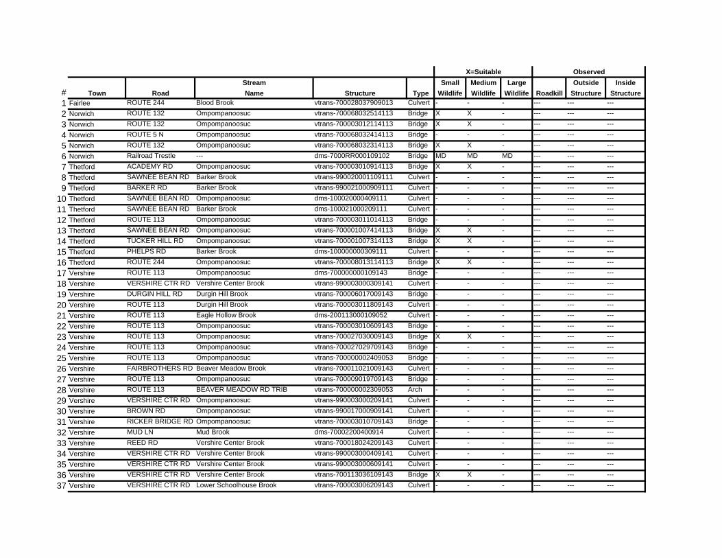
Stream Small Medium Large Outside Inside# Town Road Name Structure Type Wildlife Wildlife Wildlife Roadkill Structure Structure1 Fairlee ROUTE 244 Blood Brook vtrans-700028037909013 Culvert - - - --- --- ---
2 Norwich ROUTE 132 Ompompanoosuc vtrans-700068032514113 Bridge X X - --- --- ---
3 Norwich ROUTE 132 Ompompanoosuc vtrans-700003012114113 Bridge X X - --- --- ---
4 Norwich ROUTE 5 N Ompompanoosuc vtrans-700068032414113 Bridge - - - --- --- ---
5 Norwich ROUTE 132 Ompompanoosuc vtrans-700068032314113 Bridge X X - --- --- ---
6 Norwich Railroad Trestle --- dms-7000RR000109102 Bridge MD MD MD --- --- ---
7 Thetford ACADEMY RD Ompompanoosuc vtrans-700003010914113 Bridge X X - --- --- ---
8 Thetford SAWNEE BEAN RD Barker Brook vtrans-990020001109111 Culvert - - - --- --- ---
9 Thetford BARKER RD Barker Brook vtrans-990021000909111 Culvert - - - --- --- ---
10 Thetford SAWNEE BEAN RD Ompompanoosuc dms-100020000409111 Culvert - - - --- --- ---
11 Thetford SAWNEE BEAN RD Barker Brook dms-100021000209111 Culvert - - - --- --- ---
12 Thetford ROUTE 113 Ompompanoosuc vtrans-700003011014113 Bridge - - - --- --- ---
13 Thetford SAWNEE BEAN RD Ompompanoosuc vtrans-700001007414113 Bridge X X - --- --- ---
14 Thetford TUCKER HILL RD Ompompanoosuc vtrans-700001007314113 Bridge X X - --- --- ---
15 Thetford PHELPS RD Barker Brook dms-100000000309111 Culvert - - - --- --- ---
16 Thetford ROUTE 244 Ompompanoosuc vtrans-700008013114113 Bridge X X - --- --- ---
17 Vershire ROUTE 113 Ompompanoosuc dms-700000000109143 Bridge - - - --- --- ---
18 Vershire VERSHIRE CTR RD Vershire Center Brook vtrans-990003000309141 Culvert - - - --- --- ---
19 Vershire DURGIN HILL RD Durgin Hill Brook vtrans-700006017009143 Bridge - - - --- --- ---
20 Vershire ROUTE 113 Durgin Hill Brook vtrans-700003011809143 Culvert - - - --- --- ---
21 Vershire ROUTE 113 Eagle Hollow Brook dms-200113000109052 Culvert - - - --- --- ---
22 Vershire ROUTE 113 Ompompanoosuc vtrans-700003010609143 Bridge - - - --- --- ---
23 Vershire ROUTE 113 Ompompanoosuc vtrans-700027030009143 Bridge X X - --- --- ---
24 Vershire ROUTE 113 Ompompanoosuc vtrans-700027029709143 Bridge - - - --- --- ---
25 Vershire ROUTE 113 Ompompanoosuc vtrans-700000002409053 Bridge - - - --- --- ---
26 Vershire FAIRBROTHERS RD Beaver Meadow Brook vtrans-700011021009143 Culvert - - - --- --- ---
27 Vershire ROUTE 113 Ompompanoosuc vtrans-700009019709143 Bridge - - - --- --- ---
28 Vershire ROUTE 113 BEAVER MEADOW RD TRIB vtrans-700000002309053 Arch - - - --- --- ---
29 Vershire VERSHIRE CTR RD Ompompanoosuc vtrans-990003000209141 Culvert - - - --- --- ---
30 Vershire BROWN RD Ompompanoosuc vtrans-990017000909141 Culvert - - - --- --- ---
31 Vershire RICKER BRIDGE RD Ompompanoosuc vtrans-700003010709143 Bridge - - - --- --- ---
32 Vershire MUD LN Mud Brook dms-70002200400914 Culvert - - - --- --- ---
33 Vershire REED RD Vershire Center Brook vtrans-700018024209143 Culvert - - - --- --- ---
34 Vershire VERSHIRE CTR RD Vershire Center Brook vtrans-990003000409141 Culvert - - - --- --- ---
35 Vershire VERSHIRE CTR RD Vershire Center Brook vtrans-990003000609141 Culvert - - - --- --- ---
36 Vershire VERSHIRE CTR RD Vershire Center Brook vtrans-700113036109143 Bridge X X - --- --- ---
37 Vershire VERSHIRE CTR RD Lower Schoolhouse Brook vtrans-700003006209143 Culvert - - - --- --- ---
ObservedX=Suitable

Stream Small Medium Large Outside Inside# Town Road Name Structure Type Wildlife Wildlife Wildlife Roadkill Structure Structure
ObservedX=Suitable
38 Vershire VERSHIRE CTR RD Upper Schoolhouse Brook vtrans-700003006709143 Culvert - - - --- --- ---
39 Vershire MERO RD Mero Brook vtrans-990036001009141 Culvert - - - --- --- ---
40 Vershire MERO RD Mero Brook vtrans-700036033209143 Culvert - - - --- --- ---
41 Vershire EAGLE HOLLOW RD Eagle Hollow Brook vtrans-700003011209143 Culvert - - - --- --- ---
42 Vershire MUD LN Mud Brook trib to Vershire Ctr Bk vtrans-700022027509143 Culvert - - - --- --- ---
43 Vershire S VERSHIRE RD Schoolhouse Brook vtrans-700002005009143 Bridge X X - --- --- ---
44 Vershire MERO RD Schoolhouse Brook dms-40091400809141 Culvert - - - --- --- ---
45 Vershire S VERSHIRE RD Schoolhouse Brook vtrans-700038035309143 Bridge - - - --- --- ---
46 Vershire S VERSHIRE RD Schoolhouse Brook vtrans-990038001109141 Culvert - - - --- --- ---
47 Vershire AYERS RD Lower Schoolhouse Brook vtrans-990035000709141 Culvert - - - --- --- ---
48 West Fairlee BEAR NOTCH RD Bear Notch Brook vtrans-990017001109161 Bridge X - - --- --- ---
49 West Fairlee RD Beaver Meadow Brook dms-100020000509161 Culvert - - - --- --- ---
50 West Fairlee RD Beaver Meadow Brook dms-100020000609161 Culvert - - - --- --- ---
51 West Fairlee GODFREY RD Blood Brook vtrans-990025001309161 Culvert - - - --- --- ---
52 West Fairlee WILD HILL RD Wild Hill Brook vtrans-990002000109161 Bridge - - - --- --- ---
53 West Fairlee MIDDLEBROOK RD Middle Brook vtrans-990002000409161 Culvert - - - --- --- ---
54 West Fairlee MIDDLEBROOK RD Middle Brook vtrans-990002000509161 Culvert - - - --- --- ---
55 West Fairlee ROUTE 244 Middle Brook vtrans-990040000809111 Bridge - - - --- --- ---
56 West Fairlee BEANVILLE RD Schoolhouse Brook vtrans-700002005109143 Arch - - - --- --- ---
57 West Fairlee MARSH HILL RD Blood Brook vtrans-990024000709161 Culvert - - - --- --- ---
58 West Fairlee KING HILL RD Blood Brook vtrans-990026001409161 Bridge - - - --- --- ---
59 West Fairlee SCRUTTON HILL RD Middle Brook vtrans-990005001209161 Culvert - - - --- --- ---
60 West Fairlee MARSH HILL RD Middle Brook vtrans-990024000809161 Bridge - - - --- --- ---
61 West Fairlee RD Beaver Meadow Brook vtrans-990020001009161 Culvert - - - --- --- ---
62 West Fairlee RD Beaver Meadow Brook vtrans-990020000909161 Bridge X - - --- --- ---
63 West Fairlee CROSSROAD Ompompanoosuc vtrans-700011020209143 Bridge - - - --- --- ---
64 West Fairlee BACK ST Schoolhouse Brook vtrans-700003013709053 Bridge - - - --- --- ---
65 West Fairlee Mill Street Ompompanoosuc vtrans-700000002209053 Bridge - - - --- --- ---
66 West Fairlee RD Beaver Meadow Brook vtrans-990020000609161 Culvert - - - --- --- ---
67 West Fairlee ROUTE 113 Trib Schoolhouse Brook vtrans-700011020909143 Bridge - - - --- --- ---
68 West Fairlee MIDDLEBROOK RD Middle Brook vtrans-990002000209161 Culvert - - - --- --- ---
69 West Fairlee MIDDLEBROOK RD Bear Notch Brook vtrans-990002000309161 Culvert - - - --- --- ---