
BOEM 2017-064 2016 Assessment of Oil and Gas Resources … · This report documents the 2016...
20
2016 Assessment of Oil and Gas Resources: Alaska Outer Continental Shelf Region OCS Report BOEM 2017-064 U.S. Department of the Interior Bureau of Ocean Energy Management Alaska Outer Continental Shelf Region
Transcript of BOEM 2017-064 2016 Assessment of Oil and Gas Resources … · This report documents the 2016...

2016 Assessment of Oil and Gas Resources: Alaska Outer Continental Shelf Region
OCS Report BOEM 2017-064
U.S. Department of the Interior Bureau of Ocean Energy Management Alaska Outer Continental Shelf Region

2016 Assessment of Oil and Gas Resources: Alaska Outer Continental Shelf Region
Alaska Resource Evaluation and Economic Analysis Section Prepared by Daniel Lasco
.
Front Cover. Map of the Alaska OCS Region showing planning areas and the
assessed limit of Undiscovered Technically Recoverable Resources defined
for the 2016 National Assessment. Planning areas are as annotated on the
map.
U.S. Department of the Interior Bureau of Ocean Energy Management Anchorage, Alaska Alaska Outer Continental Shelf Region August 28, 2017

ii
TableofContents
Table of Contents ......................................................................................................................... ii
List of Figures .............................................................................................................................. iii
List of Tables ................................................................................................................................ iii
Abbreviations and Acronyms ................................................................................................... iv
Introduction ...................................................................................................................................1
Planning Areas ..............................................................................................................................3
Resource Assessment Results ......................................................................................................5
References ....................................................................................................................................12
Glossary ........................................................................................................................................13

iii
ListofFigures
Figure 1. Map showing Alaska OCS Region, Planning Areas, and Assessed Area……………………….3
Figure 2. Undiscovered Technically Recoverable Oil and Gas Resources of the Alaska OCS Region by
planning area………………………………………………………………………………………….7
Figure 3. Undiscovered Economically Recoverable Oil Resources of the Alaska OCS Region by
planning area………………………………………………………………………………………...10
Figure 4. Undiscovered Economically Recoverable Gas Resources of the Alaska OCS Region by
planning area………………………………………………………………………………………...11
ListofTables
Table 1. Undiscovered Technically Recoverable Oil and Gas Resources of the Alaska OCS Region by
Planning Area ......................................................................................................................................... 6
Table 2. Undiscovered Economically Recoverable Oil and Gas Resources in the Alaska OCS
Region for six economic scenarios by Planning Area ....................................................................... 9

iv
Abbreviations and Acronyms
API American Petroleum Institute OAPI Degrees API, a unit of measurement of the American Petroleum Institute for the gravity of oil
Bbbl billion (109) barrels
bbl barrels
BBOE billion (109) barrels of combined oil‐equivalent resources
BOE barrels of combined oil‐equivalent resources
BOEM Bureau of Ocean Energy Management
cf cubic feet
DOI Department of the Interior
Mcf thousand (103) cubic feet
MMbbl million (106) barrels
OCS Outer Continental Shelf
Tcf trillion (1012) cubic feet
UERR Undiscovered economically recoverable resources
UTRR Undiscovered technically recoverable resources
U.S. United States
1
Introduction
The Bureau of Ocean Energy Management (BOEM) is charged with the management and development of
energy and mineral resources on the Outer Continental Shelf (OCS) of the United States in an
environmentally and economically responsible way. This mandate includes assessing the amounts of
technically and economically recoverable undiscovered oil and natural gas resources located outside
known oil and gas accumulations for the U.S OCS.
This report documents the 2016 Assessment of undiscovered technically and economically recoverable oil
and gas resources of the Alaska OCS Region of the United States. The Alaska OCS Region comprises
submerged lands that extend from the seaward limit of State of Alaska waters (three miles offshore) to
the U.S.‐Canadian maritime boundary in southeastern Alaska, west and north to the U.S.‐Russian
maritime boundary in the Bering Sea, and the northeast to the U.S‐Canada maritime boundary in the
Beaufort Sea (Figure 1).
The 2016 assessment of the Alaska OCS Region provides an updated appraisal of the location and volume
of undiscovered resources. It is based upon geological work that was performed for the 1995
Undiscovered Oil and Gas Resources, Alaska Federal Offshore and compiled into OCS Report MMS 98‐
0054 (Sherwood et al., 1998). New well data, geologic interpretations, and technologies (as of January 1st,
2014) are incorporated with updated economic scenarios into the 2016 assessment by a team of
geoscientists and engineers in Anchorage, Alaska. The team utilizes a large volume and variety of
proprietary and nonproprietary data (including geologic, geochemical, geophysical, petroleum
engineering, and economic data). The hydrocarbon resources assessed include oil (including crude oil and
condensate) and natural gas (including associated and non‐associated gas).
There are many uncertainties regarding the geologic framework and petroleum geologic characteristics of
a given area and the location and volume of its undiscovered oil and gas resources. BOEM uses a play‐
based approach for identification and estimation of geologic resource parameters. BOEM employs
probabilistic techniques to capture the range of uncertainty in the geologic resource assessment factors.
The results are reported as a range of values which includes a low estimate corresponding to the 95th
percentile value of the distribution (the probability of existence of the estimated volume or more is 95 in
100), a mean (or expected) estimate corresponding to the statistical average of all values in the
distribution, and a high estimate corresponding to the 5th percentile value of the distribution (the
probability of existence of the estimated volume or more is 5 in 100).
For the purpose of this report, Oil is a liquid hydrocarbon resource, which may include crude oil and/or
condensate. Crude oil exists in a liquid state in both subsurface and surface conditions. Condensate
(natural gas liquids) is a very high‐gravity (generally greater than 50o API) liquid, it may exist in a
dissolved gaseous state at subsurface conditions but drops out as liquid at surface conditions. The
volumetric estimates of oil resources from this assessment represent combined volumes of crude oil and
condensate and are reported as standard stock tank barrels (barrels or bbl).

2
Natural gas is a gaseous hydrocarbon resource, which may include associated and/or non‐associated gas.
The terms natural gas and gas are used interchangeably in this report. Associated gas exists in spatial
association with crude oil; it may exist in the subsurface as free (undissolved) gas within a “gas cap” or as
gas that is dissolved in crude oil (“solution gas”). Non‐associated gas (dry gas) does not exist in association
with crude oil. Gas resources that can be removed from the subsurface with conventional extraction
techniques are assessed for this project; other gas resources (for example, gas shale and gas hydrates) are
not assessed. The volumetric estimates of gas resources from this assessment represent aggregate
volumes of associated and non‐associated gas and are reported as standard cubic feet (hereafter “cubic
feet” or “cf”).
Oil‐equivalent gas is a volume of gas (associated and/or non‐associated) expressed in terms of its energy
equivalence to oil (that is, 5,620 cubic feet of gas per barrel of oil) and is reported as barrels. The
combined volume of oil and oil‐equivalent gas resources is referred to as combined oil‐equivalent resources
or BOE (barrels of oil equivalent) and is reported as barrels.
Two categories of undiscovered resources were assessed: undiscovered technically recoverable resources
(UTRR) are those that can be removed from the subsurface with conventional extraction techniques;
undiscovered economically recoverable resources (UERR) are those undiscovered technically recoverable
resources that can be extracted profitably under specified economic and technological conditions.
The total resource endowment is the sum of the discovered resources (original recoverable reserves) and
undiscovered resources and has been estimated for areas where resources have been discovered. For
areas where there are no known discoveries, the amount of undiscovered technically recoverable
resources comprises the total resource endowment.
The Alaska OCS includes more than one billion acres and over 6,000 miles of coastline spread across 15
formal planning areas. Four planning areas (Aleutian Arc, Aleutian Basin, Bowers Basin, and St.
Matthew‐Hall) were not evaluated in this assessment due to their negligible petroleum potential
(Sherwood et al., 1998). The remaining 11 planning areas contain the 73 petroleum geological plays (groups
of geologically related hydrocarbon accumulations) which are assessed with quantifiable hydrocarbon
resources. Several planning areas shown in Figure 1 contain a delineation representing the UTRR limit.
Seaward of this limit, BOEM assesses no oil or gas accumulations that can be recovered using
conventional technology. In some cases, this is based on an assessment of the underlying geology, where
the geologic components necessary for a working petroleum system are not believed to exist (such as
around the Aleutian Arc). In other cases, such as in the Arctic Beaufort and Chukchi Seas, current
technology could not produce from oil or gas fields outside the UTRR limit due to the extreme ice
conditions present in the region for most of the year.

3
Figure 1: Map showing Alaska OCS Region, Planning Areas, and Assessed Area.
Planning Areas
For lease planning purposes, the Alaska Region is divided into fifteen planning areas (Figure 1), which
are based on jurisdictional, rather than on natural geologic or geographic boundaries. All but four
planning areas (Aleutian Arc, Aleutian Basin, Bowers Basin, and St. Matthew‐Hall) are assessed for this
report.
The Chukchi Sea OCS Planning Area of offshore northwestern Alaska has an eastern boundary near
Point Barrow (156º W Longitude) and a western boundary bordering the Russian waters of the
Chukchi shelf (169º 58’ 37’’ W Longitude). It extends from near Point Hope (68º20’ N Latitude)
northward to 75º N Latitude. The 2016 assessment of the Chukchi Sea OCS Planning Area identified
29 exploration plays, 27 of which were assessed with quantifiable hydrocarbon resources. The
planning area is oil‐prone, with fifty‐three percent of the UTRR consisting of oil and condensate.
The Beaufort Sea OCS Planning Area extends from the 3‐mile limit of the State of Alaska waters
northward to 75º N Latitude. However, the engineering challenges associated with oil and gas
production in waters deeper than 500 meters in the Arctic Ocean were considered too great to
overcome with conventional technology and thus were not assessed. The planning area is bounded

4
on the west near Utqiagvik (formally Barrow) (156º W Longitude) and on the east at the Canadian
maritime boundary. The 2016 assessment of the Beaufort Sea OCS Planning Area identified 14
exploration plays. Individual plays are mostly oil prone however several plays are gas‐prone.
The Hope Basin OCS Planning Area lies in the southern Chukchi Sea south of Point Hope (68º20’ N
Latitude) between the northwest coast of Alaska and the U.S.‐Russia maritime boundary. The 2016
assessment of the Hope Basin OCS Planning Area identified four exploration plays, three of which
were assessed for their oil and gas potential. The three quantified plays in the Hope Basin OCS
Planning Area are predominantly gas plays with a minor volume of oil in smaller, mixed (oil and
gas) pools.
The Navarin Basin OCS Planning Area is bounded on the North and West by the U.S.‐Russia
maritime boundary to 63º N Latitude. To the southwest, the 200 meter isobath represents the UTRR
limit of the Navarin Basin OCS Planning Area. The planning area extends southward to 58º N
Latitude and east to 174º W Longitude. The 2016 assessment of the Navarin Basin OCS Planning
Area identified six exploration plays, five of which were assessed for their oil and gas potential. The
planning area is gas‐prone, with 63% of the undiscovered hydrocarbon potential consisting of
natural gas with some associated oil and/or gas condensate.
The North Aleutian Basin OCS Planning Area extends from the 3‐mile limit of the State of Alaska
waters on the south and east and is bounded on the north at 59º N Latitude. The planning area
extends to the west to 165º W Longitude. The 2016 assessment of the North Aleutian Basin OCS
Planning Area identified six exploration plays, five of which were assessed for quantifiable oil and
gas potential. The planning area is gas‐prone, with 67% of the undiscovered hydrocarbon potential
consisting of natural gas.
The St. George Basin OCS Planning Area extends from the 3‐mile limit of the State of Alaska waters
on the south to 59º N Latitude. It is bounded on the east by the North Aleutian Basin OCS Planning
Area (165º W Longitude) and on the northwest by the Navarin Basin and Aleutian Basin OCS
Planning Areas (174º W Longitude) and southwest by the Bowers Basin OCS Planning Area (171º W
Longitude). The 2016 assessment of the St. George Basin OCS Planning Area identified four
exploration plays. The planning area is gas‐prone with 70% of the undiscovered hydrocarbon
potential consisting of natural gas.
The Norton Basin OCS Planning Area is bounded by the Seward Peninsula on the north and the
Yukon Delta and St. Lawrence Island (63º N Latitude) on the south and southwest. The western
boundary is defined by the United States – Russia Convention Line of 1867. The 2016 assessment of
the Norton Basin OCS Planning Area identified four exploration plays which are assessed for their
oil and gas potential. The planning area is gas‐prone as 100% of the UTRR is expected to exist as
natural gas and condensate.
The Cook Inlet OCS Planning Area is located in offshore south‐central Alaska between the Kenai
Peninsula on the east and the Aleutian Range to the west. The planning area extends southward
through the waters of the Shelikof Strait just past Kodiak Island. The Federal portion of the waters of
5
Cook Inlet and Shelikof Straight begin 3 miles from the State of Alaska shoreline. The northern part
of the inlet was not assessed as it is entirely within the jurisdiction of the State of Alaska. The 2016
assessment of the Cook Inlet OCS Planning Area identified four exploration plays. The majority of
resources (83%) in the planning area are modeled to exist as liquid hydrocarbons (oil and
condensate). One geologic play in the Cook Inlet was modeled as a gas play (with insignificant
condensate).
The Gulf of Alaska OCS Planning Area extends along an 850‐mile long segment of the Alaska
continental margin from the southwest tip of the Kenai Peninsula on the west to Dixon Entrance at
the U.S.‐Canadian border on the southeast. It extends from the 3‐mile limit of the State of Alaska
waters seaward to approximately the 2,000‐meter isobath on the north (continental) side of the
Amatuli trough. The 2016 assessment of the Gulf of Alaska OCS Planning Area identified five
exploration plays. The planning area is gas‐prone with 57% of the hydrocarbon resources modeled
to exist as natural gas.
The Shumagin OCS Planning Area extends from the Kodiak OCS Planning Area in the northeast
(156º W Longitude) to just past the Sanak Islands, near the end of the Alaska Peninsula. The assessed
area extends from the 3‐mile limit of the State of Alaska waters seaward to approximately the 2,000
meter isobath on the northern (continental) side of the Aleutian trench. The 2016 assessment
identified one exploration play. The planning area is highly gas‐prone (no free oil) with natural gas
comprising 87% of the UTRR and the remainder present as condensate.
The Kodiak OCS Planning Area comprises the Federal offshore lands on the continental shelf and
slope surrounding the Pacific coastline of the Kodiak archipelago, landward of the Aleutian trench.
The planning area extends from its northeastern boundary with the Gulf of Alaska OCS Planning
Area, along the coastline of the Kodiak archipelago and along the Aleutian trench to the boundary
with the Shumagin Planning Area (156º W Longitude). The boundary of the assessed area extends
from the 3‐mile limit of the State of Alaska waters seaward to approximately the 2,000 meter isobath
on the northern (continental) side of the Aleutian trench. The 2016 assessment identified one
exploration play. The planning area is gas‐prone with natural gas comprising 87%of the UTRR.
Resource Assessment Results
Undiscovered Technically Recoverable Resources (UTRR)
Estimates of the total volume of undiscovered technically recoverable resources in the Region are
developed by statistically aggregating the constituent play estimates. The total risked oil volume of
UTRR (including crude oil and condensate) of the Alaska Region is estimated to range from 19.10 Bbbl
(95% probability) to 36.43 Bbbl (5% probability) with a mean estimate of 26.61 Bbbl (Table 1). The
Chukchi Sea and Beaufort Sea Planning Areas are estimated to contain 88.6% (23.6 Bbo) of the UTRR of
crude oil in the Region. The total volume of undiscovered technically recoverable gas resources
(including associated and nonassociated gas) is estimated to range from 96.51 Tcf (95% probability) to

6
166.85 Tcf (5% probability) with a mean estimate of 131.45 Tcf. As with oil resources, the largest volumes
of gas are estimated to exist in the Chukchi Sea and Beaufort Sea Planning Areas (76.77 Tcf and 27.64 Tcf
respectively).
The Alaska OCS is assessed to contain a total volume of (mean estimates) undiscovered technically
recoverable resources (UTRR) of 50.00 billion barrels of oil equivalent (BBOE). Table 1 presents detailed
UTRR values by planning area for the low (95th percentile), mean, and high (5th percentiles) estimates
respectively. Figure 2 graphically displays the mean UTRR values by planning area.
Table 1: Undiscovered Technically Recoverable Oil and Gas Resources of the Alaska OCS Region by planning area.
Resource values are in billon barrels of oil (Bbbl), trillion cubic feet of gas (Tcf) and billion barrel equivalent (BBOE) for barrel of oil equivalent. 95% indicates a 95 percent chance of at least the amount listed; 5% indicates a 5 percent chance of at least the amount listed. Only mean values are additive. Some total mean values may not be equal the sum of the component values due to independent rounding of tabulated values.
Alaska OCS Region
Planning Area 95% Mean 5% 95% Mean 5% 95% Mean 5%
Chukchi Sea 9.30 15.38 23.08 48.88 76.77 111.44 17.99 29.04 42.91Beaufort Sea 4.11 8.22 13.72 13.92 27.64 43.78 6.59 13.14 21.51Hope Basin 0.00 0.15 0.45 0.00 3.77 10.40 0.00 0.82 2.30Navarin Basin 0.00 0.13 0.42 0.00 1.22 3.67 0.00 0.35 1.07North Aleutian Basin 0.12 0.75 1.82 1.47 8.62 17.37 0.38 2.29 4.91St. George Basin 0.00 0.21 0.57 0.00 2.80 6.69 0.00 0.71 1.76Norton Basin 0.00 0.06 0.17 0.00 3.06 9.65 0.00 0.60 1.89Cook Inlet 0.25 1.01 2.01 0.50 1.20 1.97 0.34 1.23 2.36Gulf of Alaska 0.13 0.63 1.45 0.71 4.04 9.23 0.25 1.34 3.09Shumagin 0.00 0.01 0.05 0.00 0.49 2.04 0.00 0.10 0.42Kodiak 0.00 0.05 0.20 0.00 1.84 7.62 0.00 0.38 1.55
Alaska OCS Total 19.10 26.61 36.43 96.51 131.45 166.85 36.28 50.00 66.12
OIL (Bbbl) GAS (Tcf) BOE (BBOE)
Undiscovered Technically Recoverable Resources (UTRR)

7
Figure 2: Undiscovered Technically Recoverable Oil and Gas Resources of the Alaska OCS Region by planning area.
0.05
0.01
0.63
1.01
0.06
0.21
0.75
0.13
0.15
8.22
15.38
1.84
0.49
4.04
1.20
3.06
2.80
8.62
1.22
3.77
27.64
76.77
0.38
0.10
1.34
1.23
0.60
0.71
2.29
0.35
0.82
13.14
29.04
0.00 10.00 20.00 30.00 40.00 50.00 60.00 70.00 80.00
Kodiak
Shumagin
Gulf of Alaska
Cook Inlet
Norton Basin
St. George Basin
North Aleutian Basin
Navarin Basin
Hope Basin
Beaufort Sea
Chukchi Sea
Volume of Resource (Mean Values)
BOE (BBOE)GAS (Tcf)OIL (Bbbl)

8
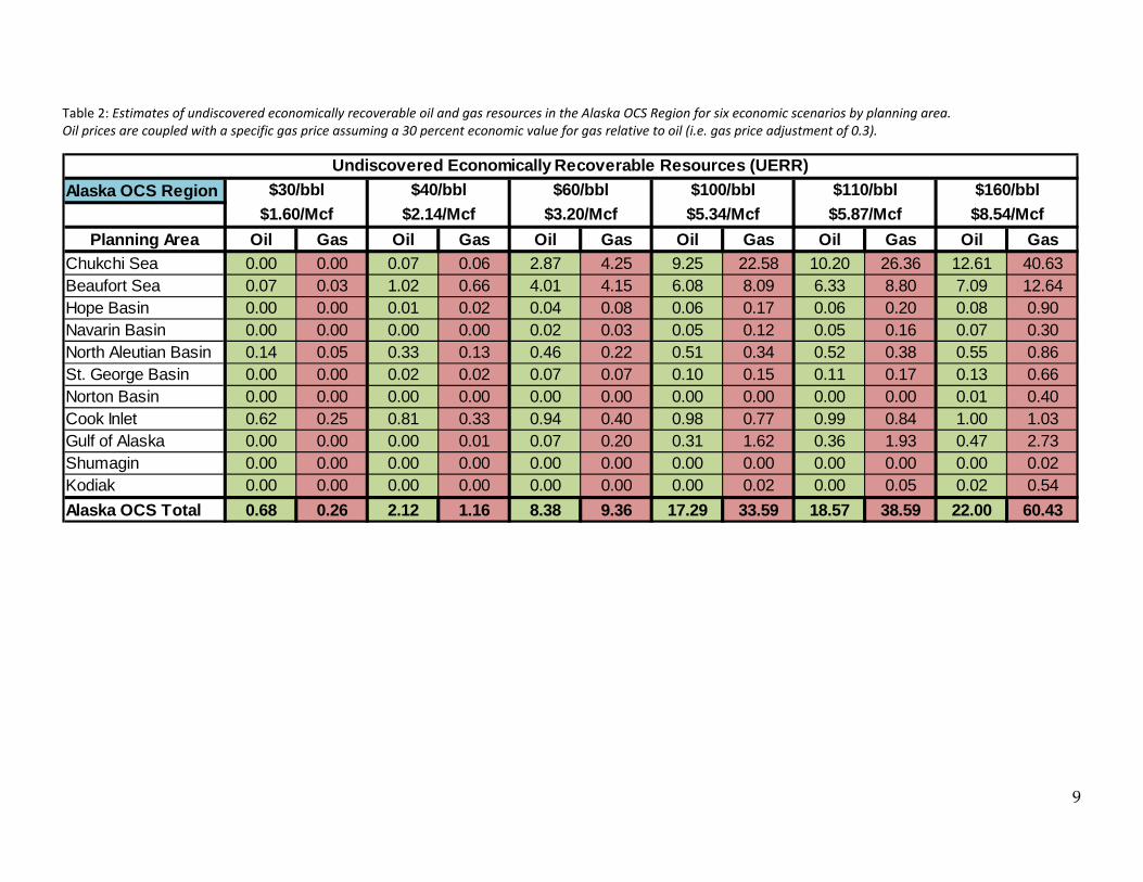
Undiscovered Economically Recoverable Resources (UERR)
The fraction of UTRR that is estimated to comprise UERR varies based on several assumptions beyond
those implicit in the calculation of geologic resources, including commodity price environment, cost
environment, and relationship of gas price to oil price. In general, larger volumes of resources are
estimated to be economically recoverable under more favorable economic conditions. For example, in this
assessment, the Region’s UERR were estimated at January 1, 2014 market conditions. Using a price pair
of $100 per bbl of oil and $5.34 per Mcf of natural gas, the total volume of UERR is estimated to be 17.29
Bbbl of oil and 33.59 Tcf of natural gas (mean values). Economic scenarios with more favorable (higher
prices) economic conditions yield higher UERR volumes while less favorable (lower prices) economic
conditions yield lower UERR volumes.
The total volumes of UERR in the Region are assessed for a range of economic scenarios. For each, oil
prices are coupled with a specific gas price assuming a 30 percent economic value for gas relative to oil
(i.e. a gas price adjustment of 0.3). These oil/gas price pairs are: $30/bbl and $1.60/Mcf; $40/bbl and
$2.14/Mcf; $60/bbl and $3.20/Mcf; $100/bbl and $5.34/Mcf; $110/bbl and $5.87/Mcf; and $160/bbl and
$8.54/Mcf. The economic results for the entire Alaska OCS are generated by statistically aggregating the
constituent planning area estimates. Estimates of economically recoverable resources at several pricing
scenarios by planning area are given in Table 2. Also, estimates of economically recoverable resources are
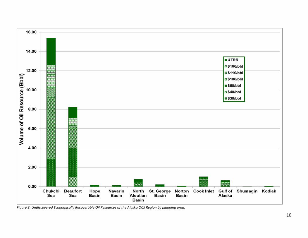
graphically illustrated as depicted in Figure 3 and Figure 4.
Resource Endowment of the Alaska OCS
The total resource endowment of the Region is estimated to be 26.65 Bbbl of oil and 131.45 Tcf of gas
(mean estimates). The discovered oil resource of 40 MMbbl (BOEM, 2016) is associated with the joint
Federal‐State Northstar field in the Beaufort Sea. As the Federal OCS in Alaska is mostly unexplored,
UTRR are estimated to comprise nearly the entirety (99.92%) of the total oil and gas resource endowment
of the Region.
9
Table 2: Estimates of undiscovered economically recoverable oil and gas resources in the Alaska OCS Region for six economic scenarios by planning area. Oil prices are coupled with a specific gas price assuming a 30 percent economic value for gas relative to oil (i.e. gas price adjustment of 0.3).
Alaska OCS Region
Planning Area Oil Gas Oil Gas Oil Gas Oil Gas Oil Gas Oil Gas
Chukchi Sea 0.00 0.00 0.07 0.06 2.87 4.25 9.25 22.58 10.20 26.36 12.61 40.63Beaufort Sea 0.07 0.03 1.02 0.66 4.01 4.15 6.08 8.09 6.33 8.80 7.09 12.64Hope Basin 0.00 0.00 0.01 0.02 0.04 0.08 0.06 0.17 0.06 0.20 0.08 0.90Navarin Basin 0.00 0.00 0.00 0.00 0.02 0.03 0.05 0.12 0.05 0.16 0.07 0.30North Aleutian Basin 0.14 0.05 0.33 0.13 0.46 0.22 0.51 0.34 0.52 0.38 0.55 0.86St. George Basin 0.00 0.00 0.02 0.02 0.07 0.07 0.10 0.15 0.11 0.17 0.13 0.66Norton Basin 0.00 0.00 0.00 0.00 0.00 0.00 0.00 0.00 0.00 0.00 0.01 0.40Cook Inlet 0.62 0.25 0.81 0.33 0.94 0.40 0.98 0.77 0.99 0.84 1.00 1.03Gulf of Alaska 0.00 0.00 0.00 0.01 0.07 0.20 0.31 1.62 0.36 1.93 0.47 2.73Shumagin 0.00 0.00 0.00 0.00 0.00 0.00 0.00 0.00 0.00 0.00 0.00 0.02Kodiak 0.00 0.00 0.00 0.00 0.00 0.00 0.00 0.02 0.00 0.05 0.02 0.54
Alaska OCS Total 0.68 0.26 2.12 1.16 8.38 9.36 17.29 33.59 18.57 38.59 22.00 60.43
Undiscovered Economically Recoverable Resources (UERR)
$100/bbl
$5.34/Mcf
$110/bbl
$5.87/Mcf
$160/bbl
$8.54/Mcf$1.60/Mcf
$30/bbl $40/bbl
$2.14/Mcf
$60/bbl
$3.20/Mcf
10
Figure 3: Undiscovered Economically Recoverable Oil Resources of the Alaska OCS Region by planning area.

11
Figure 4: Undiscovered Economically Recoverable Gas Resources of the Alaska OCS Region by planning area.

12
References
1. Bureau of Ocean Energy Management, 2016. Assessment of Undiscovered Technically Recoverable
Oil and Gas Resources of the Nation’s Outer Continental Shelf, 2016. BOEM Fact Sheet RED‐2016‐
01b, 8 p. https://www.boem.gov/2016‐National‐Assessment‐Fact‐Sheet/
2. Sherwood, Kirk W., et al. (18 additional authors) 1998, MMS (Minerals Management Service, U.S.
Department of the Interior), Undiscovered Oil and Gas Resources, Alaska Federal Offshore, January
1995, (OCS Report MMS 98‐0054). https://www.boem.gov/About‐BOEM/BOEM‐Regions/Alaska‐
Region/Resource‐Evaluation/ta98‐0054.aspx

13
Glossary
Barrel: A volumetric unit of measure for crude oil equivalent to 42 U.S. gallons.
Basin (geologic basin): A basin is a depressed and geographically confined area of the
earth’s crust in which sediments accumulated and hydrocarbons may have formed.
Field: A field means an area consisting of a single reservoir or multiple reservoirs all on,
or related to, the same general geological structural feature or stratigraphic trapping
condition. Two or more reservoirs may be in a field, separated vertically by intervening
impervious strata or laterally by local geologic barriers, or both.
Outer Continental Shelf: The continental margin, including the shelf, slope, and rise,
beyond the line that marks the boundary of state ownership; that part of the seabed
under Federal jurisdiction.
Play: A group of known and/or postulated pools that share common geologic,
geographic, and temporal properties, such as hydrocarbon generation, migration,
reservoir development, and timing of entrapment.
Conceptual plays: Those plays in which hydrocarbons have not been detected
but for which data suggest that hydrocarbon accumulations may exist.
Established plays: Those play in which hydrocarbon accumulations have been
discovered.
Production: Production is the cumulative quantity of petroleum that has been actually
recovered over a defined time period.
Pool: A pool is a discrete accumulation (discovered or undiscovered) of hydrocarbon
resources that are hydraulically separated from any other hydrocarbon accumulation; it
is typically related to a single stratigraphic interval or structural feature.
Planning Area: OCS planning areas are not based on geology or geography, but are
delineated based on political boundaries in the same fashions as state or county lines.
Prospect: A prospect is an untested geologic feature having the potential for trapping
and accumulating hydrocarbons.
Total resource endowment: This is the sum of the discovered resources (original
recoverable reserves) and undiscovered resources.

14
Undiscovered Resources: These are resources that have not been discovered but are
estimated to exist outside and between known accumulations based on broad geologic
knowledge and theory. Undiscovered resources may be categorized into:
Technically Recoverable Undiscovered Resources are resources that can be
removed from the subsurface with conventional extraction techniques (that is,
technology whose usage is considered common practice as of this assessment).
Economically Recoverable Undiscovered Resources are technically recoverable
resources that can be extracted profitably by conventional techniques under
specified economic conditions.

The Department of the Interior Mission
As the Nationʹs principal conservation agency, the Department of the Interior
has responsibility for most of our nationally owned public lands and natural
resources. This includes fostering sound use of our land and water resources;
protecting our fish, wildlife and biological diversity; preserving the
environmental and cultural values of our national parks and historical places;
and providing for the enjoyment of life through outdoor recreation. The
Department assesses our energy and mineral resources and works to ensure
that their development is in the best interests of all our people by encouraging
stewardship and citizen participation in their care. The Department also has a
major responsibility for American Indian reservation communities and for
people who live in island communities.
The Bureau of Ocean Energy Management
The Bureau of Ocean Energy Management (BOEM) works to manage the
exploration and development of the nationʹs offshore resources in a way that
appropriately balances economic development, energy independence, and
environmental protection through oil and gas leases, renewable energy
development and environmental reviews and studies.


![Crude Assay Report · 15 Vacuum Gas Oil Cuts - Gas Oil [325-370°C] 15 16 Vacuum Gas Oil Cuts - Gas Oil 1[370 - 540°C] 16 17 Vacuum Gas Oil Cuts - Heavy Vacuum Gas Oil [370 - 548°C]](https://static.fdocuments.in/doc/165x107/5e68681c2598ff04995c67bc/crude-assay-report-15-vacuum-gas-oil-cuts-gas-oil-325-370c-15-16-vacuum-gas.jpg)