Biodiversity and Geological Conservation - Cornwall · PDF filebiodiversity and geological...
36
Biodiversity and Geological Conservation Planning Good Practice Guidance for Cornwall November 2007
Transcript of Biodiversity and Geological Conservation - Cornwall · PDF filebiodiversity and geological...

Biodiversity and Geological Conservation
Planning Good Practice Guidancefor Cornwall
November 2007

Page 2

Contents 1 Introduction
1.1 Cornwall’s Wildlife and Wild Places 41.2 Impacts of Development 41.3 The Threat of Climate Change 41.4 The Marine Environment 41.5 The purpose and status of this Good Practice Guidance 51.6 Preparation of The Good Practice Guidance 51.7 What is Biodiversity? 51.8 What is Geodiversity? 51.9 Planning Policy Context 51.10 Protected Sites and Species 61.11 Permitted Development 7
2 The Development Process 2.1 Guiding principles for developers 82.2 The development control process 92.3 Stages in the process 10
Stage 1: Surveys and information gathering 10Stage 2: Design 15Stage 3: Construction 20Stage 4: Monitoring, management and enforcement 22
3 Case Studies 241 Residential development 252 Building conversion, extension or demolition 273 Coastal development 294 Industrial/commercial development on a brownfield site 315 Quarry/Mineral development 33
AppendicesAppendix 1 Organisation contacts and their role in planning 35
Page 3
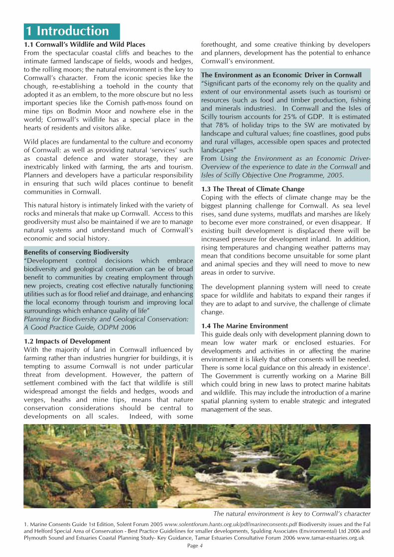
1.1 Cornwall’s Wildlife and Wild PlacesFrom the spectacular coastal cliffs and beaches to theintimate farmed landscape of fields, woods and hedges,to the rolling moors; the natural environment is the key toCornwall’s character. From the iconic species like thechough, re-establishing a toehold in the county thatadopted it as an emblem, to the more obscure but no lessimportant species like the Cornish path-moss found onmine tips on Bodmin Moor and nowhere else in theworld; Cornwall’s wildlife has a special place in thehearts of residents and visitors alike.
Wild places are fundamental to the culture and economyof Cornwall: as well as providing natural ‘services’ suchas coastal defence and water storage, they areinextricably linked with farming, the arts and tourism.Planners and developers have a particular responsibilityin ensuring that such wild places continue to benefitcommunities in Cornwall.
This natural history is intimately linked with the variety ofrocks and minerals that make up Cornwall. Access to thisgeodiversity must also be maintained if we are to managenatural systems and understand much of Cornwall’seconomic and social history.
Benefits of conserving Biodiversity“Development control decisions which embracebiodiversity and geological conservation can be of broadbenefit to communities by creating employment throughnew projects, creating cost effective naturally functioningutilities such as for flood relief and drainage, and enhancingthe local economy through tourism and improving localsurroundings which enhance quality of life”Planning for Biodiversity and Geological Conservation: A Good Practice Guide, ODPM 2006
1.2 Impacts of DevelopmentWith the majority of land in Cornwall influenced byfarming rather than industries hungrier for buildings, it istempting to assume Cornwall is not under particularthreat from development. However, the pattern ofsettlement combined with the fact that wildlife is stillwidespread amongst the fields and hedges, woods andverges, heaths and mine tips, means that natureconservation considerations should be central todevelopments on all scales. Indeed, with some
forethought, and some creative thinking by developersand planners, development has the potential to enhanceCornwall’s environment.
The Environment as an Economic Driver in Cornwall“Significant parts of the economy rely on the quality andextent of our environmental assets (such as tourism) orresources (such as food and timber production, fishingand minerals industries). In Cornwall and the Isles ofScilly tourism accounts for 25% of GDP. It is estimatedthat 78% of holiday trips to the SW are motivated bylandscape and cultural values; fine coastlines, good pubsand rural villages, accessible open spaces and protectedlandscapes”From Using the Environment as an Economic Driver-Overview of the experience to date in the Cornwall andIsles of Scilly Objective One Programme, 2005.
1.3 The Threat of Climate ChangeCoping with the effects of climate change may be thebiggest planning challenge for Cornwall. As sea levelrises, sand dune systems, mudflats and marshes are likelyto become ever more constrained, or even disappear. Ifexisting built development is displaced there will beincreased pressure for development inland. In addition,rising temperatures and changing weather patterns maymean that conditions become unsuitable for some plantand animal species and they will need to move to newareas in order to survive.
The development planning system will need to createspace for wildlife and habitats to expand their ranges ifthey are to adapt to and survive, the challenge of climatechange.
1.4 The Marine EnvironmentThis guide deals only with development planning down tomean low water mark or enclosed estuaries. Fordevelopments and activities in or affecting the marineenvironment it is likely that other consents will be needed.There is some local guidance on this already in existence1.The Government is currently working on a Marine Billwhich could bring in new laws to protect marine habitatsand wildlife. This may include the introduction of a marinespatial planning system to enable strategic and integratedmanagement of the seas.
Page 4
1. Marine Consents Guide 1st Edition, Solent Forum 2005 www.solentforum.hants.org.uk/pdf/marineconsents.pdf Biodiversity issues and the Faland Helford Special Area of Conservation - Best Practice Guidelines for smaller developments, Spalding Associates (Environmental) Ltd 2006 andPlymouth Sound and Estuaries Coastal Planning Study- Key Guidance, Tamar Estuaries Consultative Forum 2006 www.tamar-estuaries.org.uk
1 Introduction
The natural environment is key to Cornwall’s character

1.5 The Purpose and Status of this Good PracticeGuidanceThis Good Practice Guidance is designed to assist peoplewho are submitting and determining planning applicationsin Cornwall to understand how to ensure that biodiversityand where relevant geodiversity, are protected, conservedand enhanced as a consequence of development.
Whilst there are national publications and guidancedocuments2 about biodiversity and geodiversity, it wasfelt that there was a need for a document relevant to thewildlife and wild places of Cornwall, and to the scale ofdevelopment occurring in the county. This documentaims to address this need.
It is recommended that all the participating authoritiesformally adopt this document, initially as Good PracticeGuidance. As Local Development Frameworkpreparation progresses it is recommended that thisdocument becomes a Supplementary PlanningDocument (SPD).
1.6 Preparation of the Good Practice GuidanceThis document has been prepared by a working groupincluding Planning Officers from local authorities, theCornwall Wildlife Trust, Natural England and TheEnvironment Agency.
A wide consultation exercise has been completed.Details on the consultation can be found in theconsultation report
3.
1.7 What is Biodiversity?“Biodiversity” is the term applied to the variety of life onearth. Internationally, the importance of conservingbiodiversity has been recognised, with the UK being asignatory to the Convention on Biological Diversity.Following from this the UK government produced the UKBiodiversity Action Plan and the England BiodiversityStrategy4 which created a framework for action to
maintain and increase indigenous species populationsand habitat areas. This work was continued at a regionallevel with the South West Biodiversity Action Plan5 andImplementation Plan6 and for Cornwall throughCornwall’s Biodiversity Volumes 1-37.
1.8 What is Geodiversity?Geodiversity is the variety of rocks, minerals and fossilstogether with the variety of soils, natural processes andlandforms found within a particular region. Geodiversity isimportant because it underpins biodiversity with soils beingthe link between them. A Geodiversity Action Plan (GAP) forCornwall and the Isles of Scilly8 has recently been produced.
1.9 Planning Policy ContextAll planning authorities are required by both policy andstatute to take nature conservation into account whenmaking decisions on individual applications.
Countryside and Rights of Way Act 2000Section 74 states that ‘It is the duty of [Government] incarrying out…its functions, to have regard, so far as isconsistent with the proper exercise of those functions, tothe purpose of conserving biological diversity inaccordance with the Convention’ (on Biological Diversityfollowing the Rio Earth Summit in 1992). Section 74 alsocontains a list published by the Secretary of State forEnvironment, Food and Rural Affairs of habitats andspecies that are of principal importance to biodiversityconservation in England.
Planning and Compulsory Purchase Act 2004 Section 38 indicates that determination of planningapplications should be in accordance with the policies inthe development plan. In Cornwall this is currently theCounty Structure Plan, the individual District Local Plansand the County Council Waste and Minerals Local Plan.These contain policies for the protection of wildlife andgeology and all new development should accord withthese policies.
The County Structure Plan will be superseded in future bythe Regional Spatial Strategy, and Local Plans by LocalDevelopment Frameworks. These will also containpolicies for the protection of wildlife and geology and asthey replace the current plans new development shouldaccord with these policies.Local Plans and Local Development Frameworks areavailable from the local planning authorities or theirwebsites9.
Page 5
Praa Sands peat and head deposits - Geological diversity is reflectedin landforms and soils, and is closely linked with biodiversity
2. Planning for Biodiversity and Geological Conservation: A Guide to Good Practice ODPM March 2006, Planning Policy Statement 9: Biodiversityand Geological Conservation ODPM August 2005, Environmental Quality and Spatial Planning- Guidance to help in the preparation of RegionalSpatial Strategies and Local Development Frameworks- Countryside Agency and others June 2005. Publicly Available Specification PAS 2010-Planning to halt the loss of biodiversity - Biodiversity conservation standards for planning in the United Kingdom- Code of practice, BSI 2006 www.bsi-global.com 3. Biodiversity and Geological Conservation- Good Practice Guidance for Cornwall - Consultation Report, Cornwall Biodiversity Initiative 2007 4. Working with the grain of nature: A biodiversity strategy for England Department for Environment, Food and Rural Affairs, 2002 www.defra.gov.uk5. Action for Biodiversity in the South West: A series of habitat and species plans to guide delivery, South West Regional Biodiversity Partnership1997 www.swbiodiversity.org.uk6. South west Biodiversity implementation Plan- Biodiversity: A Natural Advantage for the South West, South West Regional Biodiversity Partnership2004 www.swbiodiversity.org.uk7. Cornwall’s Biodiversity Volume 3: Action Plans 2004, Cornwall Biodiversity Initiative 2004 www.cornwallwow.org.uk8. Geodiversity Action Plan - Cornwall and the Isles of Scilly 1st Edition, Cornwall Wildlife Trust 2005 www.cornwallgeology.org.uk.9. Caradon District Council www.caradon.gov.uk , Carrick District Council www.carrick.gov.uk , Kerrier District Council www.kerrier.gov.uk ,North Cornwall District Council www.ncdc.gov.uk , Restormel Borough Council www.restormel.gov.uk , Penwith District Councilwww.penwith.gov.uk , Cornwall County Council (minerals and waste) www.cornwall.gov.uk

Cornwall is currently moving from having six DistrictCouncils and a County Council to having a single UnitaryAuthority. The Unitary Authority will be in place from 2009and will be the only Local Planning Authority in Cornwall.
Planning Policy Statement 9- Biodiversity andGeological Conservation
PPS 9 sets out the government’s national planningpolicies on protection of biodiversity and geologicalconservation through the planning system. The keyprinciples of PPS 9 are summarised below:
1. Plan policies and planning decisions should be basedon up-to-date environmental information.2. Plan policies and planning decisions should aim tomaintain, and enhance, restore or add to biodiversity andgeological conservation interests.3. Plan policies should take a strategic approach to theconservation, enhancement and restoration ofbiodiversity and geological features.4. Plan policies should promote opportunities toincorporate biodiversity and geological features withinthe design of development.5. Development proposals where the principal objectiveis to conserve or enhance biodiversity and geologicalconservation interests should be permitted.6. The aim of planning decisions should be to preventharm to biodiversity and geological conservationinterests. If significant harm cannot be prevented,adequately mitigated against, or compensated for, thenplanning permission should be refused.
PPS 9 also includes information on how international,national and local sites should be handled through theplanning system and highlights the importance of ancientwoodland, other important natural habitats, networks ofhabitats and previously developed land.
Natural Environment and Rural Communities Act 2006Section 40 of the NERC Act states that:
‘Every public authority must, in exercising its functions,have regard, so far as is consistent with the properexercise of those functions, to the purpose of conservingbiodiversity. Where conserving biodiversity includes, inrelation to a living organism or type of habitat, restoringor enhancing a population or habitat’. Detailedinformation about the implications of the NERC Act forlocal authorities has been produced nationally10.
1.10 Protected sites and speciesIn addition to the protection provided through the planningsystem, species, habitats and geological features areprotected through legislation. This legislation and theprotection provided by planning controls operate in parallelto protect species and habitats. Both aspects must beconsidered by the Local Planning Authority and developers.
The main Acts and Regulations are: • Wildlife and Countryside Act 1981 (as amended)• Protection of Badgers Act 1992 • The Conservation (Natural Habitats, &c.) Regulations 1994 (as amended).• Hedgerow Regulations 1997 • Environmental Impact Assessment Regulations 1999• Countryside and Rights of Way Act 2000 • Natural Environment and Rural Communities Act 2006
The Joint Nature Conservation Committee (JNCC)website11 has more information on this legislation.
These Acts and Regulations together provide differinglevels of protection to a variety of sites, plants andanimals (including the places inhabited by particularspecies of plants and animals), and geological features.
Site designations in CornwallDesignations that cover sites of nature conservation and geological value in Cornwall include:Statutory international-Special Protection Areas (SPA)Special Area of Conservation (SAC)Statutory national-Site of Special Scientific Interest (SSSI)National Nature Reserve (NNR)Local-County Wildlife Site (CWS)- formerly CTNC sitesCounty Geological Site (CGS)- formerly RIGS sitesLocal Nature Reserve (LNR)Biodiversity Action Plan habitats-These include many coastal habitats, some grasslands, woodlands and wetlands. For more information on protected sites please refer tothe Joint Nature Conservation Committee website11. Formore information on BAP habitats refer to Cornwall BAPVolume 312 or contact The Environmental Records Centrefor Cornwall and the Isles of Scilly (ERCCIS) 01872273939 ext. 240.
Information on designated sites is also available in theLocal Planning Authority Local Plan/Local DevelopmentFramework. Alternatively, Natural England's ‘Nature onthe Map’ website contains information13
Page 6
10. Guidance for local authorities on implementing the Biodiversity Duty, Defra May 2007 www.defra.gov.uk11. Joint Nature Conservation Committee website www.jncc.gov.uk12. Cornwall’s Biodiversity Volume 3: Action Plans 2004, Cornwall Biodiversity Initiative 2004 www.cornwallwow.org.uk13. Natural England’s ‘Nature on the map’ website www.natureonthemap.org.uk
Local Planning Authorities are required to consultstatutory agencies on planning applications which affectstatutorily designated sites. Developers are encouragedto engage in pre-application discussions with planningauthorities and statutory agencies, this can help minimisedelays later in processing the application. Otherorganisations may be able to advise on local sites. A listof organisations and their role in the planning process isgiven in appendix 1.
Protected species in CornwallThe presence of a protected species is a materialconsideration in the planning decision. The onus is onthe Local Planning Authority, through its developmentcontrol role, to ensure that harmful effects on the speciesor its habitat are avoided. Even when planningpermission is granted, the developer must comply withprotected species legislation whilst carrying out thedevelopment.
Whilst some species may occur within statutorilyprotected sites, they are often found outside of these, andconsequently are vulnerable to a range of threatsincluding built development and land use changes.
Summary of the many different animals and plants inCornwall protected by legislation and/or included in theUK and Cornwall Biodiversity Action Plan.
Several mammal species are covered including; bats (allspecies), dormice, badgers, brown hare and otter.
All bird species are protected during the nesting season.Many species have further protection.
Many invertebrates are protected including variousspecies of beetles, flies, bees, ants, butterflies, moths,damselflies and molluscs.
Some fish species are protected
Many species of flowering plant, fungi, lichens,liverworts, mosses and stoneworts are also protected.
More detailed information on BAP species can be foundin the Cornwall BAP Volume 314 and information onstatutory species protection can be found on the JNCCwebsite. The UK BAP list has recently be reviewed andextended to include many more species and habitats.The Cornwall BAP is due to be reviewed to account forthe recent changes. The UK BAP list has recently be
reviewed and extended to include many more speciesand habitats. The Cornwall BAP is due to be reviewed toaccount for the recent changes.For information on thelocations of protected species in Cornwall contact TheEnvironmental Records Centre for Cornwall and the Islesof Scilly (ERCCIS) 01872 273939 ext 240.
Adequate information about important species, habitatsand geological features, and appropriate design solutions,should be provided by applicants when submittingplanning applications. This enables local planningauthorities to determine what effects, if any, thedevelopment will have on protected species andbiodiversity. If planning applications are submitted withinsufficient supporting evidence local planningauthorities have powers to require further information or,in some cases to refuse planning permission on thegrounds of insufficient information15.
Some protected species can only be disturbed following thegranting of a licence by Natural England.
Local authorities should also conserve other importantspecies and natural habitat types that have been identifiedin section 74 of the Countryside and Rights of Way Act200016. The list included in the Act is the UK BiodiversityAction Plan (BAP) list of habitats and species. All habitatsand species on the UK BAP list that are present in Cornwallare detailed in the Cornwall BAP17. The Cornwall BAPshould therefore be referred to when considering planningapplications. Local authorities have a duty to have regard tothe conservation of biodiversity in exercising theirfunctions. This duty was introduced by the NaturalEnvironment and Rural Communities Act in 2006.
1.11 Permitted DevelopmentSome forms of development do not require planningpermission. Many forms of permitted development,particularly those relating to recreation, temporary uses ofland and some of the activities of statutory undertakerssuch as utility companies, can seriously affect biodiversityand geological features. In many cases harm could beavoided by seasonal restrictions, exclusion of sensitiveareas or limiting the scale of the development.Mechanisms for controlling permitted development areprovided under Article 4 of the Town and CountryPlanning (General Permitted Development) Order 1995.
Development which would normally be permitted by theDevelopment Order, but which is considered to be aSchedule 1 Project or Schedule 2 Development for whicha positive screening opinion has been given by the LocalPlanning Authority under the Environmental ImpactRegulations, cannot proceed without a full planningapplication. The Conservation (Natural Habitats)Regulations 1994 (as amended) also impose restrictionson permitted development likely to have a significanteffect on a European Site such as a Special ProtectionArea for birds or a Special Area of Conservation.
Page 7
14 Cornwall’s Biodiversity Volume 3: Action Plans 2004, Cornwall Biodiversity Initiative 2004 www.cornwallwow.org.uk15 Planning for Biodiversity and Geological Conservation: A Guide to Good Practice, ODPM March 2006 16 List of habitats and species of principal importance for the conservation of biological diversity in England published by the Secretary of Statefor the Environment, Food and Rural Affairs, in response to section 74(2) of the Countryside and Rights of Way Act 2000www.defra.gov.uk/wildlife-countryside/cl/habitats/habitats-list.pdf17 Cornwall’s Biodiversity Volume 3: Action Plans 2004, Cornwall Biodiversity Initiative 2004 www.cornwallwow.org.uk
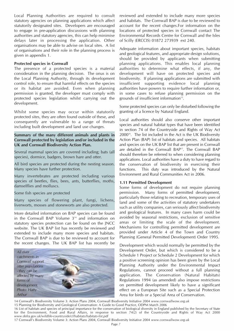
All rivercatchments inCornwall supportotter populations- they can beaffected by manyforms ofdevelopment. Photo: HattyArthur

2.1 Guiding principles for developers
By following the principles outlined here, developments can be both profitable and enhance the naturalenvironment for the benefit of wildlife and local communities.
Summary of guiding principles for protecting and enhancing biodiversity and geological conservation throughdevelopment control
• View biodiversity and geodiversity as an opportunity not a constraint Where wildlife is successfully incorporated into the design of a development it can be an asset to the localcommunity. Houses close to greenspace often command higher market value than houses further away19. Local communities are less likely to object to development proposals that account for the needs of wildlife.
• Access ecological and geological expertiseAssessing the likely ecological impacts of a development is often complex so employing an ecological orenvironmental consultant is likely to be cost effective. Pre-application discussion with relevant agencies andorganisations (see appendix 1) will ensure all issues are considered before an application is submitted and helpprevent delays.
• Surveys and Information Gathering Adequate survey information must be gathered before submitting a planning application. The information shouldthen be used to inform the design of the development from the earliest stage. Insufficient information cansignificantly delay decision making18.
• Avoidance, Mitigation and CompensationEcological or environmental consultants can advise on avoiding negative impacts on biodiversity and geodiversitythrough careful site design. Where negative impacts are unavoidable it may be possible to minimise the impactsthrough mitigation measures. Where mitigation alone is insufficient, it may be possible to use compensatorymeasures to off-set harm. Compensation is the least favoured option.
• Enhancement It is likely that there will be opportunities to provide new benefits on all development sites. For example, retainedhabitats can be extended and enhanced, bird and bat boxes and access can be designed into new buildings, orhabitats once found on the site can be re-created.
Page 8
18. Planning for Biodiversity and Geological Conservation: A Guide to Good Practice, ODPM March 200619. Does money grow on trees?, Cabe Space March 2005 www.cabe.org.uk
2 The Development Process
Bats are frequently affectedby development,
particularly buildingconversion.
Photo: Steve Marshall

2.2 The development control process
The aim of planning decisions should be to prevent harm to, and enhance biodiversity and geological conservationinterests.
Figure 1- How biodiversity and geological conservation should be considered in planning decisions in line withPPS 9
*Up-to-date information and ecological expertise will be required to assess this#Planning Officers will often be able to provide information on the availability of alternative sites
Page 9
Planning permissionmay be refused onnature conservationgrounds
Gather information onthe site andcommissionappropriate surveys.
Don’t know
Yes
Yes
No
Can analternative sitebe used? #
No
Is the development located on a sitewhere it will cause little or no harmto biodiversity or geologicalconservation interests*
Put mitigationmeasures in place - arethese satisfactory? *
YesNo
No
Seek compensationmeasures - are thesesatisfactory? *Yes
Proceed withapplication
Include enhancementmeasures to ensure a net gainfor biodiversity and wherenecessary geodiversity
Preferred option
2nd best option
Least preferredoption

2.3 Stages in the process
Stage 1: Surveys and information gathering - Before acquiring land with development potential, commissioningdesigns or submitting a planning application
Habitat and species surveysWhere a site contains areas of habitat, wildlife potential or geological features, it will be necessary for the developerto gather information to assess the biodiversity value of the site and the immediate surrounding area. Surveys needto be carried out at the earliest possible stage to inform the design of developments and incorporate biodiversity andgeodiversity features in line with PPS 9, this may prevent costly delays later.
Advanced survey information on the presence of protected species and habitats, linked to any required mitigation orcompensatory measures, will help avoid infringements of national and international law, help satisfy the legalrequirements of both the EIA and Conservation (Natural Habitats) Regulations (as amended) and form the basis of asubsequent licence application, if required (PPS 9 Guide to Good Practice- ODPM).
The checklist opposite summarises the most likely circumstances where surveys and assessments would be neededand gives details of where to get further information.
Page 10
The Environmental Records Centre for Cornwall and the Isles of Scilly (ERCCIS) holds a huge volume of data onCornwall’s habitats and species.

Page 11
20. Natural England's ‘Nature on the map’ website www.natureonthemap.org.uk
CHECKLIST
Any of the developments listed below could have a negative impact on habitats and species and/or geodiversityinterests. Surveys and assessments may be required prior to submission of a planning application.
Any proposed development which would involve:Removal of all or part of a Cornish hedge or hedgerow Tree works (felling or lopping) of large trees, old or veteran trees and trees with holes, cracks or splitsRemoval of scrubConversion of barns, farmhouses and other old buildingsLoft conversion or other modification to existing roof spaces or re-roofing Building demolitionInfilling of or modification to mine shafts, adits, caves, culverts, cellars, ice houses or similar underground structuresWorks in or adjacent to watercourses, ponds or other wetland features
OR any proposed development which would be within or likely to affect:A Special Area of Conservation (SAC)20
A Special Protection Area (SPA)20
A National Nature Reserve (NNR)20
A Site of Special Scientific Interest (SSSI)20
A County Wildlife Site (formerly CTNC site) (contact ERCCIS)A County Geological Site (formerly RIGS site) (contact ERCCIS)A Local Nature Reserve (LNR)20
The Cornish Mining World heritage siteAny other site supporting a BAP priority habitat (contact ERCCIS):
Cornish hedge or hedgerowCoastal habitatsAcid grassland & lowland meadowsHeathlandPonds/wetlandWoodland
Traditional orchardsAny site with a protected species record or likely to support a protected species (an ecological consultant can advise)Any site reported by local people or wildlife groups to support a protected species Any site within 30 m of a badger record (contact ERCCIS)Any site supporting or likely to support a BAP priority species- some BAP species are also protected species (contact ERCCIS)Quarry sites and old mine sites
ERCCIS contact details:Five Acres, Allet, Truro, Cornwall, TR4 9DJ Phone: 01872 273939 ext. 240.Fax: 01872 225476 e-mail: [email protected]: www.erccis.co.uk

Validation of planning applicationsIf an application for a development affected by the above list is submitted without sufficient survey information orassessment then the local planning authority is entitled to ask for more information and may refuse planningpermission due to a lack of information21.
Ecological expertiseEmploying an ecological or environmental consultant is likely to prove cost effective in the long term. Consultantscan be contacted through the yellow pages (under Environmental consultants) and through internet directories22. Costswill vary depending on the scale and location of the work proposed, but an initial simple inspection for protectedspecies can cost relatively little. The Environmental Record Centre for Cornwall and the Isles of Scilly (ERCCIS) (seeappendix 1), has contact details for wildlife recording groups who may be able to help.
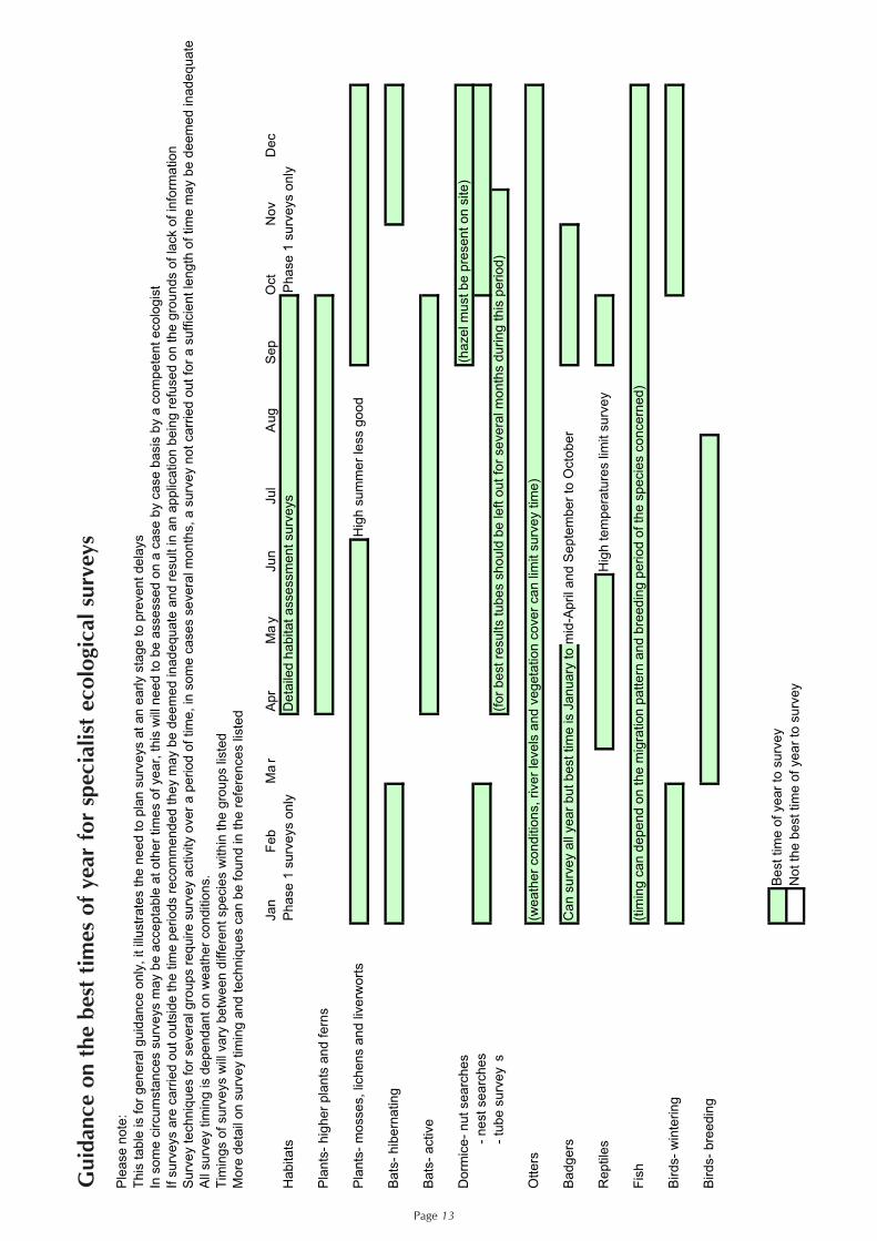
Timing of ecological surveysAn extended Phase 1 habitat survey by a competent ecologist will identify important ecological and geologicalfeatures on the site and its immediate surrounding area, and determine the need for further detailed species surveys.The level of survey data needed and the time taken to collect it will vary according to the size of the developmentand the habitats and species concerned. There are certain times of year when surveys are best conducted for differentspecies and this needs to be taken into account, see table below.
Tree surveys and developmentLarger developments often require a tree survey which follows BS5837:2005. Tree surveys concentrate on the healthand amenity value of trees rather than their biodiversity importance. Old trees and those with cracks, splits, liftedbark and rot holes can be very valuable to wildlife including protected species such as bats and barn owls. It isrecommended that the tree survey and ecological survey are considered together to ensure that trees of importanceto wildlife and trees of high visual amenity and landscape value are retained as part of a development.
Page 12
21. Planning for Biodiversity and Geological Conservation: A Guide to Good Practice ODPM March 200622. Internet directory of Environmental Consultants www.endsdirectory.com and and www.ieem.org.uk/Home.htm
Reptiles on the A30 development site were carefully trapped and moved to ensure they were not injuredduring construction work. Photo: Cornwall Environmental Consultants
Page 13
Ple
ase
no
te:
Th
is t
ab
le is f
or
ge
ne
ral g
uid
an
ce
on
ly,
it illu
str
ate
s t
he
ne
ed
to
pla
n s
urv
eys a
t a
n e
arly s
tag
e t
o p
reve
nt
de
lays
In s
om
e c
ircu
msta
nce
s s
urv
eys m
ay b
e a
cce
pta
ble
at
oth
er
tim
es o
f ye
ar,
th
is w
ill n
ee
d t
o b
e a
sse
sse
d o
n a
ca
se
by c
ase b
asis
by a
co
mpe
ten
t e
colo
gis
t
If s
urv
eys a
re c
arr
ied
ou
t o
uts
ide
th
e t
ime
pe
rio
ds r
eco
mm
en
de
d t
he
y m
ay b
e d
ee
me
d in
ad
eq
ua
te a
nd
re
su
lt in
an
ap
plic
atio
n b
ein
g r
efu
sed
on
th
e g
rou
nd
s o
f la
ck o
f in
form
atio
n
Su
rve
y t
ech
niq
ue
s f
or
se
ve
ral g
rou
ps r
eq
uire
su
rve
y a
ctivity o
ve
r a
pe
rio
d o
f tim
e,
in s
om
e c
ase
s s
eve
ral m
on
ths,
a s
urv
ey n
ot
ca
rrie
d o
ut
for
a s
uff
icie
nt
len
gth
of
tim
e m
ay b
e d
ee
med
in
ad
eq
ua
te
All
su
rve
y t
imin
g is d
ep
en
da
nt
on
we
ath
er
co
nd
itio
ns.
Tim
ing
s o
f su
rve
ys w
ill v
ary
be
twe
en
diffe
ren
t sp
ecie
s w
ith
in t
he
gro
up
s lis
ted
Mo
re d
eta
il o
n s
urv
ey t
imin
g a
nd
te
ch
niq
ue
s c
an
be
fo
un
d in
th
e r
efe
ren
ce
s lis
ted
Ja
nF
eb
Ma
rA
pr
Ma
yJu
nJu
lA
ug
Sep
Oct
No
vD
ec
Ha
bita
tsP
ha
se
1 s
urv
eys o
nly
De
taile
d h
ab
ita
t a
sse
ssm
en
t su
rve
ys
Pha
se 1
su
rve
ys o
nly
Pla
nts
- h
igh
er
pla
nts
an
d f
ern
s
Pla
nts
- m
osse
s,
lich
en
s a
nd
liv
erw
ort
sH
igh
su
mm
er
less g
oo
d
Ba
ts-
hib
ern
atin
g
Ba
ts-
active
Do
rmic
e-
nu
t se
arc
he
s(h
azel m
ust
be
pre
sen
t o
n s
ite
)
-
ne
st
se
arc
he
s
-
tu
be
su
rve
ys
(fo
r b
est
resu
lts t
ub
es s
ho
uld
be
le
ft o
ut
for
severa
l m
on
ths d
urin
g t
his
pe
rio
d)
Ott
ers
(we
ath
er
co
nd
itio
ns,
rive
r le
ve
ls a
nd
ve
ge
tatio
n c
ove
r ca
n lim
it s
urv
ey t
ime
)
Ba
dg
ers
Ca
n s
urv
ey a
ll ye
ar
bu
t b
est
tim
e is J
an
ua
ry t
o m
id-A
pril a
nd
Se
pte
mb
er
to O
cto
be
r
Re
ptile
sH
igh
te
mp
era
ture
s lim
it s
urv
ey
Fis
h(t
imin
g c
an
de
pe
nd
on
th
e m
igra
tio
n p
att
ern
an
d b
ree
din
g p
erio
d o
f th
e s
pecie
s c
on
cern
ed
)
Bird
s-
win
terin
g
Bird
s-
bre
ed
ing
Be
st
tim
e o
f ye
ar
to s
urv
ey
No
t th
e b
est
tim
e o
f ye
ar
to s
urv
ey
Gui
danc
e on
the
bes
t tim
es o
f ye
ar f
or s
peci
alis
t ec
olog
ical
sur
veys

It is the responsibility of the developer and the ecological consultant to ensure that a reasonable amount of surveyeffort has been expended in proportion to the scale of development. There are many sources of information on surveytechniques and timings, these are detailed below.
Further information sources for biodiversity and geodiversity survey workGeneral Development control, local authorities and protected species surveys - Research Report No 479,
2003 English Nature Working with Wildlife. A resource and training pack for the construction industry (C587TP) CIRIA Authors: Newton, J., Williams, C., Nicholson, B., Venables, R. and others 2004 ISBN 0 86017 587 1Guidelines for Environmental Impact Assessment in the united Kingdom, IEEM 2006 www.ieem.net/ecia
Geodiversity Geological conservation-a guide to good practice English Nature 2006 ISBN 1 85716 906 9Amphibians and reptiles
Reptiles: Guidelines for developers, English Nature 2004 ISBN 1 85716 807 0http://naturalengland.twoten.com/naturalenglandshop/docs/IN15.1.pdf Facts about Reptiles, English Nature 1993Herpetofauna Workers’ Manual, Gent, T. and Gibson, S. Eds. 2003 JNCC ISBN 1 86107 4506
Badgers Badgers and Development, English Nature 2002 ISBN 1 85716 614 0http://naturalengland.twoten.com/naturalenglandshop/docs/IN7.5.pdf
Barn owls Barn Owls on Site; A Guide for Developers and Planners, English Nature on behalf of The BarnOwl Trust 2002. http://www.barnowltrust.org.uk/content_images/pdf/BarnOwlsOnSite.pdf
Barn Owls and Major Roads - Barn Owl Trust. http://www.barnowltrust.org.uk/content_images/pdf/ Barn_Owls_and_Major_Roads.pdf
Bats Bats and Trees, Bat Conservation Trust 1997www.bats.org.uk/downloads/Helpline/01.10.12_bats_trees.pdfBats and Buildings, Bat Conservation Trust 2004www.bats.org.uk/downloads/Helpline/Bats_and_Buildings_June04.pdfFocus on bats: discovering their lifestyles and habitats, Natural England 2007 http://naturalengland.twoten.com/naturalenglandshop/docs/NE23focus_on_bats.pdfBat Mitigation Guidelines, http://naturalengland.twoten.com/NaturalEnglandShop/product.aspx? ProductID=77002188-97f9-45a5-86a6-326a7ea3cd69English Nature 2004 ISBN 1 85716 781 33rd Edition Bat Workers' Manual, Mitchell-Jones, A.J., & McLeish, A.P. Eds., 2004. ISBN 1 86107 558 8 www.jncc.gov.uk/page-2861 Bat Surveys - Good Practice Guidelines, Bat Conservation Trust 2007 ISBN 978 1 872745 99 2 www.bats.org.uk/biodiversity/BatSurveyGuidelines.asp
Dormouse The Dormouse Conservation Handbook, Bright, P., Morris, P. and Mitchell-Jones, T. 2006 (2nd edition). English Nature, Peterborough. Surveying dormice using nest tubes- results and experiences from the South West Dormouse Project, Chanin, P. and Woods, M. English Nature Research Report 527 2003.
Otters Otters and River Habitat Management, The Environment Agency 1993. Out of printInvertebrates Organising surveys to determine site quality for invertebrates- A framework guide for ecologists,
English Nature. 2005. ISBN 1 85716899 2
Environmental Impact Assessment and AppropriateAssessmentSome developments require an EnvironmentalImpact Assessment (EIA) under the Town andCountry Planning Regulations 1999. Even permitteddevelopment that could have a significant impact onconservation interests may require an EIA. If indoubt applicants should initially contact the localplanning authority so that the application may be‘screened’ to determine if an EIA is necessary.
Appropriate assessment is required by law for sitesdesignated as SPA and SAC. Appropriateassessment is also required, as a matter ofGovernment policy, for potential SPAs, candidateSACs and listed Ramsar Sites for the purpose ofconsidering development proposals affectingthem.
Page 14
When essential works needed to be carried out close to a badger sett atRAF Portreath an alternative sett was provided under licence. Photo:
Cornwall Environmental Consultants

Stage 2: Design
Protecting the biodiversity/geodiversity present on the siteIn designing any development, the first step to building in biodiversity and geodiversity is to protect existing key habitats,species and geological features. The approach should be to use survey information to design biodiversity and geodiversityinto new developments as far as possible. Site layout and design should seek to retain existing habitats, ecological featuresand geological interest, giving priority to Biodiversity Action Plan habitats and species where they are present. If thiscannot be achieved at a particular site, is that site the most suitable for the type of development proposed? In some casesseeking an alternative site could be a better option. This section is based on the key principles of PPS 923.
Consideration also needs to be given to natural features just outside the application site which may be affected by thescheme. This is especially necessary where adjacent sites may be designated for their biodiversity or geodiversityvalue, and where a linear habitat such as a water course, Cornish hedge or hedgerow which may act as a wildlifecorridor, will be affected by the development.
Cornish hedges and developmentThe typical Cornish hedge is a stone-faced earth hedgebank often with bushes and trees growing on it. Cornish hedgescan also be of turf construction with little stone facing. Well managed Cornish hedges represent a linked, stable habitatsupporting a wide range of animals and plants. Hedges are also of great landscape, historical and geological importance.
Stage 1 - Surveys and information gatheringThe definition of a hedge used in the Hedgerow Regulations does not accord with all Cornish hedges, since many donot have rows of trees or bushes on them. Many Cornish hedges are very rich in plants and animals and are of highlandscape and historical importance yet are not classed as ‘important’ under the regulations. The Hedge (and Wall)Importance Test (HIT), devised by the Guild of Cornish Hedgers is an alternative which can be applied to all hedges,dry stone walls and hedgerows, including Cornish hedges. For more information on the HIT test seewww.cornishhedges.com
The design stage here should lead clearly and logically from the survey information gathered during Stage 1. Where a site or its surroundings have clear biodiversity value and no steps, or insufficient steps, are taken toreasonably protect this value, then planning permission may be refused.
Stage 2 - Designing in biodiversity/geodiversityProtection - Cornish hedges should be retained and incorporated into the design of developments wherever possible.Where some hedges cannot be retained the HIT test can be used to help assess which hedges should be prioritisedfor retention. Connectivity of hedges is a very important consideration.Mitigation - Where hedge banks and hedgerows are retained as part of a development, provision of adjoining stripsof buffer habitat such as rough grassland or scrub at least 2m wide on each side of the hedge can have a positiveimpact on biodiversity. Compensation - Where it is not possible for all hedges to be retained; equal length(s) of new hedge should be built withinthe development site in compensation. These new hedges (or areas of trees and shrubs if it is not possible to build newhedges) should connect into the retained hedge network and other areas of retained semi-natural habitat. All stone andsoil from any removed hedges should be re-used for building the new sections as detailed in the Guild of Cornish Hedgers’Code of Good Practice for Cornish Hedges available at www.cornishhedges.com. Where new material is required itshould match the stone type of the original hedges.Enhancement - Enhancements to existing hedges can include repair of damaged sections, building new sections tolink to other hedges on site and on neighbouring sites and bringing neglected hedges back into active management.Any damaged retained hedge sections should be repaired using stone reclaimed from the site wherever possible tomatch the existing hedge pattern.
Stage 3 - Construction stageHedges that are being retained as part of a development, or new hedges that are created should be protected usingfencing during construction works. Where Cornish hedges are to be repaired as part of a development, or new hedgescreated, techniques should follow the Guild of Cornish Hedgers’ Code of Good Practice for Cornish Hedges.
Stage 4 - Monitoring and managementManagement options for retained and new Cornish hedges should form part of an overall management plan agreedwith the developer.
Further information Additional information on Cornish hedges and development is available on the Guild of Cornish Hedgers websitedetailed above.
Page 1523. Planning Policy Statement 9: Biodiversity and Geological Conservation, ODPM August 2005

Mitigating harm caused by the developmentEvery effort should be made to avoid harm to existing habitats, species and geological features through designmeasures. Where this is not possible, reasonable alternative sites should be considered. If there are no alternativesites it may still be possible to minimise potentially damaging impacts through mitigation measures. In such casesadequate mitigation steps should be proposed by the developer and will then normally be the subject of planningconditions or obligations on design, methods or timing of development.
Mitigation measures are used to minimise damaging impacts, they can include, amongst others:
• Timing the development of sites to avoid the breeding seasons of species present • Creating buffer zones between sensitive areas and development areas to reduce disturbance to habitats • Ensuring that new infrastructure such as bridges are built to enable movement of wildlife to continue • Translocation of species from destroyed habitat, to be used only as a last resort and should follow IUCN
guidelines.• A financial contribution to management of nearby existing wildlife sites, through a commuted sum, can be
required where the development could lead to increased pressure on those sites (e.g. noise, light pollution and disturbance through increased amenity use)
For further examples please see the case studies in section 3.
It must, however, be remembered that mitigation stillentails harm of some form. Where a site or itssurroundings have clear biodiversity and/or geologicalvalue and the proposed mitigation steps are insufficient toreasonably protect this value, then planning permissionmay be refused on these grounds.
Some operations that affect protected species may requirea Natural England licence before work can commence.Wildlife licences may be needed even after planningpermissions have been granted. Natural England'sWildlife management and Licensing Service in Bristolwill provide advice on licence application procedures,but a qualified Ecological Consultant will usually beneeded to submit an application. For further informationon licensing issues see www.naturalengland.org.uk/conservation/wildlife-management-licensing .
Compensating for habitat lossWhere damage is unavoidable, alternative sites are notavailable and damage will still occur in spite ofmitigation, loss to biodiversity can in some cases becompensated for by creating new habitat in replacementeither on or off-site. Some examples of how this can bedone are given in Table 2 below.
Where this is appropriate then the steps required will beproposed by the developer and will then normally be thesubject of planning conditions or planning obligations(see Stage 4: Monitoring, Management and Enforcement,below), for example to ensure re-creation of habitat in acertain place by a certain time. An arrangement can bemade for the developer to provide money for habitatcreation and maintenance, either on or off-site.
Page 16
Small scale enhancement like this barn owl box on a South West Water building at Portscatho can be easily and inexpensivelyincorporated into the design of a development. Photo: Tim Warne
Established habitat usually acquires biodiversity valueover a very long period of time as its ecology diversifiesand changes. Artificially recreated habitat will thereforeusually be greatly inferior to established habitat forexample, newly planted woodland is of lesser value thanexisting ancient woodland. For this reason compensationis the least favoured option. There are only very limitedcircumstances where this loss is justified. If significantharm cannot be prevented, adequately mitigated against,or compensated for, planning permission could berefused on nature conservation grounds.
Enhancing the biodiversity/geodiversity of the siteDevelopments should aim to enhance biodiversity andgeological conservation interests, regardless of thecurrent status of the site, in line with PPS 9. This willensure that it contributes to the wider aims ofenhancing urban and rural areas overall, and delivery ofthe BAP and GAP. Enhancement should be appropriateto the scale of the development. Options include design
measures for individual buildings through to largerdevelopment sites. Major developments can have thegreatest impact, but also offer the greatest opportunitiesfor biodiversity and geological conservation.
Developers should look to design in opportunities toimprove habitats for biodiversity conservation, and toincrease the overall quality of the development byenhancing existing habitats and geological features orcreating new areas appropriate to the wider landscapecontext. This should be in addition to any necessarymitigation or compensation. The draft south-west RegionalSpatial Strategy24 includes targets for re-creation of BAPhabitats and Naturemap25, a tool for targeting large-scalehabitat creation schemes. The Cornwall and Isles of ScillyLandscape Character study 2005-7 available atwww.cornwall-landscape.gov.uk gives information onwhich habitats are important in particular areas. Togetherthe BAP targets, Cornwall Landscape Character study andNaturemap can inform proposals to create wildlife habitats.
Page 17
When this bridge was strengthened an otter ledge was incorporated to allow passage during highriver flows and stop otters attempting to cross the road. Photo: Kate Stokes
24. The SW Regional Spatial Strategy www.southwest-ra.gov.uk go to SWRA then Regional Spatial Strategy planning-RSS25. The SW Nature Map www.swenvo.org.uk/nature_map/nature_map.asp

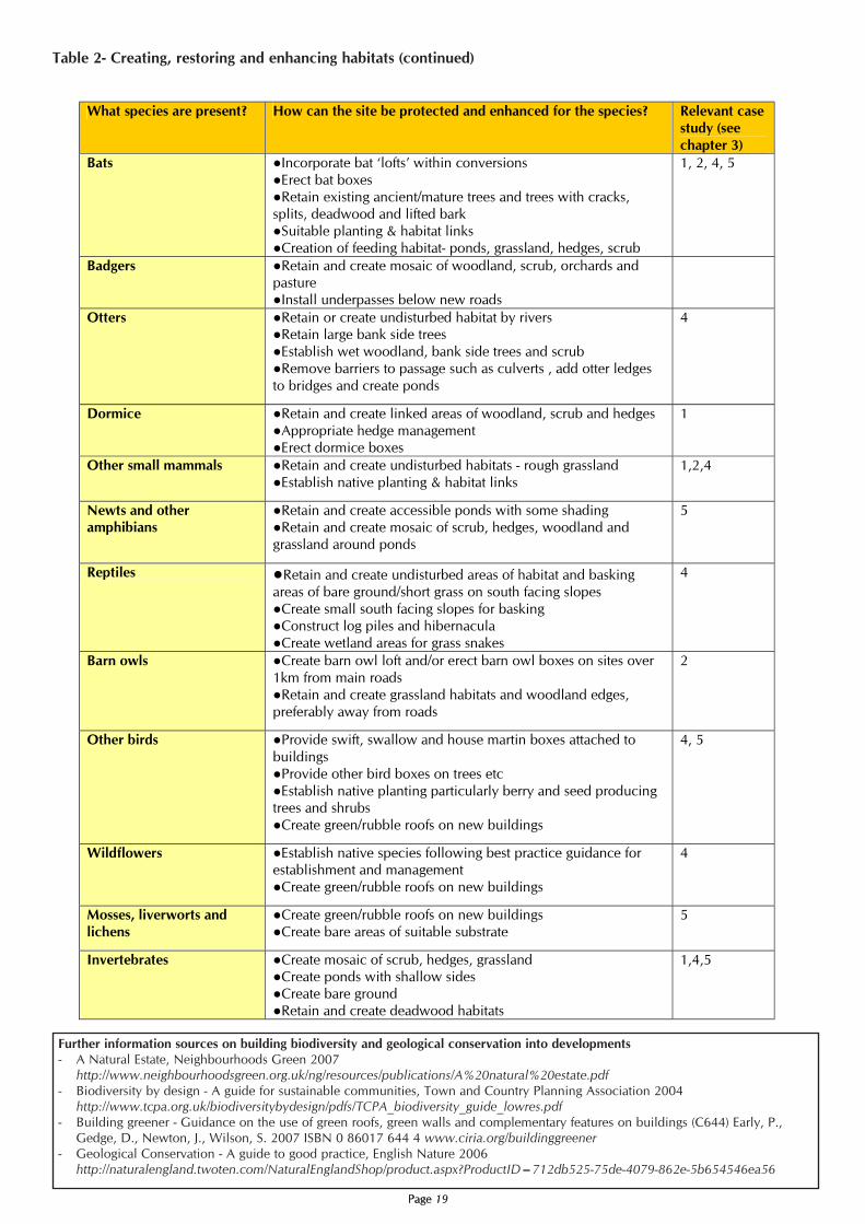
Table 2 - Creating, restoring and enhancing habitats
The table below gives examples of the kinds of enhancement that can be carried out. Existing habitats can be used toinform the choice.
Page 18
Page 19Page 19
What species are present? How can the site be protected and enhanced for the species? Relevant case
study (see
chapter 3)
Bats Incorporate bat ‘lofts’ within conversions
Erect bat boxes
Retain existing ancient/mature trees and trees with cracks,
splits, deadwood and lifted bark
Suitable planting & habitat links
Creation of feeding habitat- ponds, grassland, hedges, scrub
1, 2, 4, 5
Badgers Retain and create mosaic of woodland, scrub, orchards and pasture
Install underpasses below new roads
Otters Retain or create undisturbed habitat by rivers Retain large bank side trees
Establish wet woodland, bank side trees and scrub
Remove barriers to passage such as culverts , add otter ledges
to bridges and create ponds
4
Dormice Retain and create linked areas of woodland, scrub and hedges
Appropriate hedge management
Erect dormice boxes
1
Other small mammals Retain and create undisturbed habitats - rough grassland
Establish native planting & habitat links
1,2,4
Newts and other amphibians
Retain and create accessible ponds with some shading
Retain and create mosaic of scrub, hedges, woodland and
grassland around ponds
5
Reptiles Retain and create undisturbed areas of habitat and basking
areas of bare ground/short grass on south facing slopes
Create small south facing slopes for basking Construct log piles and hibernacula
Create wetland areas for grass snakes
4
Barn owls Create barn owl loft and/or erect barn owl boxes on sites over
1km from main roads
Retain and create grassland habitats and woodland edges,
preferably away from roads
2
Other birds Provide swift, swallow and house martin boxes attached to
buildings
Provide other bird boxes on trees etc
Establish native planting particularly berry and seed producing trees and shrubs
Create green/rubble roofs on new buildings
4, 5
Wildflowers Establish native species following best practice guidance for establishment and management
Create green/rubble roofs on new buildings
4
Mosses, liverworts and
lichens
Create green/rubble roofs on new buildings
Create bare areas of suitable substrate
5
Invertebrates Create mosaic of scrub, hedges, grassland Create ponds with shallow sides
Create bare ground
Retain and create deadwood habitats
1,4,5
Table 2- Creating, restoring and enhancing habitats (continued)
Further information sources on building biodiversity and geological conservation into developments- A Natural Estate, Neighbourhoods Green 2007
http://www.neighbourhoodsgreen.org.uk/ng/resources/publications/A%20natural%20estate.pdf- Biodiversity by design - A guide for sustainable communities, Town and Country Planning Association 2004
http://www.tcpa.org.uk/biodiversitybydesign/pdfs/TCPA_biodiversity_guide_lowres.pdf- Building greener - Guidance on the use of green roofs, green walls and complementary features on buildings (C644) Early, P.,
Gedge, D., Newton, J., Wilson, S. 2007 ISBN 0 86017 644 4 www.ciria.org/buildinggreener- Geological Conservation - A guide to good practice, English Nature 2006
http://naturalengland.twoten.com/NaturalEnglandShop/product.aspx?ProductID=712db525-75de-4079-862e-5b654546ea56

Regardless of how effectively the biodiversity andgeodiversity values of the site have been identified andconsidered through the project planning and designstages, there remains a risk that environmental impactswill occur during the construction phase unless specificmeasures are taken to prevent or minimise this. Also, itis not acceptable to promise an enhanced localenvironment once the development has beencompleted if this involves avoidable impacts duringconstruction.
Pollution legislationMany of the activities that take place on a demolition orconstruction site have the potential to cause pollution ofair or water and re-mobilisation of soil contaminants,including invasive species such as Japanese knotweed(see table below). Such activities are subject to their ownlegislation, regardless of the benefit of planningpermission. These include the following:
Water Resources Act 1991Environmental Protection Act 1990Wildlife and Countryside Act 1981(as amended)
The Environment Agency has a range of informationleaflets concerning pollution prevention, many of whichare relevant to construction activities - e.g. PollutionPrevention Guidance Note 5: Works in, near or liable toaffect watercourses. Further information can be found via:www.environment-agency.gov.uk
Construction Method StatementDepending upon the scale and complexity of theproposed development, it may be appropriate to producea Construction Method Statement, detailing methods ofworking to prevent or minimise impacts arising from site
clearance, demolition and construction. This mustcontain adequate information to provide reassurance thatimpacts can be controlled. It should include at least thefollowing:
Details of site location and all plant and machinery tobe used on siteDetails of all materials to be used on siteLikely or intended access routes into and around thesite – these aren’t necessarily required on planningapplications, but can result in impacts if notconsideredTemporary works designs – e.g. for structural repairDetails of site offices, compounds and othertemporary structuresDetails of service provisions both temporary andpermanentMaterials storage provisions and re-fuellingarrangementsExclusion areas to protect trees and other habitat andlandscape featuresDetails of how invasive species such as Japanese knotweed, if present, will be controlled and managedDetails of the procedure for dealing with theunexpected discovery of a protected species oncework has commenced,e.g. stop work and seek advice
Environmental Clerk of Works (ECW)For large developments the use of an ECW is often usefulto ensure that attention to environmental mattersbecomes an ongoing process. As well as ensuring thatany and all protective measures remain intact at all times,they could also provide training to other site staff in, forexample, emergency spill procedures or flooding. Insome cases supporting specialists may be required, suchas an arboriculturalist.
Page 20
Cornish hedges link other habitats together and support a wide range of plants and animals. Photo: Cheryl Marriott
Stage 3: Construction – All activities relating to site clearance and building phases

Table 3- Frequent impacts related to construction and how these can be avoided
Page 21

Developers should monitor and manage enhancement,mitigation and compensation measures. A competentecological consultant will be able to devise a monitoringscheme appropriate to the scale of the development andimplement it for an agreed time period. Monitoring thesuccess of these measures gives information that can beused to assess whether the development needs modifyingor if further mitigation or compensation is needed.
If information on the success of mitigation andcompensation is made available to conservationorganisations through the Environmental Records Centrefor Cornwall and the Isles of Scilly (ERCCIS) it allowseveryone to learn from the developer’s experience andinform future projects. Monitoring is likely to be essentialas part of a European protected species licence.
Planning conditions and planning obligations It is good practice to address biodiversity and geologicalconservation as completely as possible within the designof the development approved. However, it will often benecessary to secure further matters through theimposition of conditions and/or obligations.
Planning conditions mitigate identified harm that wouldotherwise result in the refusal of the application. Planningconditions achieve this in several ways on thedevelopment site including:
• A developer monitoring a site during and postconstruction to ascertain any effects on wildlife,especially protected species • Ensuring that the development process continues to
comply with PPS 9 after planning permission has beengranted, for example by requiring an ecological watchingbrief• The monitoring of retained features and of new orenhanced habitats to gauge their success • Restricting or regulating the development in someway, for example by requiring certain operations to becarried out at set times of the year• Requiring works to be carried out, construction of abarn owl nesting box as part of a barn conversion orhabitat enhancement for example.• Requiring schemes or further details such as a detailedlandscaping scheme to be submitted for approval to theLocal Planning Authority.• Requiring the incorporation of existingecological/geological features such as trees, hedges andmine waste dumps and their protection duringconstruction.• Limiting the duration of all or part of the development• Requiring appropriate management and maintenanceafter construction to benefit biodiversity and geodiversity.
Conditions can only be used where they are: necessary,relevant to planning, relevant to the development to bepermitted, enforceable, precise and reasonable26.
Planning obligations are an agreement between theplanning authority and the developer (those with a legalinterest in the land). They are sometimes used to addressbiodiversity or geological conservation issues,particularly where enhancement or mitigation measuresare to be carried out outside the application site.
Page 22
26. The use of conditions in planning permissions, DEFRA circular 11/95
Stage 4: Monitoring, management and enforcement - Once planning permission has been given
A survey showed that bats were using this barn, which was subsequently converted under a protected species licence See overpage. Photo: Steve Marshall

Planning obligations are usually used where financialpayments or on-going management are required toaddress biodiversity or geological conservation concerns,they should be necessary to make an otherwiseunacceptable development acceptable. Planningobligations should also be reasonable, serve a planningpurpose and relate to the proposed development in scaleand kind27. Section 106 agreements are the usual way offormalising planning obligations.
Examples of the use of planning obligations:
• Provision of access and interpretation facilities for an area of biodiversity interest or a geological feature
• Provision of new habitats or geological exposures• Off-site monitoring of the hydrological effects of
development• Financial provisions such as a commuted sum for
management to cover long-term maintenance costs• Ongoing management of new or improved habitats
after the initial after-care or landscaping maintenance period, possibly through a 5-year (or longer) management plan with the developer
• Agreement with the local parish council, conservationgroup, the relevant housing association, the local authority or local residents group, where that group may be prepared to take on management responsibility.
In addition to planning conditions and obligations,informatives may be attached to planning applicationdecision notices. Informatives guide the applicant toother consents that might be necessary, such as aEuropean Protected Species licence issued by NaturalEngland. Informatives are not a statutory part of thedecision notice but should be carefully considered asthey may assist in ensuring a development is properlycarried out.
Planning Gain SupplementAt the time of writing the Government has consulted onproposals to introduce a planning gain supplement. Thiswould use some of the money associated with increasedland values for land with full planning permission toprovide site infrastructure. In future this may be the mainmechanism for securing contributions from developers toachieve biodiversity objectives. Once the Governmenthas made a decision on this we recommend that LPAsmeet with relevant nature conservation bodies to agreethe best approach.
Development plan monitoringLocal Planning Authorities are required to monitor theeffectiveness of their plans and policies. It is useful fordevelopers to provide relevant information such as thearea of BAP habitats that will be lost, restored, maintainedand created as part of a development. The LocalPlanning Authority can provide guidance on theirmonitoring requirements.
Page 23
27. Planning Obligations Circular 05/2005, ODPM 2005 www.communities.gov.uk/publications/planningandbuilding/circularplanningobligations
This barn was converted under a protected species licence. Monitoring post-conversion has shown that bats continue to use thebuilding. Photo: Steve Marshall

Page 24
3 Case Studies

Page 25

Page 26

Page 27

Page 28
Page 29

Page 30

Page 31

Page 32

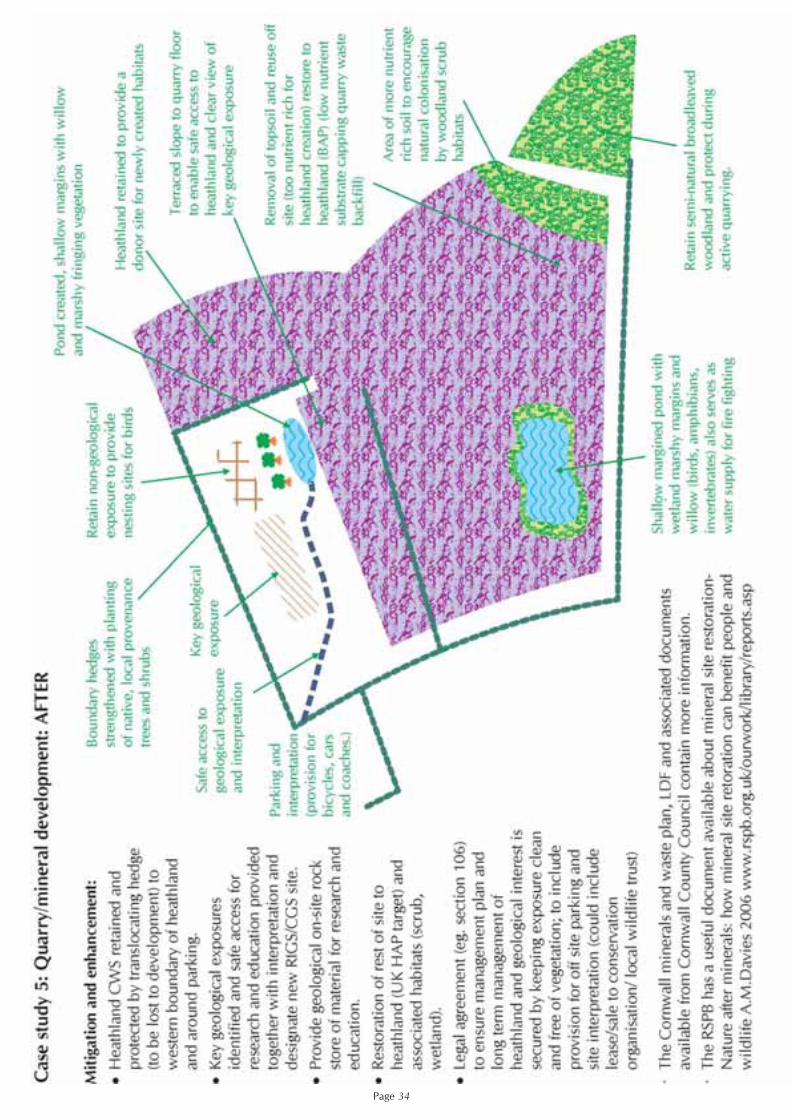
Page 33
Page 34

Appendix 1. Organisation contacts and their role in planning.
Page 35
Organisation Role in Planning Process Contact DetailsNatural England(Local Team Office)
Has a statutory role as consultee or advisor onprotected species, development affectingstatutory sites and ecological/geologicalaspects of EIA
Natural England: Cornwall, Devon and Isles ofScilly Team, Pydar House, Pydar Street, Truro, TR1 1XU. 01872 [email protected]
Natural England(Licensing Section, Bristol)
Has a statutory role to issue and adviseupon licences for legally protected speciesfor the purposes of development
Natural England: Wildlife Management andLicensing Service, Burghill Road, Westbury-on-Trym, Bristol, BS10 6NJ0845 601 4523 [email protected]
Environment Agency Has a statutory role as a consultee oradvisor on sustainable development
Environment Agency, Sir John Moore House,Victoria Square, Bodmin, PL31 [email protected]
Cornwall County Council Minerals and waste planning authority andhighway authority. Historic EnvironmentService: pre-application advice and generalguidance on archaeology and historiclandscapes; advice provided to LPAs onimpact and mitigation. Living EnvironmentService: General guidance/ pre applicationadvice for trees and ecology onapplications to be determined by theCounty Council
Cornwall County CouncilLiving Environment ServiceSt.Clement BuildingOld County HallTruroTR1 3AY01872 322000
Caradon District Council Local Planning Authority for allapplications except minerals and wasteand County Council developments in the Caradon District
Caradon DC, Luxstowe HouseLiskeardPL14 3DZ01579 341000
Carrick District Council Local Planning Authority for allapplications except minerals and wasteand County Council developments in thedistrict
Planning and Leisure Services Carrick District Council, Carrick HousePydar Street, Truro TR1 1EB01872 224400
Kerrier District Council Local Planning Authority for allapplications except minerals and wasteand County Council developments in theKerrier District
Kerrier DC, Council OfficesDolcoath Avenue, CamborneTR14 8SX01209 614000
North Cornwall District Council Local Planning Authority for allapplications except minerals and wasteCounty Council developments in the NorthCornwall District
Development Control3-5 Barn LaneBodmin PL31 1LZ01208 893333
Restormel Borough Council Local Planning Authority for allapplications except minerals and wasteand County Council developments in theRestormel Borough
Planning and Building ControlRestormel Borough CouncilPenwinnick Road, St.Austell PL25 5DR01726 223300
Penwith District Council Local Planning Authority for allapplications except minerals and wasteand County Council developments in thePenwith District
Planning and Building ControlPenwith District CouncilSt Clare, Penzance TR18 3Q01736 362341
Cornwall Wildlife Trust Non-statutory consultee to planningapplications affecting County Wildlife Sitesand for major developments
Five Acres, Allet, Truro, TR4 9DJ01872 273939 [email protected]
RSPB Non-statutory consultee to planningapplications affecting RSPB reserves andmajor developments likely to impact onareas important for birds.
The Manor Office, MarazionPenzanceTR17 0EF01736 711682
RIGS Group (Geology) Non-statutory consultee to planningapplications affecting County GeologySites (RIGS) and minerals and wasteplanning applications
Five Acres, Allet, Truro TR4 9DJ01872 273939www.cornwallgeology.org.uk
Cornwall AONB Team Advise on development proposals that arepotentially damaging to the character ofthe Cornwall AONB
Cornwall AONB unit, Fal BuildingTreyew Road, TruroTR1 3AY 01872 [email protected]
Tamar Valley AONB unit Advise on development proposals that arepotentially damaging to the character ofthe Tamar AONB
Cotehele Quay, Cothele, St Domininck, Saltash,PL12 6TA 01579 [email protected]
Environmental Records Centre forCornwall and the Isles of Scilly
Collates, manages and disseminatesenvironmental information, Five Acres,
Allet, Truro TR14 9BL01872 273939 ext 240.ww.erccis.co.uk
Forestry Commission Consultee on any development that iswithin, or will potentially have an effecton, ancient woodland
Mamhead Castle, Mamhead, Nr Exeter, Devon, EX6 8HD. 01626 890666