Bike Lanes and Safety Improvements - Welcome to...
44
HARLEM BIKE NETWORK Bike Lanes and Safety Improvements Presented to Community Board 10 on June 13,2017 Updated on September 12, 2017 1
Transcript of Bike Lanes and Safety Improvements - Welcome to...

HARLEM BIKE NETWORK Bike Lanes and Safety Improvements
Presented to Community Board 10 on June 13,2017
Updated on September 12, 2017
1

PRESENTATION OVERVIEW
Harlem Bike Network Expansion
1. Overview/context City is growing
Pressure on transportation Bike adds transportation mode alternative
Number of jobs Number of tourists
Citi Bike
Safety (highlights – fatalities on Amsterdam Ave, bike lane before, after data)
VZ HRBAP SA
What we heard from community 2. Projects 3. Process
Emphasize what we’ve done What’s next
Review of Background
and Proposals 110th St, 111th St
126th St, 128th St
5th Ave
Update: Additional Outreach
and Follow Up Resurfacing
Walk Through
Partnerships
Street Ambassador Deployments

1 Background

NYC MOBILITY
Background
Recent Travel Trends (2010-2015)
As the city grows, there is higher demand
on the transportation system and people
are increasingly turning to mass transit,
FHV carpooling, and cycling.
New York City Mobility Report 2015. Bike Data 2010-2014 . Other Data 2010-2015
+370,000 New York City residents
+520,000 new jobs
+20%
+10%
+80%
growth tourists
growth in subway trips
growth in daily cycling trips

5
BIKE NETWORK – Citi Bike
Recent Trends
Total Number of Citi Bike Trips in NYC:
2016 - 14 million trips
2015 - 10 million trips
70,000 trips per
day
Staten
Island Ferry
Boro
(green)
Taxi
Citi Bike Program Areas
Background
Citi Bike regularly serves over
70,000 trips per day
more than

PROJECT AREA
110th St (Manhattan Ave to Central Park W)
1,401 weekend
637 weekday
110th St (5th Ave to Lenox Ave)
1,110 weekend
725 weekday
5th Ave (112th to 115th St)
422 weekend
408 weekday
125 ST
5 A
VE
110 ST
Marcus Garvey
Park
119 ST
120 ST
1 AV
E
Am
ster
dam
Ave
126 ST
128 ST
135 ST
St.
Nic
ho
las
Pa
rk
Riv
ersi
de
Pa
rk
Thomas Jefferson
Park
Hu
dso
n R
iver
Gre
enw
ay
110 ST
Fre
der
ick
Do
ugl
ass
Blv
d
AC
P J
r B
lvd
St N
ich
ola
s A
ve
106 ST
CB 9
CB 10
CB 11 CB 7
96 ST
2 A
VE
155 ST
Bra
dh
urs
t A
ve
145 ST
5 A
VE A
CP
Jr
Blv
d
165 ST
Counts
1
1
2
2
3 3
125th St (Amsterdam Ave to Morningside Ave)
436 weekend
450 weekday
1st Ave (124th St & RFK Bridge)
593 weekend
704 weekday
4
5
6
4 5
6
ACP Blvd (136th St & 137th St)
340 weekend
217 weekday
Minimal bicycle infrastructure in CB 9, 10, and 11
Heavily used routes
Background

125 ST
5 A
VE
110 ST
111ST
Marcus Garvey
Park
2 A
VE
119 ST
120 ST
1 A
VE
Am
ste
rdam
Ave
126 ST
128 ST
130 ST
St. N
ich
ola
s P
ark
Riv
ersi
de
Pa
rk
Thomas Jefferson
Park
Hu
dso
n R
iver
Gre
enw
ay
110 ST
Fre
de
rick
Do
ugl
ass
Blv
d
AC
P J
r B
lvd
St N
ich
ola
s A
ve
PROJECT AREA – Citi Bike Expansion Area (110th St to 130th St)
Trips taken Quarter 4 2016
37,052
120 ST
Existing
Planned
Background
Citi Bike provides a new transportation option and increases neighborhood biking that • Is useful for short trips – most Citi Bike trips
are between 6 and 9 min (average trip is under 14 minutes)
• Can be faster and more convenient than taking a bus
• Can be used to get to subway stations for efficient multi-modal trips
• Makes biking an easy option for those who don’t own or have a place to store a bike
Is an affordable option – unlimited 45 min trips for $15/month (with an annual membership, discounted memberships are $5/month)
2 Community Outreach

10
SAFETY – Vision Zero
Goal: Reduce preventable deaths and injuries
through improved engineering, education,
and enforcement
Outreach Process: Public workshops
Interactive Web Portal
Borough Action Plans
Roll-out of safety initiatives
Outcome: Release of Borough Action Plans
Continue roll out of safety initiatives
Three years of declining fatalities (2014-17)
Reduce preventable deaths and injuries through improved engineering, education, and enforcement
Protected bicycle lanes have been shown to reduce injuries to….
• pedestrians by 22%
• motor vehicle occupants by 25%
Redesigns of high-crash corridors that
include bicycle facilities can improve
safety for all road users
Outreach
Program Outreach Outcome
Pedestrian KSI crashes on streets with
bike lanes were ~40% less deadly

CITI BIKE
Goal: DOT and Motivate work with community to
find best locations for stations in
neighborhood, and expansion roll out
Outreach Process: 2015 – Present
Community workshops
Public web portal
Meeting with community representatives,
institutions, and BIDs
Outcome: 2016 - draft plan with location of Citi Bike
stations identified through community
engagement
2017 expansion of Citi Bike in CB 9, 10 and
11 (110th St to 130th St)
Outreach

12
HARLEM RIVER BRIDGES ACCESS PLAN
Goal: Increase and improve pedestrian and
bicycle safety and mobility between
Manhattan and the Bronx across
13 Harlem River Bridges
Outreach Process: 12 workshops
200 surveys
Outcome: In Fall 2017 DOT will release report
highlighting 37 priority projects
Roll out of projects
Outreach

Goal: Further evaluate pedestrian and bike
potential connections based on
community’s feedback.
Outreach Process: Follow up to HRBAP, collection of
additional community feedback, Street
Ambassadors deployed to
12 deployments, 8 locations
Outcome: 49% of surveyed ride bike in NYC
78% of surveyed have friends or family
who bike in NYC
Almost three times as many people
reported to riding a bike or walking to
parks and green spaces in the
neighborhood compared to driving, or
taken public transit
STREET AMBASSADOR DEPLOYMENT
Locations - Focus on Harlem Community hubs
Outreach
123 people surveyed Map (people bike everywhere) – heat maps Destinations by mode % of people that either bike or know someone that bikes

Goal: Further evaluate pedestrian and bike
potential connections based on
community’s feedback.
Outreach Process: Follow up to HRBAP, collection of
additional community feedback,
Street Ambassadors deployed to
12 deployments, 8 locations
Outcome: Further identified issues and
opportunities for bike infrastructure in
Harlem
STREET AMBASSADORS DEPLOYMENT
Outreach
“I want to start biking next summer and good infrastructure encourages me to do that more.” “Times have changed and we need to share the road.”
“[We need] more bike lanes, better enforcement, and better signage.” Survey Comments

15
DEPARTMENT OF HEALTH - East Harlem Action Centers, Partnership for Healthier Manhattan
Goal: Work with community and DOT to increase bike
education, improve bike infrastructure, enhance
safety to address health inequities
Outreach Process (on-going): Convened East Harlem Biking Coalition (Nov 2016)
Conducted 1:1 conversations about biking with
community partners (Jan-Feb 2017))
Convened organizations to report on trends (March
2017)
Co-hosted El Barrio Bike Bash with community
partners (March 2017, 186 participants)
Outcome: Biking is a great way to get around, improve health
and socialize
Younger generation is excited about biking
Biking is engrained in Latino culture and has a rich
history in East Harlem
Lack of bike infrastructure
Safety concerns
Outreach
Bike Equity Physical Activity Transportation

3 Proposals

155th ST
125th ST
145th ST
162nd ST
Am
ste
rdam
Ave
5th
AV
E
110th ST
111th ST
133th ST
PROJECT GOALS / ROUTE SELECTION
Central Park
Marcus Garvey
Park
2n
d A
ve
119th ST
120th ST
Mo
rnin
gsi
de
Pa
rk
Jack
ie R
ob
inso
n P
ark
St
. Nic
ho
las
Pa
rk
Riv
ersi
de
Pa
rk
St. N
ich
ola
s A
ve
Fre
de
rick
Do
ugl
ass
Blv
d
110th St
1st
Ave
AC
P B
lvd
SAFETY MOBILITY
PUBLIC INPUT
Vision Zero
Citi Bike
Harlem River Bridge Access Plan
Street Ambassadors
Department of Health
Prioritize routes that provide safe and direct connection
to existing network
Create all-ages-friendly routes with connection to green
and recreational spaces
Accommodate Citi Bike expansion
Redesign roadway to reduce on-street injuries and
fatalities for all road users
Address community’s safety concerns
Use wayfinding to direct cyclists to safest routes
10 cyclists killed , 92 cyclists were severely injured in CB 9, 10, 11, between 2010 and 2014
Proposal
Identify and develop projects that:
Incorporate public input
Increase safety for all road users
Create direct, connected bike network that improves mobility and
enhances access to key destinations

125th ST
5th
AV
E 110th ST
111th ST
Marcus Garvey
Park
2n
d A
ve
119th ST
120th ST
1st
Ave
Am
ste
rdam
Ave
126th ST
128th ST
130th ST
111th ST
St. N
ich
ola
s P
ark
Riv
ersi
de
Pa
rk Thomas
Jefferson Park
Hu
dso
n R
iver
Gre
enw
ay
PROJECT AREA
110th St Counts (Manhattan Ave to Central Park W)
1,401 (weekend)
637 (weekday)
Citi Bike Expansion Area
in Upper Manhattan
110th St Counts (5th Ave to Madison Ave)
1,110 (weekend)
725 (weekday)
connection to the Manhattan Waterfront Greenway (west and east side)
southbound bicycle connection from Amsterdam Ave to Columbus Ave
SB connection from Amsterdam Ave to Columbus Ave
126th St/128th St (alternative to 125th St)
Identified as a priority route during
HRBAP workshops and S.A.
deployment
Limited possibilities for direct
routes
Connects to Willis Ave and RFK
5th Ave Strong desire for protected bike lane
identified through S.A. outreach
Excess width encourages speeding and
other unsafe behavior
Serve people traveling south as well as
those traveling north on other streets
110th ST
133rd ST
CB 9
CB 10
CB 11
1
3
2
Proposal
110th/111th St Limited east-west through streets (first
opportunity after 72nd St)
Identified as a priority route during HRBAP
workshops and S.A. deployment
Re-design of W 110th St, and FD Circle
(community safety concerns)
CB 7

PROJECT AREA
155th ST
125th ST
145th ST
162nd ST
Am
ste
rdam
Ave
5th
AV
E
110th ST
111th ST
133th ST
Central Park
Marcus Garvey
Park
2n
d A
ve
119th ST
120th ST
Mo
rnin
gsi
de
Pa
rk
Jack
ie R
ob
inso
n P
ark
St
. Nic
ho
las
Pa
rk
Riv
ersi
de
Pa
rk
St. N
ich
ola
s A
ve
Fre
de
rick
Do
ugl
ass
Blv
d
110th St
1st
Ave
AC
P B
lvd
125th ST
5th
AV
E
110th ST
111th ST
Marcus Garvey
Park
2n
d A
ve
119th ST
120th ST
1st
Ave
Am
ste
rdam
Ave
Central Park
Mo
rnin
gsi
de
Pa
rk
Fre
der
ick
Do
ugl
ass
Blv
d
AC
P B
lvd
110 ST 110 ST
111 ST
5th
Ave
Marcus Garvey
Park
Lexi
ngt
on
Ave
Bicycle counts : August 2015, 7am-7pm
5th
Ave
126 ST
128 ST
1
2
3
110th St Counts (Manhattan Ave to Central Park W)
1,401 (weekend)
637 (weekday)
110th St Counts (5th Ave to Madison Ave)
1,110 (weekend)
725 (weekday)
1 110th /111th St F Douglass Blvd to 5th Ave
2 126th /128th St F Douglass to 5th Ave
3 5th Ave 110th to 120th St
Access to bridges Extension of east-west
routes proposed in CB9 and 10
Protected bike route to/from Marcus Garvey Park and Central Park
Access to Greenway and Parks Cross-town Connection
Proposal

Total
Injuries
Severe
Injuries Fatalities KSI
Pedestrian 14 1 0 1
Bicyclists 14 1 0 1
Motor Vehicle
Occupant 30 0 0 0
Total 58 2 0 2
Fatalities, 01/01/2011 – 01/23/2017: 1
110th St (Frederick Douglass Circle to 5th Ave)
SAFETY
Injury Summary, 2010-2014 (5 years)
Total
Injuries
Severe
Injuries Fatalities KSI
Pedestrian 14 1 0 1
Bicyclists 7 0 0 0
Motor Vehicle
Occupant 69 1 0 1
Total 90 2 0 2
Fatalities, 01/01/2011 – 01/23/2017: 1
126th/128th St (Frederick Douglass Circle to 5th Ave)
3 cyclists were killed
23 cyclists were severely injured
in CB 10 (2010-2014)
Total
Injuries
Severe
Injuries Fatalities KSI
Pedestrian 17 1 0 1
Bicyclists 11 2 0 2
Motor Vehicle
Occupant 65 5 0 5
Total 93 8 0 8
Fatalities, 01/01/2010 – 03/12/2017: 0
Source: Fatalities: NYCDOT, Injuries: NYSDOT. KSI: Persons Killed or Severely Injured
5th Ave (110th St to 120th St)
Proposal

PROPOSED DESIGN – Frederick Douglass Circle
Bike connection to:
Central Park
Frederick Douglass Blvd
Install markings to guide
motorists, and cyclists through
circle
Standard width moving lanes calm
traffic
Install guide signs
Community request for safety improvements
Vehicles Bikes
Proposal
Am
ste
rdam
Ave
Riv
ersi
de
Pa
rk
Cathedral Pkwy
Central Park
photo
1 110th /111th St F Douglass Blvd to 5th Ave

Road is 44 feet wide (narrower than west of circle)
No dedicated space for cyclists
Cyclist position in roadway unpredictable for drivers and pedestrians
Proposal
Central Park North
Central Park
Central Park North facing East
EXISTING/ISSUES – Central Park North
1 110th /111th St F Douglass Blvd to 5th Ave

PROPOSED IMPROVEMENTS – 110th St (Frederick Douglass Blvd to 5th Ave)
(1) Proposal
Re-design creates continuous
eastbound bike lane and maintains
westbound access along park
Visually narrows the roadway,
reduces crashes with injuries
Create dedicated space for
vehicles and cyclists
Increases predictability for all
road users; provide wayfinding for
cyclists
No Parking or Travel Lane Loss
Creates access to Central Park,
and the Manhattan Waterfront on
east and west
Proposal 1
Central Park North
Central Park
PROPOSED DESIGN – Central Park North
Existing
south sidewalk
south sidewalk
north sidewalk
north sidewalk
Proposed

PROPOSED DESIGN ELEMENTS
Pedestrian KSI crashes on streets with
bike lanes were ~40% less deadly Connection to bike lanes on: Frederick Douglass Blvd
Adam Clayton Powell Jr Blvd
Central Park
Proposal 1

No dedicated space for cyclists
Cyclist position in roadway unpredictable for drivers and pedestrians
2 126th/128th St F Douglass Blvd to 2nd Ave
EXISTING/ISSUES – 111th, 126th, 128th St
Proposal
5 A
V
126 ST
128 ST
2
Mal
colm
X B
lvd
F.D
. Blv
d
125 ST
1 110th /111th St F Douglass Blvd to 5th Ave
2 126th /128th St F Douglass Blvd to 5th Ave
Central Park North
Central Park

PROPOSED IMPROVEMENTS – 111th, 126th, 128th St Typical Cross Section
Standard width travel lane accommodates
all vehicles, improves predictability, easier for
pedestrians to cross
Bike lane creates dedicated, predictable
space for cyclists, separate from moving
vehicles, discourages sidewalk riding to
reduce pedestrian conflicts
111th St: Creates continues westbound bike
lane from FDR
126th St, 128th St: Provides east-west
connection north of 125th St
Proposal 2
North sidewalk
North sidewalk
Creates access East River Greenway,
1st and 2nd Ave protected lanes,
Willis Ave and RFK Bridges
Existing
Proposed
5 A
V
126 ST
128 ST
2
Mal
colm
X B
lvd
F.D
. Blv
d
125 ST
Central Park North
Central Park
111 ST

PROPOSED DESIGN ELEMENTS
Organized Roadway Increases safety,
predictability, comfort
Proposal 2

EXISTING/ISSUES – 5th Ave (Central Park to Marcus Garvey Park)
EXISTING
Excess vehicular capacity
Wide travel lanes encourages speeding and other unsafe behavior
Long pedestrian crossings
Vulnerable users; schools, senior care facilities and churches along corridor
Cyclist position in roadway unpredictable for drivers and pedestrians
Proposal
3 5th Ave 110th St to 120th St
Central Park
110 ST
111 ST
5 A
V
Marcus Garvey Park

PROPOSED IMPROVEMENTS – 5th Ave (Typical Design)
Existing Complete streets
re-design
Narrower roadway with
standard width lanes
discourages speeding,
shortens pedestrian
crossings
2-way protected bike lane
creates dedicated,
predictable space for
cyclists, discourages wrong-
way and sidewalk riding,
and reduce pedestrian
conflicts
Proposal 3
Painted pedestrian islands
create shorter and safer
pedestrian crossings
Central Park
110 ST
111 ST
5 A
V
Marcus Garvey Park
Volumes 5th Ave
110th-111th St
AM - 996
PM - 653
116th-117th St
AM - 802
PM - 665
Proposed – Typical
west sidewalk
east sidewalk
west sidewalk
east sidewalk
Protected bike route connecting to/from
Marcus Garvey Park and Central Park
Traffic Study
Goal: Improve safety for all road users while maintaining traffic flow
Data collection: Automated Traffic Recorders, Manual Turn Counts
Analysis: Study existing conditions including vehicle volumes, geometry,
signal timing, turning movements
Result: Two lanes provide sufficient capacity for vehicle volumes
Peak Hour Volume: 996
8-9am at 110th St
Existing
Floating parking
Pedestrian crossing distance reduced
from 60’ to 35’

PROPOSED IMPROVEMENTS – Left Turn Locations
Proposal 3
Proposed
5th Ave Left Turn
west sidewalk
east sidewalk
110 ST
111 ST
112 ST
115 ST
116 ST
117 ST
118 ST
119 ST
120 ST
5 A
VE
Central Park
Marcus Garvey Park
LEFT TURN LOCATIONS • Left-turning vehicles kill or severely injure (KSI) pedestrians and
cyclists at over three times the rate (19%) of right turn vehicle (6%)
• Seniors are more at risk: median age for pedestrian and bicycle KSI by a left-turning vehicle is 67; all other fatal crash types have median age of 50
• Spilt phase signals increase safety by providing protected time for pedestrians and cyclists to cross, require left turn lanes
• Minimal impact on parking – limited parking removal required for left turn bays (9 spaces for entire project), will be offset by addition of new legal parking spaces
110 ST
111 ST
112 ST
115 ST
116 ST
117 ST
118 ST
119 ST
120 ST
-3
-1
5 A
VE
Central Park
Marcus Garvey Park
-5
LEFT TURN LOCATIONS

Proposed
west sidewalk
east sidewalk
west sidewalk
east sidewalk
PROPOSED IMPROVEMENTS – 5th Ave (115th St to 112th St)
Existing
Existing informal
perpendicular parking on
east curb
Proposed formal
perpendicular parking on
west curb
Creates new legal parking
spaces, offsetting changes
due to safety improvements
Proposal 3
Central Park
110 ST
111 ST
5 A
V
Marcus Garvey Park
Volumes 5th Ave
110th-111th St
AM - 996
PM - 653
116th-117th St
AM - 802
PM - 665
90 degree back-in parking
Parallel parking
11
2 ST
11
5 ST
5 AV
Proposed Parking Configuration
Parking Regulation Change (112th-115th St) adds +24 parking spots
Total Net Gain: +17 new parking spots
Proposal results in net gain of legal parking spaces along corridor

Creates bike access between Central Park and Marcus
Garvey Park that is comfortable for all ages and
abilities
Proposal 3
PROPOSED DESIGN ELEMENTS

PROPOSED DESIGN ELEMENTS
Shortens pedestrian crossing distances
Guides motorists through turns
Improves visibility
Painted Curb Extension
Proposal 3
High Visibility Crosswalk
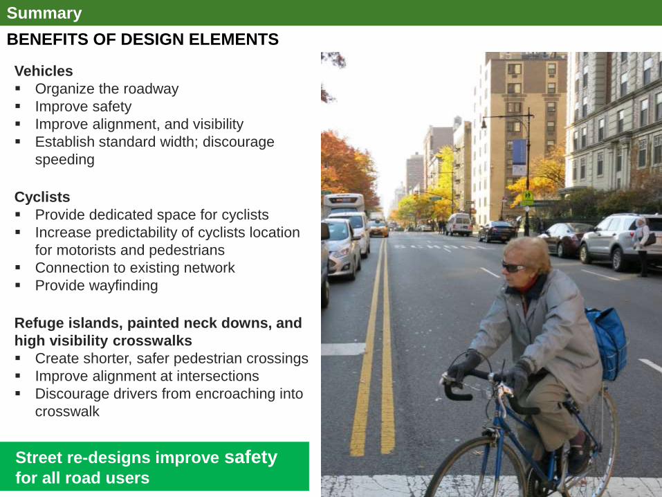
BENEFITS OF DESIGN ELEMENTS
Summary
Vehicles
Organize the roadway
Improve safety
Improve alignment, and visibility
Establish standard width; discourage
speeding
Cyclists
Provide dedicated space for cyclists
Increase predictability of cyclists location
for motorists and pedestrians
Connection to existing network
Provide wayfinding
Refuge islands, painted neck downs, and
high visibility crosswalks
Create shorter, safer pedestrian crossings
Improve alignment at intersections
Discourage drivers from encroaching into
crosswalk
Street re-designs improve safety for all road users
High-visibility crosswalks
Traffic calming e.g. road diets
Signal timing changes
Sidewalk enhancements
Curb management e.g. loading zones
Transit enhancements e.g. bus islands
Street re-designs improve safety
for all road users

4 Additional Outreach and Follow Up

Community request for street resurfacing at June CB Meeting Resurfacing on some streets including sections of 110th St and 111th St started in July DOT will continue to assess paving conditions and resurface as necessary
RESURFACING
Additional Outreach and Follow Up

SUMMARY OF ADDITIONAL OUTREACH
Additional Outreach and Follow Up
Street re-designs improve safety for all road users
High-visibility crosswalks
Traffic calming e.g. road diets
Signal timing changes
Sidewalk enhancements
Curb management e.g. loading zones
Transit enhancements e.g. bus islands
Walk Throughs with CB 10 and CB 11:
July 14, 2017:
5th Ave (120th St to 110th St)
August 30, 2017
5th Ave (120th St to 110th St)
Street Ambassador Deployments:
Talked to nearly 250 people about bicycle facilities,
proposed routes, answered general questions, and
distributed giveaways and educational materials
August 24, 2017
116th St & Park Ave – El Barrio Youth Marqueta
August 26, 2017
124th St & 5th Ave
August 27, 2017
110th St & Malcolm X Blvd
Coordination with Partner Organizations :
Every Third Saturday (Ongoing since June)
East Harlem Neighborhood Health Action Center
(NYC Department of Health & Mental Hygiene) • Attended monthly meetings and group biking and walking
tours, presented proposed projects
August 15, 2017
Cyclopedia (Youth Summer Biking and
Educational Program) • Group discussion about street design and DOT tool box

All DOT Proposals are Reviewed by FDNY • Emergency vehicle
access is maintained or improved
Department of Sanitation • New designs are reviewed by the agency • Protected bike lanes are designed to allow for garbage and snow removal
RESPONSE TO QUESTIONS RAISED AT WALK THROUGHS
Additional Outreach and Follow Up
How will this affect emergency vehicle access? How will streets be swept and plowed?

Wide Parking Lanes • Space for moving vehicles to pass vehicles dropping off/pick uping passengers and deliveries
Updated Parking Regulations/Loading Zones • DOT can investigate loading zones along the corridor to accommodate delivery vehicles
12’
Parking lane
3’
Buffer
east
sidewalk
west
sidewalk
Additional Outreach and Follow Up
RESPONSE TO QUESTIONS RAISED AT WALK THROUGHS
Will vehicles loading/unloading block traffic?

WALK THROUGH QUESTIONS:
Photo with a lot of cyclists
514
221
280
100
601
426
166
220
98
484
0
100
200
300
400
500
600
700
Crashes withInjuries
MV OccupantInjuries
PedestrianInjuries
CyclistInjuries
Total Injuries
Nu
mb
er
of
Inju
rie
s
Before After
Protected bicycle lane projects with 3 years of after data include the following: 9th Ave (16th-31st), 8th Ave (Bank-23rd, 23rd-34th), Broadway (59th-47th, 33rd-26th, 23rd-18th), 1st Avenue (Houston to 34th), 2nd Ave (Houston-34th), Columbus Ave (96th-77th) Note: Only sections of projects that included protected bicycle lanes were analyzed Source: NYPD AIS/TAMS Crash Database
Protected Bicycle Lanes with 3 years of After Data: Before and After -20%
-22%
-2%
-25%
-17%
decline in total injuries
- 20%
In general protected bike lanes improve safety for all users:
Crashes with injuries have been reduced by 17%
Pedestrian injuries are down by 22%
Cyclist injuries show a minor improvement even as bicycle volumes have dramatically increased
Additional Outreach and Follow Up
RESPONSE TO QUESTIONS RAISED AT WALK THROUGHS
How do protected bike lanes impact street safety?

STREET AMBASSADOR DEPLOYMENT SUMMARY: HARLEM BIKE NETWORK AUGUST 24, 26, 27, 2017
42
Unit Supported Bikes and Greenways
Dates August 24, 26, 27, 2017
Locations 116th St & Park Ave 124th St & 5th Ave 110th St & Malcolm X Blvd
# Interactions Approximately 250
Notable Feedback Overall the feedback was positive on both days. Residents we spoke to were excited to hear Citi Bike was coming to the area and liked the idea of the lanes connecting to green spaces. Concerns included bike lanes being placed on narrow streets and better bike education
WHAT WE HEARD ON THE STREET
Additional Outreach and Follow Up

43
Harlem Bike Network - August 24, 26, 27, 2017
Additional Outreach and Follow Up
WHAT WE HEARD ON THE STREET

Questions?
THANK YOU!
44
NYCDOT nyc_dot nyc_dot NYCDOT