Big Rock Quarry
22
73 Stop 6: Big Rock Quarry North Little Rock (Pulaski County), Arkansas STOP 5 STOP 6
-
Upload
adam-budi-nugroho -
Category
Documents
-
view
22 -
download
0
description
Big Rock Quarry
Transcript of Big Rock Quarry

73
Stop 6: Big Rock Quarry
North Little Rock (Pulaski County), Arkansas
STOP 5 STOP 6

74
Primary Objectives
Study the reservoir continuity and depositional processes of a proximal submarine-fan conduit.
Consider potential issues encountered during well-to-well correlation and identify mitigation possibilities to reduce negative impact on model building.
Introduction Big Rock Quarry is a large, inactive quarry located in North Little Rock, Arkansas, on the north bank of the Arkansas River across from the city of Little Rock (see topographic map). A proximal submarine-fan channel complex in the Jackfork Group is exposed in the north – south trending quarry which is almost 3000 ft (915 m) long and up to 200 ft (61 m) high (Fig. 1). The orientation of the quarry approximates a strike view through the channel complex. Individual lithologic units are laterally discontinuous and are mainly composed of a mixture of clean, high-density turbidite beds and chaotic, muddy to sandy mass flow deposits, including debris flow, slump and slide deposits. Geologic Setting Pennsylvanian (Morrowan) sandstones and interbedded shales on the Big Rock Quarry wall represent the lower part of the upper Jackfork Group. Shales of the lower Jackfork form the floor of the northwestern part of the quarry (Jordan et al., 1991). The deposits exposed in the quarry represent part of a much larger channel complex. Stone and McFarland (1981) report that this sequence pinches out within about 2.5 miles (4 km), but outcrops are sparse and the area may be faulted. Regional facies studies by Link and Roberts (1986) suggest that the Big Rock Quarry area was close to the northeastern limit of the deep-water Ouachita Trough during the time of deposition of the Jackfork Group (Fig. 2). However, the precise location of the coeval shelf edge for this outcrop is not known, leaving some latitude for speculation about the setting of the channel deposits. Various authors have interpreted this as an inner (upper) submarine fan valley or as a channel in a submarine canyon (Jordan et al., 1991).

75
Sediment sources for this submarine channel system were fluvial and deltaic systems coming into the basin from the Illinois Basin to the northeast. Sediments were also supplied to the basin floor from other sources, including the Southern Appalachians and the orogenic belt along the southeastern side of the basin (Fig. 2) (Link and Roberts, 1986). Outcrop and Core Characterization
The vertical wall of the Big Rock Quarry exhibits a complex network of channel deposits. There is a noticeable change in the character of the deposits, from massive sandstones in the lower and middle parts of the outcrop to interbedded sandstone and mudstone near the top (Figs. 1, 3). This change reflects a significant transformation in the depositional style from the early- to the late-stage of channel infilling processes. Outcrop. The sandstone beds are mainly massive or structureless (Figs. 3, 4), but planar or cross laminations, liquification and water escape structures are observed in some beds. Laterally, the massive lower section maintains a similar general character across the quarry, although few if any of the lenticular sandstone units extend more than a few hundred feet. From a distance, the quarry wall appears to consist mainly of the massive and featureless sandstone beds (Fig. 1). Upon closer inspection, however, the heterogeneous nature of the channel fill facies is revealed. In addition to sandy turbidites, muddy and sandy debrites, shale intraclast breccias, slurry beds, and bedded shales constitute prominent facies (Figs. 3-7). Large blocks on the quarry floor provide an opportunity to view of some the facies which are inaccessible on the quarry wall (Fig. 7). Some of the muddy debris flow and shale layers exposed on the southern side of the quarry appear to fill or drape on irregular eroded surfaces (Figs. 3, 5). While the debris flows could comprise both the erosional and depositional event, it seems more plausible that the truncated surfaces were cut by larger slumps and slides and subsequently filled by lower-energy deposits. Core. An 80-ft (24.4-m) core recovered by Shell Research in the mid-1980‟s is a good representation of the facies observed in the outcrop, and is especially meaningful as it provides details difficult to ascertain from rocks high on the quarry wall (Figs. 8, 10). Turbidite sandstone facies (massive, dewatered and laminated) make up about two-thirds of the cored interval with amalgamated, massive sandstones being dominant (Fig. 4 bottom). Individual sandstone beds range from thin- to very thick-bedded (0.17 ft, 5 cm to 3.87 ft, 1.18 m), but the bulk of the beds are medium bedded (0.3-1.0 ft (10-30 cm) thick). Shale intraclast breccias/conglomerates occur throughout the core dominating the sand-poor intervals obvious in the outcrop gamma ray log (Fig. 8). The facies is characterized by elongated, blocky clasts of shale and sand and commonly shows evidence of shearing (Fig. 7). Sediment creep or small localized failures on an unstable

76
channel margin are considered to be the most likely origin of the facies (Jordan et al., 1991, Cook et al., 1994). Although not a common deepwater facies, it has been associated with other apparently lateral migrating channel deposits in other localities (e.g., Ross Sandstone in Ireland, Solitary Channel in southern Spain). Chaotic to contorted muddy and sandy debrites and mudstones comprise only 10% of the core facies. Many of the dark, debrite facies identified in the quarry walls are likely shale intraclast breccias instead (see Fig. 3). Hierarchical Stratigraphy The complex architecture of a deep-water channel situated near the base-of-slope is well exposed in the Big Rock Quarry. The complexity visible on the east quarry wall offers a good analog for many of the discoveries and producing fields in West Africa. Hierarchically, the channel system comprises a complex set which can be subdivided into two depositional complexes (Figs. 10-12). The lower depositional complex is a high net to gross amalgamated channel complex characterized by nine lenticular channel elements which typically are about 1200-ft (370-m) long and 50-ft (15-m) thick. The low aspect ratio (1:24 average) of the channel elements is a product of the elements being aligned in the paleo-flow direction rather than perpendicular to the flow. Internally, the channel exhibit both lateral accretion and vertical aggradation, but the channel orientation, relatively flat attitude of the beds, uniform nature of the amalgamated sandstone beds and truncation by younger channels make these features difficult to see in the short time allowed on a field trip. The upper depositional complex is a low net to gross semi-amalgamated channel complex consisting of at least 15 channel elements characterized by shifting, lateral migration channels. The base of the complex is dominated by entrenched, stacked channel elements (confined areally between ARCO logs #1 and #2), but rapidly changes to the lateral migrating channel elements visible in the upper part of the quarry. Individual channels tend to be about 1000-ft (300-m) long and 40-ft (13-m) thick. Length to width ratio is similar to the lower depositional complex. These channels are interbedded with mudstones and shale intraclast breccias of channel margin and extra-channel (i.e., overbank) environments. Recognition of a complex channel fill and it‟s hierarchical components is critical early on in a subsurface project. Input parameters and variograms will be markedly different between the depositional complexes and impact both original oil-in-place and recoverable oil calculations. Reservoir Implications Although the lower and middle of the channel complex in the quarry wall is over 90% sandstone, the thin shaly layers might represent significant barriers to vertical and lateral connectivity in an equivalent subsurface reservoir. Most of the shaly intervals, however, are not low-energy mud drape, but instead are muddy debris flows that have eroded into the underlying sandstone layers. These muddy debris flows are as

77
impermeable as low-energy hemipelagic shales, but not as laterally continuous. The implications of these 3-dimensional connections may be very different depending on whether similar geometries are found in gas vs. oil-filled reservoirs.

78

79
Figure 2. Schematic Morrowan paleogeographic reconstruction showing the primary depositional systems in Arkansas (with permission from M. T. Roberts).

80
Figure 3. Photograph of wall in southern side of quarry (near Log #1) showing the complex bedding relationships between turbidite sandstone, muddy and sandy debrites, shale intraclast breccias and laminated shale facies. Bedding planes are clearly evident in some of the sandstone turbidite beds, especially in the right-center of the photograph. The amalgamated contacts suggest only minor erosion during deposition. The debrites, however, exhibit a more erosive depositional character overlying undulatory and deep-cut bedding contacts (red arrows). Debrites are also common as a draping facies at the base of channel elements (white arrow). See Figures 4 to 7 for detailed views of some of the other facies in the Big Rock Quarry.

81
Figure 4. Turbidite sandstone facies from the Big Rock quarry wall. The upper photo shows alternating sandstone turbidites (at hammer) and thin dark shaly beds, some of which are muddy debris flow deposits and slurry beds. The lower photo shows a thick (> 6 ft (2 m)) sandstone bed with a central zone of mudclasts, representing deposition from a single high-density turbidity flow.

82
Figure 5. Interbedded medium- to thick-bedded sandstone and muddy shale intraclast breccias. Note erosive contact of breccias and conformable contact of sandstones.
Figure 6. Bedded to interlaminated, dark mudstone overlying a erosive-based muddy debrite. Mudstones are more common in the southern end of the quarry as they are better preserved in the upper depositional complex which is exposed lower down on the quarry wall.
83
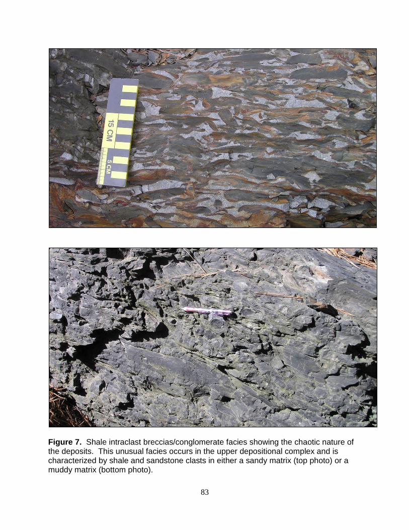
Figure 7. Shale intraclast breccias/conglomerate facies showing the chaotic nature of the deposits. This unusual facies occurs in the upper depositional complex and is characterized by shale and sandstone clasts in either a sandy matrix (top photo) or a muddy matrix (bottom photo).

84
Figure 8. Core description and hierarchical stratigraphy of Shell core, Big Rock Quarry, Arkansas. See Figure 9 for key to lithological symbols.

85
Figure 9. Symbols key to core lithologies and outcrop facies observed in Big Rock Quarry, Arkansas.

86
Figure 10. Outcrop facies, Shell core lithologies and hierarchical stratigraphy at ARCO Log #1, Big Rock Quarry, Arkansas. See Figure 9 for key to lithological symbols.

87
Figure 11. Outcrop facies and hierarchical stratigraphy at ARCO Log #2, Big Rock Quarry, Arkansas. See Figure 9 for key to lithological symbols.

88
Figure 12. Outcrop facies and hierarchical stratigraphy at ARCO Log #3, Big Rock Quarry, Arkansas. See Figure 9 for key to lithological symbols.

89
References Al-Siyabi, H. A., 2000, Anatomy of a type II turbidite depositional system: Upper
Jackfork Group, DeGray Lake area, Arkansas, in A. H. Bouma and C. G. Stone, eds., Fine-grained turbidite systems. AAPG Memoir 72/SEPM Special Publication No. 68, p. 245-262.
Arbenz, J. K., 1989, The Ouachita system, in Bally, W. A., and Palmer, A. R., eds., The
Geology of North America - an Overview, The Geology Society of America, The Geology of North America, Vol. A, Chapter 14, p. 372-396.
Beaubouef, R. T., C. Rossen, M. D. Sullivan, D. C. Mohrig, and D. C. Jennette, 1999,
Deep-water sandstones, Brushy Canyon Formation, West Texas: Field guide for AAPG Hedberg field research conference, April 15-20, 42 p.
Bouma, A. H., 1962, Sedimentology of some flysch deposits: Amsterdam, Elsevier Sci.
Pub., 168 p. Bouma, A. H., and E. D. Scott, 2003, Source-to-Sink: The Importance of the Updip
Coastal Area in Defining Deep-Water Sand Characteristics, CD-ROM, 23rd Annual GCSSEPM Foundation Conference, Houston, TX, p. 597
Breckon, C. E., 1988, Sedimentology and facies of the Pennsylvanian Jackfork Group in
the Caddo Valley and DeGray quadrangles, Clark County, Arkansas: Ph. D. dissertation, The University of Tulsa, 134 p.
Coleman, J. M., and Gagliano, S. M., 1964, Cyclic sedimentation in the Mississippi
River deltaic plain: Gulf Coast Association Geological Societies, v. 14, p. 67-80. Cook, T. W., 1993, Facies architecture of deepwater channel deposits, Brushy Canyon
Formation, West Texas, and Jackfork Group, Arkansas. Unpublished M.S. thesis, Louisiana State University, 108 pp.
Cook, T. W., Bouma, A. H., Chapin, M. A., and Zhu, H., 1994, Facies architecture and
reservoir characterization of a submarine fan channel complex, Jackfork Formation, Arkansas: in Submarine fans and turbidite systems, GCSSEPM Foundation 15th Annual Research Conference, Houston, TX, December 4-7, p. 69-81.
Galloway, W. E., and D. K. Hobday, 1983, Terrigenous clastic depositional systems:
applications to petroleum, coal, and uranium exploration, Chapter 4, Fluvial systems: Springer-Verlag (New York), p. 51-79.
Gangopadhyay, T., 1997, High resolution facies analysis of deltaic subenvironments of
the Pennsylvanian Atoka Formation, Arkansas: Unpublished Ph.D. dissertation, Louisiana State University, 212 p.

90
Haley, B. R., 1961, Thickness trends in the Hartshorne Sandstone and the McAlester Formation in northwest Arkansas: U.S. Geological Survey Prof. Paper 424-C, Art. 180, p. C80-C81.
Harms, J. C., J. B. Southard, D. R. Spearing, and R. G. Walker, 1975, Depositional
environments as interpreted from primary sedimentary structures and stratification sequences, Chapter 3, Stratification produced by migrating bed forms: SEPM Short Course No. 2 (Dallas), p. 45-61.
Haughton, P. D. W., S. P. Barker, and W. D. McCaffrey, 2003, „Linked‟ debrites in sand-
rich turbidite systems – origin and significance: Sedimentology, v. 50, p. 459-482. Hickson, T. A., 1999, A study of deep-water deposition: constraints on the
sedimentation mechanics of slurry flows and high concentration turbidity currents, and the facies architecture of a conglomeratic channel-overbank system: PhD dissertation, Stanford University, April 1999.
Houseknecht, D. W., ed., 1983, Tectonic-sedimentary evolution of the Arkoma Basin:
Soc. Econ. Paleontologists and Mineralogists Mid-continent Section Guidebook, vol. 1, 119 p.
Houseknecht, D. W., and J. A. Kacena, 1983, Tectonic and sedimentary evolution of the
Arkoma foreland basin, in D. W. Houseknecht, ed., Tectonic-sedimentary evolution of the Arkoma Basin: Soc. Econ. Paleontologists and Mineralogists Mid-continent Section Guidebook, vol. 1, p. 3-33.
Jordan, D. W., Lowe, D. R., Slatt, R. M., Stone, C. G., D'Agostino, A., Schelhing, M. H.,
and Gillespie, R. H., 1991, Scales of geological heterogeneity of Pennsylvanian Jackfork Group Ouachita Mountains, Arkansas: applications to field development and exploration for deep-water sandstones, American Association of Petroleum Geologists Annual Convention: Dallas, TX, Dallas Geological Society, p. 142+.
Jordan, D. W., Slatt, R. M., Gillespie, R. H., Agostino, A. D., and Stone, C. G., 1993,
Gamma ray logging of outcrops by a truck-mounted sonde: American Association of Petroleum Geologists Bulletin, v. 77, p. 118-123.
Kear, G. R., C. E. Stelting, S. E. Turner, and C. G. Stone, 1997, Borehole electrical
images and dipmeter patterns of fluvial-deltaic reservoirs: outcrop examples from Arkansas (abs.): Gulf Coast Association Geological Societies, v. 41, p. 654-655.
Klein, G. D., 1992, Subaqueous gravity processes on the front of Cretaceous deltas,
Reconcavo Basin, Brazil: GSA Bulletin, v. 83, p. 1469-1492. Link, M. H., and M. T. Roberts, 1986, Pennsylvanian paleogeography for the Ozarks,
Arkoma, and Ouachita basins in east-central Arkansas, in Stone, C. G., and B. R.

91
Haley, eds., Sedimentary and Igneous Rocks of the Ouachita Mountains of Arkansas: Arkansas Geological Commission, Guidebook, part 2, p. 37-60.
Lowe, D. R., 1982, Sediment gravity flows: II. Depositional models with special
reference to the deposits of high-density turbidity currents: Jour. Sed. Petrol., v. 52, p. 279-297.
Mayall, M. J., C. A. Yielding, J. D. Oldroyd, A. J. Pulham, and S. Sakurai, 1992, Facies
in a shelf-edge delta -- an example from the subsurface of the Gulf of Mexico, Middle Pliocene, Mississippi Canyon, Block 109: AAPG Bulletin, v. 76, no. 4, p. 435-448.
McFarland, J. D., III, 1988, Turbidite exposures near DeGray Lake, south-western
Arkansas: Geological Society of America Centennial Field Guide, South-Central Section, p. 273-275.
McGilvery, T. A. and Houseknecht, D. W., 2000, Depositional systems and diagenesis
of slope and basin facies, Atoka Formation, Arkoma basin, in Johnson, K. S. (ed), Marine clastics in the southern Midcontinent, 1977 symposium: Oklahoma Geological Survey Circular 103, P. 129-140
Morris, R. C., 1971, Stratigraphy and sedimentology of the Jackfork Group, Arkansas:
Amer. Petrol. Geol. Bull., v. 55, p. 387-402 Morris, R. C., 1974, Geological Society of America Special Paper No 148, Briggs Ed Morris, R. C., 1977, Flysch facies of the Ouachita Trough – with examples from the
spillway at DeGray Dam, Arkansas, in C. G. Sloan, ed., Symposium on the Geology of the Ouachita Mountains: Arkansas Geol. Commission, v. 1, p. 158-169.
Pickering, K. T., and V. C. Hilton, 1977, Turbidite systems of southeast France: Vallis
Press, London, 229 p. Roberts, M. T., 1984, Oxy Cities Service Corporation Guidebook #110. Presented to
Arkansas Geologic Commission (C.G. Stone), April 1984. Ross, Charles A. and June R. P. Ross, 1998, Late Paleozoic Transgressive-Regressive
Deposition, Sea-Level Changes: An Integrated Approach, SEPM Special Publication No. 42, Tulsa, OK Fig. 9, p. 243
Shanmugam, G., and R. G. Moiola, 1995, Reinterpretation of the depositional
processes in the classic flysch sequence (Pennsylvanian Jackfork Group), Ouachita Mountains, Arkansas and Oklahoma: AAPG Bulletin, v. 79, p. 672-695.

92
Slatt, R. M. and Stone, Charles G., 1998, Geology of the Deep-Water Pennsylvanian Jackfork Group, Little Rock - Hot Springs Area, Arkansas, AAPG Field Trip November 7-8, 1998 Field Trip Guidebook.
Slatt, R. M., C. G. Stone, and P. Weimer, 2000, Characterization of slope and basin
facies tracts, Jackfork Group, Arkansas, with applications to deepwater (turbidite) reservoir management: GCSSEPM Foundation 20th Research Conference, Deep-Water Reservoirs of the World, pp. 940-980.
Stelting, C. E., and W. J. Schweller, 1997, Delta-front turbidites: a poorly understood
but productive play type in the Gulf Coast: Transactions of the Gulf Coast Association of Geological Societies, v. 47, p. 659.
Stelting, C. E., G. R. Kear, and C. G. Stone, 1999, Outcrop analogs for Gulf Coast
fluvial, deltaic, and turbidite reservoir sandstones: New Orleans Geol. Soc.-New Orleans Soc. of Prof. Well Log Analysts field trip guidebook (Nov. 12-14), 40 p.
Stelting, C. E., G. R. Kear, Bouma, A. H., and C. G. Stone, 2004, Fluvial-Deltaic-
Submarine Fan Systems: Architecture and Reservoir Characteristics: Jackfork, Atoka, and Hartshorne Formations, Arkansas: AAPG-SPEM Guidebook Field Trip #8 AAPG 2004 Annual Conference (Apr. 12-24, 2004).
Stelting, C. E., W. J. Schweller, G. Ellis, S. E. Turner, M. E. Cribbs, and F. Yip, 2007,
Reservoir characterization of confined sheet reservoirs using borehole images and core, Tahiti Field, Gulf of Mexico, U.S.A.
Stone, C. G., and McFarland, J. D., III, 1981, Field guide to the Paleozoic rocks of the
Ouachita Mountains and Arkansas valley provinces, Arkansas: Arkansas Geological Commission Guidebook 81-1, 140 p.
Sutherland, Patrick K. and Manger, Walter L., 1979, Mississippian-Pennsylvanian Shelf-
To-Basin Transition Ozark and Ouachita Regions, Oklahoma and Arkansas, Oklahoma Geology Survey Guidebook 19, ISSN 0078-4400, Guidebook Ninth International Congress of Carboniferous Stratigraphy and Geology, The University of Oklahoma, Norman, OK
Viele, G. W., and Thomas, W. A., 1989, Tectonic synthesis of the Ouachita orogenic
belt, in Hatcher, R. D., Jr., Thomas, W. A., and Viele, G. W., eds., The Appalachian-Ouachita Orogen in the United States: Boulder, Colorado, Geological Society of America, The Geology of North America, v. F-2
Welder, F. A., 1955. Deltaic processes in Cubits Gap area Plaquemines Parish,
Louisiana: Unpublished Ph.D. dissertation, Louisiana State University, 119 p.

93
Wright, C. M., 2002, Significance of variations among ancient deltaic deposits in the Arkansas Basin, north-central Arkansas: Unpublished M. S. thesis, Louisiana State University, 161 p.

94
FIELD TRIP STOPS LOCATION MAP:
Stops 1 – 2 Slope Channels (Jackfork Group)
Stops 3 – 5 Basin Floor Channels and Sheets (Jackfork Group)
Stop 6 Basin Floor Distal Sheets (Stanley Shale)
1
2
3
4
5
6