Best Practices Guide - Reduction of Greenhouse Gas Emissions and Land User Planning
77
Reduction of Greenhouse Gas Emissions and Land Use Planning B e st Practices G uid e
Transcript of Best Practices Guide - Reduction of Greenhouse Gas Emissions and Land User Planning

Reduction of Greenhouse Gas Emissions andLand Use Planning
Best Practices Guide

Reduction of Greenhouse Gas Emissions and Land Use Planning 2
This publication was produced by the ministère des Affaires municipales et des Régions (MAMR).
This text was translated from french.
The following branches collaborated in the development of the guide:
Ministère des Affaires municipales et des Régions
> Direction de la planification et de la recherche
> Direction de l’aménagement et du développement local
> Direction des infrastructures
> Direction des politiques municipales et urbaines
Ministère du Développement durable, de l’Environnement et des Parcs
> Bureau des changements climatiques
The MAMR also wishes to acknowledge the collaboration of Vivre en Ville for adding this new
title, in the form of a CD-ROM, to its Trousse d’actions - Vers des collectivités viables.
Research
Mathieu Langlois, with the collaboration of Karine Bonneville, Direction de la planification et
de la recherche
Editing
Pierre Blais, urban planner, with the collaboration of Mathieu Langlois, Direction de la
planification et de la recherche
Acknowledgements
We would like to thank, in particular, the resource persons from the municipalities consulted for
the descriptions of best practices presented in this guide.
Production
Service de l’information et de l’édition, Direction des communications
Graphic design
Corsaire design
Cover photo: Québec, Claude Chabot
This publication is also available on the department’s Web site (www.mamr.gouv.qc.ca).
Legal deposit
National Library of Canada
Bibliothèque nationale du Québec
ISBN 2-550-45817-6
© Gouvernement du Québec, 2005

Reduction of Greenhouse Gas Emissions and Land Use Planning3
TABLE OF CONTENTS
INTRODUCTION 5
1 REDUCTION OF GREENHOUSE GAS EMISSIONS AND LAND USE PLANNING 7
1.1 Greenhouse gases 71.2 Emission sources 91.3 Land use planning challenges related to urbanization models 11
2 STRATEGIES TO REDUCE GREENHOUSE GAS EMISSIONS 13
2.1 Urbanization Management 13
2.1.1 Consolidate and structure urbanization for the agglomeration 17
Strategies 17
Means of action 19
CASE STUDIES
Longueuil: Consolidation of urbanization through the development of the area along boulevard Taschereau 21
Drummondville: Planning and development of commercial spaces 24
2.1.2 Consolidate and revitalize city centres and central neighbourhoods 26
Strategy 26
Means of action 28
CASE STUDIES
Québec: Revival of the Saint-Roch area, the Lower Town business centre 30
Montréal: The Angus project and the redevelopment of a run-down industrial site 32
Gatineau: Residential revival on the Île de Hull 35
Trois-Rivières: Revitalization of Vieux-Trois-Rivières and surrounding downtown neighbourhoods 38
2.1.3 Increase density and diversify use in urbanized peripheral zones 39
Strategy 39
Means of action 42
CASE STUDIES
Québec: Comprehensive plan for the Faubourg Laudance area and its centre, rue du Campanile 43
Gatineau: The development of a multipurpose regional centre 46

Reduction of Greenhouse Gas Emissions and Land Use Planning 4
2.2 The development of transportation infrastructure 49
2.2.1 Design an integrated transportation infrastructure network in accordance with urbanization management strategies 49
Strategy 49
Means of action 54
CASE STUDIES
Châteauguay: Planning a bikeway network for the entire city 55
Baie-Comeau: A strategic cycle path to better integrate urbanized areas 56
Québec: The utilitarian nature of the bicycle path on chemin des Quatre-Bourgeois 56
2.3 Urban forests 57
2.3.1 Reforest open space and protect green spaces 57
Strategy 57
Means of action 60
CASE STUDIES
Québec: A master plan for the natural environment and urban forests 62
Montréal: Green space protection on Île-des-Soeurs 64
Victoriaville: A well established urban forestry policy 66
Other noteworthy practices 67
BIBLIOGRAPHY 69
GLOSSARY OF TERMS USED IN THE ACT RESPECTING LAND USE PLANNING
AND DEVELOPMENT 70
GLOSSARY OF TERMS PERTAINING TO GREENHOUSE GASES 76

Reduction of Greenhouse Gas Emissions and Land Use Planning5
The international scientific community recognizes that the increase in greenhouse gases(GHG) is one of the leading causes of climate change, and that its consequences willbe increasingly felt in the coming decades.
In Québec, greenhouse gas emissions stemming from human activity reached anestimated 81.9 million tonnes of CO2 equivalent in 1991 and 83.4 million tonnes in1996.
If nothing is done to check such emissions, they will reach 94.1 million tonnes in 2011and 105.1 million tonnes in 2026.1 It is against this backdrop, in keeping with theUnited Nations Framework Convention on Climate Change and in conjunction withtalks stemming from the ratification of the Kyoto Protocol, that Québec has adopted anaction plan to reduce greenhouse gas emissions.
This guide stems from the Québec Action Plan on Climate Change2 and is intended forland use planning and development policies to take into account the objective ofreducing greenhouse gas emissions.
It is in this perspective that the guide is aimed, first and foremost, at stakeholders in themunicipal sector, whether they are elected representatives, professionals, members ofurban planning or land use planning committees, or residents. It is also intended forindividuals in government departments or other public or private organizations whosesphere of action can significantly impact land use development and transportation.
1 Gouvernement du Québec, Comité interministériel sur les changements climatiques, Problématique des transports et deschangements climatiques au Québec — Rapport du groupe de travail sur les transports, November 1999, page 7.
2 Gouvernement du Québec, Québec Action Plan on Climate Change 2000-2002 [online], 2000, 42 pages(http:www.mddep.gouv.qc.ca/changements/plan-action.pdf
This guide stems from the Québec Action Plan
on Climate Change
INTRODUCTIONLand use planning strategies can help reduce greenhouse gas emissions.

Reduction of Greenhouse Gas Emissions and Land Use Planning 6
The guide is intended specifically to:
> review the issues related to climate change and the need to reduce greenhouse gasemissions;
> promote, in keeping with the government’s land use planning orientations, strategiesthat help to reduce greenhouse gas emissions;
> show how planning, regulatory and other tools provided by the Act respecting landuse planning and development can be used to implement such strategies;
> present case studies of Québec municipalities where land use planning strategyinitiatives contribute to the reduction of greenhouse gas emissions.
In particular, it focuses on urbanization models that are likely to reduce pollutantsproduced by the transportation sector, the leading source of greenhouse gas emissionsof human origin in Québec. In this perspective, it emphasizes urbanizationmanagement strategies that can have an impact on the choice of transportation mode,the distances travelled and the number of automobile trips in urban areas.
The guide also defines complementary development strategies pertaining totransportation infrastructure, urban forests and green spaces.

Reduction of Greenhouse Gas Emissions and Land Use Planning7
1.1 Greenhouse gasesThe greenhouse effect is a natural phenomenon whereby the Earth’s heat is trapped inthe atmosphere by certain gases. Greenhouse gases thus contribute to maintaining asurface temperature on Earth favourable to life.
Industrialization and the population explosion that have occurred over the past 200years have been accompanied by a substantial increase in the use of fossil fuels such ascoal, oil and natural gas, thus leading to an equally considerable increase in greenhousegas emissions in the atmosphere. The additional greenhouse gas emissions have in turnexacerbated the greenhouse effect, which appears to be the cause of the increase in thetemperature of the Earth’s surface and the lower layers of its atmosphere.
Since 1860, according to the World Meteorological Organization, nine of the 10 hottestyears on a global scale occurred after 1990. Climatic warming is likely to increaseduring the winter and in northern regions. In Québec, by 2050 or even earlier, climaticchange could lead to an temperature increase between 1°C and 6°C, in the south, andbetween 2°C and 9°C, in the north, depending on the seasons.3
1 Reduction of Greenhouse Gas Emissions and Land Use Planning
Greenhouse gas emissions can be reduced through a form of urbanization that makes it possible to reduce automobile trips.
3 Gouvernement du Québec, Québec Action Plan on Climate Change 2000-2002 [online], 2000, page 16(http:www.mddep.gouv.qc.ca/changements/plan_action.pdf)

Reduction of Greenhouse Gas Emissions and Land Use Planning 8
CO2 and other greenhouse gases
To mitigate the impact of anticipated climate change (see box on page 10), theinternational community has adopted the objective of reducing emissions of sixgreenhouse gases (see page 76):
> carbon dioxide (CO2);
> methane (CH4);
> nitrous oxide (N2O);
> hydrofluorocarbons, sulphur hexafluoride and perfluorocarbons.
Among the six greenhouse gases mentioned, carbon dioxide is the leading greenhousegas stemming from human activities. For this reason, the volume of greenhouse gases inthe air is often expressed as tonnes of CO2 equivalent, which serves as a reference unitfor other gases.
The carbon cycle, which represents exchanges of carbon between terrestrial andoceanic ecosystems, on the one hand, and the atmosphere, on the other, is now largelyaffected by disturbances of human origin.
Automobiles are theleading source ofgreenhouse gases
in Québec.
Phot
o:
Mat
hieu
Lan
gloi
sPh
oto
: Pi
erre
Lah
oud
Industry is the secondsource of greenhouse
gases in Québec.
Phot
o:
Pier
re L
ahou
d

Reduction of Greenhouse Gas Emissions and Land Use Planning9
1.2 Emission sources
Figure 1 presents the breakdown of greenhouse gas emissions of human origin in 1990and in 2001, in Québec. It also highlights the importance of the proportion ofgreenhouse gas emissions stemming from transportation, which rose between 1990 and2001, while emissions engendered by industry and electricity declined. Emissions fromeach of the other sectors remained essentially stable.
The ministère des Ressources naturelles forecasts that, for the period 1996-2011, thetransportation sector will also account for most of the growth in greenhouse gasemissions.4 It should be noted that, in addition to greenhouse gas emissions, thetransportation sector also contributes to other forms of air pollution such as smog andacid rain.
Agriculture
WasteOther
Electricity
Industry
Residential,commercial andinstitutional
Transportation
6.9%
9.5%
33.9%
Transportation38.9%
0.3%Other0.3%
1.7%Electricity0.4%
34.7%Industry31.0%
12.9%
Residential,commercial andinstitutional13.1%
Waste6.1%
Agriculture10.1%
CHART 1
Greenhouse gasemissions
by source in Québecin 1990 and 2001
4 Gouvernement du Québec, ministère des Ressources naturelles, Évolution de la demande d’énergie et des émissions de gazà effet de serre au Québec : scénario de référence 1996-2021. Québec, 2001, pages 28-29.
5 Gouvernement du Québec, Comité interministériel sur les changements climatiques, Problématique des transports et deschangements climatiques au Québec – Rapport du groupe de travail sur les transports, November 1999, page 68.
Source: Ministère de l’Environnement du Québec,October, 2003.
The automobile, principal source of greenhouse gases
The transportation sector and, in particular, automobile trips, are likely to be targeted inorder to attain greenhouse gas emission reduction objectives.
In 1996, automobiles and light trucks accounted for 76% of overall passenger-kilometres. This proportion rises to nearly 90% when certain means of transportationsuch as airplanes and trains are excluded.5 Nearly 84% of these trips occurred in urbanareas while 16% were intercity trips.
Even though the Montréal and Québec agglomerations contribute significantly to theincrease in greenhouse gas emissions because of the size of their population and thenumber of trips that take place there, it is nonetheless important to consider thatmedium-sized cities and smaller urban centres are also concerned by this.

Reduction of Greenhouse Gas Emissions and Land Use Planning 10
The impact of climate changeon human activitiesAnticipated climate change will perma-nently affect the environment and humanactivity. Some examples:
Infrastructure and buildings
Sewers may overflow more frequently inthe wake of heavier precipitation.Moreover, roads are likely to be subject tomore frequent freezing and thawingcycles. In some places, the erosion ofriver banks may worsen, thus threateninginfrastructure and buildings built alongthese.
New design or location criteria governingsuch infrastructure and buildings willhave to be considered, as the need arises.
Water resources
Water resources are likely to be significantlyaffected. A reduction of the St. LawrenceRiver flow is feared. Furthermore, thenormal flow of certain of its tributariescould be altered by an increase in springflooding and a reduction in summerflows.
These changes could affect water supplyfacilities and thus impact, domestic,industrial and agricultural uses.
Human health
Individuals who already suffer fromallergies or cardiovascular and respiratorydiseases may see their health deterioratebecause of climatic warming. Somepopulation groups, such as the elderly,sick individuals and children, could beespecially vulnerable to higher tempera-tures.
Perspective for land useplanning actionsLand use planning is one of the meansthat can be used to face these challengesat the national, regional and local levels.Actions may be developed with twodifferent perspectives:
> Actions to reduce greenhouse gasemissions through sustainable manage-ment of urbanization by acting directlyor indirectly on the principal sources ofhuman origin: this guide focuses onthis type of action;
> Actions to adapt to climate changefocusing on prevention of and protec-tion from natural hazards (flood plainsor erosion zones), protection of banksand shores, local infrastructure plan-ning, and so on.

Reduction of Greenhouse Gas Emissions and Land Use Planning11
1.3 Land use planning challenges related tourbanization models
Urban sprawl
Over the past 50 years, urban sprawl in the immediate vicinity of urban agglomerationshas increased ever more. Moreover, urban development has occurred in anunstructured manner in rural areas. It has also appeared in existing cities and townslocated near or within several dozen kilometres of urban agglomerations.
The resulting urban areas:
> are characterized by low-density;
> have increased distances between residential areas and workplaces, businesses andservices;
> are hardly suited to modes of transportation other than the automobile;
> have relatively less attractive central areas: many have vacant lots and underused orabandoned buildings.
Increase in automobile trips
This type of urban development generates motor vehicle trips that lead to substantialgreenhouse gas emissions and, more specifically, carbon dioxide (CO2) emissions.Indeed, the automobile is the preferred if not the only possible choice for transportation,to the detriment of mass transit, cycling or walking.
Moreover, in urban areas, an increase in the use of the automobile is accompanied byan increase in the number of vehicle trips and in the distances traveled.
Improving accessibility between places of residence, work, consumption and othertypes of activities, is important, since it will lead to fewer, less polluting trips. Actionsmust focus on:
> the number of trips;
> the distances traveled;
> the means of travel.
Table 1 illustrates the variability in greenhouse gas emissions depending on thetransportation mode and distance traveled.

Reduction of Greenhouse Gas Emissions and Land Use Planning 12
Automobile Commuter City Metro Walking (10 L/100 km) train bus or cycling
1 person 2 people 3 people 110 people 40 people 120 people
5 km 1.2 kg 0.6 kg 0.4 kg 0.2 kg 0.2 kg 0 kg 0 kg
10 km 2.4 kg 1.2 kg 0.8 kg 0.4 kg 0.3 kg 0 kg 0 kg
20 km 4.7 kg 2.4 kg 1.6 kg 0.8 kg 0.7 kg 0 kg 0 kg
50 km 11.8 kg 5.9 kg 4.0 kg 2.1 kg 1.7 kg 0 kg 0 kg
TABLE 1
CO2 emissions (kg)per person,
depending on thetransportation mode
and distance traveled
Source: Gouvernement du Québec, Agence de l’efficacité énergétique. Je lève le pied, je réduis les gaz, 2001.
Fewer, less polluting trips
In 1996, suburbanites in Québec and Montréal consumed twice as much energy forautomobile trips as their central zone residents did.6 This energy consumption patternis also found in medium-sized cities and the smaller urban centres in Québec, whereneeds for motor vehicle transportation tend to increase from the central area to theperipheral areas.
Land use planning measures that make it possible to reduce greenhouse gas emissionsshould seek to develop urban centres that broaden the opportunities for a greaternumber of people to make shorter, less frequent, less polluting trips.
Technological innovation and the design of new, less polluting vehicles are alsonoteworthy ways of reducing greenhouse gas emissions. However, technologicalinnovation does not help in reducing traffic congestion or in alleviating other problemsstemming from urban sprawl. To reduce greenhouse gas emissions, it is preferable toinclude both land use planning and technological innovation measures, rather than relysolely on the latter.
6 Id., page 70.
Distance

Reduction of Greenhouse Gas Emissions and Land Use Planning13
2 Strategies to Reduce Greenhouse Gas Emissions
Diversification of urban space is at the core of the proposed urbanization model.
Urbanization management is the main focus for the actions considered here. Two otherrelated fields are also considered, i.e. development of transportation infrastructure,urban forests and green spaces.
For each action field, the guide defines strategies and specifies different types of meansthat may be relevant. The means considered include: urban planning, regulations,development funding, land assembly, and direct action such as urban redevelopmentprojects, green space development.
Hyperlinks allow readers to access a glossary providing information on the terms usedin the Act respecting land use planning and development. This information is availableonline in a document titled La prise de décision en urbanisme7 on the Web site of theministère des Affaires municipales et des Régions.
2.1 Urbanization ManagementThe reduction of greenhouse gas emissions is a relatively recent concern, and is anaddition to a series of issues that, for 20-odd years, have made the case for bettermanagement of urbanization.
These issues include: consolidation of urban areas, reduction of development costs andof infrastructure network operating costs, especially those related to passengertransportation, air pollution control, and the protection of natural areas and farmland.
Sustainable communities
Taking into account all of these issues should lead us to adopt an urbanization modelmore in keeping with the principles of sustainable development and what are nowcalled sustainable communities. The following table presents the differentcharacteristics of this urbanization model.
7 Gouvernement du Québec, ministère des Affaires municipales, du Sport et du Loisir (2004). La prise de décision enurbanisme (3rd edition) (http://www.mamr.gouv.qc.ca/amenagement/outils/amen_outi.htm)

A residential complexin an environment
automobile dominatedarea.
Reduction of Greenhouse Gas Emissions and Land Use Planning 14
Urban sprawl model Urban sustainable development model
Density Low building density Higher overall building density, which satisfies public’sneeds just as well
Location of urban Mainly in new buildings on the Largely in renovated buildings ordevelopment periphery of built areas in new buildings within urbanized areas
Mixed nature of use Homogenous and segregated urban Urban functions are more diversified andresidential, commercial, institutional areas more extensively integrated
Transportation Urban land use planning is geared to the Urban land use planning is more concentratedautomobile and is hardly conducive to walking, and supports an array of means of motorcycling and public transportation and non-motor transportation
Public and private areas Emphasis is placed on the private domain, shopping The focus is on the public domain and meeting places,takes place in malls and most recreational activities shopping takes place along shopping streets,take place in private backyards and most recreational activities occur in public parks
Planning process There is little planning and coordination between local, An array of stakeholders is involved in strategicregional and government stakeholders planning, which is better coordinated.
TABLE 2
A sustainable developmenturbanization model
Adaptation of the table in Todd Litman, Evaluating Transportation Land Use Impacts [online]. Victoria: Victoria TransportPolicy Institute, October, 2003, page 4.
Redevelopment of thesite in compliance with
a sustainableurbanization model
Phot
os:
Urb
an A
dvan
tage

Reduction of Greenhouse Gas Emissions and Land Use Planning15
This urbanization model linked to sustainable communities should not be embraceddogmatically. It must be regarded as the most pragmatic response possible both to theneeds of individuals and the challenges facing communities. Thus, the proposedapproach seeks:
To diversify suburbs and plan their development to improve access between residencesand economic and service centres and areas through means of transportation other thanthe automobile: it is not the intent to curb the suburbs’ development at all costs;
To encourage a mix of development forms including high, medium and low density ;the intent is not to favour exclusively high-density residential areas nor to deny thedemand for single-family housing;
To better integrate all urbanization economic and environmental costs while ensuringfairness: it is not the intent to increase the costs of purchasing a property.8
Key areas for action
To better guide urban development, the urbanization management strategies proposedhere are grouped into three complementary areas for action:
1. Concentrate and structure urbanization for the entire agglomeration.
2. Consolidate and revitalize city centres and central neighbourhoods.
3. Increase density and diversify use in peripheral zones.
These strategies reflect a more comprehensive sustainable development approach.
Thus, from an economic standpoint, it is important to curb the costs related to urbansprawl that governments fund. From a social standpoint, low population growthcompels us to consolidate or revitalize existing urban areas. From an environmentalstandpoint, measures adopted to better manage urbanization and reduce greenhousegas emissions are also likely to solve other related problems, such as air pollution,destruction of natural environments, or the loss of biodiversity.
8 Based on Smart Growth BC, The Smart Growth Toolkit: helping to create more livable communities in British Columbia.Vancouver, 2001, pages I-5 and I-6.

Reduction of Greenhouse Gas Emissions and Land Use Planning 16
Proposed strategies and government land useplanning orientationsStrategies that concern urbanizationmanagement and contribute to a reduc-tion in greenhouse gas emissions are partof the government land use planningorientations. Specifically, these orien-tations* focus on:
> consolidating existing urban areas andrevitalizing city centres and older areasas a priority;
> channelling urban development inareas that can accommodate devel-opment economically and in an environ-mentally-friendly manner;
> planning industrial and commercialspaces so they may benefit from publicand private investments;
> harmonizing land use planning andenvironmental protection objectiveswith objectives set out for infrastructureplanning and public facilities,especially transportation planning.
These strategies are also in keeping withgovernment orientations that apply to theCommunauté métropolitaine de Montréal**and the Communauté métropolitaine deQuébec.*** It should be noted that thegovernment’s policy directions, madepublic in June 2001 and in December2002, respectively, explicitly address thequestion of greenhouse gas emissions andestablish a link between these issues andurbanization models.
References:
* Gouvernment du Québec, Les orientations du gouvernement en matière d’aménagement : Pour un aménagement concertédu territoire (http://www.mamr.gouv.qc.ca/pdf_mamm/amen/oramenag.pdf), 1994, pages 18, 40 and 45
** Gouvernement du Québec, A Shared Vision for Action: Planning Framework and Government Orientations. MontréalMetropolitan Region 2001-2021, 2001, page 91(http://www.mamr.gouv.qc.ca/publications/amenagement/cmm_cadre_eng.pdf)
*** Gouvernement du Québec, Orientations gouvernementales en matière d’aménagement pour le territoire de laCommunauté métropolitaine de Québec, 2002, page 21(http://www.mamr.gouv.qc.ca/amenagement/amen_amen_cadr.htm)

Reduction of Greenhouse Gas Emissions and Land Use Planning17
2.1.1 Consolidate and structure urbanization for the agglomeration
The establishment of a network of structured economic and servicenodes may lead to significant reductions in the number of trips anddistances traveled.
Strategies
A sustainable urbanization model when adopted for an entire agglomeration entails theneed to control urban sprawl.
The sustainable urbanization model takes shape by the definition of urbanizationperimeters, urban growth boundaries, and the identification of a network of structuredeconomic and service nodes determined in relation to transportation infrastructure andnetworks. Such strategies can be considered in land use and development plansprepared by a Regional County Municipality (RCM), by a city empowered with thisresponsibility, or by a metropolitan community and, as the case may be, in municipalland use planning.
Urbanization Containment
The urbanization perimeter defines the boundary of the territory to be developed on thefringe of the urban area. In addition to controlling urban uses, the delineation of theurbanization perimeter allows for the planning of urban support systems andinfrastructure such as water supply and wastewater systems, road networks or masstransit systems.
The curtailment of urban sprawl through the delineation of an urbanization perimeterencompassing various urban uses can help shorten trips since most residents in urbanagglomerations concentrate their regular trips (residence-workplace-consumption-recreation-education and other services) within this area.

Reduction of Greenhouse Gas Emissions and Land Use Planning 18
Define a network of structured economic and service nodes
The concentration of economic activities and services that either serve the residents ofvarious neighbourhoods or the entire area defines the urban structure.
Such concentrations of businesses and services, community support systems orindustrial uses form nodes, i.e. the city centre and other centres of activity spreadthroughout the area, or found along the main thoroughfares. The location of theseeconomic and service centres and areas is closely linked to the location of the maintransportation networks and infrastructure.
However, the economic and service nodes established over the past 30 or 40 years areoften isolated and relatively distant from residential areas. Moreover, they are frequentlypoorly served by public transit and are hardly accessible by means other than theautomobile.
Under these circumstances, it is important to consider strategies that address improvingaccess to the economic and service nodes, in particular by public transit, as well asstrategies focusing on the consolidation, increased density and diversification of thesenodes, as likely to significantly reduce greenhouse gas emissions. Indeed, such planningmakes it possible to generate substantial reductions in the number of trips and in thedistances traveled. Furthermore, such planning fosters the use of less polluting means oftransportation.

Reduction of Greenhouse Gas Emissions and Land Use Planning19
Means of action
The delineation of an urbanization perimeter is largely based on the assessment offuture development trends over a period of 10 to 15 years.
It also depends on the urban structure and density of land use that is preferred. If thedelineation of urbanization is a key component of land use planning, we should takefor granted that it must be accompanied by the definition of orientations concerningland use, phasing of development in the urbanized area, and may require the conductof impact studies prior to any development.
Determine priority development zones
In light of the current revision of RCM land use planning and development plans andthe preparation of the metropolitan land use and development plans of theCommunauté métropolitaine de Montréal and of the Communauté métropolitaine deQuébec, it is relevant to note that many of the urbanization perimeters delineatedduring the 1980s still include large undeveloped areas.
If such perimeters are not reduced, it may be necessary to phase development withinthe perimeters. This planning method can foster the concentration of various functionsand thus help to reduce travel.
The Act respecting land use planning and development makes provisions for thedefinition within land use planning and development plans of priority developmentzones, the determination of the use to which they are put and the approximateoccupation densities that will foster more concentrated urban development.
The Act also allows for the adoption of criteria that make it possible to deferdevelopment of the remaining portion, called the reserve or expansion zone, to beurbanized subsequently. As urbanization proceeds, certain portions of the reserve orexpansion zone will become priority zones.

Reduction of Greenhouse Gas Emissions and Land Use Planning 20
Examples of criteria for theinclusion of portions of anarea in a priority developmentzoneThe decision to include a given area in apriority zone should be contemplated inlight of criteria such as:
> contiguity to the urbanized zoneserved by public services, especiallythe water supply and wastewatersystems;
> distance from neighbourhood servicesand community facilities, includingschools and recreational facilities;
> availability of public transportationservices;
> amount of space still available inpriority zones, bearing in mind, forexample, the number or percentage ofoccupied lots and vacant lots servicedby municipal services or the areacapable of accommodating a specifictype of use;
> attainment of a quota or anapproximate building density in apriority zone before an area is includedin the priority zone;
> cost and feasibility of linkinginfrastructure and facilities such aswater supply and wastewater systems,the road network, and so on, to existingsystems.
Planning economic nodes and areas
From an operational standpoint, these strategies have been addressed in the land usepolicies and equipment and infrastructure policies set out in land use planning anddevelopment plans. Economic and service nodes and areas can be defined:
> by determining the distribution of businesses and services throughout the region orthe urban agglomeration and, if need be, at the district or neighbourhood levels; thebusinesses and services are defined in relation to specific categories of use orbuildings;
> by locating or defining criteria to locate community facilities at the regional or urbanagglomeration level, and, as the case may be, at the district or neighbourhood levels;
> by delimiting industrial areas and uses.

Reduction of Greenhouse Gas Emissions and Land Use Planning21
The location of these uses and facilities takes into consideration or makes provision forcriteria considering adequate transportation services. At the same time, landtransportation planning must take into consideration this spatial distribution of thefacilities and uses and, if need be, must make provision for the means to enhance publictransportation services and non-motorized transportation.
At the urban agglomeration level, the land use planning and development plan can alsoinclude the determination of priority redevelopment zones and specify land use anddensities. The plan may focus on the urban core but can also include adjacent areas tobe redeveloped, as illustrated by the redevelopment plan for the boulevard Taschereauin Longueuil (see below).
Planning programme
It goes without saying that planning at the regional or agglomeration level iscomplemented by the local municipality’s planning programme, all the more so as theboundaries of a number of municipalities now encompass most or all of the urbanagglomeration. Mention should be made of the Ville de Drummondville (see page 24),which, among other things, has adopted a commercial planning and developmentpolicy as well as innovative means to encourage its implementation.
CASE STUDY Longueuil: Consolidation of urbanization through thedevelopment of the area along boulevard Taschereau
When it reviewed its land use planning and development plan, theformer Champlain RCM engaged in a specific planning exercisefocusing on the development of boulevard Taschereau, one of the mainurban thoroughfares on the South Shore of Montréal. The plan aimsexplicitly at fostering the increase and diversification of urbanfunctions, the development of infrastructure for a wide range oftransportation modes, and more extensive use of public transit.
The implementation of this plan will undoubtedly enhance access,reduce the number of trips and encourage less polluting travel betweenplaces of residence and places of consumption, workplaces or placesof entertainment.

Reduction of Greenhouse Gas Emissions and Land Use Planning 22
Provisions in the land use planning and development plan
The revised land use planning and development plan fosters thediversification of uses in the vicinity of this commercial thoroughfare,by an increase in residential and office functions.
This approach is intended, on the one hand, to develop an active livingenvironment throughout the week and, on the other hand, to helpattract new public transit users, while creating a mixed, enriched urbanenvironment. The plan calls for the implementation of “integratedprojects” replacing now overabundant parking lots.
Moreover, the plan also makes provision for the redevelopment of theboulevard’s public right-of-way to allow for the integration of variousmodes of transportation, while ensuring the safety and smooth flow oftraffic and enhancing the quality of the physical environment.
In addition to the three traffic lanes in each direction, a reserved publictransit lane is planned, initially for buses and, ultimately, for a light-railtrain system, along with safe, comfortable facilities for pedestrians, i.e.sidewalks with landscaped strips and crossings with shelters atintersections. Cyclists would be channelled to a network of parallelstreets.
Boulevard Taschereau and the economic and
service nodes identified inthe land use planning and
development plan.
Reduction of Greenhouse Gas Emissions and Land Use Planning23
Implementation measures
To ensure the implementation of this comprehensive programme, therevised land use planning and development plan has defined a numberof measures to be considered in the planning programme and by-laws,and in development. Among the measures included are:
> review of municipal by-laws governing the construction andarchitectural integration of buildings in order to enhance theboulevard’s surroundings and improve its image (drawing buildingscloser to the road, increasing the minimum number of storeys,harmonizing commercial displays and improving the functionality ofparking lots);
> development of public land to improve the interface with the privatedomain, which includes, in particular, the provision of landscapedstrips, sidewalks and street furniture;
> detailed complementary studies such as development and designplans for each economic and service node located along theboulevard; such studies must emphasize the diversity of urbanfunctions and define the conditions under which such functionscoexist harmoniously.
Several priority initiatives have already been carried out in conjunctionwith this planning exercise, such as: the addition of reserved bus laneson the shoulders, new intersections with traffic lights and safepedestrian crosswalks at busy intersections, along with thereconfiguration of the Taschereau-Autoroute 10 interchange.
It should also be noted that improvements have been made to severalexisting malls (renovation of the façades and landscaping) and newcommercial buildings have been erected. Furthermore, by-lawsgoverning site planning and architectural integration programmes(SPAIPs) and the special planning programmes (SPP) have beenadopted in accordance with the development objectives.
Source : Ville de Longueuil
Reduction of Greenhouse Gas Emissions and Land Use Planning 24
Drummondville: Planning and development of commercial spaces
To reduce travelling distances and encourage the use of transportationmeans other than the automobile, it is important to plan for differenttypes of business and service concentrations based on the market area:
> concentration of basic or daily businesses and services nearer to thehomes served, in the centre of districts or neighbourhoods;
> concentration of specialized businesses and services serving a widerclientele, such as the entire urban agglomeration, in areas accessibleby various modes of transportation.
Business and service nodes in the 1996 planning programme
The Ville de Drummondville carried out this planning process when itundertook its planning programme in 1996. While it recognizes theimportance of the commercial centre located at the periphery of theurbanized area, the planning programme seeks to consolidate the citycentre and defines in respect of other sectors of the city “urban cells”that are intended to become more autonomous with regard to thepresence of neighbourhood or local businesses and services.
In the planning programme, business and service nodes are delimitedin the city centre and in each of the urban cells. To foster the vitality ofeach node, the zoning by-law defines an array of uses for businessesand services corresponding in relation to the size of the market area.Control over uses in the zoning by-law is also intended to prevent thespreading of commercial zones beyond these nodes.
At the same time, when any external request is received to alter theboundaries of a commercial zone or the nature of the uses authorizedtherein, the city reassesses the balance between this zone and themarket area served. Depending on the findings of the study and thezone’s commercial vitality, this may lead to a reduction in the perimeterof the zone under study or of the range of uses permitted for the benefitof zones that the city wants to strengthen.
CASE STUDY

Reduction of Greenhouse Gas Emissions and Land Use Planning25
A mixed residential and commercial building.
Role of the Commercial Board (“Commissariat au commerce”)
In 1998, in conjunction with this ongoing planning exercise, the citydecided to be proactive with respect to the development of businessand service activities by establishing a special board.
In addition to the promotion of commercial activities and the soundmanagement of commercial lots and buildings, the board is alsoresponsible for the revitalization of the downtown area (“CorporationRues Principales Drummondville”).
Furthermore, it participates in the development process by submittingrecommendations to the urban planning advisory committee on allquestions related to commercial development, in respect of initiativesrelated to the special planning programme and projects subject to thesite planning and architectural integration programme (SPAIP) by-lawwhich applies to the most strategic commercial sectors.
Source : Ville de Drummondville
Phot
o:
Mat
hieu
Lan
gloi
s

Reduction of Greenhouse Gas Emissions and Land Use Planning 26
2.1.2 Consolidate and revitalize city centres and central neighbourhoods
Density and diversity promote fewer, less polluting trips.
Strategy
Traditional city centres and central neighbourhoods usually display a greater land usedensity and diversity of functions and uses. Transportation infrastructure is designed toallow for different modes of transportation.
These sectors should, ex ante, generate fewer and shorter “residence-workplace-consumption-recreation-education and other service” trips than peripheral areas, whichare more spread out and where functions are more segregated. They also offer moreopportunities for travel by public transit, on foot or by bicycle.
Moreover, the concentration of activities found in these areas usually leads to theconvergence of public transit routes, which makes it possible to reduce automobile tripsfrom the periphery. Consolidation, increased density, redevelopment or revitalization ofcity centres and older neighbourhoods, is a strategy that warrants consideration in orderto curb greenhouse gas emissions.
Focusing on the revitalization of city centres and central neighbourhoods
This strategy can benefit from a number of opportunities. There is throughout NorthAmerica a persistent trend to revitalize and repopulate city centres.9 This trend ismanifest, more specifically, by the development of new residential offerings, ofcommercial and entertainment facilities, and by the sustained demand for office space.
9 Pierre Blais (2000). Aperçu de tendances émergentes en matière d’urbanisation dans les grandes agglomérations américaines— revue de littérature. Québec: ministère des Affaires municipales, du Sport et du Loisir, Observatoire municipal, April, 20 pages (http://www.mamr.gouv.qc.ca/publications/obse_muni/tendances_emergentes.pdf
Reduction of Greenhouse Gas Emissions and Land Use Planning27
Increasingly, the city centre cores are becoming living environments, with an all day userather than a single purpose time-limited daily use. This trend reflects the desire of agrowing numbers of residents to live where they can walk to work and gain ready accessto cultural and entertainment facilities.
While they are less intensive areas, many central neighbourhoods located near the citycentre core are also being revitalized.
Many new housing units are located in former warehouses, commercial buildings oroffice buildings. Aside from the opportunities that they afford to recycle existingbuildings, city centres and central neighbourhoods offer many potential sites forredevelopment, such as abandoned industrial lots or obsolete buildings that can bereplaced. Moreover, there are still large institutional properties that can be subjected tomore intensive use.
Challenges to be met
The consolidation and revitalization of city centres and central neighbourhoods alsopose a number of challenges.
Despite the diversity of functions and uses that makes many central areas attractive, theneed for certain consumer goods and services gives rise to automobile trips tobusinesses that are often located in the periphery. The same is true of workplaces thatare not always well served by public transit from central areas.
Maintaining or recreating the greatest possible diversity of functions and uses, especiallybusinesses, services and education, is a challenge for the consolidation of central areas.
Attracting new residents to central areas where they are likely to find more servicesnearby, demands considerable effort to control and enhance the quality of the builtenvironment, which is often denser and in which residents live and move about, oftenon foot. Special attention must be paid to the quality of housing (intimacy, amount ofsunshine or the presence of private outdoor spaces), the architectural appearance ofbuildings, and the quality of street furniture.

Reduction of Greenhouse Gas Emissions and Land Use Planning 28
Means of action
Some land use and urban planning tools warrant consideration to implement thisstrategy.
Planning and regulations
Planning tools such as the planning programme, the special planning programme (SPP)or, the criteria included in by-laws concerning comprehensive developmentprogrammes (CDPs), should include explicit development objectives in relation to theconsolidation and revitalization strategy while taking into account specific municipaltraits.
These development objectives should, among other things, address the following issues:respect for the urban fabric and scale; development of efficient pedestrian or cyclingroutes in light of the distribution of activity nodes and public transit routes; provision fora sufficient number of neighbourhood services or a balance between a lively site-useand residents’ need for peacefulness and privacy.
Such development objectives are usually reflected in the standards included in zoning,subdivision and construction by-laws.
Diversified city centres.
Phot
o:
Vill
e de
Qué
bec

Reduction of Greenhouse Gas Emissions and Land Use Planning29
On the other hand, in order to better take into account the diversity of the builtenvironment in city centres and central neighbourhoods, these objectives can also betransposed as development criteria in discretionary urban by-laws which allow for theidentification of requirements on a case-by-case basis such as site planning andarchitectural integration programmes (SPAIP), conditional use by-laws and by-lawsconcerning specific construction, alteration or occupancy proposals for an immovable(SCAOPI).
Measures to support revitalization
Financing tools and land assembly are highly useful to municipalities considering thecomplexity and cost of revitalization or redevelopment projects in city centres andcentral neighbourhoods. While in the short term, these measures require an investmentby the municipality to support owners and developers, these prove highly profitable inthe medium and long term.
The programme to purchase buildings in the city centre and land banks for housing, aresome of the measures which allow for the purchase of land or buildings and forimprovements to be made to these by municipalities in order to make the propertiesmore attractive to the developers who will buy them and carry out the desiredrevitalization project. Other measures to be considered include financial assistancemeasures either in the form of property tax credits or grants.
Other measures also include, in Québec: specific contributions by a developer asdetermined under the provisions of a municipal works agreements by-law; arequirement to submit a preliminary programme for the redevelopment of a propertysubsequent to a demolition; the requirement that the developer pay for the cost offacilities under an SPAIP, a CDP or a SCAOPI; the requirement that the developer pay acontribution for parks, playgrounds and natural areas.
In addition to allowing municipal funding of certain projects, these measures bolsterregulatory provisions aimed at facilitating the provision of housing for different types ofclientele, the establishment of local businesses or services or the implementation ofpedestrian and cycling facilities and infrastructure, all of which can reduce the numberof trips and distances travelled and encourage the use of alternative transportationmodes instead of the automobile.

Reduction of Greenhouse Gas Emissions and Land Use Planning 30
Revitalization actions by municipalities
In conclusion, bearing the same objective, mention should be made that municipalitiesmay also act directly to provide for housing and the development of public spaces androads.
To demonstrate the feasibility of the strategies described in the preceding sections andto illustrate how these were implemented, revitalization projects in Québec (see below),Montréal (see page 32), Gatineau (see page 35), and Trois-Rivières (see page 38) areexamined.
Québec: Revival of the Saint-Roch area, the Lower Townbusiness centre
In the late 1990s, following several decades of decline, the Saint-Rocharea experienced a veritable rebirth. The revitalization includes thedevelopment and consolidation of residential, commercial, service,administrative, cultural and entertainment functions. The sector hasbecome a living environment in which trips can be reduced. Moreover,because it is central, all of the new activities that have been establishedthere are readily accessible by means of public transportation. Thesector is also readily accessible by bicycle or on foot from other centraldistricts in the city.
Municipal public projects
In concrete terms, the revitalization of the area began with a series ofmunicipal public projects such as the development of the Jardin Saint-Roch, the rehabilitation of rue Saint-Joseph, the establishment of cityadministrative offices in heritage industrial buildings, the naturalizationof the banks of the rivière Saint-Charles, and the development of thecoteau Sainte-Geneviève.
Many buildings have been erected or recycled as dwellings, educa-tional or research institutions, administrative offices, entertainmentcentres and artists’ workshops. Between 1991 and 2001, over 100buildings were restored, 800 new housing units were added, andnearly 4,000 jobs were created or relocated in the district.
CASE STUDY

Reduction of Greenhouse Gas Emissions and Land Use Planning31
Saint-Roch area: a varietyof functions and uses in
the downtown core area.
A vast array of measures
The area’s redevelopment reflects a trend in North America to revitalizeand repopulate city centres. Governments usually support suchredevelopment. In Saint-Roch, the scope and speed of the revitalizationis largely attributable to governments and, in particular, the Ville deQuébec. The Québec case is also noteworthy because the city chose tofavour local initiatives, maintain residents and implement measures tosupport precarious or underprivileged clienteles. To this end, the cityrelied on a vast array of measures. Specifically, it:
> purchased buildings and funded the restoration of buildings which itco-owned;
> set up a home ownership and renovation programme aimed atartists’ workshops in order to consolidate these facilities which werethreatened by rising building values;
> offered financial assistance and other assistance for priority realestate initiatives involving projects faced with special constraints suchas high building recycling and upgrading costs;
> put in place a policy to support businesspeople and implemented acommercial building façade renovation programme on rue Saint-Joseph;
Phot
o:
Vill
e de
Qué
bec
Reduction of Greenhouse Gas Emissions and Land Use Planning 32
> adopted a public consultation policy and reviewed the urbanplanning by-laws to support and guide the district’s redevelopment.This review included, among other things:
· an increase in density obtained by imposing a minimumnumber of storeys;
· new standards governing soundproofing and ventilation aswell as the prohibition for restaurants and bars to play musicoutdoors to ensure the harmonious integration of projects intothe surrounding area;
· an adjustment of building occupancy standards to allow formore lively street-level activities and for a mix of residentialand commercial uses;
· provision for the use of the “plans de construction“technique, similar to the specific construction, alteration oroccupancy proposals for an immovable as provided for underthe Act respecting land use planning and development, tomanage the insertion of new buildings into densely builtenvironments;
· restrictions of the area occupied and the distance betweencertain uses, in order to foster a sound distribution offunctions: for example, bars and activities related toentertainment must be separated by a minimum distance,which varies by zone.
Source : Ville de Québec
CASE STUDY Montréal: The Angus project and the redevelopment of a run-down industrial site
The Angus project, now underway in the Rosemont district in Montréal,is located on the former site of the Canadian Pacific Angus Shops. Itencompasses a diversified array of urban functions, i.e. medium-density residential buildings, including townhouses, condominiumsand rental duplexes and triplexes, a food store set up in a formerindustrial building, a number of other neighbourhood businesses andthe Technopôle Angus, an industrial park managed by a community-based organization, the Société de développement Angus.

Reduction of Greenhouse Gas Emissions and Land Use Planning33
The project is well integrated into the surrounding urban fabric and iscontributing to the diversity, a common trait of central neighbourhoodswhere improved access leads to reduced and less polluting tripsbetween places of residence, work and consumption. In particular, itoffers new industrial locations in an area that is not solely accessible byautomobile which is the case in the suburbs.
In 1995, project planning by Canadian Pacific, owner of the property,and the Ville de Montréal, produced a development programme similarto a comprehensive development programme (CDP), which defines theallowable uses and densities.
In addition to this programme, a development agreement was signedgoverning all questions relating to implementation. Consideration wasgiven to the concerns of residents of the neighbouring Rosemont-Petite-Patrie district, which led, in particular, to the designation of anindustrial zone to be included in the redevelopment. Redevelopmentbegan in 1998 with decontamination of the site funded by thegovernment’s Revi-sol programme.
Urban design principles
The project adheres to the urban design objectives and principlesincluded in the development programme, such as:
> a grid of perpendicular streets that extends neighbouring streets,which facilitates travel and contributes to the project’s integrationinto the neighbourhood;
> a series of small squares surrounded by residential buildings;
> the preservation of heritage, such as the walls of old buildings andmachine-made parts, that are reminders of the area’s industrial past.

Reduction of Greenhouse Gas Emissions and Land Use Planning 34
The grid of perpendicularstreets extends
neighbouring streets, thusfacilitating travel
A group of townhousesseen from one of
the squares.
Source : Ville de Montréal Ph
oto
: M
athi
eu L
angl
ois

Reduction of Greenhouse Gas Emissions and Land Use Planning35
Gatineau: Residential revival on the Île de Hull
The Île de Hull includes the traditional downtown area of the formerVille de Hull, now part of Ville de Gatineau. Beginning in the 1970s,many real estate projects were developed in the downtown area, inparticular office buildings. Today, nearly 25,000 jobs, mostly in thepublic sector, are located in this area.
Specific action programme
The revitalization of the Île de Hull, initiated in the 1990s, focused atthe outset on the consolidation of the downtown commercial areas. In2000, the city broadened its revitalization perspective by adopting aspecific programme centred on residential development.
This initiative, aimed, in particular, at increasing density, should help toreduce automobile trips, since a greater numbers of residents willbenefit from this central location in the urban agglomeration. Thisgreater density is also likely to draw closer together places of residenceand the already numerous workplaces in the area.
A demolition monitoring committee was set up to study redevelopmentproposals, and ensure that new projects are sound. This measure isseen as facilitating the administration of the specific action programmebearing in mind that the Île de Hull has been particularly hard-hit bythe major urban renovation initiatives of the past 40 years.
CASE STUDY

Reduction of Greenhouse Gas Emissions and Land Use Planning 36
Varied means
It is against this backdrop that the specific action programme includeddifferent stages and means.
First, priority redevelopment zones were delineated. The specific actionprogramme favours fairly dense housing in priority zones located nearlarge green spaces and office buildings. In redevelopment zoneslocated in the centre of the island, the programme gives priority toresidential renovation aimed at the development of housing bettersuited for families.
The three main programmes for implementation are administered inkeeping with the objectives specific to each area. These programmesinclude: two programs offered by the Société d’habitation du Québec,the Programme de rénovation des vieux quartiers (PRVQ), until 2001,and the Programme Rénovation Québec, since 2002, and a municipalproperty tax credit programme.
Urban planning by-laws have been reviewed to increase residentialdensity and land use and thus promote the conversion of typicalproperties (built on 10-m-wide by 30-m-long lots, created bysubdivision dating from the industrial era).
The city plans to redevelop boulevard Maisonneuve and boulevardSaint-Laurent, adjacent to the areas undergoing revitalization. Thisextensive $11.6 million project is being carried out in partnership withthe National Capital Commission and is receiving funding from theCanada-Québec Infrastructure Works Programme 2000. Theconversion of the two boulevards into urban parkways offering anenvironment better suited to pedestrians (landscaped medians,greening, wider sidewalks, and so on) will foster the area’sredevelopment and the construction of new real estate complexes.Work on the first segment of the project was slated to begin in June2004.

Reduction of Greenhouse Gas Emissions and Land Use Planning37
While they are recent, since 2000 nearly 200 dwellings haveundergone some form of revitalization, whether through renovation orconstruction, as well as changes in home ownership, and that area hasseen the renovation of commercial façades, and the recycling ofbuildings.
An example ofintegration that is
contributing to greaterdensity in the Île
de Hull.
New housing on rueChamplain, another
example of increaseddensity.
Units neighbouring the Île de Hull, located
near the urbanagglomeration’s
employment centres,benefit from facilities
such as a railway right-of-way converted into
an intercity cycling path.
Source : Ville de Gatineau
Phot
o:
Mat
hieu
Lan
gloi
sPh
oto
: V
ille
de G
atin
eau
Phot
o:
Mat
hieu
Lan
gloi
s

Reduction of Greenhouse Gas Emissions and Land Use Planning 38
Trois-Rivières: Revitalization of Vieux-Trois-Rivières andsurrounding downtown neighbourhoods
The revitalization of downtown Trois-Rivières was undertaken in the1980s, among other things through the development of a public squarenear the port, the administration of a façade renovation programme onrue des Forges and in its immediate vicinity, and the establishmentdowntown of two major employers, Hydro-Québec and the federalgovernment.
As in the previous case study concerning Gatineau, the Ville de Trois-Rivières is now seeking to increase the number of residents in its centralneighbourhoods, which should contribute to a reduction in the numberof automobile trips since these areas offer an array of local services andwill benefit from being centrally located in the urban agglomeration.
Incentives for revitalization
To attain these objectives, the city has broadened the area benefitingfrom revitalization measures in order to encompass neighbourhoodsadjoining downtown.
These measures, which stem partly from the Programme RénovationQuébec offered by the Société d’habitation du Québec, include,amongst others, financial incentives in the form of tax credits andgrants, which apply, in particular, to new buildings or to the conversionof non-residential buildings into residential buildings. They alsoinclude homeownership grants. Moreover, the city has purchased lotsboth downtown and in the surrounding neighbourhoods in order,through land assembly to facilitate their redevelopment.
In addition, the city has reviewed its urban planning by-laws in orderto better take into account the specific traits of its built environmentand the dynamic of the real estate market. In particular, it hasprohibited the demolition of dilapidated buildings, despite a loss ofvalue that can exceed 50%. It has also prohibited the subdivision ofresidential units in order to preserve or recreate extensive dwellingsand thus ensure a varied housing supply.
The ripple effect from these series of measures is apparent in the newvitality on rue des Forges and the number of new buildings andrecycling projects that have been carried out in the central areas. Since1996, over 100 housing units have been built there and nearly 900units have been renovated.
CASE STUDY

Reduction of Greenhouse Gas Emissions and Land Use Planning39
2.1.3 Increase density and diversify use in urbanizedperipheral zones
In peripheral zones, more optimal land use can be attained throughcomprehensive projects or small, specific projects that graduallyincrease building density.
Strategy
As we mentioned earlier, over the past 50 years urbanization at the fringe of urbanagglomerations has led to low density development and to a growing segregation ofresidential, commercial, industrial and other functions. This form of urbanization hasgenerated longer, more numerous trips, most of them by automobile.
Today, new models to increase density and diversify functions and uses warrantconsideration.
Two new twinned buildingswith 16 housing units, at the corner of Royale
and Bureau.
Source : Ville de Trois-Rivières
Phot
o:
Vill
e de
Tro
is-R
iviè
res

Reduction of Greenhouse Gas Emissions and Land Use Planning 40
This development dynamic leads to decay and dilapidation similar to that observedearlier in downtown and central areas. Although it is problematical, this situation canalso offer an opportunity for redevelopment, especially through mixed projects thatencompass residential, commercial, service, local or district uses.
The land to be redeveloped often has the advantage of being accessible by publictransit. Moreover, redevelopment can be designed in light of pedestrian needs, inparticular in the manner of older more traditional neighbourhoods. Several majorprojects of this type have been carried out in recent years in North America.
Source : American Planning Association
Redevelopment: prioritize comprehensive projects
The redevelopment of large areas through comprehensive projects that replace obsoleteuses or buildings can be perceived as an opportunity to increase density and broadendiversity. Let us consider, in particular, the recent development of big box retail storesand major regional malls that have led to the decline or even the closing of older mallsalong key thoroughfares on the periphery of urban agglomerations, thus creatingcommercial wastelands.
Increased density and greater diversity on a
mall site.

Reduction of Greenhouse Gas Emissions and Land Use Planning41
A new concept for large urban agglomerations
In large urban agglomerations with extensive public transportation networks,comprehensive projects may be proposed for the development or redevelopment ofareas located near a train or bus station or a main service point in a mass transit system.Such projects engender greater residential density and include new transportationinfrastructure that emphasizes pedestrian access, in keeping with the American conceptof transit-oriented development (TOD).
Type of building Net density (dwellings/hectare)
Isolated single-family dwelling on a big lot 5 to 10
Isolated single-family dwelling on a conventional 10 to 20lot (500 m2 to 700 m2)
Single-family semi-detached or duplex dwelling 20 to 40
Single-family townhouse 30 to 60
Triplex Roughly 100
Multi-family dwelling, maximum of four storeys 80 to 200
Big multi-family dwellings 100 to 400
TABLE 3
Building types andnet residential
densities
From: Raphaël FISCHLER. 2002. Forme urbaine, développement métropolitain et mobilité des personnes, rapport soumis àla Commission de consultation sur l’amélioration de la mobilité entre Montréal et la Rive-Sud, 29 mai, p. 43.
However, this type of redevelopment project must meet the challenge of changingdevelopment models and approaches in this type of area, given the establishedtendency to develop single-purpose, dispersed projects designed to be served by theautomobile. It appears that residents or users can benefit from the greater proximity orintegration of functions, more intensive use of open space, in particular huge parkinglots, and broader access by means of various modes of transportation.

Reduction of Greenhouse Gas Emissions and Land Use Planning 42
Incremental densification
Typical bungalow suburbs can also undergo a gradual increase in density. This can beachieved through the insertion of residential buildings with more than one dwelling uniton vacant lots available throughout the urban fabric (infill). The addition of a dwellingunit to existing single-family residences, whether or not such dwellings are intended forcohabitation by several generations of the same family, is also another way of increasingdensity.
The Faubourg Laudance district in Québec (see page 43) and the multipurpose centrein Gatineau (see page 46) illustrate the possibility of planning vast complexes in thesuburbs that are denser, more diversified and designed for different modes oftransportation.
Means of action
Land use and urban planning tools described in the case studies on consolidation andrevitalization of city centres and central neighbourhoods, with the necessary adaptationto the conditions prevailing in peripheral areas, can also serve to implement strategiesto increase residential density and diversity.
Planning objectives
In the case of comprehensive projects, the planning programme, an SPP or developmentcriteria in a by-law concerning the CDP adopted by a local municipality should includedevelopment objectives focusing more on new development models rather than on theexisting built environment.
These development models translate, in particular, into more intensive land use,provision of sidewalks, cycle paths and pedestrian promenades, creation of publicsquares, and construction of buildings that are street and pedestrian friendly.

Reduction of Greenhouse Gas Emissions and Land Use Planning43
Revitalization initiatives
These new development models require a review of urban planning by-law provisions,but may also require, in some instances, that revitalization initiatives similar to those putin place for central areas, be carried out. These initiatives may lead to special planning,and include municipal actions, funding and land assembly.
Incremental densification objectives also require that adjustments be made to regulatoryprovisions that for now emphasize integration into the built environment. Specificmeasures in a by-law concerning the SPAIP or at least, amendments to building setbackstandards in zoning by-laws should be considered, especially with regard to side yardsand the location of parking spaces.10
10 Carole Després, Andrée Fortin and Geneviève Vachon, La banlieue revisitée. Québec City: Éditions Nota bene, 2002, page 282.
Québec: Comprehensive plan for the Faubourg Laudance areaand its centre, rue du Campanile
One of the initial objectives of the development of this new area in theformer Ville de Sainte-Foy, now part of the new Ville de Québec, wasto offer services and provide employment in the area in order tominimize automobile trips.
The comprehensive plan which was almost entirely implemented in the1980s, made provision for a lively neighbourhood centre on rue duCampanile including buildings with businesses on the ground floor anddwelling units on upper storeys and a higher density than is usuallyfound in the suburbs.
CASE STUDY

Reduction of Greenhouse Gas Emissions and Land Use Planning 44
To carry out the project in accordance with the basic concept, themunicipality played an active role by:
> assisting in property exchange between different owners to allow forland assembly and acquiring certain properties for public purposes;
> ensuring a logical development sequence through strict control overthe extension of streets and public services, as agreed in thememorandum of understanding covering such municipal publicworks;
> establishing linear parks to link neighbourhood units to the centre ofthe area, using land contributed by the developers for use as parks;
> lowering parking standards with respect to the number of spacesrequired; and
> rigorously controlling architecture.
The Faubourg Laudance includes a wide array of residences, rangingfrom single-family dwellings to condominiums in multi-familybuildings, not to mention semi-detached dwellings and townhouses.The average population density in the area is in the order of 65inhabitants per hectare.
Today, this area is relatively autonomous, with an elementary school, asecondary school, neighbourhood businesses and services, e.g. agrocery store, a pharmacy, a credit union, a medical clinic; less-common services, e.g. clothing stores and a bookstore, along withoffices, community services and several restaurants and coffee shops.Moreover, a large employment hub, the head office of the ministère duRevenu du Québec, is several minutes’ walk from rue du Campanile.
Several public transportation routes linking the area to the economichub on boulevard Laurier and downtown Québec serve the FaubourgLaudance. This level of service is warranted by the employment huband the residential density of the area and its vicinity.

Reduction of Greenhouse Gas Emissions and Land Use Planning45
Rue du Campanile, with businesses on the ground
floor and dwellings on the upper storeys.
Pedestrian links converge on rue du Campanile.
Rue du Campanile, in the middle of the plan
(Area B), around which thetypes of residential
buildings are changinggradually from high
to lower density.
The construction of linearparks reduces the time
required to go directly tothe centre of the area from
each neighbourhood unit.
Phot
o:
Mat
hieu
Lan
gloi
sPh
oto
: M
athi
eu L
angl
ois
Source : Ville de Québec
Ort
hoph
oto
plan
: V
ille
de Q
uébe
c

Reduction of Greenhouse Gas Emissions and Land Use Planning 46
Gatineau: The development of a multipurpose regional centre
The former Ville de Gatineau had planned a long time ago for thedevelopment of a city centre for the territory that resulted from theamalgamation of several municipalities in 1975. While the new Ville deGatineau, established in 2002, now encompasses the municipalities ofthe former Communauté urbaine de l’Outaouais, the development of amultipurpose centre is still relevant to this urban agglomeration.
The development of this urban centre, which has an area of roughly 1km2, satisfies the objective of increasing the density of strategic spaceslocated along the main transportation routes in this sector of the urbanagglomeration.
Consolidation at several levels
This multipurpose centre project is in keeping at several levels with theconsolidation of urbanization.
At the regional level, it has been designed in conjunction with theRapibus project, the rapid transit system planned by the Société detransport de l’Outaouais, which will provide a rapid link betweenregional economic centres and downtown Ottawa. Local publictransportation routes connect to the Rapibus corridor.
In relation to the immediate vicinity, the centre has been planned, totake into account the presence of offices, a commercial mall, big boxretail and a hospital within a 2 km radius. Shorter trips to these serviceareas can be expected for a greater number of residents.
The multipurpose centre itself has been planned to include residentialprojects and key regional institutions, office space and businesses.Density, building and occupation standards, with businesses on theground floor and offices or dwellings on upper storeys, draw inspirationfrom conventional downtown areas.
CASE STUDY

Reduction of Greenhouse Gas Emissions and Land Use Planning47
Urban design and road network
The urban design for the area provides for a diversified land use,including medium-density residential complexes (single-familytownhouses, multiplex dwellings or two or three-storey multi-familydwellings) and high-density complexes (three to six-storey multi-familydwellings). Higher-density residential complexes are planned close topublic transit routes.
The area has a fairly perpendicular street grid and a series of publicspaces made up of squares linked by pedestrian promenades and acivic square in the centre of the area. Land use and the road networkare planned in relation to public transit service points.
Implementation tools
A diversified set of implementation tools has been adopted.
It should first be noted that the 2000 reviewed land use planning anddevelopment plan of the former Communauté urbaine de l’Outaouaisset out the principles and criteria for the design of the multipurposecentre in relation to the urban agglomeration. This plan calledspecifically, for the construction of office buildings with floor areasexceeding 1,000 m2 and malls with floor areas of over 10,000 m2, inthe multipurpose centre.
Moreover, it should be noted that the 1999 urban planning by-laws ofthe former Ville de Gatineau provided that certain land uses would beexclusively located or located in priority in this centre, e.g. municipalor regional level administrative, community, educational or culturalfacilities. We should add that in the past 10 years or so, major facilitiessuch as the National Archives Preservation Centre, the Maison de laCulture de Gatineau, the Collège de l’Outaouais, and the LocalCommunity Service Centre de Gatineau, have been located in thecentre. Planning also called for a large share of new business, serviceand offices to be located in this centre, as well as for the developmentof medium- and high-density housing.

Reduction of Greenhouse Gas Emissions and Land Use Planning 48
To ensure that the squares delineated in the development plan werebuilt, agreements between the city and the developers provided for thereimbursement of an amount equivalent to 50% of the infrastructurecosts borne by the developers. This reimbursement compensatesdevelopers for the reduced profitability resulting from the fact that thesesquares allow real-estate development to occur only on one side of theroad, water or wastewater infrastructure.
To enhance the quality of urban spaces, the city has made provision fordistinctive urban furniture, wide sidewalks and the planting of maturetrees along the main roads in the area.
One facet of the neo-traditional development of
the Gatineau multipurposecentre: a mixed-used building.
The neo-traditionaldevelopment plan of the
multipurpose centre(excerpt from the planningprogramme of the former
Ville de Gatineau).
Source : Ville de Gatineau
Phot
o:
Mat
hieu
Lan
gloi
s
Reduction of Greenhouse Gas Emissions and Land Use Planning49
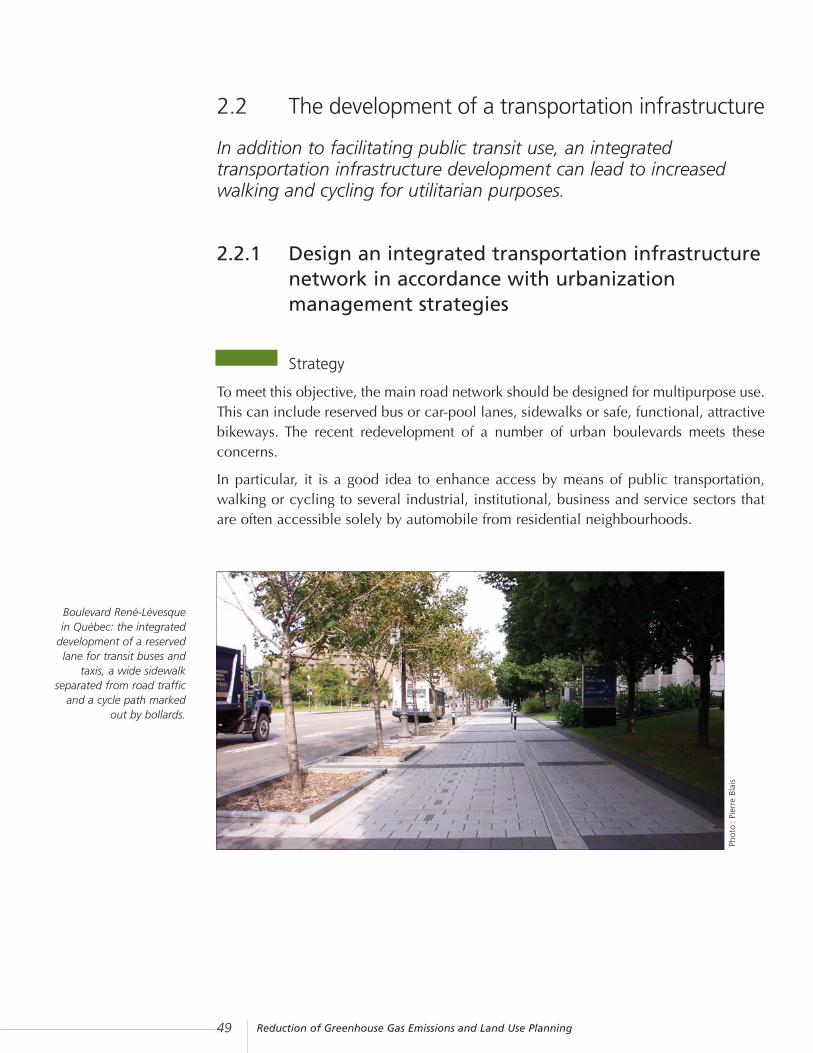
2.2 The development of a transportation infrastructure
In addition to facilitating public transit use, an integratedtransportation infrastructure development can lead to increasedwalking and cycling for utilitarian purposes.
2.2.1 Design an integrated transportation infrastructurenetwork in accordance with urbanizationmanagement strategies
Strategy
To meet this objective, the main road network should be designed for multipurpose use.This can include reserved bus or car-pool lanes, sidewalks or safe, functional, attractivebikeways. The recent redevelopment of a number of urban boulevards meets theseconcerns.
In particular, it is a good idea to enhance access by means of public transportation,walking or cycling to several industrial, institutional, business and service sectors thatare often accessible solely by automobile from residential neighbourhoods.
Boulevard René-Lévesque in Québec: the integrated
development of a reservedlane for transit buses and
taxis, a wide sidewalkseparated from road traffic
and a cycle path markedout by bollards.
Phot
o:
Pier
re B
lais

Reduction of Greenhouse Gas Emissions and Land Use Planning 50
Rue University in theQuartier international de
Montréal: development thatgives priority to pedestrians.
Local street networks
Let us now examine initiatives focusing on existing or planned local street networks,pedestrian promenades and bikeways.
The local street networks pattern of suburban residential areas where single-familydwellings prevail, developed over the past 30 years, differs from the conventionalsquare grid pattern: it is more hierarchical (e.g. one local street connects to anotherlocal street, which connects to a feeder road, which in turn connects to an arterial road),and the road layout is often more winding and personalized.
Specifically, this configuration aims to enhance peacefulness and safety on local roads,which handle much less through traffic, and to introduce greater variety in the routesleading to residences. However, it lengthens these routes, which does not encouragewalking, which is further discouraged by the lack of sidewalks.
Phot
o:
Jona
than
Pic
ard
(QIM
)
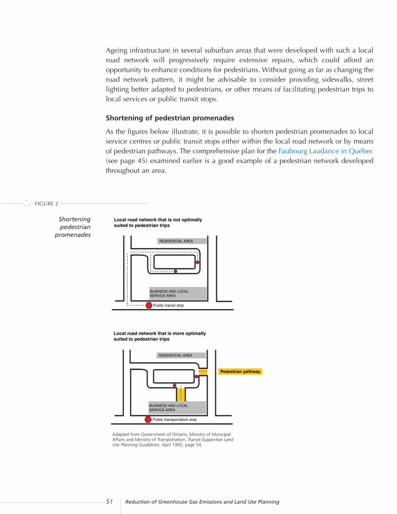
Reduction of Greenhouse Gas Emissions and Land Use Planning51
Ageing infrastructure in several suburban areas that were developed with such a localroad network will progressively require extensive repairs, which could afford anopportunity to enhance conditions for pedestrians. Without going as far as changing theroad network pattern, it might be advisable to consider providing sidewalks, streetlighting better adapted to pedestrians, or other means of facilitating pedestrian trips tolocal services or public transit stops.
Shortening of pedestrian promenades
As the figures below illustrate, it is possible to shorten pedestrian promenades to localservice centres or public transit stops either within the local road network or by meansof pedestrian pathways. The comprehensive plan for the Faubourg Laudance in Québec(see page 45) examined earlier is a good example of a pedestrian network developedthroughout an area.
Local road network that is not optimally suited to pedestrian trips
RESIDENTIAL AREA
BUSINESS AND LOCALSERVICE AREA
Public transit stop
FIGURE 2
Adapted from Government of Ontario, Ministry of MunicipalAffairs and Ministry of Transportation, Transit-Supportive LandUse Planning Guidelines, April 1992, page 54.
Shorteningpedestrian
promenades
Local road network that is more optimally suited to pedestrian trips
RESIDENTIAL AREA
Pedestrian pathway
BUSINESS AND LOCALSERVICE AREA
Public transportation stop
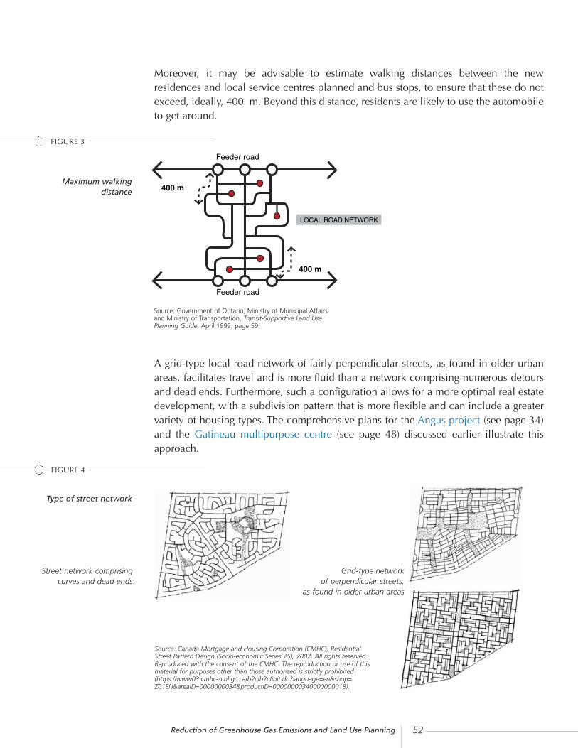
Reduction of Greenhouse Gas Emissions and Land Use Planning 52
Feeder road
Feeder road
LOCAL ROAD NETWORK
Source: Government of Ontario, Ministry of Municipal Affairsand Ministry of Transportation, Transit-Supportive Land UsePlanning Guide, April 1992, page 59.
Moreover, it may be advisable to estimate walking distances between the newresidences and local service centres planned and bus stops, to ensure that these do notexceed, ideally, 400 m. Beyond this distance, residents are likely to use the automobileto get around.
A grid-type local road network of fairly perpendicular streets, as found in older urbanareas, facilitates travel and is more fluid than a network comprising numerous detoursand dead ends. Furthermore, such a configuration allows for a more optimal real estatedevelopment, with a subdivision pattern that is more flexible and can include a greatervariety of housing types. The comprehensive plans for the Angus project (see page 34)and the Gatineau multipurpose centre (see page 48) discussed earlier illustrate thisapproach.
Type of street network
FIGURE 3
Maximum walkingdistance
Source: Canada Mortgage and Housing Corporation (CMHC), ResidentialStreet Pattern Design (Socio-economic Series 75), 2002. All rights reserved.Reproduced with the consent of the CMHC. The reproduction or use of thismaterial for purposes other than those authorized is strictly prohibited(https://www03.cmhc-schl.gc.ca/b2c/b2c/init.do?language=en&shop=Z01EN&areaID=0000000034&productID=00000000340000000018).
FIGURE 4
Grid-type network of perpendicular streets,
as found in older urban areas
Street network comprisingcurves and dead ends
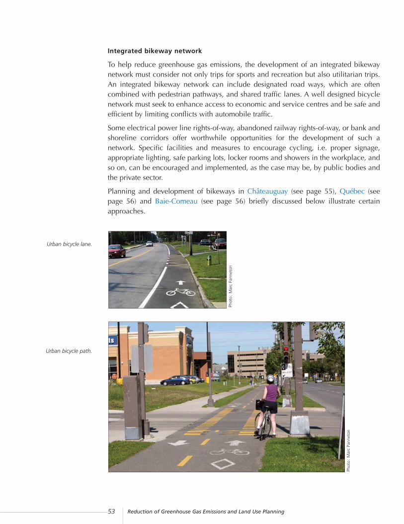
Reduction of Greenhouse Gas Emissions and Land Use Planning53
Integrated bikeway network
To help reduce greenhouse gas emissions, the development of an integrated bikewaynetwork must consider not only trips for sports and recreation but also utilitarian trips.An integrated bikeway network can include designated road ways, which are oftencombined with pedestrian pathways, and shared traffic lanes. A well designed bicyclenetwork must seek to enhance access to economic and service centres and be safe andefficient by limiting conflicts with automobile traffic.
Some electrical power line rights-of-way, abandoned railway rights-of-way, or bank andshoreline corridors offer worthwhile opportunities for the development of such anetwork. Specific facilities and measures to encourage cycling, i.e. proper signage,appropriate lighting, safe parking lots, locker rooms and showers in the workplace, andso on, can be encouraged and implemented, as the case may be, by public bodies andthe private sector.
Planning and development of bikeways in Châteauguay (see page 55), Québec (seepage 56) and Baie-Comeau (see page 56) briefly discussed below illustrate certainapproaches.
Urban bicycle lane.
Urban bicycle path.Ph
oto
: M
arc
Pann
eton
Phot
o:
Mar
c Pa
nnet
on

Reduction of Greenhouse Gas Emissions and Land Use Planning 54
Means of action
Planning tools
Transportation infrastructure planning must be thoroughly developed in the municipalplanning programme. To this end, it is important that the programme adhere to theprinciple of integrated transportation infrastructure development, which, while ensuringadequate service throughout the area, is also aimed at reducing greenhouse gasemissions.
Based on this principle, planning must first include a diagnosis that reveals, inparticular, shortcomings that need to be remedied to foster travel by means other thanthe automobile. The diagnosis leads to the definition of policies and standards governingthe development of future infrastructure in the areas to be urbanized and infrastructureimprovement projects in urbanized zones. It can also determine the layout of certaininfrastructures or define, if appropriate, criteria to be considered in a by-law concerningCDPs.
Regulatory tools
The planning programme objectives should lead to a review of the subdivision by-lawstandards relating to the road network layout and development. To facilitate its initiativesin regards to the integrated transportation network, the municipality will ultimately haveto consider an array of tools to ensure participation by developers in the developmentof the proposed network.
These tools include: the municipal agreements works by-law; the requirements that maybe imposed on developers concerning the implementation and funding of facilities orinfrastructure as provided for under the by-law concerning CDPs; or a contribution inrespect of parks, playgrounds and natural areas which may be used for pedestrian orbicycle pathways.

Reduction of Greenhouse Gas Emissions and Land Use Planning55
Châteauguay: Planning a bikeway network for the entire city
In the spring of 2002, the Ville de Châteauguay adopted a master plangoverning the bikeway network that it intends to develop in the comingyears. The plan defines the development principles and phases in thenetwork’s development. It addresses the needs stemming from thegrowing use of bicycles both for recreational and utilitarian purposes.Réseau cyclable Châteauguay, an organization extensively involved inthe promotion of cycling, worked closely with the city on this project.
The anticipated network includes two main routes that cross the cityfrom north to south within an electric power line right-of-way andalong the rivière Châteauguay. It also includes secondary routesdesigned to serve different areas and the main employment and servicecentres, including the industrial park.
For each section of the network, the master plan describes the preferredtype of bicycle lane to be implemented (bicycle lanes or paths, pavedshoulders or designated lanes), the work to be carried out and thetechnical standards that apply.
A cost estimate has been established for each phase of the network’sdevelopment, thus allowing the city to include the projects planned inits three-year capital expenditure programme.
Source : Ville de Gatineau
CASE STUDY

Reduction of Greenhouse Gas Emissions and Land Use Planning 56
Baie-Comeau: A strategic cycle path to better integrateurbanized areas
During the 1980s, the Ville de Baie-Comeau initiated the developmentof a bicycle path roughly 6 km long running along highway 138, inorder to improve cycling access between the Mingan area, in the west,and the Marquette area, in the east. The path improved the diversity ofaccess modes to the city’s major regional activity centres, such as themain malls, institutional centres and industries located in these areas.
In 1998, the path underwent major redevelopment in order to bettercombine business with pleasure. Work carried out to install municipalservices allowed the city to relocate sections of the path, further fromhighway 138, and take advantage of a more compact foundation. Therelocation also means that users enjoy a more attractive woodedenvironment.
Source : Ville de Baie-Comeau
Québec: The utilitarian nature of the bicycle path on chemin des Quatre-Bourgeois
The bicycle path on chemin des Quatre-Bourgeois, an urban boulevardin Québec, was planned specifically to foster utilitarian cycling.
The bicycle path runs along several medium- and high-densityresidential areas and gives users access to key activity centres,including Université Laval. The entire bikeway network defined in theformer Ville de Sainte-Foy cycling master plan will be connected to thisstructuring axis. This will result in a more efficient access to regionalemployment and service centres in this area of the new Ville deQuébec.
CASE STUDY
CASE STUDY

Reduction of Greenhouse Gas Emissions and Land Use Planning57
2.3 Urban forests
The reforestation of open spaces and enhanced protection forexisting green spaces make it possible to capture some CO2emissions.
2.3.1 Reforest open space and protect green spacesIn recent decades, urbanization has led to the loss of numerous hectares of green spacein urban centres. In support of the strategy to consolidate urbanization in order to limitthe production of greenhouse gas emissions, the greening of cities offers severaladvantages, both in terms of carbon regulation and the enhancement of the urban livingenvironment.
Strategy
The positive contribution made by trees
Through photosynthesis, trees capture carbon by fixing CO2 and removing it from theair. In addition to capturing CO2, trees contribute in three ways to the enhancement ofthe urban living environment.
The bicycle path on chemin des
Quatre-Bourgeois.
Source : Ville de Québec
The bicycle path on chemin des Quatre-Bourgeois is over 5 km inlength. It has been developed in light of the specific characteristics ofthis urban environment, i.e. limited space, numerous car ramps, busyintersections, road overpasses, and bus shelters. It was necessary tonarrow the traffic lane in order to implement the cycling path, which isalso designed to safely accommodate rollerbladers.
Phot
o:
Vill
e de
Qué
bec
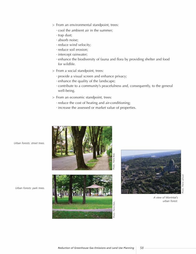
Reduction of Greenhouse Gas Emissions and Land Use Planning 58
> From an environmental standpoint, trees:
· cool the ambient air in the summer;· trap dust;· absorb noise;· reduce wind velocity;· reduce soil erosion;· intercept rainwater;· enhance the biodiversity of fauna and flora by providing shelter and food for wildlife.
> From a social standpoint, trees:
· provide a visual screen and enhance privacy;· enhance the quality of the landscape;· contribute to a community’s peacefulness and, consequently, to the general well-being.
> From an economic standpoint, trees:
· reduce the cost of heating and air-conditioning;· increase the assessed or market value of properties.
Urban forests: street trees.
Urban forests: park trees.
Phot
o:
Pier
re B
lais
Phot
o:
Pier
re B
lais
Phot
o:
Pier
re L
ahou
d
A view of Montréal’s urban forest.

Reduction of Greenhouse Gas Emissions and Land Use Planning59
Some statistics
> In urban environments, a 30-year-oldtree on average stores 9.4 kg of carbonper year. It thus takes 130 trees to storethe 4,500 kg that an automobileproduces while travelling 20,000 kmper year.*
> A sound layout of trees and shrubsaround a house can reduce winterheating costs by up to 15% andsummer air-conditioning costs by up to50%. The same is true of properlyarranged windbreaks, which canreduce from 10% to 25% theconsumption of home heating fuel inthe winter.**
> Several studies show that the presenceof trees on developed and unde-veloped lots increases the value of theproperties. Most of the studies put theincrease in value at between 7% and15%.***
Sources:* Société de l’arbre du Québec, Des arbres pour vivre ensanté : guide pour la realisation de projets de plantation,1998, page 5.** Société internationale d’arboriculture — Québec inc.,Guide d’évaluation des végétaux d’ornement, 1995, page 4.*** Id., pages 9-10.Christian Faubert and Jean Canonne, “La valeur de l’arbreurbain” in L’actualité immobilière, Vol. XVII, No. 2(summer), 1993, pages 40-41.
Urban reforestation
Greening strategies for urban areas focus both on the reforestation of open spaces andenhanced protection for existing green spaces. From the standpoint of reforestation,municipalities can define planting policies, programmes or projects considering allpublic and private spaces that offer an appropriate environment for tree growth.
The targeted spaces can be small or large:
> residential lots in old and new areas;
> street and boulevard rights-of-way, in the median and along the street line;
> green spaces such as parks or shorelines;
> institutional, commercial and industrial zones, especially parking lots, turfed plantbeds, and the areas surrounding buildings;
> abandoned or unstructured areas in urban and peri-urban environments that areunderutilized, such as brownfields, farm woodlots or former extraction sites.

Reduction of Greenhouse Gas Emissions and Land Use Planning 60
To improve the survival rate of trees, it is important to follow the principle of the righttree in the right place given the numerous constraints to tree planting in an urbanenvironment. If possible, an attempt should also be made to link green spaces to fostergreater biodiversity while avoiding the isolation of trees, which increases theirvulnerability.
From the standpoint of the protection of the urban forest, municipal policies can protectwoodlands of interest from urban development. They can also control deforestation.
Means of action
Planning tools
As for development and urban planning tools, following the example of the other actionareas, it is advisable to include guidelines respecting reforestation and the protection ofgreen spaces in the municipality’s planning programme and, as warranted, in the RCM’sland use planning and development plan or in the development criteria in a municipalby-law concerning CDPs.
These guidelines should be linked to a more operational policy governing urban forestryand green spaces, which can include an inventory, an assessment and an annual ormulti-year action plan that specifies the action spheres, the objectives to be attained,and evaluation and follow-up measures.
Regulatory tools
Urban planning by-laws may include zoning provisions to regulate the felling of treesor the obligation to plant trees when buildings are erected.
A by-law concerning SPAIPs can also include criteria to ensure the harmoniousintegration of development projects into the natural environment and reduce theanticipated environmental impact. Such criteria can focus on components such asvegetation screens or wooded buffer zones, landscaping of sites after buildings areerected, or preservation of certain trees depending on their location, health, diameter,and so on.
The urban forest can also benefit from measures defined by the RCM in a by-law on theplanting and felling of trees.

Reduction of Greenhouse Gas Emissions and Land Use Planning61
Aside from these regulatory controls, the municipality can acquire land for the purposeof establishing parks, green spaces or the preservation and planting of greenery. Suchland purchases and plantings can be funded by means of the contribution in respect ofparks, playgrounds and natural areas, which can be paid when an application issubmitted for a subdivision or building permit.
Urban forestry committee
The implementation of a policy governing urban forestry and the preservation of greenspaces can benefit considerably from the contribution made by various communitystakeholders. The establishment of a committee that includes residents can guide andsupport the municipality’s initiatives by highlighting public concerns and, incidentally,by providing expertise.
An urban forestry and conservation committee can be tasked with elaborating a policyand an action plan, evaluating development projects, and heightening publicawareness. Moreover, it can also be advantageous to work with communityorganizations dedicated to the conservation or planting of trees.
Brief descriptions of the experience of Québec (see page 62), Montréal (see page 64),Victoriaville (see page 66), Saint-Georges (see page 67), Sainte-Adèle (see page 68) andRouyn-Noranda (see page 68) illustrate how this type of approach is implemented.

Reduction of Greenhouse Gas Emissions and Land Use Planning 62
Québec: A master plan for the natural environment and urban forests
The Ville de Québec has, over the past 20 years, assumed leadership inthe realm of urban forests by adopting two five-year plans in thisrespect and by innovating in a number of ways in the field. By 2006,the city will have adopted a master plan to protect and develop itsnatural environment and urban forests.
The urban forest in the Montcalm area
in Québec.
Since the initiation of the plan’s implementation, various communitystakeholders such as non-profit organizations, NGOs and governmentdepartments, have worked closely together in order to take advantageof each one’s expertise. The master plan will, in particular, pursue fourobjectives.
1. Inventory natural environments of great value located in the city,describe each of the selected entities and define its potential. In theVille de Québec, the types of natural environments include:
> urban forests: all trees planted individually or preserved in theurban environment, i.e. street, park and other trees;
> urban woods: an ecosystem in which trees predominate and allstrata of vegetation are represented, often located on formerfarmland or sites unsuited to development because of rocky cliffs,the proximity of waterways, and so on;
> forest estates: a vast area that supports a wide array of foreststands, often located on the periphery of the city;
> water bodies, riparian areas, lake shores, and natural environ-ments, which provide important wildlife and plant habitats.
CASE STUDY
Phot
o:
Vill
e de
Qué
bec

Reduction of Greenhouse Gas Emissions and Land Use Planning63
2. Define protection measures and establish strategies adapted to eachtype of environment, including:
> reviewing by-laws governing the felling of trees and forestharvesting;
> defining criteria that promote the preservation of existing treeswhen development projects are carried out;
> increasing the number and area of protected natural environ-ments;
> examining the possibility of establishing a protected area zoningto ensure better protection of environments of great value.
3. Complete a computerized inventory of urban forests throughout thecity’s territory.
4. Evaluate and adapt as needed the tree planting programmes now ineffect:
> planting on the remaining portions of rights-of-way in front ofresidences;
> cost-sharing of tree planting on residential or commercial lots, inindustrial parks and on school grounds;
> establishing parks and green spaces, including projects such asthe naturalization of the banks of the Rivière Saint-Charles andthe reforestation of abandoned or derelict municipal lots;
> redeveloping streets, such as the transformation of big boulevardsand narrowing of roads to increase the areas for planting;
> planting when parking lots are eliminated in front of properties;> reforestation of hardly developed or undeveloped asphalted lots
and open spaces along streets, with the collaboration ofinterested residents, in densely built central areas.
The urban forest along the Rivière Saint-Charles
in the Ville de Québec.
Phot
o:
Vill
e de
Qué
bec
Source : Ville de Québec

Reduction of Greenhouse Gas Emissions and Land Use Planning 64
Montréal: Green space protection on Île-des-Soeurs
In order to preserve the initial garden city concept and the outstandingnatural environment of Île-des-Soeurs, the former Ville de Verdun, nowamalgamated into the new Ville de Montréal, was an advocate ofregulatory measures and partnerships aimed at ensuring thepreservation of the natural environment.
Moreover, from the very beginning, the urban design aimed atencouraging non vehicular trips by providing a network of parkwaysthat cross through the development zones, in order to make pedestrianwalking trips quicker and safer.
Protection of the Domaine Saint-Paul woodland
Within this context, mention should be made of the commitment of theborough and residents to preserve the Domaine Saint-Paul woodland,a 30-hectare natural site located in the centre of the Île-des-Soeursdistrict.
Starting in the late 1980s, the Ville de Verdun gradually acquired over80% (24 ha) of the woodland. Moreover, the Comité pour la protectiondu patrimoine naturel de l’Île-des-Soeurs purchased two additionalhectares, which it gave to the former Ville de Verdun, thus making itpossible to protect nearly 87% of the original woodland.
Moreover, in order to link the Domaine Saint-Paul to the Lachine rapidsmigratory bird sanctuary, the borough established a green corridorlinking the woodland to the St. Lawrence River. This corridor, locatedon the site of the future ecological golf course, has been created bytransplanting trees from the unprotected forest. The corridor fosters themobility of wildlife and thus supports biodiversity on the site.
Over the years, the former Ville de Verdun has also acquired more than22 000 m2 of river banks, doubling the width of public banks in orderto once again ensure the biomass preservation.
CASE STUDY

Reduction of Greenhouse Gas Emissions and Land Use Planning65
A set of specific measures
In its urban planning by-laws, the borough of Verdun applies specificprovisions in the residential zones adjacent to the Domaine Saint-Paulin order to foster reforestation, the protection of trees and the naturalenvironment. These provisions, which apply to lots adjacent to thewoodland, stipulate, among other things, the obligation to:
> plant one tree for every 25 m2 in the backyard;> preserve trees with a diameter of over 10 cm;> all trees with a diameter over 10 cm for which an authorization to
fell was granted must be replaced;> replace trees that were injured during construction;> plant an impenetrable hedge or install a gateless fence to prevent
access to the woodland.
Verdun’s planning programme, which was reviewed in 2000 andapproved by biologists and the ministère de l’Environnement duQuébec, consolidates the current situation by making provision forother measures centred on reforestation and the development of theurban forest throughout the built environment.
Moreover, the borough of Verdun has set up the Comité de gestion etde suivi des habitats naturels de Verdun, with a status that is similar tothat of an urban planning advisory committee, except that its mandateis to analyse and propose any initiative deemed relevant focusing onthe natural environment and to submit its recommendations to theborough council.
With respect to the contribution demanded of developers for thepurpose of establishing parks, play spaces and green spaces, it shouldbe noted that the city frequently accepts land in lieu of a financialcontribution. In this way, it impresses upon promoters the interest ofintegrating public green spaces into their projects.
One key achievement of the borough of Verdun is to have convinceddevelopers that a private riverbank only generates added value forshoreline residences while a public riverbank generates added valuefor all properties in the project, whether or not they are on the shore.
Source : Ville de Montréal

Reduction of Greenhouse Gas Emissions and Land Use Planning 66
Victoriaville: A well established urban forestry policy
In 1993, the Ville de Victoriaville established an urban forestry advisorycommittee with a view to defining and administering a city-wide urbanforestry policy. The committee is made up of seven members who areeither elected representatives, public servants or residents, includingexperts in horticulture. The Service de la gestion du territoire overseesregulatory questions pertaining to forestry and the Service del’environnement manages operations.
The committee formulates opinions on all questions related to urbanforestry. It studies, among other things, development projects in respectof which regulatory provisions governing the protection or planting oftrees must be administered. Under its mandate, it also develops urbanforestry projects. One of its first projects was to conduct a detailedinventory of the trees on municipal property.
It has also adopted annual action plans that describe reforestation,maintenance and awareness initiatives. Up until now, these actionplans have set for the city a planting objective of 200 trees per year onmunicipal property, i.e. in parks, along boulevards and on the median,as well as on private property.
Source : Ville de Victoriaville
CASE STUDY
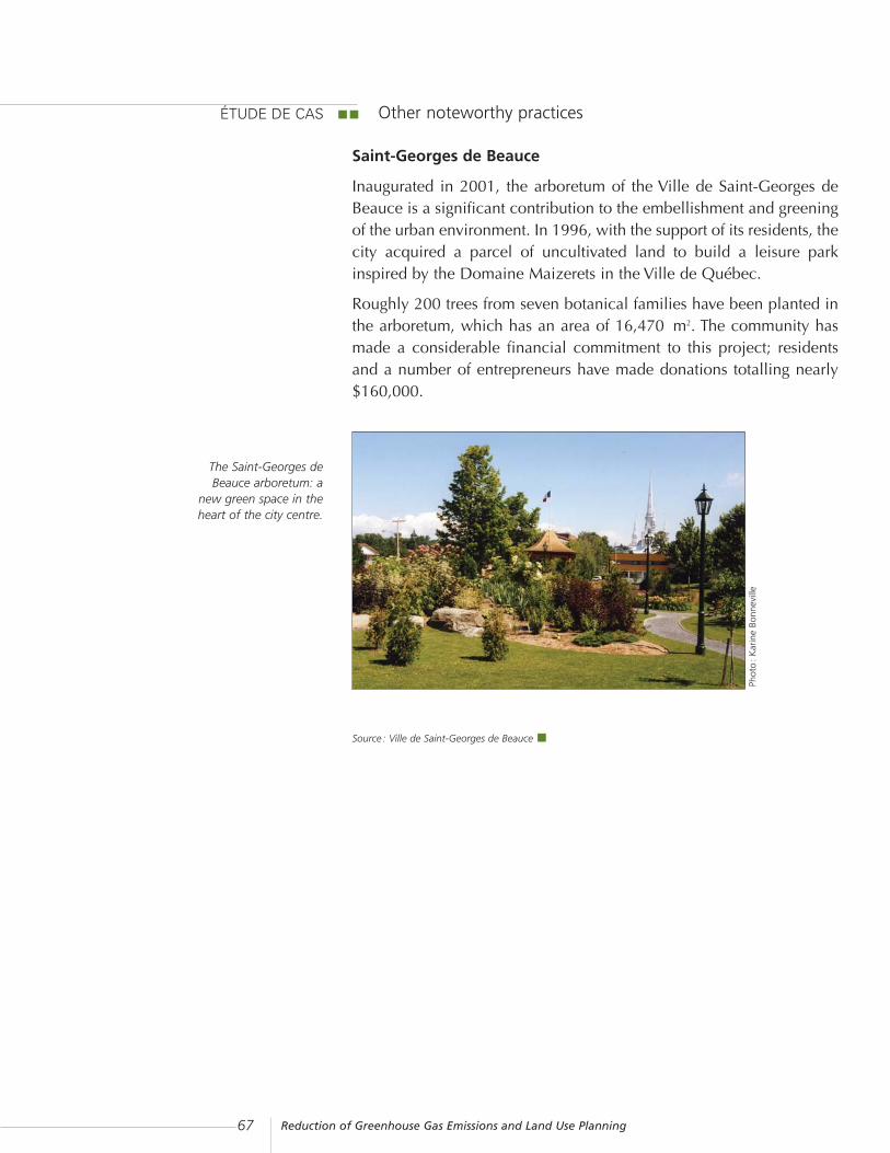
Reduction of Greenhouse Gas Emissions and Land Use Planning67
The Saint-Georges deBeauce arboretum: a
new green space in theheart of the city centre.
Other noteworthy practices
Saint-Georges de Beauce
Inaugurated in 2001, the arboretum of the Ville de Saint-Georges deBeauce is a significant contribution to the embellishment and greeningof the urban environment. In 1996, with the support of its residents, thecity acquired a parcel of uncultivated land to build a leisure parkinspired by the Domaine Maizerets in the Ville de Québec.
Roughly 200 trees from seven botanical families have been planted inthe arboretum, which has an area of 16,470 m2. The community hasmade a considerable financial commitment to this project; residentsand a number of entrepreneurs have made donations totalling nearly$160,000.
Source : Ville de Saint-Georges de Beauce
ÉTUDE DE CAS
Phot
o:
Kar
ine
Bonn
evill
e

Reduction of Greenhouse Gas Emissions and Land Use Planning 68
Sainte-Adèle
Several stakeholders in Sainte-Adèle are helping to protect greenspaces and to plant trees. Mention should first be made of the Sociétéde protection foncière de Sainte-Adèle, a non-profit organizationdedicated to the preservation of the natural environment, which hasacquired through purchase or donation several forests and wetlands.
The Ville de Saint-Adèle has contributed directly to the preservation ofnatural areas, in particular by donating several of its properties to theSociété de protection foncière de Sainte-Adèle, and by acquiringcertain sites to prevent building in sensitive areas located in the LacSainte-Adèle watershed.
Furthermore, another organization, Action Environnement Sainte-Adèle, has already planted several thousand trees and shrubs along theshores and elsewhere in the municipality.
Source : Municipalité de Sainte Adèle
Rouyn-Noranda
The Ville de Rouyn-Noranda has increased the area covered bywoodlands in conjunction with the rebuilding of streets and alleys. Theprogramme, which was first developed to reduce the cost ofmaintaining and rebuilding several streets that were overly wide fortraffic and parking, made it possible to reduce by 20 m the road right-of-way to a width of 10 m to 15 m, depending on the type of street.
Sidewalks, benches and medians on nearly 15 streets have increasedthe space available for planting, for pedestrians, and for landscaping.Since 1995, the number of trees in the city has increased from 4,000 to5,000, mainly along streets.
Source : Municipalité de Rouyn-Noranda

Reduction of Greenhouse Gas Emissions and Land Use Planning69
BIBLIOGRAPHYBLAIS, Pierre. Aperçu de tendances émergentes en matière d’urbanisation dans les grandesagglomérations américaines – revue de littérature [online]. Québec: ministère des Affaires municipales,du Sport et du Loisir, Observatoire municipal, April 2000, 20 pages[http://www.mamr.gouv.qc.ca/publications/obse_muni/tendances_emergentes.pdf]
DESBIENS, Émilie. Manuel de foresterie urbaine : la gestion des arbres et des espaces boisés dans lesmunicipalités du Québec. Québec: ministère de l’environnement, Direction du patrimoine écologique,“Les guides verts” collection, one volume (looseleaf), 1987.
DESPRÉS, Carole, Andrée FORTIN and Geneviève VACHON. La banlieue revisitée. Québec: ÉditionsNota bene, 2002, 302 pages.
HYDRO-QUÉBEC. Énergie et aménagement du territoire, 1995, 61 pages.
LITMAN, Todd. Evaluating Transportation Land Use Impacts [online]. Victoria: Victoria Transport PolicyInstitute, October 2003, 67 pages [http://www.vtpi.org/landuse.pdf]
ONTARIO, Ministry of Municpal Affairs and Ministry of Transportation. Transit-Supportive Land UsePlanning Guidelines [online], April 1992, 119 pages[http://www.mah.gov.on.ca/userfiles/page_attachments/business/transuppguid/transuppguid-e.pdf]
PRONOVOST, Jean-François. Les sentiers du 21e siècle : planification, design et gestion des sentierspolyvalents. Montréal: Vélo Québec, 1995, 223 pages.
QUÉBEC, Comité interministériel sur les changements climatiques. Problématique des transports et deschangements climatiques au Québec – Rapport du groupe de travail sur les transports, November 1999,146 pages.
QUÉBEC, Comité interministériel sur les changements climatiques. Rapport du groupe de travail surl’aménagement du territoire, January 2000, 142 pages.
QUÉBEC. Québec Action Plan on Climate Change 2000-2002 [online], 2000, 42 pages[http://www.mddep.gouv.qc.ca/changements/plan_action/plan-action.pdf]
QUÉBEC, Agence de l’efficacité énergétique and Ministère de l’Environnement du Québec. Je lève lepied, je réduis les gaz ! (educational tool to evaluate greenhouse gas emissions according to the mode oftransportation), 2001.
QUÉBEC, ministère des Ressources naturelles. Évolution de la demande d’énergie et des émissions degaz à effet de serre au Québec : scénario de référence 1996-2001, [online], May 2001, 51 pages[http://www.mrnfp.gouv.qc.ca/publications/energie/energie/20014012.pdf]
QUÉBEC, ministère des Affaires municipales, du Sport et du Loisir. La prise de décision en urbanisme(3rd edition), 2004 [online][http://www.mamr.gouv.qc.ca/amenagement/outils/amen_outi_avan.htm]
SMART GROWTH BC. The Smart Growth Toolkit: helping to create more liveable communities in BritishColumbia. Vancouver, 2001, 152 pages.
VILLENEUVE, Claude and François Richard. Vivre les changements climatiques : l’effet de serre expliqué.Sainte-Foy: Éditions MultiMondes, 2002, 274 pages.
VIVRE EN VILLE. Vers des collectivités viables. Sillery: Septentrion, 2001, 383 pages.

Reduction of Greenhouse Gas Emissions and Land Use Planning 70
GLOSSARY OF TERMS USED IN THE ACT RESPECTING LANDUSE PLANNING AND DEVELOPMENT
ACT RESPECTING LAND USE PLANNING AND DEVELOPMENT (RSQ, C. A-19.1)
The Act respecting land use planning and development establishes the legal frameworkfor the preparation and administration of rules governing land use planning anddevelopment in Québec.
GOVERNMENT LAND USE PLANNING ORIENTATIONS
One feature of the Act respecting land use planning and development is the nature ofthe government’s involvement in the overall planning process. The government adoptsland use planning policy statements that regional authorities must consider when theyprepare planning documents. Moreover, the government, its ministers and mandatariesare bound by the objectives set out in the land use planning and development plans inforce.
The government analyses the proposed reviewed plans submitted in light of its policystatements. The Minister of Municipal Affairs and Regions is responsible for the Act’sadministration, ensuring compliance with government land use planning policystatements, and authorizing the coming into force of the planning documents submitted.It is incumbent upon the Minister to ensure the coordination of sector-based opinionsand to present concerted opinions stemming from an analysis of departmental opinionsexpressed in light of the government’s position.
PLANNING TOOLS
Planning tools make it possible to engage in land use planning in a municipality, aregional country municipality (RCM) or a metropolitan community.
At the supramunicipal and regional level, the land use planning and development planincludes the following components: a strategic vision; the general aims of the land useand development policy; the urbanization perimeters and priority development zones;a land transportation plan; infrastructure and equipment planning; intermunicipaldevelopment proposals and areas of interest; the action plan in respect of the land useplanning and development plan; and the territorial development plan.
At the municipal level, the planning tools provided by the Act respecting land useplanning and development include the planning programme and the special planningprogramme.

Reduction of Greenhouse Gas Emissions and Land Use Planning71
Below are brief descriptions of these tools and their components.
· Land use planning and development plan (s. 5 to 7)The land use planning and development plan is the planning document thatestablishes guidelines governing the physical organization of a regional countymunicipality (RCM) or a metropolitan community. The plan coordinates choices anddecisions that affect all of the municipalities concerned, the government and itsdepartments and mandataries. Above all, the plan is a document of intent formulatedand designed to highlight a regional perspective of economic, social andenvironmental development.
· Strategic vision (s. 5,9°)A land use planning and development plan must set out a strategic vision of cultural,economic, environmental and social development to support coherent action by thethe regional county municipality or the metropolitan community.
· Urbanization perimeters, priority development zones and priority redevelopmentzones (s. 5,3° and 6,1°)The RCM or the metropolitan community must in its land use planning anddevelopment plan delimit urbanization perimeters, including already urbanized areasand those in which it intends to allow new urban growth. It may also determine thezones that will be developed or redeveloped first within an urbanization perimeter.
· General policies of land use (s. 5,2°)It is compulsory to adopt general aims for the land use policy that indicate what theRCM, the metropolitan community or the municipality intends for the different areasto be used.
· Equipment and infrastructure planning (s. 5,8°)The land use planning and development plan must indicate the nature and location ofmajor existing or planned new infrastructure and equipment.The inclusion of an infrastructure and equipment section in the land use planning anddevelopment plan makes it possible to ensure the maintenance, enhancement andestablishment of equipment and public or private public services in urbanized areas.Such planning promotes the use and accessibility of such services and favours theiroptimal location.
· Plan of the organization of land transport (s. 5,7°)The inclusion of a land transport section in the land use planning and developmentplan allows the regional county municipalities (RCMs) or metropolitan communities toconduct integrated planning of ground, air and maritime transport equipment andinfrastructure. Such planning also makes it possible establish links with other sectionsof the plan that affect or are affected by transport and to foster cooperation amongvarious actors.
· Action plan in respect of the land use planning and development plan (s. 7)The action plan is a document to implement the land use planning and developmentplan centred on initiatives pertaining to land use planning and development in anRCM.

Reduction of Greenhouse Gas Emissions and Land Use Planning 72
· Territorial development plan (s. 79.20)The territorial development plan makes it possible to pinpoint and structure thecommunity, economic, social and cultural development measures adopted in respectof an RCM.
· Planning programme (s.83 and 84)The planning programme is the planning document that sets out guidelines for amunicipality’s spatial and physical organization and establishes the municipality’sgeneral development vision for its territory.
· Special planning programme (s. 85 and 85.1)The special planning programme is a component of the planning programme whichfocuses more specifically on the planning of certain areas that demand specialattention from the municipal council, e.g. the development of a new residential orindustrial sector or of the city centre.
URBAN PLANNING BY-LAWS
Urban planning by-laws make it possible to establish rules, standards and evaluationcriteria governing construction and the use of buildings and land in a territory. They arethe key tools for the implementation of the choices and decisions concerning thecommunity’s future development that appear in the planning program and the land useplanning and development plan. They guide most land use planning and developmentoperations. Urban planning by-laws are directly enforceable against residents.
Below are brief descriptions of some of these by-laws.
· Zoning bylaw (s. 113)The zoning by-law divides the municipal territory into zones, sectors of zones or partsto control land and building use and regulate the construction and appearance ofstructures.
· Subdivision by-law (s. 115)Through its subdivision by-law, a municipality may define standards and conditionsgoverning the parceling and identification of lots.
· Construction by-law(s. 118)The construction by-law establishes construction quality standards and ensures theadequate solidity, resistance, sanitation, safety and insulation of a structure. It allows amunicipality to legislate in respect of buildings but solely in order to adopt higherstandards than those of the Québec Building Code or standards for buildings orcomponents not covered by this code.
· Comprehensive development programme (s. 145.9 to 145.14)The comprehensive development programme by-law makes it possible to requiredetailed planning in respect of certain areas before any amendment is made to thezoning by-law. This more flexible approach to project assessment based on criteriarather than standards fosters the search for innovative solutions in an open exchangebetween the municipality and the developers.
Reduction of Greenhouse Gas Emissions and Land Use Planning73
· Site planning and architectural integration programmes (s.145.15 to 145.20)The site planning and architectural integration programmes (SPAIP) by-law mayidentify certain areas or categories of projects subject to a qualitative assessment whenan application for a permit or a certificate is submitted. This enables the municipalityto ensure the quality of site planning and architectural integration, while taking intoaccount the specific nature of each situation.
· Conditional uses (s. 145.31 to 145.35)As its name indicates, the conditional use by-law is intended to allow, under certainconditions, the establishment or exercise of a use in a zone determined by the zoningby-law.
· Quotas on similar or identical uses (s.113, 4.1°)The setting of quotas is aimed at stipulating by zone the maximum number of sitesdestined for identical or similar uses, including in a given building or site, theminimum distance that must separate such sites or the maximum floor or lot area thatmay be destined for such uses.
· Specific construction, alteration or occupancy proposals for an immovable (s. 145.36 to 145.40)The by-law concerning specific construction, alteration or occupancy proposals for animmovable is aimed at allowing, under certain conditions, a project to be carried outdespite its departing from any of the municipality’s urban planning by-laws.
· Preliminary programme concerning the reuse of land freed up by demolitionThe by-law governing demolition may stipulate that the property owner must submitfor approval to the demolition committee a preliminary programme concerning thereuse of land freed up by demolition prior to an examination of his application for apermit. The by-law may also stipulate that, if the programme is approved, the propertyowner must submit to the municipality, prior to the issuing of his permit, a financialguarantee in respect of the execution of the programme in an amount not exceedingthe value recorded on the assessment role of the building to be demolished.
· Felling and planting of trees (s. 79.1 to 79.19)A municipality or an RCM may govern or restrict the planting or felling of trees toensure the protection of forest cover and foster the sustainable development of privateforests.
· Minor exemptions to urban planning by-laws (s. 145.1 to 145.8)The by-law concerning minor exemptions to urban planning by-laws allows for thegranting to an individual of an exemption in respect of the application of certainprovisions in the zoning by-law and the subdivision by-law and for the stipulation ofany condition, according to the municipality’s jurisdiction, with a view to mitigatingthe exemption’s impact.
· Interim control measures (s. 65 to 72 and 111 to 112.8)Interim control allows an RCM, a metropolitan community or a municipality, as thecase may be, to prohibit, restrict or govern the realization of new subdivision orconstruction projects or new uses of land when a land use planning and developmentplan or a planning program is prepared, modified or reviewed.
Reduction of Greenhouse Gas Emissions and Land Use Planning 74
LAND USE PLANNING FUNDING AND DIRECT MUNICIPAL ACTION
Funding and land-use control tools make it possible to establish funds and land banksor financial reserves in respect of impending investments. Through such tools,developers may be asked to participate in certain municipal works. Moreover, throughthese tools, groups of individuals or individuals can be encouraged to participatefinancially in order to support certain initiatives in a municipality.
Municipalities may also directly support the construction, maintenance oradministration of equipment, infrastructure or public services or may encourageproperty owners to build, renovate and develop their properties or buildings.
Below are brief descriptions of some of these tools.
· Municipal works agreements (s. 145.21 to 145.30)The by-law concerning municipal works agreements allows municipalities to concludeagreements with real estate developers regarding their participation in the costs andimplementation of the municipal works required to carry out development projects.
· Contribution in respect of parks, playgrounds and natural areas (s. 117.1 to 117.16)The contribution in respect of parks allows a municipality to impose on the propertyowner, as a condition for issuing a construction or subdivision permit, a levy, i.e. eitherthe property owner transfers free of charge to the municipality a property or he pays asum equivalent to the value of the property to be transferred, suitable for theestablishment or expansion of a park or playground or for the preservation of a naturalarea.
· Land banks and powers to acquire an immovableA municipality may, pursuant to its powers to acquire and dispose of immovables andland, facilitate the development of public and, in some instances, private projects.
The three types of powers of acquisition and disposal, whose conditions vary, are:· the acquisition programme in respect of immovables in the city centre and acquisitionsnot stipulated by the programme;
· acquisitions in respect of social and health services;· acquisitions in respect of land banks or housing banks.
A local municipality may possess immovables for the purpose of a land bank. It mayalso possess immovables for the purpose of housing. The municipality may lease suchan immovable, convert it and install public services there, demolish, transport orrestore a construction erected there, or erect a construction there. Notwithstanding anyirreconcilable provision and pursuant to these powers, the municipality may alsodispose at no cost for the benefit of certain establishments of an immovable obtainedfrom the government, one of its ministers or agencies, a regional county municipality,the municipal housing office, or another non-profit organization.

Reduction of Greenhouse Gas Emissions and Land Use Planning75
· Financial assistanceA municipality may, pursuant to its powers, grant direct financial assistance toindividuals and organizations with a view to fostering private initiatives or assisting theneedy.
For example, a municipality may:- offer tax incentives in respect of the construction, renovation or transformation ofbuildings and the development of land in conjunction with a revitalizationprogramme;
- establish a public housing development fund in order to support social housingdevelopment projects;
- set up or help set up certain non-profit organizations, give them grants or offer themguarantees and assign to them on its behalf the management of certain activities.
NOTE: The Act respecting land use planning and development (RSQ, C. 1-19.1) isavailable online, in English, on the Publications du Québec Web site athttp://www.publicationsduquebec.gouv.qc.ca/accueil.en.html, in the sectionon publications.

Reduction of Greenhouse Gas Emissions and Land Use Planning 76
GLOSSARY OF TERMS PERTAINING TO GREENHOUSE GASESGases governed by the Kyoto Protocol
Carbon dioxide:
Carbon dioxide (CO2) is an odourless, colourless, non-toxic gas normally found in theatmosphere. The combustion of fossil fuels is the main anthropogenic source of CO2.
Methane:
Methane (CH4) is a colourless, odourless gas that results from the fermentation ofbacteria in the absence of oxygen. It is the main component of natural gas. It isproduced by the decomposition of organic matter such as waste and animal digestion.
Nitrous oxide:
Nitrous oxide (N2O) is a colourless gas that is produced by the combustion of fossil fuelsand biomass, and by the use of fertilizers.
Hydrofluorocarbons:
Hydrofluorocarbons are a family of chemical compounds containing atoms ofhydrogen, fluorine and carbon. The chemical gases in this family, includinghydrofluorocarbons, sulphur hexafluoride and perfluorocarbons, are used for theirrefrigerating properties, as propellants in aerosols, and as solvents.
Other definitions
Carbon sink:
Carbon sink is the absorption of CO2 and its long-term containment. Forests and oceansare carbon sinks.
Smog:
Smog is a yellowish fog stemming from a mixture of airborne pollutants made up, aboveall, of fine particles and ozone, more precisely tropospheric or ground-level ozone (O3).It results from complex photochemical reactions between nitrogen oxides (NOx) andvolatile organic compounds (VOCs), pollutants stemming primarily from motorvehicles, industrial processes and heating. A smog episode can last from several hoursto one week. Its intensity depends on certain meteorological conditions such assunshine, temperature and wind, the time of day, the season and the distance from thesources of pollutants.

Reduction of Greenhouse Gas Emissions and Land Use Planning77