Best Practices for Managing Historical Imagery Cody Benkelman Kumar Dhruv.
22
Best Practices for Managing Historical Imagery Cody Benkelman Kumar Dhruv
-
Upload
clarence-fox -
Category
Documents
-
view
219 -
download
0
Transcript of Best Practices for Managing Historical Imagery Cody Benkelman Kumar Dhruv.

Best Practices for Managing Historical Imagery
Cody Benkelman
Kumar Dhruv
Objectives
• Manage & Share Collections of Historic imagery
• View & use best imagery- By geography
- By date, other attributes
• Initial product is mosaic dataset or image service with approximate georeferencing- Accuracy may be improved, depending on metadata and priority
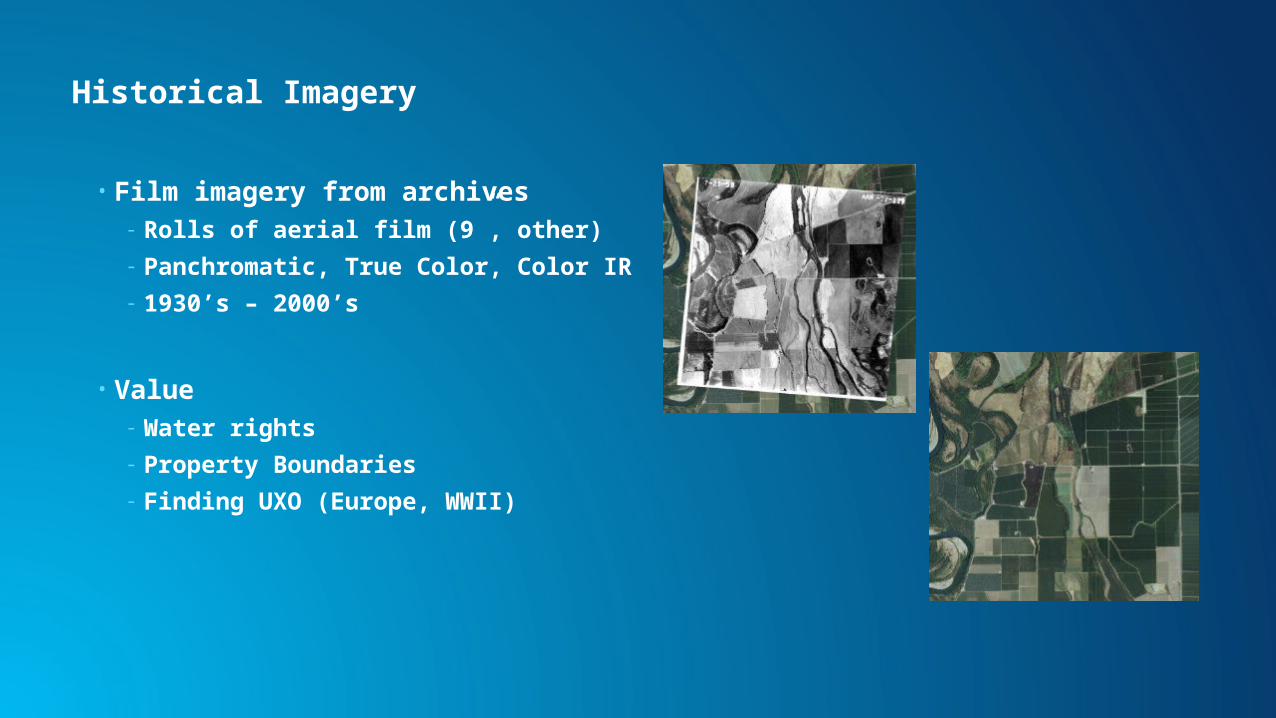
Historical Imagery
• Film imagery from archives- Rolls of aerial film (9”, other)
- Panchromatic, True Color, Color IR
- 1930’s – 2000’s
• Value - Water rights
- Property Boundaries
- Finding UXO (Europe, WWII)

Data Sources
• Typically scanned by- Photogrammetric scanner
- Table top scanner
• Scan quality sometimes poor
• Often Pan, sometimes color RGB
• Orientation & Metadata- None
- Poor – Just Index Map
- Good – Digital Index from navigation data (> 1990)
- Excellent – Output from AT

Simple Workflow (manual, small # of images)
• Scan
• Compile metadata
• Manual georeferencing- Details on following slide
• Mosaic Dataset- Raster Dataset Raster Type
• Optionally Refine Orientation
• Use directly in ArcGIS for Desktop
• Publish as Image Service

Manual Georeferencing - Details
• Set TIF images to ReadOnly
• Use ArcGIS Georeferencing Tool- Manually measure tie points using imagery base map
- Typically 6 spread out are sufficient
- Use Projective Transform
- Automated tie point may work (if similar base imagery is available)
• Use “Update Georeferencing”- Do NOT rectify and output

Manual Georeferencing

High Level Workflow (large/multiple projects automation)
1. Scan
2. Compile metadata, create feature class with approximate photo centers
3. Calculate approximate orientation
Many steps involved; See GP Tools available for download: http://www.esriurl.com/HistoricalTools
4. Mosaic Dataset
Frame Camera Raster Type
5. Optionally Refine Orientation
6. Use directly in ArcGIS for Desktop and/or Publish as Image Service

(1) Scanning & Optimum Format
• Scan at about 20 microns
• Record scan direction • Optimize Compression
- TIF with JPEG compression (Q80 ~ 5x)
- If color use JPEG_YCbCr (Q80 ~ 8x)
• No need to generate statistics
• Generate Pyramids- Often Internal (GDALaddo)
• To optimize format use CopyRaster or Raster to Other Format (Multiple)
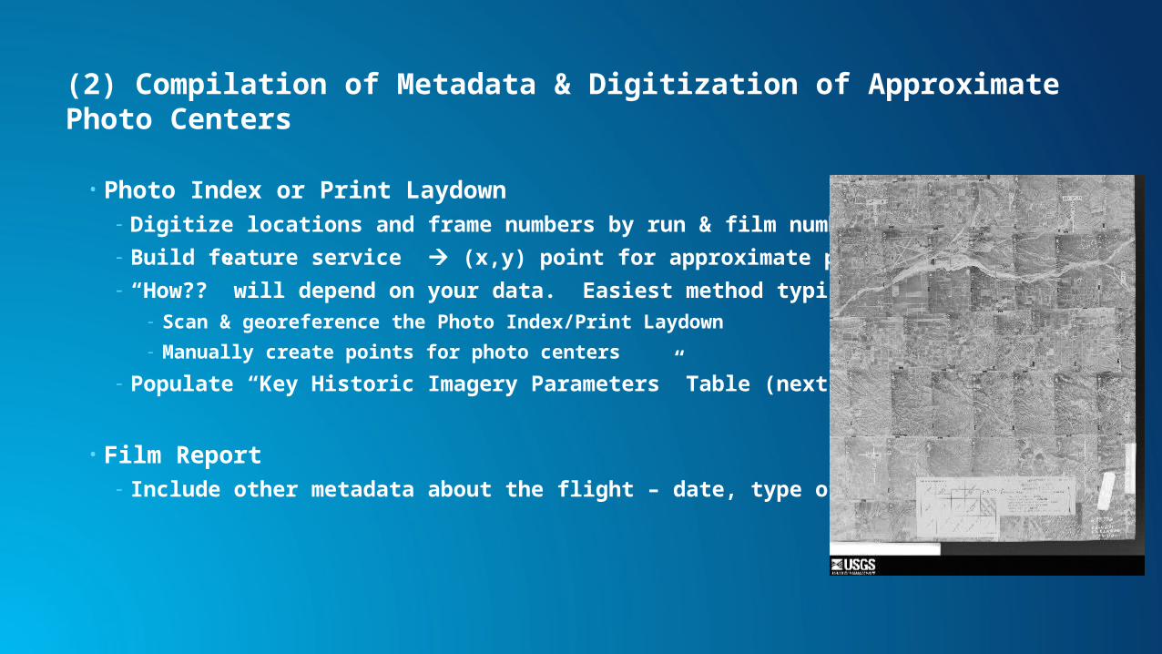
(2) Compilation of Metadata & Digitization of Approximate Photo Centers
• Photo Index or Print Laydown- Digitize locations and frame numbers by run & film number
- Build feature service (x,y) point for approximate photo center
- “How??” will depend on your data. Easiest method typically to: - Scan & georeference the Photo Index/Print Laydown
- Manually create points for photo centers
- Populate “Key Historic Imagery Parameters” Table (next slide)
• Film Report- Include other metadata about the flight – date, type of film, etc.
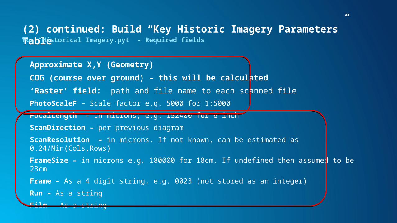
(2) continued: Build “Key Historic Imagery Parameters” TableFor “Historical Imagery.pyt” - Required fields
Approximate X,Y (Geometry)
COG (course over ground) – this will be calculated
‘Raster’ field: path and file name to each scanned file
PhotoScaleF – Scale factor e.g. 5000 for 1:5000
FocalLength - In microns; e.g. 152400 for 6 inch
ScanDirection – per previous diagram
ScanResolution – in microns. If not known, can be estimated as 0.24/Min(Cols,Rows)
FrameSize – in microns e.g. 180000 for 18cm. If undefined then assumed to be 23cm
Frame – As a 4 digit string, e.g. 0023 (not stored as an integer)
Run – As a string
Film – As a string

(2) continued: Build “Key Historic Imagery Parameters” TableFor “Historical Imagery.pyt” - Optional fields
Cols,Rows – Number of Cols and Rows of the image. Will be obtained from Image if not defined
OffsetC, OffsetR - in microns. This is the offset of the camera center from the center of the scan. If undefined then assumed to be 0.
Other parameters optional – from Film Report
e.g. AcquisitionDate, ScanDate, ScannerModel, FilmType, etc.
Frame Camera Raster Type will add to attribute table
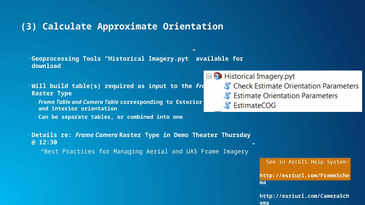
(3) Calculate Approximate Orientation
• Geoprocessing Tools “Historical Imagery.pyt” available for download
• Will build table(s) required as input to the Frame Camera Raster Type- Frame Table and Camera Table corresponding to Exterior orientation and
Interior orientation
- Can be separate tables, or combined into one
• Details re: Frame Camera Raster Type in Demo Theater Thursday @ 12:30
“Best Practices for Managing Aerial and UAS Frame Imagery”
See in ArcGIS Help System: http://esriurl.com/FrameSchema http://esriurl.com/CameraSchema
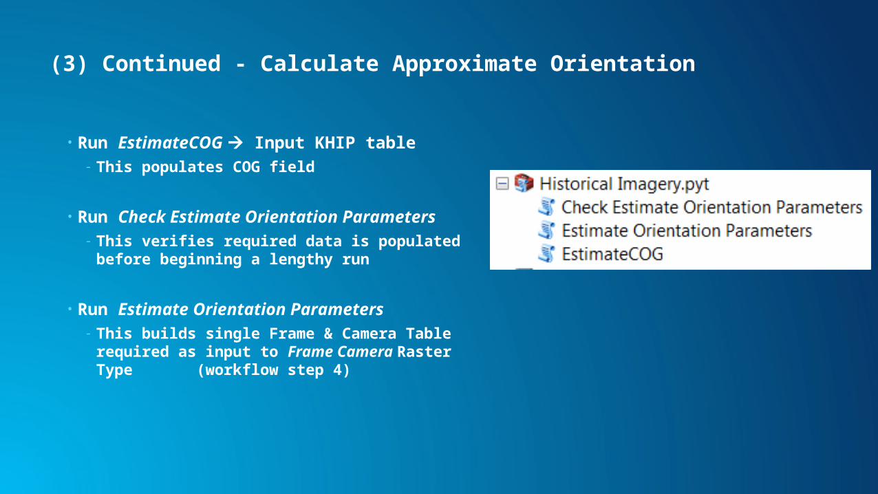
(3) Continued - Calculate Approximate Orientation
• Run EstimateCOG Input KHIP table- This populates COG field
• Run Check Estimate Orientation Parameters- This verifies required data is populated before
beginning a lengthy run
• Run Estimate Orientation Parameters- This builds single Frame & Camera Table required as
input to Frame Camera Raster Type (workflow step 4)
(4) Create Mosaic Dataset
• Use Frame Camera Raster Type- Input Frame+Camera table as input
• Calculate footprints by Geometry, shrink ~200 m, clip to footprints
• Set Mosaic Method = Closest to Center
• Create Overviews
Approximate Orientation using the Frame Camera Raster Type
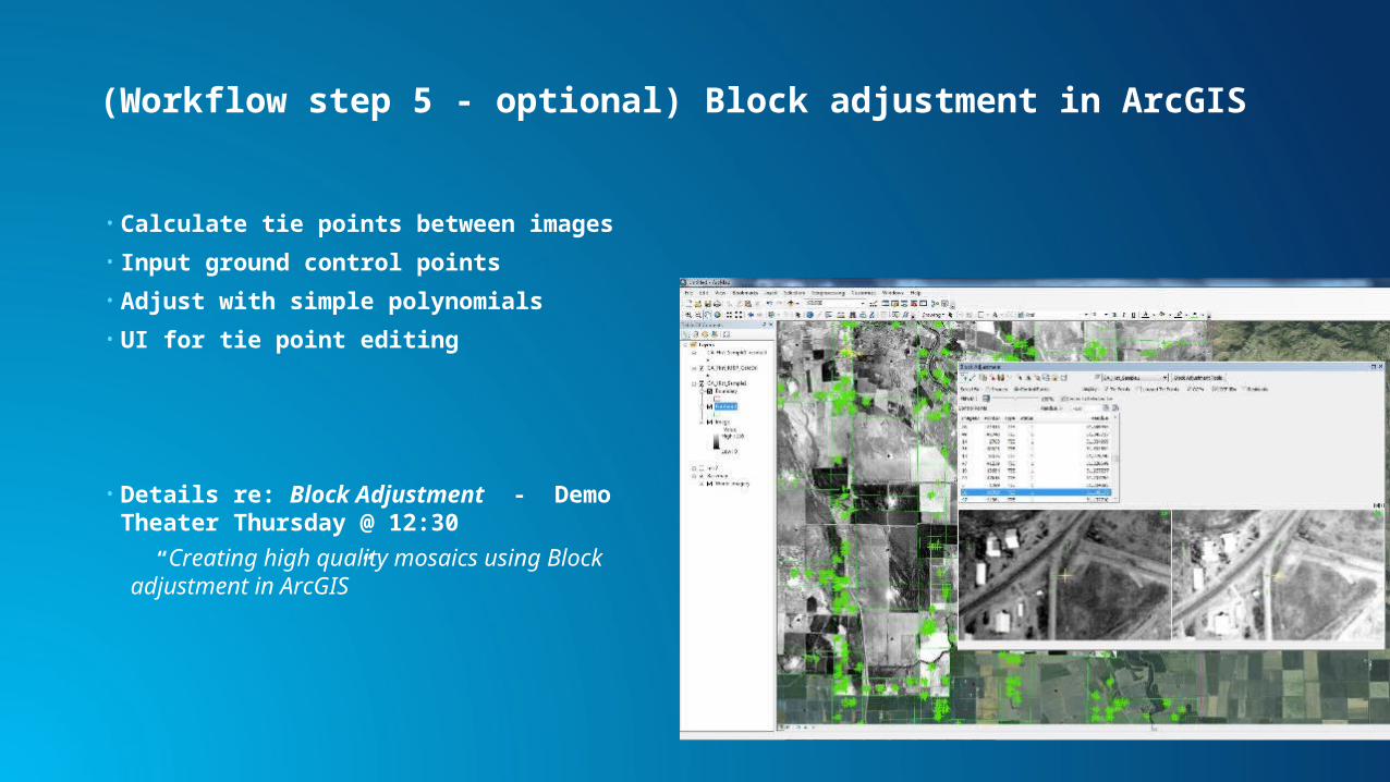
(Workflow step 5 - optional) Block adjustment in ArcGIS
• Calculate tie points between images
• Input ground control points
• Adjust with simple polynomials
• UI for tie point editing
• Details re: Block Adjustment - Demo Theater Thursday @ 12:30
“Creating high quality mosaics using Block adjustment in ArcGIS”

Refine Orientation using Block Adjustment
Publishing (Workflow step 6)
• As Image Services- Highest Image Quality (No data loss)
- Provide Metadata
- Access to All Overlapping data
- Clip to Footprints
• As Raster Tile Cache (not generally recommended)- Generate in Desktop or Server
- Publish through Server or to ArcGIS Online
- Provides Static Backdrop
Highest Accuracy - Use Aerial Triangulation (Workflow step 3)
• Best for large collections (e.g. PCI HAP, Trimble Match AT)
• Aerial Triangulation (AT) & Block Adjustment- Best estimates of interior and exterior orientation parameters
• Uses best available DEM
• Outputs following parameters- Key Properties - ImageID,FocalLength
- Exterior Orientation - X,Y,Z,Omega,Phi,Kappa
- Interior Orientation - A0,A1,A2,B0,B1,B2
• Use Frame Camera Raster Type
• Link in other metadata

Image Management Workflows
• Resource Center landing page http://esriurl.com/6005
• Guidebook in Help System http://esriurl.com/6007
• ArcGIS Online Group http://esriurl.com/6539
- Downloadable scripts & sample data
• Historical Imagery Toolbox: http://esriurl.com/Historical
• Recorded webinar: http://esriurl.com/LTSImgMgmt
• Source code on GitHub
Best Practice Workflows for Image Management