Bayers Road / Highway 102 Corridor Study Component 3...
82
Bayers Road / Highway 102 Corridor Study Component 3 - Highway 107 Final Report March 2010 Department of Transportation and Infrastructure Renewal and The Halifax Regional Municipality Completed By: Stantec Consulting Ltd. in association with Stantec #: 20639 Final Report
Transcript of Bayers Road / Highway 102 Corridor Study Component 3...

Bayers Road / Highway 102 Corridor Study Component 3 - Highway 107 Final Report March 2010
Department of Transportation and Infrastructure Renewal and The Halifax Regional Municipality
Completed By:
Stantec Consulting Ltd.
in association with
Stantec #: 20639
Final Report
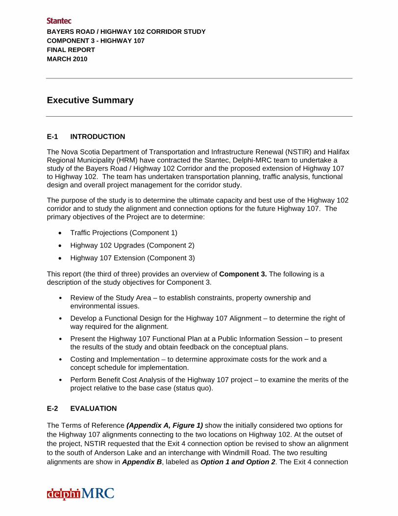
BAYERS ROAD / HIGHWAY 102 CORRIDOR STUDY COMPONENT 3 - HIGHWAY 107 FINAL REPORT MARCH 2010
Executive Summary
E-1 INTRODUCTION
The Nova Scotia Department of Transportation and Infrastructure Renewal (NSTIR) and Halifax Regional Municipality (HRM) have contracted the Stantec, Delphi-MRC team to undertake a study of the Bayers Road / Highway 102 Corridor and the proposed extension of Highway 107 to Highway 102. The team has undertaken transportation planning, traffic analysis, functional design and overall project management for the corridor study.
The purpose of the study is to determine the ultimate capacity and best use of the Highway 102 corridor and to study the alignment and connection options for the future Highway 107. The primary objectives of the Project are to determine:
• Traffic Projections (Component 1)
• Highway 102 Upgrades (Component 2)
• Highway 107 Extension (Component 3)
This report (the third of three) provides an overview of Component 3. The following is a description of the study objectives for Component 3.
• Review of the Study Area – to establish constraints, property ownership and environmental issues.
• Develop a Functional Design for the Highway 107 Alignment – to determine the right of way required for the alignment.
• Present the Highway 107 Functional Plan at a Public Information Session – to present the results of the study and obtain feedback on the conceptual plans.
• Costing and Implementation – to determine approximate costs for the work and a concept schedule for implementation.
• Perform Benefit Cost Analysis of the Highway 107 project – to examine the merits of the project relative to the base case (status quo).
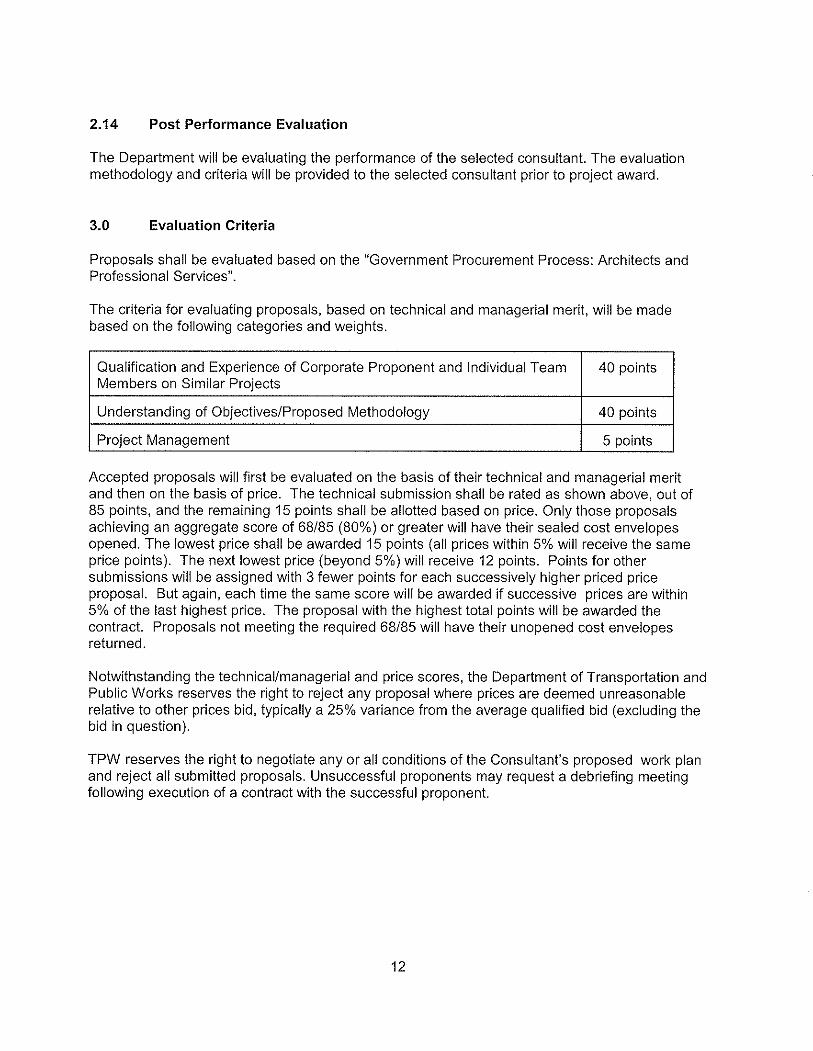
E-2 EVALUATION
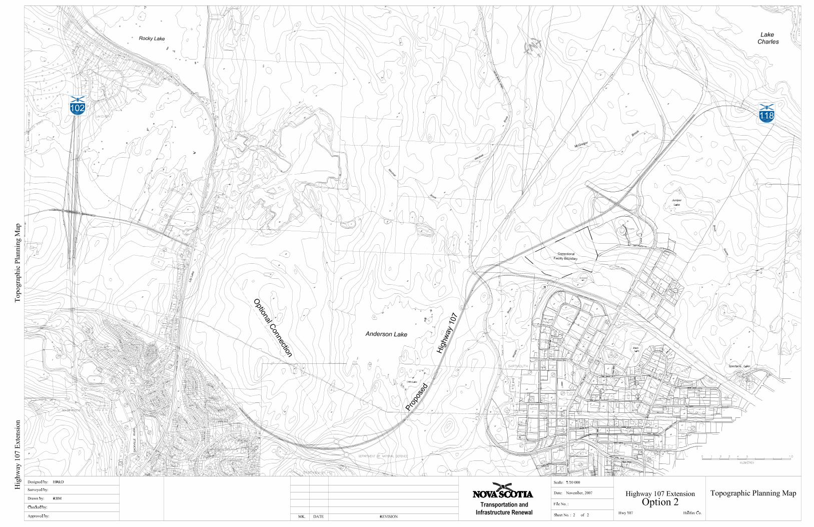
The Terms of Reference (Appendix A, Figure 1) show the initially considered two options for the Highway 107 alignments connecting to the two locations on Highway 102. At the outset of the project, NSTIR requested that the Exit 4 connection option be revised to show an alignment to the south of Anderson Lake and an interchange with Windmill Road. The two resulting alignments are show in Appendix B, labeled as Option 1 and Option 2. The Exit 4 connection

BAYERS ROAD / HIGHWAY 102 CORRIDOR STUDY COMPONENT 3 - HIGHWAY 107 FINAL REPORT MARCH 2010
E.2
option was carried forward in the Study as “Scenario C” and the connection was studied in a Value Engineering Session.
While the VE session presented many alternative connection configurations, it was apparent that a connection at Exit 4 which met the entire NSTIR criterion was not identified. A compromised solution would be required. With this in mind the two basic alignments for Highway 107 were reviewed and two key factors resulted in the selection of the preferred alternative:
- The lack of an acceptable design for a direct connection to Exit 4 as studied in the VE session (Component 2).
- The ability to phase the construction of the connection to Exit 4C. The suggested phasing is described in Section 3.0.
As a result, the Highway 107 alignment to the north of Lake Anderson and connection to Highway 102 at Exit 4C was determined to be the preferred and only feasible alignment which would be carried forward to functional design. It was also determined by NSTIR that the cost benefit analysis would compare this preferred alignment with the “do nothing” or status quo alternative.
Based on the preferred alignment, a review of background material was done in order to characterize the site and identify key constraints to extension of the highway. Background material reviewed included aerial photography, right-of-way plans, topographic and property mapping. A design criteria was established for the functional design of Highway 107 which is consistent with provincial standards for NSTIR 100 series highways.
E-3 FUNCTIONAL DESIGN
NSTIR prepared a plan showing the preferred alignment and three phased approach to construction. The resulting plan is shown in Appendix C, titled Highway 107 Extension - Option 1A. The plans show a suggested phasing of the highway development that would involve the facility operating as an arterial roadway prior to making the connections to the highways. The purpose of the phasing is to allow for funding of the project over a number of years.
- Phase 1: A 4-lane arterial road connection between Duke Street and Burnside Drive
- Phase 2: An interchange providing land access just to the west of Anderson Lake
- Phase 3: Westerly extension of Highway 107 to connect with Highway 102 and easterly extension of Highway 107 and connection to Akerley Boulevard

BAYERS ROAD / HIGHWAY 102 CORRIDOR STUDY COMPONENT 3 - HIGHWAY 107 FINAL REPORT MARCH 2010
E.3
Profiles were developed for each of the phases and associated ramps. Grading limits were generated using Civil 3D and based on the typical design section to determine the right-of-way that would be required.
E-6 SUPPLEMENTARY TRAFFIC EVALUATION
The study team carried out a supplementary evaluation to determine the feasibility of implementing a Burnside Drive extension (Phase 1, Arterial Road) concept, as opposed to constructing a 100-Series Freeway, and to determine approximately how far out into the future such a facility could accommodate traffic. The roadway concept is to extend Burnside Drive from its current terminus at Akerley Boulevard and connect to Duke Street at Rocky Lake Road. It was assumed that there would be major intersections with the arterial at Akerley and Rocky Lake Road and no other connection points. Evaluations were carried out for the 2016 and 2026 planning horizons for both the morning and afternoon peak hours. The general findings of the review indicate that:
• There is a strong desire for commuters to use this facility; • It could likely function as a 4-lane roadway (2 lanes in each direction) out to the 2026
planning horizon – the time about when it is forecast to reach capacity; • Two key constraint locations were identified as part of this analysis:
o Currently, The Highway 111/Burnside Drive interchange is approaching capacity. Given the potential for environmental and land use impacts in the immediate area, any upgrades may be difficult to undertake;
o The other constraint location is Akerley Boulevard where additional turning lanes may be required by the 2026 planning horizon;
• NSTIR expects the implementation of modern roundabouts will help address some of the challenges.
The second part of the supplemental evaluation of the Burnside Drive extension concept was to determine the impact to travel behaviour on parallel corridors. The roadways that are expected to experience a reduction in traffic volume as a result of a Burnside Drive extension include:
‐ Windmill Road / Magazine Hill; ‐ Highway 118 /Highway 102 through Fall River; and ‐ Highway 102 / Bedford Highway
The results identify and support the notion that there is a strong demand for a new roadway connection between Burnside Park and Highway 102 in the Bedford/Sackville area. The general travel behaviour changes that are expected to result from implementing the proposed Burnside Drive extension are illustrated in Exhibit E.1

BAYERS ROAD / HIGHWAY 102 CORRIDOR STUDY COMPONENT 3 - HIGHWAY 107 FINAL REPORT MARCH 2010
Exhibit E.1 Network Level Travel Behaviour Implications
E-7 SUMMARY AND CONCLUSIONS
The functional plans in Appendix C show the approximate right-of-way required for the construction of Highway 107 and the resulting properties which will be impacted by construction. An estimated 60 properties (see sketch with properties indicated) and 35 different property owners along the Highway 107 Corridor would be directly impacted by the construction.
Public Information Sessions were held to explain the study and obtain information and feedback from local residents, businesses, and landowners. Chapter 8.0 of the Component 2 report describes the sessions. From the questionnaires and comments received, it may be inferred that the majority of those who provided comments regarding the highway 107 project agree with
E.4

BAYERS ROAD / HIGHWAY 102 CORRIDOR STUDY COMPONENT 3 - HIGHWAY 107 FINAL REPORT MARCH 2010
E.5
the project. However, it was determined that careful consideration of the Highway 107 phase 1 is required. This phase would direct traffic directly to Glendale from the new Highway 107 and this has been identified as a primary concern.
Based on the functional design, the team prepared an opinion of capital costs for the major components of construction. Exhibit E.2 is an overall summary of the approximate costs for the proposed Highway 107 Extension. Exhibit E.2 – Highway 107 Cost Summary Table – by Phase
Item HIGHWAY 107 - SUMMARY No 1 - By Phase Approximate Cost 14.1 Phase 1 Highway 107 (Duke Street Extension) $47,000,00014.2 Phase 2 New Interchange on Highway 107 $0
14.3 Phase 3A - Highway 107 from Exit 4C to New Interchange (Westerly Connections) $28,000,000
14.4 Phase 3B - Highway 107 from Burnside Drive Interchange to Existing Hwy 107 $21,000,000
14.5 Phase 3C - Akerley Interchange $12,000,00012.3 Interchange: Highway 107 at Exit 4C (Option 1 Costing) $13,000,000
Total (excludes taxes, engineering, and contingencies) $121,000,000 The costs have been developed based on the limited information available as well as historical information. This is an order of magnitude estimate.
A conceptual timeline for the expansions has been determined and shown in Exhibit E.3. This approximate timeline shows the roadway phases as noted in Exhibit E.2. An approximate 2 year time frame is assumed for each component of the work.
Exhibit E.3 Timelines
Horizon Year 2016 Horizon Year 2026 Horizon Year 2036
No. Location 20
10
2011
20
12
2013
20
14
2015
20
16
2017
20
18
2019
20
20
2021
20
22
2023
20
24
2025
20
26
2027
20
28
2029
20
30
2031
20
32
2033
20
34
2035
20
36
HIGHWAY 107
14.1 Phase 1 Highway 107 (Duke Street Extension)
14.2 Phase 2 New Interchange on Highway 107
14.3 Phase 3A - Highway 107 from Exit 4C to New Interchange -
14.4 Phase 3B - Highway 107 from B Drive Int to Exis Hwy 107
14.5 Phase 3C - Akerley Interchange
12.3 Interchange: 107 at Exit 4C
BAYERS ROAD / HIGHWAY 102 CORRIDOR STUDY COMPONENT 3 - HIGHWAY 107 FINAL REPORT MARCH 2010
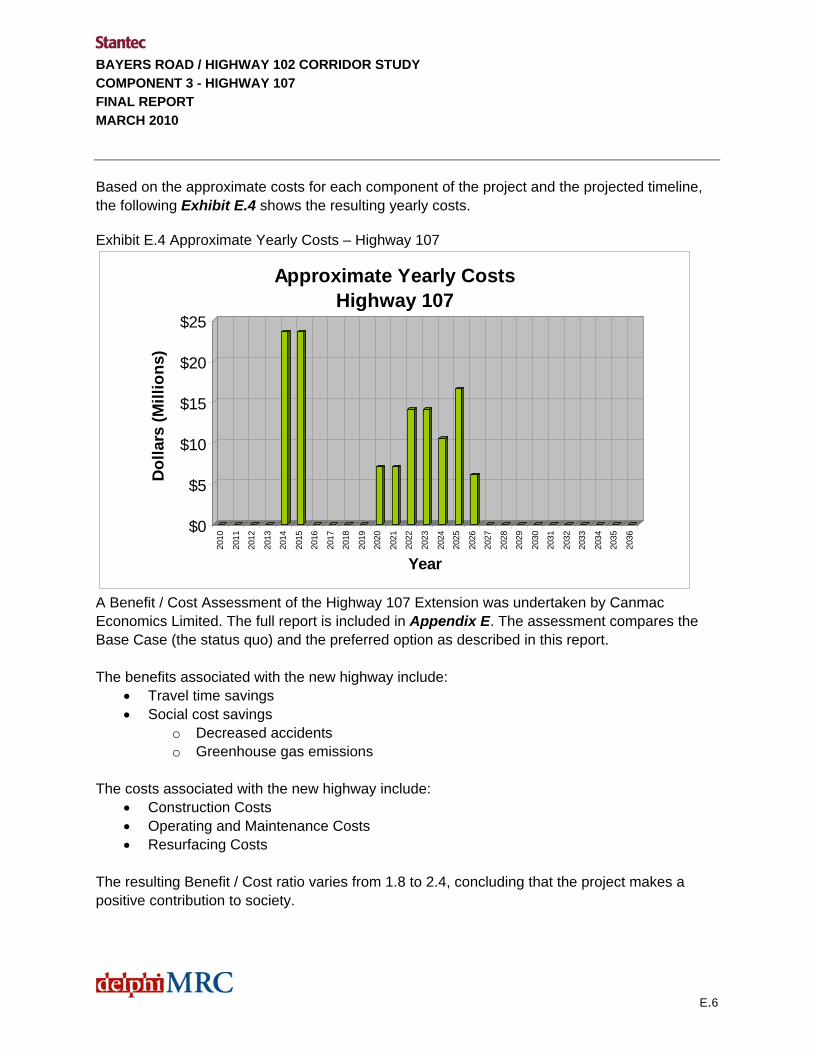
Based on the approximate costs for each component of the project and the projected timeline, the following Exhibit E.4 shows the resulting yearly costs.
Exhibit E.4 Approximate Yearly Costs – Highway 107
$0
$5
$10
$15
$20
$25
Dol
lars
(Mill
ions
)
2010
2011
2012
2013
2014
2015
2016
2017
2018
2019
2020
2021
2022
2023
2024
2025
2026
2027
2028
2029
2030
2031
2032
2033
2034
2035
2036
Year
Approximate Yearly CostsHighway 107
A Benefit / Cost Assessment of the Highway 107 Extension was undertaken by Canmac Economics Limited. The full report is included in Appendix E. The assessment compares the Base Case (the status quo) and the preferred option as described in this report. The benefits associated with the new highway include:
• Travel time savings • Social cost savings
o Decreased accidents o Greenhouse gas emissions
The costs associated with the new highway include:
• Construction Costs • Operating and Maintenance Costs • Resurfacing Costs
The resulting Benefit / Cost ratio varies from 1.8 to 2.4, concluding that the project makes a positive contribution to society.
E.6

BAYERS ROAD / HIGHWAY 102 CORRIDOR STUDY COMPONENT 3 - HIGHWAY 107 FINAL REPORT MARCH 2010
i
Table of Contents
EXECUTIVE SUMMARY E.1
1.0 INTRODUCTION ................................................................................................................1.1 1.1 BACKGROUND INFORMATION ........................................................................................1.1 1.2 OBJECTIVES FOR COMPONENT 3 – HIGHWAY 107 .....................................................1.2
2.0 EVALUATION.....................................................................................................................2.1 2.1 ALIGNMENT EVALUATION ...............................................................................................2.1 2.2 HIGHWAY 107 MAPPING ..................................................................................................2.2 2.3 HIGHWAY 107 DESIGN CRITERIA ...................................................................................2.3 2.4 GRADE SEPARATIONS AND INTERCHANGES ..............................................................2.4
3.0 CONCEPTUAL PLANS......................................................................................................3.1 3.1 CORRIDOR PLANNING.....................................................................................................3.1 3.2 PHASING............................................................................................................................3.1 3.3 FUNCTIONAL PLAN...........................................................................................................3.1
4.0 SUPPLEMENTARY TRAFFIC EVALUATION ...................................................................4.1 4.1 INTRODUCTION ................................................................................................................4.1 4.2 LINK VOLUME RESULTS ..................................................................................................4.2
4.2.1 Link Volume Results ............................................................................................4.2 4.2.2 Supplementary Network Level Review ................................................................4.4
4.3 STUDY AREA INTERSECTION EVALUATION .................................................................4.6 4.4 A NOTE ON THE HIGHWAY 102 CORRIDOR ..................................................................4.8
5.0 SUMMARY AND CONCLUSIONS .....................................................................................5.1 5.1 PROPERTY IMPACTS AND PUBLIC INFORMATION SESSIONS ...................................5.1 5.2 OPINION OF PROBABLE COST .......................................................................................5.2
5.2.1 Basis for the Costing............................................................................................5.2 5.2.2 Summary of Highway 107 Costs..........................................................................5.3
5.3 INFRASTRUCTURE IMPLEMENTATION SCHEDULE .....................................................5.4 5.3.1 Timeline for Expansions.......................................................................................5.4 5.3.2 Approximate Yearly Costs ...................................................................................5.5
5.4 BENEFIT / COST ASSESSMENT ......................................................................................5.5

BAYERS ROAD / HIGHWAY 102 CORRIDOR STUDY COMPONENT 3 - HIGHWAY 107 FINAL REPORT MARCH 2010
ii
APPENDICES APPENDIX A: Terms of Reference APPENDIX B: Alignment Options APPENDIX C: Functional Plans APPENDIX D: Costing APPENDIX E: Benefit / Cost Assessment

BAYERS ROAD / HIGHWAY 102 CORRIDOR STUDY COMPONENT 3 - HIGHWAY 107 FINAL REPORT MARCH 2010
sal 1.1
1.0 Introduction
The purpose of this study is to determine the ultimate capacity and best use of the Highway 102 corridor and to study the alignment and connection options for Highway 107. The primary objectives of the Project are to:
• Complete Traffic Projections for Highway 102 and 107 (Component 1)
• Identify Highway 102 Upgrades Requirements based on Component 1 (Component 2)
• Review the Highway 107 Extension to Highway 102 (Component 3)
The project is divided into three main components and specific objectives are discussed in Section 1.2. All three components are inter-related and portions of each component occurred concurrently. Component 1, the traffic projection component of the project provides the data required to complete Component 2 and 3 respectively. Traffic Projections have been determined using the QRSII model to the horizon years 2016, 2026, and 2036. The results of this work are summarized in “Component 1 – Traffic Projections Final Report”, February 20, 2008 and “Component 2 – Highway 102 Upgrades”, October, 2009.
The following report presents the results of Component 3 of the project – to identify a preferred alignment for the extension of Highway 107.
1.1 BACKGROUND INFORMATION
Previous work done over several years has identified the need for a 100 series highway connection from the existing Highway 107 connecting to Highway 102. The existing Highway 107 extends from Musquodoboit Harbour to the Westphal area of Dartmouth (Forest Hills Parkway) to Highway 118 and then to Akerley Boulevard in Burnside Park. The Akerley connection to the existing Highway 107 and Highway 118 was constructed with further extension in mind. The extension from Burnside Park to Highway 102 was originally planned and designed to connect to Exit 4C (Glendale / Duke Street) on Highway 102 and continue as the Second Lake Collector to connect to Highway 101 at an interchange to be located west of Sackville. Functional design work for the extension was done as far back as the 1970’s. Detailed design of the Exit 4C connection was completed in the 1990’s when the Glendale / Duke Street Interchange was constructed to allow for the Highway 107 Connection.

BAYERS ROAD / HIGHWAY 102 CORRIDOR STUDY COMPONENT 3 - HIGHWAY 107 FINAL REPORT MARCH 2010
1.2
However, The Second Lake Collector route has since been abandoned as a viable option. As a result, the planned alignment of Highway 107 between Burnside and Highway 102 is being re-examined to see if there is an opportunity to connect to Highway 102 at the Exit 4 (Bedford) interchange as an alternative to the Exit 4C connection. This would allow direct flow from Highway 107 to Highway 102 and Highway 101. As described in the Component 1 report (Section 2.4), Scenario B and Scenario C represented two options for the connection of Highway 107 to Highway 102 at Exit 4 and Exit 4C respectively. These options were evaluated with respect to Highway 102 traffic. Further, Component 2 of this project included a detailed review of the potential for a Highway 107 connection at Exit 4 through a Value Engineering (VE) process. The full report for the VE session is identified as Appendix J of the Component 2 Report. As well, Chapter 7 of the Component 2 Report provides a summary of the session and results. Given the two potential connection points, there are also two basic alignment options, to the north and to the south of Anderson Lake that were reviewed. Over recent years various plans have been developed for NSTIR as well as for private land owners. However, a consensus on the ultimate recommended location had not been achieved between the stakeholders.
1.2 OBJECTIVES FOR COMPONENT 3 – HIGHWAY 107
This report (the third of three) provides an overview of Component 3. The following is a description of the study objectives for Component 3.
• Review of the Study Area – to establish constraints, property ownership and environmental issues.
• Develop a Functional Design for the Highway 107 Alignment – to determine the right of way required for the alignment.
• Present the Highway 107 Functional Plan at a Public Information Session – to present the results of the study and obtain feedback on the conceptual plans.
• Costing and Implementation – to determine approximate costs for the work and a concept schedule for implementation.
• Perform Benefit Cost Analysis of the Highway 107 project – to examine the merits of the project relative to the base case (status quo).
The full project study area is shown on Figure 1.0.

BAYERS ROAD / HIGHWAY 102 CORRIDOR STUDY COMPONENT 3 - HIGHWAY 107 FINAL REPORT MARCH 2010
1.3

BAYERS ROAD / HIGHWAY 102 CORRIDOR STUDY COMPONENT 3 - HIGHWAY 107 FINAL REPORT MARCH 2010
2.1
2.0 Evaluation
2.1 ALIGNMENT EVALUATION
The Terms of Reference (Appendix A, Figure 1) show the initially considered two options for the Highway 107 alignments connecting to the two locations on Highway 102. Both options involved a corridor that was located to the north of Anderson Lake. The option connecting to Exit 4 would re-direct the Windmill Road traffic to Duke Street with a grade separated crossing of the new Highway 107.
At the outset of the project, NSTIR requested that the Exit 4 connection option be revised to show an alignment to the south of Anderson Lake and an interchange with Windmill Road. The two resulting alignments are show in Appendix B, labeled as Option 1 and Option 2. The Exit 4 connection option was carried forward in the Study as “Scenario C” and the connection was studied in a Value Engineering Session.
This VE study developed and evaluated a series of potential interchange configurations to be carried forward to the functional design stage of this project. As noted in the Component 2 report, “the VE study findings were intended to provide decision makers with information on a group of candidate design alternatives and specific design elements that appeared to the independent specialists of the VE Panel to offer significant value based on the evaluation criteria and weightings established for the study. The results also identify advantages and limitations associated with all of the scenarios examined”.
While the VE session presented many alternative connection configurations, it was apparent that a connection at Exit 4 which met the entire NSTIR criterion was not identified. A compromised solution would be required. With this in mind the two basic alignments for Highway 107 were reviewed.
A meeting was held to look at the alignments and to establish a plan that could be advanced to functional design. Various alternatives were presented for each basic option and two preferred alignments were chosen. The following is a summary of the options considered. The minutes of the meeting (March 7, 2008 Progress Meeting) which included sketches of the options is included in Appendix B.
• Option 1: Stantec presented an alternative to the Exit 4C connection option which recommended that the arterial road system be separate from the highway system. This is shown as “Option 1 Modified” in the March 7, 2008 Progress Meeting Minutes Appendix C. Three additional options were developed at the meeting and a preferred option, Option 1, Modified – (d) was selected as preferred by NSTIR and HRM.

BAYERS ROAD / HIGHWAY 102 CORRIDOR STUDY COMPONENT 3 - HIGHWAY 107 FINAL REPORT MARCH 2010
2.2
• Option 2: Stantec presented two alternatives to the Exit 4 connection option. These are shown as “Option 2 Modified (a) and (b)” in the Meeting Minutes in Appendix C. Three additional options were developed at the meeting and a preferred option (Option 2, Modified – (e) was selected as preferred by NSTIR and HRM.
Macro level costing was undertaken to compare the two selected alignments. The costing showed that while the cost of the Exit 4C connection alignment was less, it was only marginally less. The main reason being that each alignment would require a full reconstruction of the Bedford Interchange based on the projected traffic volumes. In effect the connection of Highway 107 to the Exit 4C location did not negate the need to reconstruct the Bedford interchange.
However, two key factors resulted in the selection of the preferred alternative:
• The lack of an acceptable design for a direct connection to Exit 4 as studied in the VE session (Component 2). This was a common problem for all of the Option 2 alternatives
• The ability to phase the construction of the connection to Exit 4C. The suggested phasing is described in Section 3.0
As a result, the Highway 107 alignment to the north of Lake Anderson and connection to Highway 102 at Exit 4C was determined to be the preferred and only feasible alignment which would be carried forward to functional design. It was also determined by NSTIR that the cost benefit analysis would compare this preferred alignment with the “do nothing” or status quo alternative.
2.2 HIGHWAY 107 MAPPING Based on the preferred alignment, a review of background material was done in order to characterize the site and identify key constraints to extension of the highway. Background material reviewed included aerial photography, right-of-way plans, topographic and property mapping. A digital terrain model (DTM) was developed using the available information. This material was obtained from HRM as well as from the Department of Transportation and Infrastructure Renewal.
An overall site plan and profile, showing constraints (in Appendix C) has been prepared showing:
• The current transportation corridor and right-of-way limits at either end of the proposed Highway 107 alignment
• Adjacent property owned by HRM • Adjacent property that is currently developed • Water bodies and water courses • Power Transmission lines
BAYERS ROAD / HIGHWAY 102 CORRIDOR STUDY COMPONENT 3 - HIGHWAY 107 FINAL REPORT MARCH 2010
2.3
• Trunk municipal infrastructure • Horizontal and vertical road geometry • Bridge structures • Rock outcrops and quarries • Active Transportation paths / bikeways
The constraints plan shows key municipal infrastructure as well as power transmission lines. Significant impact most likely will occur at interchange areas, where relocation of water lines or power lines will be required. The HRM Active Transportation Plan outlines a number of facilities required along the Highway 102 corridor including pedestrian, cyclists and multi-use trails. At Exit 4C a bikeway is suggested for the Glendale / Duke corridor which would extend across the top of Lake Anderson to connect with a proposed bikeway on Burnside Drive.
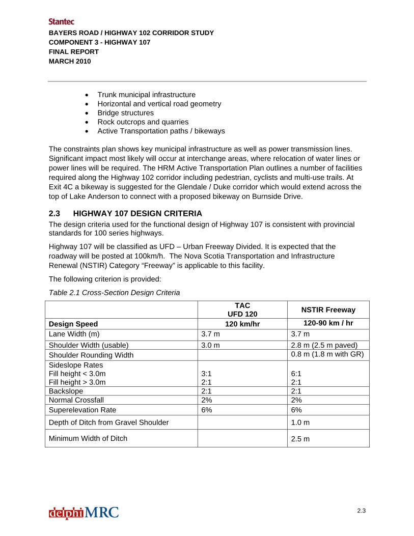
2.3 HIGHWAY 107 DESIGN CRITERIA The design criteria used for the functional design of Highway 107 is consistent with provincial standards for 100 series highways.
Highway 107 will be classified as UFD – Urban Freeway Divided. It is expected that the roadway will be posted at 100km/h. The Nova Scotia Transportation and Infrastructure Renewal (NSTIR) Category “Freeway” is applicable to this facility.
The following criterion is provided:
Table 2.1 Cross-Section Design Criteria
TAC UFD 120 NSTIR Freeway
Design Speed 120 km/hr 120-90 km / hr Lane Width (m) 3.7 m 3.7 m Shoulder Width (usable) 3.0 m 2.8 m (2.5 m paved) Shoulder Rounding Width 0.8 m (1.8 m with GR) Sideslope Rates Fill height < 3.0m Fill height > 3.0m
3:1 2:1
6:1 2:1
Backslope 2:1 2:1 Normal Crossfall 2% 2% Superelevation Rate 6% 6%
Depth of Ditch from Gravel Shoulder 1.0 m
Minimum Width of Ditch 2.5 m

BAYERS ROAD / HIGHWAY 102 CORRIDOR STUDY COMPONENT 3 - HIGHWAY 107 FINAL REPORT MARCH 2010
2.4
Table 2.2 Alignment Design Criteria
Roadway Classification TAC UFD 120 NSTIR Freeway
Minimum Radius (m) based on maximum superelevation of 6% (TAC Table 2.1.2.6)
750 m 750 m
Minimum Crest K (TAC Table 2.1.3.2)
Minimum Sag K (TAC Table 2.1.3.4) (headlight Control)
K (crest) = 150
K (sag) = 73
K (crest) = 105
K (sag) = 60
Minimum Longitudinal Grade
Maximum Longitudinal Grade 0.5%
3% (TAC Table 2.1.3.1) for UFD120, Rolling Topography
6% (NSTIR for Freeway)
Minimum Stopping Sight Distance (TAC Table 1.2.5.3)
290 m 290 m
The typical design section for Highway 107 is included in Appendix C. The typical section is used to establish property impacts. Grading limits have been developed at the conceptual level to determine property impacts.
2.4 GRADE SEPARATIONS AND INTERCHANGES
The Access Controlled Highway within the study area, from Exit 4C to Akerley Boulevard is approximately 7 km in total length with a total of six grade separations with arterial or local roadways. The following is a list of the crossings within the Highway 107 study area.
• Highway 107 / Highway 102 • Highway 107 / Existing Local Access Road • Highway 107 / Mann Street • Highway 107 / Rocky Lake Road • Highway 107 / New Arterial Roadway • Highway 107 / Burnside Drive • Highway 107 / Akerley Boulevard

BAYERS ROAD / HIGHWAY 102 CORRIDOR STUDY COMPONENT 3 - HIGHWAY 107 FINAL REPORT MARCH 2010
3.1
3.0 CONCEPTUAL PLANS
3.1 CORRIDOR PLANNING
NSTIR prepared a plan showing the preferred alignment and three phased approach to construction. Initially the alignment cut across the top of Anderson Lake which required a causeway and infill of a section of the Lake. This scheme was explored in order to avoid the Municipal Dexter Quarry area. However, the alignment was revised (moved to the north) to avoid any impact to Anderson Lake. This was done in consultation with NSTIR Environmental staff. Meetings were held between NSTIR and Municipal Dexter to discuss the alignment. An Environmental Assessment (EA) was undertaken in the past (approximately 10 years ago). While the alignment is similar, there are some changes and a new EA may be required. The resulting plan is shown in Appendix C, titled Highway 107 Extension - Option 1A.
3.2 PHASING
There is a suggested phasing of the highway development that would involve the facility operating as an arterial roadway prior to making the connections to the highways. Highway 102. The purpose of the phasing is to allow for funding of the project over a number of years.
- Phase 1: A 4-lane arterial road connection between Duke Street and Burnside Drive
- Phase 2: An interchange providing land access just to the west of Anderson Lake
- Phase 3: Westerly extension of Highway 107 to connect with Highway 102 and easterly extension of Highway 107 and connection to Akerley Boulevard.
3.3 FUNCTIONAL PLAN
Appendix C includes 1:5000 scale functional design plans for preferred Highway 107 alignment. Background mapping of existing conditions has been prepared using available provincial topographic mapping as well as digitizing the existing lane work based on 2003 and 2006 aerial photos. There is some distortion and therefore horizontal accuracy is limited. As a result the existing ground surface is based on available aerial mapping, which can be, approximately plus or minus 2.5 m in vertical accuracy and is, in some areas, out of date with respect to existing developments. It is important to note that the accuracy of the mapping has a direct impact on the accuracy of determining property impacts and costing of reconstruction. These impacts are key objectives for the study and will be evaluated at a conceptual level consistent with the data used.

BAYERS ROAD / HIGHWAY 102 CORRIDOR STUDY COMPONENT 3 - HIGHWAY 107 FINAL REPORT MARCH 2010
3.2
Profiles were developed for each of the phases and associated ramps. Grading limits were generated using Civil 3D and based on the typical design section. The following is a description of the functional plan:
- Phase 1: The four lane arterial would be constructed with a roundabout at Rocky Lake Road and then a grade separation over the CN Rail just to the east of Rocky Lake Road. A second CN rail crossing is required to the west of Anderson Lake. The arterial would provide the fourth leg of the intersection at Akerley and Burnside Drive.
- Phase 2: The interchange providing land access just to the west of Anderson Lake is shown as a diamond interchange with ramp connections both to Duke Street and Highway 107.
- Phase 3(a) Westerly Exit 4C Connection: The existing Glendale / Duke Street Interchange is a full movement diamond interchange. The interchange structure has been constructed to allow for additional auxiliary lanes on the freeway in anticipation of the future Highway 107 connection at this location. The addition of the Highway 107 ramps results in a three leg directional interchange that lies within the area of the Duke Street diamond interchange. From Exit 4C, grade separation structures would be provided at (i) an existing roadway just east of the 102, (ii) Mann Street and (iii) three level structure at Rocky Lake Road and CNR crossing. Ramps to / from the new Phase 1 and Phase 2 work would require 3 additional structures.
- Phase 3(b) Easterly extension to Akerley Boulevard: The Burnside Drive interchange ramps would be constructed as well as a Parclo interchange at Akerley Boulevard.
BAYERS ROAD / HIGHWAY 102 CORRIDOR STUDY COMPONENT 3 - HIGHWAY 107 FINAL REPORT MARCH 2010
4.1
4.0 Supplementary Traffic Evaluation
4.1 INTRODUCTION
This section presents the findings from the travel demand modeling of the proposed arterial roadway (phase1) which is the extension of Burnside Drive between Akerley Boulevard and Rocky Lake Road. This work is a supplementary analysis to the Highway 102/Bayers Road Corridor Study. The intent is to determine the longer-term impacts on the study area links and intersections as a direct result of implementing the proposed roadway, assuming that the Highway 113 and a third harbour crossing are not built within the planning horizon.
At the request of the NSTIR we carried out the following tasks:
• Applied the QRS II travel demand model developed for the Highway 102/Bayers Rd Corridor Study to test the proposed new roadway for the 2016 and 2026 AM and PM peak hours. The Scenario A road network was used as a baseline condition for this work.
• The NSTIR requested that peak hour link volumes be provided on 16 pre-defined study area links in the vicinity of the proposed new roadway. We have documented these volumes for the 2016 and 2026 AM and PM peak hours.
• The NSTIR requested that the following seven intersections be evaluated to determine the impacts at the 2016 and 2026 planning horizons as a result of the implementation of the proposed new roadway.
o Cobequid Road / Glendale Drive
o Rocky Lake Road / Duke Street
o Highway 102 SB ramps / Glendale-Duke
o Highway 102 NB ramps / Glendale-Duke
o Akerley Boulevard / Burnside Drive
o Highway 111 SB ramps / Burnside Drive
o Highway 111 NB ramps / Burnside Drive
For the purposes of this exercise, Glendale Drive, Duke Street, and Burnside Drive are assumed to have a general east-west alignment, and all intersecting roads and highway ramps are assumed to have a general north-south alignment.

BAYERS ROAD / HIGHWAY 102 CORRIDOR STUDY COMPONENT 3 - HIGHWAY 107 FINAL REPORT MARCH 2010
4.2
4.2 LINK VOLUME RESULTS
4.2.1 Link Volume Results
At the request of the NSTIR, peak hour link volume results have been documented for 16 pre-defined study area roadway links presumed to be impacted as a direct result of implementing the proposed Burnside Drive extension. The results indicate that there is a strong desire to use this facility and the forecast volumes are contained in Table 4.1.
Table 4.1: 2016 and 2026 Proposed Burnside Drive Extension Peak Hour Volumes
Proposed Burnside Dr Extension 2016
Horizon 2026
Horizon Westbound (to Sackville) 280 vph 310 vph AM
Peak Eastbound (to Burnside) 1,730 vph 2,010 vph Westbound (to Sackville) 1,620 vph 1,820 vph PM
Peak Eastbound (to Burnside) 570 vph 630 vph
All of the link volume results were collated and compared to the AM and PM peak hour 2001 baseline model results produced as part of the Highway 102/Bayers Road Corridor Study. The peak hour link volume results are documented in Tables 4.2 and 4.3 on the following page.

BAYERS ROAD / HIGHWAY 102 CORRIDOR STUDY COMPONENT 3 - HIGHWAY 107 FINAL REPORT MARCH 2010
4.3
Table 4.2: AM Peak hour Mid-block Volume Forecasts
2016 Horizon Results
(vph) 2026 Horizon Results
(vph)
Mid-Block Section
2001 Model
2016 with new link
Change in
Volume 2001
Model
2026 with new link
Change in
Volume
Proposed Burnside Dr Extension (WB) ~ 280 ~ ~ 310 ~ Proposed Burnside Dr Extension (EB) ~ 1,730 ~ ~ 2,010 ~ Burnside Dr west of Hwy 111 (WB) 980 1,280 300 980 1,470 490 Burnside Dr west of Hwy 111 (EB) 1,010 670 -340 1,010 730 -280 Akerley Dr north of Burnside (NB) 510 580 70 510 660 150 Akerley Dr north of Burnside (SB) 2,080 1,260 -820 2,080 1,410 -670 Akerley Dr south of Burnside (NB) 250 220 -30 250 280 30 Akerley Dr south of Burnside (SB) 1,310 990 -320 1,310 1,220 -90 Rocky Lake Dr south of Duke (NB) 20 240 220 20 360 340 Rocky Lake Dr south of Duke (SB) 40 70 30 40 80 40 Duke St east of Hwy 102 (WB) 50 250 200 50 290 240 Duke St east of Hwy 102 (EB) 140 1,910 1,770 140 2,120 1,980 Glendale Ave east of Cobequid (WB) 90 160 70 90 190 100 Glendale Ave east of Cobequid (EB) 660 800 140 660 820 160 Glendale Ave west of Cobequid (WB) 280 270 -10 280 310 30 Glendale Ave west of Cobequid (EB) 840 980 140 840 1,020 180 Cobequid Rd north of Glendale (NB) 190 220 30 190 250 60 Cobequid Rd north of Glendale (SB) 220 210 -10 220 180 -40 Cobequid Rd south of Glendale (NB) 300 290 -10 300 320 20 Cobequid Rd south of Glendale (SB) 330 340 10 330 320 -10 Hwy 102/101 WB to SB ramp (NW quad) 60 70 10 60 80 20 Hwy 102/101 NB to WB ramp (NE quad) 420 460 40 420 620 200 Hwy 102/101 EB to NB ramp (SE quad) 120 300 180 120 260 140 Hwy 102/101 SB to EB ramp (SW quad) 120 100 -20 120 120 0 Hwy 102/101 SB to WB ramp 120 190 70 120 210 90 Hwy 107 between Hwy 118 and Waverley Rd (WB) 1,630 2,000 370 1,630 2,140 510 Hwy 107 between Hwy 118 and Waverley Rd (EB) 90 110 20 90 120 30

BAYERS ROAD / HIGHWAY 102 CORRIDOR STUDY COMPONENT 3 - HIGHWAY 107 FINAL REPORT MARCH 2010
4.4
Table 4.3: PM Peak Hour Mid-block Volume Forecasts
2016 Horizon Results
(vph) 2026 Horizon Results
(vph)
Mid-Block Section
2001 Model
2016 with new link
Change in
Volume 2001
Model
2026 with new link
Change in
Volume
Proposed Burnside Dr Extension (WB) ~ 1,620 ~ ~ 1,820 ~ Proposed Burnside Dr Extension (EB) ~ 570 ~ ~ 630 ~ Burnside Dr west of Hwy 111 (WB) 610 690 80 610 760 150 Burnside Dr west of Hwy 111 (EB) 2,320 2,330 10 2,320 2,450 130 Akerley Dr north of Burnside (NB) 920 600 -320 920 670 -250 Akerley Dr north of Burnside (SB) 910 800 -110 910 920 10 Akerley Dr south of Burnside (NB) 1,020 1,140 120 1,020 1,330 310 Akerley Dr south of Burnside (SB) 510 210 -300 510 300 -210 Rocky Lake Dr south of Duke (NB) 20 40 20 20 40 20 Rocky Lake Dr south of Duke (SB) 70 340 270 70 430 360 Duke St east of Hwy 102 (WB) 130 1,650 1,520 130 1,780 1,650 Duke St east of Hwy 102 (EB) 60 770 710 60 890 830 Glendale Ave east of Cobequid (WB) 620 1,080 460 620 990 370 Glendale Ave east of Cobequid (EB) 290 340 50 290 350 60 Glendale Ave west of Cobequid (WB) 970 1,100 130 970 1,220 250 Glendale Ave west of Cobequid (EB) 310 440 130 310 490 180 Cobequid Rd north of Glendale (NB) 440 560 120 440 640 200 Cobequid Rd north of Glendale (SB) 280 230 -50 280 180 -100 Cobequid Rd south of Glendale (NB) 690 480 -210 690 770 80 Cobequid Rd south of Glendale (SB) 190 230 40 190 230 40 Hwy 102/101 WB to SB ramp (NW quad) 170 220 50 170 280 110 Hwy 102/101 NB to WB ramp (NE quad) 1,180 1,060 -120 1,180 1,040 -140 Hwy 102/101 EB to NB ramp (SE quad) 160 190 30 160 200 40 Hwy 102/101 SB to EB ramp (SW quad) 110 170 60 110 250 140 Hwy 102/101 SB to WB ramp 200 320 120 200 510 310 Hwy 107 between Hwy 118 and Waverley Rd (WB) 310 610 300 310 700 390 Hwy 107 between Hwy 118 and Waverley Rd (EB) 810 1,100 290 810 1,300 490
4.2.2 Supplementary Network Level Review
In order to gain an understanding of the broader implications on regional travel behaviour that are expected to result from implementing the proposed Burnside Drive extension, we carried out a supplementary network level review of the model results. This review required a comparison of two sets of ‘like’ model results. In our opinion, the most appropriate comparison was between the original Scenario A evaluation (from the Highway 102 Corridor Study) and the results of this

BAYERS ROAD / HIGHWAY 102 CORRIDOR STUDY COMPONENT 3 - HIGHWAY 107 FINAL REPORT MARCH 2010
study which evaluated the Scenario A road network plus the inclusion of the proposed new roadway link - for the equivalent horizon year.
The findings of the comparative review indicated a similar change in travel behaviour for both the 2016 and 2026 planning horizons. We also observed a general reversal in behaviour when we compared the AM and PM peak hour results at each horizon year. These correlations added a level of confidence and certainty to our model results. The general travel behaviour changes that are expected to result from implementing the proposed Burnside Drive extension are illustrated in Figure 4.1.
Figure 4.1: Network Level Travel Behaviour Implications
4.5
BAYERS ROAD / HIGHWAY 102 CORRIDOR STUDY COMPONENT 3 - HIGHWAY 107 FINAL REPORT MARCH 2010
Figure 4.1 demonstrates that the volume attracted to the proposed new facility is comprised of volumes from three parallel corridors. The three corridors that experienced a reduction in volume include:
• the Highway 102 / Highway 118 route to the north,
• the Windmill Road corridor, and
• the Highway 102/Bedford Highway corridor to the south.
The reduction of volume in these corridors is of similar magnitude across all horizons and peak hours.
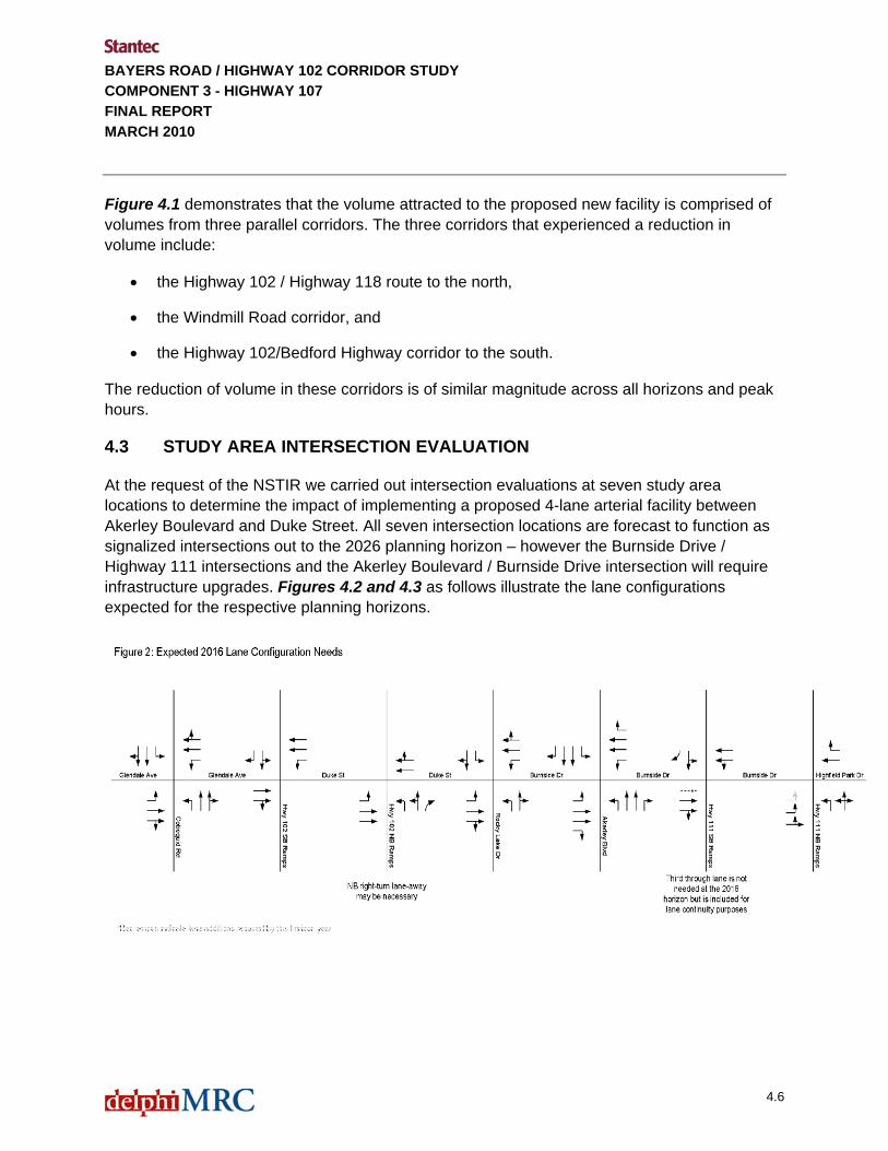
4.3 STUDY AREA INTERSECTION EVALUATION
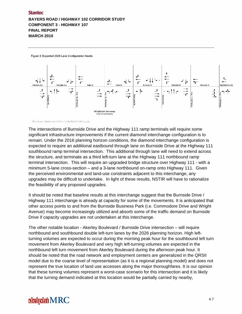
At the request of the NSTIR we carried out intersection evaluations at seven study area locations to determine the impact of implementing a proposed 4-lane arterial facility between Akerley Boulevard and Duke Street. All seven intersection locations are forecast to function as signalized intersections out to the 2026 planning horizon – however the Burnside Drive / Highway 111 intersections and the Akerley Boulevard / Burnside Drive intersection will require infrastructure upgrades. Figures 4.2 and 4.3 as follows illustrate the lane configurations expected for the respective planning horizons.
4.6
BAYERS ROAD / HIGHWAY 102 CORRIDOR STUDY COMPONENT 3 - HIGHWAY 107 FINAL REPORT MARCH 2010
The intersections of Burnside Drive and the Highway 111 ramp terminals will require some significant infrastructure improvements if the current diamond interchange configuration is to remain. Under the 2016 planning horizon conditions, the diamond interchange configuration is expected to require an additional eastbound through lane on Burnside Drive at the Highway 111 southbound ramp terminal intersection. This additional through lane will need to extend across the structure, and terminate as a third left-turn lane at the Highway 111 northbound ramp terminal intersection. This will require an upgraded bridge structure over Highway 111 - with a minimum 5-lane cross-section – and a 3-lane northbound on-ramp onto Highway 111. Given the perceived environmental and land-use constraints adjacent to this interchange, any upgrades may be difficult to undertake. In light of these results, NSTIR will have to rationalize the feasibility of any proposed upgrades.
It should be noted that baseline results at this interchange suggest that the Burnside Drive / Highway 111 interchange is already at capacity for some of the movements. It is anticipated that other access points to and from the Burnside Business Park (i.e. Commodore Drive and Wright Avenue) may become increasingly utilized and absorb some of the traffic demand on Burnside Drive if capacity upgrades are not undertaken at this interchange.
The other notable location - Akerley Boulevard / Burnside Drive intersection – will require northbound and southbound double left-turn lanes by the 2026 planning horizon. High left-turning volumes are expected to occur during the morning peak hour for the southbound left turn movement from Akerley Boulevard and very high left-turning volumes are expected in the northbound left turn movement from Akerley Boulevard during the afternoon peak hour. It should be noted that the road network and employment centers are generalized in the QRSII model due to the coarse level of representation (as it is a regional planning model) and does not represent the true location of land use accesses along the major thoroughfares. It is our opinion that these turning volumes represent a worst-case scenario for this intersection and it is likely that the turning demand indicated at this location would be partially carried by nearby,
4.7
BAYERS ROAD / HIGHWAY 102 CORRIDOR STUDY COMPONENT 3 - HIGHWAY 107 FINAL REPORT MARCH 2010
4.8
unmodeled streets and intersections. Therefore, we strongly recommend that the need for these additional turning lanes be monitored into the future.
4.4 A NOTE ON THE HIGHWAY 102 CORRIDOR
The findings from the travel demand modeling for the Highway 102 Corridor Study indicated that a 6-lane cross-section would be required on Highway 102 between Hammonds Plains Road and Highway 101 to accommodate the 2026 forecast volumes. This particular finding was based on the assumption that both Highway 113 and the Highway 107 extension facilities were in place (the Scenario B and C road networks).
If we review the findings of the analysis carried out for this supplementary work – using the Scenario A road network plus the Burnside Drive extension (and no Highway 113) – the Highway 102 can function with a 4-lane cross-section at the 2026 planning horizon between Hammond Plains Road and Highway 101. At this particular planning horizon, we expect the volume-to-capacity ratio to be about 0.84 in the peak direction, during the peak hour.
BAYERS ROAD / HIGHWAY 102 CORRIDOR STUDY COMPONENT 3 - HIGHWAY 107 FINAL REPORT MARCH 2010
5.1
5.0 Summary and Conclusions
5.1 PROPERTY IMPACTS AND PUBLIC INFORMATION SESSIONS
The functional plans in Appendix C show the approximate right-of-way required for the construction of Highway 107 and the resulting properties which will be impacted by construction. An estimated 60 properties and 35 different property owners along the Highway 107 Corridor would be directly impacted by the construction. The primary land owner is Municipal Dexter. This information along with HRM GIS data base information was used to notify these property owners of the public information sessions which were held as part of Component 2 of the project. The Public Information Sessions were held to explain the study and obtain information and feedback from local residents, businesses, and landowners. Chapter 8.0 of the Component 2 report describes the sessions.
The following sessions were held:
February Sessions • Wednesday, February 11, 2009 at the St. Andrew’s Centre, 6955 Bayer’s Road, Halifax,
from 6pm to 9pm with a presentation at 6:30pm • Thursday, February 12, 2009 at the LeBrun Community Centre, 36 Holland Avenue,
Bedford, from 6pm to 9pm with a presentation at 6:30pm. Following the February sessions, two additional sessions were conducted in response to requests for better coverage of the Sackville and Burnside areas.
March Sessions • Wednesday, March 25, 2009 at the Sackville High School, 1 Kingfisher Way,
Lower Sackville, from 6pm to 9pm with a presentation at 6:30pm • Thursday, March 26, 2009 at the Park Plaza Hotel and Conference Centre, Ramada
Plaza, 240 Brownlow Avenue, Dartmouth, from 4pm to 6pm. From the questionnaires and comments received, it may be inferred that the majority of those who provided comments regarding the highway 107 project agree with the project.
As a result of the public input received and subsequent discussions with the steering committee, some minor changes were considered appropriate. In addition, it was determined that careful consideration of the Highway 107 phase 1 is required. This phase would direct traffic directly to Glendale from the new Highway 107 and this has been identified as a primary concern.

BAYERS ROAD / HIGHWAY 102 CORRIDOR STUDY COMPONENT 3 - HIGHWAY 107 FINAL REPORT MARCH 2010
5.2
5.2 OPINION OF PROBABLE COST
5.2.1 Basis for the Costing
Based on the functional design, the team prepared an opinion of capital costs for the major components of construction. Costs are identified for each phase of the project, and identified in present day (2009) dollars. The opinion of capital cost expenditures have been projected based on the following:
• The team developed preliminary quantity estimates for major cost items such as granulars, pavement, structures, and earthworks for the infrastructure expansions in the corridor.
• Historical construction unit costs were used to develop “cost per unit” rates that were applied to major work categories such as kilometers of roadway and square meters of structure.
• Allowances for other major cost items such as intersection signals were included.
• The resulting costs were then increased by an applied percentage to account for miscellaneous items.
We understand that the costing may be used for planning and decision making and the basis of funding and approval processes. However, it must also be understood that, while we use information available to us combined with our judgment and past experience, the specific rationale and conditions forming the basis of contractors' bids, material or equipment pricing, are beyond our knowledge and control. An unknown source stated:
"An estimate is an attempt to project what someone else will be willing to contract for in the future to do construction work which has not yet been defined and which is subject to changes in scope, design, and market conditions".
In addition to scope, design and market conditions, scheduling, phasing, and many other factors will affect the cost of a project. Therefore, the costing in this report is no more than our "opinion" as to what the final costs may be. Provisional amounts, expressed as a percentage of the construction cost, are added to account for project items that cannot be accurately defined due to insufficient information. The value of the provisional amounts is subject to approval by NSTIR. However, the provisions should not be confused with the accuracy of the estimate. Provisions are expected to be spent. They are to allow for costs for items that will be encountered but are unknown or impossible to accurately estimate at this time. Provisional costs typically include:
• Engineering Costs
• Miscellaneous: Items such as landscaping, signage, culverts and other minor components of construction that have not been determined in the concept design.

BAYERS ROAD / HIGHWAY 102 CORRIDOR STUDY COMPONENT 3 - HIGHWAY 107 FINAL REPORT MARCH 2010
5.3
• Design Contingency: allowance for unknown factors and changes to the design as the project is better defined.
At this time, engineering costs and design contingencies have not been included in the reported costs. NSTIR is advised to allow for these items in their capital planning as appropriate.
5.2.2 Summary of Highway 107 Costs
Appendix D contains tables which show the unit costs that were used as well as the projected cost for each component of the corridor improvements. Table 5.1 is an overall summary of the approximate costs for the proposed Highway 107 Extension Table 5.1 – Highway 107 Cost Summary Table – by Phase
Item HIGHWAY 107 - SUMMARY No 1 - By Phase Approximate Cost 14.1 Phase 1 Highway 107 (Duke Street Extension) $47,000,00014.2 Phase 2 New Interchange on Highway 107 $0
14.3 Phase 3A - Highway 107 from Exit 4C to New Interchange (Westerly Connections) $28,000,000
14.4 Phase 3B - Highway 107 from Burnside Drive Interchange to Existing Hwy 107 $21,000,000
14.5 Phase 3C - Akerley Interchange $12,000,00012.3 Interchange: Highway 107 at Exit 4C (Option 1 Costing) $13,000,000
Total (excludes taxes, engineering, and contingencies) $121,000,000 Table 5.2 – Highway 107 Cost Summary Table – by Item
HIGHWAY 107 - SUMMARY No 2 - Major Items 1.0 Roadways - Gravels / Asphalt $42,000,0002.0 Mass Excavation $27,000,0003.0 Structures $36,000,0004.0 Miscellaneous Items (culverts, landscaping, paint, signage, etc.) $16,000,000
Total (excludes taxes, engineering, and contingencies) $121,000,000 The costs have been developed based on the limited information available as well as historical information. This is an order of magnitude estimate. The following items are key limitations in the costs:
• Accuracy of the mapping.
• Potential for design changes based on unknown factors.
• Schedule and phasing of the up-grades.
• Market conditions at the time of tendering.

BAYERS ROAD / HIGHWAY 102 CORRIDOR STUDY COMPONENT 3 - HIGHWAY 107 FINAL REPORT MARCH 2010
5.4
In addition the following has not been considered in the costing:
• Property acquisition costs
• Utility relocation costs
• Taxes
• Engineering Costs
• Design Contingencies
Stantec does not guarantee the accuracy of this opinion of probable cost. The actual final cost of the project will be determined through the bidding and construction process.
5.3 INFRASTRUCTURE IMPLEMENTATION SCHEDULE
5.3.1 Timeline for Expansions
Component 1 of this study provided the forecast number of mainline lanes required for the Highway 102 corridor. In Component 2, the study area ramps and intersections were analyzed for each of the 2016, 2026 and 2036 planning horizons. The Appendix C concept drawings are based on the full build-out of the facility to the 2036 horizon. Based on this information, a conceptual timeline for the expansions has been determined and shown in Table 5.3. This approximate timeline shows the roadway phases as noted in Table 5.1. In addition to comments provided in the table, the following is noted. An approximate 2 year time frame is assumed for each component of the work.
Table 5.3 Timelines
Horizon Year 2016 Horizon Year 2026 Horizon Year 2036
No. Location 20
10
2011
20
12
2013
20
14
2015
20
16
2017
20
18
2019
20
20
2021
20
22
2023
20
24
2025
20
26
2027
20
28
2029
20
30
2031
20
32
2033
20
34
2035
20
36
HIGHWAY 107
14.1 Phase 1 Highway 107 (Duke Street Extension)
14.2 Phase 2 New Interchange on Highway 107
14.3 Phase 3A - Highway 107 from Exit 4C to New Interchange -
14.4 Phase 3B - Highway 107 from B Drive Int to Exis Hwy 107
14.5 Phase 3C - Akerley Interchange
12.3 Interchange: 107 at Exit 4C

BAYERS ROAD / HIGHWAY 102 CORRIDOR STUDY COMPONENT 3 - HIGHWAY 107 FINAL REPORT MARCH 2010
5.3.2 Approximate Yearly Costs
Based on the approximate costs for each component of the project and the projected timeline, the following Figure 5.1 shows the resulting yearly costs.
Figure 5.1 Approximate Yearly Costs – Highway 107
$0
$5
$10
$15
$20
$25
Dol
lars
(Mill
ions
)
2010
2011
2012
2013
2014
2015
2016
2017
2018
2019
2020
2021
2022
2023
2024
2025
2026
2027
2028
2029
2030
2031
2032
2033
2034
2035
2036
Year
Approximate Yearly CostsHighway 107
5.4 BENEFIT / COST ASSESSMENT
A Benefit / Cost Assessment of the Highway 107 Extension was undertaken by Canmac Economics Limited. The full report is included in Appendix E. The assessment compares the Base Case (the status quo) and the preferred option as described in this report. The benefits associated with the new highway include:
• Travel time savings • Social cost savings
o Decreased accidents o Greenhouse gas emissions
The costs associated with the new highway include:
• Construction Costs • Operating and Maintenance Costs • Resurfacing Costs
5.5
BAYERS ROAD / HIGHWAY 102 CORRIDOR STUDY COMPONENT 3 - HIGHWAY 107 FINAL REPORT MARCH 2010
5.6
The analysis follows that outlined by Transport Canada (1994) and the methodology is consistent with the MicroBENCOST Software. A dollar value is assigned to the benefits in accordance with Transport Canada data. The benefits and costs were converted into net present value terms using an 8% discount rate and a project life to 2036. The analysis then looks at the sensitivity of the results to changes in the discount rate and project life. The resulting Benefit / Cost ratio varies from 1.8 to 2.4, concluding that the project makes a positive contribution to society.

APPENDIX A Terms of Reference


APPENDIX B Alignment Options
11/16/2009


Meeting Notes
b f:\jobs\20639\eng\03 - notes of meetings\meeting no. 7 march 7, 2008\minutes of meeting march 7, mtg no. 7.doc
Progress Meeting No. 7 of the Steering Committee Bayers Road / Highway 102 Corridor Study / FILE 20639 / 3
Date of Minutes: Tuesday, March 11, 2008
Date of Meeting: Friday, March 7, 2008
Place/Time: Stantec offices / 10 am to 1:30 pm
Next Meeting: TBD
Attendees: Name Group Contact Information Dwayne Cross NSTIR 424-2940, [email protected] Mike Croft NSTIR 424-3548, [email protected] Brian Ward NSTIR 424-5328, [email protected] Phil Corkum NSTIR 424-3508 Dave McCusker HRM 490-6696, [email protected] B.Landry Stantec 434-7331, bernadette.landry
@stantec.com P. Chouinard Stantec 434-7331, [email protected]
Absentees: Name Group Contact Information J. Copeland Delphi
Distribution: Attendees, absentees and others as required. B. Landry to distribute to consulting team. D. Cross to distribute to Steering Committee.
Item: Action:
1.0 Introduction
Purpose of this meeting: • To review and establish alternative alignments for Highway
107. 2.0 Highway 107 Alignments
Sketches as prepared by Stantec and submitted on Thursday February 28, 2008 were distributed and reviewed. Bernadette summarized the sketches and noted that they are meant for consideration along with other possible configurations. One of the main factors for consideration is the connection to Windmill Road. As previously advised by Delphi, the volumes through the dual roundabout will be a problem. The sketches showing the 100 series (pink) and the Arterial roads (green). The arterial network and future land development / access needs to be considered. and that this will influence the location and design of connection points These and possibly other scenarios should be tested in the model OPTION 1 – 107 CONNECTION TO EXIT 4C
Progress Meeting No. 7 of the Steering Committee Page 2 of 8
b f:\jobs\20639\eng\03 - notes of meetings\meeting no. 7 march 7, 2008\minutes of meeting march 7, mtg no. 7.doc
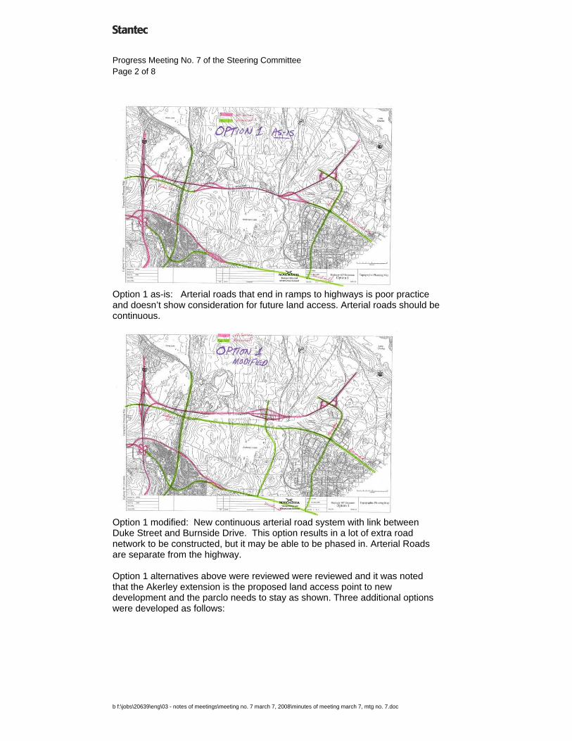
Option 1 as-is: Arterial roads that end in ramps to highways is poor practice and doesn’t show consideration for future land access. Arterial roads should be continuous.
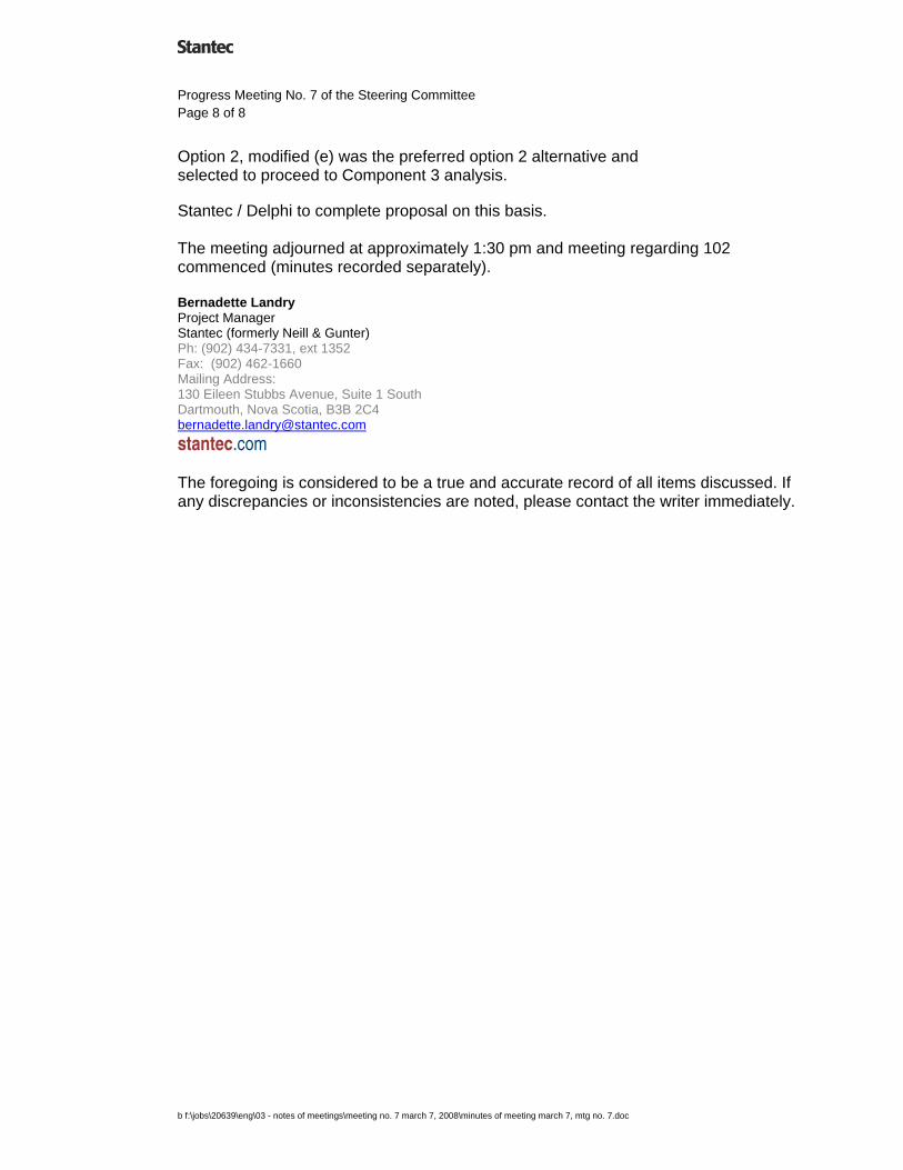
Option 1 modified: New continuous arterial road system with link between Duke Street and Burnside Drive. This option results in a lot of extra road network to be constructed, but it may be able to be phased in. Arterial Roads are separate from the highway. Option 1 alternatives above were reviewed were reviewed and it was noted that the Akerley extension is the proposed land access point to new development and the parclo needs to stay as shown. Three additional options were developed as follows:

Progress Meeting No. 7 of the Steering Committee Page 3 of 8
b f:\jobs\20639\eng\03 - notes of meetings\meeting no. 7 march 7, 2008\minutes of meeting march 7, mtg no. 7.doc
Option 1 modified (b) was suggested. Duke Street to Akerley would be continuous as arterial.
Option 1 modified (c) was suggested. The grade separation allows for future land access from Akerley.

Progress Meeting No. 7 of the Steering Committee Page 4 of 8
b f:\jobs\20639\eng\03 - notes of meetings\meeting no. 7 march 7, 2008\minutes of meeting march 7, mtg no. 7.doc
Option 1 modified (d) was selected as the preferred alternative to proceed. The grade separation allows for future land access from Akerley. An intersection (possibly a roundabout) allows for a future connection from Duke to Windmill. OPTION 2 – DIRECT CONNECTION TO 101 / 102 Some general comments made regarding the option 2 connections
- The common problem for option 2 alternatives is the complex connection at 101 / 102 / 107 as studied in the VE session.
- Traffic suggests that free-flow from Windmill to 107 is required. Stantec to confirm with Delphi if the optional connection was modeled in this analysis. If not, perhaps the optional connection would relieve the heavy left turns at the diamond interchange.
- Since the original option shows that Burnside would have directional ramps, does this mean that free-flow movement is also essential for this interchange? Stantec to confirm with Delphi.

Progress Meeting No. 7 of the Steering Committee Page 5 of 8
b f:\jobs\20639\eng\03 - notes of meetings\meeting no. 7 march 7, 2008\minutes of meeting march 7, mtg no. 7.doc
Option 2 as-is: Windmill road traffic through two roundabouts will be difficult to accommodate.
Option 2 modified (a) – this shows a trumpet configuration at Windmill as well as the “optional connection” moved to be a link between Duke and Burnside Drive. The objective is to provide a free-flow movement from Windmill to the 107.

Progress Meeting No. 7 of the Steering Committee Page 6 of 8
b f:\jobs\20639\eng\03 - notes of meetings\meeting no. 7 march 7, 2008\minutes of meeting march 7, mtg no. 7.doc
Option 2 modified (b) – this shows a new option with another arterial road network. A lot of road construction would be required to provide key connections.
Option 2 Modified C - developed at the meeting. Provides freeflow from Windmill to 107. Makes use of existing Bedford Bypass infrastructure. Duke Street would connect with Burnside Drive.

Progress Meeting No. 7 of the Steering Committee Page 7 of 8
b f:\jobs\20639\eng\03 - notes of meetings\meeting no. 7 march 7, 2008\minutes of meeting march 7, mtg no. 7.doc
Option 2 Modified (d) - developed at the meeting. Provides freeflow from Windmill to 107. Does not make use of existing Bedford Bypass infrastructure which is a significant drawback.
Option 2 Modified (e) - developed at the meeting. This alternative was selected as the preferred alternative at the meeting. Provides freeflow from Windmill to 107, but through roundabout interchange. Stantec to confirm with Delphi how this would be modeled. Makes use of existing Bedford Bypass infrastructure. Initial construction could be limited to 100 series roadway as well as link between Duke Street extension and the roundabout interchange. 3.0 Summary
Option 1, modified (d) was selected as preferred to proceed for the Component 3 analysis
Progress Meeting No. 7 of the Steering Committee Page 8 of 8
b f:\jobs\20639\eng\03 - notes of meetings\meeting no. 7 march 7, 2008\minutes of meeting march 7, mtg no. 7.doc
Option 2, modified (e) was the preferred option 2 alternative and selected to proceed to Component 3 analysis. Stantec / Delphi to complete proposal on this basis. The meeting adjourned at approximately 1:30 pm and meeting regarding 102 commenced (minutes recorded separately). Bernadette Landry Project Manager Stantec (formerly Neill & Gunter) Ph: (902) 434-7331, ext 1352 Fax: (902) 462-1660 Mailing Address: 130 Eileen Stubbs Avenue, Suite 1 South Dartmouth, Nova Scotia, B3B 2C4 [email protected]
stantec.com
The foregoing is considered to be a true and accurate record of all items discussed. If any discrepancies or inconsistencies are noted, please contact the writer immediately.
APPENDIX C Functional Plans


APPENDIX D Costing

14.1 Phase 1 Highway 107 (Duke Street Extension)Approx Average
Item Length Width Unit Approximate Approximate Approximate Sub-totalsNo. Item / Description Code Work Planned m m Quantity Unit Cost ($) Total Cost
Side STA STA Description14.1.1 Duke St from 4C Ramp to Rocky Lake Road Lt+Rt 9050 10300 1 Pavement Widening 1250 8 m2 10,000 $90 $900,000
- assume existing 3 lane section is widened to 5 lanes Lt+Rt 9050 10300 5 curb and gutter 2500 N/A m 2,500 $75 $187,500 - asume new urban section with storm sewer and sidewalks Lt+Rt 9050 10300 6 1.8 m Concrete Sidewalk 2500 N/A m 2,500 $150 $375,000
Lt+Rt 9050 10300 9 Storm Sewer with MH's, CB's - local drainage1250 N/A m 1,250 $430 $537,500Lt+Rt 9050 10300 4 Excavation - Unclassified - New Construction N/A m3 20,000 $14 $280,000 $2,280,000
14.1.2 Highway 107 from Rocky Lake Road to Burnside Drive N/A 10300 15334 29 4-lane freeway with narrow median 5034 N/A m 5,034 $2,800 $14,095,200Highway 107 from Rocky Lake Road to Burnside Drive N/A 10300 15334 4 Excavation - Unclassified - New Construction 5034 N/A m3 920,000 $14 $12,880,000 $26,975,200
14.1.2 Intersections Roundabout at New Road and Rocky Lake Road N/A N/A N/A 51 Roundabout 1 N/A each 1 $100,000 $100,000Changes to Akerley / Burnside Intersection and new signals N/A N/A N/A 50 Intersection Signals 1 N/A each 1 $150,000 $150,000 $250,000
14.1.3 Structures Over UnderCNR Crossing No. 1 - just east of Rocky Lake Road N/A N/A N/A 40 Structure 30.4 40 m2 1,216 $3,500 $4,256,000CNR Crossing No. 2 - station 13+600 (Trail or CN??) N/A N/A N/A 40 Structure 37.9 50 m2 1,895 $3,500 $6,632,500 $10,888,500
14.1.4 Trail N/A 10300 15334 15 3.0 m Wide Trail 5034 3 m2 15,102 $40 $604,080 $604,080
Sub-Total $40,997,780 $40,997,780Engineering Costs 70 Allowance for Engineering 0% $0
Miscellaneous 71 Miscellaneous Items (culverts, landscaping, paint, signage, etc.) 15% $6,149,667Contingency 72 Design Contingency 0% $0
TOTAL $47,147,447ROUNDED $47,000,000
14.1 Phase 1 Highway 107 (Duke Street Extension) Summary 6.3 km1.0 Roadways - Gravels / Asphalt / etc. $16,949,2802.0 Mass Excavation $13,160,0003.0 Structures $10,888,500
Sub-Total $40,997,780Provisional 15% $6,149,667
$47,147,447
14.2 Phase 2 New Interchange on Highway 107Approx Average
Item Length Width Unit Approximate Approximate Approximate Sub-totalsNo. Item / Description Code Work Planned m m Quantity Unit Cost ($) Total Cost
Side STA STA Description14.2.1 New Arterial (to daylighting triangles only)
New Arterial Raodway - 4 lane Full 400 1200 28 4 Lane arterial roadway 800 N/A m 800 $2,300 $1,840,000Roundabout 1 at Ramp Terminals N/A N/A N/A 51 Roundabout 1 N/A each 1 $100,000 $100,000Roundabout 2 at Ramp Terminals N/A N/A N/A 51 Roundabout 1 N/A each 1 $100,000 $100,000New Arterial and Roundabouts Full 400 1200 4 Excavation - Unclassified - New Construction 800 N/A m3 15000 $14 $210,000 $2,250,000
14.2.2 Structures Over UnderNew Interchange Structure N/A N/A N/A 40 Structure 24.8 51.8 m2 1284.64 $3,500 $4,496,240 $4,496,240
14.2.3. RampsRamp 1 - New Arterial to Duke Street 1 - lane 90000 90450 33 Roundabout to BN 450 N/A m 450 $1,200 $540,000Ramp 1 - New Arterial to Duke Street 2 - lane 90450 90900 34 BN to BN 450 N/A m 450 $1,400 $630,000Ramp 2 - Duke Street to New Arterial 1 - lane 70250 70900 33 BN to BN 650 N/A m 650 $1,200 $780,000Ramp 2 - Duke Street to New Arterial 2 - lane 70900 71286 34 BN to Roundabout 386 N/A m 386 $1,400 $540,400Ramp 3 - includes aux lanes 1 - lane 30000 30800 33 to Roundabout 800 N/A m 800 $1,200 $960,000Ramp 4 - includes aux lanes 1 - lane 10000 11000 33 to taper 1000 N/A m 1000 $1,200 $1,200,000Interchange Ramps - Mass Excavation (also includes ramps 5, 6 and 7 from phase 3) 4 Excavation - Unclassified - New Construction 0 N/A m3 907000 $14 $12,698,000 $17,348,400
Sub-Total $24,094,640 $24,094,640Engineering Costs 70 Allowance for Engineering 0% $0
Miscellaneous 71 Miscellaneous Items (culverts, landscaping, paint, signage, etc.) 15% $3,614,196Contingency 72 Design Contingency 0% $0
TOTAL $27,708,836ROUNDED $28,000,000
14.2 Phase 2 New Interchange on Highway 107 Summary 4.5 Km1.0 Roadways - Gravels / Asphalt $6,690,4002.0 Mass Excavation $12,908,0003.0 Structures $4,496,240
Sub-Total $24,094,640Provisional 15% $3,614,196
$27,708,836

14.3 Phase 3A - Highway 107 from Exit 4C to New Interchange - Westerly ConnectionsApprox Average
Item Length Width Unit Approximate Approximate Approximate Sub-totalsNo. Item / Description Code Work Planned m m Quantity Unit Cost ($) Total Cost
Side STA STA Description14.3.1 Highway 107 from 4C to New Interchange N/A 100200 101100 29 4-lane freeway with narrow median 900 N/A m 900 $2,800 $2,520,000
Highway 107 from 4C to New Interchange N/A 101100 101500 29.6 6-lane freeway with narrow median 400 N/A m 400 $3,300 $1,320,000Highway 107 from 4C to New Interchange N/A 101500 102000 29 4-lane freeway with narrow median 500 N/A m 500 $2,800 $1,400,000Highway 107 from 4C to New Interchange N/A 100200 102000 4 Excavation - Unclassified - New Construction 1800 N/A m3 250000 $14 $3,500,000 $8,740,000
14.3.2 Structures Over UnderHighway 107 over Existing Roadway N/A N/A N/A 40 Structure 26.8 19 m2 509.2 $3,500 $1,782,200Highway 107 over Mann Street N/A N/A N/A 40 Structure 26.8 19 m2 509.2 $3,500 $1,782,200Highway 107 over Rocky Lake Rd and CNR N/A N/A N/A 40 Structure 26.8 60 m2 1608 $3,500 $5,628,000Highway 107 over Ramp 1 N/A N/A N/A 40 Structure 34.2 17.5 m2 598.5 $3,500 $2,094,750Ramp 5 over Ramp 6 N/A N/A N/A 40 Structure 15 15 m2 225 $3,500 $787,500Ramp 7 over Phase 1 road N/A N/A N/A 40 Structure 15 30.4 m2 456 $3,500 $1,596,000 $13,670,650
14.3.3 RampsRamp 5 - New Arterial to 107W 1 - lane 50200 50650 33 450 N/A m 450 $1,200 $540,000Ramp 6 - 107W to Duke Street 1 - lane 40400 40850 33 450 N/A m 450 $1,200 $540,000Ramp 7 - Duke Street to New Arterial 1 - lane 60400 60800 33 400 N/A m 400 $1,200 $480,000 $1,560,000Excavation - included in phase 2 ramps or the mianline construction (item 14.3.1)
Sub-Total $23,970,650 $23,970,650Engineering Costs 70 Allowance for Engineering 0% $0
Miscellaneous 71 Miscellaneous Items (culverts, landscaping, paint, signage, etc.) 15% $3,595,598Contingency 72 Design Contingency 0% $0
TOTAL $27,566,248ROUNDED $28,000,000
14.3 Phase 3A - Highway 107 from Exit 4C to New Interchange - Westerly ConnectionsSummary 3.1 Km1.0 Roadways - Gravels / Asphalt $6,800,0002.0 Mass Excavation $3,500,0003.0 Structures $13,670,650
Sub-Total $23,970,650Provisional 15% $3,595,598
$27,566,248
14.4 Phase 3B - Highway 107 from B Drive Int to Exis Hwy 107Approx Average
Item Length Width Unit Approximate Approximate Approximate Sub-totalsNo. Item / Description Code Work Planned m m Quantity Unit Cost ($) Total Cost
Side STA STA Description14.4.1 Highway 107 from CNR Crossing No 2 to Existing 107 N/A 104200 105200 29 4-lane freeway with narrow median 1000 N/A m 1000 $2,800 $2,800,000
Highway 107 from CNR Crossing No 2 to Existing 107 N/A 105200 105850 29.3 5-lane freeway with narrow median 650 N/A m 650 $3,000 $1,950,000Highway 107 from CNR Crossing No 2 to Existing 107 N/A 105850 106600 29.6 6-lane freeway with narrow median 750 N/A m 750 $3,300 $2,475,000Highway 107 from CNR Crossing No 2 to Existing 107 N/A 104200 106600 4 Excavation - Unclassified - New Construction 2400 N/A m3 450000 $14 $6,300,000 $13,525,000
14.4.2 Structures Over UnderHighway 107 over Burnside Drive Interchange Ramp N/A N/A N/A 40 Structure 26.8 17.5 m2 469 $3,500 $1,641,500 $1,641,500
14.4.3 RampsRamp 8 - Burnside Drive to 107W 2 - lane 20800 21900 34 1100 N/A m 1100 $1,400 $1,540,000Ramp 8 - Burnside Drive to 107W - Excavation is allowance only 4 Excavation - Unclassified - New Construction m3 90000 $14 $1,260,000 $2,800,000
Sub-Total $17,966,500 $17,966,500Engineering Costs 70 Allowance for Engineering 0% $0
Miscellaneous 71 Miscellaneous Items (culverts, landscaping, paint, signage, etc.) 15% $2,694,975Contingency 72 Design Contingency 0% $0
TOTAL $20,661,475ROUNDED $21,000,000
14.4 Phase 3B - Highway 107 from B Drive Int to Exis Hwy 107 3.5 km1.0 Roadways - Gravels / Asphalt $8,765,0002.0 Mass Excavation $7,560,0003.0 Structures $1,641,500
Sub-Total $17,966,500Provisional 15% $2,694,975
$20,661,475

14.5 Phase 3C - Akerley InterchangeApprox Average
Item Length Width Unit Approximate Approximate Approximate Sub-totalsNo. Item / Description Code Work Planned m m Quantity Unit Cost ($) Total Cost
Side STA STA Description14.5.1 New Arterial
New Arterial Roadway - 4 lane Full 2000 2800 28 4 Lane arterial roadway 800 N/A m 800 $2,300 $1,840,000Roundabout 1 at Ramp Terminals N/A N/A N/A 51 Roundabout 1 N/A each 1 $100,000 $100,000Roundabout 2 at Ramp Terminals N/A N/A N/A 51 Roundabout 1 N/A each 1 $100,000 $100,000New Arterial Roadway - 4 lane N/A 2000 2800 4 Excavation - Unclassified - New Construction 800 N/A m3 100000 $14 $1,400,000 $3,440,000
14.5.2 Structures Over UnderAkerley over Highway 107 N/A N/A N/A 40 Structure 24.8 51.8 m2 1284.64 $3,500 $4,496,240 $4,496,240
14.5.3 RampsRamp 1 1 - lane 0 300 33 400 N/A m 400 $1,200 $480,000Ramp 2 1 - lane 0 300 33 400 N/A m 400 $1,200 $480,000Ramp 3 1 - lane 0 300 33 400 N/A m 400 $1,200 $480,000Ramp 4 1 - lane 0 300 33 400 N/A m 400 $1,200 $480,000Interchange Ramps - Mass Excavation - Allowance assumed 4 Excavation - Unclassified - New Construction m3 35000 $14 $490,000 $2,410,000 some grading already done for this interchange
Sub-Total $10,346,240 $10,346,240Engineering Costs 70 Allowance for Engineering 0% $0
Miscellaneous 71 Miscellaneous Items (culverts, landscaping, paint, signage, etc.) 15% $1,551,936Contingency 72 Design Contingency 0% $0
TOTAL $11,898,176ROUNDED $12,000,000
Phase 3C - Akerley Interchange 2.4 km1.0 Roadways - Gravels / Asphalt $3,960,0002.0 Mass Excavation $1,890,0003.0 Structures $4,496,240
Sub-Total $10,346,240Provisional 15% $1,551,936
$11,898,176
HIGHWAY 107 - SUMMARY No 1 - Cost per phase (excluding provisional costs) Rounded14.1 Phase 1 Highway 107 (Duke Street Extension) $40,997,780 $41,000,00014.2 Phase 2 New Interchange on Highway 107 $0 $014.3 Phase 3A - Highway 107 from Exit 4C to New Interchange - Westerly Connections $23,970,650 $24,000,00014.4 Phase 3B - Highway 107 from B Drive Int to Exis Hwy 107 $17,966,500 $18,000,00014.5 Phase 3C - Akerley Interchange $10,346,240 $10,000,00012.3 Interchange: Highway 107 at Exit 4C (Option 1 Costing) $12,020,000 $12,000,000
Sub-Total $105,301,170 $105,000,000Engineering Costs, Misc and Contingency 15% $15,795,176 $16,000,000
$121,096,346 $121,000,000** Full build-out to phase 3, but excluding phase 2 (the interchange)
HIGHWAY 107 - SUMMARY No 2 - Cost per phase with provisional costs in each phase14.1 Phase 1 Highway 107 (Duke Street Extension) $47,000,00014.2 Phase 2 New Interchange on Highway 107 $014.3 Phase 3A - Highway 107 from Exit 4C to New Interchange - Westerly Connections $28,000,00014.4 Phase 3B - Highway 107 from B Drive Int to Exis Hwy 107 $21,000,00014.5 Phase 3C - Akerley Interchange $12,000,00012.3 Interchange: Highway 107 at Exit 4C (Option 1 Costing) $14,000,000
Sub-Total $122,000,000
** Full build-out to phase 3, but excluding phase 2 (the interchange)
HIGHWAY 107 - SUMMARY No 3 - Major Items ** Rounded1.0 Roadways - Gravels / Asphalt $41,950,580 $42,000,0002.0 Mass Excavation $27,147,500 $27,000,0003.0 Structures $36,203,090 $36,000,0004.0 Miscellaneous Items (culverts, landscaping, paint, signage, etc.) $15,795,176 $16,000,000
Sub-Total $121,096,346 $121,000,000
** Full build-out to phase 3, but excluding phase 2 (the interchange)

MASTER LIST USED IN COST TABLES
Item Cost UnitCode WIDENING / EXCAVATION / ASSOCIATED ROADWAY WORK
1 Pavement Widening $90.00 m22 Highway Shoulder Construction - Wide shoulder with guard rail $500.00 m3 Excavation -Unclassified - for re-construction $25.00 m34 Excavation -Unclassified - for new construction $14.00 m35 Curb and Gutter $75.00 m6 1.8 m Concrete Sidewalk $150.00 m7 Storm Leads and CB's $60.00 m8 Raised narrow median $200.00 m9 Storm Sewer with MH's, CB's - local drainage $430.00 m
10 Crown Shift and New Jersey Barrier $500.00 m11 Retaining Wall - 1-3 m in height $1,500.00 m12 Retaining Wall - 3-7 m in height $5,000.00 m15 Trail with 300mm gravel and 50mm asphalt $40.00 m2
NEW ROADWAYS (including excavation for roadbase)19 local road - 9 m width $2,300.00 m20 4 Lane arterial roadway $2,600.00 m21 5 lane arterial roadway $2,900.00 m22 6 lane arterial roadway $3,300.00 m23 4-lane freeway with narrow median $3,100.00 m24 5-lane freeway with narrow median $3,500.00 m25 6-lane freeway with narrow median $3,800.00 m26 7-lane freeway with narrow median $4,100.00 m27 8-lane freeway with narrow median $4,500.00 m
NEW ROADWAYS (excluding excavation for roadbase)28 4 Lane arterial roadway $2,300.00 m29 4-lane freeway with narrow median $2,800.00 m
29.3 5-lane freeway with narrow median $3,000.00 m29.6 6-lane freeway with narrow median $3,300.00 m
NEW RAMPS (including excavation for roadbase)30 Single Lane Ramp $1,300.00 m31 Two lane Ramp $1,500.00 m32 Three Lane Ramp $1,800.00 m
NEW RAMPS (excluding excavation for roadbase)33 Single Lane Ramp $1,200.00 m34 Two lane Ramp $1,400.00 m35 Three Lane Ramp $1,600.00 m
STRUCTURES40 New Bridge Structure $3,500.00 m241 Expand Existing Bridge Structure $5,000.00 m2
INTERSECTIONS50 Intersection Signals $150,000.00 each51 Roundabout $100,000.00 each
DEMOLITION61 Bridge Demolition $1,000.00 m262 Ramp / Road decommissioning $200.00 m
PROVISIONAL AMOUNTS70 Allowance for Engineering 0%71 Miscellaneous Items (Landscaping, paint, signage, etc.) 15%72 Design Contingency 0%
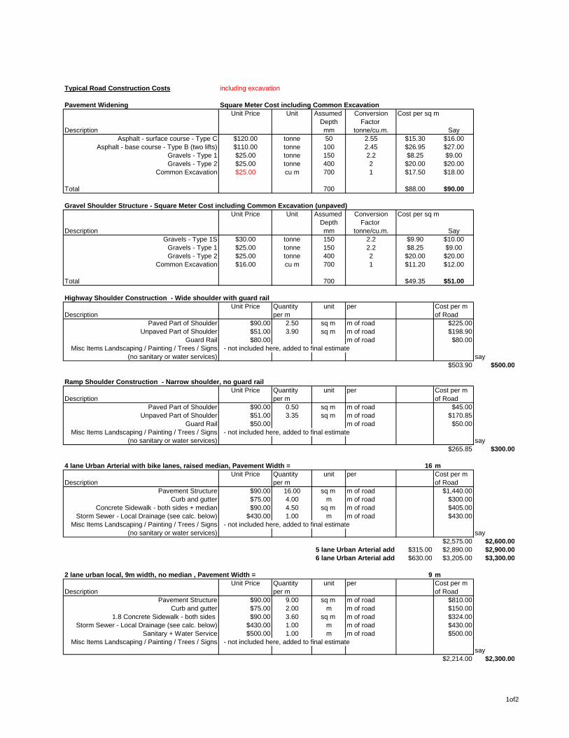
Typical Road Construction Costs including excavation
Pavement Widening Square Meter Cost including Common ExcavationUnit Price Unit Assumed Conversion Cost per sq m
Depth Factor Description mm tonne/cu.m. Say
Asphalt - surface course - Type C $120.00 tonne 50 2.55 $15.30 $16.00Asphalt - base course - Type B (two lifts) $110.00 tonne 100 2.45 $26.95 $27.00
Gravels - Type 1 $25.00 tonne 150 2.2 $8.25 $9.00Gravels - Type 2 $25.00 tonne 400 2 $20.00 $20.00
Common Excavation $25.00 cu m 700 1 $17.50 $18.00
Total 700 $88.00 $90.00
Gravel Shoulder Structure - Square Meter Cost including Common Excavation (unpaved)Unit Price Unit Assumed Conversion Cost per sq m
Depth Factor Description mm tonne/cu.m. Say
Gravels - Type 1S $30.00 tonne 150 2.2 $9.90 $10.00Gravels - Type 1 $25.00 tonne 150 2.2 $8.25 $9.00Gravels - Type 2 $25.00 tonne 400 2 $20.00 $20.00
Common Excavation $16.00 cu m 700 1 $11.20 $12.00
Total 700 $49.35 $51.00
Highway Shoulder Construction - Wide shoulder with guard railUnit Price Quantity unit per Cost per m
Description per m of RoadPaved Part of Shoulder $90.00 2.50 sq m m of road $225.00
Unpaved Part of Shoulder $51.00 3.90 sq m m of road $198.90Guard Rail $80.00 m of road $80.00
Misc Items Landscaping / Painting / Trees / Signs - not included here, added to final estimate(no sanitary or water services) say
$503.90 $500.00
Ramp Shoulder Construction - Narrow shoulder, no guard railUnit Price Quantity unit per Cost per m
Description per m of RoadPaved Part of Shoulder $90.00 0.50 sq m m of road $45.00
Unpaved Part of Shoulder $51.00 3.35 sq m m of road $170.85Guard Rail $50.00 m of road $50.00
Misc Items Landscaping / Painting / Trees / Signs - not included here, added to final estimate(no sanitary or water services) say
$265.85 $300.00
4 lane Urban Arterial with bike lanes, raised median, Pavement Width = 16 mUnit Price Quantity unit per Cost per m
Description per m of RoadPavement Structure $90.00 16.00 sq m m of road $1,440.00
Curb and gutter $75.00 4.00 m m of road $300.00Concrete Sidewalk - both sides + median $90.00 4.50 sq m m of road $405.00
Storm Sewer - Local Drainage (see calc. below) $430.00 1.00 m m of road $430.00Misc Items Landscaping / Painting / Trees / Signs - not included here, added to final estimate
(no sanitary or water services) say$2,575.00 $2,600.00
5 lane Urban Arterial add $315.00 $2,890.00 $2,900.006 lane Urban Arterial add $630.00 $3,205.00 $3,300.00
2 lane urban local, 9m width, no median , Pavement Width = 9 mUnit Price Quantity unit per Cost per m
Description per m of RoadPavement Structure $90.00 9.00 sq m m of road $810.00
Curb and gutter $75.00 2.00 m m of road $150.001.8 Concrete Sidewalk - both sides $90.00 3.60 sq m m of road $324.00
Storm Sewer - Local Drainage (see calc. below) $430.00 1.00 m m of road $430.00Sanitary + Water Service $500.00 1.00 m m of road $500.00
Misc Items Landscaping / Painting / Trees / Signs - not included here, added to final estimatesay
$2,214.00 $2,300.00
1of2

4 lane rural section Highway with 5.6m Narrow Median with Jersey Barrier, Pavement Width = 20.4 mUnit Price Quantity unit per Cost per m
Description per m of RoadPavement Structure $90.00 20.40 sq m m of road $1,836.00
Wide Shoulder with guard rail $500.00 2.00 m m of road $1,000.00Storm Sewer ** $60.00 1.00 m m of road $60.00
Jersey Barrier $200.00 1.00 m m of road $200.00Misc Items Landscaping / Painting / Trees / Signs - not included here, added to final estimate
(no sanitary or water services) say**CB's and leads would be required for superelevated sections $3,096.00 $3,100.00
5 lane Highway add $333.00 $3,429.00 $3,500.006 lane Highway add $666.00 $3,762.00 $3,800.007 lane Highway add $999.00 $4,095.00 $4,100.008 lane Highway add $1,332.00 $4,428.00 $4,500.00
Single Lane Ramp - Rural Section, Pavement Width = 5 mUnit Price Quantity unit per Cost per m
6 lane rural section Highway with narrow median, jersey barrier per m of Roadpavement structure $90.00 5.00 sq m m of road $450.00
Wide Shoulder (right) with guard rail $500.00 1.00 m m of road $500.00Narrow Shoulder (left), no guard rail $300.00 1.00 m m of road $300.00
Misc Items Landscaping / Painting / Trees / Signs - not included here, added to final estimate(no storm, sanitary or water services) say
$1,250.00 $1,300.002 lane Ramp add $216.00 $1,466.00 $1,500.003 lane Ramp add $549.00 $1,799.00 $1,800.00
Storm Sewer Typical CostUnit Price Quantity unit per Cost per m
per m of RoadStorm Sewer - Local Drainage $300.00 1.00 m m of road $300.00
MH's $3,000.00 1.00 each 100 m of road $30.00CB's $2,500.00 2.00 each 50 m of road $100.00
$430.00Storm Sewer - New CB's and Leads Only for widening $3,000.00 1.00 each 50 m of road $60.00
2of2