Baxi Heating UK Site, Padiham 0042...Baxi Heating UK Site, Padiham EXTENDED PHASE 1 HABITAT SURVEY...
48
Baxi Heating UK Site, Padiham EXTENDED PHASE 1 HABITAT SURVEY REPORT Issue 3 September 2013
Transcript of Baxi Heating UK Site, Padiham 0042...Baxi Heating UK Site, Padiham EXTENDED PHASE 1 HABITAT SURVEY...

Baxi Heating UK Site, Padiham
EXTENDED PHASE 1 HABITAT SURVEY REPORT
Issue 3
September 2013

The SKM logo trade mark is a registered trade mark of Sinclair Knight Merz Pty Ltd.
Baxi Heating UK Site, Padiham
EXTENDED PHASE 1 HABITAT SURVEY REPORT
Issue 3
September 2013
SKM Enviros Newminster House 27-29 Baldwin Street Bristol BS1 1LT Tel: +44 (0)117 917 0800 Web: www.skmenviros.com
COPYRIGHT: The concepts and information contained in this document are the property of Sinclair Knight Merz (Europe) Ltd. Use or copying of this document in whole or in part without the written permission of Sinclair Knight Merz (Europe) Ltd constitutes an infringement of copyright.
LIMITATION: This report has been prepared on behalf of and for the exclusive use of Sinclair Knight Merz (Europe) Ltd’s Client, and is subject to and issued in connection with the provisions of the agreement between Sinclair Knight Merz (Europe) Ltd and its Client. Sinclair Knight Merz (Europe) Ltd accepts no liability or responsibility whatsoever for or in respect of any use of or reliance upon this report by any third party.

Extended Phase 1 Habitat Survey Report
SKM Enviros
K:\United Kingdom\Salford\VNIF\Projects\VN50248\Deliverables\Reports\Ecology\Phase 1 Habitat Survey\Issue 3\Baxi Padiham_Extended Phase 1
Habitat Survey Report_Issue_3_231013.docx PAGE 1
Contents
1. Introduction 3
1.1. Introduction 3
1.2. Project Background 3
1.3. Site Description 3
1.4. Objectives 3
2. Methodology 4
2.1. Desk Study 4
2.2. Extended Phase 1 Habitat Survey 5
3. Results 7
3.1. Desk Study 7
3.2. Extended Phase 1 Habitat Survey 12
3.3. Fauna 14
4. Potential Constraints and Recommendations for Further Surveys 20
4.1. Designated Sites 20
4.2. Habitats 20
4.3. Invasives 20
4.4. Amphibians 20
4.5. Reptiles 22
4.6. Otter and Water Vole 23
4.7. Badger 24
4.8. Bats 24
4.9. Birds 25
5. Opportunities for Biodiversity Enhancement 26
Figures
Figure 1: Site Plan
Figure 2: Phase 1 habitat map
Appendix 1 – Target Notes
Appendix 2 – Plates
Appendix 3 – HSI Results

SKM Enviros
K:\United Kingdom\Salford\VNIF\Projects\VN50248\Deliverables\Reports\Ecology\Phase 1 Habitat Survey\Issue 3\Baxi Padiham_Extended Phase 1
Habitat Survey Report_Issue_3_231013.docx PAGE 2
Document history and status
Revision Date issued Reviewed by Approved by Date approved Revision type
Draft 1 PC PC 04.06.13 First Issue
V2 30.09.13 SF Second Issue
V3 23.10.13 SF Third Issue
Distribution of copies
Revision Copy no Quantity Issued to
V1 1 1 Client
V2 1 1 Client
V3 1 1 Client
Printed: 23 October 2013
Last saved: 23 October 2013 03:42 PM
File name:
K:\United Kingdom\Salford\VNIF\Projects\VN50248\Deliverables\Reports\Ecology\Phase 1 Habitat Survey\Issue 3\Baxi Padiham_Extended Phase 1 Habitat Survey Report_Issue_3_231013.docx
Author: S Fraser
Project manager: Nigel Robson
Name of organisation: Baxi Heating UK
Name of project: Baxi Padiham Site Redevelopment
Name of document: Extended Phase 1 Survey Habitat Report
Document version: Issue 2
Project number: VN50248

SKM Enviros
K:\United Kingdom\Salford\VNIF\Projects\VN50248\Deliverables\Reports\Ecology\Phase 1 Habitat Survey\Issue 3\Baxi Padiham_Extended Phase 1
Habitat Survey Report_Issue_3_231013.docx PAGE 3
1. Introduction
1.1. Introduction
SKM Enviros was commissioned in May 2013 by Baxi Heating Limited (BHL) to carry out an
extended Phase 1 habitat survey of land at Wyre Street, Padiham, Burnley, Lancashire
(approximate centre of the site located at SD800341).
1.2. Project Background
This work has been commissioned to support an outline planning application for approximately
300 residential units on land owned by Baxi.
1.3. Site Description
The site is situated approximately 0.4 kilometres (km) to the east of Padiham town centre, which
lies some 4km to the northwest of Burnley in Lancashire. The site is located in a semi-rural area.
To the north and east of the site lies predominantly agricultural land; residential, commercial and
industrial development are present to the south and west. The River Calder runs along the southern
boundary of the site.
The site is currently underused by BHL and extends to approximately 16 hectares (ha). The
existing BHL site is divided broadly in to four areas (see Figure 1):
1. Land occupied by the main BHL factory (approximately 6.9ha);
2. Land occupied by Rapid IT Parts (approximately 0.2ha) and Craggs Energy Oil Depot
(approximately 0.5ha);
3. Open space located to the north of the factory (1.2ha); and
4. Agricultural land located to the east of the factory (7ha).
The current proposals for the site involve the development of areas 1-3 for housing and the
retention of area 4 as grassland..
1.4. Objectives
The objective of the survey was to establish the baseline ecological conditions on site and within
the immediate vicinity, including its potential to support important habitats and notable/protected
species and to highlight potential ecological constraints to the proposed development.

SKM Enviros
K:\United Kingdom\Salford\VNIF\Projects\VN50248\Deliverables\Reports\Ecology\Phase 1 Habitat Survey\Issue 3\Baxi Padiham_Extended Phase 1
Habitat Survey Report_Issue_3_231013.docx PAGE 4
2. Methodology
2.1. Desk Study
A baseline biodiversity search was obtained from the Lancashire Environmental Records Network
(LERN) for the site plus a radius of 2km from the centre of the site. The search data included:
Biological Heritage Sites (BHS) - The principal non-statutory local wildlife sites in
Lancashire.
Lancashire BAP Long List species records*
District-level local wildlife sites where present (boundary and summary site details only).
* Those species which occur in Lancashire and are of significance according to the criteria listed
below:
1. UK Priority:
Species which are identified as a UK BAP Priority Species (in the 2007 review) and occur in
Lancashire .
Species which are identified for inclusion in the IUCN threatened groups (critically
endangered, endangered, vulnerable, near threatened) and occur in Lancashire .
2. Lancashire BAP species:
Species which were identified in the 2001 Lancs BAP, and in later additions, for which SAP's
already exist.
3. Nationally scarce species:
Species recorded from Lancashire which are known or estimated to occur in fewer than 100
hectads nationally
4. Local decline
A declining equal to or greater than 25 % in species numbers or range in BAP area over
previous 25 years.
5. Local rarity or scarcity
Species currently occurring in equal to or less than 35 (4.0%) tetrads in the BAP area.
Species currently occurring in equal to or less than 6 (0.6%) tetrads in the BAP area ( Birds
only )
6. Local extinction:
Species recorded from Lancashire in the past 50 years but not found recently.

SKM Enviros
K:\United Kingdom\Salford\VNIF\Projects\VN50248\Deliverables\Reports\Ecology\Phase 1 Habitat Survey\Issue 3\Baxi Padiham_Extended Phase 1
Habitat Survey Report_Issue_3_231013.docx PAGE 5
7. International importance:
Species deemed to have internationally important numbers in the BAP area.
In addition to data obtained from LERN, Peter Hornby, a local naturalist who regularly visits Area
4 to survey for wintering snipe, was conducted for general records of the site
A search was also carried out via the Multi-Agency Geographical Information for the Countryside
(MAGIC) website1 for statutory sites of nature conservation within a 2km radius of the site.
2.2. Extended Phase 1 Habitat Survey
2.2.1. Habitats / Vegetation
An extended Phase 1 habitat survey was carried out in accordance with standard JNCC
methodology2 on 13
th May 2013 by Senior Ecologist Dr Sally Fraser (CEnv, MCIEEM). May is
considered to be within the optimum time period for a Phase 1 habitat survey. All habitats greater
than 0.1ha were mapped in accordance with the Phase 1 habitat definitions.
During the survey non-native invasive species, such as Japanese knotweed Fallopia japonica, giant
hogweed Heracleum mantegazzianum and Himalayan balsam Impatiens glandulifera were also
searched for. Additionally, surrounding habitats were inspected where access was possible, and
local maps were used to identify features of potential interest nearby, such as ponds within 500m of
the site.
2.2.2. Fauna
In conjunction with the habitat survey, the potential for the survey area to support any legally
protected faunal species and/or other faunal species of nature conservation importance, e.g. Section
41 species of principal importance for the conservation of biodiversity in England (Natural
Environment and Rural Communities Act (NERC) 2006) or Lancashire Biodiversity Action Plan
(BAP) species was assessed.
1 http://magic.defra.gov.uk/MagicMap.aspx
2 Joint Nature Conservation Committee, 2010. Handbook for Phase 1 Habitat Survey: A Technique for Environmental
Audit, revised reprint. JNCC, Peterborough.

SKM Enviros
K:\United Kingdom\Salford\VNIF\Projects\VN50248\Deliverables\Reports\Ecology\Phase 1 Habitat Survey\Issue 3\Baxi Padiham_Extended Phase 1
Habitat Survey Report_Issue_3_231013.docx PAGE 6
A Habitat Suitability Index (HSI), developed by Oldham et al. (2000)3 was used to measure the
suitability of water bodies, both on site and within 500m of the site boundary where access was
possible, to support great crested newt (GCN) Triturus cristatus. HSI assessment is a method by
which biotic and abiotic criteria are collected and used together to predict the likely presence of
breeding GCN in a water body.
The site and the buildings on site have been assessed for their likely to value to bats based on
Tables 4.2 and 8.2 of the Bat Conservation Trust (BCT), Bat Surveys, Good Practice Guidelines4.
Table 4.2 assess’ the value of potential development sites for bats based on the occurrence of
habitat features within the landscape and the likelihood of bats being present. Table 8.2 identifies
features of buildings and built structures that are correlated with their use by bats in summer.
Detailed faunal surveys were not undertaken at this time, rather the potential for the site to support
each species / species group was assessed based on the known range of each species /species group
and the suitability of the habitats within the site. In addition, field signs or sightings of such species
were recorded as seen.
3 Oldham R. S. , J. Keeble, M. J. S Swan and M. Jeffcote (2000) Evaluating the suitability of habitat for the great crested
newt (Triturus cristatus) Herpetological Journal Vol. 10pp 143-155.
4 Hundt L (2012) Bat Surveys: Good Practice Guidelines, 2
nd Edition, Bat Conservation Trust.

SKM Enviros
K:\United Kingdom\Salford\VNIF\Projects\VN50248\Deliverables\Reports\Ecology\Phase 1 Habitat Survey\Issue 3\Baxi Padiham_Extended Phase 1
Habitat Survey Report_Issue_3_231013.docx PAGE 7
3. Results
3.1. Desk Study
3.1.1. Designated sites
The only statutory designated site identified within 2km of the site is the Lowerhouse Lodges,
Local Nature Reserve (LNR) located c 1.1km to the south. LNRs are designated by district or
county councils for people and wildlife. To achieve LNR status a site must be of importance for
wildlife, geology, education and or public enjoyment. The Lowerhouse Lodges site is managed for
wildlife and angling. There are no other nationally or internationally designated sites within 5km of
the site.
No District Level Local Wildlife Sites were identified within 2km of the site.
There are 10 non-statutory Biological Heritage Sites (BHS) within 2km of the site with the nearest
being located c.850m from the site. The details of these sites are given below in Table 1.

SKM Enviros
K:\United Kingdom\Salford\VNIF\Projects\VN50248\Deliverables\Reports\Ecology\Phase 1 Habitat Survey\Issue 3\Baxi Padiham_Extended Phase 1
Habitat Survey Report_Issue_3_231013.docx PAGE 8
Table 1 Biological Heritage Sites within 2km of the site
Site Name Grid Ref Size Approximate distance and direction from site
Reasons for designation
Whitaker Clough SD803352 7.22ha 850m north-east Mosaic habitats – species-rich grassland, woodland and scrub
Huntroyde Demesne
SD785346 206.3ha 1km north-west Broadleaved woodland, parkland and scattered trees, butterflies and moths
Lower House Lodges
SD807325 7.67ha 1.1ha Mosaic habitats – open water, marginal vegetation, grassland, tall herb, swamp, scrub and woodland.
Fir Trees Brook Pasture
SD804355 6.09ha 1.2km north-east Species rich grassland and fungi
Pollard Moor, Hapton Common and Bentley Wood Green
SD794323 20.77ha 1.2km south-west Mosaic habitats – neutral grassland, acid grassland, modified bog, flushes and scattered scrub and trees
Hagg Wood SD817346 5.67ha 1.3km east Semi-natural ancient woodland
West Close Clough & Upper Fir Trees Brook
SD806357 4.85ha 1.5km north-east Semi-natural ancient woodland
Lower Dean Pasture
SD781340 2ha 1.7km west None given
Shuttleworth Wood SD789325 3.82ha 1.7km south-west Semi-natural ancient woodland
Lower Dean Wood SD781338 3.92ha 1.7km west Plantation woodland on ancient woodland site
3.1.2. Protected and notable species
A summary of the protected and notable species records provided by LERN within a 2km radius of
the site is provided below in Table 2. None of these records are from within the site itself. Where
relevant, species records are discussed in more detail in relation to specific fauna below in Section
3.3.

SKM Enviros
K:\United Kingdom\Salford\VNIF\Projects\VN50248\Deliverables\Reports\Ecology\Phase 1 Habitat Survey\Issue 3\Baxi Padiham_Extended Phase 1
Habitat Survey Report_Issue_3_231013.docx PAGE 9
Table 2 Protected and notable species records provided by LERN within 2km of the site
Common Name Scientific name Status5
Fungi
Pink Waxcap Hygrocybe calyptraeformis LBAPL
Mosses and Liverworts
Bristly Fringe-moss Racomitrium heterostichum LBAPL
Dotted Thyme-moss Rhizomnium punctatum LBAPL
Inflated Notchwort Gymnocolea inflata NS
Overleaf Pellia Pellia epiphylla NS
Flowering Plants
Bird's-eye Primrose Primula farinosa IUCN Vulnerable
Corn Spurrey Spergula arvensis IUCN Vulnerable
Common Centaury Centaurium erythraea IUCN Extinct
Large Bitter-cress Cardamine amara IUCN Rare
Spring Crocus subsp. vernus Crocus vernus subsp. vernus IUCN Rare
Slender Rush Juncus tenuis IUCN Rare
Eastern Rocket Sisymbrium orientale IUCN Vulnerable
Daffodil Narcissus pseudonarcissus LBAPL
Narrow-Leaved Water-Plantain Alisma lanceolatum LBAPL
Great Pond-Sedge Carex riparia LBAPL
Lily of The Valley Convallaria majalis LBAPL
Sea-Kale Crambe maritima LBAPL
Frogbit Hydrocharis morsus-ranae LBAPL
Dittander Lepidium latifolium LBAPL
Yellow Bartsia Parentucellia viscosa LBAPL
Black Poplar Populus nigra subsp. betulifolia LBAPL
Heath Dog-Violet Viola canina LBAPL
5 IUCN – IUCN (2001) Red list of threatened species (Critically endangered, Endangered, Vulnerable),
NERC – Natural Environment and Rural Communities Act 2006, Species of Principle Importance in
England, LBAPL – Lancashire BAP Long List Species, UK BAP, WCA – Wildlife and Countryside Act
1981 (as amended), EPS – European Protected Species, BPS – Bird population status (red or amber), NS –
Nationally scarce, NR – Nationally rare, NN - Nationally notable.

SKM Enviros
K:\United Kingdom\Salford\VNIF\Projects\VN50248\Deliverables\Reports\Ecology\Phase 1 Habitat Survey\Issue 3\Baxi Padiham_Extended Phase 1
Habitat Survey Report_Issue_3_231013.docx PAGE 10
Common Name Scientific name Status5
A Hawkweed Hieracium acuminatum NR
Welsh Poppy Meconopsis cambrica NS
Small Pondweed Potamogeton berchtoldii LBAPL
Insects
White Letter Hairstreak Satyrium w-album NERC, NN, LBAPL
Wall Lasiommata megera NERC
Dusky Brocade Apamea remissa NERC
Small Square-spot Diarsia rubi NERC
Small Phoenix Ecliptopera silaceata NERC
Rosy Minor Mesoligia literosa NERC
Shaded Broad-bar Scotopteryx chenopodiata NERC
Cinnabar Tyria jacobaeae NERC
Sallow Xanthia icteritia NERC
Broad-Bodied Chaser Libellula depressa LBAPL
A water beetle Nebrioporus depressus NN
Bony Fish
Atlantic Salmon Salmo salar NERC, LBAPL
European Eel Anguilla anguilla NERC
Sea Trout Salmo trutta NERC
Amphibians
Common Toad Bufo bufo NERC, LBAPL
Great Crested Newt Triturus cristatus EPS, WCA, NERC, LBAPL
Common Frog Rana temporaria LBAPL
Mammals
Common pipistrelle bat Pipistrellus pipistrellus EPS, WCA, LBAPL
Birds
Lapwing Vanellus vanellus NERC, LBAPL, BPS red
Skylark Alauda arvensis NERC, LBAPL, BPS red
Reed Bunting Emberiza schoeniclus NERC, LBAPL, BPS amber
Spotted Flycatcher Muscicapa striata NERC, LBAPL, BPS red
Curlew Numenius arquata NERC, LBAPL, BPS amber
House Sparrow Passer domesticus NERC, LBAPL, BPS red
Grey Partridge Perdix perdix NERC, LBAPL, BPS red
Lesser Redpoll Carduelis cabaret NERC, BPS red

SKM Enviros
K:\United Kingdom\Salford\VNIF\Projects\VN50248\Deliverables\Reports\Ecology\Phase 1 Habitat Survey\Issue 3\Baxi Padiham_Extended Phase 1
Habitat Survey Report_Issue_3_231013.docx PAGE 11
Common Name Scientific name Status5
House Martin Delichon urbicum LBAPL, BPS amber
Lesser Spotted Woodpecker Dendrocopos minor LBAPL, BPS red
Hobby Falco subbuteo LBAPL
Snipe Gallinago gallinago LBAPL, BPS amber
Dunnock Prunella modularis LBAPL, BPS amber
Lesser Black-Backed Gull Larus fuscus LBAPL, BPS amber
Stock Dove Columba oenas BPS amber
Common Gull Larus canus BPS amber
Little Grebe Tachybaptus ruficollis BPS amber
Mistle Thrush Turdus viscivorus BPS amber
Meadow Pipit Anthus pratensis LBAPL, BPS amber
Kestrel Falco tinnunculus LBAPL, BPS amber
Bullfinch Pyrrhula pyrrhula LBAPL, BPS amber
Starling Sturnus vulgaris LBAPL, BPS red
Song Thrush Turdus philomelos LBAPL, BPS red
Pochard Aythya ferina LBAPL, IUNC Rare, BPS amber
Goosander Mergus merganser IUCN Rare
Common Sandpiper Actitis hypoleucos LBAPL, BPS amber
Teal Anas crecca LBAPL, BPS amber
Linnet Carduelis cannabina LBAPL, BPS red
Little Ringed Plover Charadrius dubius LBAPL
Oystercatcher Haematopus ostralegus LBAPL, BPS amber
Black-Headed Gull Chroicocephalus ridibundus LBAPL, BPS amber
Yellow Wagtail Motacilla flava LBAPL, BPS red
Willow Warbler Phylloscopus trochilus LBAPL, BPS amber
Sand Martin Riparia riparia LBAPL, BPS amber
Redshank Tringa totanus LBAPL, BPS amber
Swift Apus apus LBAPL, BPS amber
Swallow Hirundo rustica LBAPL, BPS amber
Herring Gull Larus argentatus LBAPL, BPS red
Grey Heron Ardea cinerea LBAPL

SKM Enviros
K:\United Kingdom\Salford\VNIF\Projects\VN50248\Deliverables\Reports\Ecology\Phase 1 Habitat Survey\Issue 3\Baxi Padiham_Extended Phase 1
Habitat Survey Report_Issue_3_231013.docx PAGE 12
3.2. Extended Phase 1 Habitat Survey
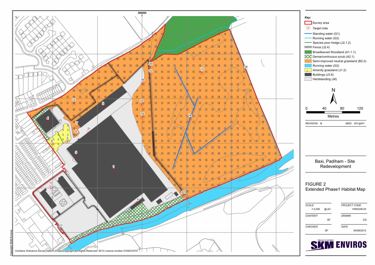
A description of the habitats present within the survey area and an assessment of their potential to
support key faunal species / species groups is given below. The text should be read in conjunction
with Figure 2, the Phase 1 habitat map and the Target notes provided in Appendix 1. A selection of
plates is provided in Appendix 2.
3.2.1. Habitats
A total of eight habitat types were identified within the survey area. These are shown in Figure 2
and listed below with the relevant Phase 1 habitat codes2.
Dense/continuous scrub (A2.1)
Semi-improved, neutral grassland (B2.2)
Standing water (G1)
Running water (G2)
Amenity grassland (J1.2)
Species poor hedge (J2.1.2)
Fence (J2.4)
Buildings (J3.6)
Hardstanding (J5)
The survey included four distinct areas as identified in Figure 1 and these are discussed separately
below.
Area 1 – Land occupied by the main BHC factory
The main factory site is predominantly hard standing and factory buildings. The main factory
buildings (Target note 1 & 2, Plate 1) are largely comprised of a brick base and corrugated sheet
upper walls and roofs. The roofs are well ventilated and have skylights to provide internal light.
Some areas of the main factory complex comprise offices (Target note 3, Plate 2). A separate
building in the north of the main factory site is comprised of a different structure (Target note 4,
Plate 3). This is a single storey construction with a sloping metal corrugated roof and double
glazing. Several other smaller, single storey buildings are located in the north of the site (Target
note 5, 6 and 7, Plates 4, 5 and 6). South of the main factory complex is a building previously used
as the Paint Store. This is a single story brick construction with a pitched sheet roof (Target note 8,
Plate 7).

SKM Enviros
K:\United Kingdom\Salford\VNIF\Projects\VN50248\Deliverables\Reports\Ecology\Phase 1 Habitat Survey\Issue 3\Baxi Padiham_Extended Phase 1
Habitat Survey Report_Issue_3_231013.docx PAGE 13
In the north west of the main factory site the boundaries are marked by planted broadleaved trees
(Target note 9, Plate 8). These include a variety of Acer species plus alder Alnus glutinosa, silver
birch Betula pendula, rowan Sorbus aucuparia and horse chestnut Aesculus hippocastannum.
Conifers have also been planted between the main factory complex and the building in the far north
of the site which is fronted by amenity grassland and has a laurel Prunus laurecerasus hedge
running up the path to its front (see Plate 3). Small areas of ornamental planting also exist in
association with some of the buildings.
The eastern boundary of the main site (Area 1) is marked by an area of rough grassland and scrub
(Target note 10, Plate 9). The boundary itself is delineated by an embankment and a fence.
Meadow foxtail Alopecurus pratensis is abundant within the grassland and herbs and ruderal
species recorded here include broadleaved dock Rumex obtusifolius, dandelion Taraxacum
officinale agg., ribwort plantain Plantago lanceolata, thistle Cirsium sp, creeping buttercup
Ranunculus repens, creeping cinquefoil Potentilla reptans and common horsetail Equisetum
arvense. Areas of woody and bramble Rubus fruticosus agg. scrub are present and in wetter areas
there is a layer of bryophytes with occasional sedges Carex sp.
Area 2 - Land occupied by Rapid IT Parts and Craggs Energy Oil Depot
This area is fenced off from the main site and consists of hardstanding, two buildings and a series
of oil storage tanks (Target note 11, Plates 10 & 11). The buildings here comprise office and
storage space and have pitched sheet roofs. They are occupied and tankers regularly visit the site to
collect heating oil from the storage tanks located here.
Area 3 - Open space located to the north of the factory
North of the main factory buildings is an area of rough grassland which is fenced off from the main
site (Target note 12, Plate 12). Meadow foxtail is dominant here and in wetter areas patches of rush
Junucs sp. were recorded. Other species recorded here included raspberry Rubus idaeus , common
hogweed Heracleum sphondylium, common nettle Urtica dioica and creeping buttercup,
willowherb Epilobium sp, common cleavers Galium aparine, lesser celandine Ficaria vernaand
cow parsley Anthiriscus sylvestris. The northern boundary of the site is formed of a dense line of
hawthorn Crataegus monogyna.
Area 4 - Agricultural land located to the east of the factory
This area of grassland is owned by BHL and rented to a tenant farmer who uses it for grazing sheep
(Target note 13, Plate 13). The grassland here is kept short by grazing. Large parts of the field are
damp and dominated by rush Juncus sp.

SKM Enviros
K:\United Kingdom\Salford\VNIF\Projects\VN50248\Deliverables\Reports\Ecology\Phase 1 Habitat Survey\Issue 3\Baxi Padiham_Extended Phase 1
Habitat Survey Report_Issue_3_231013.docx PAGE 14
Large ditches have been dug in the centre of the field to drain the site with the central ditch running
c. 100m in length and being c. 5m wide (Target note, 14, plate 14). These ditches have recently
been cleared out meaning the grassland around them has been disturbed by vehicles and the banks
are bare mud.
There is a small pond located within the field (Target note 15, Plate 15). This is surrounded by rush
Juncus sp. and is approximately 5m x 2m in area and 5-10cm deep.
The eastern boundary of this field is marked by a stream (Target note 16, Plate 16). 21. This is
flowing and 10-50cm deep and c. 3m wide. The stream is lined by occasional hawthorn and
supports a range of emergent and marginal vegetation.
3.2.2. Invasive Plant Species
Two stands of giant hogweed were recorded on site along an embankment in the far west of the
main site (Area 1) (Target note 17) (SD 7981733909). No Japanese knotweed was recorded on site
but a stand was recorded along the embankment of the River Calder immediately south of the site
(Target note 22) (SD 80020 33939).
3.3. Fauna
3.3.1. Amphibians
Records for the common toad, common frog, smooth newt and great crested newt (GCN) were
identified within 2km of the site in the desk study data provided by LERN. The records for GCN
are from 2010 c. 2km north-east of the site at Higham.
There are no water bodies in Areas 1-3 of the site. Area 2 is comprised completely of hardstanding
and buildings and as such offer no suitable habitats for amphibians. The eastern boundary of Area 1
and all of Area 3 offer potential terrestrial habitats for amphibians in the form of rough grassland
and scrub and discarded materials which form potential refuge habitats (see Plates 17 & 18, Target
note 18 & 19).
Two water bodies were identified within Area 4, a small pond (Target note 15, Plate 15) and the
series of ditches recently dug out within the centre of the field (Target note 14, Plate 14). In
addition a large water body c. 100m x 20m was identified in the adjacent field (Plate 19) to the
east. This water body was located in the centre of a field and surrounded by rushes Juncus sp. The
water body supports emergent vegetation and is fringed by occasional patches of bulrush Typha
latifolia.

SKM Enviros
K:\United Kingdom\Salford\VNIF\Projects\VN50248\Deliverables\Reports\Ecology\Phase 1 Habitat Survey\Issue 3\Baxi Padiham_Extended Phase 1
Habitat Survey Report_Issue_3_231013.docx PAGE 15
An HSI assessment of these water bodies for their potential to support GCN rated them as follows:
Small pond Area 4 (Target note 16) – Below average
Ditches Area 4 (Target note 15) – Good*
Offsite water body – Excellent
Details of the assessment are included in Appendix 3.
*The HSI assessment does not account for the fact that these ditches have recently been cleared out
which is likely to reduce their potential to support breeding GCN given the inevitable disturbance
this would cause and the fact that egg laying materials will have been stripped from the base and
sides of the ditches.
Broadleaved woodland to the north of Area 4 provides potential high quality terrestrial habitat for
amphibians. A pond located within 500m of the site but south of the River Calder in Bancrofts
Plantation is not included in the assessment here as the River is considered likely to form a barrier
to any movements of newts from this pond to the site.
3.3.2. Reptiles
No records of reptiles within 2km of the site were identified during the desk study.
Area 2 is composed entirely of hardstanding and buildings and therefore offers no potential habitat
for reptiles. Area 1 is also predominantly hardstanding and buildings although scrub and rough
grassland habitats in the east of Area 2 (Target note 10) with the associated embankment and
potential refuge habitats (Target note 18 and 19) offer potential habitat for reptiles. Likewise rough
grassland habitat in Area 3 offers potential reptile habitat. Area 4 is largely considered unsuitable
for reptiles as it comprises closely grazed grassland although suitable reptile habitat does exist on
the boundary of this Area along the stream (Target note 16).
3.3.3. Otter and water vole
No records of otter or water vole within 2km of the site were identified during the desk study.
No water courses are present in Area 1-3 and these areas offer no potential for otter or water vole
which are riparian mammals, generally found in close proximity to suitable watercourses. The
stream which runs along the eastern boundary of Area 4 (Target note 16) offers potential water vole
habitat with soft grassy earth banks suitable for burrows and a variety of food sources in the
emergent and marginal plant species and grasses. The River Calder which runs adjacent to the site
to the south provides potentially suitable habitat for otter.

SKM Enviros
K:\United Kingdom\Salford\VNIF\Projects\VN50248\Deliverables\Reports\Ecology\Phase 1 Habitat Survey\Issue 3\Baxi Padiham_Extended Phase 1
Habitat Survey Report_Issue_3_231013.docx PAGE 16
3.3.4. Badger
No records of badger within 2km of the site were identified during the desk study.
Badger has been observed frequently on the main factory site (Area 1) by the 24 hour security
personnel (pers. comm). Area 2 is considered unsuitable for badger as it is comprised entirely of
buildings and hardstanding. Grassland habitat in Area 1 and 3 are considered to provide suitable
foraging habitat for badger and a potential outlier badger sett was noted on the eastern boundary of
Area 1 in the embankment which runs along the fenceline (Target note 20, Plate 20). A notable
amount of earth had been excavated to create to the single hole which was ‘D’ shaped and c. 30cm
wide. No evidence of badger was observed in Area 4 although this could provide suitable foraging
habitat. Woodland which borders Area 4 to the north is likely to provide good habitat for badgers
setts and foraging.
3.3.5. Bats
Records for the common pipistrelle were provided from within 2km of the site by the LERN data
search.
Table 3 below provides an assessment of the buildings on site for bats based on BCT guidelines4
Table 8.2. Overall the buildings are considered to have a low likelihood of supporting roosting bats
as there are few opportunities for access, buildings are primarily composed of prefabricated steel
and sheet materials and have no roof voids.
Table 3 – Value of buildings on site for bats
Target note
Plate Building Description Potential bat roost features
Likelihood of bats being present
1 1 Main factory buildings which are predominantly composed of a brick base and corrugated asbestos upper walls and roofs. The roofs are well ventilated and comprise skylights to provide internal light.
None noted Lower
2 1 As above None noted Lower
3 2 Office section of main factory complex. Three stories with double glazing and a flat roof. Concrete and stone cladding to front and side.
None noted Lower

SKM Enviros
K:\United Kingdom\Salford\VNIF\Projects\VN50248\Deliverables\Reports\Ecology\Phase 1 Habitat Survey\Issue 3\Baxi Padiham_Extended Phase 1
Habitat Survey Report_Issue_3_231013.docx PAGE 17
Target note
Plate Building Description Potential bat roost features
Likelihood of bats being present
4 3 & 21 Single story, brick construction with a sloping metal corrugated roof and facia and double glazing.
A series of open vents into the walls (Plate 21) offer access to the brickwork as do cracks in the structure.
Lower
5 4 Small, single story building with a flat, felt roof and wooden facia.
Small holes in wall
Lower
6 5 Small, single story brick construction with corrugated plastic roof and pebble dash facia around front door.
None Lower
7 6 Garage with pebble dash walls and corrugated metal roof and wooden facia above door.
None Lower
8 7 Single story brick construction with a pitched asbestos roof.
Cracks in brickwork and missing bricks.
Lower
11 10&11 Office and storage space with brick and stone frontage, double glazing and pitched asbestos roofs.
None Lower
None of the trees on site were considered to have the potential to support bats as these trees were
generally not mature and did not display features such as lifted bark, rot holes, broken branches or
ivy which would offer roosting opportunities for bats.
Overall the potential development site is considered to have a low-moderate value for bats. Areas 1
& 2 are considered to be of low value as they are predominantly hard standing with buildings with
low bat roost potential. Areas 3 & 4 offer potential foraging habitat and therefore are of potentially
moderate value to bats. The assessment is made with reference to landscape features beyond the
site which may influence the likely presence of bats on site. Specifically here the presence of the
River Calder adjacent to the southern boundary of the site is considered an important linear feature
in the landscape that is likely to be used by bats for foraging and commuting hence increasing the
likelihood that bats will be present in the area of the site.

SKM Enviros
K:\United Kingdom\Salford\VNIF\Projects\VN50248\Deliverables\Reports\Ecology\Phase 1 Habitat Survey\Issue 3\Baxi Padiham_Extended Phase 1
Habitat Survey Report_Issue_3_231013.docx PAGE 18
3.3.6. Birds
Barn owl has been observed on site previously by the 24 hour security personnel although not in
the last couple of years (pers. comm) and there is evidence of a previous barn owl nest/roost on the
southern end of the main factory complex (Target note 21).
Trees, buildings and scrub on the site all provide suitable bird nesting habitat. The fields that
comprise Area 4 offer potential nesting habitat for breeding waders. Whilst no dedicated breeding
bird survey was conducted here, incidental records of breeding birds were made during the course
of additional ecology surveys (reported on separately) conducted here. Lapwing Vanellus vanellus
and reed bunting Emberiza schoeniclus were observed to be breeding in Area 4 in May during
surveys for newts by SKM. Curlew Numenius arquata was also noted to be present in the area but
were not observed to be breeding on site. Lapwing, curlew and reed bunting are all NERC Section
41 Species of Principal Importance in England. Sedge warbler Acrocephalus schoenobaenus were
considered to be possibly breeding in Area 4 but not confirmed.
Additional incidental bird records made during the survey included:
Magpie Pica pica – Area 1
Carrion Crow Corvus corone – Area 1
Woodpigeon Columba palumbus - Area 1
Oystercatcher Haematopus ostralegus - Area 1
Robin Erithacus rubecula – Area 1
Mallard Anas platyrhynchos – Area 4
Grey Heron Ardea cinerea – Area 4
House martin Delichon urbicum – Area 4 and over the River Calder
Peter Hornby, a local naturalist, surveys Area 4 monthly between September and March for
wintering snipe. The field here is considered to be of county value (pers comm. Peter Hornby) for
common snipe Gallinago gallinago and Jack snipe Lymnocryptes minimus and is registered as a
Wetland Bird Survey site for the British Trust for Ornithology (BTO). At present the tenant farmer
keeps the field lightly grazed by sheep and cuts back rush encroachment once it reaches the thatch
stage. This is considered to maintain the fields suitability of wetland birds (pers comm. Peter
Hornby).

SKM Enviros
K:\United Kingdom\Salford\VNIF\Projects\VN50248\Deliverables\Reports\Ecology\Phase 1 Habitat Survey\Issue 3\Baxi Padiham_Extended Phase 1
Habitat Survey Report_Issue_3_231013.docx PAGE 19
3.3.7. Other
Hedgehog, a Section 41 species (NERC Act) has been observed on site in Area 1 by 24-hour
security (pers. comm.)

SKM Enviros
K:\United Kingdom\Salford\VNIF\Projects\VN50248\Deliverables\Reports\Ecology\Phase 1 Habitat Survey\Issue 3\Baxi Padiham_Extended Phase 1
Habitat Survey Report_Issue_3_231013.docx PAGE 20
4. Potential Constraints and Recommendations for Further Surveys
4.1. Designated Sites
There are no designated sites, statutory or non-statutory, on are adjacent to the site. The nearest
designated site is a non-statutory BHS located 850m from the site designated for its terrestrial
habitat interest. No pathways to impacts on designated sites are anticipated as a result of the
development and as such designated sites are not considered to pose a constraint to the
development.
4.2. Habitats
The habitats in Areas 1 & 2 are considered to be of low ecological value as they are predominantly
hardstanding and buildings. Whilst the grassland habitats in Areas 3 & 4 are considered to be of
more value to wildlife, these habitats are not considered to be species rich or specifically valuable
in themselves and as such are not considered to pose a constraint to the development. Given the
proximity of the River Calder to the site, consideration should be given to the Environment
Agency’s Pollution Prevention Guidelines (PPGs) for working near water to prevent any pollution
of this water course.
4.3. Invasive species
Giant hogweed has been recorded on site within Area 1. This species is listed on Schedule 9 of the
Wildlife and Countryside Act (1981) as amended and it is an offense to allow or encourage the
spread of this plant. This includes moving contaminated soil from one place to another or
incorrectly handling and transporting contaminated material and cuttings. In addition giant
hogweed stems leaves and sap, contain several photosensitizing furanocoumarins. In contact with
the human skin and in combination with ultraviolet radiation, these compounds cause burning of
the skin. Immediately off-site on the banks of the River Calder, a patch of Japanese knotweed was
also recorded. This is another Schedule 9 species.
It is recommended that an invasive species management plan is developed detailing how these
species will be dealt with to ensure no offence is committed during site clearance and construction
works.
4.4. Amphibians
Areas 1-3 do not support any standing water and as such are of no value to breeding amphibians
although grassland and scrub in Areas 1 & 3 do provide potentially suitable terrestrial habitat for
amphibians.

SKM Enviros
K:\United Kingdom\Salford\VNIF\Projects\VN50248\Deliverables\Reports\Ecology\Phase 1 Habitat Survey\Issue 3\Baxi Padiham_Extended Phase 1
Habitat Survey Report_Issue_3_231013.docx PAGE 21
The small pond (Target note 15) and ditches (Target note 14) in Area 4 have the potential to
support breeding amphibians including GCN although the fact that the ditches are regularly cleared
out may reduce their potential value to breeding amphibians by virtue of disturbance and the
removal of vegetation for egg laying. A large water body the field to the east of Area 4 and within
500m of Area 1 was also considered to have the potential to support GCN.
GCN is fully protected through its inclusion in Schedule 5 of the Wildlife and Countryside Act
1981 (as amended) and Schedule 2 of the Conservation of Habitat and Species Regulations 2010 as
a European protected species. Under the legislation, it is an offence to intentionally kill, injure or
take a GCN as well as intentionally or recklessly damage, destroy or obstruct access to any
structure or place used for shelter or protection by a GCN or disturb an animal while it is occupying
a structure or place which it uses for that purpose. The legislation applies to GCN in both aquatic
and terrestrial habitats and to all life stages. GCN is also listed on Section 41 of The NERC Act
(2006) as a species of principal importance for the conservation of biodiversity in England and is a
Lancashire LBAP species.
Standard guidelines6 recommend that all water bodies considered to have the potential to support
GCN within 500m of a proposed development should be surveyed for GCN. All of the water
bodies described above are within 500m of the proposed development site. From a review of the
OS 1:25,000 map, an additional water body to those identified above is present within 500m of the
site at Bankcrofts Plantaion (SD 80230 33972). However, as this is located south of the River
Calder, which is likely to act as a barrier to the potential movement of any GCN from here onto
site, it is not considered necessary to include this in any surveys related to the proposed
development of the Baxi Heating site.
Standard guidelines recommend that to determine whether GCN are present or absent, four survey
visits should be undertaken between mid- March to mid-June with at least two of the visits during
mid-April to mid-May. The two ponds and the ditches identified during the Phase 1 Habitat survey
should be surveyed for GCN using standard survey techniques. During each visit at least three of
the following survey methods must be employed:
Torch Survey – On each evening the entire perimeter of each water body should be surveyed
for great crested newts after dark using a high powered torch.
Bottle traps – Bottle traps should be placed around the perimeter of each water body on each
evening and checked the following morning to determine whether newts are present or absent.
6 English Nature (2001). Great Crested Newt Mitigation Guidelines.

SKM Enviros
K:\United Kingdom\Salford\VNIF\Projects\VN50248\Deliverables\Reports\Ecology\Phase 1 Habitat Survey\Issue 3\Baxi Padiham_Extended Phase 1
Habitat Survey Report_Issue_3_231013.docx PAGE 22
Egg searches – Vegetation within the water body should be inspected during the day to
determine
Netting – Using a long-handled dip-net GCN can be captured by sampling the area around the
pond edge.
If GCN are located within any of the water bodies being assessed, in accordance with the
guidelines, two additional surveys may be required in order to estimate the population size class
dependant on whether any of the water bodies will be lost or damaged by the proposed
development as well as how much terrestrial habitat will be lost.
4.5. Reptiles
Whilst the majority of the site was of limited potential value to reptile species, some areas of
habitat were considered to offer potential reptile habitat. Scrub and rough grassland habitats in the
east of Area 2 (Target note 10) with the associated embankment and potential refuge habitats
(Target note 18 and 19) offer potential for reptiles. Likewise rough grassland habitat in Area 3
offers potential reptile habitat. Area 4 was largely considered unsuitable for reptiles as it comprises
closely grazed grassland although suitable reptile habitat does exist on the boundary of this Area
along the stream (Target note 16). Species that could be present include the Lancashire LBAP
species slow worm Anguis fragilis, grass snake Natirx natrix and common lizard Zootoca vivipara.
All reptile species, receive partial protection through inclusion in Schedule 5 of the Wildlife and
Countryside Act 1981 (as amended) in respect of Sections 9(1) and 9(5) which makes it an offence
to intentionally kill, injure or sell these animals. All six species of UK reptile are also listed as
Section 41 species.
Given the potential for reptiles to be present a dedicated reptile survey is recommended to cover all
areas of potential reptile habitat which may be impacted by the development. The results of this
survey will them inform an appropriate mitigation strategy for reptiles, should this be required, to
ensure no reptiles are injured or killed during works.
Surveys should follow standard methodology7,8
. This involves placing several sheets of dark
material (either black roofing felt or corrugated metal sheeting) in suitable habitat. The sheets
7 Froglife (1999). Reptile survey: an introduction to planning, conducting and interpreting surveys for snake
and lizard conservation. Froglife Advice Sheet 10. Froglife: Halesworth.
8 Herpetofauna Groups of Britain and Ireland. 1998. Evaluating local mitigation / translocation programmes:
maintaining best practice and lawful standards. HGBI. advisory notes for Amphibian and Reptile Groups
(ARGs.). Halesworth, Suffolk, HGBI.

SKM Enviros
K:\United Kingdom\Salford\VNIF\Projects\VN50248\Deliverables\Reports\Ecology\Phase 1 Habitat Survey\Issue 3\Baxi Padiham_Extended Phase 1
Habitat Survey Report_Issue_3_231013.docx PAGE 23
should be placed on the first visit and left for approximately one week to allow any reptiles present
to habituate to them. Then, a series of seven visits in suitable weather conditions (taken as air
temperature between 8° - 18°C, avoiding windy, rainy or excessively cloudy days) should be
undertaken and reptile species (including gender where possible) and numbers recorded..
Recommended survey times are between late March and early October (weather dependent).
Surveys can be limited by high temperatures during July and August with peak survey months
being April, May and September.
4.6. Otter and Water Vole
Habitat suitable for water vole and/or otter was identified adjacent to the site on the River Calder
and along the eastern boundary of the site in the form of a stream.
Water vole is fully protected through its inclusion in Schedule 5 of the Wildlife and Countryside
Act 1981 (as amended). Under the legislation it is an offence to intentionally kill or injure a water
vole as well as intentionally or recklessly damage, destroy or obstruct access to any structure or
place which water voles use for shelter or protection, or disturb water voles whilst they are using
such a place. Water vole is also a Section 41 and Lancashire LBAP species
Otter is fully protected through its inclusion in Schedule 5 of the Wildlife and Countryside Act
1981 (as amended) and Schedule 2 of the Conservation of Habitat and Species Regulations 2010 as
a European protected species. Under the legislation, it is an offence to intentionally kill, injure or
take an otter as well as intentionally or recklessly damage, destroy or obstruct access to any
structure or place used for shelter or protection by an otter or disturb an animal while it is
occupying a structure or place which it uses for that purpose. Otter is also a Section 41 and
Lancashire LBAP species.
An otter and water vole survey should be conducted along the River Calder adjacent to the
development site and the stream that runs along the boundary of Area 4. As these species both
inhabit the banks of watercourses, surveys for these species can be undertaken together. In
accordance with the standard survey guidelines9,10
a survey should comprise walking the
river/stream banks to search for signs of water vole and/or otter presence, including but not limited
9 Strachan R & Moorhouse T (2006) Water vole conservation handbook, second edition, Wildlife
Conservation Research Unit.
10 Chanin P (2003) Monitoring the otter Lutra lutra, Conserving Natura 2000 Rivers, Monitoring Series No.
10, English Nature.

SKM Enviros
K:\United Kingdom\Salford\VNIF\Projects\VN50248\Deliverables\Reports\Ecology\Phase 1 Habitat Survey\Issue 3\Baxi Padiham_Extended Phase 1
Habitat Survey Report_Issue_3_231013.docx PAGE 24
to holts/burrows, latrines/spraints, footprints, feeding remains and sightings of animals. The survey
should be conducted between April and September.
4.7. Badger
Badger has been observed in Area 1 by security personnel on site and a potential outlier badger sett
was observed on the eastern boundary of Area 1.
Badgers receive protection under The Protection of Badgers Act 1992. The Act is based primarily
on the need to protect badgers from baiting and deliberate harm or injury however it contains
restrictions that apply more widely. All the following are criminal offences:
to willfully kill, injure, take, possess or cruelly ill-treat a badger;
to attempt to do so; or
to intentionally or recklessly interfere with a sett.
Sett interference includes damaging or destroying a sett, obstructing access to a sett, and disturbing
a badger whilst it is occupying a sett. It is not illegal, and therefore a licence is not required, to
carry out disturbing activities in the vicinity of a sett if no badger is disturbed and the sett is not
damaged or obstructed . If works are likely to cause sett interference a license will be required
from Natural England licence.
It is recommended that surveys for badger are updated prior to works commencing to ensure up-to-
date survey data is available on the precise location of active badger setts and early consultation
with a Natural England representative with regards potential disturbance to badgers is advised.It
should be noted that should this sett prove to be active and as such require closure licence will be
required and sett closure would need to take place between July and November.
4.8. Bats
The buildings on site and the development site as a whole are considered to have low and low-
moderate potential to support roosting and foraging bats respectively.
All British bat species are fully protected at national and European levels, through their inclusion in
Schedule 5 of the Wildlife and Countryside Act 1981 (as amended) and in Schedule 2 of the
Conservation of Habitat and Species Regulations 2010. Under this legislation, it is an offence to
deliberately kill, injure or take a bat as well as intentionally or recklessly damage, destroy or
obstruct access to any structure or resting place used for shelter or protection by a bat or disturb an
animal while it is occupying a structure or place which it uses for that purpose. A number of bat
species are also listed at Section 41 species and Lancashire LBAP species.

SKM Enviros
K:\United Kingdom\Salford\VNIF\Projects\VN50248\Deliverables\Reports\Ecology\Phase 1 Habitat Survey\Issue 3\Baxi Padiham_Extended Phase 1
Habitat Survey Report_Issue_3_231013.docx PAGE 25
In order to further determine the development sites value for bats it is recommended that dedicated
bat surveys are undertaken. Three transect surveys, covering all areas of the site are recommended
to be undertaken spread across several months and to be supplemented by automated recordings set
on each survey occasion and taken over three nights. This level of survey effort is consistent with
that recommended by the Bat Conservation Trust, Bat Survey Guidelines4 for medium sized
development projects in low quality bat habitats. Transects should repeat the same pre-determined
route and last 2-3 hours. They should include both dawn and dusk transects and incorporate
listening stops of 3-5 mins along the route.
Should any bat roosts be detected during these surveys that may be disturbed by the works then,
further roost surveys may be required and it may be necessary to obtain an EPS licence via Natural
England before works can proceed.
4.9. Birds
All wild birds in the UK are protected under Section 1 of the Wildlife and Countryside Act 1981
(as amended) which makes it an offence to intentionally kill, injure or take any wild bird or take,
damage or destroy the nest (whilst being built or in use) or its eggs. Barn owls, amongst other
species, receive further protection under Schedule 1 of the 1981 Act which makes it an offence to
intentionally or recklessly disturb these species while building a nest or in, on or near a nest
containing eggs or young; or to disturb dependent young of such a bird.
It is recommended that a dedicated barn owl survey is undertaken of the buildings on site by a
suitably licensed bird surveyor to ascertain the up-to-date status of barn owl on site.
In general any works affecting potential bird nesting habitat i.e. building demolition, clearance of
standing vegetation, landscaping (e.g. Area 4) , should be carried out outside the breeding season
(generally accepted as March to August inclusive for most species). If this is not possible, any
potentially suitable nesting habitat should be checked for nests by a suitably qualified ecologist
immediately prior to its removal. If nests are found further work would need to be delayed until
young have fledged and left the nest.
Careful consideration should be given to any plans for landscaping in Area 4 of the site as this
already provides valuable habitat for wading birds (both wintering and breeding) and any plans for
changing the use of this land should take into account the value it already provides to wildlife.

SKM Enviros
K:\United Kingdom\Salford\VNIF\Projects\VN50248\Deliverables\Reports\Ecology\Phase 1 Habitat Survey\Issue 3\Baxi Padiham_Extended Phase 1
Habitat Survey Report_Issue_3_231013.docx PAGE 26
5. Opportunities for Biodiversity Enhancement
In accordance with the National Planning Policy Framework, opportunities should be sought where
possible for nature conservation enhancement at this site. Opportunities for enhancement should be
identified based on the results of the surveys recommended above but may include the provision of
bird and bat boxes, including barn owl boxes, and the creation of reptile and amphibian refugia.
It may be possible to enhance Area 4 for breeding waders such as lapwing and curlew although
consideration should also be given to the requirements of wintering waders for which this site is
already known to be important. Proposals to enhance this area for breeding waders should also
consider the limitations posed to small sites like this in urban areas as a result of high predation
levels. It is understood that discussions relating to enhancement of this site for water birds have
previously been held with the RSPB (pers. comm. Peter Hornby) and any future enhancement plans
would best be undertaken in consultation with the RSPB and the Lancashire Wildlife Trust.

SKM Enviros
K:\United Kingdom\Salford\VNIF\Projects\VN50248\Deliverables\Reports\Ecology\Phase 1 Habitat Survey\Issue 3\Baxi Padiham_Extended Phase 1
Habitat Survey Report_Issue_3_231013.docx PAGE 27
Figures
Figure 1: Site Plan
Figure 2: Phase 1 habitat map

380000
FIGURE 1Site Plan
Baxi, Padiham - Site Redevelopment
1:2,000
±
SCALE
CONTENT
CHECKED
PROJECT CODE
DRAWN
DATE
SF CD
SF 04/06/2013
@ A3
REVISION: B MXD: 002/g002
VN50248.04
Copy
right
SKM
Envir
os
Key:Survey area
Area1234
0 50 100Metres
Contains Ordnance Survey Data © Crown Copyright, All Rights Reserved. 2013 Licence number 0100031673.
|| | | || | | | |
| | | | || | | | |
| | | | || | | | |
| | | | || | | |||| | | | | | | | | | | | | | | | | | | | | | | | | | | | | | | | | | |||||||||||||||||||||||||||||||||||||||||||||
||||||||
||||||||
||||||||
|||||||| ||| | |||| | | | | | | | | | | | | | || | ||| | | || | | | | | | | | | | | | | | | | |
|| | || || | | | || | || || | || | || || | | |
| | | | || | | | |
| | | | || | | ||
|| | | | | | | | | | |
| | | | | | | | | | | | | | | | | | | | | | | | | | || | | | |
| || | || | | | |
| | | | || | | | |
| | |
||||||||
|||||| | | | |
| | | | || | | | |
| | | | || | | | |
| | | | || | | |
||||||||
||||||||
| || | | | | | | | | | | | ||| | | |
| | | || | | |
| | | || | | |
| | | ||| | |
| | | ||| || || | || |||||| ||||| || || | | || | || | | || | || | || || | | || | || | | || | | || | || | | || | || | | || | || | | || | || | | || | || | | || | | || | || | | ||||||
||||||
||||||
||||||
||| || | | || | || | | || | | || | || | | || | | | | | | | | | | || | | | | | | | || | | | | | | | | || | | | | | | | || | | | | || || | | ||| || | |
.
.
.
.
.
.
.
.
.
.
.
.
.
.
..
.
.
.
.
.
.
9
8
7
65
4
3
2
1
22
21
20
19
18
17
1615
14
13
12
11
10
380000
FIGURE 2Extended Phase1 Habitat Map
Baxi, Padiham - Site Redevelopment
1:2,000
±
SCALE
CONTENT
CHECKED
PROJECT CODE
DRAWN
DATE
SF CD
SF 04/06/2013
@ A3
REVISION: B MXD: 001/g001
VN50248.04
Copy
right
SKM
Envir
os
Key:Survey area
. Target noteStanding water (G1)Running water (G2)Species poor hedge (J2.1.2)
| | | | | | | | Fence (J2.4)Broadleaved Woodland (A1.1.1)Dense/continuous scrub (A2.1)
IS IS Semi-improved neutral grassland (B2.2)Running water (G2)
A A AA A AAmenity grassland (J1.2)
Buildings (J3.6)Hardstanding (J6)
0 40 80 120Metres
Contains Ordnance Survey Data © Crown Copyright, All Rights Reserved. 2013 Licence number 0100031673.

SKM Enviros
K:\United Kingdom\Salford\VNIF\Projects\VN50248\Deliverables\Reports\Ecology\Phase 1 Habitat Survey\Issue 3\Baxi Padiham_Extended Phase 1
Habitat Survey Report_Issue_3_231013.docx PAGE 28
Appendix 1 – Target Notes

SKM Enviros
K:\United Kingdom\Salford\VNIF\Projects\VN50248\Deliverables\Reports\Ecology\Phase 1 Habitat Survey\Issue 3\Baxi Padiham_Extended Phase 1
Habitat Survey Report_Issue_3_231013.docx PAGE 29
Target note
Plate Notes
1 & 2 1 The main factory buildings are largely comprised of a brick base and corrugated asbestos upper walls and roofs. The roofs are well ventilated and comprise skylights to provide internal light.
3 2 Some areas of the main factory complex comprise offices. These are three story, flat roofed offices with UPVC double glazing which are brick on level one with concrete and stone cladding on levels 2 & 3.
4 3 & 21 This is a single story construction with a sloping metal corrugated roof and double glazing. Holes in walls where vents used to be provide potential access for birds and bats. Bats could access brickwork here and via cracks in brickwork and possible lead flashing.
5 4 Small, single story building with a flat, felt roof and wooden facia. Small holes in wall could provide bat/ bird roosting/nesting opportunities.
6 5 Small, single story brick construction with corrugated plastic roof and pebble dash facia around front door.
7 6 Garage with pebble dash walls and corrugated metal roof and wooden facia above door.
8 7 Single story brick construction with a pitched asbestos roof. Cracks in brickwork and missing bricks provide potential bat roosting opportunities.
9 8 Boundaries marked by planted broadleaves. These broadleaves include a variety of Acer species plus alder Alnus glutinosa, birch Betula pendula, rowan Sorbus aucuparia and horse chestnut Aesculus hippocastannum.
10 9 Area of rough grassland and scrub. The boundary itself is delineated by an embankment and a fence. Meadow foxtail Alopecurus pratensis is abundant within the grassland and herbs and ruderal species recorded here include broadleaved dock Rumex obtusifolius, dandelion Taraxacum officinale agg., ribwort plantain Plantago lanceolata, thistle Cirsium sp, creeping buttercup Ranunculus repens, creeping cinquefoil Potentilla reptans and common horsetail Equisetum arvense. Areas of woody and bramble Rubus fruticosus agg. scrub are present and in wetter areas there is a layer of bryophytes with occasional sedges Carex sp.
11 10 & 11 Land occupied by Rapid IT Parts and Craggs Energy Oil Depot. This area is fenced off from the main site and consists of hardstanding, two buildings and a series of oil storage tanks The buildings here comprise office and storage space and have pitched asbestos roofs. They are occupied and tankers regularly visit the site to collect heating oil from the storage tanks located here.
12 12 North of the main factory buildings is an area of rough grassland which is fenced off from the main site. Meadow foxtail is dominant here and in wetter areas patches of rush Junucs sp. were recorded. Other species recorded here included raspberry Rubus idaeus , common hogweed Heracleum sphondylium, common nettle Urtica dioica and creeping buttercup, willowherb Epilobium sp, common cleavers Galium aparine, lesser celandine Ranunculus ficaria and cow parsley Anthiriscus sylvestris.
13 13 This area of grassland is owned by BHL and rented to a tenant farmer who uses it for grazing sheep. The grassland here is kept short by grazing. Large parts of the field are damp and dominated by rush Juncus sp.
14 14 Large ditches dug in the centre of the field to drain the site with the central ditch running c. 100m in length and being c. 5m wide. These ditches have recently been cleared out meaning the grassland around them has been

SKM Enviros
K:\United Kingdom\Salford\VNIF\Projects\VN50248\Deliverables\Reports\Ecology\Phase 1 Habitat Survey\Issue 3\Baxi Padiham_Extended Phase 1
Habitat Survey Report_Issue_3_231013.docx PAGE 30
Target note
Plate Notes
disturbed by vehicles and the banks are bare mud.
15 15 Small pond located within the field. This is surrounded by rush Juncus sp. and is approximately 5m x 2m in area and 5-10cm deep.
16 16 Stream flowing and 10-50cm deep and c. 3m wide. The stream is lined by occasional hawthorn and supports a range of emergent and marginal vegetation.
17 Two stands of giant hogweed recorded on site along an embankment in the far west of the main site (SD 7981733909).
18 & 19 17 & 18 Potential reptile and amphibian refuges.
20 20 Potential badger sett noted on the eastern boundary of Area 1 in the embankment which runs along the fenceline. A notable about of earth had been removed to create to the single hole which was ‘D’ shaped and c. 30cm wide.
21 Location of historical barn owl nest/roost on the southern end of the main factory complex.
22 Stand of Japanese knotweed outside the site boundary on the river bank.

SKM Enviros
K:\United Kingdom\Salford\VNIF\Projects\VN50248\Deliverables\Reports\Ecology\Phase 1 Habitat Survey\Issue 3\Baxi Padiham_Extended Phase 1
Habitat Survey Report_Issue_3_231013.docx PAGE 31
Appendix 2 – Plates

SKM Enviros
K:\United Kingdom\Salford\VNIF\Projects\VN50248\Deliverables\Reports\Ecology\Phase 1 Habitat Survey\Issue 3\Baxi Padiham_Extended Phase 1
Habitat Survey Report_Issue_3_231013.docx PAGE 32
Plate 1 – Main factory buildings on site (Target note 1)
Plate 2 – Office which form part of the main factory complex (Target note 3)

SKM Enviros
K:\United Kingdom\Salford\VNIF\Projects\VN50248\Deliverables\Reports\Ecology\Phase 1 Habitat Survey\Issue 3\Baxi Padiham_Extended Phase 1
Habitat Survey Report_Issue_3_231013.docx PAGE 33
Plate 3 – Single storey building in north of main site (Target note 4)
Plate 4 - Small single story building (Target note 5)

SKM Enviros
K:\United Kingdom\Salford\VNIF\Projects\VN50248\Deliverables\Reports\Ecology\Phase 1 Habitat Survey\Issue 3\Baxi Padiham_Extended Phase 1
Habitat Survey Report_Issue_3_231013.docx PAGE 34
Plate 5 Small single story building (Target note 6)
Plate 6 Garage (Target note 7)

SKM Enviros
K:\United Kingdom\Salford\VNIF\Projects\VN50248\Deliverables\Reports\Ecology\Phase 1 Habitat Survey\Issue 3\Baxi Padiham_Extended Phase 1
Habitat Survey Report_Issue_3_231013.docx PAGE 35
Plate 7 The old paint store (Target note 8)
Plate 8 Trees along the north western site boundary (Target note 9)

SKM Enviros
K:\United Kingdom\Salford\VNIF\Projects\VN50248\Deliverables\Reports\Ecology\Phase 1 Habitat Survey\Issue 3\Baxi Padiham_Extended Phase 1
Habitat Survey Report_Issue_3_231013.docx PAGE 36
Plate 9 Area of rough grassland and scrub (Target note 10)
Plate 10 – Area 2 occupied by Rapid IT and Craggs Energy (Target note 11)

SKM Enviros
K:\United Kingdom\Salford\VNIF\Projects\VN50248\Deliverables\Reports\Ecology\Phase 1 Habitat Survey\Issue 3\Baxi Padiham_Extended Phase 1
Habitat Survey Report_Issue_3_231013.docx PAGE 37
Plate 11 – Area 2 occupied by Craggs Energy (Target note 11)
Plate 12 – Area 3 Rough grassland (Target note 12)

SKM Enviros
K:\United Kingdom\Salford\VNIF\Projects\VN50248\Deliverables\Reports\Ecology\Phase 1 Habitat Survey\Issue 3\Baxi Padiham_Extended Phase 1
Habitat Survey Report_Issue_3_231013.docx PAGE 38
Plate 13 – Area 4, agricultural land east of the factory site (Target note 13)
Plate 14 Ditches in Area 4 (Target note 14)

SKM Enviros
K:\United Kingdom\Salford\VNIF\Projects\VN50248\Deliverables\Reports\Ecology\Phase 1 Habitat Survey\Issue 3\Baxi Padiham_Extended Phase 1
Habitat Survey Report_Issue_3_231013.docx PAGE 39
Plate 15 – Small pond in Area 4 (Target note 15)
Plate 16 Stream running along the eastern boundary of the site (Target note 16)

SKM Enviros
K:\United Kingdom\Salford\VNIF\Projects\VN50248\Deliverables\Reports\Ecology\Phase 1 Habitat Survey\Issue 3\Baxi Padiham_Extended Phase 1
Habitat Survey Report_Issue_3_231013.docx PAGE 40
Plate 17 Potential refugia habitat for amphibians and reptiles in Area 1(Target note 18)
Plate 18 Potential refugia habitat for amphibians and reptiles in Area 1(Target note 19)

SKM Enviros
K:\United Kingdom\Salford\VNIF\Projects\VN50248\Deliverables\Reports\Ecology\Phase 1 Habitat Survey\Issue 3\Baxi Padiham_Extended Phase 1
Habitat Survey Report_Issue_3_231013.docx PAGE 41
Plate 19 – Large offsite water body

SKM Enviros
K:\United Kingdom\Salford\VNIF\Projects\VN50248\Deliverables\Reports\Ecology\Phase 1 Habitat Survey\Issue 3\Baxi Padiham_Extended Phase 1
Habitat Survey Report_Issue_3_231013.docx PAGE 42
Plate 20 Potential outlier badger sett (Target note 20)
Plate 21 Potential bat access point in brickwork (Target note 4)

SKM Enviros
K:\United Kingdom\Salford\VNIF\Projects\VN50248\Deliverables\Reports\Ecology\Phase 1 Habitat Survey\Issue 3\Baxi Padiham_Extended Phase 1
Habitat Survey Report_Issue_3_231013.docx PAGE 43

SKM Enviros
K:\United Kingdom\Salford\VNIF\Projects\VN50248\Deliverables\Reports\Ecology\Phase 1 Habitat Survey\Issue 3\Baxi Padiham_Extended Phase 1
Habitat Survey Report_Issue_3_231013.docx PAGE 44
Appendix 3 – HSI Results
Water body Small on site pond (TN 15)
Ditches (TN 14) Offsite Pond
Location 1 1 1
Area m2 0.05 1.00 0.80
Pond permanence 0.60 1.00 1.00
Water quality 0.67 0.33 0.67
Shade % 1.00 1.00 1.00
Waterfowl 1.00 1.00 1.00
Fish 1.00 1.00 0.67
Pond Density 1.00 1.00 1.00
Terrestrial habitat quality 1.00 1.00 1.00
Macrophyte cover 0.30 0.30 0.40
HIS Sum 0.01 0.10 0.14
Final HIS Score 0.60 0.79 0.82
Prediction (Likelihood of GCN) Below Average
Good Excellent