Bathymetric Surface Product Specification
104
S-102 Published by the International Hydrographic Organization 4b quai Antoine 1 er Principauté de Monaco Tel: (377) 93.10.81.00 Fax: (377) 93.10.81.40 [email protected] www.iho.in Bathymetric Surface Product Specification Edition 2.0.0 – October 2019
Transcript of Bathymetric Surface Product Specification
S-102
Published by the International Hydrographic Organization
4b quai Antoine 1er Principauté de Monaco Tel: (377) 93.10.81.00
Fax: (377) 93.10.81.40 [email protected] www.iho.in
Bathymetric Surface Product Specification Edition 2.0.0 – October 2019
ii Bathymetric Surface Product Specification
S-102 October 2019 Edition 2.0.0
© Copyright International Hydrographic Organization 2019
This work is copyright. Apart from any use permitted in accordance with the Berne Convention
for the Protection of Literary and Artistic Works (1886), and except in the circumstances
described below, no part may be translated, reproduced by any process, adapted,
communicated or commercially exploited without prior written permission from the
International Hydrographic Organization (IHO). Copyright in some of the material in this
publication may be owned by another party and permission for the translation and/or
reproduction of that material must be obtained from the owner.
This document or partial material from this document may be translated, reproduced or
distributed for general information, on no more than a cost recovery basis. Copies may not be
sold or distributed for profit or gain without prior written agreement of the IHO Secretariat and
any other copyright holders.
In the event that this document or partial material from this document is reproduced, translated
or distributed under the terms described above, the following statements are to be included:
“Material from IHO publication [reference to extract: Title, Edition] is reproduced with the
permission of the IHO Secretariat (Permission No ……./…) acting for the International
Hydrographic Organization (IHO), which does not accept responsibility for the correctness of
the material as reproduced: in case of doubt, the IHO’s authentic text shall prevail. The
incorporation of material sourced from IHO shall not be construed as constituting an
endorsement by IHO of this product.”
“This [document/publication] is a translation of IHO [document/publication] [name]. The IHO has not checked this translation and therefore takes no responsibility for its accuracy. In case of doubt the source version of [name] in [language] should be consulted.”
The IHO Logo or other identifiers shall not be used in any derived product without prior written permission from the IHO Secretariat.
Bathymetric Surface Product Specification iii
S-102 October 2019 Edition 2.0.0
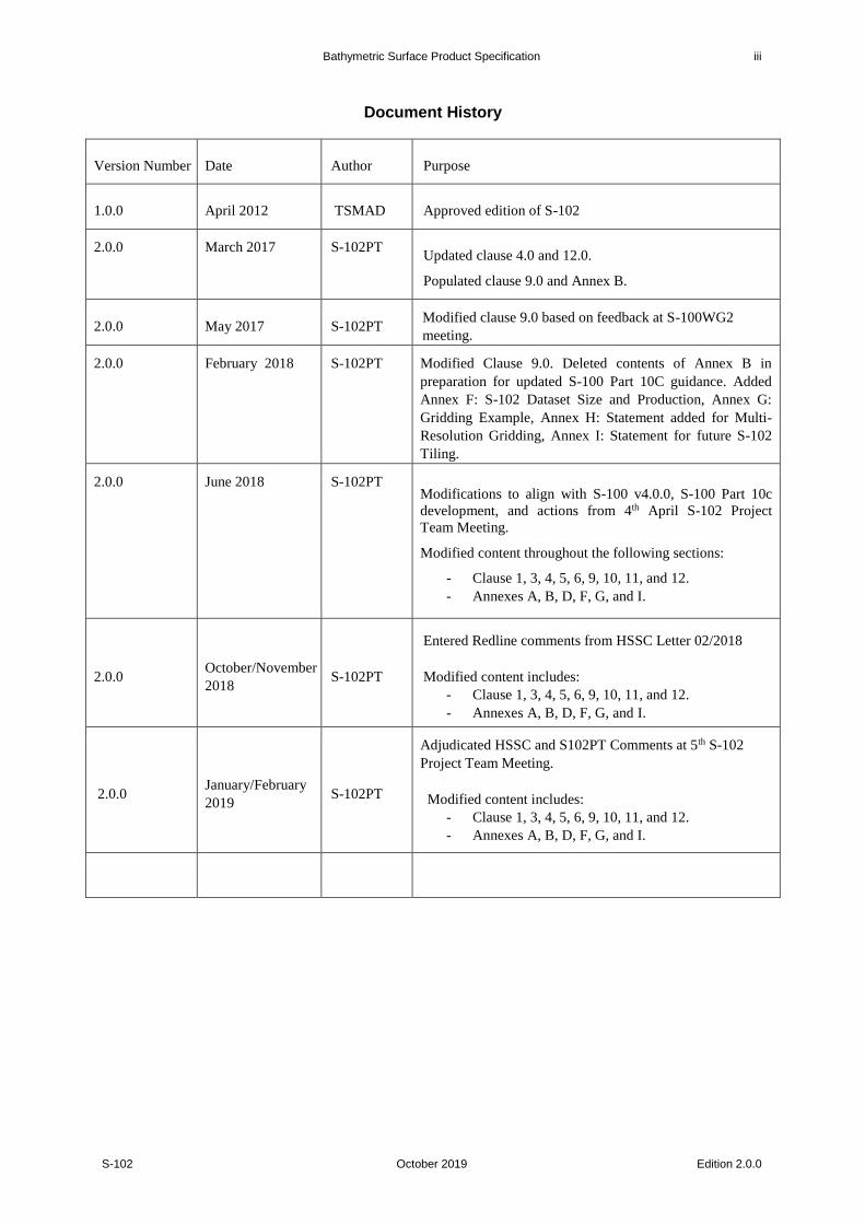
Document History
Version Number Date Author Purpose
1.0.0 April 2012 TSMAD Approved edition of S-102
2.0.0 March 2017 S-102PT Updated clause 4.0 and 12.0.
Populated clause 9.0 and Annex B.
2.0.0 May 2017 S-102PT Modified clause 9.0 based on feedback at S-100WG2
meeting.
2.0.0 February 2018 S-102PT Modified Clause 9.0. Deleted contents of Annex B in
preparation for updated S-100 Part 10C guidance. Added
Annex F: S-102 Dataset Size and Production, Annex G:
Gridding Example, Annex H: Statement added for Multi-
Resolution Gridding, Annex I: Statement for future S-102
Tiling.
2.0.0 June 2018 S-102PT Modifications to align with S-100 v4.0.0, S-100 Part 10c
development, and actions from 4th April S-102 Project
Team Meeting.
Modified content throughout the following sections:
- Clause 1, 3, 4, 5, 6, 9, 10, 11, and 12.
- Annexes A, B, D, F, G, and I.
2.0.0 October/November
2018 S-102PT
Entered Redline comments from HSSC Letter 02/2018
Modified content includes:
- Clause 1, 3, 4, 5, 6, 9, 10, 11, and 12.
- Annexes A, B, D, F, G, and I.
2.0.0 January/February
2019 S-102PT
Adjudicated HSSC and S102PT Comments at 5th S-102
Project Team Meeting.
Modified content includes:
- Clause 1, 3, 4, 5, 6, 9, 10, 11, and 12.
- Annexes A, B, D, F, G, and I.
iv Bathymetric Surface Product Specification
S-102 October 2019 Edition 2.0.0
Page intentionally left blank
Bathymetric Surface Product Specification v
S-102 October 2019 Edition 2.0.0
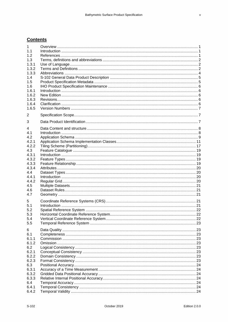
Contents
1 Overview ..................................................................................................................................... 1 1.1 Introduction ................................................................................................................................. 1 1.2 References .................................................................................................................................. 1 1.3 Terms, definitions and abbreviations .......................................................................................... 2 1.3.1 Use of Language ......................................................................................................................... 2 1.3.2 Terms and Definitions ................................................................................................................. 2 1.3.3 Abbreviations .............................................................................................................................. 4 1.4 S-102 General Data Product Description ................................................................................... 5 1.5 Product Specification Metadata .................................................................................................. 5 1.6 IHO Product Specification Maintenance ..................................................................................... 6 1.6.1 Introduction ................................................................................................................................. 6 1.6.2 New Edition ................................................................................................................................. 6 1.6.3 Revisions ..................................................................................................................................... 6 1.6.4 Clarification ................................................................................................................................. 6 1.6.5 Version Numbers ........................................................................................................................ 7
2 Specification Scope..................................................................................................................... 7
3 Data Product Identification .......................................................................................................... 7
4 Data Content and structure ......................................................................................................... 8 4.1 Introduction ................................................................................................................................. 8 4.2 Application Schema .................................................................................................................... 9 4.2.1 Application Schema Implementation Classes ........................................................................... 11 4.2.2 Tiling Scheme (Partitioning) ...................................................................................................... 17 4.3 Feature Catalogue .................................................................................................................... 19 4.3.1 Introduction ............................................................................................................................... 19 4.3.2 Feature Types ........................................................................................................................... 19 4.3.3 Feature Relationship ................................................................................................................. 19 4.3.4 Attributes ................................................................................................................................... 20 4.4 Dataset Types ........................................................................................................................... 20 4.4.1 Introduction ............................................................................................................................... 20 4.4.2 Regular Grid .............................................................................................................................. 20 4.5 Multiple Datasets ....................................................................................................................... 21 4.6 Dataset Rules ............................................................................................................................ 21 4.7 Geometry .................................................................................................................................. 21
5 Coordinate Reference Systems (CRS) ..................................................................................... 21 5.1 Introduction ............................................................................................................................... 21 5.2 Spatial Reference System ........................................................................................................ 22 5.3 Horizontal Coordinate Reference System................................................................................. 22 5.4 Vertical Coordinate Reference System ..................................................................................... 22 5.5 Temporal Reference System .................................................................................................... 23
6 Data Quality .............................................................................................................................. 23 6.1 Completeness ........................................................................................................................... 23 6.1.1 Commission .............................................................................................................................. 23 6.1.2 Omission ................................................................................................................................... 23 6.2 Logical Consistency .................................................................................................................. 23 6.2.1 Conceptual Consistency ........................................................................................................... 23 6.2.2 Domain Consistency ................................................................................................................. 23 6.2.3 Format Consistency .................................................................................................................. 23 6.3 Positional Accuracy ................................................................................................................... 24 6.3.1 Accuracy of a Time Measurement ............................................................................................ 24 6.3.2 Gridded Data Positional Accuracy ............................................................................................ 24 6.3.3 Relative Internal Positional Accuracy........................................................................................ 24 6.4 Temporal Accuracy ................................................................................................................... 24 6.4.1 Temporal Consistency .............................................................................................................. 24 6.4.2 Temporal Validity ...................................................................................................................... 24
vi Bathymetric Surface Product Specification
S-102 October 2019 Edition 2.0.0
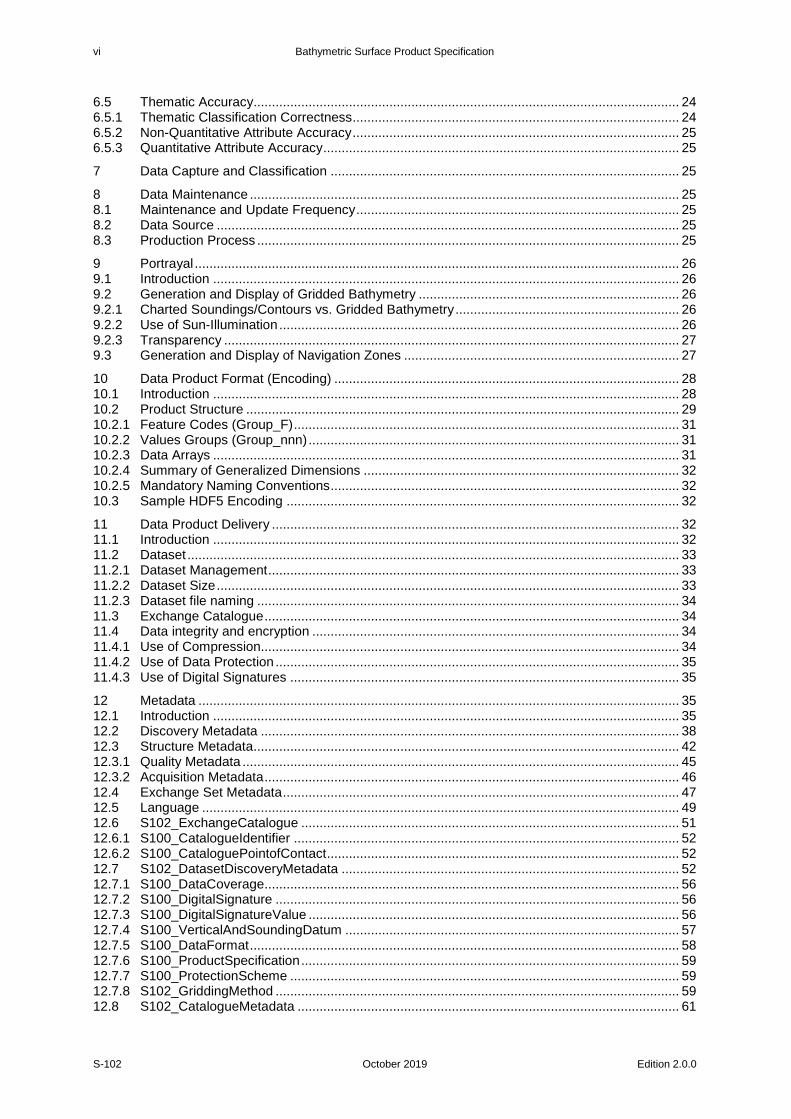
6.5 Thematic Accuracy.................................................................................................................... 24 6.5.1 Thematic Classification Correctness ......................................................................................... 24 6.5.2 Non-Quantitative Attribute Accuracy ......................................................................................... 25 6.5.3 Quantitative Attribute Accuracy ................................................................................................. 25
7 Data Capture and Classification ............................................................................................... 25
8 Data Maintenance ..................................................................................................................... 25 8.1 Maintenance and Update Frequency ........................................................................................ 25 8.2 Data Source .............................................................................................................................. 25 8.3 Production Process ................................................................................................................... 25
9 Portrayal .................................................................................................................................... 26 9.1 Introduction ............................................................................................................................... 26 9.2 Generation and Display of Gridded Bathymetry ....................................................................... 26 9.2.1 Charted Soundings/Contours vs. Gridded Bathymetry ............................................................. 26 9.2.2 Use of Sun-Illumination ............................................................................................................. 26 9.2.3 Transparency ............................................................................................................................ 27 9.3 Generation and Display of Navigation Zones ........................................................................... 27
10 Data Product Format (Encoding) .............................................................................................. 28 10.1 Introduction ............................................................................................................................... 28 10.2 Product Structure ...................................................................................................................... 29 10.2.1 Feature Codes (Group_F) ......................................................................................................... 31 10.2.2 Values Groups (Group_nnn) ..................................................................................................... 31 10.2.3 Data Arrays ............................................................................................................................... 31 10.2.4 Summary of Generalized Dimensions ...................................................................................... 32 10.2.5 Mandatory Naming Conventions ............................................................................................... 32 10.3 Sample HDF5 Encoding ........................................................................................................... 32
11 Data Product Delivery ............................................................................................................... 32 11.1 Introduction ............................................................................................................................... 32 11.2 Dataset ...................................................................................................................................... 33 11.2.1 Dataset Management ................................................................................................................ 33 11.2.2 Dataset Size .............................................................................................................................. 33 11.2.3 Dataset file naming ................................................................................................................... 34 11.3 Exchange Catalogue ................................................................................................................. 34 11.4 Data integrity and encryption .................................................................................................... 34 11.4.1 Use of Compression.................................................................................................................. 34 11.4.2 Use of Data Protection .............................................................................................................. 35 11.4.3 Use of Digital Signatures .......................................................................................................... 35
12 Metadata ................................................................................................................................... 35 12.1 Introduction ............................................................................................................................... 35 12.2 Discovery Metadata .................................................................................................................. 38 12.3 Structure Metadata.................................................................................................................... 42 12.3.1 Quality Metadata ....................................................................................................................... 45 12.3.2 Acquisition Metadata ................................................................................................................. 46 12.4 Exchange Set Metadata ............................................................................................................ 47 12.5 Language .................................................................................................................................. 49 12.6 S102_ExchangeCatalogue ....................................................................................................... 51 12.6.1 S100_CatalogueIdentifier ......................................................................................................... 52 12.6.2 S100_CataloguePointofContact ................................................................................................ 52 12.7 S102_DatasetDiscoveryMetadata ............................................................................................ 52 12.7.1 S100_DataCoverage................................................................................................................. 56 12.7.2 S100_DigitalSignature .............................................................................................................. 56 12.7.3 S100_DigitalSignatureValue ..................................................................................................... 56 12.7.4 S100_VerticalAndSoundingDatum ........................................................................................... 57 12.7.5 S100_DataFormat ..................................................................................................................... 58 12.7.6 S100_ProductSpecification ....................................................................................................... 59 12.7.7 S100_ProtectionScheme .......................................................................................................... 59 12.7.8 S102_GriddingMethod .............................................................................................................. 59 12.8 S102_CatalogueMetadata ........................................................................................................ 61
Bathymetric Surface Product Specification vii
S-102 October 2019 Edition 2.0.0
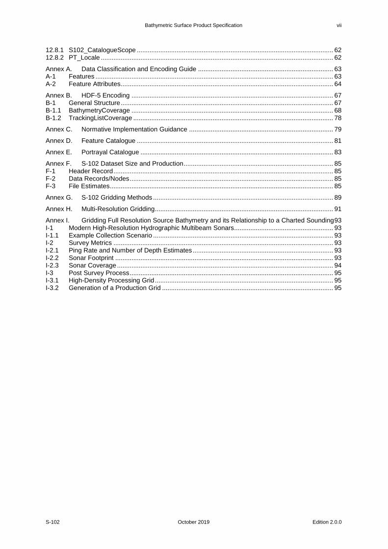
12.8.1 S102_CatalogueScope ............................................................................................................. 62 12.8.2 PT_Locale ................................................................................................................................. 62
Annex A. Data Classification and Encoding Guide ........................................................................... 63 A-1 Features .................................................................................................................................... 63 A-2 Feature Attributes ...................................................................................................................... 64
Annex B. HDF-5 Encoding ................................................................................................................ 67 B-1 General Structure ...................................................................................................................... 67 B-1.1 BathymetryCoverage ................................................................................................................ 68 B-1.2 TrackingListCoverage ............................................................................................................... 78
Annex C. Normative Implementation Guidance ................................................................................ 79
Annex D. Feature Catalogue ............................................................................................................. 81
Annex E. Portrayal Catalogue ........................................................................................................... 83
Annex F. S-102 Dataset Size and Production ................................................................................... 85 F-1 Header Record .......................................................................................................................... 85 F-2 Data Records/Nodes ................................................................................................................. 85 F-3 File Estimates ............................................................................................................................ 85
Annex G. S-102 Gridding Methods .................................................................................................... 89
Annex H. Multi-Resolution Gridding ................................................................................................... 91
Annex I. Gridding Full Resolution Source Bathymetry and its Relationship to a Charted Sounding 93 I-1 Modern High-Resolution Hydrographic Multibeam Sonars....................................................... 93 I-1.1 Example Collection Scenario .................................................................................................... 93 I-2 Survey Metrics .......................................................................................................................... 93 I-2.1 Ping Rate and Number of Depth Estimates .............................................................................. 93 I-2.2 Sonar Footprint ......................................................................................................................... 93 I-2.3 Sonar Coverage ........................................................................................................................ 94 I-3 Post Survey Process ................................................................................................................. 95 I-3.1 High-Density Processing Grid ................................................................................................... 95 I-3.2 Generation of a Production Grid ............................................................................................... 95

viii Bathymetric Surface Product Specification
S-102 October 2019 Edition 2.0.0
Page intentionally left blank
Bathymetric Surface Product Specification 1
S-102 October 2019 Edition 2.0.0
1 Overview
With the advent of electronic navigation and the technological progress of surveying systems and production capabilities, the ability to enhance maritime navigation with the portrayal of high resolution bathymetry has become a requirement. The provision and utilization of such data in a standardized format is essential to support the safe and precise navigation of marine vessels, and furthermore an important basis for many other maritime applications.
1.1 Introduction
This document describes an S-100 compliant product specification for a bathymetric surface product. Incorporating aspects of the navigation surface concept [Smith et al, 2002], an S-102 bathymetric surface product is a digital elevation model which represents the seafloor in a regular grid structure. It can be used alone or as an important element/source for future S-100 conformant ECDIS navigation. The product specification is based on the IHO S-100 framework specification and the ISO 19100 series of standards. It comprises the content model (spatial structure and metadata), encoding structure, portrayal and exchange file format for a bathymetric surface product.
1.2 References
IHO S-100 Universal Hydrographic Data Model v4.0.0, December 2018 (Encoding, Feature Catalogue)
IHO S-44 Standards for Hydrographic Surveys 5th Edition, February 2008
IHO S-4 Regulations of the IHO for International (INT) Charts and Chart Specifications of the IHO, Edition 4.8.0, October/November 2018.
IHO S-32 Hydrographic Dictionary 5th Edition, Part 1, Volume 1 (English), 1994
ISO 8601:2004 Data elements and interchange formats - Information interchange - Representation of dates and times
ISO/TS 19103:2015 Geographic information - Conceptual schema language
ISO 19111:2007 Geographic information - Spatial referencing by coordinates
ISO 19115-1:2014/Amd 1:2018 Geographic information - Metadata
ISO 19115-2:2009 Geographic information - Metadata: Extensions for imagery and gridded data
ISO 19123:2005 Geographic information - Schema for coverage geometry and functions
ISO 19129:2009 Geographic information - Imagery gridded and coverage data framework
ISO 19131:2007/Amd 1:2011 Geographic information - Data product specifications
ISO/IEC 19501:2005 Information technology - Open Distributed Processing - Unified Modelling Language Version 1.4.2
Smith, Shep M. LT; Alexander, Lee; and Armstrong, Andy, "The Navigation Surface: A New Database Approach to Creating Multiple Products from High-Density Surveys" (2002). International Hydrographic Review. http://scholars.unh.edu/ccom/976
Calder, Brian; Byrne, Shannon; Lamey, Bill; Brennan, Richard T.; Case, James D.; Fabre, David; Gallagher, Barry; Ladner, Wade R.; Moggert, Friedhelm; and Patron, Mark, "The Open Navigation Surface Project" (2005).
International Hydrographic Review. https://scholars.unh.edu/ccom/1011
2 Bathymetric Surface Product Specification
S-102 October 2019 Edition 2.0.0
1.3 Terms, definitions and abbreviations
1.3.1 Use of Language
Within this document:
“Must” indicates a mandatory requirement.
“Should” indicates an optional requirement, that is the recommended process to be followed, but is not mandatory.
“May” means “allowed to” or “could possibly” and is not mandatory.
1.3.2 Terms and Definitions
Accuracy Closeness of agreement between a test result and the accepted reference values.
NOTE: A test result can be from an observation or measurement.
Coordinate One of a sequence of n numbers designating the position of a point in N-dimensional space.
NOTE: The numbers must be qualified by units.
Coordinate Reference System Coordinate system which is related to the real world by a datum.
Coverage Feature that acts as a function to return values from its range for any direct position within its spatial, temporal, or spatiotemporal domain.
NOTE: In other words, a coverage is a feature that has multiple values for each attribute type, where each direct position within the geometric representation of the feature has a single value for each attribute type.
EXAMPLE: Examples include a digital image, polygon overlay, or digital elevation matrix
Coverage Geometry Configuration of the domain of a coverage described in terms of coordinates.
Direct Position Position described by a single set of coordinates within a coordinate reference system.
Domain Well-defined set.
NOTE: Domains are used to define the domain set and range set of attributes, operators and functions.
Depth The vertical distance from a given water level to the bottom.
Feature Abstraction of real world phenomena.
NOTE: A feature may occur as a type or an instance. Feature type or feature instance should be used when only one is meant.
Feature Attribute Characteristic of a feature.
Bathymetric Surface Product Specification 3
S-102 October 2019 Edition 2.0.0
NOTE: A feature attribute type has a name, a data type and a domain associated to it. A feature attribute instance has an attribute value taken from the value domain of the feature attribute type.
Function Rule that associates each element from a domain (source, or domain of the function) to a unique element in another domain (target, co-domain, or range).
NOTE: The range is defined by another domain.
Geometric Object Spatial object representing a set of direct positions
NOTE: A geometric object consists of a geometric primitive, a collection of geometric primitives, or a geometric complex treated as a single entity. A geometric object may be the spatial characteristics of an object such as a feature or a significant part of a feature.
Grid Network composed of two or more sets of curves in which the members of each set intersect the members of the other sets in a systematic way.
NOTE: The curves partition a space into grid cells.
Grid Point Point located at the intersection of two or more curves in a grid.
LIDAR An optical remote sensing technique that uses a laser pulse to determine distance.
NOTE: LIDAR may be used to determine depth in shallow water areas.
Navigation Surface A coverage representing the bathymetry and associated uncertainty with the methods by which those objects can be manipulated, combined and used for a number of tasks, certified for safety of navigation
Range <coverage> Set of values associated by a function with the elements of the spatiotemporal domain of a coverage.
Record Finite, named collection of related items (objects or values).
NOTE: Logically, a record is a set of pairs <name, item >.
Rectified Grid Grid for which there is a linear relationship between the grid coordinates and the coordinates of an external coordinate reference system.
NOTE: If the coordinate reference system is related to the earth by a datum, the grid is a georectified grid.
Referenceable Grid Grid associated with a transformation that can be used to convert grid coordinate values to values of coordinates referenced to an external coordinate reference system.
SONAR A technique that uses sound propagation through water to determine distance, primarily depth measurement.

4 Bathymetric Surface Product Specification
S-102 October 2019 Edition 2.0.0
Spatiotemporal Domain <coverage> Domain composed of geometric objects described in terms of spatial and/or temporal coordinates.
NOTE: The spatiotemporal domain of a continuous coverage consists of a set of direct positions defined in relation to a collection of geometric objects.
Surface Connected 2-dimensional geometric primitive, representing the continuous image of a region of a plane.
NOTE: The boundary of a surface is the set of oriented, closed curves that delineate the limits of the surface.
Tiling Scheme A discrete grid coverage that is used to partition data into discrete edge matched sets called tiles.
Uncertainty The interval (about a given value) that will contain the true value of the measurement at a specific confidence level.
NOTE: Errors exist and are the differences between the measured value and the true value. Since the true value is never known it follows that the error itself cannot be known. Uncertainty is a statistical assessment of the likely magnitude of this error.
Vector Quantity having direction as well as magnitude.
NOTE: A directed line segment represents a vector if the length and direction of the line segment are equal to the magnitude and direction of the vector. The term vector data refers to data that represents the spatial configuration of features as a set of directed line segments.
1.3.3 Abbreviations
This product specification adopts the following convention for presentation purposes:
API Application Programming Interface
DS Digital Signature
ECDIS Electronic Chart Display Information System
ECS Electronic Chart System
ENC Electronic Navigational Chart
GML Geography Markup Language
IHO International Hydrographic Organization
ISO International Standards Organization
LIDAR Light Detection and Ranging
NS Navigation Surface
ONS Open Navigation Surface
PK Public Key
Bathymetric Surface Product Specification 5
S-102 October 2019 Edition 2.0.0
SA Signature Authority
SK Secret Key
SONAR Sound Navigation and Ranging
UML Universal Modelling Language
1.4 S-102 General Data Product Description
Title: Bathymetric Surface Product Specification
Abstract: This document is a Product Specification for a bathymetric surface which may be
used alone or as an important element/source for future S-100 conformant ECDIS navigation. The product is defined as a data set with different coverages. This Product Specification includes a content model and separate encodings.
Content: The Product Specification defines all requirements to which S-102 bathymetric data
products must conform. Specifically, it defines the data product content in terms of features and attributes within the feature catalogue. The display of features is defined by the symbols and rule sets contained in the portrayal catalogue. The Data Classification and Encoding Guide (DCEG) provides guidance on how data product content must be captured. Annex A, in addition to Annex C, will provide implementation guidance for developers.
Spatial Extent:
Description: Areas specific to marine navigation.
East Bounding Longitude: 180°
West Bounding Longitude: -180°
North Bounding Latitude: 90°
South Bounding Latitude: -90°
Specific Purpose: The primary purpose of the Bathymetric Surface Product is to provide high
resolution bathymetry in gridded form in support of safety of navigation. A Bathymetric Surface Product may exist anywhere in the maritime domain. There are no limitations to its extent. Portrayal of S-102 bathymetry with other S-100 compliant products are intended to support safe passage, precise berthing and mooring, as well as route planning of marine vessels. The secondary purpose of a bathymetric surface product is to provide high resolution bathymetric data for other maritime applications.
1.5 Product Specification Metadata
This information uniquely identifies this Product Specification and provides information about its creation and maintenance. For further information on dataset metadata, see Clause 12 - Metadata.
Title: Bathymetric Surface Product Specification
S-100 Version: 4.0.0
S-102 Version: 2.0.0
6 Bathymetric Surface Product Specification
S-102 October 2019 Edition 2.0.0
Date: October 2019
Language: English
Classification: Unclassified
Contact: International Hydrographic Bureau
4 Quai Antoine 1er B.P. 445 MC 98011 MONACO CEDEX Telephone: +377 93 10 81 00 Fax: + 377 93 10 81 40 Email: [email protected]
URL: www.iho.int
Identifier: IHO:S100:S102:2:0:0
Maintenance: Changes to the Product Specification S-201 are coordinated by the IHO S-100
Working Group (S-100WG), and must be made available via the IHO web site. Maintenance of the Product Specification must conform to IHO Resolution 2/2007, as amended.
1.6 IHO Product Specification Maintenance
1.6.1 Introduction
Changes to S-102 will be released by the IHO as a New Edition, revision, or clarification.
1.6.2 New Edition
New Editions of S-102 introduce significant changes. New Editions enable new concepts, such as the ability to support new functions or applications, or the introduction of new constructs or data types. New Editions are likely to have a significant impact on either existing users or future users of S-102.
1.6.3 Revisions
Revisions are defined as substantive semantic changes to S-102. Typically, revisions will change S-102 to correct factual errors; introduce necessary changes that have become evident as a result of practical experience or changing circumstances. A revision must not be classified as a clarification. Revisions could have an impact on either existing users or future users of S-102. All cumulative clarifications must be included with the release of approved corrections revisions.
Changes in a revision are minor and ensure backward compatibility with the previous versions within the same Edition. Newer revisions, for example, introduce new features and attributes. Within the same Edition, a dataset of one version could always be processed with a later version of the feature and portrayal catalogues.
In most cases a new feature or portrayal catalogue will result in a revision of S-102.
1.6.4 Clarification
Clarifications are non-substantive changes to S-102. Typically, clarifications: remove ambiguity; correct grammatical and spelling errors; amend or update cross references; insert improved graphics in spelling, punctuation and grammar. A clarification must not cause any substantive semantic change to S-102.
Bathymetric Surface Product Specification 7
S-102 October 2019 Edition 2.0.0
Changes in a clarification are minor and ensure backward compatibility with the previous versions within the same Edition. Within the same Edition, a dataset of one clarification version could always be processed with a later version of the feature and portrayal catalogues, and a portrayal catalogue can always rely on earlier versions of the feature catalogues.
1.6.5 Version Numbers
The associated version control numbering to identify changes (n) to S-102 must be as follows:
New Editions denoted as n.0.0
Revisions denoted as n.n.0
Clarifications denoted as n.n.n
2 Specification Scope
This product specification defines only one general scope which applies to all its sections.
Scope Identification: GeneralScope
3 Data Product Identification
Title: Bathymetric Surface
Abstract: The Bathymetric Surface Product consists of a set of values organized to form a regular grid coverage, with associated metadata, for an area of the sea, river, lake or other navigable water. Final grid coverage includes a depth value and associated uncertainty estimate for each location in the matrix. In addition, a discrete point set called a "tracking list" is included. The tracking list contains locations where a hydrographer or the data producer overrode a grid matrix value to deliberately bias the final surface for safety of navigation. That is, the data set can carry both the corrected depth information to support the safe navigation of marine vessels as well as the original measured depth value to support scientific purposes.
Topic Category: Main topics for the product, as according to ISO/IEC 19115-1 MD_TopicCategoryCode:
006 – elevation
014 – oceans
012 – inlandWaters
Geographic Description: Areas specific to marine navigation.
Spatial Resolution:
The spatial resolution, or the spatial dimension on the earth covered by the size of a grid matrix cell (nominal ground sample distance), varies according to the model adopted by
8 Bathymetric Surface Product Specification
S-102 October 2019 Edition 2.0.0
(the producer hydrographic office).
Purpose:
The primary purpose of the bathymetric surface product is to provide high resolution bathymetry in gridded form in support of safety of navigation. The secondary purpose is to provide high resolution bathymetry for other maritime applications.
Language:
English (Mandatory), other (Optional)
Classification: Data can be classified as one of the following:
1) Unclassified;
2) Restricted;
3) Confidential; 4) Secret; 5) Top Secret; 6) Sensitive but unclassified; 7) For official use only; 8) Protected; or 9) Limited distribution.
Spatial Representation Type: Type of spatial representation for the product, as defined by the
ISO 19115 MD_SpatialRepresentationTypeCode: 002 - grid.
Point of Contact: Producing Agency
4 Data Content and structure
4.1 Introduction
The Bathymetric Surface Product incorporates aspects of the Navigation Surface concept where in addition to estimation of depth, an optional estimate of the uncertainty associated with the depth can be computed and preserved. To make the system suitable to support safety of navigation applications, there is a means to over-ride any automatically constructed depth estimates with ‘Hydrographer Privilege, (essentially, a means to specify directly the depth determined by a human observer as being the most significant in the area - irrespective of any statistical evidence to the contrary). The original grid values that are replaced by the hydrographer are preserved in the tracking list so that they can be restored if required.
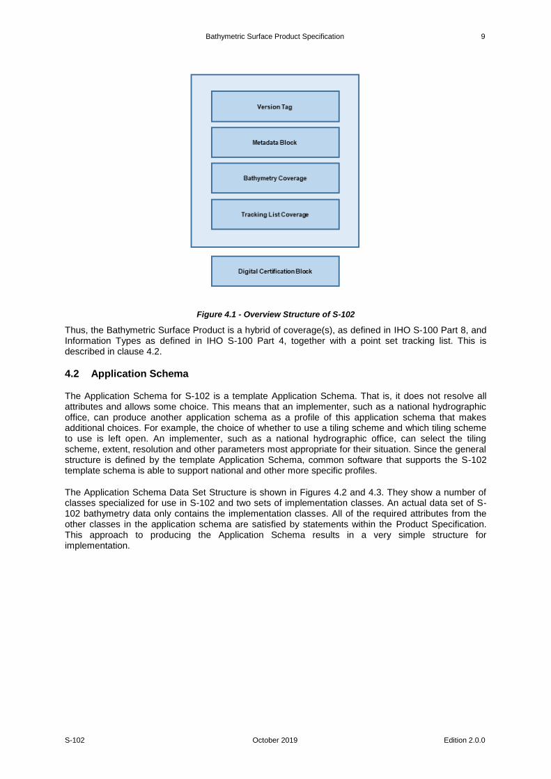
Figure 4.1 below shows a high-level overview of the structure of S-102. It shows that the Bathymetric Surface Product consists of a set of data comprising the HDF5 datasets plus a Digital Certification Block. The Digital Certification Block is mandatory when the data product is produced for navigational purposes so that the user can trace whether the data has been certified. The HDF5 file consists of metadata (spatial, feature and discovery), collocated coverages consisting of depth and uncertainty values, and a tracking list of overridden nodes. S-102 uses the S-100 Data Protection Scheme to ensure certification and authentication.
Bathymetric Surface Product Specification 9
S-102 October 2019 Edition 2.0.0
Figure 4.1 - Overview Structure of S-102
Thus, the Bathymetric Surface Product is a hybrid of coverage(s), as defined in IHO S-100 Part 8, and Information Types as defined in IHO S-100 Part 4, together with a point set tracking list. This is described in clause 4.2.
4.2 Application Schema
The Application Schema for S-102 is a template Application Schema. That is, it does not resolve all attributes and allows some choice. This means that an implementer, such as a national hydrographic office, can produce another application schema as a profile of this application schema that makes additional choices. For example, the choice of whether to use a tiling scheme and which tiling scheme to use is left open. An implementer, such as a national hydrographic office, can select the tiling scheme, extent, resolution and other parameters most appropriate for their situation. Since the general structure is defined by the template Application Schema, common software that supports the S-102 template schema is able to support national and other more specific profiles.
The Application Schema Data Set Structure is shown in Figures 4.2 and 4.3. They show a number of classes specialized for use in S-102 and two sets of implementation classes. An actual data set of S-102 bathymetry data only contains the implementation classes. All of the required attributes from the other classes in the application schema are satisfied by statements within the Product Specification. This approach to producing the Application Schema
results in a very simple structure for
implementation.
10 Bathymetric Surface Product Specification
S-102 October 2019 Edition 2.0.0
Figure 4.2 - Data Set Structure of S-102
The model in Figure 4.2 states that:
An S-102 data set (S102_DataSet), which is inherited from S100_DataSet, references an S-102 Image and Gridded Data Collection (S102_IGCollection). The relationship allows a 1 to many (1..*) multiplicity which means that there may be multiple instances of S-102 data collections. Each collection may or may not correspond to a tiling scheme, and each S102 Dataset would correspond to a single tile. The S-102 discovery metadata class (S102_DiscoveryMetadata) describes the metadata entities required for the identification of the entire data set. The required discovery metadata is implemented through the S102_DSMetadataBlock class.
An instance of an S-102 Image and Gridded Data Collection (S102_IGCollection) which is a subtype of S100_IGCollection, is described by a set of S-102 Collection Metadata (S102_CollectionMetadata). This relationship is 1 to 1 meaning that there is one set of collection metadata for each instance of S102_IGCollection. There is a large choice of metadata that may be used in a S-100 compliant data product. Only a small amount of this metadata is mandated by ISO 19115 for discovery. The choice of metadata is discussed in clause 9.2.5. Much of the metadata can be resolved as part of the product specification. Only that metadata that varies IG_collection item to item needs be included in the S102_MetadataBlock implementation class.
An S-102 Image and Gridded Data Collection also optionally makes reference to a tiling scheme.
This is discussed further in clause 4.2.2.
Bathymetric Surface Product Specification 11
S-102 October 2019 Edition 2.0.0
Figure 4.3 - Coverage Structure of S-102
The model in Figure 4.3 depicts two coverage types in this application schema:
The first coverage type is a discrete Regular Grid Coverage called S102_DepthCoverage which inherits from (S100_GridCoverage). Many of the parameters of the coverage are described in the product specification. The implementation classes are co-registered, co-geospatially located datasets.
The second coverage type is a discrete point set coverage called S102_CorrectionCoverage. The S102_CorrectionCoverage consists of a set of discrete points that correspond to locations which had corrective overrides applied. (I.E. A hydrographer may explicitly specify depth values at specific points to deliberately ensure safety of navigation.) The conflation function simply replaces specific values from the S102_BathymetryValues grid values matrix with the corresponding overriding values.
4.2.1 Application Schema Implementation Classes
The implementation classes for the template application schema are shown in Figure 4.4. The attributes are shown for the coverage related classes together with the attribute classes.
In order to simplify the implementation a number of defaults are assumed for S-102. These defaults simplify implementation and help simplify interaction with the Navigation Surface implementation from the Open Navigation Surface Working Group and other bathymetric gridded types. In the following sub clauses, the default values are emphasized so that they do not need to be encoded when generating an encoding of the implementation classes. However, if specified they must assume the stated values unless other options are stated.
12 Bathymetric Surface Product Specification
S-102 October 2019 Edition 2.0.0
Figure 4.4 - Implementation of Classes of S-102
4.2.1.1 Implementation Classes Description
4.2.1.1.1 BathymetryCoverage
4.2.1.1.1.1 BathymetryCoverage semantics
The class BathymetryCoverage has the attributes minimumDepth, maximumDepth, minimumUncertainty, and maximumUncertainty which bound the depth attribute and the uncertainty attribute from the S102_BathymetryValues record. BathymetryCoverage also contains the attributes minimumDisplayScale and maximumDisplayScale which define the appropriate scale range for the coverage. BathymetryCoverage additionally contains the inherited attributes origin, offsetVectors, dimension, axisName, extent, sequenceRule, and startSequence from S100_Grid and CV_Grid.
The origin is a position in a specified coordinate reference system, and a set of offset vectors specify the direction and distance between the grid lines. It also contains the additional geometric characteristics of a rectified grid.
4.2.1.1.1.2 maximumDisplayScale
The smaller value of the ratio of the linear dimensions of the features of a dataset presented in the display and the actual dimensions of the features represented (smallest scale) of the scale range of the dataset. A list of display scale ranges is available in Table 11.1, 1st column.
Bathymetric Surface Product Specification 13
S-102 October 2019 Edition 2.0.0
4.2.1.1.1.3 minimumDepth
The attribute minimumDepth has the value type Real and describes the lower bound of the depth estimate for all the depth values in S102_BathymetryValues record. This attribute is required. There is no default.
4.2.1.1.1.4 maximumDepth
The attribute maximumDepth has the value type Real and describes the upper bound of the depth estimate for all the depth values in S102_BathymetryValues record. This attribute is required. There is no default.
4.2.1.1.1.5 minimumDisplayScale
The larger value of the ratio of the linear dimensions of the features of a dataset presented in the display and the actual dimensions of the features represented (largest scale) of the scale range of the dataset. A list of display scale ranges is available in Figure 11.1, 1st column.
4.2.1.1.1.6 minimumUncertainty
The attribute minimumUncertainty has the value type Real and describes the lower bound of the uncertainty of the depth estimate for all the depth values in S102_BathymetryValues record. This attribute is required. There is no default.
4.2.1.1.1.7 maximumUncertainty
The attribute maximumUncertainty has the value type Real and describes the upper bound of the uncertainty of the depth estimate for all the depth values in S102_BathymetryValues record. This attribute is required. There is no default.
4.2.1.1.1.8 origin
The attribute origin has the value class DirectPosition which is a position that shall locate the origin of the rectified grid in the coordinate reference system. This attribute is required. There is no default.
4.2.1.1.1.9 offsetVectors
The attribute offsetVectors has the value class Sequence<Vector> that shall be a sequence of offset vector elements that determine the grid spacing in each direction. The data type Vector is specified in ISO/TS 19103. This attribute is required. There is no default.
4.2.1.1.1.10 dimension
The attribute dimension has the value class Integer that shall identify the dimensionality of the grid. The value of the grid dimension in this product specification is 2. This value is fixed in this Product Specification and does not need to be encoded.
4.2.1.1.1.11 axisNames
The attribute axisNames has the value class Sequence<CharacterString> that shall be used to assign names to the grid axis. The grid axis names shall be "Latitude" and "Longitude" for unprojected data sets or “Northing” and “Easting” in a projected space.
4.2.1.1.1.12 extent
The attribute extent has the value class CV_GridEnvelope that shall contain the extent of the spatial domain of the coverage. It uses the value class CV_GridEnvelope which provides the grid coordinate values for the diametrically opposed corners of the grid. The default is that this value is derived from the bounding box for the data set or tile in a multi tile data set.
4.2.1.1.1.13 sequencingRule
The attribute sequencingRule has the value class CV_SequenceRule that shall describe how the grid points are ordered for association to the elements of the sequence values. The default value is "Linear". No other options are allowed.
14 Bathymetric Surface Product Specification
S-102 October 2019 Edition 2.0.0
4.2.1.1.1.14 startSequence
The attribute startSequence has the value class CV_GridCoordinate that shall identify the grid point to be associated with the first record in the values sequence. The default value is the lower left corner of the grid. No other options are allowed.
4.2.1.1.2 S102_BathymetryValues
4.2.1.1.2.1 S102_BathymetryValues semantics
The class S102_BathymetryValues is related to BathymetryCoverage by a composition relationship in which an ordered sequence of depth values provide data values for each grid cell. The class S102_BathymetryValues inherits from S100_Grid.
4.2.1.1.2.2 values
The attribute values has the value type S102_BathymetryValueRecord which is a sequence of value items that shall assign values to the grid points. There are two attributes in the bathymetry value record, depth and uncertainty in the S102_BathymetryValues class. The definition for the depth is defined by the depthCorrectionType attribute in the S102_DataIdentification class. The definition of the type of data in the values record is defined by the verticalUncertaintyType attribute in the S102_DataIdentification class.
4.2.1.1.3 DirectPosition
4.2.1.1.3.1 DirectPosition semantics
The class DirectPosition hold the coordinates for a position within some coordinate reference system.
4.2.1.1.3.2 coordinate
The attribute coordinate is a sequence of Numbers that hold the coordinate of this position in the specified reference system.
4.2.1.1.3.3 dimension
The attribute dimension is a derived attribute that describes the length of coordinate.
4.2.1.1.4 CV_GridEnvelope
4.2.1.1.4.1 CV_GridEnvelope semantics
The class CV_GridEnvelope provides the grid coordinate values for the diametrically opposed corners of an envelope that bounds a grid. It has two attributes.
4.2.1.1.4.2 low
The attribute low shall be the minimal coordinate values for all grid points within the envelope. For this specification this represents the Southwestern coordinate.
4.2.1.1.4.3 high
The attribute high shall be the maximal coordinate values for all grid points within the envelope. For this specification this represents the Northeastern coordinate.
4.2.1.1.5 CV_GridCoordinate
4.2.1.1.5.1 CV_GridCoordinate semantics
The class CV_GridCoordinate is a data type for holding the grid coordinates of a CV_GridPoint.
4.2.1.1.5.2 coordValues
The attribute coordValues has the value class Sequence<Integer> that shall hold one integer value for
each dimension of the grid. The ordering of these coordinate values shall be the same as that of the elements of axisNames. The value of a single coordinate shall be the number of offsets from the origin of the grid in the direction of a specific axis.
Bathymetric Surface Product Specification 15
S-102 October 2019 Edition 2.0.0
4.2.1.1.6 CV_SequenceRule
4.2.1.1.6.1 CV_SequenceRule semantics
The class CV_SequenceRule contains information for mapping grid coordinates to a position within the sequence of records of feature attribute values. It has two attributes.
4.2.1.1.6.2 type
The attribute type shall identify the type of sequencing method that shall be used. A code list of scan types is provided in S-100 Part 8. Only the value ―linear‖ shall be used in S-102, which describes scanning row by row by column.
4.2.1.1.7 scanDirection
The attribute scanDirection has the value class Sequence<CharacterString> a list of axis names that indicates the order in which grid points shall be mapped to position within the sequence of records of feature attribute values. The scan direction for all layers in S-102 is "Longitude" and "Latitude" or west to east, then south to north.
4.2.1.1.8 TrackingListCoverage
4.2.1.1.8.1 TrackingListCoverage semantics
The class TrackingListCoverage has the attributes domainExtent, rangeType, CommonPointRule and metadata inherited from S100_PointCoverage. The TrackingListCoverage is a discrete point coverage which is used to track overridden nodes in the BathymetryCoverage by allowing a hydrographer to apply a bias for safety of navigation. The attribute metadata provides one method of linking the metadata to the coverage inherited from S-100, however it is not required in S-102 because there is no need for specific metadata at the feature (class) level. The attribute commonPointRule is also not required because the value has been established for the whole of the S-102 data product to be "average". The attribute rangeType takes on the value class RecordType. This is modelled by the composition of multiple instances of S102_TrackingListValues. Therefore, only the attribute domainExtent is required, and it has a default value.
4.2.1.1.8.2 domainExtent
The attribute domainExtent has the value class EX_GeographicExtent which describes the spatial boundaries of the tracking list elements within the bounds established by CV_GridEnvelope for the BathymetryCoverage. The default is the bounds established by the attribute CV_GridEnvelope.
4.2.1.1.9 S102_TrackingListValues
4.2.1.1.9.1 S102_TrackingListValues semantics
The class S102_TrackingListValues has the attributes trackCode and listSeries, and the attributes geometry, and value inherited from S100_VertexPoint and CV_GeometryValuePair. The tracking list is a discrete coverage used to furnish the set of values that were overridden in the S102_BathymetryValues class. To assure alignment of tracking list values with the grid cells in the bathymetry coverage grid, the reference system for the tracking list is the bathymetry coverage regular grid.
The trackCode value and the listSeries value provide context for the override a value from the bathymetry coverage. The trackCode value is a text string that describes the reason for the override.
4.2.1.1.9.2 trackCode
The optional attribute trackCode has the value type CharacterString which may contain a text string describing the reason for the override of the corresponding depth and uncertainty values in the bathymetry coverage. This is a user definable field with values defined in the lineage metadata.
16 Bathymetric Surface Product Specification
S-102 October 2019 Edition 2.0.0
4.2.1.1.9.3 listSeries
The attribute listSeries has the value type Integer which contains an index number into a list of metadata elements describing the reason for the override of the corresponding depth and uncertainty values in the bathymetry coverage.
4.2.1.1.9.4 geometry
The attribute geometry has the value class GM_Point which is a position that shall locate the tracking list value. When the TrackingListCoverage discrete coverage and the BathymetryCoverage are conflated the values that are overridden in the sequence of the attribute S102_BathymetryValues are located by position. The value class is GM_Point which is the x, y grid post coordinate of the coverage.
4.2.1.1.9.5 value
The attribute value has the value class Record which is a sequence of value items that shall assign values to the discrete grid point. There are two values in each record in the S102_ TrackingListValues class. These are the depth and the uncertainty values that were overridden in corresponding grid coverages.
4.2.1.1.10 GM_Point
4.2.1.1.10.1 GM_Point semantics
The class GM_Point is taken from ISO 19107 and is the basic data type for a geometric object consisting of one and only one point. It has one attribute.
4.2.1.1.10.2 position
The attribute position is derived from DirectPosition for the geometry primitive GM_Point. To assure alignment of tracking list values with the grid points in the bathymetry coverage grid, the reference system for the tracking list is the bathymetry coverage regular grid. This means that the position attribute corresponds to a grid point. For a uniform regular grid this is the row and column of the grid point position.
4.2.1.1.11 EX_GeographicExtent
4.2.1.1.11.1 EX_GeographicExtent semantics
The class EX_GeographicExtent is a metadata class from ISO 19115. It is a component of the metaclass EX_Extent. The use of EX_GeographicExtent is optional. When used it describes the spatial boundaries of the Tracking List elements within the bounds established by CV_GridEnvelope for the BathymetryCoverage. That is, the tracking list may carry information corresponding only to a portion of the spatial extent covered by the BathymetryCoverage. There is one attribute and one subtype.
4.2.1.1.11.2 extentTypeCode
The attribute extentTypeCode is a Boolean value. It is used to indicate whether the bounding polygon/box encompasses an area covered by the data or an area where data is not present. In S-102 it is set to 1.
4.2.1.1.12 EX_GeographicBoundingBox
4.2.1.1.12.1 EX_GeographicBoundingBox semantics
The class EX_GeographicBoundingBox is a metadata class from ISO 19115. It is a subtype of the abstract class EX_GeographicExtent. It defines a bounding box used to indicate the spatial boundaries of the tracking list elements within the bounds established by CV_GridEnvelope for the BathymetryCoverage. It has four attributes.
4.2.1.1.12.2 westBoundLongitude
The attribute westBoundLongitude is a coordinate value providing the west bound longitude for the bound.
Bathymetric Surface Product Specification 17
S-102 October 2019 Edition 2.0.0
4.2.1.1.12.3 eastBoundLongitude
The attribute eastBoundLongitude is a coordinate value providing the east bound longitude for the bound.
4.2.1.1.12.4 southBoundLatitude
The attribute southBoundLatitude is a coordinate value providing the south bound longitude for the bound.
4.2.1.1.12.5 northBoundLatitude
The attribute northBoundLatitude is a coordinate value providing the north bound longitude for the bound.
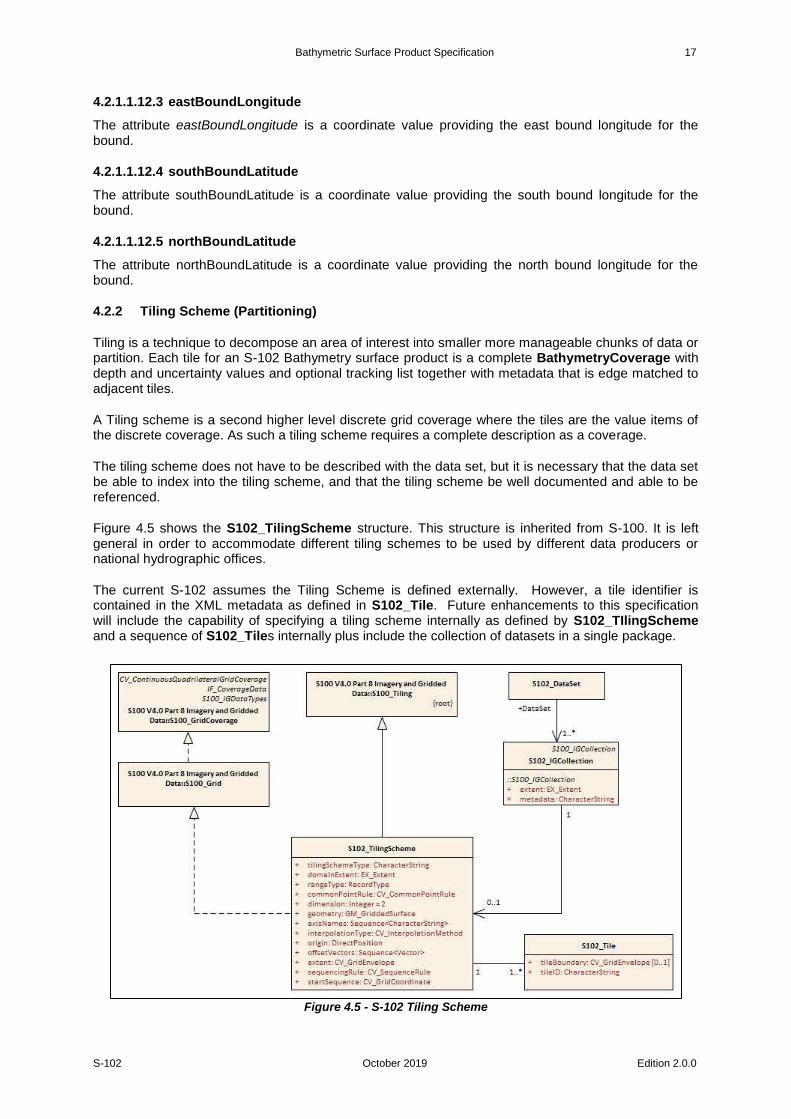
4.2.2 Tiling Scheme (Partitioning)
Tiling is a technique to decompose an area of interest into smaller more manageable chunks of data or partition. Each tile for an S-102 Bathymetry surface product is a complete BathymetryCoverage with depth and uncertainty values and optional tracking list together with metadata that is edge matched to adjacent tiles.
A Tiling scheme is a second higher level discrete grid coverage where the tiles are the value items of the discrete coverage. As such a tiling scheme requires a complete description as a coverage.
The tiling scheme does not have to be described with the data set, but it is necessary that the data set be able to index into the tiling scheme, and that the tiling scheme be well documented and able to be referenced.
Figure 4.5 shows the S102_TilingScheme structure. This structure is inherited from S-100. It is left general in order to accommodate different tiling schemes to be used by different data producers or national hydrographic offices.
The current S-102 assumes the Tiling Scheme is defined externally. However, a tile identifier is contained in the XML metadata as defined in S102_Tile. Future enhancements to this specification will include the capability of specifying a tiling scheme internally as defined by S102_TIlingScheme and a sequence of S102_Tiles internally plus include the collection of datasets in a single package.
Figure 4.5 - S-102 Tiling Scheme
18 Bathymetric Surface Product Specification
S-102 October 2019 Edition 2.0.0
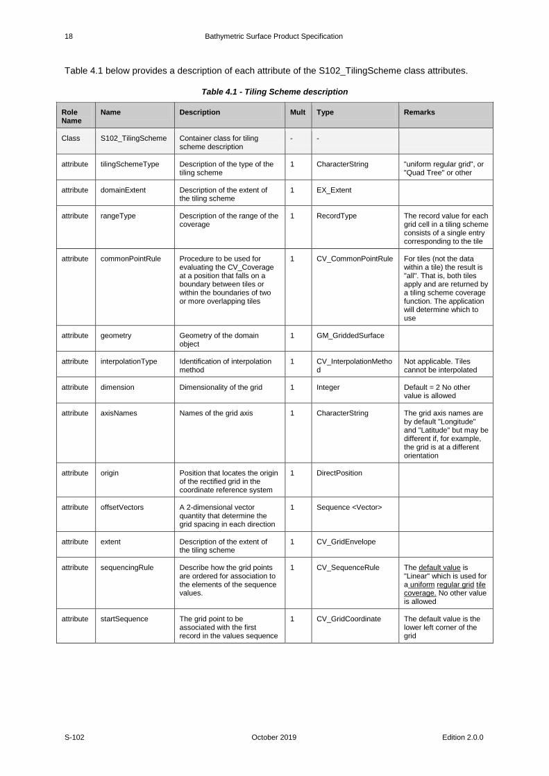
Table 4.1 below provides a description of each attribute of the S102_TilingScheme class attributes.
Table 4.1 - Tiling Scheme description
Role Name
Name Description Mult Type Remarks
Class S102_TilingScheme Container class for tiling scheme description
- -
attribute tilingSchemeType Description of the type of the tiling scheme
1 CharacterString "uniform regular grid", or "Quad Tree" or other
attribute domainExtent Description of the extent of the tiling scheme
1 EX_Extent
attribute rangeType Description of the range of the coverage
1 RecordType The record value for each grid cell in a tiling scheme consists of a single entry corresponding to the tile
attribute commonPointRule Procedure to be used for evaluating the CV_Coverage at a position that falls on a boundary between tiles or within the boundaries of two or more overlapping tiles
1 CV_CommonPointRule For tiles (not the data within a tile) the result is "all". That is, both tiles apply and are returned by a tiling scheme coverage function. The application will determine which to use
attribute geometry Geometry of the domain object
1 GM_GriddedSurface
attribute interpolationType Identification of interpolation method
1 CV_InterpolationMethod
Not applicable. Tiles cannot be interpolated
attribute dimension Dimensionality of the grid 1 Integer Default = 2 No other value is allowed
attribute axisNames Names of the grid axis 1 CharacterString The grid axis names are by default "Longitude" and "Latitude" but may be different if, for example, the grid is at a different orientation
attribute origin Position that locates the origin of the rectified grid in the coordinate reference system
1 DirectPosition
attribute offsetVectors A 2-dimensional vector quantity that determine the grid spacing in each direction
1 Sequence <Vector>
attribute extent Description of the extent of the tiling scheme
1 CV_GridEnvelope
attribute sequencingRule Describe how the grid points are ordered for association to the elements of the sequence values.
1 CV_SequenceRule The default value is "Linear" which is used for a uniform regular grid tile coverage. No other value is allowed
attribute startSequence The grid point to be associated with the first record in the values sequence
1 CV_GridCoordinate The default value is the lower left corner of the grid
Bathymetric Surface Product Specification 19
S-102 October 2019 Edition 2.0.0
4.3 Feature Catalogue
4.3.1 Introduction
The S-102 Feature Catalogue describes the feature types, information types, attributes, attribute values, associations and roles which may be used in the product.
The S-102 Feature Catalogue is available in an XML document which conforms to the S-100 XML Feature Catalogue Schema and can be downloaded from the IHO website.
Note, for Imagery and Gridded Data, coverage is a type of feature so a product specification may not contain a “catalogue” with the exception of the environmental parameter the dataset models. Therefore, much of this clause may be irrelevant.
4.3.2 Feature Types
S-102 is a coverage feature product. There are two coverages defined in this specification: BathymetryCoverage and TrackingListCoverage. BathymetryCoverage implements S102_DepthCoverage and includes S102_BathymetryValues. The second coverage, TrackingListCoverage implements S102_CorrectionCoverage, and includes S102_TrackingListValues. The S102_CorrectionCoverage is a discrete point set coverage.
4.3.2.1 Geographic
Geographic (geo) feature types form the principle content of the dataset and are fully defined by their associated attributes and information types. In S-102, BathymetryCoverage has been registered as a geographic feature type.
4.3.2.2 Meta
The only meta feature within an S-102 dataset is the tracking list. The tracking list is a simple list of nodes that have been modified to account for hydrographer over-rides of the basic surface definition (for example as originally computed by an algorithmic method). Each record within the list contains the original depth value (referenced to the associated node within the surface) and information about the override that occurred. The tracking list dataset and corresponding information contained in the metadata exist to provide an audit trail record of changes made to the data by manual intervention.
4.3.3 Feature Relationship
A feature relationship links instances of one feature type with instances of the same or a different feature type. There are three common types of feature relationship: Association, Aggregation and Composition.
S-102 uses only one type of feature relationship: Association.
4.3.3.1 Association
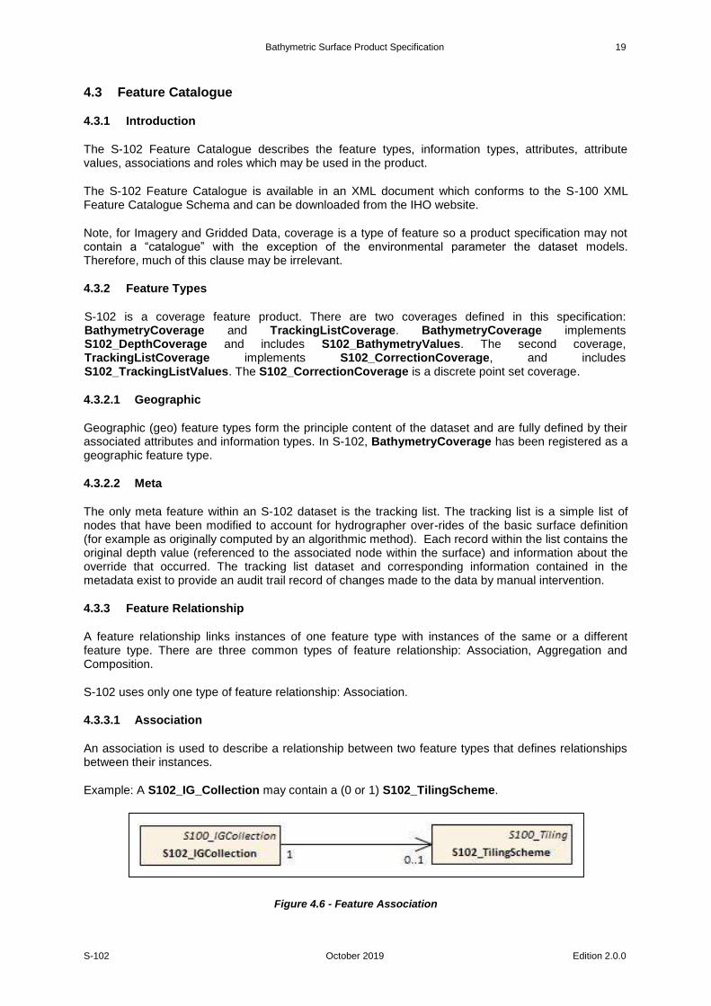
An association is used to describe a relationship between two feature types that defines relationships between their instances.
Example: A S102_IG_Collection may contain a (0 or 1) S102_TilingScheme.
Figure 4.6 - Feature Association
20 Bathymetric Surface Product Specification
S-102 October 2019 Edition 2.0.0
4.3.4 Attributes
4.3.4.1 Simple Attributes
Table 4.2 - S-102 Simple Attributes
Type Definition
Enumeration A fixed list of valid identifiers of named literal values
Boolean A value representing binary logic. The value can be either True or False. The
default state for Boolean type attributes (i.e. where the attribute is not populated
for the feature) is False
Real A signed Real (floating point) number consisting of a mantissa and an exponent
Integer A signed integer number. The representation of an integer is encapsulation and
usage dependent
CharacterString An arbitrary-length sequence of characters including accents and special
characters from a repertoire of one of the adopted character sets
Date and Time A DateTime is a combination of a date and a time type. Character encoding of a DateTime must follow ISO 8601:2004
EXAMPLE 19850412T101530
In S-102, depth and uncertainty have been registered as simple attributes, type <real>.
4.3.4.2 Complex Attributes
In S-102 there are currently no complex attributes defined.
4.4 Dataset Types
4.4.1 Introduction
Bathymetric Surface datasets are represented as a discrete array of points contained in a regular grid. The general structure for a regular grid is defined in IHO S-100 Part 8.
4.4.2 Regular Grid
4.4.2.1 S-102 Coverages
The major components of the Bathymetric Surface product are the BathymetryCoverage and the TrackingListCoverage. The BathymetryCoverage contains depth and, optionally, uncertainty. The general structure of each is defined in IHO S-100 Part 8 as a georectified grid. Spatial metadata parameters are defined in S102_StructureMetadataBlock. Furthermore, the two values are co-located within the BathymetryCoverage. Each layer contains a two-dimensional matrix organized in row major order, and starting from the south-western most data point, where each value is defined to be at an exactly specified geographic point (or grid node).
The units of the depth values are in metres, and the sign convention is for z to be positive for values above the vertical datum. The reference vertical datum for the surface is one of the mandatory Metadata items. This sign convention follows directly from the right-hand coordinate system definition to which the standard adheres.
The unknown state for depth is defined to be 1,000,000.0 (1.0e6).
The uncertainty values are expressed as positive quantities at a node. As detailed in clause 12.2 the uncertainty grid supports multiple definitions of vertical uncertainty. This allows grids to span the expected range of data products from raw, full resolution grid to final compiled product. For example, a
Bathymetric Surface Product Specification 21
S-102 October 2019 Edition 2.0.0
grid at the stage of final survey data processing should contain uncertainty information germane to the survey data itself and intended to be used for information compilation. A recipient of an S-102 file can refer to the uncertainty definition in the Metadata to gain an understanding of how the uncertainty was computed.
The undetermined state for uncertainty is defined to be 1,000,000.0 (1.0e6).
4.4.2.2 Extensions
The Bathymetric Surface Product Specification is extensible. This includes both extensions to the content model and to the encodings supporting the content model. Extensions are optional coverages and not required for a file to be qualified nor do they invalidate a compliant product. Additional layers of information not related to the bathymetric scope of this product specification should be defined in separate S.100 and S.10x compliant layers.
4.5 Multiple Datasets
In order to facilitate the efficient processing of S-102 data, the geographic coverage of a given maximum display Scale may be split into multiple datasets.
The discovery or exchange metadata of a dataset must list all extents or the Data Coverage features contained within that dataset and their assigned scale attributions.
4.6 Dataset Rules
Each S-102 dataset must only have a single extent as it is a coverage feature.
There should be no overlapping data of the same maximum display scale, except at the agreed adjoining limits. Where it is difficult to achieve a perfect join, a buffer to be agreed upon by the producing agencies may be used.
In order to facilitate the efficient processing of S-102 data the geographic coverage of a given maximum display scale may be split into multiple datasets.
4.7 Geometry
S-102 regular gridded coverages are an implementation of S-100 Grid Coverage (Part 8 - Imagery and Gridded Data) and is composed of a series of discrete points. S-102 tracking list is a series of S100 Points (Part 8 - Point) in which the xy of each point is a reference to a location within the gridded coverage where an override occurred.
5 Coordinate Reference Systems (CRS)
5.1 Introduction
The geo-referencing for an S-102 Bathymetric Surface product shall be node-based, referenced from the southwestern-most node in a grid. Each sample in a grid represents the value in the grid at a point location at the coordinate specified, rather than an estimate over any area with respect to the coordinate. The reference position included in the metadata shall be given in the coordinates used for the grid and shall contain sufficient digits of precision to locate the grid with accuracy no worse than a decimetre on the surface of the ellipsoid of rotation of the chosen horizontal datum.
The Coordinate Reference System information contained in table 5.1 is defined in the manner specified in S-100 Part 6. Note the vertical datum is defined through a second association role to a vertical reference system.
22 Bathymetric Surface Product Specification
S-102 October 2019 Edition 2.0.0
5.2 Spatial Reference System
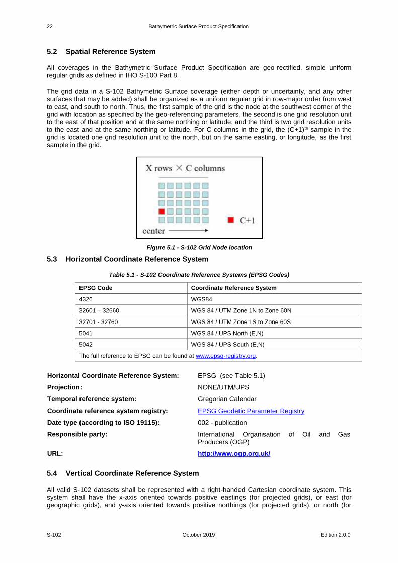
All coverages in the Bathymetric Surface Product Specification are geo-rectified, simple uniform regular grids as defined in IHO S-100 Part 8.
The grid data in a S-102 Bathymetric Surface coverage (either depth or uncertainty, and any other surfaces that may be added) shall be organized as a uniform regular grid in row-major order from west to east, and south to north. Thus, the first sample of the grid is the node at the southwest corner of the grid with location as specified by the geo-referencing parameters, the second is one grid resolution unit to the east of that position and at the same northing or latitude, and the third is two grid resolution units to the east and at the same northing or latitude. For C columns in the grid, the (C+1)th sample in the grid is located one grid resolution unit to the north, but on the same easting, or longitude, as the first sample in the grid.
Figure 5.1 - S-102 Grid Node location
5.3 Horizontal Coordinate Reference System
Table 5.1 - S-102 Coordinate Reference Systems (EPSG Codes)
EPSG Code Coordinate Reference System
4326 WGS84
32601 – 32660 WGS 84 / UTM Zone 1N to Zone 60N
32701 - 32760 WGS 84 / UTM Zone 1S to Zone 60S
5041 WGS 84 / UPS North (E,N)
5042 WGS 84 / UPS South (E,N)
The full reference to EPSG can be found at www.epsg-registry.org.
Horizontal Coordinate Reference System: EPSG (see Table 5.1)
Projection: NONE/UTM/UPS
Temporal reference system: Gregorian Calendar
Coordinate reference system registry: EPSG Geodetic Parameter Registry
Date type (according to ISO 19115): 002 - publication
Responsible party: International Organisation of Oil and Gas Producers (OGP)
URL: http://www.ogp.org.uk/
5.4 Vertical Coordinate Reference System
All valid S-102 datasets shall be represented with a right-handed Cartesian coordinate system. This system shall have the x-axis oriented towards positive eastings (for projected grids), or east (for geographic grids), and y-axis oriented towards positive northings (for projected grids), or north (for
Bathymetric Surface Product Specification 23
S-102 October 2019 Edition 2.0.0
geographic grids). These definitions imply that the z-axis for the sounding data is positive away from the center of mass of the earth (that is, is positive up), rather than the usual hydrographic convention of positive down (that is, deeper depths are larger numbers and negative depths are above datum). User-level code is free to make this reflection if required but must write the data using the positive-up convention. The uncertainty component shall have the same coordinate system as the depth component, with the exception that the z-axis is unipolar, and therefore the concept of direction of positive increase is irrelevant.
5.5 Temporal Reference System
The temporal reference system is the Gregorian calendar for date and UTC for time. Time is measured by reference to Calendar dates and Clock time in accordance with ISO 8601:2004, Temporal Schema, clause 5.4.4. A date-time variable will have the following 16-character format: yyyymmddThhmmssZ.
6 Data Quality
Data quality allows users and user systems to assess fitness for use of the provided data. Data quality measures and the associated evaluation are reported as metadata of a data product. This metadata improves interoperability with other data products and provides usage by user groups that the data product was not originally intended for. The secondary users can make assessments of the data product usefulness in their application based on the reported data quality measures.
6.1 Completeness
6.1.1 Commission
The S-102 bathymetric grid has a high-level of completeness regarding commission, due to the fact that the issuing hydrographic office has deemed the grid to contain all the necessary data and/or considered all contributing factors required to make a navigationally valid product. These factors are recorded in the metadata for the file.
6.1.2 Omission
The S-102 bathymetric grid has a high level of completeness in regards to omission, due to the fact that the issuing hydrographic office will have noted any major discrepancies or negative quality factors in the applicable fields of the metadata for the file.
6.2 Logical Consistency
6.2.1 Conceptual Consistency
The conceptual consistency of S-102 grids is maintained through this and related specifications which are conceptually consistent with the accepted standards.
6.2.2 Domain Consistency
The domain consistency of S-102 grids is maintained through the definition of their primary purpose, which is safety of navigation. The data contained can also be used derivatively for other scientific/fields domains (secondary purposes). All processes used in primary purpose generation is geared solely towards the satisfaction of safety of navigation concerns.
6.2.3 Format Consistency
The formatting consistency of S-102 grids is maintained due to the overriding encoding (HDF5) defined in the S-100 specification and the other IHO standards on which the data is based.
24 Bathymetric Surface Product Specification
S-102 October 2019 Edition 2.0.0
6.3 Positional Accuracy
6.3.1 Accuracy of a Time Measurement
Temporal aspects of bathymetric grids are confined to elements of the vertical control processes. These aspects are addressed during the formulation and application of vertical control processes applied by the various hydrographic offices. Details of these processes will be included in the Lineage portion of the metadata defined in section 12 of this Product Specification.
6.3.2 Gridded Data Positional Accuracy
Gridded positional accuracy is defined by the precision of the positional reference used to specify its location within its spatial projection. These positional references are contained within the spatial metadata of the S-102 grid. Nodes within a bathymetric grid have an absolute position with no horizontal error with vertical values that are calculated for that position by the processes and procedures used by each hydrographic office during the creation of the S-102 grid. Appropriate selection of both the origin reference points and positional resolution are important and are another factor in gridded positional accuracy.
6.3.3 Relative Internal Positional Accuracy
The internal positional accuracy is defined as the precision of the location of each node within the S-102 grid. The position of each node within the grid is referenced by a row and column combination. The metadata for the S-102 defines a gridded resolution along both the X and Y axis of the grid. This absolute position of a node within the spatial projection of the grid is calculated using the row/column and the X/Y resolution. In this case, the accuracy is controlled by the precision used in defining these resolutions.
6.4 Temporal Accuracy
6.4.1 Temporal Consistency
Temporal aspects of bathymetric grids are confined to elements of the vertical control processes. These aspects are addressed during the formulation and application of vertical control processes applied by the various hydrographic offices. Details of these processes will be included in the Lineage portion of the metadata defined in section 12 of this Product Specification.
6.4.2 Temporal Validity
Temporal aspects of bathymetric grids are confined to elements of the vertical control processes. These aspects are addressed during the formulation and application of vertical control processes applied by the various hydrographic offices. Details of these processes will be included in the Lineage portion of the metadata defined in section 12 of this Product Specification.
6.5 Thematic Accuracy
6.5.1 Thematic Classification Correctness
For S-102 bathymetric grids there are two classifications of data values, which are land and water. There are two considerations for accessing classification correctness when using the grid. The first is that values given in the depth layer of the S-102 grid are based on the associated hydrographic offices chosen vertical datum. Should another value in relation to a different vertical datum be required, a series of correctors would need to be applied. Secondly, when considering the data values, the value stored in the corresponding uncertainty node must be considered. This uncertainty value is a +/- value and when assessing the classification correctness must be applied. The new value(s) generated when applied may cause a change in the classification.
Bathymetric Surface Product Specification 25
S-102 October 2019 Edition 2.0.0
6.5.2 Non-Quantitative Attribute Accuracy
Thematic accuracy of S-102 bathymetric data is wholly quantitative.
6.5.3 Quantitative Attribute Accuracy
As defined in IHO S-100 Part 4c the data quality for the depth coverage is also defined as a co-located coverage, uncertainty. Uncertainty is defined as the vertical uncertainty at each node location. The uncertainty coverage supports multiple definitions of vertical uncertainty.
See Table 12.4 - Code describing how uncertainty was determined.
7 Data Capture and Classification
The Data Classification and Encoding Guide (DCEG) describes how data describing the real world should be captured using the types defined in the S-102 Feature Catalogue. This Guide is located at Annex A.
There are a number of sounding techniques, including SONAR and LIDAR that are used to capture bathymetric data. It is permitted, but not required, to include data acquisition information in the metadata of an S-102 Bathymetric Surface product. The metadata class S102_AcquisitionMetadata has been defined, but the information elements to populate this metadata class should be identified in a national profile of S-102.
8 Data Maintenance
8.1 Maintenance and Update Frequency
Datasets are maintained by replacement on a tile or dataset basis. That is, the entire data product or tile within a data set including its coverages (depth, uncertainty, and tracking list point set coverage) and the associated metadata are replaced as a unit. This is unlike vector data that may be updated incrementally. However, coverage data must be considered as a unit at least at the tile level. This is because processing is done on the entire tile to produce the data product. Any replacement tile will include its own tracking list (when a tracking list is used) to deliberately bias the information for safety of navigation. Also, each replacement tile or data set must have its own digital signature.
8.2 Data Source
Data producers must use applicable sources to maintain and update data and provide a brief description of the sources that were used to produce the dataset.
8.3 Production Process
Data Producers should follow their established production processes for maintaining and updating datasets.
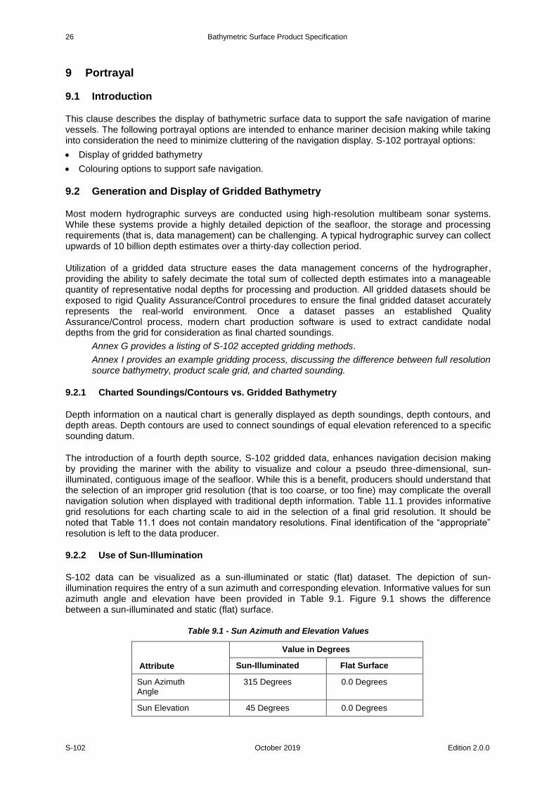
26 Bathymetric Surface Product Specification
S-102 October 2019 Edition 2.0.0
9 Portrayal
9.1 Introduction
This clause describes the display of bathymetric surface data to support the safe navigation of marine vessels. The following portrayal options are intended to enhance mariner decision making while taking into consideration the need to minimize cluttering of the navigation display. S-102 portrayal options:
Display of gridded bathymetry
Colouring options to support safe navigation.
9.2 Generation and Display of Gridded Bathymetry
Most modern hydrographic surveys are conducted using high-resolution multibeam sonar systems. While these systems provide a highly detailed depiction of the seafloor, the storage and processing requirements (that is, data management) can be challenging. A typical hydrographic survey can collect upwards of 10 billion depth estimates over a thirty-day collection period.
Utilization of a gridded data structure eases the data management concerns of the hydrographer, providing the ability to safely decimate the total sum of collected depth estimates into a manageable quantity of representative nodal depths for processing and production. All gridded datasets should be exposed to rigid Quality Assurance/Control procedures to ensure the final gridded dataset accurately represents the real-world environment. Once a dataset passes an established Quality Assurance/Control process, modern chart production software is used to extract candidate nodal depths from the grid for consideration as final charted soundings.
Annex G provides a listing of S-102 accepted gridding methods.
Annex I provides an example gridding process, discussing the difference between full resolution source bathymetry, product scale grid, and charted sounding.
9.2.1 Charted Soundings/Contours vs. Gridded Bathymetry
Depth information on a nautical chart is generally displayed as depth soundings, depth contours, and depth areas. Depth contours are used to connect soundings of equal elevation referenced to a specific sounding datum.
The introduction of a fourth depth source, S-102 gridded data, enhances navigation decision making by providing the mariner with the ability to visualize and colour a pseudo three-dimensional, sun-illuminated, contiguous image of the seafloor. While this is a benefit, producers should understand that the selection of an improper grid resolution (that is too coarse, or too fine) may complicate the overall navigation solution when displayed with traditional depth information. Table 11.1 provides informative grid resolutions for each charting scale to aid in the selection of a final grid resolution. It should be noted that Table 11.1 does not contain mandatory resolutions. Final identification of the “appropriate” resolution is left to the data producer.
9.2.2 Use of Sun-Illumination
S-102 data can be visualized as a sun-illuminated or static (flat) dataset. The depiction of sun-illumination requires the entry of a sun azimuth and corresponding elevation. Informative values for sun azimuth angle and elevation have been provided in Table 9.1. Figure 9.1 shows the difference between a sun-illuminated and static (flat) surface.
Table 9.1 - Sun Azimuth and Elevation Values
Attribute
Value in Degrees
Sun-Illuminated Flat Surface
Sun Azimuth Angle
315 Degrees 0.0 Degrees
Sun Elevation 45 Degrees 0.0 Degrees
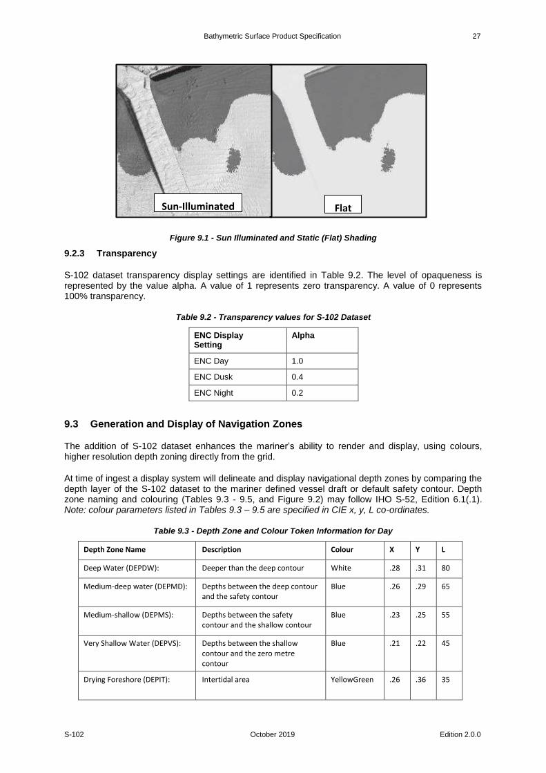
Bathymetric Surface Product Specification 27
S-102 October 2019 Edition 2.0.0
Figure 9.1 - Sun Illuminated and Static (Flat) Shading
9.2.3 Transparency
S-102 dataset transparency display settings are identified in Table 9.2. The level of opaqueness is represented by the value alpha. A value of 1 represents zero transparency. A value of 0 represents 100% transparency.
Table 9.2 - Transparency values for S-102 Dataset
ENC Display Setting
Alpha
ENC Day 1.0
ENC Dusk 0.4
ENC Night 0.2
9.3 Generation and Display of Navigation Zones
The addition of S-102 dataset enhances the mariner’s ability to render and display, using colours, higher resolution depth zoning directly from the grid.
At time of ingest a display system will delineate and display navigational depth zones by comparing the depth layer of the S-102 dataset to the mariner defined vessel draft or default safety contour. Depth zone naming and colouring (Tables 9.3 - 9.5, and Figure 9.2) may follow IHO S-52, Edition 6.1(.1). Note: colour parameters listed in Tables 9.3 – 9.5 are specified in CIE x, y, L co-ordinates.
Table 9.3 - Depth Zone and Colour Token Information for Day
Depth Zone Name Description Colour X Y L
Deep Water (DEPDW): Deeper than the deep contour White .28 .31 80
Medium-deep water (DEPMD): Depths between the deep contour and the safety contour
Blue .26 .29 65
Medium-shallow (DEPMS): Depths between the safety contour and the shallow contour
Blue .23 .25 55
Very Shallow Water (DEPVS): Depths between the shallow contour and the zero metre contour
Blue .21 .22 45
Drying Foreshore (DEPIT): Intertidal area YellowGreen .26 .36 35
Sun - Illuminated Flat
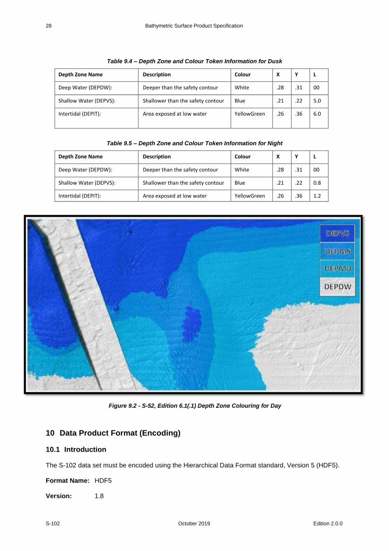
28 Bathymetric Surface Product Specification
S-102 October 2019 Edition 2.0.0
Table 9.4 – Depth Zone and Colour Token Information for Dusk
Depth Zone Name Description Colour X Y L
Deep Water (DEPDW): Deeper than the safety contour White .28 .31 00
Shallow Water (DEPVS): Shallower than the safety contour Blue .21 .22 5.0
Intertidal (DEPIT): Area exposed at low water YellowGreen .26 .36 6.0
Table 9.5 – Depth Zone and Colour Token Information for Night
Depth Zone Name Description Colour X Y L
Deep Water (DEPDW): Deeper than the safety contour White .28 .31 00
Shallow Water (DEPVS): Shallower than the safety contour Blue .21 .22 0.8
Intertidal (DEPIT): Area exposed at low water YellowGreen .26 .36 1.2
Figure 9.2 - S-52, Edition 6.1(.1) Depth Zone Colouring for Day
10 Data Product Format (Encoding)
10.1 Introduction
The S-102 data set must be encoded using the Hierarchical Data Format standard, Version 5 (HDF5).
Format Name: HDF5
Version: 1.8
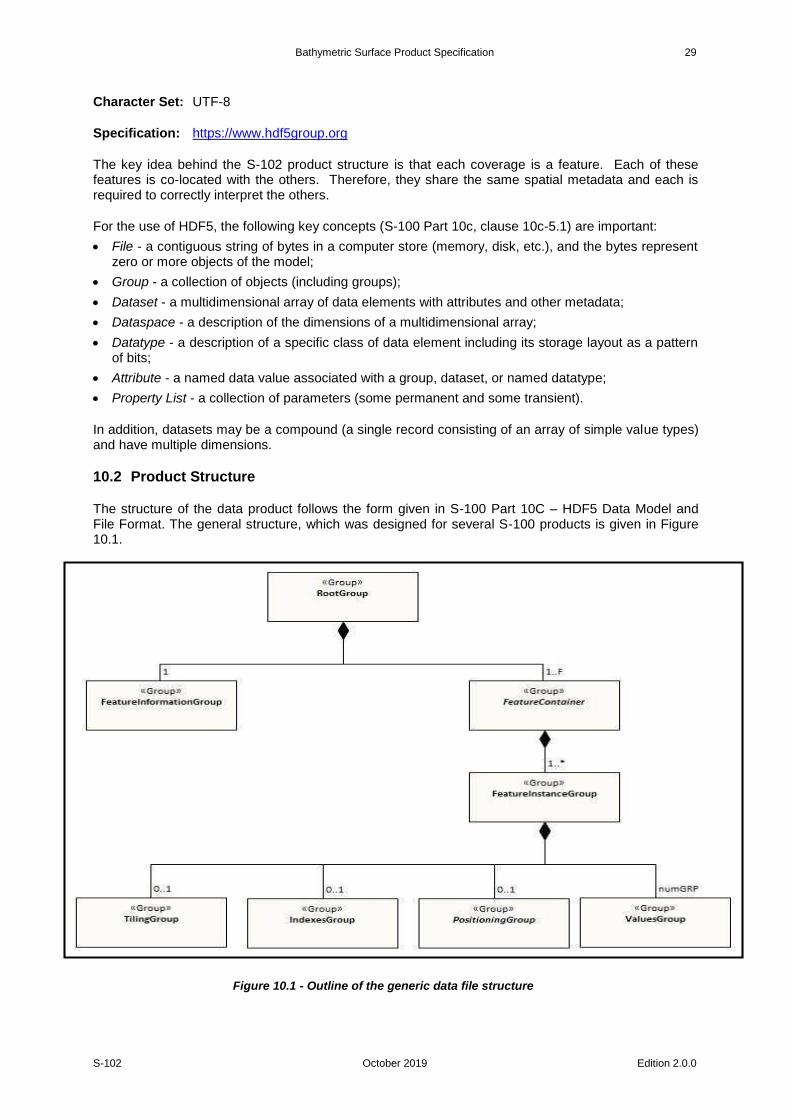
Bathymetric Surface Product Specification 29
S-102 October 2019 Edition 2.0.0
Character Set: UTF-8
Specification: https://www.hdf5group.org
The key idea behind the S-102 product structure is that each coverage is a feature. Each of these features is co-located with the others. Therefore, they share the same spatial metadata and each is required to correctly interpret the others.
For the use of HDF5, the following key concepts (S-100 Part 10c, clause 10c-5.1) are important:
File - a contiguous string of bytes in a computer store (memory, disk, etc.), and the bytes represent zero or more objects of the model;
Group - a collection of objects (including groups);
Dataset - a multidimensional array of data elements with attributes and other metadata;
Dataspace - a description of the dimensions of a multidimensional array;
Datatype - a description of a specific class of data element including its storage layout as a pattern of bits;
Attribute - a named data value associated with a group, dataset, or named datatype;
Property List - a collection of parameters (some permanent and some transient).
In addition, datasets may be a compound (a single record consisting of an array of simple value types) and have multiple dimensions.
10.2 Product Structure
The structure of the data product follows the form given in S-100 Part 10C – HDF5 Data Model and File Format. The general structure, which was designed for several S-100 products is given in Figure 10.1.
Figure 10.1 - Outline of the generic data file structure
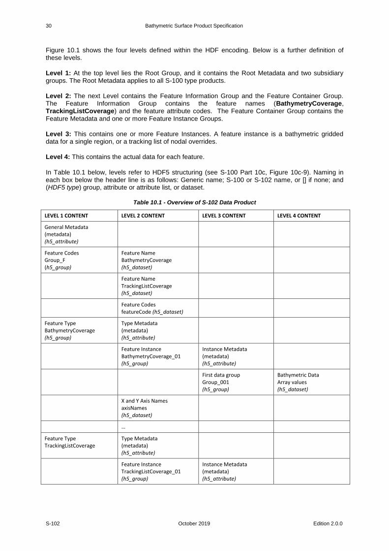
30 Bathymetric Surface Product Specification
S-102 October 2019 Edition 2.0.0
Figure 10.1 shows the four levels defined within the HDF encoding. Below is a further definition of these levels.
Level 1: At the top level lies the Root Group, and it contains the Root Metadata and two subsidiary groups. The Root Metadata applies to all S-100 type products.
Level 2: The next Level contains the Feature Information Group and the Feature Container Group. The Feature Information Group contains the feature names (BathymetryCoverage, TrackingListCoverage) and the feature attribute codes. The Feature Container Group contains the Feature Metadata and one or more Feature Instance Groups.
Level 3: This contains one or more Feature Instances. A feature instance is a bathymetric gridded data for a single region, or a tracking list of nodal overrides.
Level 4: This contains the actual data for each feature.
In Table 10.1 below, levels refer to HDF5 structuring (see S-100 Part 10c, Figure 10c-9). Naming in each box below the header line is as follows: Generic name; S-100 or S-102 name, or [] if none; and (HDF5 type) group, attribute or attribute list, or dataset.
Table 10.1 - Overview of S-102 Data Product
LEVEL 1 CONTENT LEVEL 2 CONTENT LEVEL 3 CONTENT LEVEL 4 CONTENT
General Metadata (metadata) (h5_attribute)
Feature Codes Group_F (h5_group)
Feature Name BathymetryCoverage (h5_dataset)
Feature Name TrackingListCoverage (h5_dataset)
Feature Codes featureCode (h5_dataset)
Feature Type BathymetryCoverage (h5_group)
Type Metadata (metadata) (h5_attribute)
Feature Instance BathymetryCoverage_01 (h5_group)
Instance Metadata (metadata) (h5_attribute)
First data group Group_001 (h5_group)
Bathymetric Data Array values (h5_dataset)
X and Y Axis Names axisNames (h5_dataset)
…
Feature Type TrackingListCoverage
Type Metadata (metadata) (h5_attribute)
Feature Instance TrackingListCoverage_01 (h5_group)
Instance Metadata (metadata) (h5_attribute)
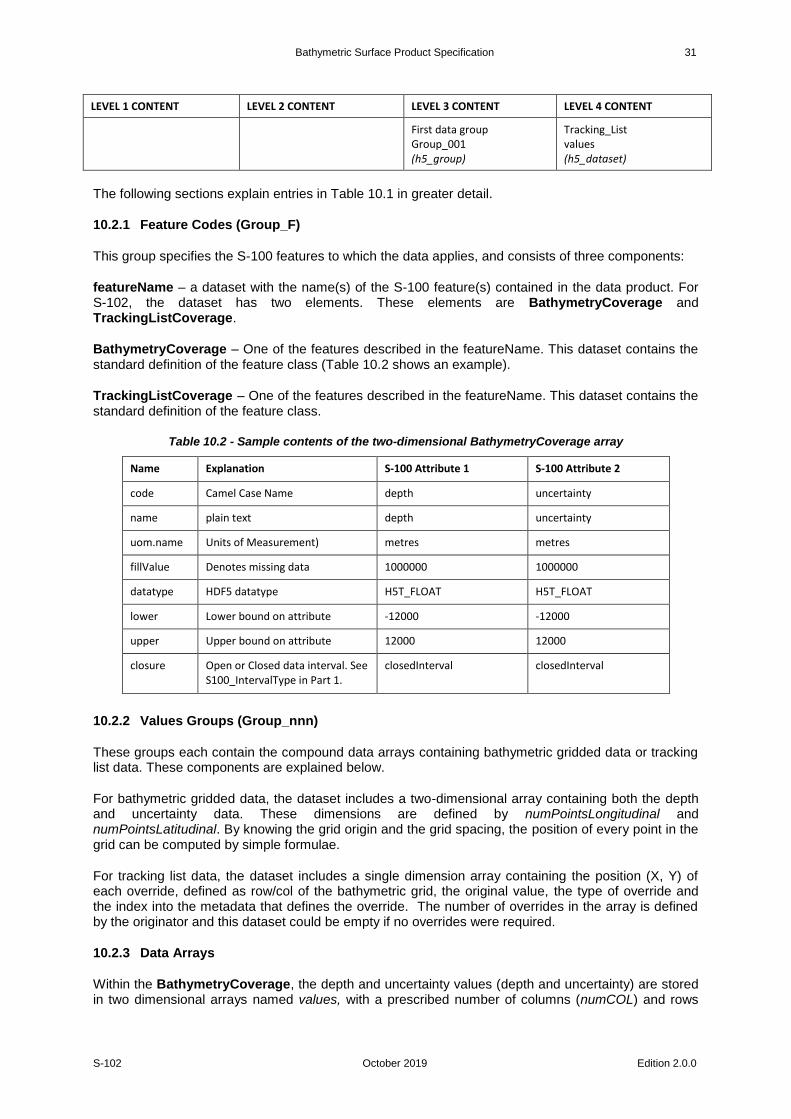
Bathymetric Surface Product Specification 31
S-102 October 2019 Edition 2.0.0
LEVEL 1 CONTENT LEVEL 2 CONTENT LEVEL 3 CONTENT LEVEL 4 CONTENT
First data group Group_001 (h5_group)
Tracking_List values (h5_dataset)
The following sections explain entries in Table 10.1 in greater detail.
10.2.1 Feature Codes (Group_F)
This group specifies the S-100 features to which the data applies, and consists of three components:
featureName – a dataset with the name(s) of the S-100 feature(s) contained in the data product. For S-102, the dataset has two elements. These elements are BathymetryCoverage and TrackingListCoverage.
BathymetryCoverage – One of the features described in the featureName. This dataset contains the standard definition of the feature class (Table 10.2 shows an example).
TrackingListCoverage – One of the features described in the featureName. This dataset contains the standard definition of the feature class.
Table 10.2 - Sample contents of the two-dimensional BathymetryCoverage array
Name Explanation S-100 Attribute 1 S-100 Attribute 2
code Camel Case Name depth uncertainty
name plain text depth uncertainty
uom.name Units of Measurement) metres metres
fillValue Denotes missing data 1000000 1000000
datatype HDF5 datatype H5T_FLOAT H5T_FLOAT
lower Lower bound on attribute -12000 -12000
upper Upper bound on attribute 12000 12000
closure Open or Closed data interval. See S100_IntervalType in Part 1.
closedInterval closedInterval
10.2.2 Values Groups (Group_nnn)
These groups each contain the compound data arrays containing bathymetric gridded data or tracking list data. These components are explained below.
For bathymetric gridded data, the dataset includes a two-dimensional array containing both the depth and uncertainty data. These dimensions are defined by numPointsLongitudinal and numPointsLatitudinal. By knowing the grid origin and the grid spacing, the position of every point in the grid can be computed by simple formulae.
For tracking list data, the dataset includes a single dimension array containing the position (X, Y) of each override, defined as row/col of the bathymetric grid, the original value, the type of override and the index into the metadata that defines the override. The number of overrides in the array is defined by the originator and this dataset could be empty if no overrides were required.
10.2.3 Data Arrays
Within the BathymetryCoverage, the depth and uncertainty values (depth and uncertainty) are stored in two dimensional arrays named values, with a prescribed number of columns (numCOL) and rows
32 Bathymetric Surface Product Specification
S-102 October 2019 Edition 2.0.0
(numROW). This grid is defined as a regular grid (dataCodingFormat = 2), therefore; the depth and uncertainty values will be for each discrete point in the grid. The data array values is two-dimensional.
Within the TrackingListCoverage, entries are stored in a single dimensional array named values. The number of rows in this array is dynamic as entries into this dataset are optional as not all data sources require modifications to the BathymetryCoverage. This grid is defined as a point set (dataCodingFormat = 1), if it exists.
10.2.4 Summary of Generalized Dimensions
To summarize, there are data Groups contains one of two types of feature datasets. The first contains the depth and uncertainty data, which are stored in two-dimensional arrays of size numROW by numCOL. The second is a single dimension array containing information on overrides that were performed on the data in the dataset.
10.2.5 Mandatory Naming Conventions
The following group and attribute names are mandatory in S-100: Group_F, featureCode, and (for S-102) BathymetryCoverage, TrackingListCoverage, axisNames, BathymetryCoverage_01, TrackingListCoverage_01, and Group_nnn. Attribute names shown in Annex G are also mandatory.
10.3 Sample HDF5 Encoding
The product structure has been designed for compatibility with the HDF5 capabilities. The HDF5 encoding of the data set is discussed in Annex B.
11 Data Product Delivery
11.1 Introduction
This clause describes how S-102 data will be delivered from the charting authority to the mariner.
Units of Delivery: Exchange Set
Transfer Size: See clause 11.2.2.
Medium Name: Digital Data Delivery
Other Delivery Information: Each dataset must be contained in a physically separate, uniquely identified file on the transfer medium.
Each exchange set has a single exchange catalogue which contains the discovery metadata for each dataset.
An exchange set is encapsulated into a form suitable for transmission by a mapping called an encoding. An encoding translates each of the elements of the exchange set into a logical form suitable for writing to media and for transmission online. An encoding may also define other elements in addition to the exchange set contents (This is media identification, data extents etc.…) and may define commercial constructs such as encryption and compression methods.
If the data is transformed in S-102 it must not be changed.
This Product Specification defines the encoding which must be used as a default for transmission of data between parties.
The encoding encapsulates exchange set elements as follows:
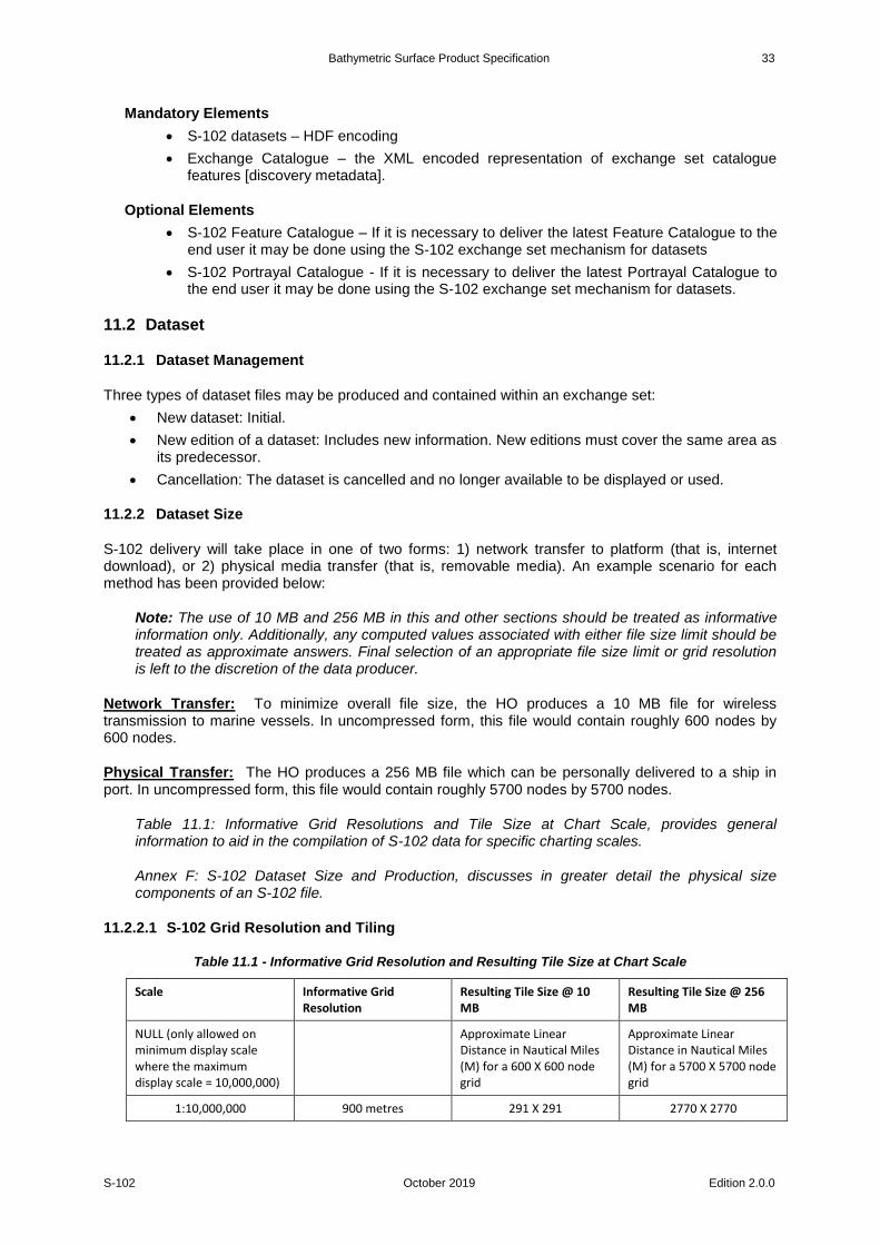
Bathymetric Surface Product Specification 33
S-102 October 2019 Edition 2.0.0
Mandatory Elements
S-102 datasets – HDF encoding
Exchange Catalogue – the XML encoded representation of exchange set catalogue features [discovery metadata].
Optional Elements
S-102 Feature Catalogue – If it is necessary to deliver the latest Feature Catalogue to the end user it may be done using the S-102 exchange set mechanism for datasets
S-102 Portrayal Catalogue - If it is necessary to deliver the latest Portrayal Catalogue to the end user it may be done using the S-102 exchange set mechanism for datasets.
11.2 Dataset
11.2.1 Dataset Management
Three types of dataset files may be produced and contained within an exchange set:
New dataset: Initial.
New edition of a dataset: Includes new information. New editions must cover the same area as its predecessor.
Cancellation: The dataset is cancelled and no longer available to be displayed or used.
11.2.2 Dataset Size
S-102 delivery will take place in one of two forms: 1) network transfer to platform (that is, internet download), or 2) physical media transfer (that is, removable media). An example scenario for each method has been provided below:
Note: The use of 10 MB and 256 MB in this and other sections should be treated as informative information only. Additionally, any computed values associated with either file size limit should be treated as approximate answers. Final selection of an appropriate file size limit or grid resolution is left to the discretion of the data producer.
Network Transfer: To minimize overall file size, the HO produces a 10 MB file for wireless transmission to marine vessels. In uncompressed form, this file would contain roughly 600 nodes by 600 nodes.
Physical Transfer: The HO produces a 256 MB file which can be personally delivered to a ship in port. In uncompressed form, this file would contain roughly 5700 nodes by 5700 nodes.
Table 11.1: Informative Grid Resolutions and Tile Size at Chart Scale, provides general information to aid in the compilation of S-102 data for specific charting scales.
Annex F: S-102 Dataset Size and Production, discusses in greater detail the physical size components of an S-102 file.
11.2.2.1 S-102 Grid Resolution and Tiling
Table 11.1 - Informative Grid Resolution and Resulting Tile Size at Chart Scale
Scale Informative Grid Resolution
Resulting Tile Size @ 10 MB
Resulting Tile Size @ 256 MB
NULL (only allowed on minimum display scale where the maximum display scale = 10,000,000)
Approximate Linear Distance in Nautical Miles (M) for a 600 X 600 node grid
Approximate Linear Distance in Nautical Miles (M) for a 5700 X 5700 node grid
1:10,000,000 900 metres 291 X 291 2770 X 2770
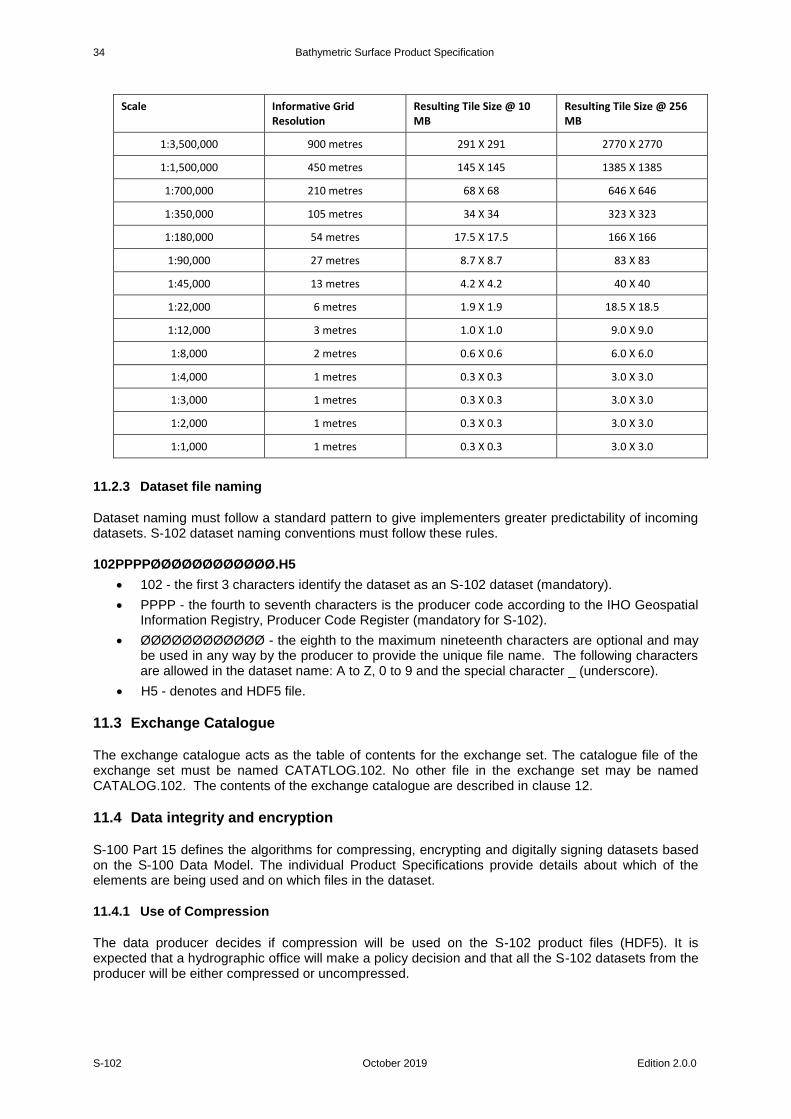
34 Bathymetric Surface Product Specification
S-102 October 2019 Edition 2.0.0
Scale Informative Grid Resolution
Resulting Tile Size @ 10 MB
Resulting Tile Size @ 256 MB
1:3,500,000 900 metres 291 X 291 2770 X 2770
1:1,500,000 450 metres 145 X 145 1385 X 1385
1:700,000 210 metres 68 X 68 646 X 646
1:350,000 105 metres 34 X 34 323 X 323
1:180,000 54 metres 17.5 X 17.5 166 X 166
1:90,000 27 metres 8.7 X 8.7 83 X 83
1:45,000 13 metres 4.2 X 4.2 40 X 40
1:22,000 6 metres 1.9 X 1.9 18.5 X 18.5
1:12,000 3 metres 1.0 X 1.0 9.0 X 9.0
1:8,000 2 metres 0.6 X 0.6 6.0 X 6.0
1:4,000 1 metres 0.3 X 0.3 3.0 X 3.0
1:3,000 1 metres 0.3 X 0.3 3.0 X 3.0
1:2,000 1 metres 0.3 X 0.3 3.0 X 3.0
1:1,000 1 metres 0.3 X 0.3 3.0 X 3.0
11.2.3 Dataset file naming
Dataset naming must follow a standard pattern to give implementers greater predictability of incoming datasets. S-102 dataset naming conventions must follow these rules.
102PPPPØØØØØØØØØØØØ.H5
102 - the first 3 characters identify the dataset as an S-102 dataset (mandatory).
PPPP - the fourth to seventh characters is the producer code according to the IHO Geospatial Information Registry, Producer Code Register (mandatory for S-102).
ØØØØØØØØØØØØ - the eighth to the maximum nineteenth characters are optional and may be used in any way by the producer to provide the unique file name. The following characters are allowed in the dataset name: A to Z, 0 to 9 and the special character _ (underscore).
H5 - denotes and HDF5 file.
11.3 Exchange Catalogue
The exchange catalogue acts as the table of contents for the exchange set. The catalogue file of the exchange set must be named CATATLOG.102. No other file in the exchange set may be named CATALOG.102. The contents of the exchange catalogue are described in clause 12.
11.4 Data integrity and encryption
S-100 Part 15 defines the algorithms for compressing, encrypting and digitally signing datasets based on the S-100 Data Model. The individual Product Specifications provide details about which of the elements are being used and on which files in the dataset.
11.4.1 Use of Compression
The data producer decides if compression will be used on the S-102 product files (HDF5). It is expected that a hydrographic office will make a policy decision and that all the S-102 datasets from the producer will be either compressed or uncompressed.
Bathymetric Surface Product Specification 35
S-102 October 2019 Edition 2.0.0
It is recommended to compress all the dataset files, for example HDF5 files. The ZIP compression method defined in S-100 Part 15 must be applied to the product files.
The use of compression will be encoded:
Since information about compression is encoded in the S-102_ExchangeCatalogue, it is implicitly applied to all the dataset files in the exchange set. It will not be possible to create an exchange set where some HDF5 files are compressed while others are not. In cases where a data distributor produces an integrated S-102 product, all sources are required to be either compressed or uncompressed at time of integration. In this situation the digital signature encoded into source data (that is, original data producer) will be replaced with that of the distributor (Data Server).
11.4.2 Use of Data Protection
It is recommended to encrypt all the dataset files, for example HDF5. The encryption method defined in S-100 Part 15 must be applied.
11.4.3 Use of Digital Signatures
Digital Signatures shall be used on all files included in a S-102 compliant exchange set to meet the requirements of IMO resolution MSC.428(98) to reduce cyber security risks among users, especially when used in navigations systems at sea. The recommended signature method is defined in S-100 Part 15.
The digital signature information is encoded either in the S102_DatasetDiscoveryMetaData or the S102_CatalogueMetadata record for each file included in the exchange set.
12 Metadata
12.1 Introduction
The Metadata elements used in the Bathymetric Surface product are derived from S-100 and from ISO 19115 and ISO 19115-2. Optionally additional metadata may be derived from ISO 19130 and ISO 19130-2
especially metadata relating to the SONAR equipment which may have been used to acquire
the bathymetric data.
There are only a few elements in the ISO 19115 metadata standard that are mandatory and these relate only to the use of the metadata for identification and pedigree of the data set. A minimum level of data identification is required for all applications including database applications, web services and data set production. However, S-102 requires certain metadata attributes which are used to geolocate the dataset as well as lineage attribution which define processes used to establish the tracking list and establish a pedigree for the data.
The elements are related in a metadata schema and include definitions and extension procedures. There exist both mandatory and conditional metadata elements. Only a few metadata elements are mandatory but the inclusion of some of the optional metadata elements establish a situation where other metadata elements are conditionally made mandatory.
The following table outlines the core metadata elements (mandatory and recommended optional) required for describing a geographic information data set. The codes indicate: "M" mandatory, "O" optional' "C" conditional as defined in ISO 19115. The table indicates how the mandatory, optional and conditional core metadata are handled in S-102.
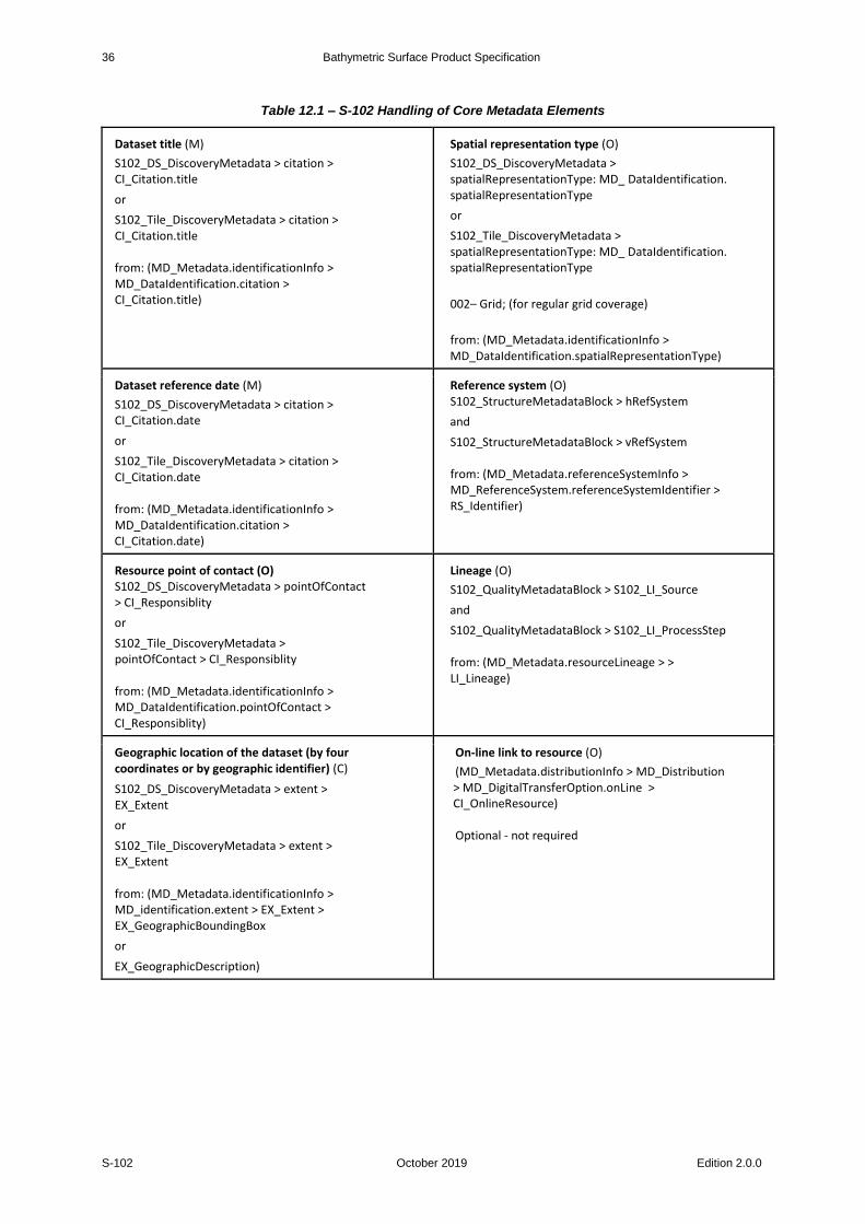
36 Bathymetric Surface Product Specification
S-102 October 2019 Edition 2.0.0
Table 12.1 – S-102 Handling of Core Metadata Elements
Dataset title (M)
S102_DS_DiscoveryMetadata > citation > CI_Citation.title
or
S102_Tile_DiscoveryMetadata > citation > CI_Citation.title from: (MD_Metadata.identificationInfo > MD_DataIdentification.citation > CI_Citation.title)
Spatial representation type (O)
S102_DS_DiscoveryMetadata > spatialRepresentationType: MD_ DataIdentification. spatialRepresentationType
or
S102_Tile_DiscoveryMetadata > spatialRepresentationType: MD_ DataIdentification. spatialRepresentationType
002– Grid; (for regular grid coverage)
from: (MD_Metadata.identificationInfo > MD_DataIdentification.spatialRepresentationType)
Dataset reference date (M)
S102_DS_DiscoveryMetadata > citation > CI_Citation.date
or
S102_Tile_DiscoveryMetadata > citation > CI_Citation.date from: (MD_Metadata.identificationInfo > MD_DataIdentification.citation > CI_Citation.date)
Reference system (O) S102_StructureMetadataBlock > hRefSystem
and
S102_StructureMetadataBlock > vRefSystem from: (MD_Metadata.referenceSystemInfo > MD_ReferenceSystem.referenceSystemIdentifier > RS_Identifier)
Resource point of contact (O) S102_DS_DiscoveryMetadata > pointOfContact > CI_Responsiblity
or
S102_Tile_DiscoveryMetadata > pointOfContact > CI_Responsiblity from: (MD_Metadata.identificationInfo > MD_DataIdentification.pointOfContact > CI_Responsiblity)
Lineage (O)
S102_QualityMetadataBlock > S102_LI_Source
and
S102_QualityMetadataBlock > S102_LI_ProcessStep from: (MD_Metadata.resourceLineage > > LI_Lineage)
Geographic location of the dataset (by four coordinates or by geographic identifier) (C)
S102_DS_DiscoveryMetadata > extent > EX_Extent
or
S102_Tile_DiscoveryMetadata > extent > EX_Extent from: (MD_Metadata.identificationInfo > MD_identification.extent > EX_Extent > EX_GeographicBoundingBox
or
EX_GeographicDescription)
On-line link to resource (O)
(MD_Metadata.distributionInfo > MD_Distribution > MD_DigitalTransferOption.onLine > CI_OnlineResource) Optional - not required
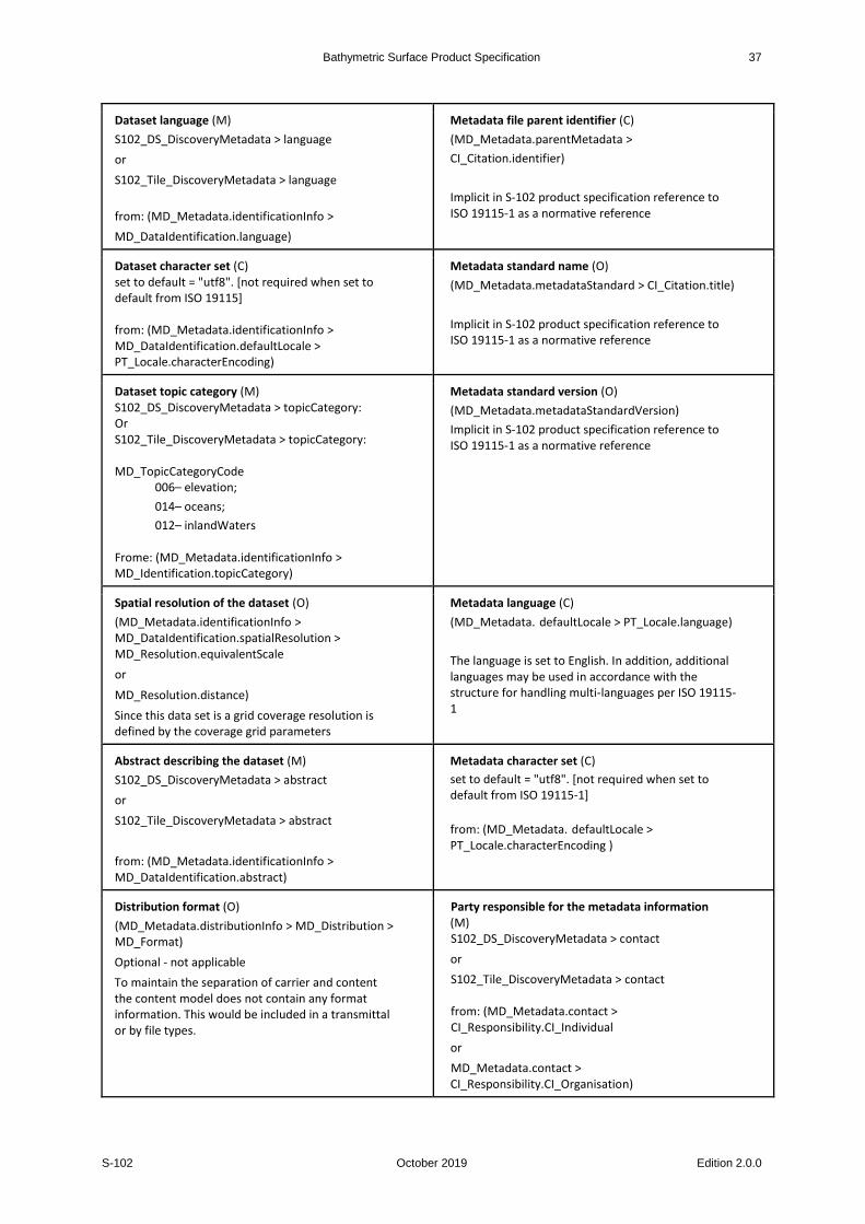
Bathymetric Surface Product Specification 37
S-102 October 2019 Edition 2.0.0
Dataset language (M)
S102_DS_DiscoveryMetadata > language
or
S102_Tile_DiscoveryMetadata > language
from: (MD_Metadata.identificationInfo >
MD_DataIdentification.language)
Metadata file parent identifier (C)
(MD_Metadata.parentMetadata >
CI_Citation.identifier)
Implicit in S-102 product specification reference to ISO 19115-1 as a normative reference
Dataset character set (C) set to default = "utf8". [not required when set to default from ISO 19115] from: (MD_Metadata.identificationInfo > MD_DataIdentification.defaultLocale > PT_Locale.characterEncoding)
Metadata standard name (O)
(MD_Metadata.metadataStandard > CI_Citation.title)
Implicit in S-102 product specification reference to ISO 19115-1 as a normative reference
Dataset topic category (M) S102_DS_DiscoveryMetadata > topicCategory: Or S102_Tile_DiscoveryMetadata > topicCategory: MD_TopicCategoryCode
006– elevation;
014– oceans;
012– inlandWaters Frome: (MD_Metadata.identificationInfo > MD_Identification.topicCategory)
Metadata standard version (O)
(MD_Metadata.metadataStandardVersion)
Implicit in S-102 product specification reference to ISO 19115-1 as a normative reference
Spatial resolution of the dataset (O)
(MD_Metadata.identificationInfo > MD_DataIdentification.spatialResolution > MD_Resolution.equivalentScale
or
MD_Resolution.distance)
Since this data set is a grid coverage resolution is defined by the coverage grid parameters
Metadata language (C)
(MD_Metadata. defaultLocale > PT_Locale.language)
The language is set to English. In addition, additional languages may be used in accordance with the structure for handling multi-languages per ISO 19115-1
Abstract describing the dataset (M)
S102_DS_DiscoveryMetadata > abstract
or
S102_Tile_DiscoveryMetadata > abstract
from: (MD_Metadata.identificationInfo > MD_DataIdentification.abstract)
Metadata character set (C)
set to default = "utf8". [not required when set to default from ISO 19115-1]
from: (MD_Metadata. defaultLocale > PT_Locale.characterEncoding )
Distribution format (O)
(MD_Metadata.distributionInfo > MD_Distribution > MD_Format)
Optional - not applicable
To maintain the separation of carrier and content the content model does not contain any format information. This would be included in a transmittal or by file types.
Party responsible for the metadata information (M) S102_DS_DiscoveryMetadata > contact
or
S102_Tile_DiscoveryMetadata > contact from: (MD_Metadata.contact > CI_Responsibility.CI_Individual
or
MD_Metadata.contact > CI_Responsibility.CI_Organisation)
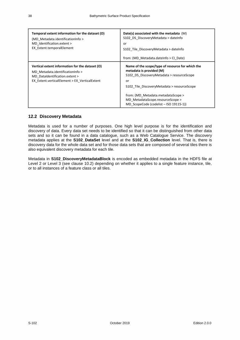
38 Bathymetric Surface Product Specification
S-102 October 2019 Edition 2.0.0
Temporal extent information for the dataset (O)
(MD_Metadata.identificationInfo > MD_Identification.extent > EX_Extent.temporalElement
Date(s) associated with the metadata (M) S102_DS_DiscoveryMetadata > dateInfo
or
S102_Tile_DiscoveryMetadata > dateInfo from: (MD_Metadata.dateInfo > CI_Date)
Vertical extent information for the dataset (O)
MD_Metadata.identificationInfo > MD_DataIdentification.extent > EX_Extent.verticalElement > EX_VerticalExtent
Name of the scope/type of resource for which the metadata is provided (M) S102_DS_DiscoveryMetadata > resourceScope
or
S102_Tile_DiscoveryMetadata > resourceScope from: (MD_Metadata.metadataScope > MD_MetadataScope.resourceScope > MD_ScopeCode (codelist – ISO 19115-1))
12.2 Discovery Metadata
Metadata is used for a number of purposes. One high level purpose is for the identification and discovery of data. Every data set needs to be identified so that it can be distinguished from other data sets and so it can be found in a data catalogue, such as a Web Catalogue Service. The discovery metadata applies at the S102_DataSet level and at the S102_IG_Collection level. That is, there is discovery data for the whole data set and for those data sets that are composed of several tiles there is also equivalent discovery metadata for each tile.
Metadata in S102_DiscoveryMetadataBlock is encoded as embedded metadata in the HDF5 file at Level 2 or Level 3 (see clause 10.2) depending on whether it applies to a single feature instance, tile, or to all instances of a feature class or all tiles.
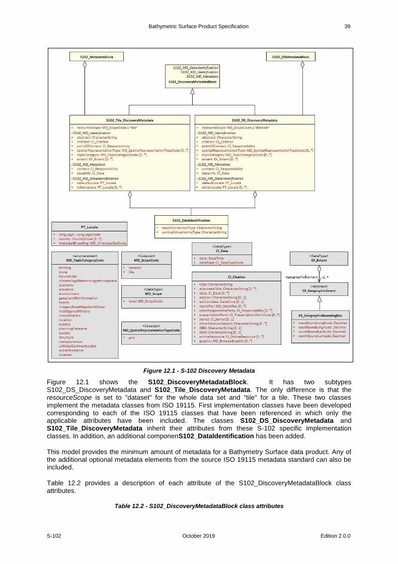
Bathymetric Surface Product Specification 39
S-102 October 2019 Edition 2.0.0
Figure 12.1 - S-102 Discovery Metadata
Figure 12.1 shows the S102_DiscoveryMetadataBlock. It has two subtypes S102_DS_DiscoveryMetadata and S102_Tile_DiscoveryMetadata. The only difference is that the resourceScope is set to "dataset" for the whole data set and "tile" for a tile. These two classes implement the metadata classes from ISO 19115. First implementation classes have been developed corresponding to each of the ISO 19115 classes that have been referenced in which only the applicable attributes have been included. The classes S102_DS_DiscoveryMetadata and S102_Tile_DiscoveryMetadata inherit their attributes from these S-102 specific implementation classes. In addition, an additional componenS102_DataIdentification has been added.
This model provides the minimum amount of metadata for a Bathymetry Surface data product. Any of the additional optional metadata elements from the source ISO 19115 metadata standard can also be included.
Table 12.2 provides a description of each attribute of the S102_DiscoveryMetadataBlock class attributes.
Table 12.2 - S102_DiscoveryMetadataBlock class attributes
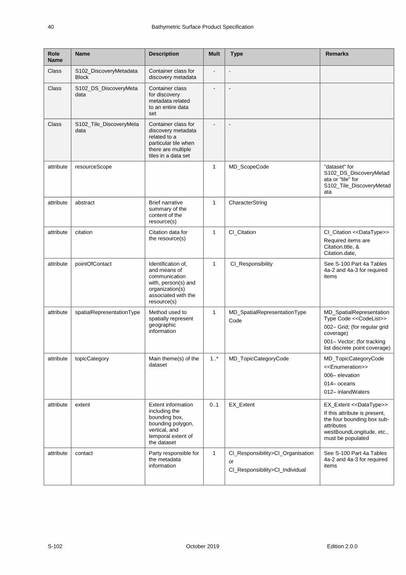
40 Bathymetric Surface Product Specification
S-102 October 2019 Edition 2.0.0
Role Name
Name Description Mult Type Remarks
Class S102_DiscoveryMetadata Block
Container class for discovery metadata
- -
Class S102_DS_DiscoveryMeta data
Container class for discovery metadata related to an entire data set
- -
Class S102_Tile_DiscoveryMeta data
Container class for discovery metadata related to a particular tile when there are multiple tiles in a data set
- -
attribute resourceScope 1 MD_ScopeCode "dataset" for S102_DS_DiscoveryMetadata or "tile" for S102_Tile_DiscoveryMetadata
attribute abstract Brief narrative summary of the content of the resource(s)
1 CharacterString
attribute citation Citation data for the resource(s)
1 CI_Citation CI_Citation <<DataType>>
Required items are Citation.title, & Citation.date,
attribute pointOfContact Identification of, and means of communication with, person(s) and organization(s) associated with the resource(s)
1 CI_Responsibility See S-100 Part 4a Tables 4a-2 and 4a-3 for required items
attribute spatialRepresentationType Method used to spatially represent geographic information
1 MD_SpatialRepresentationType
Code
MD_SpatialRepresentationType Code <<CodeList>>
002– Grid; (for regular grid coverage)
001– Vector; (for tracking list discrete point coverage)
attribute topicCategory Main theme(s) of the dataset
1..* MD_TopicCategoryCode MD_TopicCategoryCode
<<Enumeration>>
006– elevation
014– oceans
012– inlandWaters
attribute extent Extent information including the bounding box, bounding polygon, vertical, and temporal extent of the dataset
0..1 EX_Extent EX_Extent <<DataType>>
If this attribute is present, the four bounding box sub-attributes westBoundLongitude, etc., must be populated
attribute contact Party responsible for the metadata information
1 CI_Responsibility>CI_Organisation
or
CI_Responsibility>CI_Individual
See S-100 Part 4a Tables 4a-2 and 4a-3 for required items
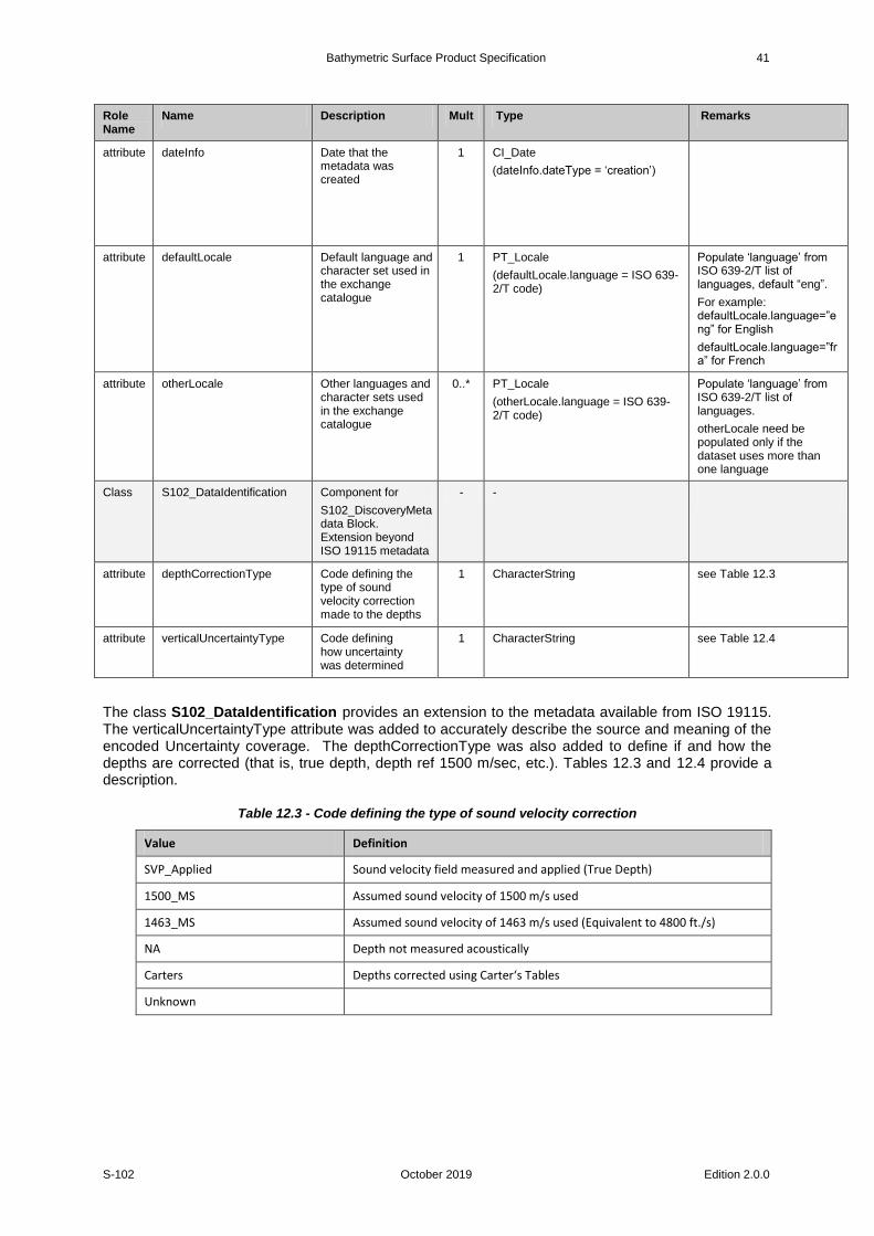
Bathymetric Surface Product Specification 41
S-102 October 2019 Edition 2.0.0
Role Name
Name Description Mult Type Remarks
attribute dateInfo Date that the metadata was created
1 CI_Date
(dateInfo.dateType = ‘creation’)
attribute defaultLocale Default language and character set used in the exchange catalogue
1 PT_Locale
(defaultLocale.language = ISO 639-2/T code)
Populate ‘language’ from ISO 639-2/T list of languages, default “eng”.
For example: defaultLocale.language=”eng” for English
defaultLocale.language=”fra” for French
attribute otherLocale Other languages and character sets used in the exchange catalogue
0..* PT_Locale
(otherLocale.language = ISO 639-2/T code)
Populate ‘language’ from ISO 639-2/T list of languages.
otherLocale need be populated only if the dataset uses more than one language
Class S102_DataIdentification Component for
S102_DiscoveryMeta data Block. Extension beyond ISO 19115 metadata
- -
attribute depthCorrectionType Code defining the type of sound velocity correction made to the depths
1 CharacterString see Table 12.3
attribute verticalUncertaintyType Code defining how uncertainty was determined
1 CharacterString see Table 12.4
The class S102_DataIdentification provides an extension to the metadata available from ISO 19115. The verticalUncertaintyType attribute was added to accurately describe the source and meaning of the encoded Uncertainty coverage. The depthCorrectionType was also added to define if and how the depths are corrected (that is, true depth, depth ref 1500 m/sec, etc.). Tables 12.3 and 12.4 provide a description.
Table 12.3 - Code defining the type of sound velocity correction
Value Definition
SVP_Applied Sound velocity field measured and applied (True Depth)
1500_MS Assumed sound velocity of 1500 m/s used
1463_MS Assumed sound velocity of 1463 m/s used (Equivalent to 4800 ft./s)
NA Depth not measured acoustically
Carters Depths corrected using Carter‘s Tables
Unknown
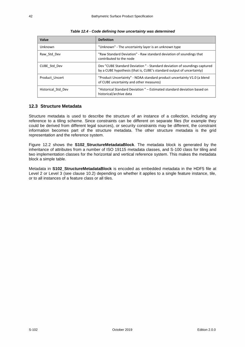
42 Bathymetric Surface Product Specification
S-102 October 2019 Edition 2.0.0
Table 12.4 - Code defining how uncertainty was determined
Value Definition
Unknown "Unknown" - The uncertainty layer is an unknown type
Raw_Std_Dev "Raw Standard Deviation" - Raw standard deviation of soundings that contributed to the node
CUBE_Std_Dev Dev "CUBE Standard Deviation " - Standard deviation of soundings captured by a CUBE hypothesis (that is, CUBE‘s standard output of uncertainty)
Product_Uncert "Product Uncertainty" - NOAA standard product uncertainty V1.0 (a blend of CUBE uncertainty and other measures)
Historical_Std_Dev "Historical Standard Deviation " – Estimated standard deviation based on historical/archive data
12.3 Structure Metadata
Structure metadata is used to describe the structure of an instance of a collection, including any reference to a tiling scheme. Since constraints can be different on separate files (for example they could be derived from different legal sources), or security constraints may be different, the constraint information becomes part of the structure metadata. The other structure metadata is the grid representation and the reference system.
Figure 12.2 shows the S102_StructureMetadataBlock. The metadata block is generated by the inheritance of attributes from a number of ISO 19115 metadata classes, and S-100 class for tiling and two implementation classes for the horizontal and vertical reference system. This makes the metadata block a simple table.
Metadata in S102_StructureMetadataBlock is encoded as embedded metadata in the HDF5 file at Level 2 or Level 3 (see clause 10.2) depending on whether it applies to a single feature instance, tile, or to all instances of a feature class or all tiles.
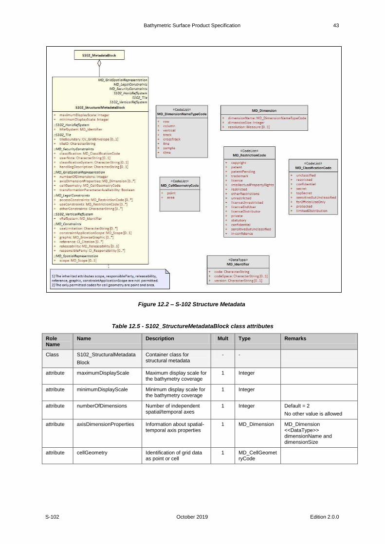
Bathymetric Surface Product Specification 43
S-102 October 2019 Edition 2.0.0
Figure 12.2 – S-102 Structure Metadata
Table 12.5 - S102_StructureMetadataBlock class attributes
Role Name
Name Description Mult Type Remarks
Class S102_StructuralMetadata
Block
Container class for structural metadata
- -
attribute maximumDisplayScale Maximum display scale for the bathymetry coverage
1 Integer
attribute minimumDisplayScale Minimum display scale for the bathymetry coverage
1 Integer
attribute numberOfDimensions Number of independent spatial/temporal axes
1 Integer Default = 2
No other value is allowed
attribute axisDimensionProperties Information about spatial- temporal axis properties
1 MD_Dimension MD_Dimension <<DataType>> dimensionName and dimensionSize
attribute cellGeometry Identification of grid data as point or cell
1 MD_CellGeomet ryCode
44 Bathymetric Surface Product Specification
S-102 October 2019 Edition 2.0.0
Role Name
Name Description Mult Type Remarks
attribute transformationParameterA
vailability
Indication of whether or not parameters for transformation between image coordinates and geographic or map coordinates exist (are available)
1 Boolean 1 = yes
0 = no
Mandatory and must be 1.
attribute vRefSystem Name of vertical reference system
1 MD_Identifier > code, codespace, version
Must be the identifier of a vertical reference system
attribute hRefSystem Name of horizontal reference system
1 MD_Identifier > code, codespace, version
Must be the identifier of a vertical reference system from Table 5-1 – EPSG Codes
attribute accessConstraints Access constraints applied to assure the protection of privacy or intellectual property,and any special restrictions or limitations on obtaining the dataset
0..* MD_Restriction Code
attribute useConstraints Constraints applied to assure the protection of privacy or intellectual property, and any special restrictions or limitations or warnings on using the dataset
0..* MD_Restriction Code
attribute otherConstraints Other restrictions and legal prerequisites for accessing and using the dataset
0..* CharacterString
attribute classification Name of the handling restrictions on the dataset
1 MD_Classificatio nCode
attribute userNote Additional information about the classification
0-1 CharacterString
attribute classificationSystem Name of the classification system
0..1 CharacterString
attribute handlingDescription Additional information about the restrictions on handling the dataset
0..1 CharacterString
attribute tileID Tile identifier 1 CharacterString
attribute tileBoundary Tile boundary 0..1 GM_Curve When not provided is assumed to be the extent of the collection as defined by EX_Extent
Class MD_Dimension Axis properties - -
attribute dimensionName Name of axis 1 MD_DimensionT ypeCode
Defaults are "row" and "column". No other value is allowed
attribute dimensionSize Number of elements along the axis
1 Integer
attribute resolution Degree of detail in the grid dataset
0..1 Measure value= number
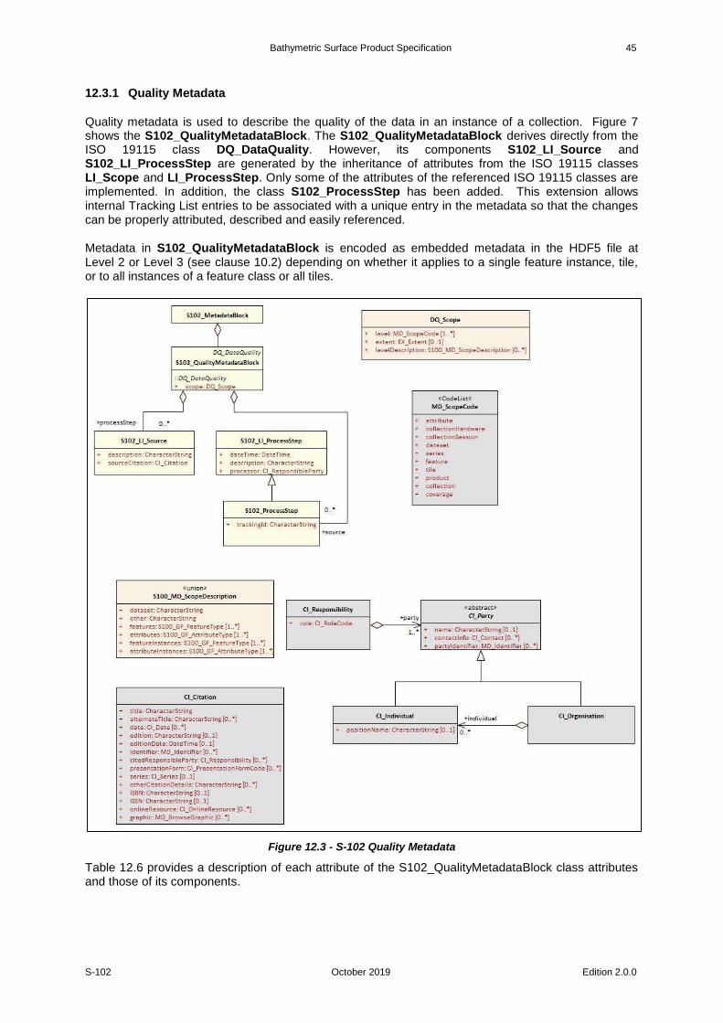
Bathymetric Surface Product Specification 45
S-102 October 2019 Edition 2.0.0
12.3.1 Quality Metadata
Quality metadata is used to describe the quality of the data in an instance of a collection. Figure 7 shows the S102_QualityMetadataBlock. The S102_QualityMetadataBlock derives directly from the ISO 19115 class DQ_DataQuality. However, its components S102_LI_Source and S102_LI_ProcessStep are generated by the inheritance of attributes from the ISO 19115 classes LI_Scope and LI_ProcessStep. Only some of the attributes of the referenced ISO 19115 classes are implemented. In addition, the class S102_ProcessStep has been added. This extension allows internal Tracking List entries to be associated with a unique entry in the metadata so that the changes can be properly attributed, described and easily referenced.
Metadata in S102_QualityMetadataBlock is encoded as embedded metadata in the HDF5 file at Level 2 or Level 3 (see clause 10.2) depending on whether it applies to a single feature instance, tile, or to all instances of a feature class or all tiles.
Figure 12.3 - S-102 Quality Metadata
Table 12.6 provides a description of each attribute of the S102_QualityMetadataBlock class attributes and those of its components.
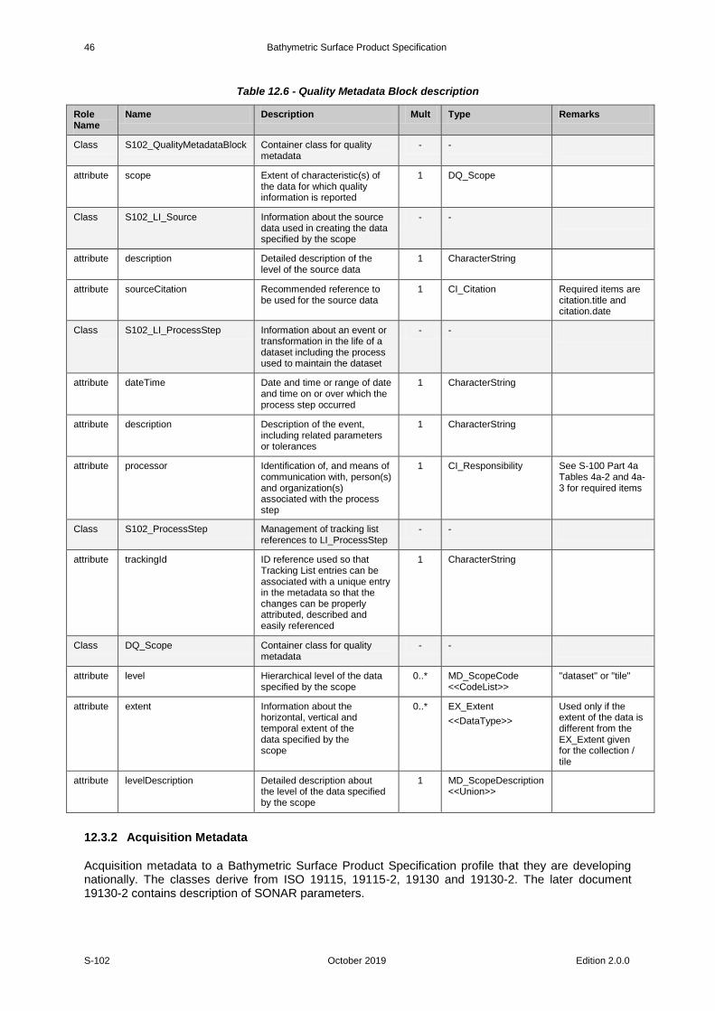
46 Bathymetric Surface Product Specification
S-102 October 2019 Edition 2.0.0
Table 12.6 - Quality Metadata Block description
Role Name
Name Description Mult Type Remarks
Class S102_QualityMetadataBlock Container class for quality metadata
- -
attribute scope Extent of characteristic(s) of the data for which quality information is reported
1 DQ_Scope
Class S102_LI_Source Information about the source data used in creating the data specified by the scope
- -
attribute description Detailed description of the level of the source data
1 CharacterString
attribute sourceCitation Recommended reference to be used for the source data
1 CI_Citation Required items are citation.title and citation.date
Class S102_LI_ProcessStep Information about an event or transformation in the life of a dataset including the process used to maintain the dataset
- -
attribute dateTime Date and time or range of date and time on or over which the process step occurred
1 CharacterString
attribute description Description of the event, including related parameters or tolerances
1 CharacterString
attribute processor Identification of, and means of communication with, person(s) and organization(s) associated with the process step
1 CI_Responsibility See S-100 Part 4a Tables 4a-2 and 4a-3 for required items
Class S102_ProcessStep Management of tracking list references to LI_ProcessStep
- -
attribute trackingId ID reference used so that Tracking List entries can be associated with a unique entry in the metadata so that the changes can be properly attributed, described and easily referenced
1 CharacterString
Class DQ_Scope Container class for quality metadata
- -
attribute level Hierarchical level of the data specified by the scope
0..* MD_ScopeCode <<CodeList>>
"dataset" or "tile"
attribute extent Information about the horizontal, vertical and temporal extent of the data specified by the scope
0..* EX_Extent
<<DataType>>
Used only if the extent of the data is different from the EX_Extent given for the collection / tile
attribute levelDescription Detailed description about the level of the data specified by the scope
1 MD_ScopeDescription <<Union>>
12.3.2 Acquisition Metadata
Acquisition metadata to a Bathymetric Surface Product Specification profile that they are developing nationally. The classes derive from ISO 19115, 19115-2, 19130 and 19130-2. The later document 19130-2 contains description of SONAR parameters.
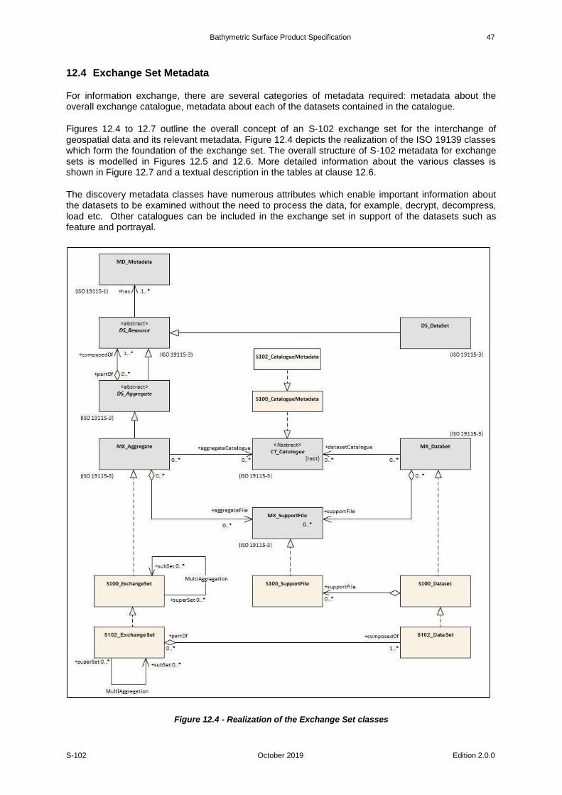
Bathymetric Surface Product Specification 47
S-102 October 2019 Edition 2.0.0
12.4 Exchange Set Metadata
For information exchange, there are several categories of metadata required: metadata about the overall exchange catalogue, metadata about each of the datasets contained in the catalogue.
Figures 12.4 to 12.7 outline the overall concept of an S-102 exchange set for the interchange of geospatial data and its relevant metadata. Figure 12.4 depicts the realization of the ISO 19139 classes which form the foundation of the exchange set. The overall structure of S-102 metadata for exchange sets is modelled in Figures 12.5 and 12.6. More detailed information about the various classes is shown in Figure 12.7 and a textual description in the tables at clause 12.6.
The discovery metadata classes have numerous attributes which enable important information about the datasets to be examined without the need to process the data, for example, decrypt, decompress, load etc. Other catalogues can be included in the exchange set in support of the datasets such as feature and portrayal.
Figure 12.4 - Realization of the Exchange Set classes
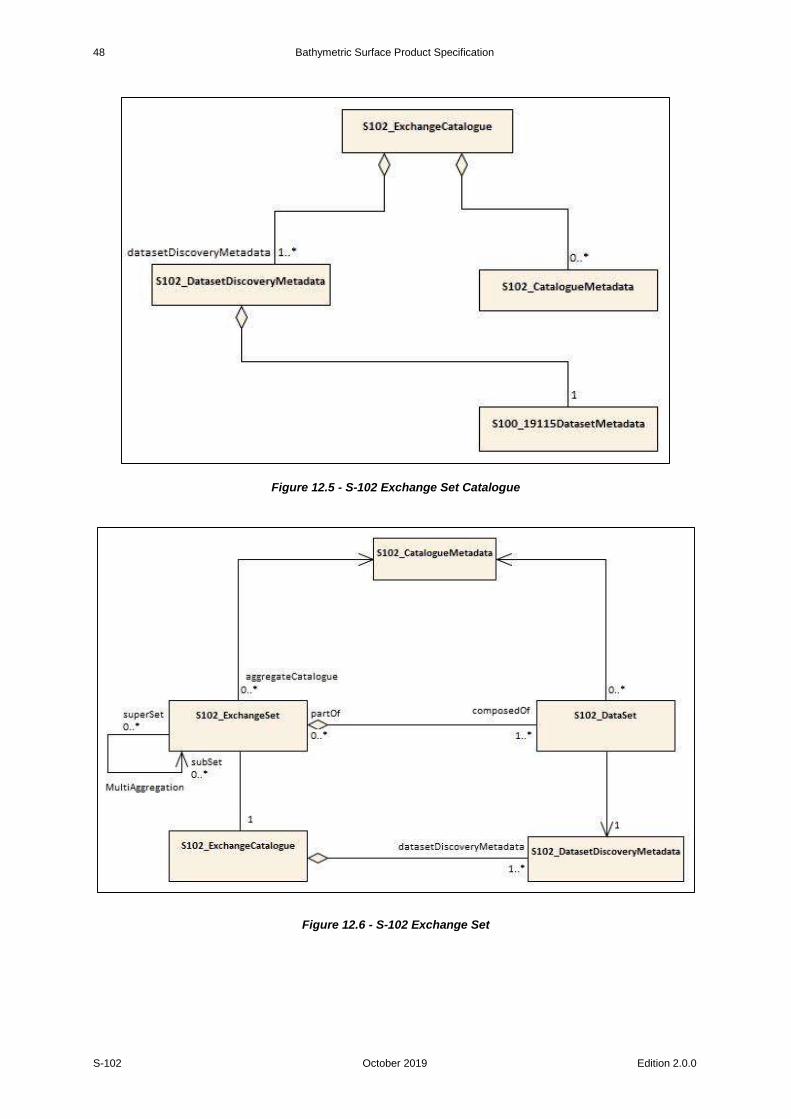
48 Bathymetric Surface Product Specification
S-102 October 2019 Edition 2.0.0
Figure 12.5 - S-102 Exchange Set Catalogue
Figure 12.6 - S-102 Exchange Set
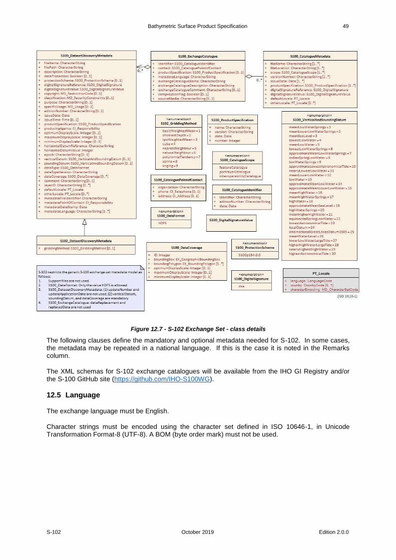
Bathymetric Surface Product Specification 49
S-102 October 2019 Edition 2.0.0
Figure 12.7 - S-102 Exchange Set - class details
The following clauses define the mandatory and optional metadata needed for S-102. In some cases, the metadata may be repeated in a national language. If this is the case it is noted in the Remarks column.
The XML schemas for S-102 exchange catalogues will be available from the IHO GI Registry and/or the S-100 GitHub site (https://github.com/IHO-S100WG).
12.5 Language
The exchange language must be English.
Character strings must be encoded using the character set defined in ISO 10646-1, in Unicode Transformation Format-8 (UTF-8). A BOM (byte order mark) must not be used.

50 Bathymetric Surface Product Specification
S-102 October 2019 Edition 2.0.0
Page intentionally left blank
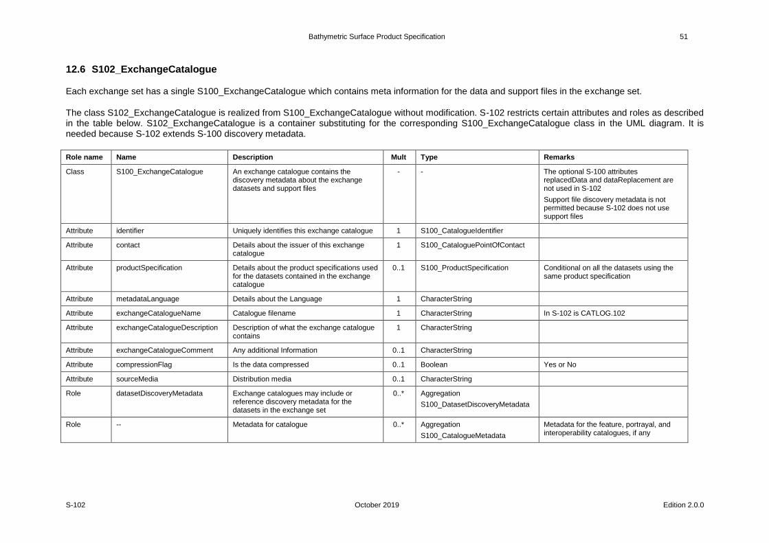
Bathymetric Surface Product Specification 51
S-102 October 2019 Edition 2.0.0
12.6 S102_ExchangeCatalogue
Each exchange set has a single S100_ExchangeCatalogue which contains meta information for the data and support files in the exchange set.
The class S102_ExchangeCatalogue is realized from S100_ExchangeCatalogue without modification. S-102 restricts certain attributes and roles as described in the table below. S102_ExchangeCatalogue is a container substituting for the corresponding S100_ExchangeCatalogue class in the UML diagram. It is needed because S-102 extends S-100 discovery metadata.
Role name Name Description Mult Type Remarks
Class S100_ExchangeCatalogue An exchange catalogue contains the discovery metadata about the exchange datasets and support files
- - The optional S-100 attributes replacedData and dataReplacement are not used in S-102
Support file discovery metadata is not permitted because S-102 does not use support files
Attribute identifier Uniquely identifies this exchange catalogue 1 S100_CatalogueIdentifier
Attribute contact Details about the issuer of this exchange catalogue
1 S100_CataloguePointOfContact
Attribute productSpecification Details about the product specifications used for the datasets contained in the exchange catalogue
0..1 S100_ProductSpecification Conditional on all the datasets using the same product specification
Attribute metadataLanguage Details about the Language 1 CharacterString
Attribute exchangeCatalogueName Catalogue filename 1 CharacterString In S-102 is CATLOG.102
Attribute exchangeCatalogueDescription Description of what the exchange catalogue contains
1 CharacterString
Attribute exchangeCatalogueComment Any additional Information 0..1 CharacterString
Attribute compressionFlag Is the data compressed 0..1 Boolean Yes or No
Attribute sourceMedia Distribution media 0..1 CharacterString
Role datasetDiscoveryMetadata Exchange catalogues may include or reference discovery metadata for the datasets in the exchange set
0..* Aggregation
S100_DatasetDiscoveryMetadata
Role -- Metadata for catalogue 0..* Aggregation
S100_CatalogueMetadata
Metadata for the feature, portrayal, and interoperability catalogues, if any
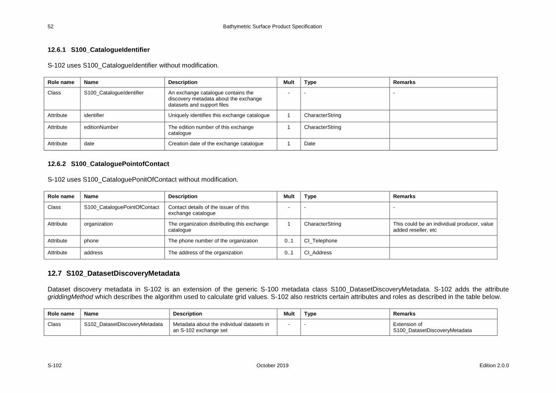
52 Bathymetric Surface Product Specification
S-102 October 2019 Edition 2.0.0
12.6.1 S100_CatalogueIdentifier
S-102 uses S100_CatalogueIdentifier without modification.
Role name Name Description Mult Type Remarks
Class S100_CatalogueIdentifier An exchange catalogue contains the discovery metadata about the exchange datasets and support files
- - -
Attribute identifier Uniquely identifies this exchange catalogue 1 CharacterString
Attribute editionNumber The edition number of this exchange catalogue
1 CharacterString
Attribute date Creation date of the exchange catalogue 1 Date
12.6.2 S100_CataloguePointofContact
S-102 uses S100_CataloguePonitOfContact without modification.
Role name Name Description Mult Type Remarks
Class S100_CataloguePointOfContact Contact details of the issuer of this exchange catalogue
- - -
Attribute organization The organization distributing this exchange catalogue
1 CharacterString This could be an individual producer, value added reseller, etc
Attribute phone The phone number of the organization 0..1 CI_Telephone
Attribute address The address of the organization 0..1 CI_Address
12.7 S102_DatasetDiscoveryMetadata
Dataset discovery metadata in S-102 is an extension of the generic S-100 metadata class S100_DatasetDiscoveryMetadata. S-102 adds the attribute griddingMethod which describes the algorithm used to calculate grid values. S-102 also restricts certain attributes and roles as described in the table below.
Role name Name Description Mult Type Remarks
Class S102_DatasetDiscoveryMetadata Metadata about the individual datasets in an S-102 exchange set
- - Extension of S100_DatasetDiscoveryMetadata
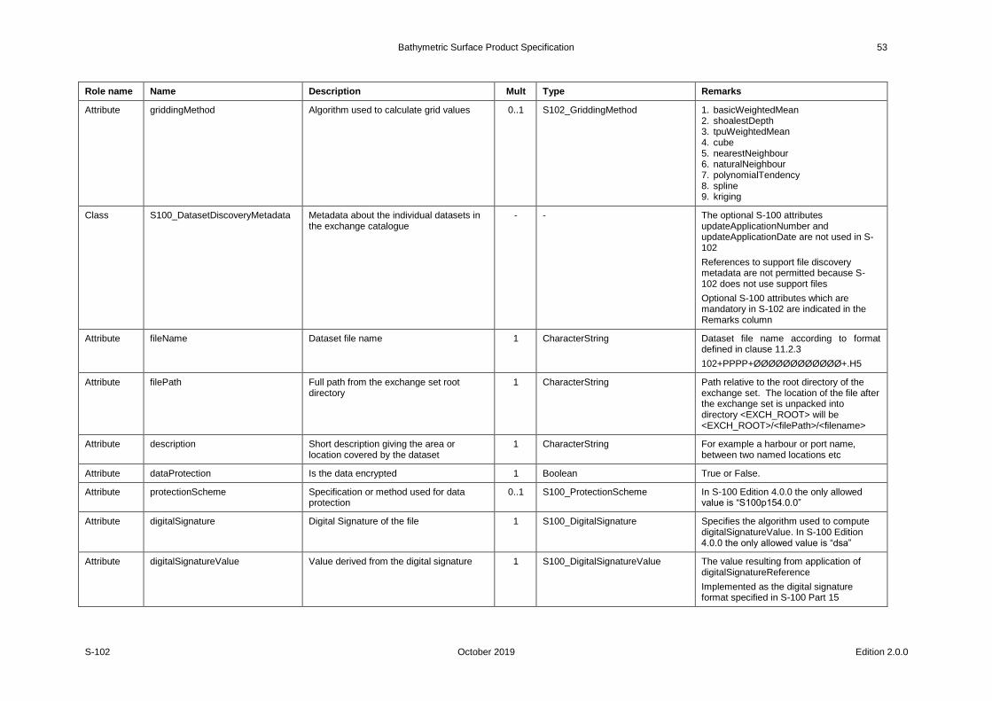
Bathymetric Surface Product Specification 53
S-102 October 2019 Edition 2.0.0
Role name Name Description Mult Type Remarks
Attribute griddingMethod Algorithm used to calculate grid values 0..1 S102_GriddingMethod 1. basicWeightedMean 2. shoalestDepth 3. tpuWeightedMean 4. cube 5. nearestNeighbour 6. naturalNeighbour 7. polynomialTendency 8. spline 9. kriging
Class S100_DatasetDiscoveryMetadata Metadata about the individual datasets in the exchange catalogue
- - The optional S-100 attributes updateApplicationNumber and updateApplicationDate are not used in S-102
References to support file discovery metadata are not permitted because S-102 does not use support files
Optional S-100 attributes which are mandatory in S-102 are indicated in the Remarks column
Attribute fileName Dataset file name 1 CharacterString Dataset file name according to format defined in clause 11.2.3
102+PPPP+ØØØØØØØØØØØØ+.H5
Attribute filePath Full path from the exchange set root directory
1 CharacterString Path relative to the root directory of the exchange set. The location of the file after the exchange set is unpacked into directory <EXCH_ROOT> will be <EXCH_ROOT>/<filePath>/<filename>
Attribute description Short description giving the area or location covered by the dataset
1 CharacterString For example a harbour or port name, between two named locations etc
Attribute dataProtection Is the data encrypted 1 Boolean True or False.
Attribute protectionScheme Specification or method used for data protection
0..1 S100_ProtectionScheme In S-100 Edition 4.0.0 the only allowed value is “S100p154.0.0”
Attribute digitalSignature Digital Signature of the file 1 S100_DigitalSignature Specifies the algorithm used to compute digitalSignatureValue. In S-100 Edition 4.0.0 the only allowed value is “dsa”
Attribute digitalSignatureValue Value derived from the digital signature 1 S100_DigitalSignatureValue The value resulting from application of digitalSignatureReference
Implemented as the digital signature format specified in S-100 Part 15
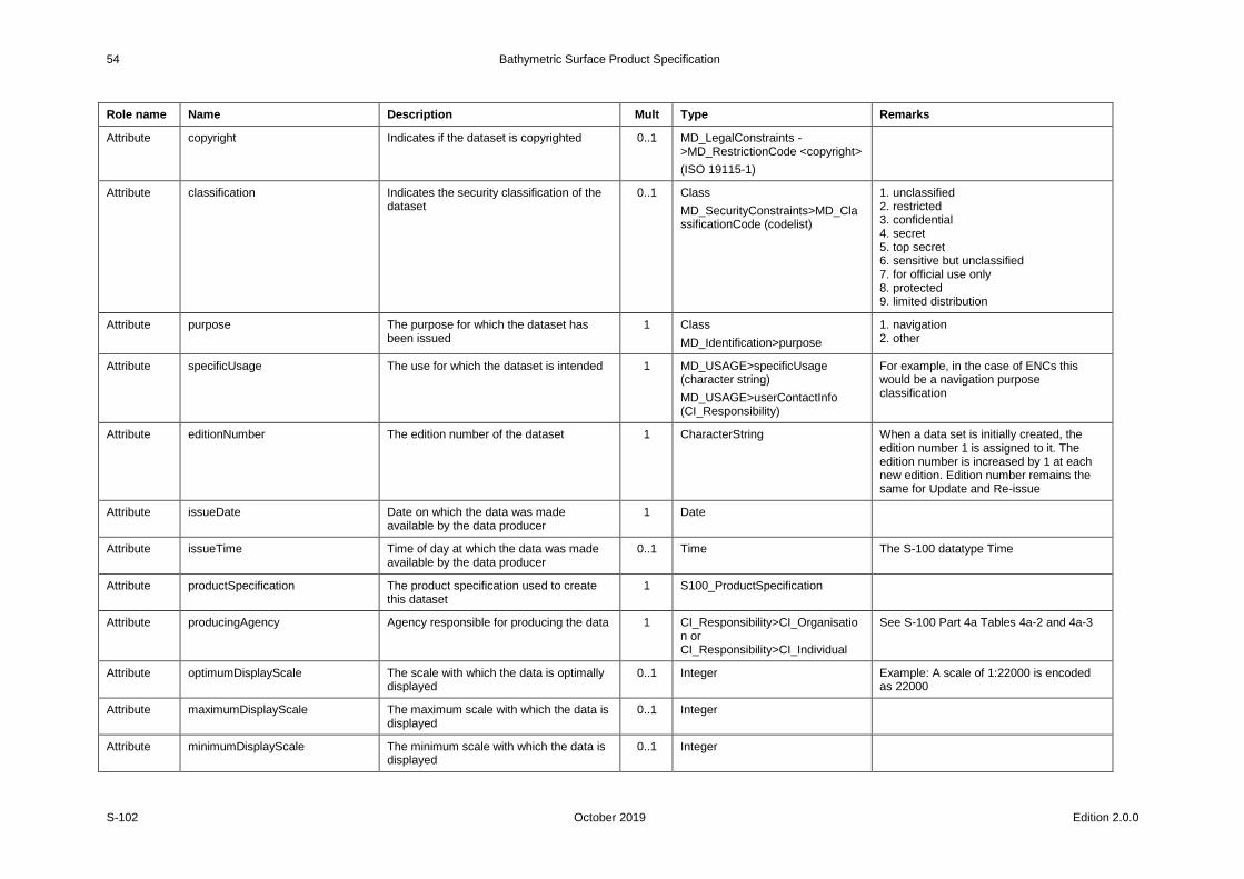
54 Bathymetric Surface Product Specification
S-102 October 2019 Edition 2.0.0
Role name Name Description Mult Type Remarks
Attribute copyright Indicates if the dataset is copyrighted 0..1 MD_LegalConstraints ->MD_RestrictionCode <copyright>
(ISO 19115-1)
Attribute classification Indicates the security classification of the dataset
0..1 Class
MD_SecurityConstraints>MD_Cla ssificationCode (codelist)
1. unclassified 2. restricted 3. confidential 4. secret 5. top secret 6. sensitive but unclassified 7. for official use only 8. protected 9. limited distribution
Attribute purpose The purpose for which the dataset has been issued
1 Class
MD_Identification>purpose
1. navigation 2. other
Attribute specificUsage The use for which the dataset is intended 1 MD_USAGE>specificUsage (character string)
MD_USAGE>userContactInfo (CI_Responsibility)
For example, in the case of ENCs this would be a navigation purpose classification
Attribute editionNumber The edition number of the dataset 1 CharacterString When a data set is initially created, the edition number 1 is assigned to it. The edition number is increased by 1 at each new edition. Edition number remains the same for Update and Re-issue
Attribute issueDate Date on which the data was made available by the data producer
1 Date
Attribute issueTime Time of day at which the data was made available by the data producer
0..1 Time The S-100 datatype Time
Attribute productSpecification The product specification used to create this dataset
1 S100_ProductSpecification
Attribute producingAgency Agency responsible for producing the data 1 CI_Responsibility>CI_Organisation or CI_Responsibility>CI_Individual
See S-100 Part 4a Tables 4a-2 and 4a-3
Attribute optimumDisplayScale The scale with which the data is optimally displayed
0..1 Integer Example: A scale of 1:22000 is encoded as 22000
Attribute maximumDisplayScale The maximum scale with which the data is displayed
0..1 Integer
Attribute minimumDisplayScale The minimum scale with which the data is displayed
0..1 Integer
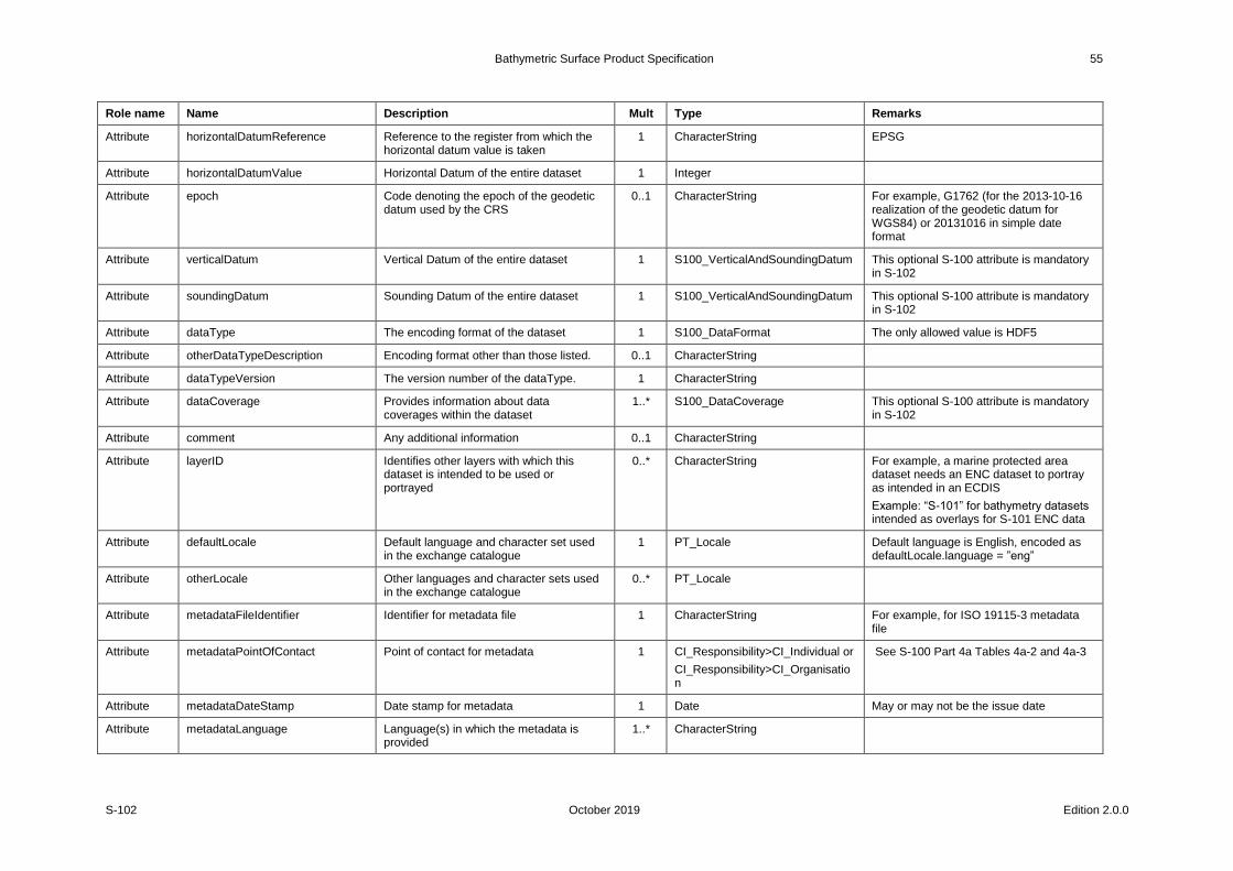
Bathymetric Surface Product Specification 55
S-102 October 2019 Edition 2.0.0
Role name Name Description Mult Type Remarks
Attribute horizontalDatumReference Reference to the register from which the horizontal datum value is taken
1 CharacterString EPSG
Attribute horizontalDatumValue Horizontal Datum of the entire dataset 1 Integer
Attribute epoch Code denoting the epoch of the geodetic datum used by the CRS
0..1 CharacterString For example, G1762 (for the 2013-10-16 realization of the geodetic datum for WGS84) or 20131016 in simple date format
Attribute verticalDatum Vertical Datum of the entire dataset 1 S100_VerticalAndSoundingDatum This optional S-100 attribute is mandatory in S-102
Attribute soundingDatum Sounding Datum of the entire dataset 1 S100_VerticalAndSoundingDatum This optional S-100 attribute is mandatory in S-102
Attribute dataType The encoding format of the dataset 1 S100_DataFormat The only allowed value is HDF5
Attribute otherDataTypeDescription Encoding format other than those listed. 0..1 CharacterString
Attribute dataTypeVersion The version number of the dataType. 1 CharacterString
Attribute dataCoverage Provides information about data coverages within the dataset
1..* S100_DataCoverage This optional S-100 attribute is mandatory in S-102
Attribute comment Any additional information 0..1 CharacterString
Attribute layerID Identifies other layers with which this dataset is intended to be used or portrayed
0..* CharacterString For example, a marine protected area dataset needs an ENC dataset to portray as intended in an ECDIS
Example: “S-101” for bathymetry datasets intended as overlays for S-101 ENC data
Attribute defaultLocale Default language and character set used in the exchange catalogue
1 PT_Locale Default language is English, encoded as defaultLocale.language = ”eng”
Attribute otherLocale Other languages and character sets used in the exchange catalogue
0..* PT_Locale
Attribute metadataFileIdentifier Identifier for metadata file 1 CharacterString For example, for ISO 19115-3 metadata file
Attribute metadataPointOfContact Point of contact for metadata 1 CI_Responsibility>CI_Individual or
CI_Responsibility>CI_Organisation
See S-100 Part 4a Tables 4a-2 and 4a-3
Attribute metadataDateStamp Date stamp for metadata 1 Date May or may not be the issue date
Attribute metadataLanguage Language(s) in which the metadata is provided
1..* CharacterString
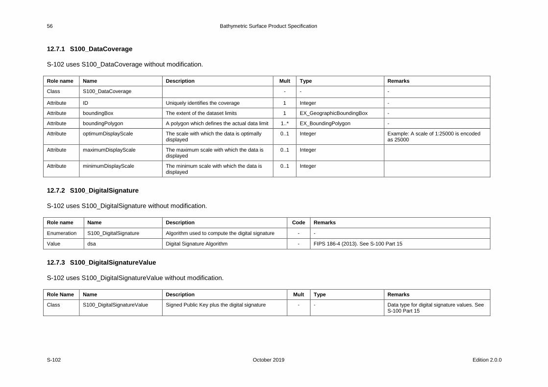
56 Bathymetric Surface Product Specification
S-102 October 2019 Edition 2.0.0
12.7.1 S100_DataCoverage
S-102 uses S100_DataCoverage without modification.
Role name Name Description Mult Type Remarks
Class S100_DataCoverage - - -
Attribute ID Uniquely identifies the coverage 1 Integer -
Attribute boundingBox The extent of the dataset limits 1 EX_GeographicBoundingBox -
Attribute boundingPolygon A polygon which defines the actual data limit 1..* EX_BoundingPolygon -
Attribute optimumDisplayScale The scale with which the data is optimally displayed
0..1 Integer Example: A scale of 1:25000 is encoded as 25000
Attribute maximumDisplayScale The maximum scale with which the data is displayed
0..1 Integer
Attribute minimumDisplayScale The minimum scale with which the data is displayed
0..1 Integer
12.7.2 S100_DigitalSignature
S-102 uses S100_DigitalSignature without modification.
Role name Name Description Code Remarks
Enumeration S100_DigitalSignature Algorithm used to compute the digital signature - -
Value dsa Digital Signature Algorithm - FIPS 186-4 (2013). See S-100 Part 15
12.7.3 S100_DigitalSignatureValue
S-102 uses S100_DigitalSignatureValue without modification.
Role Name Name Description Mult Type Remarks
Class S100_DigitalSignatureValue Signed Public Key plus the digital signature - - Data type for digital signature values. See S-100 Part 15
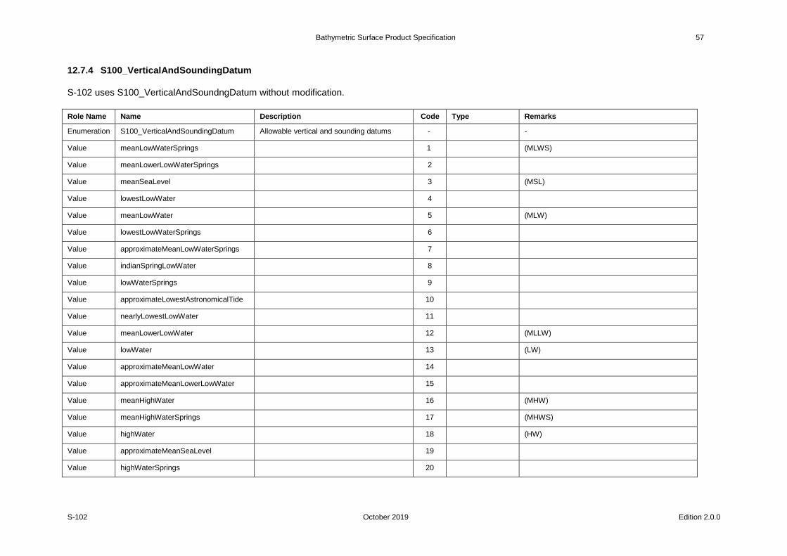
Bathymetric Surface Product Specification 57
S-102 October 2019 Edition 2.0.0
12.7.4 S100_VerticalAndSoundingDatum
S-102 uses S100_VerticalAndSoundngDatum without modification.
Role Name Name Description Code Type Remarks
Enumeration S100_VerticalAndSoundingDatum Allowable vertical and sounding datums - -
Value meanLowWaterSprings 1 (MLWS)
Value meanLowerLowWaterSprings 2
Value meanSeaLevel 3 (MSL)
Value lowestLowWater 4
Value meanLowWater 5 (MLW)
Value lowestLowWaterSprings 6
Value approximateMeanLowWaterSprings 7
Value indianSpringLowWater 8
Value lowWaterSprings 9
Value approximateLowestAstronomicalTide 10
Value nearlyLowestLowWater 11
Value meanLowerLowWater 12 (MLLW)
Value lowWater 13 (LW)
Value approximateMeanLowWater 14
Value approximateMeanLowerLowWater 15
Value meanHighWater 16 (MHW)
Value meanHighWaterSprings 17 (MHWS)
Value highWater 18 (HW)
Value approximateMeanSeaLevel 19
Value highWaterSprings 20
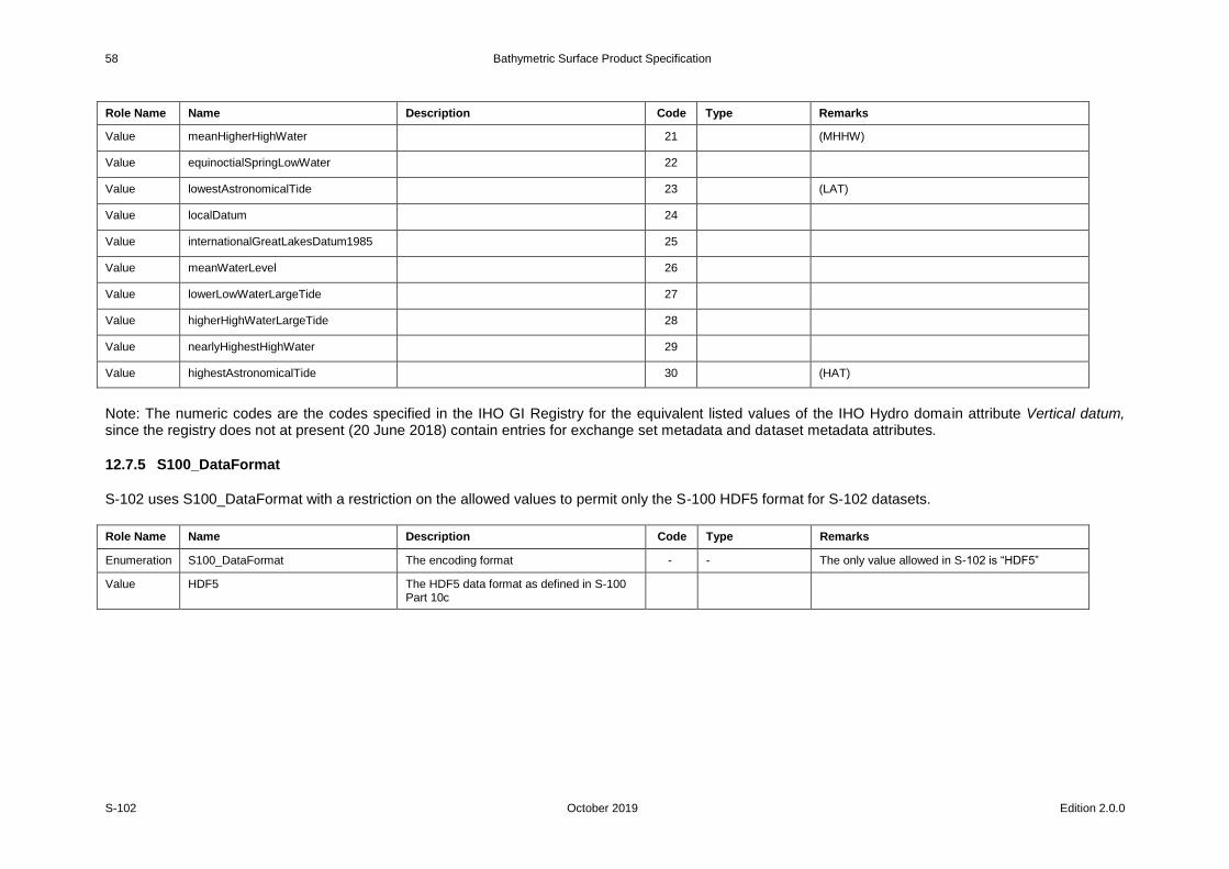
58 Bathymetric Surface Product Specification
S-102 October 2019 Edition 2.0.0
Role Name Name Description Code Type Remarks
Value meanHigherHighWater 21 (MHHW)
Value equinoctialSpringLowWater 22
Value lowestAstronomicalTide 23 (LAT)
Value localDatum 24
Value internationalGreatLakesDatum1985 25
Value meanWaterLevel 26
Value lowerLowWaterLargeTide 27
Value higherHighWaterLargeTide 28
Value nearlyHighestHighWater 29
Value highestAstronomicalTide 30 (HAT)
Note: The numeric codes are the codes specified in the IHO GI Registry for the equivalent listed values of the IHO Hydro domain attribute Vertical datum, since the registry does not at present (20 June 2018) contain entries for exchange set metadata and dataset metadata attributes.
12.7.5 S100_DataFormat
S-102 uses S100_DataFormat with a restriction on the allowed values to permit only the S-100 HDF5 format for S-102 datasets.
Role Name Name Description Code Type Remarks
Enumeration S100_DataFormat The encoding format - - The only value allowed in S-102 is “HDF5”
Value HDF5 The HDF5 data format as defined in S-100 Part 10c
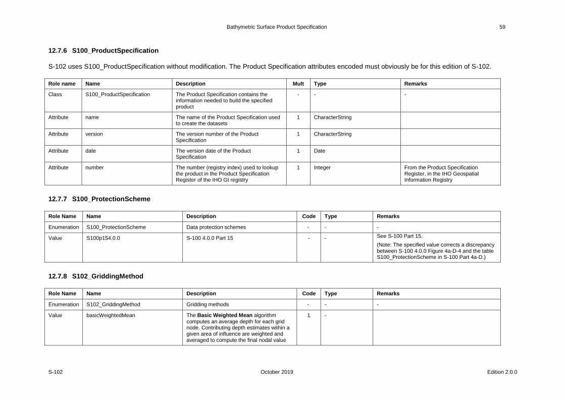
Bathymetric Surface Product Specification 59
S-102 October 2019 Edition 2.0.0
12.7.6 S100_ProductSpecification
S-102 uses S100_ProductSpecification without modification. The Product Specification attributes encoded must obviously be for this edition of S-102.
Role name Name Description Mult Type Remarks
Class S100_ProductSpecification The Product Specification contains the information needed to build the specified product
- - -
Attribute name The name of the Product Specification used to create the datasets
1 CharacterString
Attribute version The version number of the Product Specification
1 CharacterString
Attribute date The version date of the Product Specification
1 Date
Attribute number The number (registry index) used to lookup the product in the Product Specification Register of the IHO GI registry
1 Integer From the Product Specification Register, in the IHO Geospatial Information Registry
12.7.7 S100_ProtectionScheme
Role Name Name Description Code Type Remarks
Enumeration S100_ProtectionScheme Data protection schemes - - -
Value S100p154.0.0 S-100 4.0.0 Part 15 - - See S-100 Part 15.
(Note: The specified value corrects a discrepancy between S-100 4.0.0 Figure 4a-D-4 and the table S100_ProtectionScheme in S-100 Part 4a-D.)
12.7.8 S102_GriddingMethod
Role Name Name Description Code Type Remarks
Enumeration S102_GriddingMethod Gridding methods - - -
Value basicWeightedMean The Basic Weighted Mean algorithm computes an average depth for each grid node. Contributing depth estimates within a given area of influence are weighted and averaged to compute the final nodal value
1 -
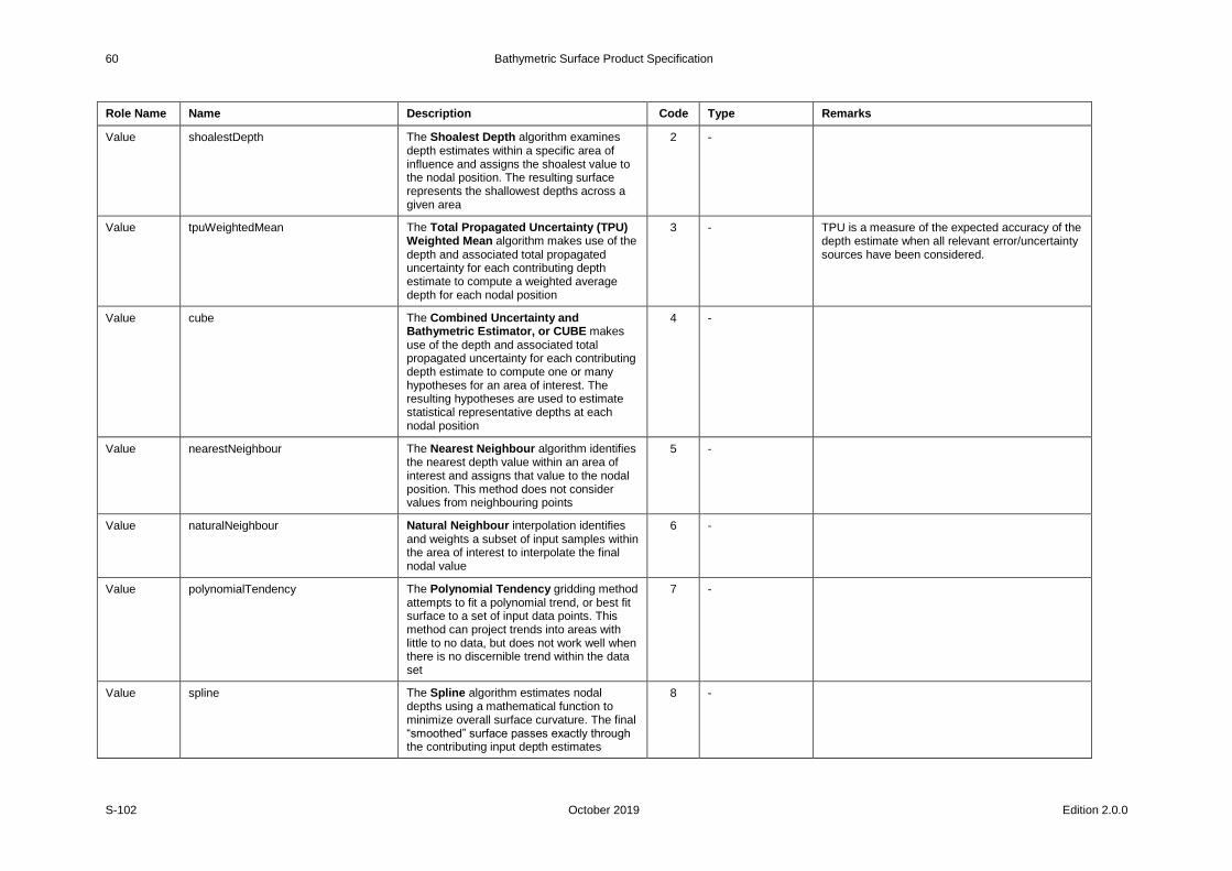
60 Bathymetric Surface Product Specification
S-102 October 2019 Edition 2.0.0
Role Name Name Description Code Type Remarks
Value shoalestDepth The Shoalest Depth algorithm examines depth estimates within a specific area of influence and assigns the shoalest value to the nodal position. The resulting surface represents the shallowest depths across a given area
2 -
Value tpuWeightedMean The Total Propagated Uncertainty (TPU) Weighted Mean algorithm makes use of the depth and associated total propagated uncertainty for each contributing depth estimate to compute a weighted average depth for each nodal position
3 - TPU is a measure of the expected accuracy of the depth estimate when all relevant error/uncertainty sources have been considered.
Value cube The Combined Uncertainty and Bathymetric Estimator, or CUBE makes use of the depth and associated total propagated uncertainty for each contributing depth estimate to compute one or many hypotheses for an area of interest. The resulting hypotheses are used to estimate statistical representative depths at each nodal position
4 -
Value nearestNeighbour The Nearest Neighbour algorithm identifies the nearest depth value within an area of interest and assigns that value to the nodal position. This method does not consider values from neighbouring points
5 -
Value naturalNeighbour Natural Neighbour interpolation identifies and weights a subset of input samples within the area of interest to interpolate the final nodal value
6 -
Value polynomialTendency The Polynomial Tendency gridding method attempts to fit a polynomial trend, or best fit surface to a set of input data points. This method can project trends into areas with little to no data, but does not work well when there is no discernible trend within the data set
7 -
Value spline The Spline algorithm estimates nodal depths using a mathematical function to minimize overall surface curvature. The final “smoothed” surface passes exactly through the contributing input depth estimates
8 -
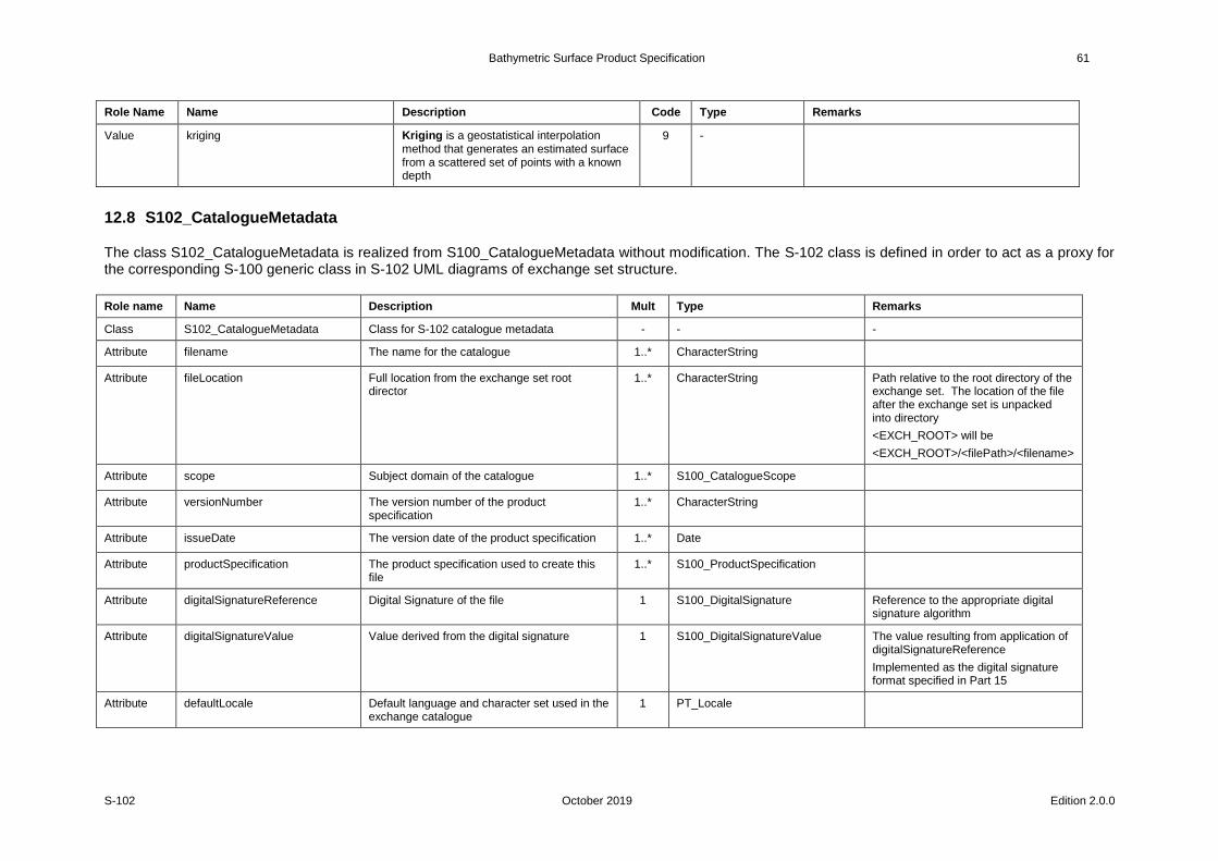
Bathymetric Surface Product Specification 61
S-102 October 2019 Edition 2.0.0
Role Name Name Description Code Type Remarks
Value kriging Kriging is a geostatistical interpolation method that generates an estimated surface from a scattered set of points with a known depth
9 -
12.8 S102_CatalogueMetadata
The class S102_CatalogueMetadata is realized from S100_CatalogueMetadata without modification. The S-102 class is defined in order to act as a proxy for the corresponding S-100 generic class in S-102 UML diagrams of exchange set structure.
Role name Name Description Mult Type Remarks
Class S102_CatalogueMetadata Class for S-102 catalogue metadata - - -
Attribute filename The name for the catalogue 1..* CharacterString
Attribute fileLocation Full location from the exchange set root director
1..* CharacterString Path relative to the root directory of the exchange set. The location of the file after the exchange set is unpacked into directory
<EXCH_ROOT> will be
<EXCH_ROOT>/<filePath>/<filename>
Attribute scope Subject domain of the catalogue 1..* S100_CatalogueScope
Attribute versionNumber The version number of the product specification
1..* CharacterString
Attribute issueDate The version date of the product specification 1..* Date
Attribute productSpecification The product specification used to create this file
1..* S100_ProductSpecification
Attribute digitalSignatureReference Digital Signature of the file 1 S100_DigitalSignature Reference to the appropriate digital signature algorithm
Attribute digitalSignatureValue Value derived from the digital signature 1 S100_DigitalSignatureValue The value resulting from application of digitalSignatureReference
Implemented as the digital signature format specified in Part 15
Attribute defaultLocale Default language and character set used in the exchange catalogue
1 PT_Locale
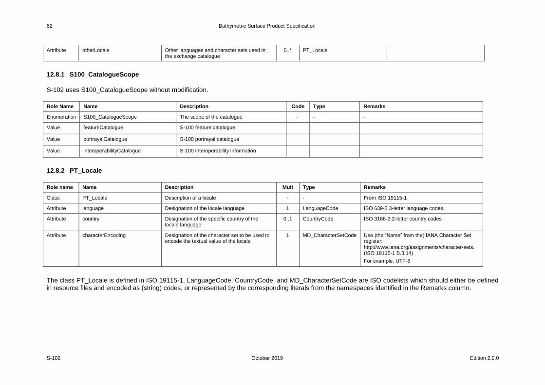
62 Bathymetric Surface Product Specification
S-102 October 2019 Edition 2.0.0
Attribute otherLocale Other languages and character sets used in the exchange catalogue
0..* PT_Locale
12.8.1 S100_CatalogueScope
S-102 uses S100_CatalogueScope without modification.
Role Name Name Description Code Type Remarks
Enumeration S100_CatalogueScope The scope of the catalogue - - -
Value featureCatalogue S-100 feature catalogue
Value portrayalCatalogue S-100 portrayal catalogue
Value interoperabilityCatalogue S-100 interoperability information
12.8.2 PT_Locale
Role name Name Description Mult Type Remarks
Class PT_Locale Description of a locale - - From ISO 19115-1
Attribute language Designation of the locale language 1 LanguageCode ISO 639-2 3-letter language codes.
Attribute country Designation of the specific country of the locale language
0..1 CountryCode ISO 3166-2 2-letter country codes
Attribute characterEncoding Designation of the character set to be used to encode the textual value of the locale
1 MD_CharacterSetCode Use (the “Name” from the) IANA Character Set register: http://www.iana.org/assignments/character-sets. (ISO 19115-1 B.3.14)
For example, UTF-8
The class PT_Locale is defined in ISO 19115-1. LanguageCode, CountryCode, and MD_CharacterSetCode are ISO codelists which should either be defined in resource files and encoded as (string) codes, or represented by the corresponding literals from the namespaces identified in the Remarks column.
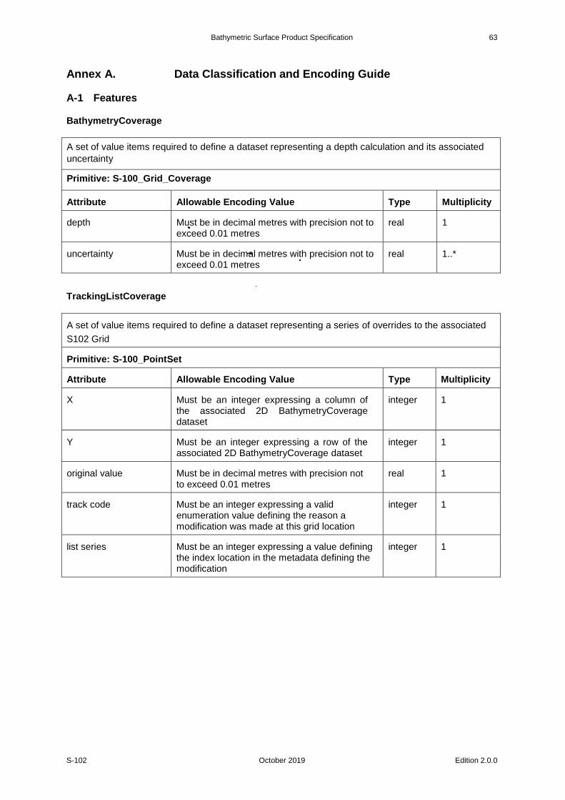
Bathymetric Surface Product Specification 63
S-102 October 2019 Edition 2.0.0
Annex A. Data Classification and Encoding Guide
A-1 Features
BathymetryCoverage
A set of value items required to define a dataset representing a depth calculation and its associated
uncertainty
Primitive: S-100_Grid_Coverage
Attribute Allowable Encoding Value Type Multiplicity
depth Must be in decimal metres with precision not to exceed 0.01 metres
real 1
uncertainty Must be in decimal metres with precision not to exceed 0.01 metres
real 1..*
TrackingListCoverage
A set of value items required to define a dataset representing a series of overrides to the associated
S102 Grid
Primitive: S-100_PointSet
Attribute Allowable Encoding Value Type Multiplicity
X Must be an integer expressing a column of the associated 2D BathymetryCoverage dataset
integer 1
Y Must be an integer expressing a row of the associated 2D BathymetryCoverage dataset
integer 1
original value Must be in decimal metres with precision not to exceed 0.01 metres
real 1
track code Must be an integer expressing a valid enumeration value defining the reason a modification was made at this grid location
integer 1
list series Must be an integer expressing a value defining the index location in the metadata defining the modification
integer 1
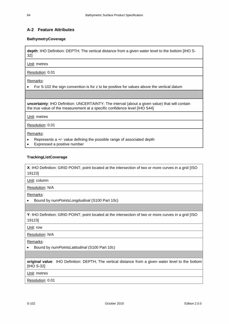
64 Bathymetric Surface Product Specification
S-102 October 2019 Edition 2.0.0
A-2 Feature Attributes
BathymetryCoverage
depth: IHO Definition: DEPTH; The vertical distance from a given water level to the bottom [IHO S-32]
Unit: metres
Resolution: 0.01
Remarks:
For S-102 the sign convention is for z to be positive for values above the vertical datum
uncertainty: IHO Definition: UNCERTAINTY; The interval (about a given value) that will contain the true value of the measurement at a specific confidence level [IHO S44]
Unit: metres
Resolution: 0.01
Remarks:
Represents a +/- value defining the possible range of associated depth
Expressed a positive number
TrackingListCoverage
X: IHO Definition: GRID POINT; point located at the intersection of two or more curves in a grid [ISO
19123]
Unit: column
Resolution: N/A
Remarks:
Bound by numPointsLongitudinal (S100 Part 10c)
Y: IHO Definition: GRID POINT; point located at the intersection of two or more curves in a grid [ISO
19123]
Unit: row
Resolution: N/A
Remarks:
Bound by numPointsLatitudinal (S100 Part 10c)
original value: IHO Definition: DEPTH; The vertical distance from a given water level to the bottom [IHO S-32]
Unit: metres
Resolution: 0.01
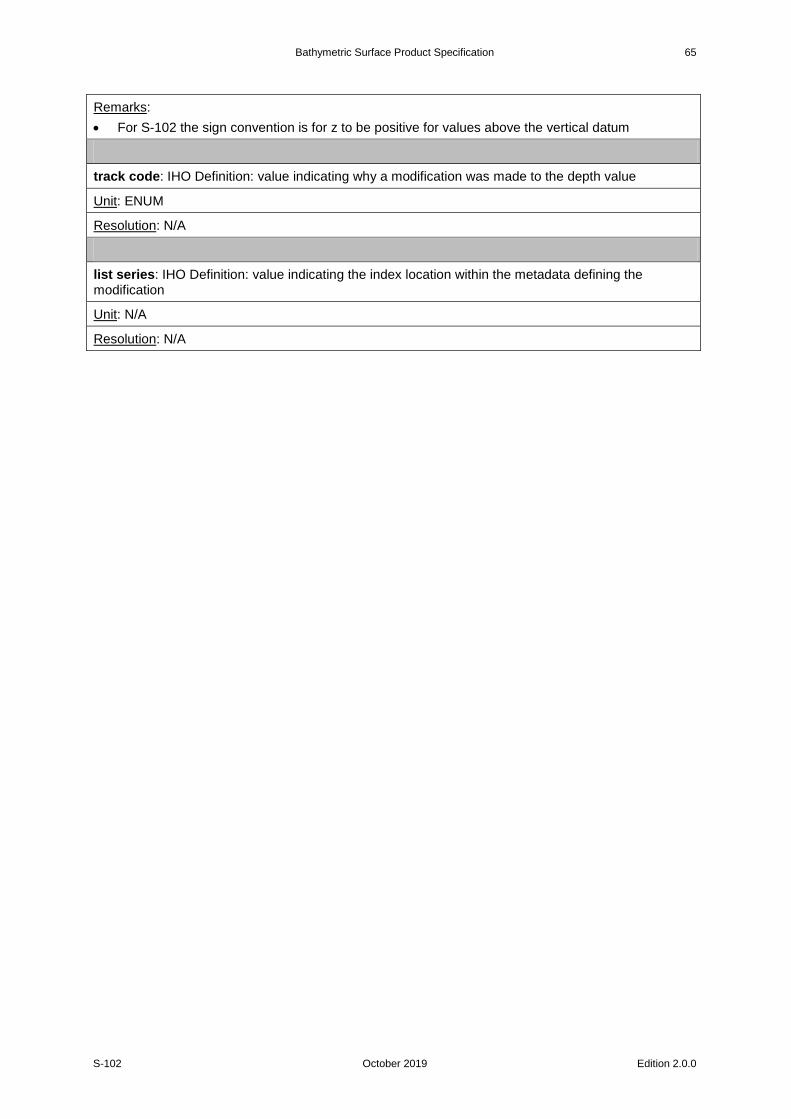
Bathymetric Surface Product Specification 65
S-102 October 2019 Edition 2.0.0
Remarks:
For S-102 the sign convention is for z to be positive for values above the vertical datum
track code: IHO Definition: value indicating why a modification was made to the depth value
Unit: ENUM
Resolution: N/A
list series: IHO Definition: value indicating the index location within the metadata defining the modification
Unit: N/A
Resolution: N/A
66 Bathymetric Surface Product Specification
S-102 October 2019 Edition 2.0.0
Page intentionally left blank
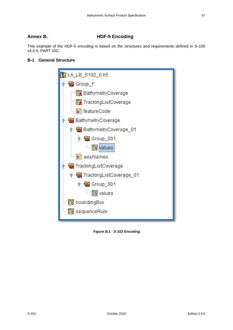
Bathymetric Surface Product Specification 67
S-102 October 2019 Edition 2.0.0
Annex B. HDF-5 Encoding
This example of the HDF-5 encoding is based on the structures and requirements defined in S-100 v4.0.0, PART 10C.
B-1 General Structure
Figure B.1 - S-102 Encoding
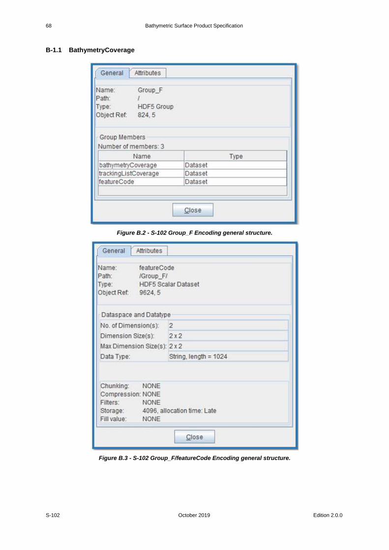
68 Bathymetric Surface Product Specification
S-102 October 2019 Edition 2.0.0
B-1.1 BathymetryCoverage
Figure B.2 - S-102 Group_F Encoding general structure.
Figure B.3 - S-102 Group_F/featureCode Encoding general structure.
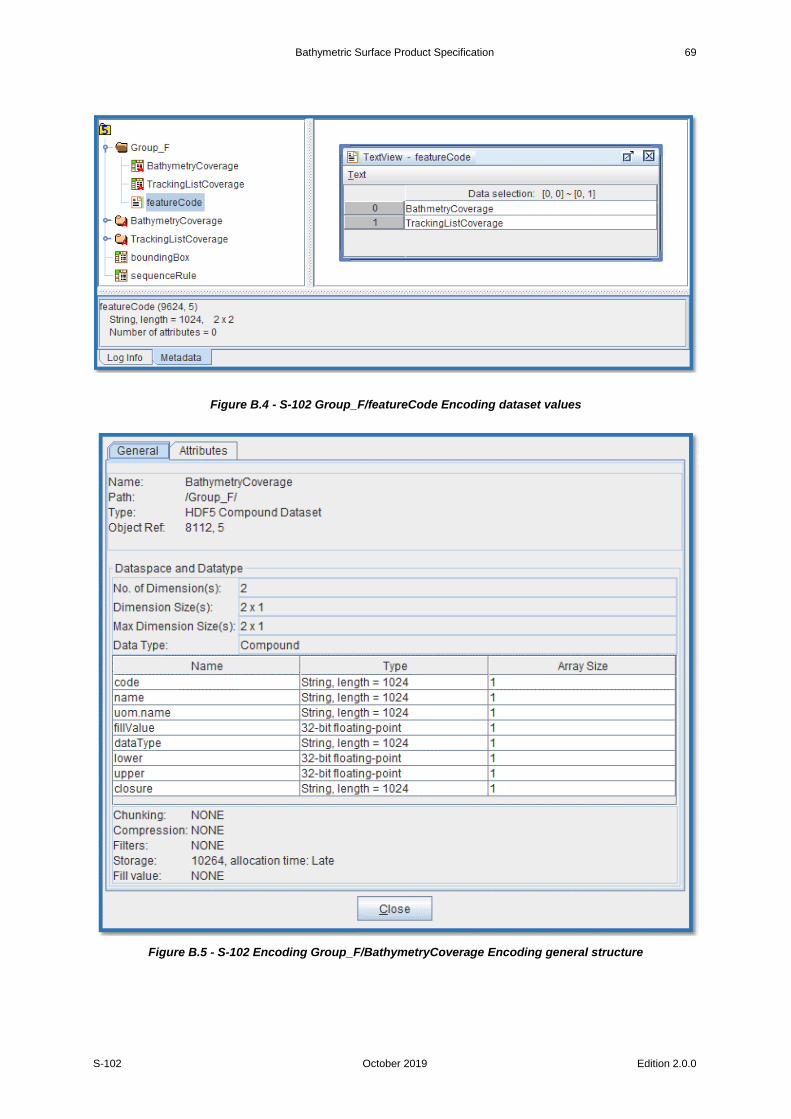
Bathymetric Surface Product Specification 69
S-102 October 2019 Edition 2.0.0
Figure B.4 - S-102 Group_F/featureCode Encoding dataset values
Figure B.5 - S-102 Encoding Group_F/BathymetryCoverage Encoding general structure
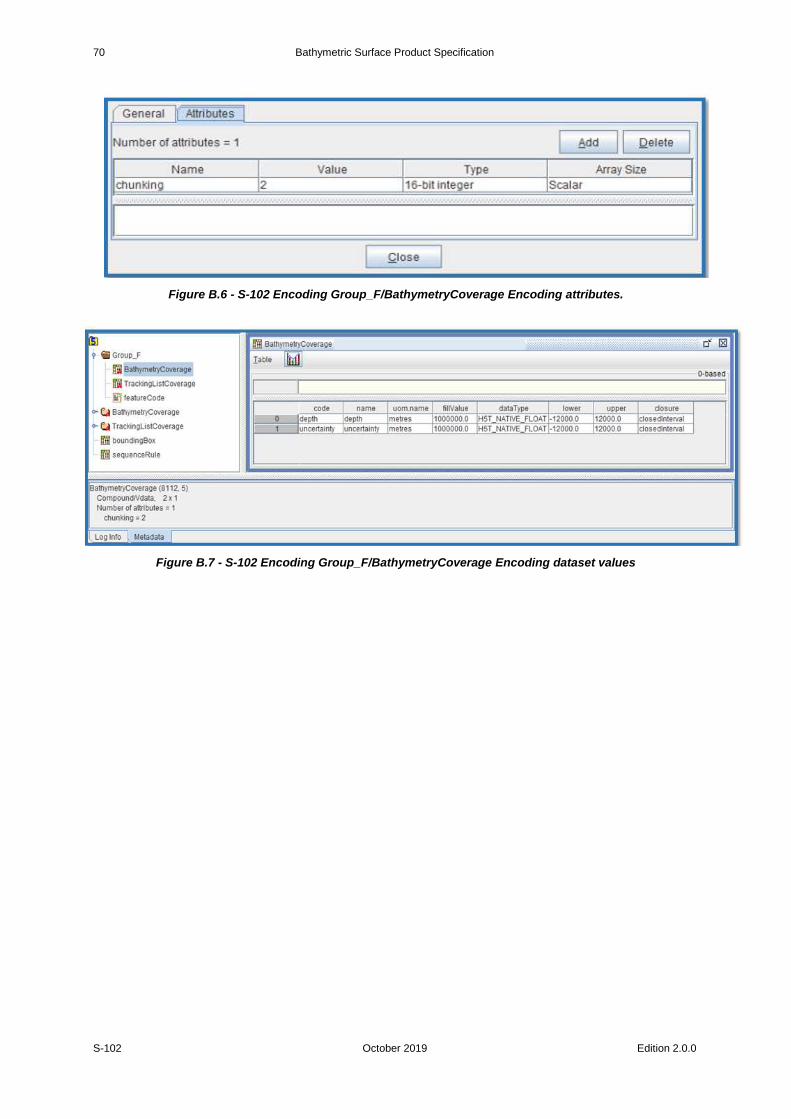
70 Bathymetric Surface Product Specification
S-102 October 2019 Edition 2.0.0
Figure B.6 - S-102 Encoding Group_F/BathymetryCoverage Encoding attributes.
Figure B.7 - S-102 Encoding Group_F/BathymetryCoverage Encoding dataset values
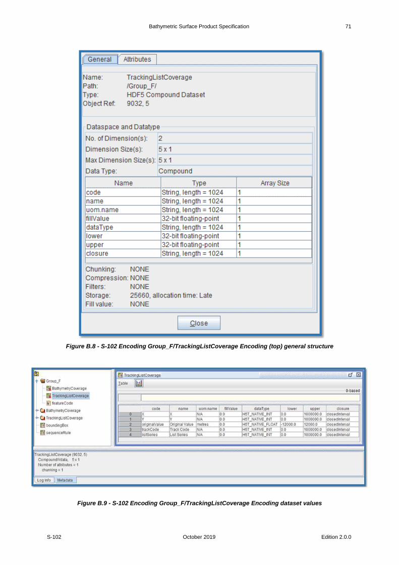
Bathymetric Surface Product Specification 71
S-102 October 2019 Edition 2.0.0
Figure B.8 - S-102 Encoding Group_F/TrackingListCoverage Encoding (top) general structure
Figure B.9 - S-102 Encoding Group_F/TrackingListCoverage Encoding dataset values
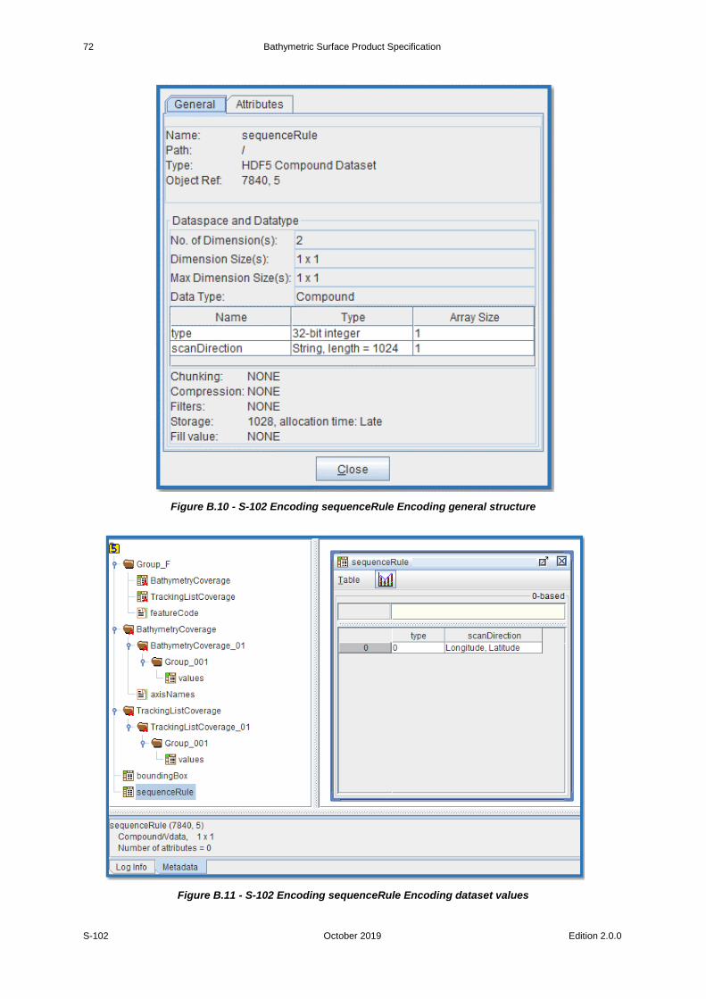
72 Bathymetric Surface Product Specification
S-102 October 2019 Edition 2.0.0
Figure B.10 - S-102 Encoding sequenceRule Encoding general structure
Figure B.11 - S-102 Encoding sequenceRule Encoding dataset values
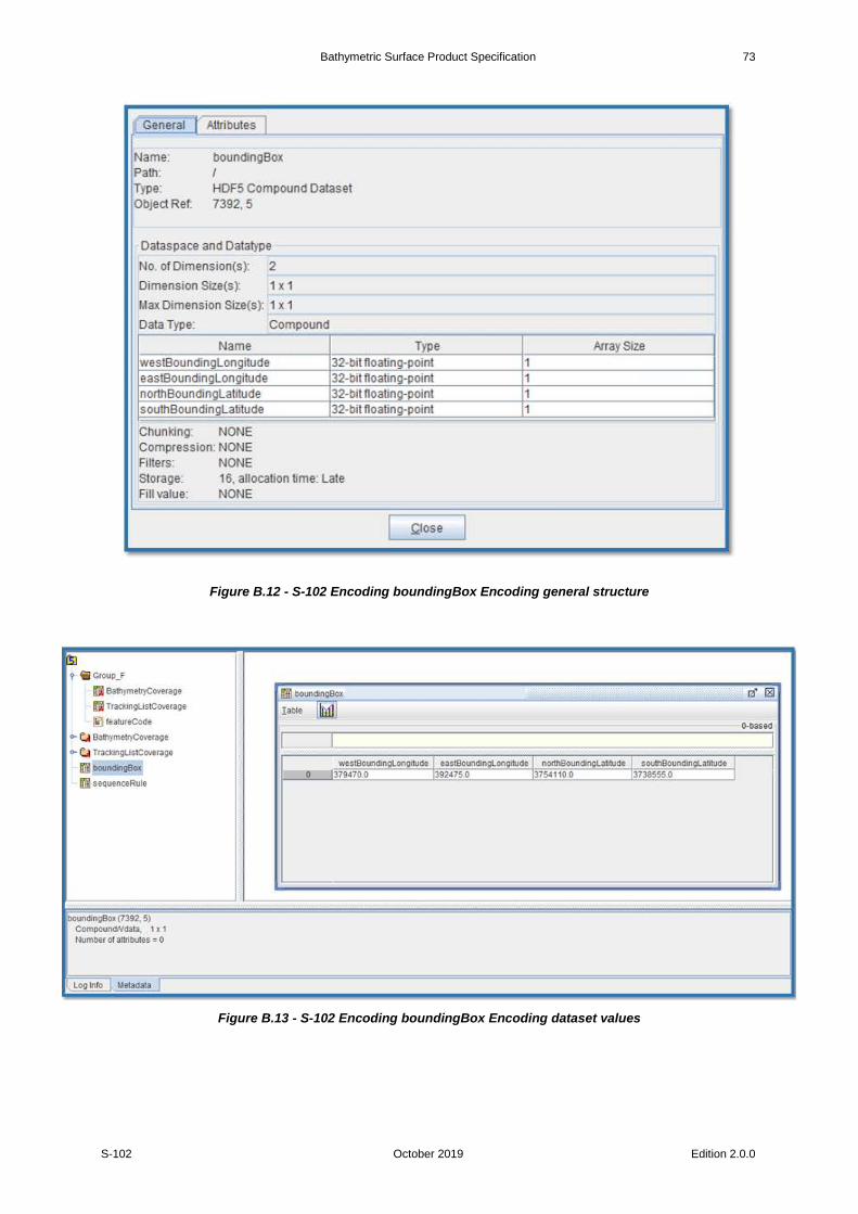
Bathymetric Surface Product Specification 73
S-102 October 2019 Edition 2.0.0
Figure B.12 - S-102 Encoding boundingBox Encoding general structure
Figure B.13 - S-102 Encoding boundingBox Encoding dataset values
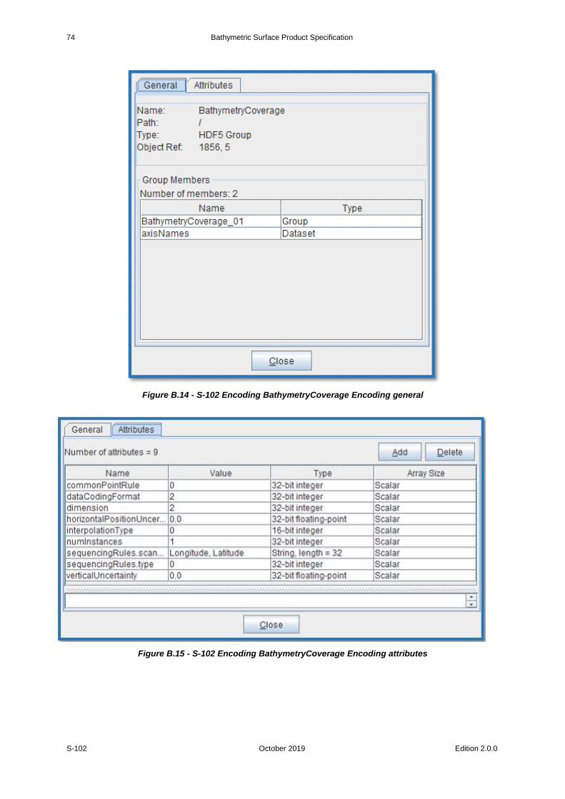
74 Bathymetric Surface Product Specification
S-102 October 2019 Edition 2.0.0
Figure B.14 - S-102 Encoding BathymetryCoverage Encoding general
Figure B.15 - S-102 Encoding BathymetryCoverage Encoding attributes
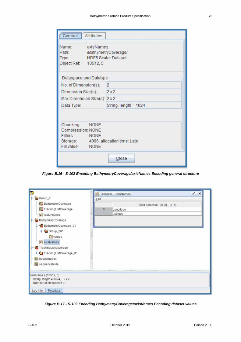
Bathymetric Surface Product Specification 75
S-102 October 2019 Edition 2.0.0
Figure B.16 - S-102 Encoding BathymetryCoverage/axisNames Encoding general structure
Figure B.17 - S-102 Encoding BathymetryCoverage/axisNames Encoding dataset values
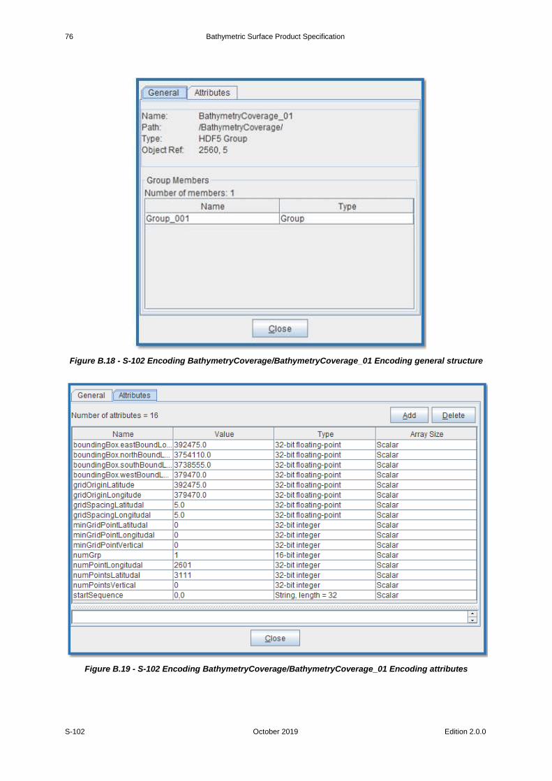
76 Bathymetric Surface Product Specification
S-102 October 2019 Edition 2.0.0
Figure B.18 - S-102 Encoding BathymetryCoverage/BathymetryCoverage_01 Encoding general structure
Figure B.19 - S-102 Encoding BathymetryCoverage/BathymetryCoverage_01 Encoding attributes
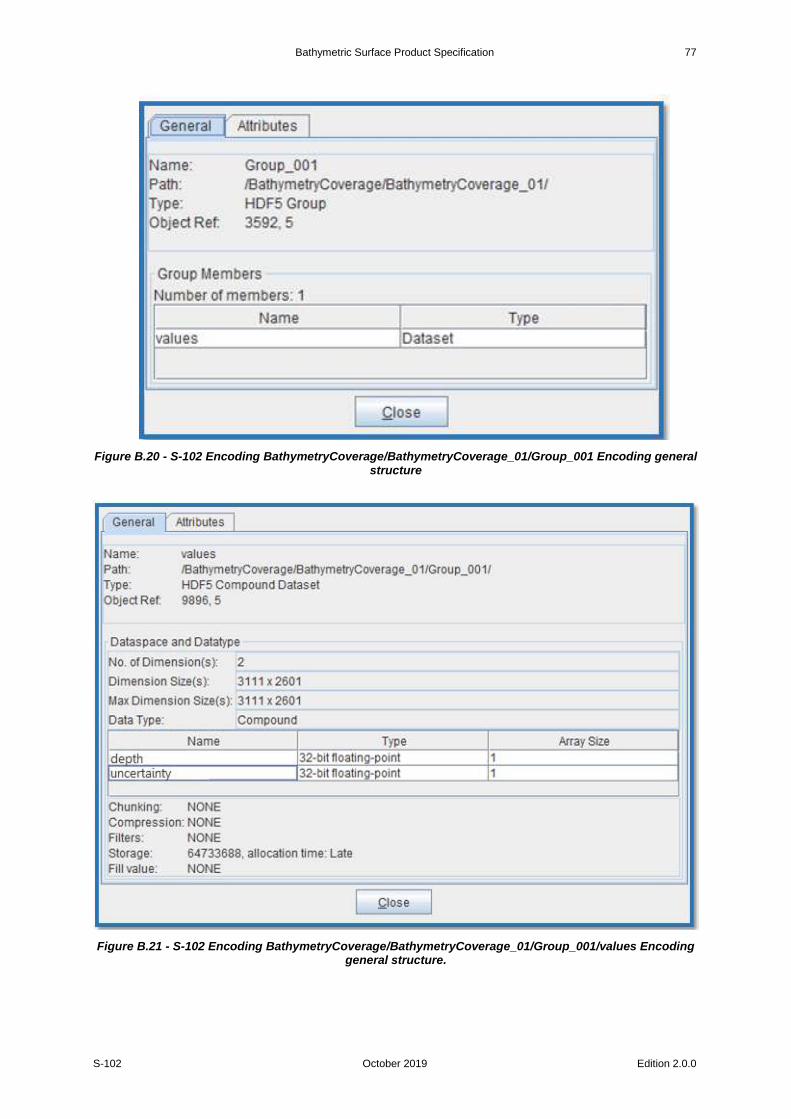
Bathymetric Surface Product Specification 77
S-102 October 2019 Edition 2.0.0
Figure B.20 - S-102 Encoding BathymetryCoverage/BathymetryCoverage_01/Group_001 Encoding general structure
Figure B.21 - S-102 Encoding BathymetryCoverage/BathymetryCoverage_01/Group_001/values Encoding general structure.
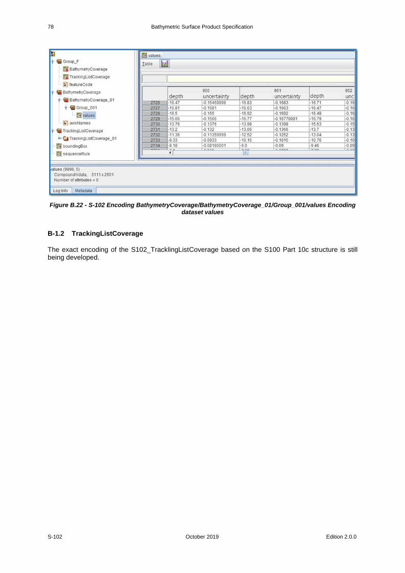
78 Bathymetric Surface Product Specification
S-102 October 2019 Edition 2.0.0
Figure B.22 - S-102 Encoding BathymetryCoverage/BathymetryCoverage_01/Group_001/values Encoding dataset values
B-1.2 TrackingListCoverage
The exact encoding of the S102_TracklingListCoverage based on the S100 Part 10c structure is still being developed.
Bathymetric Surface Product Specification 79
S-102 October 2019 Edition 2.0.0
Annex C. Normative Implementation Guidance
Normative Implementation Guidance to be addressed in a future version of S-102.

80 Bathymetric Surface Product Specification
S-102 October 2019 Edition 2.0.0
Page intentionally left blank

Bathymetric Surface Product Specification 81
S-102 October 2019 Edition 2.0.0
Annex D. Feature Catalogue
S-102 Feature Catalogue information is contained within a separate document: S-102FC_Ed2.0.0.docx.

82 Bathymetric Surface Product Specification
S-102 October 2019 Edition 2.0.0
Page intentionally left blank

Bathymetric Surface Product Specification 83
S-102 October 2019 Edition 2.0.0
Annex E. Portrayal Catalogue
Portrayal Catalogue currently under development.
84 Bathymetric Surface Product Specification
S-102 October 2019 Edition 2.0.0
Page intentionally left blank
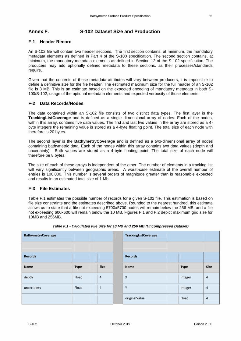
Bathymetric Surface Product Specification 85
S-102 October 2019 Edition 2.0.0
Annex F. S-102 Dataset Size and Production
F-1 Header Record
An S-102 file will contain two header sections. The first section contains, at minimum, the mandatory metadata elements as defined in Part 4 of the S-100 specification. The second section contains, at minimum, the mandatory metadata elements as defined in Section 12 of the S-102 specification. The producers may add optionally defined metadata to these sections, as their processes/standards require.
Given that the contents of these metadata attributes will vary between producers, it is impossible to define a definitive size for the file header. The estimated maximum size for the full header of an S-102 file is 3 MB. This is an estimate based on the expected encoding of mandatory metadata in both S-100/S-102, usage of the optional metadata elements and expected verbosity of those elements.
F-2 Data Records/Nodes
The data contained within an S-102 file consists of two distinct data types. The first layer is the TrackingListCoverage and is defined as a single dimensional array of nodes. Each of the nodes, within this array, contains five data values. The first and last two values in the array are stored as a 4-byte integers the remaining value is stored as a 4-byte floating point. The total size of each node with therefore is 20 bytes.
The second layer is the BathymetryCoverage and is defined as a two-dimensional array of nodes containing bathymetric data. Each of the nodes within this array contains two data values (depth and uncertainty). Both values are stored as a 4-byte floating point. The total size of each node will therefore be 8 bytes.
The size of each of these arrays is independent of the other. The number of elements in a tracking list will vary significantly between geographic areas. A worst-case estimate of the overall number of entries is 100,000. This number is several orders of magnitude greater than is reasonable expected and results in an estimated total size of 1 Mb.
F-3 File Estimates
Table F.1 estimates the possible number of records for a given S-102 file. This estimation is based on file size constraints and the estimates described above. Rounded to the nearest hundred, this estimate allows us to state that a file not exceeding 5700x5700 nodes will remain below the 256 MB, and a file not exceeding 600x600 will remain below the 10 MB. Figures F.1 and F.2 depict maximum grid size for 10MB and 256MB.
Table F.1 - Calculated File Size for 10 MB and 256 MB (Uncompressed Dataset)
BathymetryCoverage TrackingListCoverage
Records Records
Name Type Size Name Type Size
depth Float 4 X Integer 4
uncertainty Float 4 Y Integer 4
originalValue Float 4
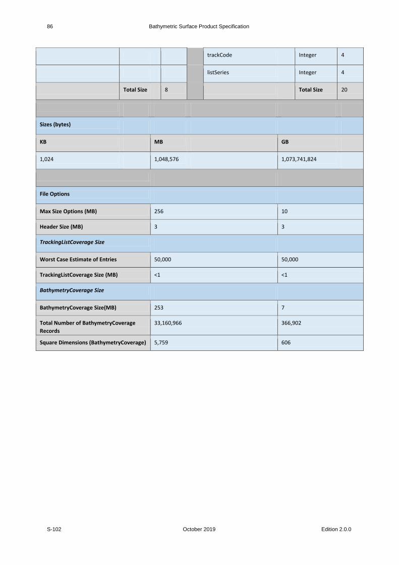
86 Bathymetric Surface Product Specification
S-102 October 2019 Edition 2.0.0
trackCode Integer 4
listSeries Integer 4
Total Size 8 Total Size 20
Sizes (bytes)
KB MB GB
1,024 1,048,576 1,073,741,824
File Options
Max Size Options (MB) 256 10
Header Size (MB) 3 3
TrackingListCoverage Size
Worst Case Estimate of Entries 50,000 50,000
TrackingListCoverage Size (MB) <1 <1
BathymetryCoverage Size
BathymetryCoverage Size(MB) 253 7
Total Number of BathymetryCoverage
Records
33,160,966 366,902
Square Dimensions (BathymetryCoverage) 5,759 606
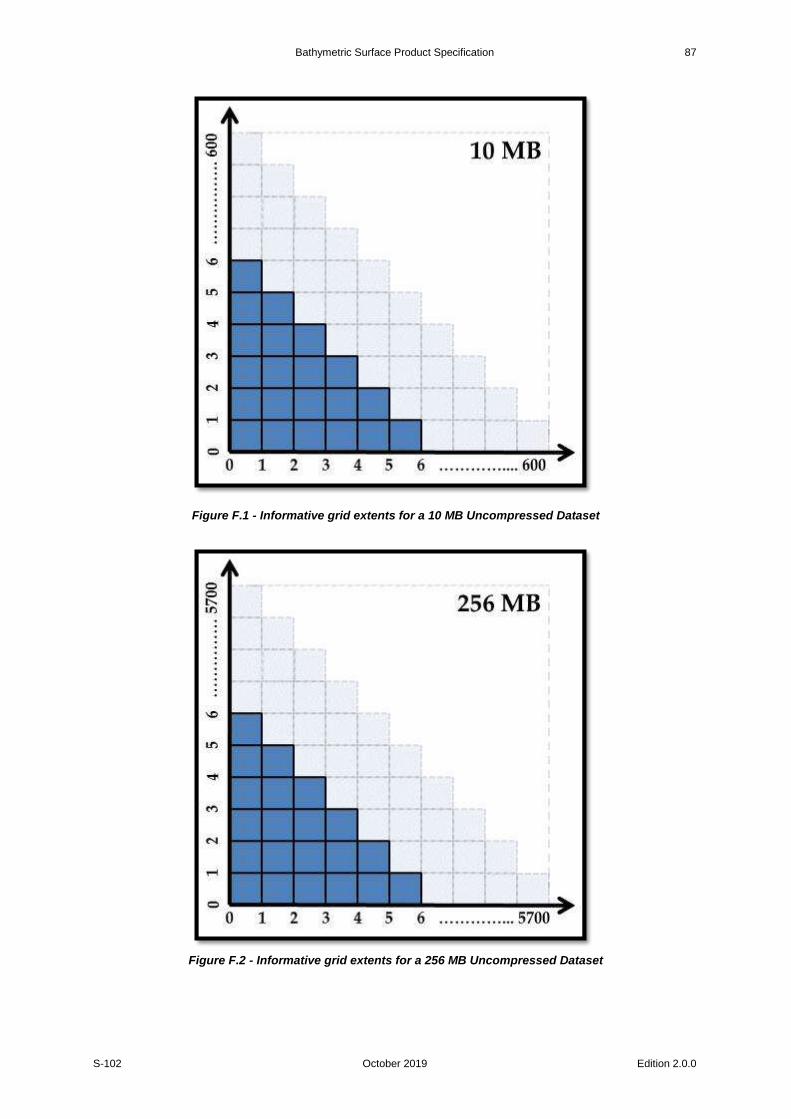
Bathymetric Surface Product Specification 87
S-102 October 2019 Edition 2.0.0
Figure F.1 - Informative grid extents for a 10 MB Uncompressed Dataset
Figure F.2 - Informative grid extents for a 256 MB Uncompressed Dataset

88 Bathymetric Surface Product Specification
S-102 October 2019 Edition 2.0.0
Page intentionally left blank
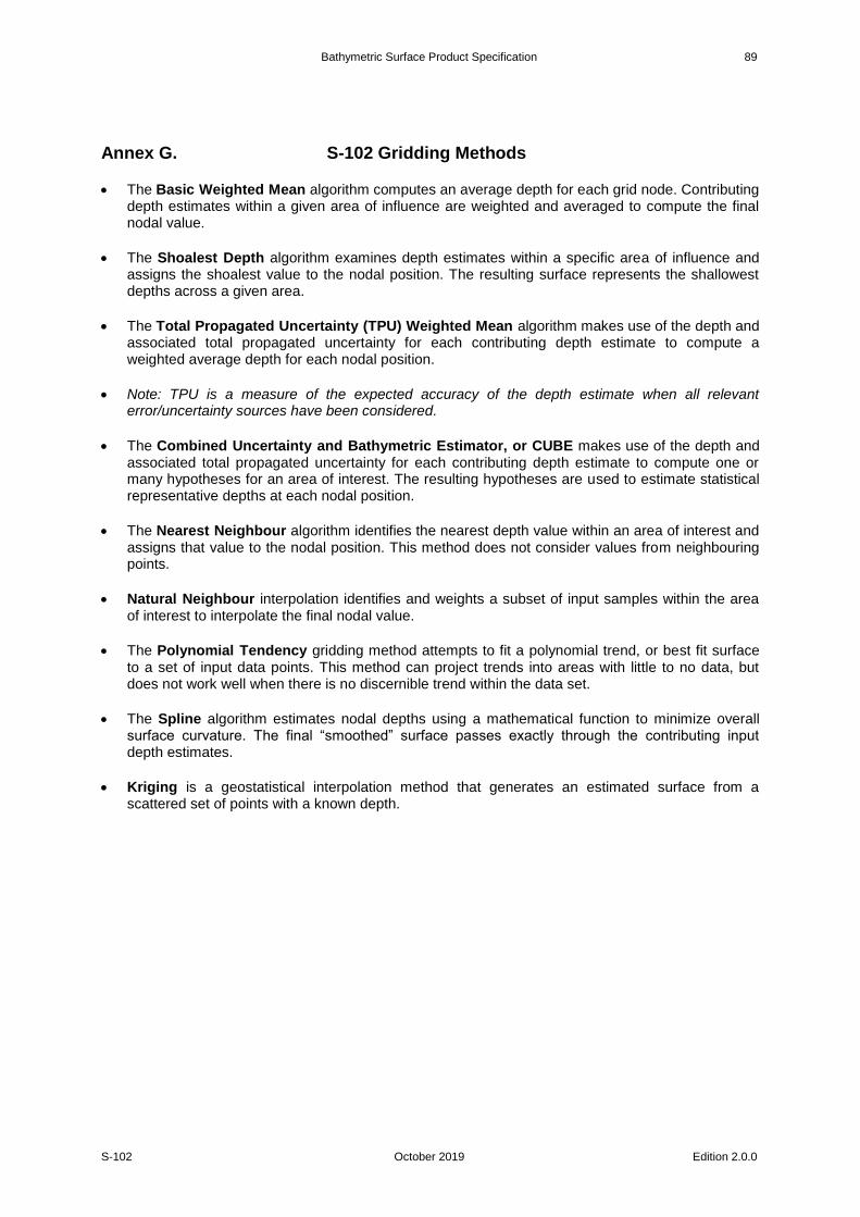
Bathymetric Surface Product Specification 89
S-102 October 2019 Edition 2.0.0
Annex G. S-102 Gridding Methods
The Basic Weighted Mean algorithm computes an average depth for each grid node. Contributing depth estimates within a given area of influence are weighted and averaged to compute the final nodal value.
The Shoalest Depth algorithm examines depth estimates within a specific area of influence and assigns the shoalest value to the nodal position. The resulting surface represents the shallowest depths across a given area.
The Total Propagated Uncertainty (TPU) Weighted Mean algorithm makes use of the depth and associated total propagated uncertainty for each contributing depth estimate to compute a weighted average depth for each nodal position.
Note: TPU is a measure of the expected accuracy of the depth estimate when all relevant error/uncertainty sources have been considered.
The Combined Uncertainty and Bathymetric Estimator, or CUBE makes use of the depth and associated total propagated uncertainty for each contributing depth estimate to compute one or many hypotheses for an area of interest. The resulting hypotheses are used to estimate statistical representative depths at each nodal position.
The Nearest Neighbour algorithm identifies the nearest depth value within an area of interest and assigns that value to the nodal position. This method does not consider values from neighbouring points.
Natural Neighbour interpolation identifies and weights a subset of input samples within the area of interest to interpolate the final nodal value.
The Polynomial Tendency gridding method attempts to fit a polynomial trend, or best fit surface to a set of input data points. This method can project trends into areas with little to no data, but does not work well when there is no discernible trend within the data set.
The Spline algorithm estimates nodal depths using a mathematical function to minimize overall surface curvature. The final “smoothed” surface passes exactly through the contributing input depth estimates.
Kriging is a geostatistical interpolation method that generates an estimated surface from a scattered set of points with a known depth.

90 Bathymetric Surface Product Specification
S-102 October 2019 Edition 2.0.0
Page intentionally left blank

Bathymetric Surface Product Specification 91
S-102 October 2019 Edition 2.0.0
Annex H. Multi-Resolution Gridding
Multi-Resolution gridding to be addressed in a future version of S-102.

92 Bathymetric Surface Product Specification
S-102 October 2019 Edition 2.0.0
Page intentionally left blank
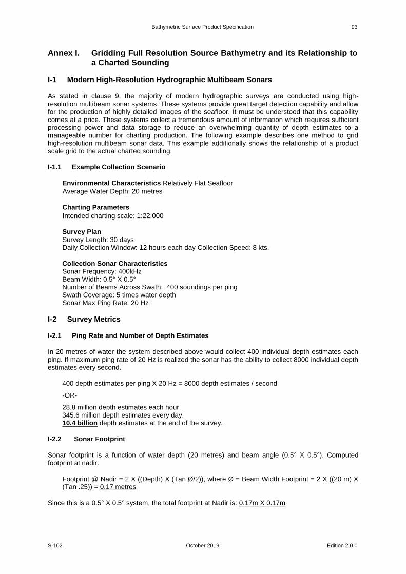
Bathymetric Surface Product Specification 93
S-102 October 2019 Edition 2.0.0
Annex I. Gridding Full Resolution Source Bathymetry and its Relationship to a Charted Sounding
I-1 Modern High-Resolution Hydrographic Multibeam Sonars
As stated in clause 9, the majority of modern hydrographic surveys are conducted using high-resolution multibeam sonar systems. These systems provide great target detection capability and allow for the production of highly detailed images of the seafloor. It must be understood that this capability comes at a price. These systems collect a tremendous amount of information which requires sufficient processing power and data storage to reduce an overwhelming quantity of depth estimates to a manageable number for charting production. The following example describes one method to grid high-resolution multibeam sonar data. This example additionally shows the relationship of a product scale grid to the actual charted sounding.
I-1.1 Example Collection Scenario
Environmental Characteristics Relatively Flat Seafloor
Average Water Depth: 20 metres
Charting Parameters
Intended charting scale: 1:22,000
Survey Plan Survey Length: 30 days Daily Collection Window: 12 hours each day Collection Speed: 8 kts.
Collection Sonar Characteristics Sonar Frequency: 400kHz Beam Width: 0.5° X 0.5° Number of Beams Across Swath: 400 soundings per ping Swath Coverage: 5 times water depth Sonar Max Ping Rate: 20 Hz
I-2 Survey Metrics
I-2.1 Ping Rate and Number of Depth Estimates
In 20 metres of water the system described above would collect 400 individual depth estimates each ping. If maximum ping rate of 20 Hz is realized the sonar has the ability to collect 8000 individual depth estimates every second.
400 depth estimates per ping X 20 Hz = 8000 depth estimates / second
-OR-
28.8 million depth estimates each hour. 345.6 million depth estimates every day. 10.4 billion depth estimates at the end of the survey.
I-2.2 Sonar Footprint
Sonar footprint is a function of water depth (20 metres) and beam angle (0.5° X 0.5°). Computed footprint at nadir:
Footprint @ Nadir = 2 X ((Depth) X (Tan Ø/2)), where Ø = Beam Width Footprint = 2 X ((20 m) X (Tan .25)) = 0.17 metres
Since this is a 0.5° X 0.5° system, the total footprint at Nadir is: 0.17m X 0.17m
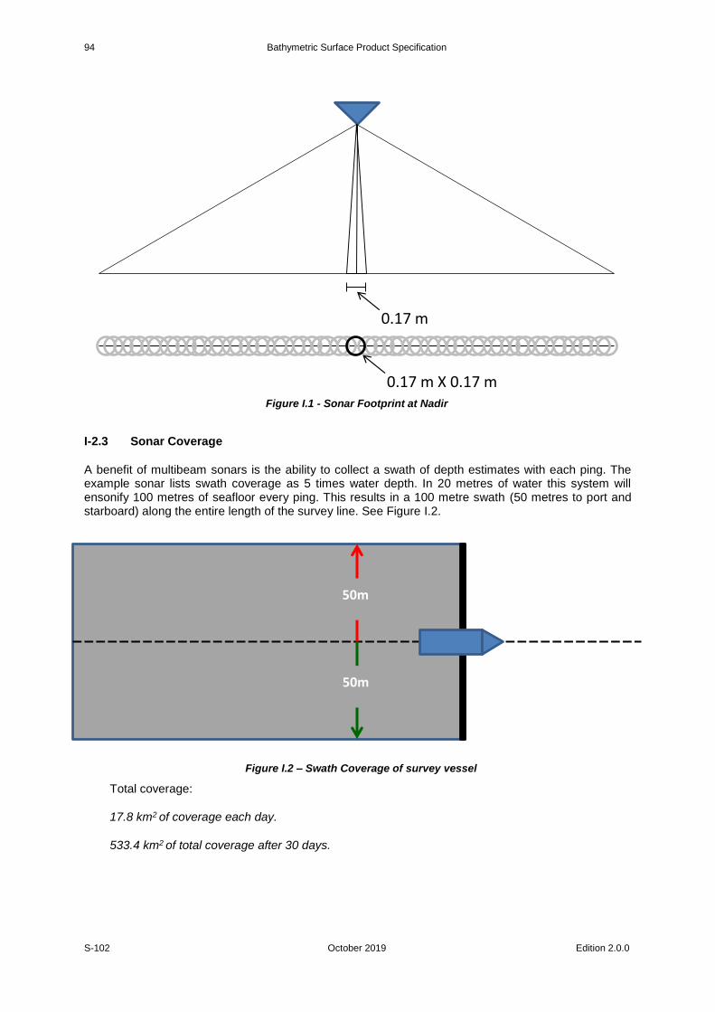
94 Bathymetric Surface Product Specification
S-102 October 2019 Edition 2.0.0
Figure I.1 - Sonar Footprint at Nadir
I-2.3 Sonar Coverage
A benefit of multibeam sonars is the ability to collect a swath of depth estimates with each ping. The example sonar lists swath coverage as 5 times water depth. In 20 metres of water this system will ensonify 100 metres of seafloor every ping. This results in a 100 metre swath (50 metres to port and starboard) along the entire length of the survey line. See Figure I.2.
Figure I.2 – Swath Coverage of survey vessel
Total coverage:
17.8 km2 of coverage each day.
533.4 km2 of total coverage after 30 days.
0.17 m
0.17 m X 0.17 m
50 m
50 m
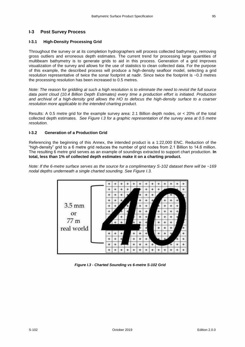
Bathymetric Surface Product Specification 95
S-102 October 2019 Edition 2.0.0
I-3 Post Survey Process
I-3.1 High-Density Processing Grid
Throughout the survey or at its completion hydrographers will process collected bathymetry, removing gross outliers and erroneous depth estimates. The current trend for processing large quantities of multibeam bathymetry is to generate grids to aid in this process. Generation of a grid improves visualization of the survey and allows for the use of statistics to clean collected data. For the purpose of this example, the described process will produce a high-density seafloor model, selecting a grid resolution representative of twice the sonar footprint at nadir. Since twice the footprint is ~0.3 metres the processing resolution has been increased to 0.5 metres.
Note: The reason for gridding at such a high resolution is to eliminate the need to revisit the full source data point cloud (10.4 Billion Depth Estimates) every time a production effort is initiated. Production and archival of a high-density grid allows the HO to defocus the high-density surface to a coarser resolution more applicable to the intended charting product.
Results: A 0.5 metre grid for the example survey area: 2.1 Billion depth nodes, or < 20% of the total collected depth estimates. See Figure I.3 for a graphic representation of the survey area at 0.5 metre resolution.
I-3.2 Generation of a Production Grid
Referencing the beginning of this Annex, the intended product is a 1:22,000 ENC. Reduction of the “high-density” grid to a 6 metre grid reduces the number of grid nodes from 2.1 Billion to 14.6 million. The resulting 6 metre grid serves as an example of soundings extracted to support chart production. In total, less than 1% of collected depth estimates make it on a charting product.
Note: If the 6-metre surface serves as the source for a complimentary S-102 dataset there will be ~169 nodal depths underneath a single charted sounding. See Figure I.3.
Figure I.3 - Charted Sounding vs 6-metre S-102 Grid

96 Bathymetric Surface Product Specification
S-102 October 2019 Edition 2.0.0
Page intentionally left blank