Bath & North East Somerset Green Belt Review | Stage 1 … · examination. A final draft of the...
79
Bath & North East Somerset April 2013 Bath & North East Somerset Green Belt Review | Stage 1 Report
-
Upload
vuongthien -
Category
Documents
-
view
221 -
download
2
Transcript of Bath & North East Somerset Green Belt Review | Stage 1 … · examination. A final draft of the...

Bath & North East Somerset April 2013
Bath & North East Somerset Green Belt Review | Stage 1 Report

Bath & North East Somerset
Green Belt Review
Stage 1 Report
4-05
Issue | April 2013
This report takes into account the particular
instructions and requirements of our client.
It is not intended for and should not be relied
upon by any third party and no responsibility
is undertaken to any third party.
Job number 228371
Ove Arup & Partners Ltd
63 St Thomas Street
Bristol BS1 6JZ
United Kingdom
www.arup.com


Bath & North East Somerset Green Belt ReviewStage 1 Report
4-05 | Issue | April 2013
GBR_STAGE1_REPORT_ISSUE_2013-04-23.DOCX
Contents
Page
1 Introduction 1
1.1 Purpose of the Green Belt Review 1
1.2 Structure of the Green Belt Review 2
2 Context 4
2.1 Core Strategy Examination 4
2.2 National Planning Policy Framework (NPPF) (March 2012) 5
3 Methodology 7
4 Green Belt history and policy origins 9
4.1 Introduction 9
4.2 Origins of Green Belt policy in England 10
4.3 Establishment of the Bristol and Bath Green Belt 10
4.4 Early alterations to the Green Belt in Bath & North East Somerset 12
4.5 Policy in the 1980s and 1990s 12
4.6 Regional Planning Guidance (2001) and the Joint Replacement Structure Plan (2002) 13
4.7 Bath and North East Somerset Local Plan (2007) 14
4.8 The South West Regional Spatial Strategy and West of England Joint Study Area 15
5 Green Belt appraisal criteria 16
5.1 Land parcels 16
5.2 Primary criteria 16
5.3 Secondary criteria 17
5.4 Comparison with SWRA Green Belt Review 19
6 Green Belt appraisal 20
6.1 West of Keynsham 20
6.2 South and east of Keynsham 30
6.3 Saltford and west of Bath 38
6.4 Around Bath 47
6.5 Southern Green Belt 56
7 Summary and Conclusions 62
Appendices

Bath & North East Somerset Green Belt ReviewStage 1 Report
4-05 | Issue | April 2013
GBR_STAGE1_REPORT_ISSUE_2013-04-23.DOCX
Appendix A
Maps
A1 Green Belt Land Parcels
A2 Green Belt Summary Map

Bath & North East Somerset Green Belt ReviewStage 1 Report
4-05 | Issue | April 2013
GBR_STAGE1_REPORT_ISSUE_2013-04-23.DOCX
Page 1
1 Introduction
Arup were appointed by Bath and North East Somerset (B&NES) to prepare a Green Belt Review as part of the evidence base informing the Core Strategy examination. A final draft of the Green Belt Review Stage 1 Report (February 2013) was prepared to inform Council decisions on Proposed Changes to the Submitted Core Strategy and the report has now been finalised for the examination.
Two further elements of Green Belt Review work are on-going:
• As resolved at the meeting of full Council on 4th
March 2013, the Council is in the process of considering whether additions to the Green Belt should be proposed. Appraisals of land that fall outside the Green Belt designation are being progressed to inform this decision and discussion at the Examination Hearings when they are re-convened.
• A Stage 2 Green Belt Review report will focus on the specific areas of land where Green Belt releases or additions are proposed, providing recommendations on detailed boundary changes.
This Green Belt Review supersedes the Strategic Green Belt Review undertaken for the South West Regional Assembly (Colin Buchanan, February 2006), which was formally submitted as Core Strategy evidence by B&NES – Core Documents CD3/16 and CD3/17 .
1.1 Purpose of the Green Belt Review
In June 2011 the Planning Inspector published ‘Preliminary Conclusions on Strategic Matters and Way Forward’ (ID/28) in relation to the B&NES Core Strategy Examination. Principal concerns raised by the Inspector included the current lack of a National Planning Policy Framework (NPPF) compliant assessment of the housing requirement and a potential shortfall in housing land supply. On the basis that it may prove necessary for the Council to identify further areas of land suitable for development, the Inspector also drew attention to the absence of a robust Green Belt review:
“There is no up-to date and comprehensive review of the Green Belt in the district to see whether all the land so designated fulfils clear Green Belt purposes; the degree of significance which should be attached to various parts of the Green Belt; or the extent to which some development in the Green Belt would promote sustainable development.” (paragraph 4.3)
The Inspector therefore recommended that, subject to the outcomes of further housing supply work, evidence base work undertaken by B&NES should involve a “…review of the Green Belt’s capacity to accommodate further development in a sustainable manner” (paragraph 7).
This study seeks to fulfil three of the four objectives set out in the Inspector’s recommendations for a Green Belt review:
A comprehensive review – the study covers the full area of the Green Belt designation within the B&NES administrative area.

Bath & North East Somerset Green Belt ReviewStage 1 Report
4-05 | Issue | April 2013
GBR_STAGE1_REPORT_ISSUE_2013-04-23.DOCX
Page 2
Does all land serve Green Belt purposes – the study concludes that all parts of the Green Belt serve at least one of the five Green Belt “purposes” set out in the NPPF.
Significance which should be attached to various parts of the Green Belt – the Green Belt Review has been undertaken in the context that it may be necessary to release land for development and therefore the appraisal criteria used seek to distinguish the relative value of different parcels of land in Green Belt terms. This is done by:
• Firstly, assessing whether an area of land serves each of the five Green Belt purposes set out in the NPPF; and
• Secondly, by seeking to differentiate whether an area of land is of greater or lesser importance in fulfilling each of those purposes. The importance of land in fulfilling each of the five purposes and the weight attached to each purpose are judgements which are undertaken within the context of and informed by the original reasons for the designation of the Bristol and Bath Green Belt.
• Thirdly, consideration is given to the extent to which land fulfils the sixth local purpose of preserving the individual character, identify and setting of villages and hamlets (Local Plan 2007, Table 10).
Importantly, the Green Belt Review has been undertaken independently of the Sustainability Appraisal and other evidence base work assessing potential development options and therefore it does not set out recommendations on the “…extent to which some development in the Green Belt would promote sustainable development”. It was determined at the outset of the study that the Green Belt Review should not seek to balance Green Belt purposes with other sustainability objectives and that it is the role of the Council to undertake this task when considering and presenting changes to the Core Strategy.
This review covers only those parts of the Green Belt designation falling within the B&NES administrative area. Ideally a review of this type would be undertaken at a strategic level, covering all parts of the Bristol and Bath Green Belt. In the circumstances that the Core Strategy examination has been suspended for a limited period of time only and given the stages that neighbouring authorities Core Strategies are at, it has been necessary for B&NES to proceed with a review that covers its own area only. The draft methodology for the review was circulated to West of England authorities and the comments received have been taken into account as the study has progressed.
1.2 Structure of the Green Belt Review
The Green Belt Review report is structured as follows:
• Chapter 2 provides further information on the context for the study, including the recommendations of the Planning Inspector and current national policy set out in the NPPF.
• Chapter 3 sets out the methodology.
• Chapter 4 provides a summary of the origins and history of the Bristol and Bath Green Belt, including amendments that have been made since the original boundaries were approved by Central Government in 1966.

Bath & North East Somerset Green Belt ReviewStage 1 Report
4-05 | Issue | April 2013
GBR_STAGE1_REPORT_ISSUE_2013-04-23.DOCX
Page 3
• Chapter 5 sets out details of the appraisal criteria and other considerations used for the review.
• Chapter 6 provides the full appraisal tables for each land parcel within the Green Belt.
• Chapter 7 presents conclusions.

Bath & North East Somerset Green Belt ReviewStage 1 Report
4-05 | Issue | April 2013
GBR_STAGE1_REPORT_ISSUE_2013-04-23.DOCX
Page 4
2 Context
2.1 Core Strategy Examination
As set out in the introduction, in June 2011 the Planning Inspector published ‘Preliminary Conclusions on Strategic Matters and Way Forward’ (ID/28) in relation to the B&NES Core Strategy Examination. The Preliminary Conclusions sets out two proposed options for the Council of suspending the Examination to enable further work to be undertaken; or withdrawal of the Core Strategy entirely so that B&NES could focus on preparation of a Local Plan that incorporates site allocations.
The Inspector allowed the Council to suspend the Core Strategy examination while further evidence work is undertaken to address the matters raised. Linked to the availability of housing land and the potential need to allocate more areas of land for development, the Inspector’s Preliminary Conclusions on the Core Strategy refer to the need for a “a review of the Green Belt’s capacity to accommodate further development in a sustainable manner.”
The Bristol and Bath Green Belt extends across over 70% of the B&NES area (approximately 25,000 hectares) and, pending the exhaustion of remaining infill and brownfield sites in existing settlements, severely restricts the potential for strategic housing development to meet demands arising in a sustainable way.
In addition to setting out guidance on the scope of a Green Belt Review (see Introduction), the Inspector provides further advice that will be of importance as the Council considers updates to the spatial strategy:
Figure 1 - General Extent of the Green Belt in Bath & North East Somerset
(source: B&NES Local Plan, Diagram 8)

Bath & North East Somerset Green Belt ReviewStage 1 Report
4-05 | Issue | April 2013
GBR_STAGE1_REPORT_ISSUE_2013-04-23.DOCX
Page 5
• Firstly, the Inspector makes it clear that the Green Belt designation is not sacrosanct, stating that: “Whilst the NPPF reiterates the great importance of Green Belt, it envisages Green Belt boundaries being altered where necessary as part of the review of Local Plans” (paragraph 4.2).
• Secondly, with reference to land along the river corridor at Bath, the Inspector states: “…the fact that the Green Belt housing sites would be sequentially preferable in terms of flood risk needs to be weighed in the balance in any re-assessment by the Council” (paragraph 3.12). This gives an indication of the comparative weight of Flood Risk and Green Belt policy.
• Thirdly, in the context of the Council’s overall spatial strategy, the approach to Keynsham of increased self-containment was considered to be sound. However, the Inspector suggested that if additional housing land is required this approach could be eased, which would require land to be released from the Green Belt (paragraph 3.36). Keynsham lies within the strategic gap between Bristol and Bath which is protected by the Green Belt. The Green Belt around Keynsham plays a particularly important role in preventing coalescence of the town with Bristol and needs to be carefully and objectively assessed.
• Finally, the Inspector advises that the NPPF does not make a 15 year plan timeframe a requirement, but a longer term perspective of housing delivery will be particularly important if there needs to be a review of the Green Belt (paragraph 2.20). A Green Belt Review should look to the end of the Core Strategy period and beyond with the aim of ensuring the “permanence” of any revised boundaries.
2.2 National Planning Policy Framework (NPPF) (March 2012)
This review has been undertaken in conformance with policy and guidance set out in the NPPF, which states:
“The fundamental aim of Green Belt policy is to prevent urban sprawl by keeping land permanently open; the essential characteristics of Green Belts are their openness and permanence.
Green Belt serves five purposes:
• to check the unrestricted sprawl of large built-up areas;
• to prevent neighbouring towns merging into one another;
• to assist in safeguarding the countryside from encroachment;
• to preserve the setting and special character of historic towns; and
• to assist in urban regeneration, by encouraging the recycling of derelict and other urban land” (Paragraphs 79 & 80).
These five statutory purposes of the Green Belt form the basis for the primary appraisal criteria set out in chapter 5 of this report.
Further important elements of policy and guidance in the NPPF cover: the intended permanence of the Green Belt; the need to take account of sustainable patterns of development; the advice that the Green Belt should only be altered in exceptional circumstances; and positive planning for use of land in the Green

Bath & North East Somerset Green Belt ReviewStage 1 Report
4-05 | Issue | April 2013
GBR_STAGE1_REPORT_ISSUE_2013-04-23.DOCX
Page 6
Belt. These points are considered here, while references are made to other elements of NPPF policy where appropriate throughout this report.
Permanence of Green Belts – The NPPF states that the permanence of Green Belts is an essential characteristic (paragraph 79) and advises that, “once established, Green Belt boundaries should only be altered in exceptional circumstances, through the preparation or review of the Local Plan. At that time, authorities should consider the Green Belt boundaries having regard to their intended permanence in the long term, so that they should be capable of enduring beyond the plan period” (paragraph 83). The Bristol and Bath Green Belt has remained predominantly intact since it was approved in 1966, although some revisions have been deemed necessary during the preparation of subsequent plans (see chapter 4). As set out in the NPPF, production of the new B&NES Core Strategy is the appropriate time to consider whether exceptional circumstances have arisen that warrant alterations to the general extent of the Green Belt. If this is found to be the case, the Council should consider alterations with a very long timescale in mind to limit the risk of ad hoc alterations being required during and beyond the Core Strategy period.
Sustainable patterns of development – NPPF policy intimates that protection of the Green Belt must be balanced with other sustainable development considerations during the preparation of the Core Strategy: “When drawing up or reviewing Green Belt boundaries local planning authorities should take account of the need to promote sustainable patterns of development. They should consider the consequences for sustainable development of channelling development towards urban areas inside the Green Belt boundary, towards towns and villages inset within the Green Belt or towards locations beyond the outer Green Belt boundary” (paragraph 84). This study does take account of some wider sustainable development matters, including accessibility, biodiversity, access and heritage matters, but only at a basic level of detail. The Green Belt Review therefore forms only part of the evidence base, alongside the Sustainability Appraisal, that must be considered by the Council.
Demonstrating “exceptional circumstances” – Paragraph 83 of the NPPF states that “once established, Green Belt boundaries should only be altered in exceptional circumstances.” The Inspector indicates that a review of housing figures and consideration of how this can be met sustainably may provide the justification for the release of Green Belt land in the B&NES administrative area.
Promoting positive use of the Green Belt - Once Green Belts are defined, Local Planning Authorities are encouraged to plan positively to enhance the beneficial use of the Green Belt, such as “looking for opportunities to provide access; to provide opportunities for outdoor sport and recreation; to retain and enhance landscapes, visual amenity and biodiversity; or to improve damaged and derelict land” (paragraph 82). In order to provide B&NES Members and officers with information about positive uses in the Green Belt to aid planning and decision making, a series of secondary criteria are presented in chapter 5 and utilised in the appraisal. These should not, however, be confused with the five primary purposes of the Green Belt presented above.

Bath & North East Somerset Green Belt ReviewStage 1 Report
4-05 | Issue | April 2013
GBR_STAGE1_REPORT_ISSUE_2013-04-23.DOCX
Page 7
3 Methodology
The Green Belt Review is expected to comprise a two stage process, with the publication of this report marking the completion of Stage 1:
• Stage 1 – Completion of a high level, district wide Green Belt review to ascertain the extent to which different parcels of land serve national Green Belt purposes, with reference also to the local reasons for the Bristol and Bath Green Belt designation. This work will inform any update to the Core Strategy by B&NES and potentially the identification of broad areas for Green Belt releases or additions.
• Stage 2 – Should the Council determine that alterations to the Green Belt boundary are necessary, a second stage of more detailed area based studies would be undertaken. This would inform detailed boundary changes that may be consulted upon through the preparation of a Site Allocations Plan document (Placemaking Plan).
The steps taken to complete the Stage 1 Green Belt Review are summarised in Figure 2.
There is no statutory guidance on how a Green Belt Review should be undertaken and therefore the methodology has been informed by consideration of the Green Belt studies undertaken elsewhere, previous Bristol and Bath Green Belt Review work (Buchanan Study and West of England Green Belt Reviews – Core Strategy Examination Core Documents CD3/16 &17) and discussions with B&NES officers.

Bath & North East Somerset Green Belt ReviewStage 1 Report
4-05 | Issue | April 2013
GBR_STAGE1_REPORT_ISSUE_2013-04-23.DOCX
Page 8
Step 1
Green Belt history
It is helpful to set the context for the current review by
presenting when the Green Belt was first designated and the
extent of subsequent changes (see chapter 4).
Step 2 Establish land parcels
It was agreed with B&NES Officers that the land parcels
defined for the Sustainability Appraisal should be used to
facilitate cross-referencing between the two studies. Three
further land parcels were established covering the south of
the District (see chapter 5).
Step 3 Establish appraisal
criteria
Primary criteria covering the five statutory Green Belt
purposes and secondary criteria covering positive uses of the
Green Belt were agreed with B&NES Officers. A sixth local
purpose was also identified (see Chapter 5 for details).
Step 4 Green Belt appraisal
Desk-based draft appraisals of Green Belt land parcels were
undertaken using the agreed criteria (see Chapter 6 for
results).
Step 5 Green Belt Review
Workshop
A workshop was held with B&NES Officers to allow for
critical discussion of results, resulting in updates to the
appraisal (see Chapter 6 for results).
Step 6 Cross-check with
2006 Strategic Green Belt Review
Results of Green Belt appraisal were cross-checked against
the conclusions of the Buchanan West of England Green Belt
Review 2006 to understand whether any different views have
arisen, and if so why.
Figure 2 - Green Belt Review steps

Bath & North East Somerset Green Belt ReviewStage 1 Report
4-05 | Issue | April 2013
GBR_STAGE1_REPORT_ISSUE_2013-04-23.DOCX
Page 9
4 Green Belt history and policy origins
4.1 Introduction
Judgements made by B&NES on the future of the Green Belt must be based, first and foremost, on planning imperatives for the Core Strategy (as set out elsewhere in the evidence base) and current national policy set out in the NPPF. In seeking to establish “…the degree of significance which should be attached to various parts of the Green Belt” (ID/28, paragraph 4.3), it is also necessary to have an appreciation of the history of the Bristol and Bath Green Belt, the original intentions of the designation when it was prepared at the local level and the extent of previous changes. To assist decision-makers, the appraisal criteria have been developed to present matters of both national and local importance.
The Bristol and Bath Green Belt designation was established through the preparation of the Gloucestershire, Somerset and Wiltshire County Development Plans by local planning authorities in the late 1950s and approved by the Government Minister in 1966. The county plans made an allowance for substantial development on ‘white land’ between the urban edges of Bristol and Bath and the inner Green Belt boundary. This has meant that the original designation has endured well over the decades, although subsequent development plans have resulted in both releases and additions to the Green Belt as summarised here:
• 1973 Addition 1, Bath – enlargement of the Green Belt around Bath.
• 1975 Addition 2, Clevedon - Land was added between Portishead and Clevedon.
• 1970s -1980s, Release 1, Emerson’s Green - Land was taken out of the Green Belt immediately South of the M4 in the Bradley Stoke and Emerson’s Green areas.
• 1980s - Addition 3, southern boundary - General extent of Green Belt extended southwards (south of Farmborough and north of Clutton, High Littleton, Timsbury and Peasedown) by Avon County Structure Plan Alteration
• 1990 – The Bath City Plan resulted in amendments to the inner Green Belt boundary to allow for small additional amounts of development land.
• 2002 Addition 4, Royal Portbury Dock - An extension to the Green Belt is proposed in order to prevent the coalescence of Royal Portbury Dock with Portishead.
• 2002 & 2007 Release 2, Keynsham – As required by the Joint Replacement Structure Plan (2002), the B&NES Local Plan (2007) provided for the release of land for residential development at Keynsham.
• 2007 Release 3, Bath University, Claverton Down - exceptional circumstances were established which warranted the release of Green Belt land for the development of higher education opportunities.
More recently, the potential for several substantial alterations to the Green Belt boundary were proposed in the Draft Regional Spatial Strategy (RSS), and the Proposed Changes to the Draft RSS to enable the development of urban extensions at Bristol, Bath and Keynsham. This study supercedes, but

Bath & North East Somerset Green Belt ReviewStage 1 Report
4-05 | Issue | April 2013
GBR_STAGE1_REPORT_ISSUE_2013-04-23.DOCX
Page 10
incorporates cross-checks with the Strategic Green Belt Review (Buchanan for SWRA, 2006).
This chapter is not a detailed history, but is intended to provide an overview of the Green Belt, from the factors that influenced the original boundaries of the designation through to the changes proposed by the Draft RSS.
4.2 Origins of Green Belt policy in England
4.2.1 The London Green Belt
The first Green Belt in England was proposed in official planning policy by the Greater London Planning Committee in 1935, subsequently the Green Belt London and Home Counties Act was produced in 1938. This act provided the starting point for the definition of what land uses are appropriate in a Green Belt and a ‘Green Belt Ring’ was implemented around London through the 1944 Greater London Plan.
4.2.2 Circular 42/54
After the Second World War the 1947 Town and Country Planning Act was introduced, which allowed authorities to control the use of land. Then in 1955 the government published Circular 42/55 ‘Green Belts’ inviting local authorities to consider the establishment of Green Belts.
The Circular draws attention to the importance of checking the unrestricted sprawl of urban areas and safeguarding the surrounding countryside from further encroachment. The circular recommends Planning Authorities establish a Green Belt wherever this is desirable in order to:
(a) check the further growth of a large built-up area;
(b) prevent neighbouring towns from merging into one another; or
(c) preserve the special character of a town
Circular 42/55 states that “wherever practical a Green Belt should be several miles wide and that inside a Green Belt, approval should not be given except in very special circumstances for the construction of new buildings.” It is apparent that the overarching aims of Green Belt policy have changed very little since the Circular was published in 1955 and the NPPF was approved in 2012.
4.3 Establishment of the Bristol and Bath Green Belt
The Bristol and Bath Green Belt was broadly established in the mid-1950s through the Gloucestershire, Somerset and Wiltshire County Development Plans. The majority of the Bristol and Bath Green Belt fell within the Somerset authority area and the Green Belt designation was locally adopted in 1957 and then approved in 1966 by the Government Minister.

Bath & North East Somerset Green Belt ReviewStage 1 Report
4-05 | Issue | April 2013
GBR_STAGE1_REPORT_ISSUE_2013-04-23.DOCX
Page 11
When determining the extent of a Green Belt designation, the stated intentions of
the Local Planning Authority were1:
• “…to prevent the merger of Bristol, Keynsham, Saltford and Bath;”
• “…to preserve the identity and existing character of the towns, villages and hamlets within the green belt;”
• “…not to agree to further growth around the cities of Bristol and Bath within the area proposed to be covered by Green Belt;” and
• “…to limit development generally to that necessary for the continued vitality of the countryside and villages therein.”
In deciding the general extent of the Green Belt the local planning authority had
regard to the following general factors:
1. The areas where pressure for building development has been greatest.
2. The Minister’s advice that the Green Belt should be several miles wide.
3. The approved Town Maps for the environs of Bristol and Bath.
4. The provisions of the County Development Plan relating to areas of great landscape value.
5. Topographical features.
6. That there should be a continuous Green Belt across the northern part of the County rather than separate Green Belts around Bristol and Bath.
7. Necessity to co-ordinate with other authorities.
8. Local knowledge and opinions of the County District Councils concerned.
With respect to ‘3’ above, the Minister had approved Town Maps which define the limits of development for the following places:
(i) Within the Bristol Environs (South West) Town Map:
• Abbots Leigh • Failand (Sixty Acres) • Long Ashton • Part of Barrow Gurney • Dundry
(ii) Within the Bristol Environs (South East) Town Map:
• Whitchurch • Keynsham • Saltford
(iii) Within the Bath Environs Town Map:
• Corston • Lower Swainswick and Bailbrook • Batheaston • Bathford • Bathampton
1 Source: Somerset County Council ‘County Development Plan Report of Survey relating to
Bristol and Bath Green Belt’ (not dated).

Bath & North East Somerset Green Belt ReviewStage 1 Report
4-05 | Issue | April 2013
GBR_STAGE1_REPORT_ISSUE_2013-04-23.DOCX
Page 12
• Combe Down • Monkton Combe
The Planning Authority considered that some limited expansion beyond the plan period was necessary in certain places and therefore the authority left some land unallocated (‘white land’) between the existing development areas and the Green Belt. In order to avoid amendments to the Green Belt white areas were shown at Whitchurch, Keynsham, Saltford, Corston, Batheaston, Bathford, Bathampton, Combe Down and Monkton Combe.
The implementation of the Green Belt resulted in local planning authorities guiding development to settlements beyond the Bristol and Bath Green Belt such as Thornbury, Yate, Nailsea, Portishead and Congresbury.
It is apparent from the stated intentions for the Green Belt that the County Councils placed great emphasis on preserving the identity and existing character of the towns, villages and hamlets within the Green Belt, as well as the overall aim of checking the growth of Bristol and Bath and preventing the merger of the two cities.
4.4 Early alterations to the Green Belt in Bath & North East Somerset
A number of significant changes to the Bristol and Bath Green Belt were agreed in the 1970s and 1980s, which included both releases and additions to the Green Belt. In 1973 the City of Bath approved an enlargement of the Green Belt around Bath covering thirteen areas on the edge of the built-up area, but within the city boundary.
4.5 Policy in the 1980s and 1990s
The importance of the Green Belt designation was maintained through the 1980s, with policy evolving in the mid 1990s to acknowledge the importance of promoting “sustainable patterns of development”.
4.5.1 1985 Avon Structure Plan
The County of Avon Structure Plan (Adopted 1985) retained the Green Belt in Avon stating the objective to use the Green Belt: “as a means of directing the future pattern of growth and to assist in concentrating development within and on the fringe of Bath and Bristol without resulting in the coalescence of these urban areas or urban sprawl.”
The Structure Plan also included guidance for the Green Belt boundaries and within policy (GB.1) it states that the: “Bristol and Bath Green Belt is defined so as to provide a width between the inner and outer boundaries normally not less than about 8km.”
A County Structure Plan Alteration in the 1980s resulted in the third addition to the Green Belt, comprising the southwards extension of the designation (south of Farmborough and north of Clutton, High Littleton, Timsbury and Peasedown).

Bath & North East Somerset Green Belt ReviewStage 1 Report
4-05 | Issue | April 2013
GBR_STAGE1_REPORT_ISSUE_2013-04-23.DOCX
Page 13
4.5.2 Circular 14/84
In the mid-1980s the Government issued advice to Local Authorities in the form of Department of Environment (DoE) Circular 14/84. This Circular reinforced the Government’s commitment to Green Belts and placed emphasis on the importance and permanent nature of Green Belts.
Paragraph 3 of the Circular stated:
“…the essential characteristics of the Green Belt is their permanence and their protection must be maintained as far as can be seen ahead.”
And following on from this further stated:
“Once the general extent of a Green belt has been approved as part of the structure plan for an area it should be altered only in exceptional circumstances. If such an alteration is proposed the Secretary of State will wish to be satisfied that the authority has considered opportunities for development within the urban area contained by and beyond the Green Belt. Similarly, detailed Green Belt boundaries defined in adopted local plans or earlier approved development plans should be altered only exceptionally.”
4.5.3 The City Plan: The Local Plan for the City of Bath
(1990)
In the City Plan the inner Green Belt boundary was ‘pushed back’ in certain areas to allow small additional amounts of future development land.
4.5.4 Planning Policy Guidance Notes
In 1988 Circular 42/55 was replaced with Planning Policy Guidance Note 2 (PPG2). Then in 1995 PPG2 was amended to add positive objectives for Green Belts, such as to provide opportunities for access to the open countryside for the urban population, provide opportunities for outdoor sport and outdoor recreation near urban areas, and to retain attractive landscapes and enhance landscapes near to where people live. PPG2 also identified the need for Local Planning Authorities to promote sustainable patterns of development.
PPG2 1995 states “When drawing Green Belt boundaries in development plans
local planning authorities should take account of the need to promote sustainable
patterns of development.”
National Guidance in the form of PPG3 (Housing) issued in 2000, stated that there may be a case for reviewing green belt boundaries to allow the development of urban extensions where this would be the most sustainable of the available options. Draft revised guidance (PPS3) was published in December 2005.
4.6 Regional Planning Guidance (2001) and the Joint Replacement Structure Plan (2002)
Regional guidance (RPG10), published in 2001, stated that a review of the Bristol
and Bath Green Belt should be undertaken, to examine whether alterations of the

Bath & North East Somerset Green Belt ReviewStage 1 Report
4-05 | Issue | April 2013
GBR_STAGE1_REPORT_ISSUE_2013-04-23.DOCX
Page 14
inner and outer boundaries are needed to allow for long term sustainable
development needs:
“Policy SS 4: Green Belt in the region should continue to fulfil the purposes set
out in PPG2. As a key element of the future planning of the region, local
authorities when preparing their development plans should:
• critically review the Green Belt to examine whether boundary alterations are
needed to allow for long term sustainable development needs;
• remove land from the Green Belt for development if, on balance, this would
provide the most sustainable solution for accommodating future development
requirements;
• include additional land within the Green Belt where clearly necessary for the
purposes set out in PPG2.”
RPG10 states: “The purposes of Green Belt policy (as set out in PPG2) remain an
essential part of RPG for the South West. However, the need to ensure that future
patterns of development are more sustainable means that the boundaries of these
Green Belts should be reviewed in the next round of structure plans.”
The Bath & North East Somerset, Bristol, North Somerset and South Gloucestershire Joint Replacement Structure Plan (JRSP)(Adopted 2002) set out the broad planning policy framework for the former Avon County area up to the year 2011. The Green Belt which covers some 47% of the structure plan area was a key element of the locational strategy.
The JRSP advised: “The strategy set out in this Plan allows development within the period to be accommodated firstly within or immediately adjoining the major urban areas, or secondly at settlements beyond the Green Belt with good public transport, but in all cases outside the Green Belt.”
The JRSP set out alterations to the extent of the Green Belt only between
Portishead and Royal Portbury Dock, and at Keynsham, where it states there are
“exceptional circumstances” and good planning reasons that justify the change:
• Addition 1 - An extension to the Green Belt is proposed in order to prevent the coalescence of Royal Portbury Dock with Portishead.
• Alteration 1 - At Keynsham, the Local Plan should take land out of the Green Belt in order to provide primarily for housing, with some associated local employment and social infrastructure (detailed boundary of the alteration confirmed in the 2007 Local Plan please see section below).
4.7 Bath and North East Somerset Local Plan (2007)
The Local Plan Adopted 2007 set out the six purposes for including land in the Green Belt within B&NES which predominantly reflects the five Green Belt purposes set out in PPG2 (and since in the NPPF). The local importance of preserving the setting of smaller settlements within the Bristol-Bath Green Belt is reinforced through the inclusion of the sixth purpose, a reflection of the original intention of the local planning authority when the Green Belt boundaries were established in the 1950s:

Bath & North East Somerset Green Belt ReviewStage 1 Report
4-05 | Issue | April 2013
GBR_STAGE1_REPORT_ISSUE_2013-04-23.DOCX
Page 15
1. To check the unrestricted sprawl of Bath and Bristol.
2. To prevent the merging of Bristol, Keynsham, Saltford and Bath.
3. To assist in safeguarding the countryside from encroachment.
4. To preserve the setting and special character of Bath.
5. To assist in urban regeneration of Bath and Bristol by encouraging the
recycling of derelict and other urban land.
6. To preserve the individual character, identity and setting of Keynsham and the
villages and hamlets within the Green Belt.
These six purposes are also included in the Draft Core Strategy that was submitted for Examination in 2011.
Within the strategic context of the Joint Structure Plan, the Local Plan reproduced
the detailed boundaries of the Green Belt and included changes at two locations:
• Keynsham, changes to be made in order to provide primarily for new
residential development (boundary to be altered to exclude land on the
south western side of the town).
• Claverton Down (Bath University), exceptional circumstances established
which warranted excluding these areas for the priority goal for the
development of higher education opportunities.
4.8 The South West Regional Spatial Strategy and West of England Joint Study Area
The Draft Regional Spatial Strategy (DRSS) for the South West identified Bristol and Bath as Strategically Significant Cities or Towns (SSCTs) and therefore focal points for future growth within the region. Proposals set out in the DRSS included Areas of Search for urban extensions around the periphery of Bristol and a further Area of Search for an urban extension to the south west of Bath. Each of the proposed urban extensions would have necessitated revisions to the Green Belt boundary.
The West of England Partnership, comprising B&NES, Bristol City Council, North Somerset Council and South Gloucestershire Council, prepared a Strategic Appraisal of the Green Belt in England (Background Report)(2005) in order to evidence proposals in the RSS. The South West Regional Assembly (SWRA) commissioned a further Strategic Green Belt Review (prepared by Colin Buchanan, February 2006).
The SWRA Strategic Review of the Green Belt concluded that the Areas of Search and locations identified for potential urban extensions in the West of England appeared to conflict with the analysis of the Green Belt, in that locations which would appear to cause more harm to the Green Belt than other alternatives had been selected (paragraph 4.7.3). The advice given by the West of England Joint Strategy Authority was that the urban extension locations were justified by broad judgments of sustainability.

Bath & North East Somerset Green Belt ReviewStage 1 Report
4-05 | Issue | April 2013
GBR_STAGE1_REPORT_ISSUE_2013-04-23.DOCX
Page 16
5 Green Belt appraisal criteria
5.1 Land parcels
For the purposes of undertaking the Green Belt Review it was agreed that the sixteen land cells/parcels forming the basis for the Core Strategy Sustainability Appraisal (SA) should be utilised, enabling cross-referencing between the two studies. As the SA concentrates on the northern part of Bath & North East Somerset, covering the area around Keynsham, Saltford and Bath, three further land parcels covering the remaining southern part of the Green Belt designation have been presented. The rationale for selecting the three broad areas are as follows:
• Green Belt central land parcel – this land parcel is relatively remote from the larger settlements of Keynsham, Saltford and Bath in the north and the smaller settlements along the southern fringe of the Green Belt designation (e.g. Clutton and Timsbury. With the exception of the area close to the Bristol suburb of Whitchurch, this land parcel does not have an inner or outer Green Belt boundary.
• Green Belt south land parcel – this land parcel was delineated so that the role of the Green Belt along its southern outer boundary could be assessed. The southern boundary of the Green Belt is close to and wraps around a number of rural settlements including Ubley, West Harptree, Bishop Sutton, Clutton and Timsbury.
• Green Belt southeast land parcel – the Green Belt in this land parcel protects countryside along the A367 transport corridor between Radstock and Bath. The land parcel includes land wrapping around the north of Peasedown St John and extends east to the village of Freshford.
A map showing the locations of the land parcels is attached at Appendix A1.
5.2 Primary criteria
Table 1 sets out the considerations used to appraise land parcels in terms of their Green Belt role and importance. Each land parcel is appraised against the five Green Belt ‘purposes’ described in the National Planning Policy Framework (NPPF) within the context of the local reasons for the original designation of the Bristol and Bath Green Belt. The land parcels are also appraised against a sixth local purpose that seeks to preserve the individual identity of Keynsham and the villages and hamlets within the Green Belt. This sixth ‘local’ purpose also reflects one of the intentions behind the original designation of the Bristol and Bath Green Belt, as later amplified in the Adopted B&NES Local Plan and Draft Core Strategy submitted for Examination.

Bath & North East Somerset Green Belt ReviewStage 1 Report
4-05 | Issue | April 2013
GBR_STAGE1_REPORT_ISSUE_2013-04-23.DOCX
Page 17
A summary statement of the purposes fulfilled by and, therefore, the importance of the Green Belt in each land parcel is provided in chapter 6. A discursive approach has been adopted rather than a scoring methodology, on the basis that scores attempt to make a subjective exercise, which is based on judgements, mathematical and in so doing may be misleading. Scores can also vary even within a single land parcel and it is more important that decision-makers consider the characteristics of each part of the Green Belt.
5.3 Secondary criteria
For each land parcel, a commentary is also provided in relation to three secondary Green Belt criteria. These are intended to provide decision makers with information on the extent to which the Green Belt has further positive planning attributes with respect to landscape value, biodiversity value and outdoor recreation (as promoted by NPPF paragraph 82).
Table 1 - Green Belt appraisal criteria
Green Belt Purpose Appraisal criteria
1. Check the unrestricted sprawl of large built-up areas
It is the view of B&NES Council that Bristol and Bath should be regarded as “large built-up areas” when appraising land parcels. The considerations applied are outlined below.
The Green Belt designation in this land parcel:
• protects open land contiguous to or within close proximity of Bristol or Bath;
• prevents development that would result in another settlement being absorbed into the large built up area; and
• prevents sprawl where development would not otherwise be restricted by a barrier (e.g. road2, railway, large
watercourse).
2. Prevent neighbouring towns merging into one another
It is the view of B&NES Council that Bristol, Bath, Keynsham, Midsomer Norton and Radstock should be regarded as “towns” when appraising land parcels. Keynsham, Midsomer Norton and Radstock all have Town Councils. Preventing the merging of these towns is the primary purpose assessed here.
Also of importance is preventing the merger of Keynsham and Saltford on the basis that these settlements are located between Bristol and Bath and the existing Green Belt gap between the two settlements is relatively narrow. Preventing the merger of settlements along the transport corridor between Bristol and Bath was an intention behind the original designation of the Bristol and Bath Green Belt, and this remains an important objective as reflected in the purposes of the Green Belt set out in the B&NES Adopted Local Plan (2007) and submitted Core Strategy - i.e. “to prevent the merging of Bristol, Keynsham, Saltford and Bath.”
2 It is acknowledged that roads can enable development as well as act as a barrier to development. For this criteria, roads are identified as potential barriers to
development and a feature that could potentially provide a permanent Green Belt boundary in line with NPPF guidance: “define boundaries clearly, using
physical features that are readily recognisable and likely to be permanent” (paragraph 85, bullet 6).

Bath & North East Somerset Green Belt ReviewStage 1 Report
4-05 | Issue | April 2013
GBR_STAGE1_REPORT_ISSUE_2013-04-23.DOCX
Page 18
Green Belt Purpose Appraisal criteria
The considerations applied are outlined below.
The Green Belt designation in this land parcel:
• prevents the merger of towns or prevents development that would result in a comparatively significant reduction in the distance between towns; and
• prevents continuous “ribbon development” along transport routes that link towns.
3. Assist in safeguarding the countryside from encroachment
For the purpose of this assessment, countryside is taken to mean open land. It is acknowledged that villages are part of the ‘countryside’, but the focus of appraisal under this purpose is on identifying whether the appearance of generally open land in the countryside has been compromised by previous development. The considerations applied are outlined below.
The Green Belt designation in this land parcel:
• protects countryside that is in use for agriculture, forestry, outdoor sport and recreation, cemeteries and local transport infrastructure (appropriate uses based on NPPF paragraph 89, bullets 1 and 2, and paragraph 90, bullet 3);
• protects countryside that is compromised as it contains existing uses that would not now constitute appropriate development (i.e. assumes re-use of brownfield land and existing buildings under NPPF paragraphs 89 & 90 does not apply) or there is damaged or derelict land. For instance, existing employment or utilities development close to an urban area means land could be described as ‘peri-urban’ rather than countryside;
• is important to prevent encroachment on the countryside with regard to the topography of land and location relative to existing development.
A. Landscape value and enhancement and visual amenity
The considerations applied are outlined below:
• part or all of the land parcel is within or forms the setting of an Area of Outstanding Natural Beauty; and/or
• part or all of the land parcel provides the setting for a World Heritage Site, Conservation Area, Scheduled Ancient Monument or listed buildings.
B. Biodiversity value and enhancement
The considerations applied are outlined below:
• part or all of the land parcel has a national or local ecology designation.
C. Access and opportunities for outdoor sport and recreation
The considerations applied are outlined below.
• the area has a relatively high concentration of Public Rights of Way; or other forms of outdoor sport and recreation (e.g. golf courses, stables).
4. To preserve the special character of historic towns
It is the view of B&NES Council that Bristol, Bath, Keynsham, Midsomer Norton and Radstock should be regarded as “towns” when appraising land parcels. Keynsham, Midsomer Norton and Radstock all have Town Councils. The consideration applied is outlined below:

Bath & North East Somerset Green Belt ReviewStage 1 Report
4-05 | Issue | April 2013
GBR_STAGE1_REPORT_ISSUE_2013-04-23.DOCX
Page 19
Green Belt Purpose Appraisal criteria
The Green Belt designation in this land parcel makes a positive contribution to the setting, or better reveals the significance of a World Heritage Site or Conservation Area where the designation covers all or part of a town.
5. To assist in urban regeneration, by encouraging the recycling of derelict and other urban land
The Bristol and Bath Green Belt is considered to play an important role in encouraging the recycling of derelict and other urban land, by restricting the availability of greenfield sites. The considerations applied are outlined below.
• The land parcel adjoins the urban areas, defined as Bristol, Bath, Keynsham, Midsomer Norton or Radstock for the appraisal of this Green Belt purpose.
• The land parcel contains land where B&NES Council have experienced development pressure.
6. Local Green Belt purpose: To preserve the individual character, identity and setting of Keynsham and the villages and hamlets within the Green Belt
The inclusion of the sixth “local” purpose takes account of the original intention behind the Green Belt designation (see chapter 4) and is consistent with the purposes of the Green Belt set out in the B&NES Adopted Local Plan (2007) and submitted Core Strategy.
The Green Belt designation in this land parcel:
• Prevents development that would result in merging of or significantly erode gaps between settlements (including villages and hamlets) and therefore protects their individual identity.
• Contributes towards protecting the open setting of Keynsham, villages and hamlets.
5.4 Comparison with SWRA Green Belt Review
Appendix 7 of the SWRA Strategic Green Belt Review (Buchanan, February 2006) provided a summary of the Green Belt purposes by area, derived from the West of England Joint Strategic Authority Review dated October 2005. The SWRA review did not provide comprehensive coverage of Green Belt land within the B&NES administrative area, but instead concentrated on a series of locations given alphabetical references (e.g. Reference P is the Hicks Gate /Stockwood Vale area). Where these correspond with land parcels used by this review, a brief commentary is provided at the end of the appraisal table as to whether the same conclusions have been reached.

Bath & North East Somerset Green Belt ReviewStage 1 Report
4-05 | Issue | April 2013
GBR_STAGE1_REPORT_ISSUE_2013-04-23.DOCX
Page 20
6 Green Belt appraisal
6.1 West of Keynsham
Land parcel: Hicks Gate
Summary of Green Belt purposes served
This land parcel is located in the sensitive Green Belt gap between Keynsham and the south eastern part of the urban area of Bristol.
Green Belt within this land parcel is of high importance on the basis that it prevents the merger of Bristol with Keynsham and ribbon development along the A4, while land in the north western and southern parts of the parcel are of particular importance for preventing the sprawl of Bristol into open land.
The Green Belt designation within this land parcel also protects the countryside from encroachment and assists urban regeneration in Bristol and Keynsham. The northern part of the land parcel contributes to the setting of the Avon Valley Conservation Area within Bristol.
Notable positive uses of the Green Belt in this land parcel include: protecting land which is particularly well used for outdoor recreation including golf at Stockwood Vale, horseriding (Oakleaze Farm) and a cycle path. The Green Belt also helps to preserve the setting of a number of Grade II listed buildings.
1. Check the unrestricted sprawl of large built-up areas
Major development to the northwest of the A4/A4174/A4175 roundabout would occur within close proximity of existing development at Brislington and Hanham Green (Bristol).
Major development in the southern part of the land parcel around Stockwood Lane would be contiguous to or would occur within close proximity of the existing built-up area of Bristol at Stockwood.
The land parcel is dissected by the railway line and the A4, A4174 and A4175 main roads, which could provide development boundaries, although the portions of land east of the A4174/A4175 are relatively restricted in size.
2. Prevent neighbouring towns merging into one another
The existing gap between Keynsham and the nearest substantial blocks of development at the outer fringes of Bristol is comparatively very narrow, varying from a minimum of approx. 1.3km (Stockwood) to approx. 1.9 - 2.0km (Brislington and Hanham Green). As a result, there is very limited capacity for the land parcel to accommodate major development without a significant proportional decrease in the separation of towns.
The Green Belt designation in this land parcel helps to prevent continuous ‘ribbon development’ along the A4 transport corridor linking Bristol and Bath.

Bath & North East Somerset Green Belt ReviewStage 1 Report
4-05 | Issue | April 2013
GBR_STAGE1_REPORT_ISSUE_2013-04-23.DOCX
Page 21
3. Assist in safeguarding the countryside from encroachment
There is only limited development within the land parcel, notably a cluster of commercial buildings in the eastern part of the land parcel adjacent to the River Avon at Durley Lane, as well as an Aquatics Centre accessed from the A4 Bath Road (located at the western boundary of the land parcel, within the Bristol City Council administrative area). The Green Belt does therefore serve this purpose, protecting an area of countryside between Bristol and Keynsham that is not significantly compromised by existing development.
The topography of the land parcel is relatively level to the north of the A4 and any further major development would be particularly apparent from the main roads crossing between Bristol and Keynsham, diminishing an impression of travelling through countryside. To the south of the A4 the land rises towards Stockwood and the south eastern boundary of the land parcel comprises a relatively steep hill above Stockwood Vale. The rolling topography in the south of the land parcel restricts views and helps to prevent a sense of encroachment of development across the narrow Green Belt gap between Stockwood, Bristol and Keynsham.
A. Landscape value and enhancement and visual amenity
The land parcel does not include areas with a specific landscape designation, but does provide the setting for a number of Grade II listed buildings and structures located around its boundaries including: 12 Riverside, Hanham Abbots, 1 & 2 Oakleigh, Picnic House & 1-4 Ferry Road, Durley Lane Bridge, Chandos Lodge, Durley Cottage and Stockwood Farmhouse.
B. Biodiversity value and enhancement
The land parcel contains Sites of Nature Conservation Interest along the River Avon and on the hillside above Stockwood Vale.
C. Access and opportunities for outdoor sport and recreation
A national/local cycle route follows the route of Durley Hill across the land cell.
Oakleaze Farm Equestrian Centre and Stockwood Vale Golf Club are located on the plateau between Stockwood and Keynsham.
The only Public Rights of Way in the land parcel are located to the north of the A4.
4. To preserve the special character of historic towns
It is considered that the land parcel does not provide the setting for Keynsham Conservation Area, given the extent of development between the historic centre of the town and this land parcel. The Avon Valley within the Bristol City Council area is designated as a Conservation Area for its “secluded riverside charm enhanced by an 18
th century
settlement pattern.” (Bristol Local Plan, Avon Valley Conservation Area Description). Development within the northern portion of the land parcel would affect the setting of the Conservation Area.
5. To assist in urban regeneration, by encouraging the recycling of derelict and other urban land
Green Belt in this land parcel is of importance for this purpose given the proximity of the land parcel to the urban areas of Bristol (including the identified regeneration area within South Bristol) and Keynsham.
6. (Local Purpose) To preserve the individual character, identity and setting of Keynsham and the villages and hamlets within the Green Belt.
Green Belt within this land parcel prevents major development in close proximity to the north western boundary of Keynsham in the gap between Bristol and Keynsham and is therefore considered to preserve the individual character and identity of the town.

Bath & North East Somerset Green Belt ReviewStage 1 Report
4-05 | Issue | April 2013
GBR_STAGE1_REPORT_ISSUE_2013-04-23.DOCX
Page 22
Comparison with SWRA Review (2006) Conclusions
SWRA Location Reference P – Hicks Gate / Stockwood Vale area. This study and the SWRA Review both conclude that the Green Belt in this area serves the purposes of preventing sprawl, preventing merger and safeguarding the countryside. The SWRA Review also suggests the Green Belt in this area preserves the historic settings of a town and it is likely that this refers to protecting the setting of Keynsham and/or the Avon Valley Conservation Area (further review of the West of England Green Belt Review undertaken in October 2005 would be required to confirm this).

Bath & North East Somerset Green Belt ReviewStage 1 Report
4-05 | Issue | April 2013
GBR_STAGE1_REPORT_ISSUE_2013-04-23.DOCX
Page 23
Land parcel: North of Keynsham
Summary of Green Belt purposes served
This land parcel is located north of Keynsham. The River Avon and steep wooded bank (Cleve Wood) around the north of the land parcel provide a clear natural boundary to the land parcel.
Green Belt within this land parcel is positioned in the narrow gap between Bristol and Keynsham which is of high importance for preventing the merger of towns.
The Green Belt within this land parcel also serves the purposes of protecting the countryside from encroachment, assisting urban regeneration, and preserving the identity and setting of Keynsham.
It is considered that the Green Belt does play a role in constraining the potential urban sprawl of Bristol (Longwell Green, Oldland and Willsbridge) in a southerly direction towards Keynsham, although sprawl may also be restricted by the River Avon. The Green Belt helps to protect the openness of land to the north on the approach along Bristol Road to the historic centre of Keynsham (designated as a Conservation Area). It does therefore help to protect the setting of a historic town.
Notable positive uses of the Green Belt within this land parcel include: preventing the development of accessible open space that provides extensive areas of playing pitches and protection of the River of Avon Site of Nature Conservation Interest.
1. Check the unrestricted sprawl of large built-up areas
Major development within the land parcel would be within close proximity of the urban edge of Bristol at Longwell Green, Oldland and Willsbridge. The Green Belt restricts sprawl of the built-up area of Bristol in a southerly direction, although the River Avon is also considered to restrict growth towards Keynsham.
The land parcel contains further strong boundary features, including the A4 and rail transport corridor that cross the parcel. The south eastern part of the land parcel is contiguous to the built up area of Keynsham, which is not defined as a “large built-up area” and therefore the Green Belt south of the railway line is not considered to serve this purpose.
2. Prevent neighbouring towns merging into one another
The existing gap between development at Keynsham (north of the A4) and the nearest substantial blocks of development at the outer fringes of Bristol at Longwell Green is approximately 0.85km at the narrowest point. The Green Belt is therefore of high importance for preventing the merger of Bristol and Keynsham across this narrow gap.
The Green Belt designation has helped to prevent ribbon development along Durley Hill.
3. Assist in safeguarding the countryside from encroachment
An important feature of the Green Belt in this location is the use of large areas of land to provide playing pitches. These are maintained by schools, Keynsham Rugby Club (south of the A4) and Frys Club amongst others (north of the A4). Development other than for outdoor sports in this land parcel is very limited and therefore the Green Belt does protect countryside and land uses permitted within the Green Belt by NPPF policy.
Land in this parcel is very level on both sides of the A4. There is a steep bank on the north side of the River Avon that may conceal northern parts of the land parcel from view from the Longwell Green area of Bristol.

Bath & North East Somerset Green Belt ReviewStage 1 Report
4-05 | Issue | April 2013
GBR_STAGE1_REPORT_ISSUE_2013-04-23.DOCX
Page 24
Land parcel: North of Keynsham
A. Landscape value and enhancement and visual amenity
The land parcel does not include areas with a specific landscape designation. The Green Belt may provide a role in protecting the setting of listed structures in this area, including the Grade II* listed Archway at the entrance to Park House and Church of St John the Baptist, along with the Grade II listed Keynsham Hams Bridge and buildings along Bristol Road.
B. Biodiversity value and enhancement
The River Avon is designated as a Site of Nature Conservation Interest.
C. Access and opportunities for outdoor sport and recreation
Large areas of land both north and south of the A4 transport corridor are designated as playing fields to be protected.
There are no Public Rights of Way through the land parcel north of the A4, but there are three short sections of footpath through the portion of land south of the A4.
4. To preserve the special character of historic towns
The Green Belt helps to protect the openness of land to the north on the approach along Bristol Road to the historic centre of Keynsham (designated as a Conservation Area). The Green Belt does therefore help to protect the setting of a historic town, although it is noted that views from the north western part of the Conservation Area itself are restricted by development.
5. To assist in urban regeneration, by encouraging the recycling of derelict and other urban land
Green Belt in this land parcel is of importance for this purpose given the proximity of the land parcel to the urban areas of Bristol (including the identified regeneration area within South Bristol) and Keynsham.
6. (Local Purpose) To preserve the individual character, identity and setting of Keynsham and the villages and hamlets within the Green Belt.
Green Belt within this land parcel prevents major development contiguous to the north of Keynsham in the gap between Bristol and Keynsham and is therefore considered to preserve the individual character and identity of the town.

Bath & North East Somerset Green Belt ReviewStage 1 Report
4-05 | Issue | April 2013
GBR_STAGE1_REPORT_ISSUE_2013-04-23.DOCX
Page 25
Land parcel: Stockwood Vale
Summary of Green Belt purposes served
This land parcel occupies a comparatively narrow gap between Keynsham and Bristol (Stockwood) of approx. 1.3km and contains a loose cluster of existing development within the Green Belt at Old Bristol Road.
Green Belt across this entire land parcel is of high importance on the basis that it prevents the merger of Bristol and Keynsham and prevents the unrestricted sprawl of the urban area of Bristol.
The Green Belt designation within this land parcel also serves the purposes of protecting the countryside from encroachment, assisting urban regeneration and preserving the separate identity and setting of the village of Queen Charlton under local purpose 6.
The Green Belt in the land parcel does not does not preserve the special character of a historic town, although it is noted that it does help to protect the setting of the Queen Charlton Conservation Area.
Notable positive uses of the Green Belt in this land parcel include Public Rights of Way and the protection of a Site of Nature Conservation Interest. The Green Belt also protects the setting of a number of Grade II listed buildings and structures located around the boundary of the land parcel.
1. Check the unrestricted sprawl of large built-up areas
Major development within the land parcel would be within close proximity of the built-up area of Bristol at Stockwood.
A network of minor roads (Stockwood Vale, Stockwood Hill and Durley Lane) form boundaries within the land parcel.
There is very limited existing development within the central and southern parts of the land cell. There is some linear residential development along the eastern portion of Stockwood Vale, together with small-scale commercial development at the junction with Old Bristol Road. These developments, along with the garden centre on Stockwood Hill forms a loose cluster of development which is somewhat detached from the main urban edge of Keynsham.
2. Prevent neighbouring towns merging into one another
The existing gap between Keynsham and the nearest substantial blocks of development at the outer fringes of Bristol vary from a minimum of approx. 1.3km (Stockwood) to approx. 1.9-2.0km (Brislington and Hanham Green). As a result, there is very limited capacity for the land parcel to accommodate development without a significant proportional decrease in the separation of towns.
The Green Belt designation helps to prevent ribbon development along Stockwood Vale.

Bath & North East Somerset Green Belt ReviewStage 1 Report
4-05 | Issue | April 2013
GBR_STAGE1_REPORT_ISSUE_2013-04-23.DOCX
Page 26
3. Assist in safeguarding the countryside from encroachment
There is very limited existing development within the central and southern parts of the land cell. There is a loose cluster of development around the junctions of Stockwood Vale, Stockwood Hill and Old Bristol Road that is considered to be rural in character. This does include some small-scale commercial development southwest of Old Bristol Road and off Stockwood Hill (a garden centre). The Green Belt does therefore serve this purpose, protecting an area of countryside between Bristol and Keynsham that is not significantly compromised by existing development.
The topography of the land parcel is made up of the valleys of two streams, around 40-50m in relief, that merge towards the northern end of the land parcel. Views into and out of these valleys are therefore obscured, reducing the sense of encroachment from nearby urban areas.
A. Landscape value and enhancement and visual amenity
The land parcel does not include areas with a specific landscape designation, although the southern portion provides the setting for the Queen Charlton Conservation Area and the northern portion provides the setting for a number of Grade II listed buildings and structures located around the boundary including: Hamleaze, a terrace wall and balustrade on Old Bristol Road and Durley Hill House.
B. Biodiversity value and enhancement
The land parcel contains designated Sites of Nature Conservation Interest that encompass the streams and a section of land close to Broadlands Farm.
C. Access and opportunities for outdoor sport and recreation
The lane forming part of the western boundary of the land parcel (between Stockwood Vale and Queen Charlton) is a Public Right of Way and there are other relatively long footpaths that traverse much of the length and width of the land cell.
4. To preserve the special character of historic towns
It is considered that land parcel does not provide the setting for Keynsham Conservation Area, given the extent of development between the historic centre of the town and this land parcel.
5. To assist in urban regeneration, by encouraging the recycling of derelict and other urban land
Green Belt in this land parcel is of importance for this purpose given the proximity of the land parcel to the urban areas of Bristol (including the identified regeneration area within South Bristol) and Keynsham.
6. (Local Purpose) To preserve the individual character, identity and setting of Keynsham and the villages and hamlets within the Green Belt.
Green Belt within this land parcel prevents major development contiguous to the western boundary of Keynsham in the gap between Bristol and Keynsham and is therefore considered to preserve the individual character and identity of the town.
The southern part of the land cell bounds the Queen Charlton conservation area and therefore the Green Belt in this location helps to preserve the setting of this historic settlement.
Comparison with SWRA Review (2006) Conclusions
SWRA Location Reference P – Hicks Gate / Stockwood Vale area. This study and the SWRA Review both conclude that the Green Belt in this area serves the purposes of preventing sprawl, preventing merger and safeguarding the countryside. The SWRA Review also suggests the Green Belt preserves the historic settings of a town and it is expected that this refers to protecting the setting of the Avon Valley Conservation Area and/or Keynsham (further review of the West of England Green Belt Review undertaken in October 2005 would be required to confirm this). This study concludes that the Green Belt in the land parcel does not protect the historic centre of Keynsham and, separated from the River Avon by the A4, is of lesser importance for providing the setting of the Avon Valley Conservation Area.

Bath & North East Somerset Green Belt ReviewStage 1 Report
4-05 | Issue | April 2013
GBR_STAGE1_REPORT_ISSUE_2013-04-23.DOCX
Page 27
Land parcel: Whitchurch
Summary of Green Belt purposes served
This land parcel encircles the village of Whitchurch and extends east towards Keynsham and Queen Charlton.
Green Belt in the northern portion of this land parcel is of high importance on the basis that it prevents the merger of Bristol and Keynsham, while land to the west is also of particular importance for preventing the sprawl of Bristol into open countryside that could result in the coalescence of the city with the rural village of Whitchurch.
The Green Belt designation within this land parcel also serves the purposes of protecting the countryside from encroachment and assisting urban regeneration in south Bristol.
Green Belt in the southern part of the land parcel is of lower importance as it does not prevent the merger of towns and the land parcel does not preserve the special character of a historic town.
Notable positive uses of the Green Belt in this land parcel include: preserving the setting of the Queen Charlton village Conservation Area; the protection of Sites of Nature Conservation Interest; and leisure uses including horseworld, a golf club and playing pitches.
1. Check the unrestricted sprawl of large built-up areas
Major development along the north-western boundary of the land parcel would be contiguous to the urban boundary of Bristol at Stockwood and the suburb of Whitchurch. The distance between the urban edge of Stockwood and Queen Charlton across the broadest section of the land parcel is approx. 1.2km, hence any development within the land parcel would be located within relatively close proximity to large built up areas.
The main boundary features within the land parcel are the fan of roads, including the A37 Bristol Road, that converge at the southern end of Whitchurch village. Discrete parcels of Green Belt land have been created either side of Whitchurch village: to the north of Maggs Ln/Church Rd in the northwest of the land parcel; and to the west of Stockwood Ln in the central north part of the land parcel.
Urban sprawl within this land parcel would result in encroachment upon open countryside and would threaten the merger/enveloping of the rural village of Whitchurch into the large built-up area of Bristol. Only a narrow Green Belt “gap” remains around Whitchurch and therefore even modest development in this part of the land parcel would have a significant effect on the openness of land.
2. Prevent neighbouring towns merging into one another
At the northeastern extent of the land parcel, the existing gap between Keynsham and Stockwood (part of Bristol) is only approx. 1.3km across at the narrowest point. The Green Belt is therefore of high importance in this location.
To the south and along the A37 the Green Belt does not prevent merging with other towns in the B&NES area and therefore the Green Belt is not of importance for this purpose.

Bath & North East Somerset Green Belt ReviewStage 1 Report
4-05 | Issue | April 2013
GBR_STAGE1_REPORT_ISSUE_2013-04-23.DOCX
Page 28
3. Assist in safeguarding the countryside from encroachment
There is very limited development in the Green Belt within this land parcel, with the exception of buildings associated with recreational uses acceptable under Green Belt policy. Therefore, the Green Belt in this land parcel strongly serves this purpose.
The topography of the land parcel is relatively level in the area around Whitchurch and would not restrict views of major development or a sense of encroachment into the countryside. The land does fall in the north/northeast portion of the land parcel, forming the head of the Stockwood Vale stream valley. The Stockwood valley plays an important role in reducing the sense of encroachment of the urban areas of Bristol and Stockwood within this narrow Green Belt gap.
A. Landscape value and enhancement and visual amenity
The eastern part of the land cell bounds the Queen Charlton Conservation area and therefore the Green Belt in this location helps to preserve the setting of this historic settlement.
The land parcel provides the setting for a Grade II* listed building, Lyons Court Farmhouse, and a number of Grade II listed buildings and structures located within the land parcel and around its boundaries including: Stanton Manor House, Manor Farm House and a milestone on Queen Charlton Lane.
B. Biodiversity value and enhancement
The land parcel contains Sites of Nature Conservation Interest on its northern and eastern boundaries with Whitchurch and the hillside above the stream leading into Stockwood Vale.
C. Access and opportunities for outdoor sport and recreation
Two national/local cycle routes converge on the southern part of Whitchurch Village.
Horseworld and part of the Stockwood Vale Golf Club course are located in the land parcel.
Bristol Barbarians Rugby Football Club maintain pitches to the south of Whitchurch and the Cutters Football Club have pitches on the east side of Stockwood Lane.
There is a relatively dense network of footpaths around the village of Whitchurch. The lane forming part of the eastern boundary of the land parcel (between Stockwood Vale and Queen Charlton) is also a Public Right of Way.
4. To preserve the special character of historic towns
It is considered that land in this parcel does not provide the setting for Keynsham Conservation Area, given the extent of development between the historic centre of the town and this land parcel. Similarly, the land parcel does not provide the setting for a designated Conservations Area in the built-up area of Bristol. Therefore, land within this cell does not serve this purpose.
5. To assist in urban regeneration, by encouraging the recycling of derelict and other urban land
Green Belt in this land parcel is of importance for this purpose given the proximity of the land parcel to the urban areas of Bristol (including the identified regeneration area within South Bristol) and Keynsham.
6. (Local Purpose) To preserve the individual character, identity and setting of Keynsham and the villages and hamlets within the Green Belt.
As set out above under purpose 1, the Green Belt in this land parcel protects the remaining narrow “gap” of open land between Whitchurch Village and the built-up area of Bristol. The eastern portion of the land cell helps to protect the setting of Queen Charlton.

Bath & North East Somerset Green Belt ReviewStage 1 Report
4-05 | Issue | April 2013
GBR_STAGE1_REPORT_ISSUE_2013-04-23.DOCX
Page 29
Comparison with SWRA Review (2006) Conclusions
SWRA Location Reference Q – Whitchurch area. This study and the SWRA Review both conclude that the Green Belt in this area serves the purposes of preventing sprawl, preventing merger and safeguarding the countryside.

Bath & North East Somerset Green Belt ReviewStage 1 Report
4-05 | Issue | April 2013
GBR_STAGE1_REPORT_ISSUE_2013-04-23.DOCX
Page 30
6.2 South and east of Keynsham
Land parcel: South West of Keynsham
Summary of Green Belt Purposes served
This land parcel is situated immediately south of Keynsham and to the east of the village of Queen Charlton.
The Green Belt in the western portion of the land call prevents further development eroding the extent of countryside between Bristol (Stockwood) and Keynsham. The designation also serves the purposes of protecting the countryside from encroachment, assisting urban regeneration and protecting the separate identities of Keynsham and Queen Charlton under local purpose 6.
It is considered that the Green Belt directly south of Keynsham is of less importance for preventing the merger of Bristol and Kenysham, and the Green Belt in this location does not prevent the sprawl of a large built-up area or help preserve the setting of the historic centre of Keynsham.
Notable positive uses of the Green Belt in this land parcel include the preservation of the setting of the Queen Charlton Conservation Area and protection of Abbots Wood (managed by the Woodland Trust), which provides access to the countryside from the edge of Keynsham.
1. Check the unrestricted sprawl of large built-up areas
The land parcel is contiguous to the edge of Keynsham and the village of Queen Charlton. Neither of these settlements are defined as “large built up areas” and therefore the Green Belt does not serve this purpose.
2. Prevent neighbouring towns merging into one another
The Green Belt in the western portion of the land cell prevents further development eroding the extent of countryside between Keynsham and Stockwood, Bristol. The Green Belt directly south of Keynsham is not considered to be of importance for preventing the merger of Bristol and Keynsham.
3. Assist in safeguarding the countryside from encroachment
Development in this land parcel is limited to agricultural buildings and a very limited number of residential properties on the minor roads (see southern end of Parkhouse Lane).
Land immediately to the south of Keynsham, Abbots Wood, is managed by the Woodland Trust and there is also a small area of allotment gardens accessed from the southern end of Park Road. The remainder of the countryside appears to be in use for agriculture and therefore, the Green Belt in this land parcel strongly serves this purpose.
The topography of the land parcel is undulating, with the main feature being a slope down towards Queen Charlton at the western boundary of the land parcel (over 30m descent). The topography would not restrict views or a sense of encroachment into the countryside, with the exception of the hillside above Queen Charlton which is of importance for the setting of the village (see local purpose 6).
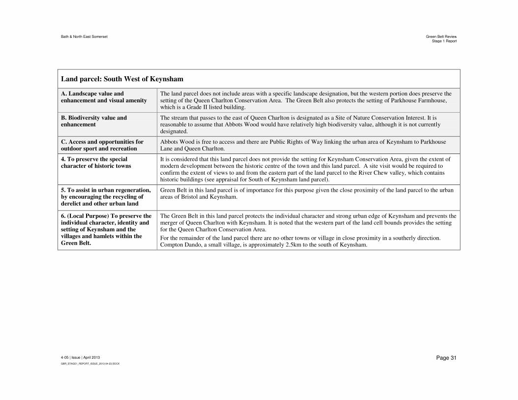
Bath & North East Somerset Green Belt ReviewStage 1 Report
4-05 | Issue | April 2013
GBR_STAGE1_REPORT_ISSUE_2013-04-23.DOCX
Page 31
Land parcel: South West of Keynsham
A. Landscape value and enhancement and visual amenity
The land parcel does not include areas with a specific landscape designation, but the western portion does preserve the setting of the Queen Charlton Conservation Area. The Green Belt also protects the setting of Parkhouse Farmhouse, which is a Grade II listed building.
B. Biodiversity value and enhancement
The stream that passes to the east of Queen Charlton is designated as a Site of Nature Conservation Interest. It is reasonable to assume that Abbots Wood would have relatively high biodiversity value, although it is not currently designated.
C. Access and opportunities for outdoor sport and recreation
Abbots Wood is free to access and there are Public Rights of Way linking the urban area of Keynsham to Parkhouse Lane and Queen Charlton.
4. To preserve the special character of historic towns
It is considered that this land parcel does not provide the setting for Keynsham Conservation Area, given the extent of modern development between the historic centre of the town and this land parcel. A site visit would be required to confirm the extent of views to and from the eastern part of the land parcel to the River Chew valley, which contains historic buildings (see appraisal for South of Keynsham land parcel).
5. To assist in urban regeneration, by encouraging the recycling of derelict and other urban land
Green Belt in this land parcel is of importance for this purpose given the close proximity of the land parcel to the urban areas of Bristol and Keynsham.
6. (Local Purpose) To preserve the individual character, identity and setting of Keynsham and the villages and hamlets within the Green Belt.
The Green Belt in this land parcel protects the individual character and strong urban edge of Keynsham and prevents the merger of Queen Charlton with Keynsham. It is noted that the western part of the land cell bounds provides the setting for the Queen Charlton Conservation Area.
For the remainder of the land parcel there are no other towns or village in close proximity in a southerly direction. Compton Dando, a small village, is approximately 2.5km to the south of Keynsham.

Bath & North East Somerset Green Belt ReviewStage 1 Report
4-05 | Issue | April 2013
GBR_STAGE1_REPORT_ISSUE_2013-04-23.DOCX
Page 32
Land parcel: South of Keynsham
Summary of Green Belt Purposes served
Located directly to the south of Keynsham, this land parcel comprises the River Chew valley and encompasses countryside around the small rural settlement of Chewton Keynsham.
The Green Belt designation within this land parcel serves the purposes of protecting the countryside from encroachment, preserving the setting of the historic town centre/Conservation Area of Keynsham, assisting urban regeneration and protecting the separate identities of Keynsham and Chewton Keynsham.
It is considered that the Green Belt directly south of Keynsham is not of importance for preventing the merger of Bristol and Keynsham and the Green Belt in this location does not prevent the sprawl of a large built-up area (i.e. Bristol or Bath).
The Green Belt has a notable role in protecting the River Chew Site of Nature Conservation Interest and preserving the setting of the Keynsham Conservation Area and bridge (Scheduled Ancient Monument). It also protects the rural setting of the Two Rivers Way Public Right of Way that follows the Chew River Valley.
1. Check the unrestricted sprawl of large built-up areas
The land parcel is contiguous to the built up area of Keynsham and the small rural settlement of Chewton Keynsham. Neither of these settlements are defined as “large built up areas” and therefore the Green Belt does not serve this purpose.
2. Prevent neighbouring towns merging into one another
The Green Belt directly south of Keynsham is not considered to be of importance for directly preventing the merger of Keynsham with Bristol or Bath.
3. Assist in safeguarding the countryside from encroachment
There is very little development within the land parcel other than a small pocket of existing rural development at Chewton Keynsham, which is characterised by its linear form on the Chewton Road and consists of residential and farm buildings. Therefore, the Green Belt in this land parcel strongly serves this purpose.
The land parcel’s topography is largely defined by the river valley that bisects the area running north to south. This has the effect of restricting views into and out of the land parcel, so reducing the feeling of encroachment from the nearby suburban development.
A. Landscape value and enhancement and visual amenity
The northern portion of the land parcel includes a Regionally Important Geological (RIC) site and provides the setting for the Keynsham Conservation Area.
There is a Scheduled Ancient Monument (Chewton Pack Horse Bridge crossing the River Chew – also Grade II listed) located in the central portion of the land parcel.
B. Biodiversity value and enhancement
The River Chew is a Site of Nature Conservation Interest. There are also two woodland areas within the land parcel that are designated as Sites of Nature Conservation Interest.

Bath & North East Somerset Green Belt ReviewStage 1 Report
4-05 | Issue | April 2013
GBR_STAGE1_REPORT_ISSUE_2013-04-23.DOCX
Page 33
Land parcel: South of Keynsham
C. Access and opportunities for outdoor sport and recreation
There are a number of Public Rights of Way that cross through the land parcel including the Two Rivers Way which follows the river valley. There are also byways and other public access routes which run through the land parcel.
4. To preserve the special character of historic towns
Green Belt in the northern portion of the land parcel fulfils the positive use of preserving the setting of the immediately adjacent Keynsham Conservation Area and a number of Grade II listed buildings that include the Albert Mill, Rockhill Farmhouse and Chew Cottages. It is noted that to the south the Green Belt has a further role in preserving the setting of a cluster of listed buildings and structures around the Chewton Place bridge.
5. To assist in urban regeneration, by encouraging the recycling of derelict and other urban land
Green Belt in this land parcel is of importance for this purpose given the close proximity of the land parcel to the urban area of Keynsham.
6. (Local Purpose) To preserve the individual character, identity and setting of Keynsham and the villages and hamlets within the Green Belt.
The Green Belt in this land parcel protects the individual character of Keynsham, in particular the southern part of the Keynsham Conservation Area, and prevents the merger of Chewton Keynsham with Keynsham.
For the remainder of the land parcel there are no other towns or village in close proximity in a southerly direction. Compton Dando, a small village, is approximately 2.5km to the south of Keynsham.

Bath & North East Somerset Green Belt ReviewStage 1 Report
4-05 | Issue | April 2013
GBR_STAGE1_REPORT_ISSUE_2013-04-23.DOCX
Page 34
Land parcel: South East of Keynsham
Summary of Green Belt Purposes served
This land parcel is situated to the south east of Keynsham and south west of Saltford.
Green Belt in the northern and eastern portion of this land parcel is of high importance on the basis that it lies directly in the Green Belt corridor between Bristol, Keynsham, Saltford and Bath (fundamental to the reasons behind the designation of Bristol and Bath Green Belt). It prevents the merger of Bath and Keynsham, while acknowledging that the area of land remaining open between Bath and Keynsham (and Bath and Saltford) is wider than that remaining open between Bristol and Keynsham.
The Green Belt designation within this land parcel also serves the purposes of protecting the countryside from encroachment, assisting urban regeneration and protecting the separate identities of Keynsham and Saltford under local purpose 6.
The Green Belt in this location does not prevent the sprawl of a large built-up area (Bristol or Bath) or help preserve the setting of the historic centre of Keynsham.
A notable positive use of the Green Belt in this land parcel is the protection of a Community Woodland that is designated as a Local Nature Reserve.
1. Check the unrestricted sprawl of large built-up areas
The land parcel is contiguous to the built up area of Keynsham and the village of Saltford. Neither of these settlements are defined as “large built-up areas” and therefore the Green Belt does not serve this purpose.
2. Prevent neighbouring towns merging into one another
The northern part of this land parcel falls within the Green Belt gap between Bristol, Keynsham and Bath. Measuring approximately 5.6km, the existing gap between Keynsham and Bath (at Whiteway Road) is wider than that between Bristol and Keynsham. The locations of Saltford and Corston between Keynsham and Bath means that maintaining the openness of all undeveloped land along the main transport corridor between settlements is important in retaining the integrity of this part of the Green Belt.
3. Assist in safeguarding the countryside from encroachment
The main use of land within the land parcel is agricultural and community woodland. There is also a business park that bounds the south east of the land parcel (see South of Saltford land parcel), which would not normally be appropriate development in the Green Belt. The majority of the Green Belt in the land parcel serves this purpose strongly and means that the single business park development referred to does not compromise the overall role of the Green Belt in this area.
The topography of the land is generally level and open meaning there would be limited potential to conceal development from view and prevent a sense of encroachment into the countryside.
B1. Landscape value and enhancement and visual amenity
There is no specific landscape designation within this land parcel, although the land parcel does provide the setting for the Grade II listed Keynsham Manor and Keynsham Manor (West).

Bath & North East Somerset Green Belt ReviewStage 1 Report
4-05 | Issue | April 2013
GBR_STAGE1_REPORT_ISSUE_2013-04-23.DOCX
Page 35
Land parcel: South East of Keynsham
B2. Biodiversity value and enhancement
The community woodland adjoining Keynsham is a designated as a Local Nature Reserve.
B3. Access and opportunities for outdoor sport and recreation
The portion of land to the East of Keynsham (in the north east corner of the land parcel) is Community Woodland.
The south west portion of the site is crossed by a Public Right of Way (PRoW) providing beneficial use of the countryside.
4. To preserve the special character of historic towns
It is considered that this land parcel does not provide the setting for Keynsham Conservation Area, given the extent of modern development between the historic centre of the town and this land parcel.
5. To assist in urban regeneration, by encouraging the recycling of derelict and other urban land
Green Belt in this land parcel is of importance for this purpose given the close proximity of the land parcel to the urban area of Keynsham.
6. (Local Purpose) To preserve the individual character, identity and setting of Keynsham and the villages and hamlets within the Green Belt.
The Green Belt in this land parcel protects the individual character of Keynsham and Saltford and prevents the merger of these two settlements. The remaining Green Belt gap between the Keynsham and Saltford is approximately 0.9km across the area crossed by Courtenay Rd/Manor Rd.
Comparison with SWRA Review (2006) Conclusions
SWRA Location Reference R – Keynsham/Saltford area. This study and the SWRA Review both conclude that the Green Belt in this area serves the purposes of preventing merger and safeguarding the countryside, but the SWRA Review also concludes that this area of land preserves the setting of an historic town. This may be due to the whole of Keynsham being given the status of a historic town in the SWRA Review, as opposed to only the historic centre in this study.

Bath & North East Somerset Green Belt ReviewStage 1 Report
4-05 | Issue | April 2013
GBR_STAGE1_REPORT_ISSUE_2013-04-23.DOCX
Page 36
Land parcel: North East of Keynsham
Summary of Green Belt Purposes served
This land parcel is situated between Keynsham and Saltford and contains the main transport corridor of the A4 and the Great Western railway line.
The Green Belt designation across the majority of the land parcel is of high importance on the basis that it lies directly in the Green Belt corridor between Bristol, Keynsham, Saltford and Bath (fundamental to the reasons behind the designation of Bristol and Bath Green Belt). It prevents the merger of Bristol, Bath and Keynsham, while acknowledging that the area of land remaining open between Bath and Keynsham is wider than that remaining open between Bristol and Keynsham.
It is considered that the Green Belt does play a role in constraining the potential urban sprawl of Bristol (Oldland and Willsbridge) in a southerly direction towards Keynsham, although sprawl may also be restricted by the River Avon. Green Belt within this land parcel also serves the purposes of protecting the countryside and assisting urban regeneration.
This land parcel is not considered to preserve the setting of the historic centre of Keynsham, due to the extent of intervening modern development.
Notable positive uses of the Green Belt in this land parcel include the Avon Country Park leisure uses and the protection of Community Woodland.
1. Check the unrestricted sprawl of large built-up areas
Major development within the land parcel would be within close proximity of the urban edge of Bristol at Oldland and Willsbridge. The Green Belt restricts sprawl of the built-up area of Bristol in a southerly direction, although the River Avon is also considered to restrict growth towards Keynsham.
The land parcel contains further strong boundary features, including the A4 and rail transport corridor that cross the parcel.
The land parcel is contiguous to the built up area of Keynsham and the village of Saltford. Neither of these settlements are defined as “large built-up areas” and therefore the Green Belt south of the railway line is not considered to serve this purpose.
2. Prevent neighbouring towns merging into one another
The entire land parcel falls within the Green Belt gap between Bristol, Keynsham and Bath. Measuring approximately 5km, the existing gap between Keynsham and Bath (Upper Weston) is wider than that between Keynsham and Bristol (the distance between the Ashmead Industrial Estate at Keynsham and properties at Willsbridge, Bristol to the north is approx. 1.7km).
The locations of Saltford and Corston between Keynsham and Bath means that retaining the openness of all undeveloped land along the main transport corridor between settlements is important in retaining the integrity of this part of the Green Belt.

Bath & North East Somerset Green Belt ReviewStage 1 Report
4-05 | Issue | April 2013
GBR_STAGE1_REPORT_ISSUE_2013-04-23.DOCX
Page 37
3. Assist in safeguarding the countryside from encroachment
South of the railway the majority of the land parcel remains in agricultural use and Manor Road Community Wood is located in the southern part of the land cell. To the north of the railway development includes a small industrial works that would not now normally comprise acceptable development in the Green Belt, and the Avon Valley Country Park. The majority of the Green Belt in the land parcel serves this purpose and means that the single industrial works development referred to does not compromise the overall role of the Green Belt in this area.
The land parcel contains relatively flat topography and therefore the Green Belt designation in this land parcel is important for preventing a sense of encroachment on the countryside from both Keynsham and Saltford.
A. Landscape value and enhancement and visual amenity
There is no specific landscape designation within this land parcel, although the Green Belt in this land parcel does help protect the partly rural settings for Keynsham Manor West (Grade II listed), located at the southern boundary of the land parcel, and Wick House Farmhouse (Grade II listed). Two bridges along the railway line and a milestone on the A4 are also Grade II listed.
B. Biodiversity value and enhancement
The community woodland adjoining Keynsham is designated as a Local Nature Reserve.
C. Access and opportunities for outdoor sport and recreation
The area of land south of the A4 is crossed by two main Public Rights of Way (PRoW) and contains the Manor Road Community Wood.
The area of land north of the A4 contains numerous PRoW as well as the Avon Valley Country Park, providing beneficial use of the countryside.
Only the portion of land in the northwest (west of the Adventure Park) does not allow for public access.
4. To preserve the special character of historic towns
It is considered that this land parcel does not provide the setting for Keynsham Conservation Area, given the extent of modern development between the historic centre of the town and this land parcel.
5. To assist in urban regeneration, by encouraging the recycling of derelict and other urban land
Green Belt in this land parcel is considered important for this purpose as it restricts the availability of greenfield sites to the east of Keynsham, resulting in development pressure on other urban land and therefore assisting in urban regeneration.
6. (Local Purpose) To preserve the individual character, identity and setting of Keynsham and the villages and hamlets within the Green Belt.
The Green Belt in this land parcel protects the individual character of Keynsham and Saltford and prevents the merger of these two settlements. The remaining Green Belt gap between the Keynsham and Saltford is approximately 0.95km along the A4.
Comparison with SWRA Review (2006) Conclusions
SWRA Location Reference R – Keynsham/Saltford area. This study and the SWRA Review both conclude that the Green Belt in this area serves the purposes of preventing merger and safeguarding the countryside, but the SWRA Review also concludes that this area of land preserves the setting of a historic town. This may be due to the whole of Keynsham being given the status of historic town in the SWRA Review, as opposed to only the historic centre in this study.

Bath & North East Somerset Green Belt ReviewStage 1 Report
4-05 | Issue | April 2013
GBR_STAGE1_REPORT_ISSUE_2013-04-23.DOCX
Page 38
6.3 Saltford and west of Bath
Land parcel: North of Saltford
Summary of Green Belt Purposes served
This land parcel is located to the north of Saltford and has a northern and eastern boundary formed largely by the River Avon.
Green Belt in this land parcel is located within the corridor of land between Bristol, Keynsham and Bath that is of high importance for preventing the merger of towns, although the Green Belt gap here is wider than that between Keynsham and Bristol.
The Green Belt designation within this land parcel also serves the purposes of protecting the countryside from encroachment, assisting urban regeneration, and preserving the identity and setting of Saltford under local purpose 6.
The Green Belt in this land parcel does not prevent the sprawl of a large built-up area or preserve the special character of a historic town.
Notable positive uses of the Green Belt in this land parcel include; preserving the setting of the Saltford Conservation Area and two Grade II* listed buildings; the protection of the Avon Farm SSSI; and safeguarding a rural section of the Bristol to Bath Cycle Path.
1. Check the unrestricted sprawl of large built-up areas
The land parcel is contiguous to the built up area of Saltford and relatively close to Keynsham (1.5km along the railway line) and the village of Bitton. None of these settlements are defined as “large built up areas” and therefore the Green Belt does not directly serve this purpose.
2. Prevent neighbouring towns merging into one another
Land in the western and southern portion of this land parcel falls directly within the Green Belt gap between Bristol, Keynsham and Bath. Measuring approximately 5km, the existing gap between Keynsham and Bath (Upper Weston) is wider than that between Bristol and Keynsham. The location of Saltford between Keynsham and Bath means that retaining the openness of all undeveloped land along the main transport corridor between settlements is important in retaining the integrity of this part of the Green Belt.
3. Assist in safeguarding the countryside from encroachment
The major land use in this land parcel is agricultural. A portion of land in the east of the land parcel is occupied by a Sewage Treatment Works (STW), which would now be regarded as inappropriate development for the Green Belt (based on NPPF policy). The majority of the Green Belt in this land parcel serves this purpose strongly and means that the STW, which is well landscaped, does not compromise the overall role of the Green Belt in this area.
The topography of the land is level and generally open in nature and therefore the Green Belt designation in this land parcel is of importance for preventing a sense of encroachment on the countryside from both Keynsham and Saltford.
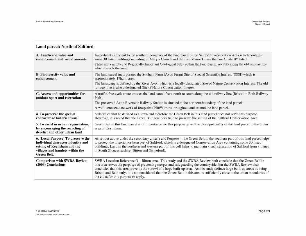
Bath & North East Somerset Green Belt ReviewStage 1 Report
4-05 | Issue | April 2013
GBR_STAGE1_REPORT_ISSUE_2013-04-23.DOCX
Page 39
Land parcel: North of Saltford
A. Landscape value and enhancement and visual amenity
Immediately adjacent to the southern boundary of the land parcel is the Saltford Conservation Area which contains some 30 listed buildings including St Mary’s Church and Saltford Manor House that are Grade II* listed.
There are a number of Regionally Important Geological Sites within the land parcel, notably along the old railway line which bisects the area.
B. Biodiversity value and enhancement
The land parcel incorporates the Stidham Farm (Avon Farm) Site of Special Scientific Interest (SSSI) which is approximately 17ha in area.
The landscape is defined by the River Avon which is a locally designated Site of Nature Conservation Interest. The old railway line is also a designated Site of Nature Conservation Interest.
C. Access and opportunities for outdoor sport and recreation
A traffic-free cycle route crosses the land parcel from north to south along the old railway line (Bristol to Bath Railway Path).
The preserved Avon Riverside Railway Station is situated at the northern boundary of the land parcel.
A well-connected network of footpaths (PRoW) runs throughout and around the land parcel.
4. To preserve the special character of historic towns
Saltford cannot be defined as a town and therefore the Green Belt in this land parcel does not serve this purpose. However, it is noted that the Green Belt here does help to preserve the setting of the Saltford Conservation Area.
5. To assist in urban regeneration, by encouraging the recycling of derelict and other urban land
Green Belt in this land parcel is of importance for this purpose given the close proximity of the land parcel to the urban area of Keynsham.
6. (Local Purpose) To preserve the individual character, identity and setting of Keynsham and the villages and hamlets within the Green Belt.
As set out above under the secondary criteria and Purpose 4, the Green Belt in the southern part of this land parcel helps to protect the historic northern part of Saltford, which is a designated Conservation Area containing some 30 listed buildings. Land in the northern and western part of this cell helps to maintain visual separation of Saltford from villages in South Gloucestershire (Bitton and Swineford).
Comparison with SWRA Review (2006) Conclusions
SWRA Location Reference O – Bitton area. This study and the SWRA Review both conclude that the Green Belt in this area serves the purposes of preventing merger and safeguarding the countryside, but the SWRA Review also concludes that this area prevents the sprawl of a large built-up area. As this study defines large built-up areas as being Bristol and Bath only, it is not considered that the Green Belt in this area is sufficiently close to the urban boundaries of the cities for this purpose to apply.

Bath & North East Somerset Green Belt ReviewStage 1 Report
4-05 | Issue | April 2013
GBR_STAGE1_REPORT_ISSUE_2013-04-23.DOCX
Page 40
Land parcel: South of Saltford
Summary of Green Belt Purposes served
This land parcel is located to the south of Saltford with an eastern boundary clearly defined by the River Avon and the A4.
Green Belt in this land parcel is located within the corridor of land between Keynsham and Bath that is of high importance for preventing the merger of towns, although the Green Belt gap here is wider than that between Keynsham and Bristol. Green Belt at the eastern boundary of the land parcel helps to prevent ribbon development along the A4 towards Bath.
The Green Belt designation within this land parcel also serves the purposes of protecting the countryside from encroachment, assisting urban regeneration, and preserving the identity and setting of Saltford and Corston under Purpose 6 (local). Green Belt in parts of this land parcel in close proximity to Bath may have a role in terms of the World Heritage Site setting.
The Green Belt in this land parcel does not prevent the sprawl of a large built up area.
Positive uses of the Green Belt in this land parcel include the protection of the Folly Wood Site of Nature Conservation Interest and Saltford golf course.
1. Check the unrestricted sprawl of large built-up areas
The land parcel is contiguous to the built up area of Saltford and Corston and the western portion of the land parcel is relatively close to Keynsham. None of these settlements are defined as “large built up areas” and therefore the Green Belt does not serve this purpose.
2. Prevent neighbouring towns merging into one another
All of this land parcel falls within the Green Belt gap between Bristol, Keynsham and Bath. Measuring approximately 5.6km, the existing gap between Keynsham and Bath (at Whiteway Road) is wider than that between Bristol and Keynsham. The locations of Saltford and Corston between Keynsham and Bath means that retaining the openness of all undeveloped land along the main transport corridor between settlements is important in retaining the integrity of this part of the Green Belt.
Green Belt along the A4 helps to prevent ribbon development between Keynsham and Bath.
3. Assist in safeguarding the countryside from encroachment
The main land use within the land parcel is agricultural. Folly Wood/Saltford Golf course occupies the central portion of the land parcel. A suburban area of Saltford is incorporated within land parcel (but outside the Green Belt) as well as a business park located in the south western corner which is washed over by the Green Belt designation. The business park would not now be considered appropriate development within the Green Belt (assuming re-use of brownfield land existing buildings does not apply). Nevertheless, the majority of the Green Belt in the land parcel serves this purpose strongly and means that the single business park development referred to does not compromise the overall role of the Green Belt in this area.

Bath & North East Somerset Green Belt ReviewStage 1 Report
4-05 | Issue | April 2013
GBR_STAGE1_REPORT_ISSUE_2013-04-23.DOCX
Page 41
Land parcel: South of Saltford
Land rises gradually to the south of Saltford and as a result there is limited potential to conceal development from view and reduce a sense of encroachment of development into the countryside. The gradients are more pronounced in the north east of the land parcel and there is notable stream valley in the area of Folly Wood and the Saltford Golf Course.
A.Landscape value and enhancement and visual amenity
It is considered that the land parcel provides the setting for Grade II listed buildings in the immediate area south east of Saltford, namely the Turnpike, 565 Bath Road and Highnams Farm Bridge. The land parcel also provides the setting for the Grade II listed building, Keynsham Manor, which is situated on the north western boundary of the land parcel.
B. Biodiversity value and enhancement Folly Wood is a designated Site of Nature Conservation Interest.
C. Access and opportunities for outdoor sport and recreation
The land parcel is dissected by a National/Local Cycle Route and the Folly Wood/Saltford Golf Course provides access to the countryside.
There are two Public Rights of Way that cut across both the south west and south east corners of the site as well as the River Avon Trail located on the eastern boundary of the land parcel.
4. To preserve the special character of historic towns
Saltford is not defined as a town for appraising this purpose and therefore the Green Belt in this land parcel does not serve this purpose. However, it is noted that the Green Belt here does help to preserve the setting of the Saltford Conservation Area.
The Green Belt in parts of this land parcel in close proximity to Bath may have a role in terms of the World Heritage Site setting.
5. To assist in urban regeneration, by encouraging the recycling of derelict and other urban land
Green Belt in this land parcel is of importance for this purpose given the close proximity of the land parcel to the urban area of Keynsham.
6. (Local Purpose) To preserve the individual character, identity and setting of Keynsham and the villages and hamlets within the Green Belt.
The Green Belt in this land parcel helps to preserve the identity and setting of the villages of Saltford and Corston.

Bath & North East Somerset Green Belt ReviewStage 1 Report
4-05 | Issue | April 2013
GBR_STAGE1_REPORT_ISSUE_2013-04-23.DOCX
Page 42
Land parcel: North West of Bath
Located to the north west of Bath this land parcel encompasses the urban areas of Weston and Upper Weston, which are excluded from the Green Belt designation, and the rural settlements of Kelston and North Stoke that are washed over by the Green Belt. The south eastern part of the land cell bounds the urban area of Lansdown.
The Green Belt designation in this land parcel is of high importance for preventing the sprawl of Bath into open countryside that could in time threaten coalescence of the rural settlements of Kelston and North Stoke. The Green Belt in this land parcel if also of high importance on the basis that it contributes towards preventing the merger of Bristol, Keynsham and Bath, while it is acknowledged that the area of land remaining open between Bath and Keynsham (along the A4) and Bath and Bristol (along the A431) is wider than that between Keynsham and Bristol.
Within this land parcel the Green Belt designation also serves the purposes of protecting the countryside from encroachment, assisting urban regeneration and preserving the setting of the Bath World Heritage Site. The Green Belt also preserves the identity and settings of Kelston and North Stoke under local Purpose 6.
Further notable positive planning uses of Green Belt land in this area include preserving the setting of the Kelston, North Stoke and Bath Conservation Areas; recreational uses, such as playing fields, Public Rights of Way and the Bristol to Bath Cycle Way; and the protection of Sites of Nature Conservation Importance.
1. Check the unrestricted sprawl of large built-up areas
This land parcel covers a large rural area, however there are portions of land that encapsulate areas of the City of Bath at Weston and Upper Weston or are contiguous to the City of Bath. The Green Belt in the south eastern portion of the land parcel is therefore of particular importance for preventing urban sprawl. It is considered that Kelston is located sufficiently far from the urban boundary of Bath (approx. 2.3km along the route of the A431) that it is not currently threatened with merger as a result of sprawl, unless major development took a linear form along the A431.
The A431 bisects the western portion of the land parcel running in a north westerly direction, while Lansdown Lane follows a northerly route from Upper Weston. The River Avon forms a clear boundary along the western boundary and there are a number of woodland areas that define portions of the site, however there is no consistent barrier that would restrict development sprawl in to the Green Belt.
The urban outlines of Weston, Upper Weston and Lansdown are irregular. Existing development at Weston and Upper Weston appears to be have been shaped by the topography of the valley within which it is located. In contrast, Lansdown ascends the ridgeline above Bath. The potential for consolidation of the urban form between these two areas of Bath is influenced by the Green Belt designation and potentially the topography of Weston and Primrose Hills.
2. Prevent neighbouring towns merging into one another
The land parcel falls directly within the Green Belt gap between Bristol, Keynsham and Bath. Measuring approximately 5km, the existing gap between Keynsham and Bath (Upper Weston) is wider than that between Bristol and Keynsham. The location of Saltford between Keynsham and Bath means that retaining the openness of

Bath & North East Somerset Green Belt ReviewStage 1 Report
4-05 | Issue | April 2013
GBR_STAGE1_REPORT_ISSUE_2013-04-23.DOCX
Page 43
Land parcel: North West of Bath
all undeveloped land along the main A4 transport corridor between settlements is important in retaining the integrity of this part of the Green Belt.
Further to the north, the Green Belt in this land parcel helps to prevent ribbon development and progression towards merger of towns along the A431, where the existing gap between Upper Weston, Bath and Oldland, Bristol is approx. 5.5km. The existing settlements within this Green Belt gap of Kelston and Bitton are very small when compared to Keynsham and Saltford, so the land here remains more open.
3. Assist in safeguarding the countryside from encroachment
The main use of land within this land parcel is for farmland and there is also some woodland (Weston Wood) and recreational land use i.e. Kelston Park, playing fields and Public Rights of Way. The land parcel includes the small villages of North Stoke and Kelston, however there is limited significant development with the exception of Weston and Upper Weston, which are excluded from the Green Belt. Therefore, the Green Belt strongly serves this purpose.
The topography of the portion of the land parcel surrounding Upper Weston/Weston (Bath) is characterised by a number of relatively prominent hills and slopes to the northeast of the River Avon, including Penn Hill and Kelston Round Hill. This topography is important in providing aesthetic views to and from the countryside and means that the Green Belt helps to prevent encroachment on the countryside that would be highly visible from Saltford, Corston and parts of Bath.
A. Landscape value and enhancement and visual amenity
The entire land parcel is designated as part of the Cotswold Area of Outstanding Natural Beauty (AONB) and the land parcel adjoins and incorporates part of the Bath World Heritage Site and Conservation Area. The rural settlements of Kelston and North Stoke are both designated as Conservation Areas.
The land parcel contains within it a number of Ancient and Semi Natural Woodland areas.
B. Biodiversity value and enhancement
There are numerous sites of Nature Conservation Interest, including the River Avon that flows along the western boundary of the land parcel.
C. Access and opportunities for outdoor sport and recreation
There are several sites used as playing fields, and there is a network of public footpaths across the land parcel (Public Rights of Way) which include the River Avon Trail and the Cotswold Way. The Traffic Free Cycle route along the Bristol and Bath Railway Path passes along the southwestern boundary of the land parcel.
In the northern portion of the site there is a Byway located around North Stoke.
4. To preserve the special character of historic towns
The Green Belt in this land parcel serves this purpose strongly as it contains part of and provides the setting for the Bath World Heritage Site.
5. To assist in urban regeneration, by encouraging the recycling of derelict and other urban land
Green Belt in this land parcel is of importance for this purpose given the close proximity of the land parcel to the urban area of Bath.

Bath & North East Somerset Green Belt ReviewStage 1 Report
4-05 | Issue | April 2013
GBR_STAGE1_REPORT_ISSUE_2013-04-23.DOCX
Page 44
Land parcel: North West of Bath
6. (Local Purpose) To preserve the individual character, identity and setting of Keynsham and the villages and hamlets within the Green Belt.
The Green Belt in this land parcel helps to maintain the separate identity and character of the villages of Kelston and North Stoke. The distance between these settlements and large settlements and location north of the River Avon means they are less liable to merger than other rural settlements in Bath & North East Somerset.

Bath & North East Somerset Green Belt ReviewStage 1 Report
4-05 | Issue | April 2013
GBR_STAGE1_REPORT_ISSUE_2013-04-23.DOCX
Page 45
Land parcel: South West of Bath
Summary of Green Belt purposes served
This land parcel flanks the south western urban boundary of Bath and encompasses countryside around the rural settlements of Newton St Loe and Englishcombe.
The Green Belt designation in this land parcel is of high importance for preventing the sprawl of Bath into open countryside that could result in the coalescence of the city with the villages of Newton St Loe and Englishcombe. Green Belt in the northern portion of this land parcel is of particularly high importance on the basis that it contributes directly to preventing the merger of Bath and Keynsham, while acknowledging that the area of land remaining open between Bath and Keynsham (and Bath and Saltford) is wider than that remaining open between Bristol and Keynsham.
The Green Belt designation within this land parcel also serves the purposes of protecting the countryside from encroachment, assisting urban regeneration and preserving the special character of the Bath World Heritage Site. Within the southern portion of the land parcel the Green Belt helps to prevent development on the A367 corridor that could contribute toward the merger of Bath and Radstock.
Notable positive uses of the Green Belt in this land parcel include preserving the setting of the Englishcombe Conservation Area; the protection of a Site of Special Scientific Interest and a Local Nature Reserve; and leisure uses that include the River Avon Trail and Bristol and Bath Railway Path.
1. Check the unrestricted sprawl of large built-up areas
Major development would be contiguous to the boundary of Bath or within close proximity of the city. The northern boundary of the land parcel is clearly defined by the River Avon and the northern portion of the land parcel contains the A4 Bristol Road and Pennyquick, a minor road that creates a triangular portion of land east of Newton St Loe.
There is limited existing development within the land parcel with the exception of the settlements of Newton St Loe and Englishcombe. The Green Belt therefore helps to prevent sprawl into open land and the coalescence of these rural settlements with the city. Whiteway Road generally provides a clear urban edge to Bath and therefore there are no significant opportunities for consolidation of the urban form that the Green Belt would otherwise prevent.
2. Prevent neighbouring towns merging into one another
Land in the northern portion of this land cell falls within the important Green Belt gap between Bristol, Keynsham and Bath. Measuring approximately 4.2km, the existing gap between Bath and Keynsham across the northern portion of this land parcel is wider than that between Bristol and Keysnham. However, the location of Saltford between Bath and Keynsham means that retaining the openness of all undeveloped land along the A4 corridor between settlements is important in retaining the integrity of this part of the Green Belt.
The Green Belt designation in the southern portion of the land parcel adjoining the A367 is also of importance for preventing the merger of towns, while acknowledging that there is a greater distance again between Bath and Radstock (approximately 7.5km). Green Belt in the central part of the land parcel does not prevent merger of

Bath & North East Somerset Green Belt ReviewStage 1 Report
4-05 | Issue | April 2013
GBR_STAGE1_REPORT_ISSUE_2013-04-23.DOCX
Page 46
Land parcel: South West of Bath
towns.
3. Assist in safeguarding the countryside from encroachment
The main land use within the land parcel is agricultural, with associated farm buildings. There are also a number of woodland areas scattered across the land parcel. As there is very limited existing development in the land parcel, the Green Belt strongly serves this purpose and development would result in a detrimental form of encroachment into the countryside.
The undulating topography of the land includes a series of valleys formed by the Newton Brook and tributaries (up to around 100m in relief), which obscures views into and across the land parcel, including the visibility and sense of encroachment of the urban boundary of Bath from the west.
B1. Landscape value and enhancement and visual amenity
Englishcombe is designated as a Conservation Area and therefore the Green Belt in this location helps to preserve the setting of this historic settlement. There are also three Scheduled Ancient Monuments within the land parcel, two of which are located within the Englishcombe Conservation Area.
B2. Biodiversity value and enhancement There is a SSSI and a Site of Nature Conservation Interest adjacent to the railway line and the A4. The land parcel contains numerous other Sites of Nature Conservation Interest and there is a large Local Nature Reserve Area (LNR) in the north eastern portion of the land parcel immediately adjacent to Twerton. The LNR encapsulates a Regionally Important Geological Site.
B3. Access and opportunities for outdoor sport and recreation
There are several recreation ground areas within the land parcel, as well as Public Rights of Way including: the River Avon Trail and the Bristol and Bath Railway Path.
4. To preserve the special character of historic towns
The land parcel is immediately adjacent to Bath and is part of and therefore of importance in protecting the setting of the World Heritage Site.
5. To assist in urban regeneration, by encouraging the recycling of derelict and other urban land
The Green Belt in this land parcel serves this purpose strongly as it contains part of and provides the setting for the Bath World Heritage Site.
6. (Local Purpose) To preserve the individual character, identity and setting of Keynsham and the villages and hamlets within the Green Belt.
As set out above under purpose 1, the Green Belt in this land parcel protects the individual character, identity and setting of the villages of Newton St Loe and Englishcombe.
Comparison with SWRA Review (2006) Conclusions
SWRA Location Reference T – Newton St Loe area. This study and the SWRA Review both conclude that the Green Belt in this area serves the purposes of preventing sprawl, preventing merger, safeguarding the countryside, and preserving the setting of a historic town.

Bath & North East Somerset Green Belt ReviewStage 1 Report
4-05 | Issue | April 2013
GBR_STAGE1_REPORT_ISSUE_2013-04-23.DOCX
Page 47
6.4 Around Bath
Land parcel: South of Bath
This land parcel is situated to the south of Bath, encompasses countryside around the rural settlements of South Stoke and Combe Hay, and has a southern boundary defined by the valley of the Cam Brook.
The Green Belt designation in this land parcel is of high importance for preventing the sprawl of Bath into open countryside that could also result in the coalescence of the city with the villages of South Stoke and Combe Hay.
Green Belt in this land parcel serves the purpose of preventing the merger of Bath and Radstock (and the intervening village of Peasedown St John), although the area of land remaining open between Bath and Radstock is greater than that within the Bristol, Keynsham and Bath corridor.
The Green Belt designation within this land parcel also serves the purposes of protecting the countryside from encroachment, assisting urban regeneration and preserving the special character of the Bath World Heritage Site. Under local purpose 6, the Green Belt helps to preserve the identity and settings of South Stoke and Combe Hay.
Notable positive uses of the Green Belt in this land parcel include preserving the setting of the South Stoke and Combe Hay Conservation Areas; and the protection of Sites of Nature Conservation Interest and a good network of Public Rights of Way.
1. Check the unrestricted sprawl of large built-up areas
Major development within the land parcel would be contiguous to the urban boundary of Bath or within close proximity to the urban edge of Bath and therefore the Green Belt is of particular importance for preventing urban sprawl.
The southern boundary of the land parcel is formed by a minor road that broadly follows the course of Cam Brook, providing a clear natural boundary. South Stoke Lane/Hodshill is a minor road following a north/south route and is not therefore well orientated to act as a limit to development.
There is limited existing development within this land parcel with the exception of the settlements of South Stoke and Combe Hay. The Green Belt helps to prevent sprawl into open land and the coalescence of these rural settlements with the city. In particular, the Green Belt gap between Bath and South Stoke is very narrow, to the extent that even relatively limited developments could threaten coalescence with the large built up area.
2. Prevent neighbouring towns merging into one another
The urban edge of Radstock is approximately 7.5km from the south western edge of Bath along the route of the A367, while the location of Peasedown St John between the town and city is of significance when appraising the potential for merger (Peasedown St John is located approximately 4.5km south west of the southern western edge of Bath). The greater distances between settlements along the A367 means that major development or

Bath & North East Somerset Green Belt ReviewStage 1 Report
4-05 | Issue | April 2013
GBR_STAGE1_REPORT_ISSUE_2013-04-23.DOCX
Page 48
Land parcel: South of Bath
consolidation of the urban form in this land parcel could be accommodated without significantly decreasing the distance between settlements, when compared to locations in the Bristol to Bath corridor.
3. Assist in safeguarding the countryside from encroachment
The majority of the land within this land parcel is used for agricultural purposes; the cell is also largely covered by woodland areas namely: Warren Wood, Engine Wood, Rowley Wood, Grove Wood, and Week Wood. The village of South Stoke and the Park & Ride site off the A367 are washed over by the Green Belt designation. Local transport infrastructure can be appropriate in Green Belt areas (NPPF para. 90) and therefore does not compromise the importance of the Green Belt in this land parcel, which strongly serves this purpose.
The land north of South Stoke (& immediately south of Bath) is generally level, so views of major development from land at a similar elevation would not be restricted, resulting in a sense of encroachment into the countryside. The topography changes in the southern portion of the land parcel, with land dropping into the valley formed by Cam Brook. Development in this location, on the south-facing hillside, is expected to be visible from a larger number of vantage points, resulting in even greater encroachment into the countryside.
A. Landscape value and enhancement and visual amenity
The land parcel is designated as part of the Cotswolds Area of Outstanding Natural Beauty (AONB) and contains the South Stoke and Combe Hay Conservation Areas.
B. Biodiversity value and enhancement
The land parcel contains a number of Sites of Nature Conservation Interest.
C. Access and opportunities for outdoor sport and recreation
There is a relatively dense network of Public Rights of Way throughout the site and a Byway in the western portion of the land parcel.
4. To preserve the special character of historic towns
The Green Belt in this land parcel serves this purpose strongly as it contains part of and provides the setting for the Bath World Heritage Site.
5. To assist in urban regeneration, by encouraging the recycling of derelict and other urban land
Green Belt in this land parcel is of importance for this purpose given the close proximity of the land parcel to the urban area of Bath.
6. (Local Purpose) To preserve the individual character, identity and setting of Keynsham and the villages and hamlets within the Green Belt.
The Green Belt in this land parcel protects the individual character, identity and setting of South Stoke and Combe Hay. The remaining Green Belt gap between Bath and South Stoke is particularly narrow.
Comparison with SWRA Review (2006) Conclusions
SWRA Location Reference U – Odd Down area. This study and the SWRA Review both conclude that the Green Belt in this area serves the purposes of preventing sprawl, preventing merger, safeguarding the countryside, and preserving the setting of a historic town.

Bath & North East Somerset Green Belt ReviewStage 1 Report
4-05 | Issue | April 2013
GBR_STAGE1_REPORT_ISSUE_2013-04-23.DOCX
Page 49
Land parcel: South East of Bath
This land parcel largely occupies a plateau to the south east of Bath, but also extends to include Bathford located on the east side of the River Avon. It contains a range of land uses including: the university campus; the villages of Bathford, Larch Wood and Combe Down that are excluded from the Green Belt designation; and the settlements of Monkton Combe and Claverton that are washed over by the Green Belt.
The Green Belt designation in this land parcel is of high importance for preventing the sprawl of Bath into open countryside and that could result in the coalescence of the city with the villages of Monkton Combe, Claverton and Bathford.
Green Belt in this land parcel is of importance for preventing the merger of Bath with Bradford-upon Avon (and the intervening village of Winsley), while acknowledging that the levels of existing development and pressures for development are less than within Bristol, Kenysham and Bath corridor.
The Green Belt designation within this land parcel also serves the purposes of protecting the countryside from encroachment, assisting urban regeneration and preserving the special character of the Bath World Heritage Site. Under local purpose 6, the Green Belt helps to preserve the identity and settings of the rural settlements of Monkton Combe, Larch Wood, Claverton and Bathford.
Notable positive planning uses of the Green Belt in this land parcel include preserving the setting of the Monkton Combe, Claverton and Bathford Conservation Areas; leisure uses such as the Bath Golf Club, playing fields and parks; and the protection of international, national and local biodiversity designations.
1. Check the unrestricted sprawl of large built-up areas
Major development within the land parcel would be contiguous to the urban boundary of Bath or within close proximity of the urban edge of Bath and therefore the Green Belt is of importance for preventing urban sprawl.
The land parcel is traversed by a number of strong boundary features in a north south direction, including the A36, the railway, the River Avon, the Kennet & Avon Canal and dense woodland to the east. The A4 and railway line provide a clear boundary to the north of Bathampton, while in the southern portion of the land cell, the steep hill descending to the Midford Brook provides a potential natural limit to development.
Bath University, Larch Wood, and the adjoining commercial development are excluded from the Green Belt designation while other developed areas are washed over. The south eastern fringe of Bath is relatively fragmented and the topography, inconsistency of urban edge and diversity of development types may present opportunities for the consolidation (“rounding off”) the urban edge of Bath, while retaining areas of open space.
2. Prevent neighbouring towns merging into one another
To the south east of Bath the nearest towns of Bradford-upon-Avon and Trowbridge (in Wiltshire) are located approximately 5.4km and 8.3km from the urban edge of Bath respectively (measured from Combe Down, Bath to the western edges of the towns). The village of Winsley lies on the route between Bath and Bradford-upon-Avon along the B3108. The distance between Bath and Bradford-upon-Avon is similar to that between Upper Weston, Bath and Oldland, Bristol.
The Green Belt designation status of the land parcel has helped to prevent ribbon development out of the City of

Bath & North East Somerset Green Belt ReviewStage 1 Report
4-05 | Issue | April 2013
GBR_STAGE1_REPORT_ISSUE_2013-04-23.DOCX
Page 50
Land parcel: South East of Bath
Bath along transport corridors such as the A36 and A363.
3. Assist in safeguarding the countryside from encroachment
This land parcel contains a wide variety of development types. These include agricultural land and large areas of woodland; namely: Priory Wood, Beech Wood, Fairy Wood, Claverton Wood, Hengrove Wood etc.
There is significant existing development in this land parcel, including the University of Bath and settlements excluded from the Green Belt, namely Combe Down, Bathford and Larch Wood. There are also other areas of development that are washed over the by the Green Belt, such as at Perrymead, a water treatment works off the Ave, and a school and clinic on Claverton Down Road. Leisure uses include the University sports pitches and athletics track and Bath Golf Club.
Compared to other land parcels appraised, there are slightly more incidents of development that would not normally be appropriate in the Green Belt (assuming re-use of brownfield sites does not apply). This, together with exclusions from the Green Belt at the University and Larch Wood lend the route around Claverton Down Road a part rural, part peri-urban character. Nevertheless, the majority of the land parcel is made up of agricultural land, woodland and outdoor leisure uses appropriate in the Green Belt, and therefore the Green Belt does serve the purpose of protecting the countryside.
The topography of the land parcel is broadly formed of a plateau, with slopes descending to Bath and Bathampton on the western and northern sides and relatively steep inclines down to the Avon, Avon Canal and Midford Brook on the eastern and southern sides. Development on the top of the plateau is not expected to be generally visible from the valleys in which Bath, Bathford, Claverton and Monkton Combe are located.
A. Landscape value and enhancement and visual amenity
The land parcel is designated as an AONB, contains several Scheduled Ancient Monument sites and there are also four Parks & Gardens of National Historic Importance. The cell encapsulates areas of the Bath World Heritage site and the Conservation Areas of Monkton Combe, Claverton & Bathford. There are also numerous Regionally Important Geological Sites scattered across the parcel of land.
B. Biodiversity value and enhancement
The land parcel contains the Combe Downe & Bathampton Down Mines SSSI and part of the Bath & Bradford on Avon Bats Special Area of Conservation (SAC).
The land parcel contains numerous woodland and forestry features which have been designated as Sites of Nature Conservation Interest.
C. Access and opportunities for outdoor sport and recreation
Playing fields and parks and gardens cover large areas within different portions of the land parcel. The Bath Golf Club is located in the north west portion of the land parcel (north of Claverton Down).
An extensive network of Public Rights of Ways, cycle routes and other permitted access routes run throughout the land parcel, including the Cotswold Way.
4. To preserve the special character of historic towns
The Green Belt in this land parcel serves this purpose strongly as it contains part of and provides the setting for the Bath World Heritage Site.

Bath & North East Somerset Green Belt ReviewStage 1 Report
4-05 | Issue | April 2013
GBR_STAGE1_REPORT_ISSUE_2013-04-23.DOCX
Page 51
Land parcel: South East of Bath
5. To assist in urban regeneration, by encouraging the recycling of derelict and other urban land
Green Belt in this land parcel is of importance for this purpose given the close proximity of the land parcel to the urban area of Bath.
6. (Local Purpose) To preserve the individual character, identity and setting of Keynsham and the villages and hamlets within the Green Belt.
The Green Belt in this land parcel protects the individual character, identity and setting of the rural settlements of Monkton Combe, Larch Wood, Claverton and Bathford.
Comparison with SWRA Review (2006) Conclusions
SWRA Location Reference W – East of Bath area. This study and the SWRA Review both conclude that the Green Belt in this area serves the purposes of preventing sprawl, preventing merger, safeguarding the countryside, and preserving the setting of a historic town.

Bath & North East Somerset Green Belt ReviewStage 1 Report
4-05 | Issue | April 2013
GBR_STAGE1_REPORT_ISSUE_2013-04-23.DOCX
Page 52
Land parcel: North East of Bath
Located to the north east of Bath, this land parcel encompasses the villages of Batheaston and Northend, which are excluded from the Green Belt.
The Green Belt designation is of high importance for preventing the sprawl of Bath into open countryside that would also result in the coalescence of the city with the rural settlements of Batheaston and Northend.
The Green Belt designation within this land parcel also serves the purpose of protecting the countryside from encroachment, assisting urban regeneration and preserving the special character of the Bath World Heritage Site.
With respect to the purpose of preventing the merger of towns, the Green Belt is not of importance in this land parcel given that the nearest town of Corsham, Wiltshire, is almost 10km to the east.
Notable positive uses of the Green Belt in this location including preserving the setting of the Batheaston Conservation Area and fort on Little Solsbury Hill (Scheduled Ancient Monument); protection of international, national and local biodiversity sites; and leisure uses that include the Limestone Link Public Right of Way.
1. Check the unrestricted sprawl of large built-up areas
The land parcel is contiguous to the built up area of Bath at Lambridge, Lower Swainswick and Bailbrook, as well as the rural settlement of Batheaston/Northend. Batheaston/Northend is separated from the large built-up area of Bath by Green Belt designation along the River Avon. The Green Belt therefore serves the purpose of preventing the sprawl of a large built-up area in the south western portion of the land cell and helps to prevent the coalescence of the village of Batheaston with Bath.
The A46 defines the western boundary of the land parcel, while the A4 and By Brook define the southern boundary. St Catherine’s Brook and its tributaries and a series of minor roads spread out in a radial pattern across the land parcel from Batheaston.
There is very limited existing development within the land parcel with the exception of Batheaston/Northend village and therefore the Green Belt designation does not prevent opportunities for consolidation of Bath’s urban form.
2. Prevent neighbouring towns merging into one another
The town of Corsham in Wiltshire is located approximately 9.75km to the east of Bath (Lower Swainswick) along the A4 corridor. Given the large distance involved, the Green Belt is of lesser importance for preventing the merger of towns than elsewhere in between Bristol and Bath.
In a northerly direction, the closest substantial settlement is the village of Marshfield (approximately 6.1km from the edge of Batheaston); while to the northeast the nearest village is Colerne (approximately 4.3km from the edge of Batheaston). These settlements are not defined as “towns” for appraising this purpose.

Bath & North East Somerset Green Belt ReviewStage 1 Report
4-05 | Issue | April 2013
GBR_STAGE1_REPORT_ISSUE_2013-04-23.DOCX
Page 53
Land parcel: North East of Bath
3. Assist in safeguarding the countryside from encroachment
The major land use within this land parcel is agriculture and there are also significant woodland areas including Cowlease Wood, Hunterwick Wood, and Bailey’s Wood etc. There is very limited development in the land cell and a disused airfield located just off the A46 now also appears to be used for agriculture and forestry. The Green Belt in this land parcel therefore strongly serves this purpose.
The topography of the land parcel varies between the level plateau in the north, occupied by the former airfield, and the undulating land in the southern portion close to Batheaston, which is characterised by small valleys formed by St Catherine’s Brook and its tributaries. Hills such as Little Solsbury Hill and The Mount would restrict views into and out from the land parcel, potentially helping to screen and reduce a sense of encroachment into the countryside depending on the location of development.
Landscape value and enhancement and visual amenity
Much of the land cell is designated as part of the Cotswold Area of Outstanding Natural Beauty and the southern portion provides the setting for the Batheaston Village Conservation Area.
The south west portion of the land parcel contains a Scheduled Ancient Monument, the fort on Little Solsbury Hill.
Biodiversity value and enhancement The land Parcel contains the Combe Downe & Bathampton Down Mines SSSI and part of the Bath & Bradford on Avon Bats Special Area of Conservation (SAC).
The parcel is largely characterised by the numerous woodland and forestry features, many of which have been designated as Sites of Nature Conservation Interest.
Access and opportunities for outdoor sport and recreation
An extensive network of Public Rights of Way, including the Limestone Link route, a Byway and short bridleway east of Upper Swainswick, are interconnected throughout the land parcel.
4. To preserve the special character of historic towns
The Green Belt in this land parcel serves this purpose strongly as it is directly adjacent to and provides the setting for the Bath World Heritage Site.
5. To assist in urban regeneration, by encouraging the recycling of derelict and other urban land
Green Belt in this land parcel is of importance for this purpose given the close proximity of the land parcel to the urban area of Bath.
6. (Local Purpose) To preserve the individual character, identity and setting of Keynsham and the villages and hamlets within the Green Belt.
The Green Belt in this land parcel helps to maintain the separate identity and character of the rural settlement of Batheaston/Northend.

Bath & North East Somerset Green Belt ReviewStage 1 Report
4-05 | Issue | April 2013
GBR_STAGE1_REPORT_ISSUE_2013-04-23.DOCX
Page 54
Land parcel: North of Bath
Located north of the Fairfield Park and Lansdown areas of Bath, this land parcel incorporates the small rural settlements of Charlcombe, Upper Swainswick and Woolley.
The Green Belt designation in this land parcel is of high importance for preventing the sprawl of Bath into open countryside and reducing the potential for coalescence of Bath with the rural settlements of Charlcombe, Upper Swainswick and Woolley. The western portion of the land parcel is of importance on the basis that it contributes to preventing the merger of Bristol and Bath, while it is acknowledged that the Green Belt gap is wider and more open in this area than the A4 corridor containing Keynsham and Saltford.
Within this land parcel the Green Belt designation also serves the purposes of protecting the countryside from encroachment, assisting urban regeneration and preserving the setting of the Bath World Heritage Site. The Green Belt also preserves the identity and settings of rural settlements under local purpose 6.
Notable positive planning uses of the Green Belt in this location include preserving the setting of the Charlcombe and Upper Swainswick Conservation Areas; protecting the Ashcombe Wood Nature Reserve; and leisure uses that include the Bath Race Course and a section of the Cotswold Way.
1. Check the unrestricted sprawl of large built-up areas
The southern and south western boundaries of the land parcel are contiguous to the built up area of Bath at Fairfield Park and Lansdown. The Green Belt is therefore of importance for preventing the sprawl of the city and helps to prevent the coalescence of the village of Upper Swainswick with Bath (Upper Swainswick is located approximately 1.2km from the Bath urban fringe).
Running in a north/north westerly direction, Lansdown Road and the A46 broadly form the western and eastern boundaries of the land parcel respectively. The south western portion of the land parcel contains the minor roads of Charlcombe Lane and Granville Road/Colliers Lane that form clear boundaries to distinct areas of land should Green Belt releases in this area be considered.
There is limited development within the land parcel with the exception of a Ministry of Defence (MOD) site (which is specifically excluded from the Green Belt) and the small rural settlements of Charlcombe, Woolley and Upper Swainswick.
2. Prevent neighbouring towns merging into one another
There are no towns to the north of this land parcel for a substantial distance. Only the western-most portion of the land parcel falls within the Green Belt gap between Bath and Bristol. Measuring approximately 8.5km, the uninterrupted gap between Bath (Lansdown) and Bristol (Warmley/Bridge Yate) is more open, when compared to land in the A4 transport corridor linking Bristol, Keynsham and Bath.

Bath & North East Somerset Green Belt ReviewStage 1 Report
4-05 | Issue | April 2013
GBR_STAGE1_REPORT_ISSUE_2013-04-23.DOCX
Page 55
Land parcel: North of Bath
3. Assist in safeguarding the countryside from encroachment
The main use of land within this parcel is for agricultural purposes, the cell also contains areas of woodland i.e. Bamfield’s Wood, Aldermoor Wood, Chapel Wood, Soper’s Wood etc. There is very limited development within the land parcel other than Ensleigh MOD (which is identified for residential development and specifically excluded from the Green Belt) and the Lansdown Golf Club and Bath Race Course that are outdoor leisure uses appropriate to the Green Belt. The Green Belt therefore strongly serves the purpose of protecting the countryside.
The land to the north and west of MoD, Ensleigh (including the Lansdown Golf Club and Bath Race Course) is relatively level, occupying a location on a plateau. To the east and south the land slopes down into the valley formed by Lam Brook and its tributaries. The topography is complex, but much of the land in the southern part of the land parcel would be visible from Bath and therefore contributes to the setting of the World Heritage Site.
Landscape value and enhancement and visual amenity
The land parcel forms part of the designated Cotswolds Area of Outstanding Natural Beauty and incorporates the Charlcombe and Upper Swainswick Conservations Areas.
There are also six Scheduled Ancient Monuments located within the north west portion of the land parcel: four around the Bath Race Course; and two located adjacent to Landsdown Road and the Cotswold Way Road.
Biodiversity value and enhancement There are several Sites of Local Nature Conservation Interest including the Ashcombe Wood Nature Reserve located in the north east portion of the cell and Lam Brook which runs north to south through the land parcel.
Access and opportunities for outdoor sport and recreation
The north east portion of the land parcel contains the Lansdown Golf Club and the Bath Race Course. An extensive network of Public Rights of Way run throughout the cell, including the Cotswolds Way which is located in the north west portion of the cell and a long bridleway which runs west to east across the northern portion of the land parcel.
The land parcel contains playing fields and also supports some allotments in the area around Lower Swainswick.
4. To preserve the special character of historic towns
The Green Belt in this land parcel serves this purpose strongly as it contains part of and provides the setting for the Bath World Heritage Site.
5. To assist in urban regeneration, by encouraging the recycling of derelict and other urban land
Green Belt in this land parcel is of importance for this purpose given the close proximity of the land parcel to the urban area of Bath.
6. (Local Purpose) To preserve the individual character, identity and setting of Keynsham and the villages and hamlets within the Green Belt.
The Green Belt in this land parcel helps to maintain the separate identity and character of the rural settlements of Charlcombe, Upper Swainswick and Woolley.

Bath & North East Somerset Green Belt ReviewStage 1 Report
4-05 | Issue | April 2013
GBR_STAGE1_REPORT_ISSUE_2013-04-23.DOCX
Page 56
6.5 Southern Green Belt
Land parcel: Green Belt Centre
This land parcel comprises a large rural area of Bath & North East Somerset that is not located in close proximity to large built-up areas and towns, with the exception of the northwestern portion adjoining Bristol at the suburb of Whitchurch. The land parcel incorporates the villages of Corston, Pensford, Stanton Drew and Chew Manga.
The Green Belt designation is of importance for preventing the sprawl of a large built-up area in the north western part of the land parcel only, elsewhere it does not serve this purpose. The Green Belt designation within this land parcel also serves the purposes of protecting the countryside from encroachment and preserving the identity and settings of rural settlements under local purpose 6. Green Belt in parts of this land parcel in close proximity to Bath may have a role in terms of the World Heritage Site setting.
In this area, the Green Belt does not serve the purposes of preventing the merger of towns. It is also of lesser importance for assisting urban regeneration.
Positive planning uses of the Green Belt in this land parcel include: preserving the character of Conservations Areas at Chew Magna, Pensford, Corston and Stanton Drew; the protection of a Local Nature Reserve; as well as an outdoor activities centre and numerous Public Rights of Way, including a section of the Two Rivers Way.
1. Check the unrestricted sprawl of large built-up areas
The north western portion of this land cell adjoins and is in close proximity to the urban edge of Bristol at the suburb of Whitchurch and therefore, strongly serves this purpose. The majority of this large land parcel is not in close proximity to Bristol and the rural area incorporates the villages of, Pensford, Stanton Drew and Chew Manga. For the purpose of this study these settlements are not classified as ‘large built up areas’ and therefore, for the majority of this land parcel, the Green Belt does not serve this purpose.
2. Prevent neighbouring towns merging into one another
The approximate distance between the suburb of Whitchurch, Bristol and the town of Midsomer Norton across this land parcel is 13.3km, a greater distance than those remaining between settlements in the corridors between Bristol and Bath, and Bath and Radstock. The Green Belt within this land parcel is therefore considered to be of limited importance for preventing the merger of towns.
3. Assist in safeguarding the countryside from The land parcel is largely used for agricultural purposes however it is also covered by significant

Bath & North East Somerset Green Belt ReviewStage 1 Report
4-05 | Issue | April 2013
GBR_STAGE1_REPORT_ISSUE_2013-04-23.DOCX
Page 57
Land parcel: Green Belt Centre
encroachment woodland areas such as Lords Wood, Park Wood, South Cleve, Common Wood and Dog Kennel Wood and contains the villages as set out above.
Much of the land parcel is located a significant distance from the large urban areas of Bristol, Bath and towns of Keynsham, Radstock and Midsomer Norton, with the exception of the north west corner situated adjacent to the Bristol urban area. The land parcel is rural in character and generally consists of an undulating landscape with hills such as Maes Knoll Hill (fort), Stantonbury Hill and Windbury Hill. There are also river/brook valleys e.g. Bathford Brook and Salter’s Brook and several springs/wetland areas. The land parcel covers a large area of countryside within Bath & North East Somerset and therefore the Green Belt strongly serves this purpose.
A. Landscape value and enhancement and visual amenity
The villages of Chew Magna, Pensford, Corston and Stanton Drew contain designated Conservation Areas and there are also several Scheduled Ancient Monuments within the land parcel.
B. Biodiversity value and enhancement The River Chew is a Local Site of Nature Conservation Interest and there are also numerous woodland sites of Nature Conservation Interest. Lords Wood is designated as a Local Nature Reserve and there is a Regionally Important Geological Site located in the western portion of the land cell.
C. Access and opportunities for outdoor sport and recreation
An outdoor activities centre is located at Common Wood, east of Hunstree, and the site is bisected by numerous Public Rights of Way linking the Three Peaks Walk, Two Rivers Way and Community Forest Path. A National/Local cycle route runs through the site and there are also several byways. There are a number of sites used as playing fields located around the village settlements within this land parcel.
4. To preserve the special character of historic towns
The Green Belt in parts of this land parcel in close proximity to Bath may have a role in terms of the World Heritage Site setting.
5. To assist in urban regeneration, by encouraging the recycling of derelict and other urban land
With the exception of the north western portion of this land cell this area is not located in close proximity to the urban edges of Bristol and Bath and is therefore not subject to the same degree of development pressure. Nevertheless, by limiting the potential for the expansion of villages in rural areas, the Green Belt in this broader rural area also assists in deflecting development pressure back to urban regeneration areas.
6. (Local Purpose) To preserve the individual character, identity and setting of Keynsham and the villages and hamlets within the Green Belt.
The Green Belt in this land parcel protects the individual character, identity and setting of the villages of Pensford, Stanton Drew and Chew Manga.
Comparison with SWRA Review (2006) Conclusions
SWRA Location References X and S – Chew Magna and Marksbury areas. This study and the SWRA Review both conclude that the Green Belt in these areas serve the purpose of safeguarding the countryside from encroachment.

Bath & North East Somerset Green Belt ReviewStage 1 Report
4-05 | Issue | April 2013
GBR_STAGE1_REPORT_ISSUE_2013-04-23.DOCX
Page 58
Land parcel: Green Belt South
This land parcel comprises the southern portion of the Green Belt within Bath & North East Somerset. It incorporates the villages of Chew Stoke and Farmborough and bounds the villages of Ubley, Compton Martin, West Harptree, Bishop Sutton, Clutton, High Littleton and Timsbury.
The Green Belt designation within this land parcel serves the purposes of protecting the countryside from encroachment and preserving the identity and settings of the villages of Chew Stoke, Farmborough and the rural settlements along its southern boundary under local purpose 6. Green Belt in parts of this land parcel in close proximity to Bath may have a role in terms of the World Heritage Site setting.
In this area, the Green Belt does not serve the purposes of checking the unrestricted sprawl of large built-up areas or preventing the merger of towns. It is also of lesser importance for assisting urban regeneration.
Positive planning uses of the Green Belt in this land parcel include: preserving the character of the Mendips Area of Outstanding Natural Beauty and Conservations Areas at Ubley, Chew Stoke, Compton Martin and Timsbury; the protection of internationally and nationally designated wildlife sites; and a reservoir that is of sub-regional importance for recreation.
1. Check the unrestricted sprawl of large built-up areas
The land parcel incorporates the villages of Chew Stoke and Farmborough (Farmborough is excluded from the Green Belt designation) and bounds the villages of Ubley, Compton Martin, West Harptree, Bishop Sutton, Clutton, High Littleton and Timsbury (from west to east). None of these settlements are defined as “large built up areas” and therefore the Green Belt does not serve this purpose.
2. Prevent neighbouring towns merging into one another
The approximate distance between the suburb of Whitchurch, Bristol and the town of Midsomer Norton across this land parcel is 13.3km, a greater distance than those remaining between settlements in the corridors between Bristol and Bath, and Bath and Radstock. The Green Belt within this land parcel is therefore considered to be of limited importance for preventing the merger of towns.
3. Assist in safeguarding the countryside from encroachment
Situated away from the urban boundaries of Bristol, Keynsham, Saltford and Bath, this land parcel is rural in character and large urban settlements would only be visible in long views from particular vantage points. The topography of the land parcel is undulating, with larger hills that limit views to and from the major settlements (e.g. Dundry, Maes Knoll, Stantonbury Hill and Duncorn Hill). The land parcel covers a large area of countryside within Bath & North East Somerset and therefore the Green Belt strongly serves this purpose.
A. Landscape value and enhancement and visual amenity
The western part of the land parcel is located within the Mendips Area of Outstanding Natural Beauty. Large parts of Ubley, Chew Stoke and Compton Martin, together with the centre of Timsbury, are designated as Conservation Areas.

Bath & North East Somerset Green Belt ReviewStage 1 Report
4-05 | Issue | April 2013
GBR_STAGE1_REPORT_ISSUE_2013-04-23.DOCX
Page 59
Land parcel: Green Belt Centre
B. Biodiversity value and enhancement The land parcel incorporates the Chew Valley Lake Special Protection Area (SPA) and Folly Farm Site of Special Scientific Interest (SSSI), along with numerous locally designated Sites of Nature Conservation Interest.
C. Access and opportunities for outdoor sport and recreation
Chew Valley Lake is a sub-regionally important venue for sailing and fishing. There is a dense network of Public Rights of Way across much of the land parcel, together with sections of national and local cycle paths.
4. To preserve the special character of historic towns
The land parcel does not provide the setting for a designated Conservation Area in the built-up area of Bristol. This land parcel does not adjoin other towns, however, the Green Belt in parts of this land parcel in close proximity to Bath may have a role in terms of the World Heritage Site setting.
5. To assist in urban regeneration, by encouraging the recycling of derelict and other urban land
By limiting the potential for the expansion of villages in rural areas, the Green Belt in this broader rural area also assists in deflecting development pressure back to urban regeneration areas, while acknowledging that the pressure for development is not as great as at the urban fringe.
6. (Local Purpose) To preserve the individual character, identity and setting of Keynsham and the villages and hamlets within the Green Belt.
The Green Belt in this land parcel protects the individual character, identity and setting of the rural settlements of Chew Stoke, Farmborough, Ubley, Compton Martin, West Harptree, Bishop Sutton, Clutton, High Littleton and Timsbury.
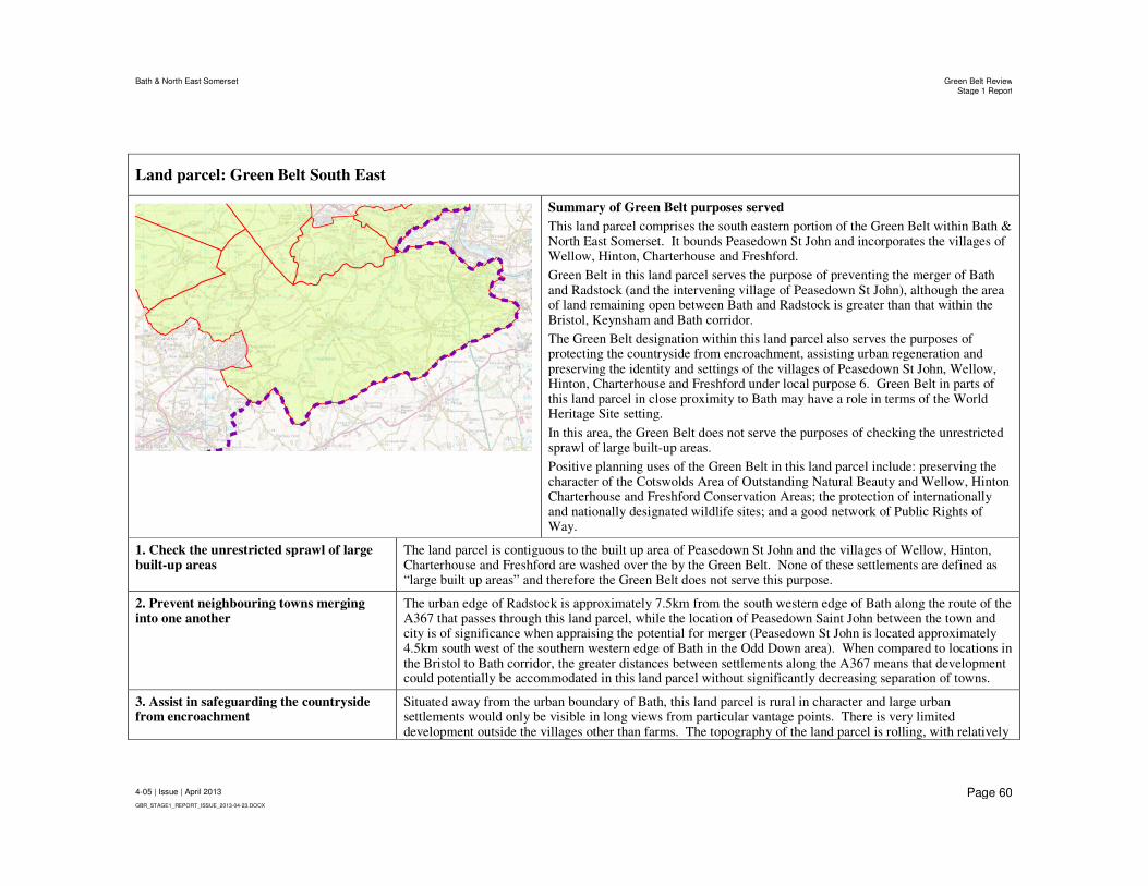
Bath & North East Somerset Green Belt ReviewStage 1 Report
4-05 | Issue | April 2013
GBR_STAGE1_REPORT_ISSUE_2013-04-23.DOCX
Page 60
Land parcel: Green Belt South East
Summary of Green Belt purposes served
This land parcel comprises the south eastern portion of the Green Belt within Bath & North East Somerset. It bounds Peasedown St John and incorporates the villages of Wellow, Hinton, Charterhouse and Freshford.
Green Belt in this land parcel serves the purpose of preventing the merger of Bath and Radstock (and the intervening village of Peasedown St John), although the area of land remaining open between Bath and Radstock is greater than that within the Bristol, Keynsham and Bath corridor.
The Green Belt designation within this land parcel also serves the purposes of protecting the countryside from encroachment, assisting urban regeneration and preserving the identity and settings of the villages of Peasedown St John, Wellow, Hinton, Charterhouse and Freshford under local purpose 6. Green Belt in parts of this land parcel in close proximity to Bath may have a role in terms of the World Heritage Site setting.
In this area, the Green Belt does not serve the purposes of checking the unrestricted sprawl of large built-up areas.
Positive planning uses of the Green Belt in this land parcel include: preserving the character of the Cotswolds Area of Outstanding Natural Beauty and Wellow, Hinton Charterhouse and Freshford Conservation Areas; the protection of internationally and nationally designated wildlife sites; and a good network of Public Rights of Way.
1. Check the unrestricted sprawl of large built-up areas
The land parcel is contiguous to the built up area of Peasedown St John and the villages of Wellow, Hinton, Charterhouse and Freshford are washed over the by the Green Belt. None of these settlements are defined as “large built up areas” and therefore the Green Belt does not serve this purpose.
2. Prevent neighbouring towns merging into one another
The urban edge of Radstock is approximately 7.5km from the south western edge of Bath along the route of the A367 that passes through this land parcel, while the location of Peasedown Saint John between the town and city is of significance when appraising the potential for merger (Peasedown St John is located approximately 4.5km south west of the southern western edge of Bath in the Odd Down area). When compared to locations in the Bristol to Bath corridor, the greater distances between settlements along the A367 means that development could potentially be accommodated in this land parcel without significantly decreasing separation of towns.
3. Assist in safeguarding the countryside from encroachment
Situated away from the urban boundary of Bath, this land parcel is rural in character and large urban settlements would only be visible in long views from particular vantage points. There is very limited development outside the villages other than farms. The topography of the land parcel is rolling, with relatively

Bath & North East Somerset Green Belt ReviewStage 1 Report
4-05 | Issue | April 2013
GBR_STAGE1_REPORT_ISSUE_2013-04-23.DOCX
Page 61
Land parcel: Green Belt South East
steep hills forming the valleys of the Cam Brook, Wellow Brook and River Avon. Peasedown St John is located on high ground above the Cam Brook, with some development descending the hillside in the direction of Carlingcott to the northwest. The land parcel covers a large area of countryside within Bath & North East Somerset and therefore the Green Belt strongly serves this purpose.
A. Landscape value and enhancement and visual amenity
Approximately half of the land parcel, to the northwest of Wellow, is located in the Cotswold Area of Outstanding Natural Beauty.
In addition, the entirety of Wellow and large parts of Hinton Charterhouse and Freshford are designated as Conservation Areas and the Green Belt designation helps to protect the rural settings of these settlements. There are also concentrations of listed buildings at Wellow (incl. Grade I listed Parish Church of St Julian and Grade II* listed Dovecote, Manor House and Wellow House), Hinton Charterhouse (incl. Grade II* listed Hinton House and Church of St John the Baptist), and Freshford (incl. Grade II* listed Manorthorpe and Gardenthorpe, Parish Church of St Peter and Freshford Manor). There is also a grouping of Grade I listed buildings at Hinton Priory, located between Hinton Charterhouse and Freshford.
B. Biodiversity value and enhancement Cleaves Wood, located to the southeast of Wellow, is a Site of Special Scientific Interest (SSSI) and forms part of the Bath & Bradford on Avon Special Area of Conservation (SAC). There are also numerous Sites of Nature Conservation Interest within the land parcel.
C. Access and opportunities for outdoor sport and recreation
There is a good network of Public Rights of Way through the land cell, including a section of the Limestone Link path which follows the Cam and Midford Brooks.
4. To preserve the special character of historic towns
This land parcel does not adjoin a town, however, the Green Belt in parts of this land parcel in close proximity to Bath may have a role in terms of the World Heritage Site setting.
5. To assist in urban regeneration, by encouraging the recycling of derelict and other urban land
As this land parcel is not located directly adjacent to Bristol and Bath, it is not subject to the same level of development pressure as land directly on the edges of these urban areas, although there is still significant development pressure along the route of the A367 between Bath and Radstock. Therefore, the Green Belt in this land parcel serves this purpose.
6. (Local Purpose) To preserve the individual character, identity and setting of Keynsham and the villages and hamlets within the Green Belt.
The Green Belt in this land parcel protects the individual character, identity and settings of Peasedown St John and incorporates the villages of Wellow, Hinton, Charterhouse and Freshford.
Comparison with SWRA Review (2006) Conclusions
SWRA Location Reference V – Dunkerton area. This study and the SWRA Review both conclude that the Green Belt in this area serves the purposes of preventing merger and safeguarding the countryside from encroachment.
Bath & North East Somerset Green Belt ReviewStage 1 Report
4-05 | Issue | April 2013
GBR_STAGE1_REPORT_ISSUE_2013-04-23.DOCX
Page 62
7 Summary and Conclusions
Approach to Green Belt Review
The purpose of this Green Belt Review has been to undertake a comprehensive appraisal of the purposes served by the Green Belt within the Bath & North East Somerset (B&NES) administrative area. In June 2011 the Planning Inspector published ‘Preliminary Conclusions on Strategic Matters and Way Forward’ (ID/28) in the relation to the B&NES Core Strategy and recommended that evidence base work may involve a “…review of the Green Belt’s capacity to accommodate further development in a sustainable manner” (paragraph 7). Responding to the Inspector’s recommendations, this study seeks to: provide a comprehensive review of the Green Belt; see whether all land so designated fulfils clear Green Belt purposes; and appraise the degree of significance which should be attached to various parts of the Green Belt.
What the Green Belt Review does not seek to do is balance Green Belt purposes with sustainability objectives and therefore reach conclusions on whether there should be amendments to the Green Belt boundaries. This is the role for the Council to perform taking account of other evidence base work including the Sustainability Appraisal. With this in mind a discursive approach to presenting the role of the Green Belt in each area has been adopted, rather than an approach of scoring areas of land that can oversimplify the range of factors that decision-makers must eventually take into consideration.
To undertake the review the area of B&NES covered by the Green Belt designation has been divided into a series of land parcels. Each of these land parcels has been appraised having regard to the five ‘national’ Green Belt purposes set out in the National Planning Policy Framework (NPPF, March 2012). This appraisal has been undertaken within the context of the original reasons for the designation of the Bristol and Bath Green Belt. In addition, a sixth ‘local’ purpose has also been appraised to reflect these local reasons and adopted Local Plan and proposed Core Strategy policy. This sixth purpose relates to the role of the Green Belt in preserving the identity and setting of Keynsham and the villages and hamlets in the District. The land parcels appraisals are presented in a succinct manner to inform Council Members and officers about the characteristics of each land parcel and the Green Belt purposes served so that these can be considered during the decision-making process.
Conclusions
The fundamental aim of Green Belt policy ‘…is to prevent urban sprawl by keeping land permanently open’ (NPPF, paragraph 79) and an overall conclusion is that all parts of the current Bristol and Bath Green Belt designation contribute to this aim. Each of the land parcels appraised serve national Green Belt purposes and all serve local purpose 6, which seeks to safeguard the settings of villages and hamlets.
This review seeks to inform judgements on the degree of significance that should be attributed to various parts of the Green Belt. In order to do this in summary

Bath & North East Somerset Green Belt ReviewStage 1 Report
4-05 | Issue | April 2013
GBR_STAGE1_REPORT_ISSUE_2013-04-23.DOCX
Page 63
form, the Green Belt designation can be divided into five broad areas, as illustrated in the map at Appendix A2 and described below:
1. North and west of Keynsham - To the north and west of Keynsham there is only a very narrow Green Belt gap remaining between Bristol and Keynsham. In this area the Green Belt is of fundamental importance for preventing the unrestricted sprawl of Bristol, preventing the merger of the city with the town of Keynsham and redirecting development pressure from the urban fringe towards the regeneration areas in South Bristol. Preventing the merger of Bristol, Keynsham, Saltford and Bath was an original intention of the Green Belt designation in 1957 and this area of the Green Belt is of the highest importance if this objective is to continue to be achieved.
The Green Belt in this area is also of importance for protecting the countryside and preventing the coalescence of the village of Whitchurch with the large built-up area of Bristol. The Green Belt in this area is not of importance for preserving the setting of an historic town, with the exception of relatively small areas around the north of Keynsham that provide the setting for the historic town centre designated as a Conservation Area.
2. East of Keynsham/Around Saltford – The Green Belt around Saltford is of high importance for preventing the merger of the ‘towns’ of Bristol, Keynsham and Bath along the A4 transport corridor. It is acknowledged that the village of Saltford is not attributed the same status under purpose 2 (which relates to towns only) and the Green Belt gap between Keynsham and Bath is greater than that remaining between Bristol and Keynsham. Nevertheless it is clear that, by virtue of its location, the expansion of the village or potential merger with Keynsham would have important consequences for the integrity of the Green Belt in this location and undermine an original intention of the Green Belt designation.
The Green Belt in this area is also of importance for protecting the countryside, assisting urban regeneration, and preserving the original identity and setting of Saltford under local purpose 6. It is noteworthy that the north western part of Saltford is designated as a Conservation Area, however, the Green Belt in this area does not preserve the setting of a historic town.
3. West of Bath – The Green Belt prevents the unrestricted sprawl of the large built-up area of Bath and prevents the merger of the city of Bath with the town of Keynsham and village of Saltford. This is of particular importance as preventing the merger of Bristol, Keynsham, Saltford and Bath was an original intention behind the designation of the Bristol and Bath Green Belt. Given the status of Bath as a World Heritage Site, a prominent role of the Green Belt in this area is to preserve the special character of a historic town. The Green Belt in this area also assists in directing development pressure towards regeneration sites within the city and helps to protect the countryside.
4. Around the remainder of Bath – Given the status of Bath as a World Heritage Site, the role of the Green Belt in preserving the setting of a historic town comes to prominence, although the designation fulfils all six purposes around much of the city. The Green Belt prevents the unrestricted sprawl of the large built-up area of Bath and helps to prevent the merger of towns. The high importance of the Bristol to Bath corridor is referred to above, however it should also be highlighted that the remaining width of the Green Belt gap between Bath and Bradford on Avon is similar to that between Keynsham and Bath. Green Belt to the south of

Bath & North East Somerset Green Belt ReviewStage 1 Report
4-05 | Issue | April 2013
GBR_STAGE1_REPORT_ISSUE_2013-04-23.DOCX
Page 64
Bath also prevents the potential for ribbon development along the A367 and eventual potential merger with Radstock (and Peasedown St John), so it is only to the north of the city that the designation does not serve this purpose.
The Green Belt around Bath also assists in directing development pressure
towards regeneration sites within the city and helps to protect the countryside,
while it is noted that development around Claverton Down is of a peri-urban
character in some places.
5. Southern Green Belt – Consistent with recommendations that Green Belt designations should be several kilometres wide, the Green Belt within Bath & North East Somerset extends across a large area of countryside to the south of Bristol, Keynsham, Saltford and Bath. The Green Belt in this area is of most importance for protecting the countryside and preserving the setting and separate identities of villages. By limiting the potential for the expansion of villages in rural areas, the Green Belt in this broader rural area also assists in deflecting development pressure back to urban regeneration areas, while acknowledging that the pressure for development is not as great as at the urban fringe.

Appendix A
Maps

Bath & North East Somerset Green Belt ReviewStage 1 Report
4-05 | Issue | April 2013
GBR_STAGE1_REPORT_ISSUE_2013-04-23.DOCX
Page A1
A1 Green Belt Land Parcels


Job No
227756-00
Drawing No Issue
001 P1
Drawing Status
Preliminary
Job Title
Client
63 St Thomas StreetBristol, BS1 6JZ United KingdomTel +44 (0)117 976 5432 Fax +44 (0)117 976 5433www.arup.com
0 2.5 51.25
Kilometers
Legend
B&NES Boundary
B&NES Sustainability Appraisal Land Parcels
Green Belt
!°
© Arup
B&NES
Green Belt Review
A3
\\Global\Europe\Bristol\Jobs\227xxx\227756-00\4.30_Drgs\2_GIS\02 Map Documents\Green Belt v2.mxd
13/0
2/20
13 1
7:50
:48
Green Belt Land Parcels
Scale at A3
1:100,000
Issue Date By Chkd Appd
P1 2013-02-13 JS NM-D N-MDLand Parcel for Green Belt Review purposes onlyLand Parcel not used for Sustainability Appraisal
Land Parcel for Green Belt Review purposes onlyLand Parcel not used for Sustainability Appraisal
Land Parcel for Green Belt Review purposes onlyLand Parcel not used for Sustainability Appraisal
002
B&NES Green Belt Review andSustainability Apraisal Land Parcels


Bath & North East Somerset Green Belt ReviewStage 1 Report
4-05 | Issue | April 2013
GBR_STAGE1_REPORT_ISSUE_2013-04-23.DOCX
Page A2
A2 Green Belt Summary Map


Job No
227756-00
Drawing No Issue
001 P1
Drawing Status
Preliminary
Job Title
Client
63 St Thomas StreetBristol, BS1 6JZ United KingdomTel +44 (0)117 976 5432 Fax +44 (0)117 976 5433www.arup.com
0 2.5 51.25
Kilometers
Legend
B&NES Boundary
B&NES Sustainability Appraisal Land Parcels
Green Belt
!°
© Arup
B&NES
Green Belt Review
A3
\\Global\Europe\Bristol\Jobs\227xxx\227756-00\4.30_Drgs\2_GIS\02 Map Documents\Green Belt v2.mxd
13/0
2/20
13 1
7:50
:48
001
B&NES Green Belt Review andSustainability Apraisal Land Parcels
2
Green Belt Summary Areas
1. North and West of Keynsham2. East of Keynsham / Around Saltford3. West of Bath4. Around the remainder of Bath5. Southern Green Belt
This map illustrates the conclusions of the Green Belt Review having regard to broad summary areas. The boundaries of the summary areas are indicative only and should not be relied upon as precise delineations of land.
Green Belt Review Summary Map
Bristol
Whitchurch
Keynsham
Bath
Saltford
Radstock
Peasdown St John
BishopSutton
MidsomerNorton
CluttonHighLittleton
Timsbury
Paulton
Farmborough
5
1 3
4
Settlement boundaries