GUERILLA PLACEMAKING. …BRINGS VACANT OR UNDERUSED PLACES TO LIFE GUERILLA PLACEMAKING…
Bath and North East Somerset Placemaking Plan DPD
Sustainability Appraisal Scoping Report
Annex B: Baseline Data
Date: April 2017

Bath and North East Somerset Council SA Scoping Report Annex B
B&NES District - Baseline data
SA topic Data and quantified information
Comparators or targets Trend and notes Reference
Objective 1: Improve the health and well-being of all communities
Life expectancy at birth in B&NES is 81.3 years for males and 84.7 years for females (2012-14)
For males, this was higher than the South West (80.2 years) and England (79.6 years) averages
For females, this was higher than the South West (83.9 years) and England (83.2) averages
Life expectancy is 8.6 years lower for men and 4.7 years lower for women in the most deprived areas of Bath and North East Somerset than in the least deprived areas
In Year 6, 15.8% (245) of children are classified as obese, better than the average for England
Levels of teenage pregnancy, GCSE attainment, breastfeeding and smoking at time of delivery are better than the England average
In 2015, the health of people in Bath and North East Somerset is generally better than the England average
Deprivation is lower than average, however about 12.0% (3,400) children live
Life expectancy has increased by about 1.5 and 3 years for women and men respectively since 2001
Levels of regular participation in sport has fallen for 2 years in a
row
On the whole, life expectancy
is increasing; for women and
for most men
The life expectancy of men in
our ‘most deprived’
communities isn’t improving
Public Health England (2015) (accessed 24.03.2017)
Bath and North East Somerset Council (2015) Life Expectancy
Public Health England (2015) Segmenting Life Expectancy Gaps by Cause of Death Census (2011)
Office of National Statistics, Crown Copyright (2012) 2011 Census data
Office of National Statistics, Crown Copyright (2012) In house analysis of 2011 Census data
Sport England Active People Survey (2015)
http://www.sportengland.org/research/whoplays-sport/

Bath and North East Somerset Council SA Scoping Report Annex B
in poverty
The aging population will impact upon future healthcare provision
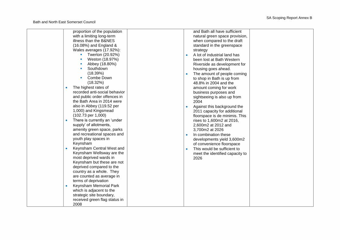
In 2011 five wards in the Bath Area had a higher proportion of the population with a limiting long-term illness than the B&NES (16.08%) and England & Wales averages (17.92%):
Twerton (20.92%)
Weston (18.97%) Abbey (18.80%) Southdown
(18.39% Combe Down
(18.32%)
There are 14 GPs surgeries across the area and a medical centre at the University of Bath
In 2014/2015, 41.9% of adults (16+) participated in sport at least once per week in B&NES. In 2013/2014, the figure was 44.9%, for 2012/2013 it was 45.9% and for 2011/2012, it was 42.2%
Safe places to play are a key identified issue for young people in the area
Objective 2: Meet identified needs for sufficient, high quality housing
High house prices and a lack of affordable housing in the District make it difficult to attract people to the area and to retain key workers
In 2016 the ratio of house prices to average earnings was 11 in B&NES, higher than the ratio for England (10.2)
There are 21,000 new households formed in 2015/16 however less than 19,000 homes were built in the south west in 2015
B&NES HEELA (2017)
Home Truths 2016/17: South
West (2016) Annual
Monitoring Report (2016)
Homelessness Strategy
Bath and North East Somerset Council SA Scoping Report Annex B
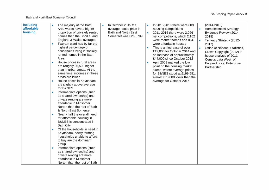
including affordable housing
The majority of the Bath Area wards have a higher proportion of privately rented homes than the B&NES and England & Wales averages
Twerton ward has by far the highest percentage of households living in socially rented homes in the Bath Area
House prices in rural areas are roughly £6,500 higher than in urban areas. At the same time, incomes in these areas are lower
House prices in Keynsham are slightly above average for B&NES
Intermediate options (such as shared ownership) and private renting are more affordable in Midsomer Norton than the rest of Bath & North East Somerset
Nearly half the overall need for affordable housing in B&NES is concentrated in Bath City
Of the households in need in Keynsham, newly forming households unable to afford to buy are the dominant group
Intermediate options (such as shared ownership) and private renting are more affordable in Midsomer Norton than the rest of Bath
In October 2015 the average house price in Bath and North East Somerset was £268,709
In 2015/2016 there were 809 housing competitions
2011-2016 there were 3,026 net competitions, which 2,162 were market homes and 864 were affordable houses
This is an increase of over £12,000 for October 2014 and an increase of approximately £44,000 since October 2012
April 2009 marked the low point on the housing market slump, where average prices for B&NES stood at £199,681, almost £70,000 lower than the average for October 2015
(2014-2018)
Homelessness Strategy
Evidence Review (2014-
2018)
Tenancy Strategy (2012-
2017)
Office of National Statistics,
Crown Copyright (2012) In
house analysis of 2011
Census data West of
England Local Enterprise
Partnership
Bath and North East Somerset Council SA Scoping Report Annex B
& North East Somerset
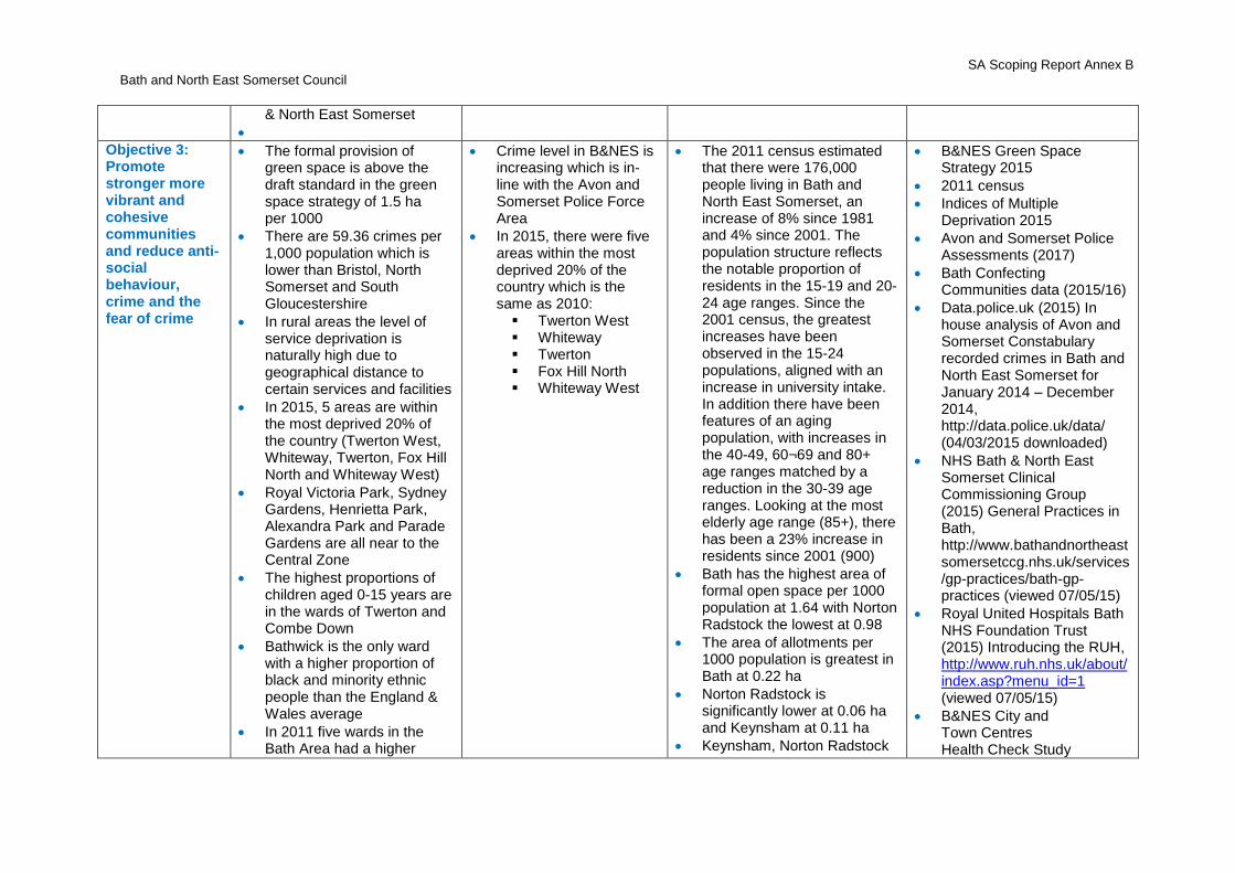
Objective 3: Promote stronger more vibrant and cohesive communities and reduce anti-social behaviour, crime and the fear of crime
The formal provision of green space is above the draft standard in the green space strategy of 1.5 ha per 1000
There are 59.36 crimes per 1,000 population which is lower than Bristol, North Somerset and South Gloucestershire
In rural areas the level of service deprivation is naturally high due to geographical distance to certain services and facilities
In 2015, 5 areas are within the most deprived 20% of the country (Twerton West, Whiteway, Twerton, Fox Hill North and Whiteway West)
Royal Victoria Park, Sydney Gardens, Henrietta Park, Alexandra Park and Parade Gardens are all near to the Central Zone
The highest proportions of children aged 0-15 years are in the wards of Twerton and Combe Down
Bathwick is the only ward with a higher proportion of black and minority ethnic people than the England & Wales average
In 2011 five wards in the Bath Area had a higher
Crime level in B&NES is increasing which is in-line with the Avon and Somerset Police Force Area
In 2015, there were five areas within the most deprived 20% of the country which is the same as 2010:
Twerton West Whiteway Twerton Fox Hill North Whiteway West
The 2011 census estimated that there were 176,000 people living in Bath and North East Somerset, an increase of 8% since 1981 and 4% since 2001. The population structure reflects the notable proportion of residents in the 15-19 and 20-24 age ranges. Since the 2001 census, the greatest increases have been observed in the 15-24 populations, aligned with an increase in university intake. In addition there have been features of an aging population, with increases in the 40-49, 60¬69 and 80+ age ranges matched by a reduction in the 30-39 age ranges. Looking at the most elderly age range (85+), there has been a 23% increase in residents since 2001 (900)
Bath has the highest area of formal open space per 1000 population at 1.64 with Norton Radstock the lowest at 0.98
The area of allotments per 1000 population is greatest in Bath at 0.22 ha
Norton Radstock is significantly lower at 0.06 ha and Keynsham at 0.11 ha
Keynsham, Norton Radstock
B&NES Green Space Strategy 2015
2011 census
Indices of Multiple Deprivation 2015
Avon and Somerset Police Assessments (2017)
Bath Confecting Communities data (2015/16)
Data.police.uk (2015) In house analysis of Avon and Somerset Constabulary recorded crimes in Bath and North East Somerset for January 2014 – December 2014, http://data.police.uk/data/ (04/03/2015 downloaded)
NHS Bath & North East Somerset Clinical Commissioning Group (2015) General Practices in Bath, http://www.bathandnortheastsomersetccg.nhs.uk/services/gp-practices/bath-gp-practices (viewed 07/05/15)
Royal United Hospitals Bath NHS Foundation Trust (2015) Introducing the RUH, http://www.ruh.nhs.uk/about/index.asp?menu_id=1 (viewed 07/05/15)
B&NES City and Town Centres Health Check Study
Bath and North East Somerset Council SA Scoping Report Annex B
proportion of the population with a limiting long-term illness than the B&NES (16.08%) and England & Wales averages (17.92%):
Twerton (20.92%) Weston (18.97%) Abbey (18.80%) Southdown
(18.39%) Combe Down
(18.32%)
The highest rates of recorded anti-social behavior and public order offences in the Bath Area in 2014 were also in Abbey (119.52 per 1,000) and Kingsmead (102.73 per 1,000)
There is currently an ‘under supply’ of allotments, amenity green space, parks and recreational spaces and youth play spaces in Keynsham
Keynsham Central West and Keynsham Wellsway are the most deprived wards in Keynsham but these are not deprived compared to the country as a whole. They are counted as average in terms of deprivation
Keynsham Memorial Park which is adjacent to the strategic site boundary, received green flag status in 2008
and Bath all have sufficient natural green space provision, when compared to the draft standard in the greenspace strategy
A lot of industrial land has been lost at Bath Western Riverside as development for housing goes ahead.
The amount of people coming to shop in Bath is up from 48.8% in 2004 and the amount coming for work business purposes and sightseeing is also up from 2004
Against this background the 2011 capacity for additional floorspace is de minimis. This rises to 1,600m2 at 2016, 2,600m2 at 2012 and 3,700m2 at 2026
In combination these developments yield 3,600m2 of convenience floorspace
This would be sufficient to meet the identified capacity to 2026
Bath and North East Somerset Council SA Scoping Report Annex B
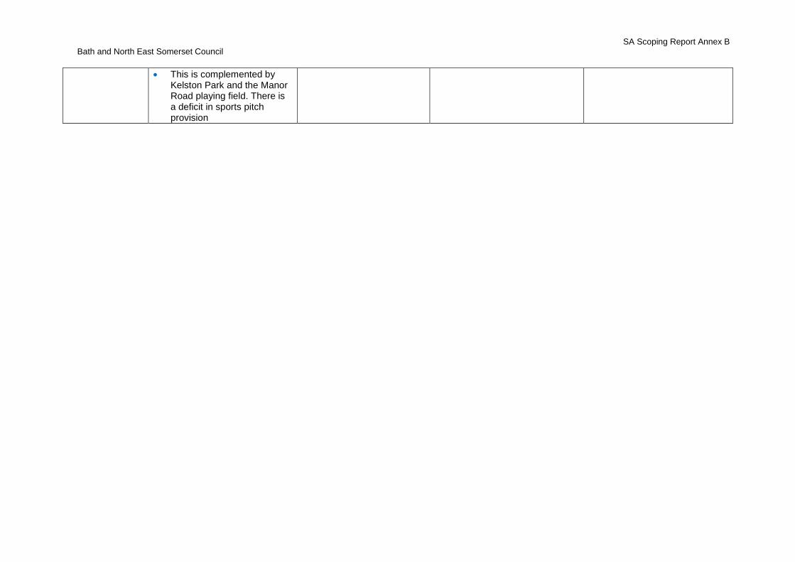
This is complemented by Kelston Park and the Manor Road playing field. There is a deficit in sports pitch provision
Bath and North East Somerset Council SA Scoping Report Annex B
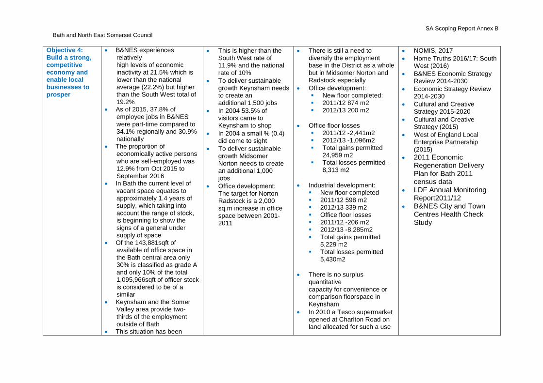
Objective 4: Build a strong, competitive economy and enable local businesses to prosper
B&NES experiences relatively high levels of economic inactivity at 21.5% which is lower than the national average (22.2%) but higher than the South West total of 19.2%
As of 2015, 37.8% of employee jobs in B&NES were part-time compared to 34.1% regionally and 30.9% nationally
The proportion of economically active persons who are self-employed was 12.9% from Oct 2015 to September 2016
In Bath the current level of vacant space equates to approximately 1.4 years of supply, which taking into account the range of stock, is beginning to show the signs of a general under supply of space
Of the 143,881sqft of available of office space in the Bath central area only 30% is classified as grade A and only 10% of the total 1,095,966sqft of officer stock is considered to be of a similar
Keynsham and the Somer Valley area provide two-thirds of the employment outside of Bath
This situation has been
This is higher than the South West rate of 11.9% and the national rate of 10%
To deliver sustainable growth Keynsham needs to create an additional 1,500 jobs
In 2004 53.5% of visitors came to Keynsham to shop
In 2004 a small % (0.4) did come to sight
To deliver sustainable growth Midsomer Norton needs to create an additional 1,000 jobs
Office development: The target for Norton Radstock is a 2,000 sq.m increase in office space between 2001- 2011
There is still a need to diversify the employment base in the District as a whole but in Midsomer Norton and Radstock especially
Office development: New floor completed: 2011/12 874 m2 2012/13 200 m2
Office floor losses 2011/12 -2,441m2 2012/13 -1,096m2 Total gains permitted
24,959 m2 Total losses permitted -
8,313 m2
Industrial development: New floor completed 2011/12 598 m2 2012/13 339 m2 Office floor losses 2011/12 -206 m2 2012/13 -8,285m2 Total gains permitted
5,229 m2 Total losses permitted
5,430m2
There is no surplus quantitative capacity for convenience or comparison floorspace in Keynsham
In 2010 a Tesco supermarket opened at Charlton Road on land allocated for such a use
NOMIS, 2017
Home Truths 2016/17: South West (2016)
B&NES Economic Strategy Review 2014-2030
Economic Strategy Review 2014-2030
Cultural and Creative Strategy 2015-2020
Cultural and Creative Strategy (2015)
West of England Local Enterprise Partnership (2015)
2011 Economic Regeneration Delivery Plan for Bath 2011 census data
LDF Annual Monitoring Report2011/12
B&NES City and Town Centres Health Check Study
Bath and North East Somerset Council SA Scoping Report Annex B
exacerbated by major factory closures including Cadbury in Keynsham
Keynsham has been particularly affected by the closure of Cadbury which has seen the town’s relatively small employment base reduce by 11%
A farmers market is held in Bath every Saturday at Green Park Station
Bath has a strong local further and higher education sector, as well as excellent local training providers.
Employment in Bath is dominated by the public sector
Retail and tourism are also key employment sectors in Bath resulting in many low skilled and / or low wage jobs
There has been a net loss of office and industrial space in Bath. This is against target for an increase office space
Keynsham has a limited employment base of about 3,500 full time equivalent jobs (2008) which is dominated by distribution (a reflection of good transport links), public administration and business services. The Cadbury factory accounted for 10% of local employment.
in the Local Plan. The net sales area is 1,882m2 of which 1,600m2 is for convenience goods. The store is estimated to turnover at £20.5m a year
Bath and North East Somerset Council SA Scoping Report Annex B
Keynsham is ideally located to play a significant role in supporting sustainable economic growth across the District
Keynsham suffers from a lack of available modern business space, the High Street has seen little regeneration over the past decade and it has recently seen the closure of the Cadbury Somerdale site
Keynsham has a population of over 16,000, making it one of the largest urban areas in the district, although over half the resident working population
Bath and North East Somerset Council SA Scoping Report Annex B
Objective 5: Ensure everyone has access to high quality and affordable public transport and promote cycling and walking
The high level of self-containment in Bath and easy access to a mainline railway station does not prevent heavy traffic congestion during the day, perceived to have a negative impact on businesses in the City. Congestion and journey time delays affect rural communities as well as urban areas
The majority of the Bath Package has been completed, including two Park & Ride expansions
The Newbridge Park and Ride expansion was finished March in 2015
There is no direct link to the motorway network in B&NES and Bath suffers particularly from the sub-region’s poor internal transport links
The majority of the wards in the Bath Area have a higher proportion of households with no vehicles than the B&NES and England & Wales averages
Although Keynsham has a railway station, during the day fast services to Bristol and Bath do not stop and the links from the railway station to the High Street are poor
There is a high level of car ownership in Keynsham for
On average nearly 50,000 cars enter Bath every day and the Government expects this to increase by 15% over the next 10 years
There have been increases to the capacity of the Parks and Rides in Bath from 1,990 to 2,860. An additional 230 spaces have been provided in Odd Down Park and Ride (completed in 2012), an additional 390 spaces in Landsdown Park and Ride (completed February 2013) and an extra 248 spaces in Newbridge (completed July 2015)
Bus use and park and ride use is up in Bath in recent years
There has been sustained growth in cycling in the West of England area (which includes B&NES) in 2011/12 as Cycling City measures kick in Cycling in on track compared to target
In 2009/10 the number of bus users unfortunately fell, a reflection of continuing national economic difficulties but 2010/11 saw a welcome recovery and this continued in 2011/12 with patronage slightly above the target figure for that year
There has been a 2 to 3% fall in traffic across most inter-
West of England Local Transport Plan: Progress Report 2016
West of England Joint Local Transport Plan 3 (2011-2026)
2016 Progress Report on the Joint Local Transport Plan 3 (2016)
Bath and North East Somerset Council (2013) JSNA - Socio-Economic Inequality: Presentation to Wellbeing Policy Development & Scrutiny Panel http://www.bathnes.gov.uk/sites/default/files/soci-oeconomic_inequality_presentation_jan_2013.pdf
Bath and North East Somerset Council SA Scoping Report Annex B
an urban area with good bus links and a mainline rail service
More than 60% of people in Keynsham commute elsewhere to work
The A4 through Keynsham is subject to high levels of congestion. The levels of traffic in the High Street are not a cause for concern in itself. However, there is significant queuing along the High Street at all times of day and this impacts upon the town centre environment
Many road junctions are of poor quality including the junction of High Street and Bath Hill and the junction of Temple Street and Rock Road
Although Keynsham has a railway station, during
the day fast services to Bristol and Bath do not stop and the links from the railway station to the High Street are poor
Only 2% of residents travel to work by train
Keynsham is served by the following bus services: 42 Keynsham – Bristol 134 Knowle (Broad
Walk) to Kingswood (John Cabot Academy)
178 (678) Bath -
urban key corridors Congestion will cost the West
of England economy £600m 2016.
Since 2000, traffic levels have fallen on the Bath road network inner cordon and remained fairly constant on the outer cordon
In the last two years there has been a 10% fall in traffic on some routes in Bath, which the council believes is a result of recessionary effects
Bath and North East Somerset Council SA Scoping Report Annex B
Midsomer Norton – Bristol
318 Keynsham - Cribbs Causeway
337 Bath - Keynsham (Park Estate)
338 Bath – Bristol 339 Bath – Bristol 349 Bristol - Keynsham
(Park Estate) 442 Bristol (St Phillips)
to Newbridge (Oldfield School)
507 Keynsham to Bristol (Southmead Hospital)
533 Keynsham Mangotsfield
636 Keynsham – Whitchurch
640 Bishop Sutton to Keynsham
665 Keynsham & Saltford Local Service
668 Midsomer Norton to Bristol
678 Bristol to Writhlington
683 Keynsham to Wells 684 Keynsham - Wick A14 Keynsham to
Longwell Green (Asda) T3 Keynsham to
Brislington (Tesco)
There is a high level of car ownership in Keynsham for an urban area with good bus links and a mainline rail service.
Bath and North East Somerset Council SA Scoping Report Annex B
More than 60% of people in Keynsham commute
elsewhere to work
The A4 through Keynsham is subject to high levels of congestion
The levels of traffic in the High Street are not a cause for concern in itself. However, there is significant queuing along the High Street at all times of day and this impacts upon the town centre environment
Many road junctions are of poor quality including the junction of High Street and Bath Hill and the junction of Temple Street and Rock Road
Midsomer Norton and Radstock are served by the following bus services:
173 Bath – Wells 184 Bath – Frome 178 (678) Bath -
Midsomer Norton – Bristol
179 Bath - Midsomer Norton
185 Paulton - Trowbridge
379 Radstock - Bristol 414 Midsomer Norton
- Frome 424 Midsomer Norton
– Frome 668 Midsomer Norton
Bath and North East Somerset Council SA Scoping Report Annex B
- Bristol 678 Bristol –
Writhlington 754 Bishop Sutton -
Radstock 757 Bath (Odd Down)
- Midsomer Norton (Tesco)
768 Hinton Blewitt – Bath
776 Radstock - Shepton Mallet
777 Radstock - Midsomer Norton (Tesco)
782 Paulton –Tyning 789 Blagdon to
Radstock 791 Bath to Midsomer
Norton
There is a feeling of vehicles dominating in the
Midsomer Norton High Street. The priority is to address specific traffic pressure points, such as the Excelsior Terrace junction and the island junction
High levels of out-commuting from Midsomer Norton
and Radstock means that the link road south from Bath to Keynsham, Midsomer Norton and Radstock copes with high levels of commuter traffic
Radstock centre
Bath and North East Somerset Council SA Scoping Report Annex B
experiences traffic congestion
Objective 6: Protect and enhance local environmental distinctiveness
There are 2 Areas of Outstanding Natural Beauty in the District - Mendip and Cotswolds AONBs
The district has a varied landscape represented by 18 LCAs
61% of B&NES is Green Belt
Bath has a distinctive townscape in the way that buildings respond to the distinct topography
Bath was designated as a World Heritage site in 1987
There are 11 Historic Parks and Gardens in Bath
The character of Keynsham, Norton-Radstock and the villages are enriched and partly defined by the landscapes which surround and in some cases penetrate the built up areas
The High Street is of mixed townscape
quality
There is high quality development in some areas such as the Church and the Manor House. However, the core of the High Street is of low quality
Keynsham is in the Avon Valley Landscape Character Area
The landscape consists
The landscape designations and the general landscape and townscape character of the District have not changed although there are still threats to the character of the District from increasing traffic and development, for example
Mendip Hills AONB Management Plan 2014-2019
Cotswolds AONB Management Plan 2013-2018
Landscapes for life.org.uk (accessed 2016/2017)
World Heritage Setting website (2017)
Bathscape website (2017)
B&NES Planning and Conservation Team (2017)
B&NES Keynsham Conservation Area Appraisal and Management Plan (2016)
Rural Landscapes of Bath and North East Somerset-A Landscape Character Assessment SPD 2003

Bath and North East Somerset Council SA Scoping Report Annex B
primarily of the meandering River Avon and its wide valley with a generally flat or gently sloping valley floor
Two significant waterways: the River Avon and the Kennet and Avon Canal, along with Chew Valley and Blagdon Lakes are important landscape features and resources for recreational uses
The Chew Valley Lake is an important landscape feature and wildlife habitat within the Mendip Hills AONB
The Midsomer Norton and Welton Conservation Area is currently on the Heritage at Risk Register
The Radstock (including Braysdown and Clandown) Conservation Area is also currently on the Heritage
Objective 7: Protect and enhance the district’s historic, environmental and cultural assets
Bath was designated as a World Heritage site in 1987
There are 37 Conservation Areas, 11 Historic Parks and Gardens, 84 SAMs and approximately 6,400 listed buildings and structures in B&NES (of which 5,000 lie within the City of Bath)
There are 3 conservation areas, 8 Scheduled Monuments, grade I / II* listed buildings entries on the national heritage at risk
There are 3 conservation areas, 8 Scheduled Monuments, grade I / II* listed buildings entries on the national heritage at risk
Since 2013, seven conservation areas have been removed from the register
The two Keynsham Conservation Areas were merged in 2016 to form a new larger conservation area called the ‘Keynsham Conservation’
Historic England - Heritage at Risk Register
B&NES website (accessed 02.02.2017)
World Heritage Setting
B&NES Core Strategy (2011-2029)
B&NES Placemaking Plan (2011-2029)
B&NES Keynsham Conservation Area Appraisal and Management Plan (2016)
Historic England (2017)
Bath and North East Somerset Council SA Scoping Report Annex B
at Risk Register.register
The area which was formerly part of the Somerset coalfield retains a rich industrial heritage
Bath has a distinctive townscape in the way that buildings respond to the distinct topography. Many buildings and terraces follow contours, often overlooking open ground and panoramic views
There is one conservation area in Keynsham after the Dapps Hill conservation area and Keynsham Town Conservation Area which was redrawn in 2016
Significant history and nationally important nearby Roman settlement of Traiectus
Considerable archaeological potential within the town and on the former Abbey lands
The town centre of Keynsham has many historic buildings but many of the old shops were replaced with modern units in the 1960s and 1970s and the High Street lacks vibrancy and coherence
High quality buildings are concentrated in the
B&NES Core Strategy (2011-2029)
B&NES Placemaking Plan (2011-2029)
Bath and North East Somerset Council SA Scoping Report Annex B
Church Street area
High rise council offices and the surrounding precinct are incongruous with the character and appearance of the town
Objective 8: Encourage and protect habitats and biodiversity and geodiversity (taking account of climate change)
There are no SSSIs in the Bath central zone
Combe Down & Bathampton Down Mines SSSI and Bath and Bradford upon Avon Bats SAC is about 3km from the central zone and about 6km from the Lower Bristol Road
This SSSI is in favourable condition.
Kensington Meadows Local Nature Reserve is 1.5 km from the Central Zone
North Road Quarry Geological SSSI is near to the Central Zone
Newton St Loe SSSI is just to the west of the Lower Bristol Road
Carrs Woodland Local Nature Reserve is to the immediate west of the Lower Bristol Road
Twerton Roundhill Local Nature Reserve is about 1km to the south of Lower Bristol Road
The rural areas includes the Chew Valley Lake which is a RAMSAR site and a Special
The suggestion is that winters will become wetter over the whole of the UK, by as much as 20% in the 2050’s
A shift in the seasonal pattern of rainfall is also expected, with summer and autumn becoming much drier than at present
The Regional Strategy for the South West Environment: sets the target to bring into favourable condition by 2010 95% of all nationally important wildlife sites
‘Change’ is considered in terms of the impact of completed development, management programmes and planning agreements
Measurement includes additions and subtractions to biodiversity priority habitats (hectares)
The landscape designations and the general landscape and townscape character of the District have not changed although there are still threats to the character of the District from increasing traffic and development
B&NES Landscape Character Assessment (2003)
B&NES Biodiversity and Geological Conservation Assessment website (assessed 02.01.17)
B&NES BAP 2017
B&NES Ecology Team (2017)
Bath and North East Somerset Council SA Scoping Report Annex B
Protection Area
Blagdon Lake is a SSSI
Approximately 30% of the area is covered the Forest of Avon
There are 11 geological sites of national importance
There are 11 Sites of Special Scientific Interest
There is also Browns Folly Candidate Special Areas of Conservation (cSACs)
Objective 9: Reduce land, water, air, light, noise pollution
Monitoring results of NO2 in 2015 were on average slightly lower than in 2014
There are three AQMAs identified in the district, all related to exceedance of NO²
These are: Bath Air Quality
Management Area Keynsham Air Quality
Management Area Saltford Air Quality
Management
Parts of the south of Bath to North Stoke, Bathampton, Combe Hay, Monkton Combe and Upper Swainswick and Chew Magna are Groundwater Source protection Zones
The Council declared an AQMA for nitrogen dioxide (NO2) along the A4 London Road (Bath). This has now been extended to cover an
The air quality objective for Nitrogen dioxide (NO²) are: (i) annual mean concentration levels of NO² do not exceed 40µg/m3; and (ii) hourly mean concentration levels of NO² do not exceed 200µg/m3 more than 18 times a calendar year
The area’s most at risk of flooding have not changed
Bath & North East Somerset Council has made a commitment to providing the leadership to help our communities to reduce carbon emissions across the area by 45% by 2026, in line with the national targets
Air quality in the Bath AQMA improved during 2011 compared to the previous year
The average level of nitrogen dioxide fell from 50 to 45 μg/ but levels still remain above the ‘objective’ of 40 μg/m3 set in the National Air Quality Strategy
Coal measures are present within B&NES, There are approximately 570 mine
Bath and North East Somerset Strategic Flood Risk Assessment (SFRA)
B&NES Food Strategy 2014-2017
B&NES the Environmental Sustainability & Climate Change Strategy (2016- 2020)
Bath and North East Somerset Strategic Flood Risk Assessment (SFRA)
B&NES Food Strategy 2014-2017
B&NES the Environmental Sustainability & Climate Change Strategy (2016- 2020)

Bath and North East Somerset Council SA Scoping Report Annex B
area which covers the major road network in Bath
Air Quality in Bath City Centre has been poor mainly due to emissions from vehicular traffic. In conjunction with this, the city’s topography restricts dispersion and results in higher pollutant concentrations
Hot springs have been, and continue to be, at the centre of economic, social and cultural developments in the City. As such, their protection is of paramount importance locally and nationally
entries
Objective 10: Reduce vulnerability to, and manage flood risk (taking account of climate change)
In the Bath & North East Somerset regional Surface Water Management Plan, Wessex Water identified postcode locations for 44 occurrences of sewer flooding incidents for the period 2013-2014, including those attributable to surface water flooding
There is thought to be 4,078 properties within B&NES at risk of surface water flooding
Large proportions of the Bath Central Zone and the Lower Bristol Road are in Flood Zone 3a and 3b (the highest risk)
The areas prone to flooding
The area’s most at risk of flooding have not changed
Bath & North East Somerset Council has made a commitment to
providing the leadership to help our communities to reduce carbon emissions across the area by 45% by
2026, in line with the
national targets
By 2050 average annual temperatures will increase by over 2%, summer rainfall will decrease by 20% and winter rainfall will increase by 17%
There is thought to be 4,078 properties within B&NES at risk of surface water flooding
High summer temperatures are becoming more frequent, and very cold winters are becoming increasingly rare
Winters are becoming wetter (a 5 - 20% increase is expected by the 2050s), whilst summers are becoming drier (10 - 40% decrease by the 2050s)
Bath and North East Somerset Strategic Flood Risk Assessment (SFRA)
B&NES Food Strategy 2014-2017 B&NES the Environmental Sustainability & Climate Change Strategy (2016- 2020)
Bath and North East Somerset Strategic Flood Risk Assessment (SFRA)
B&NES Food Strategy 2014-2017 B&NES the Environmental Sustainability & Climate Change Strategy (2016-
Bath and North East Somerset Council SA Scoping Report Annex B
tend to follow the main rivers.
The areas most at risk of flooding are: Bath -at risk of flooding
from rivers, sewers, surface water, artificial sources and to a lesser degree from groundwater (springs)
Keynsham -at risk of flooding from rivers (which may be tidally influenced), surface water, sewers and artificial source
Midsomer Norton/Radstock -at risk of flooding from rivers, surface water and sewers. Note: Midsomer Norton benefits from a flood alleviation scheme during a 1% AEP river flood event
Chew Magna and downstream communities -at risk of flooding from rivers, surface water and artificial sources
Global temperatures will rise between 1.4 – 5.5ºC over the 21st Century
MSN: A level 2 SFRA has been undertaken. This has shown that the town centre is in Flood Zone 1
2020)
Bath and North East Somerset Council SA Scoping Report Annex B
Small areas are at higher risk of flooding. Midsomer
Norton benefits from a flood alleviation scheme during a 1% AEP river flood event
Radstock: A level 2 SFRA has been undertaken
This has shown that some of the central parts of the
town centre are in Flood Zone 2 and 3a
Objective 11: Increase resilience to climate change
17.3% of B&NES households are living in fuel poverty; cold homes cost the local NHS an estimated £3.8m every year
Fuel poverty figures have risen as a result of rising fossil fuel prices
Climate change may reduce the need for winter heating, but will increase the need for summer cooling
The latest work on the Wessex Water, Water Resources Management Plan has not identified any areas of water supply demand deficit at this stage
The total amount of CO2 emissions in the district was 992 kilo-tonnes in 2010. Sources of greenhouse gas emissions in the district are (2010 data):
34% industrial 41% domestic 24% transport
B&NES potential for renewable energy generation by 2026:
165MW of renewable heat
110 megawatts (MW) of installed renewable electricity capacity
Since 2014 until 2016 there have been 102 homes in B&NES retrofitted for energy efficient
B&NES is a high performing recycling authorities within the country, recycling 52.6% of household waste in 2015/16
B&NES Waste Strategy Review 2014
Waste Strategy, statistics and health and safety website (2016)
Record of waste recycled, reused, recovered or composted
TOWARDS ZERO WASTE 2020 - A Waste Strategy for Bath & North East Somerset (2005)
Defra waste statistics
Bath and North East Somerset Council SA Scoping Report Annex B
1% other sources
There is no record of any major renewable energy schemes undertaken in the District
A renewable energy research study has been undertaken
Initiatives to improve energy efficiency and utilise renewable energy need to be addressed in relation to the historic building B&NES has two significant waterways: the River
Avon and the Kennet and Avon Canal which together with the Chew Valley and Blagdon Lakes are important landscape features and resources for recreational uses
The latest work on the Wessex Water, Water Resources Management Plan has not identified any areas of supply demand deficit at this stage
In 2007, approx. 40% of households within the Wessex Water supply area (which includes B&NES) were metered
95% of now or converted dwellings in the District completed during 2010/11 were built on previously developed land
Bath and North East Somerset Council SA Scoping Report Annex B
Five sites have been identified as contaminated in the District (Land between former gas works site and Dapps Hill, Keynsham; 2 gardens in Evelyn Road, Bath, a garden in Newbridge Hill, Bath, and a garden at May Lane, Bath). The first is in relation to cyanide contamination and has now been remediated. The final is on the basis of a lead hotspot and the others are in relation to a hotspot of benzo(a)pyrene
Objective 12:
Encourage
careful,
efficient use of
natural
resources
including
energy and
encourage
sustainable
construction
and Promote
waste management accordance with the waste hierarchy (Reduce, Reuse and Recycle)
In total B&NES exported just over 17% of the 45,000 tonnes diverted away from landfill. The majority of this exported waste has been removed from residents' weekly bin waste at a facility in Avonmouth
In B&NES, 24,350 tonnes of waste was sent to a waste facility in Avonmouth (2015-16) and after all the recyclable and compostable waste has been taken out, the rest is exported for used in energy recovery
In 2015-16, over 27,500 tonnes of CO2 equivalent in emissions were avoided as a result of efforts made by residents of Bath & North East Somerset residents in
B&NES is a high performing recycling authorities within the country, recycling 52.6% of household waste in 2015/16
B&NES Waste Strategy Review 2014
Waste Strategy, statistics and health and safety website (2016)
Record of waste recycled, reused, recovered or composted
TOWARDS ZERO WASTE 2020 - A Waste Strategy for Bath & North East Somerset (2005)
Defra waste statistics
Bath and North East Somerset Council SA Scoping Report Annex B
diverting waste from landfill The amount of waste
recycled, composted or reused was 52% with the amount going to landfill nearly 40% (2011/12)
B&NES disposes of its residual waste at Shortwood Landfill Site in South Gloucestershire and Dimmer Landfill Site in Somerset. Waste is also treated at the New Earth Solutions site at Avonmouth
This is a mechanical biological treatment plant (MBT)
Two residual waste facility sites have been allocated in the Waste Local Plan; the Former Fuller's Earth Works in Bath and Broadmead Lane in Keynsham
Waste infrastructure: 2 x waste transfer stations (Bath and Radstock), 9 x Recycling Collection Points, 3 x Recycling Centres (bulkier items), 1 x railhead, and 2 x refuse collection and cleansing depots