ATOLL RESEARCH BULLETINthe atoll. Subsequently, Eritish and French seamen sighted the.atol1 at . ' '...
97
ATOLL RESEARCH BULLETIN -- No. 48 The geography of Icapingamarangi Atoll in the Eastern Carolines Issued by THB PACIFIC SCIENCE BOARD National Academy of Sciences--National Research Council WashingLon, D. C, Juiie 30, 1956
Transcript of ATOLL RESEARCH BULLETINthe atoll. Subsequently, Eritish and French seamen sighted the.atol1 at . ' '...

ATOLL RESEARCH BULLETIN
-- No. 48
The geography of Icapingamarangi Atoll i n the Eastern Carolines
Issued by
THB PACIFIC SCIENCE BOARD
National Academy of Sciences--National Research Council
WashingLon, D. C ,
Juiie 30, 1956

Contents
Page . Preface and acknowledgments . . . . . . . . . . . . . . . . . . . . . . . . . i
......................... The s i tua t ion of Kapingamarangi 1
The history of Kapingamarangi and i ts population . . . . 2
The dimensions of Kapingamarangi a t o l l . . . . . . . . . . . . . . . 8
The evolution of the topography . . . . . . . . . . . . . . . . . . . . . . 12
The climate of Kapingamarangi . . . . . . . . . . . . . . . . . . . . . . . . 18
Ocean currents and lagoon currei'is and t ides . . . . . . . . . 21
The vegetation pa t te rn . . . . . . . . . . . . . . . . . . . . . . . . . . . . . . . 23
The land fauna and avifauna . . . . . . . . . . . . . . . . . . . . . . . . . . 27
The food-producing land . . . . . . . . . . . . . . . . . . . . . . . . . . . . . 29
The regional geography of the i s l e t s on the reef . . . . . 37
Land ownership. housing. food. and l ivelihood . . . . . . . . 65
External economic re la t ions . . . . . . . . . . . . . . . . . . . . . . . . . . 75
Aspects of cu l tura l and soc ia l change . . . . . . . . . . . . . . . . . '79
~onclus ions . . . . . . . . . . . . . . . . . . . . . . . . . . . . . . . . . . . . . . . . . 82
Appendix . meteorological data f o r i(apingamarangi . . . . 85

PREFACE AND ACKNOWLEDGbDNTS
The Geography of Kapingamarangi as presented i n t h i s report i s the re- s u l t of f i e l d research conducted by the author and other members of '&he 19511- Pacif ic Science Board Expedition t o the coral a t o l l of Kapingamarangi supplemented by publ.ished and unpublished materials from previous expedi- t ions and other souxes . I wish especially t o acirno771.edge my debt t o Kenne-th P. Emory of the Bishop Museum i n Honolulu from whose study "The People of Kapingamarangi" I have borrowd often and who not only briefed members of the t e a prior t o t h e i r departure from H o ~ G ~ u ~ u , but a l so kindly provided the expedition with a manuscript copy of h i s study, then unpub- l ished. Carroll J. Lathrop, technician of the Museum, a l so was helpful i n t h i s br ief ing. W i l l i a m Niering of Connecticut College, vhose association I enjoyed i n the cooperative mapping of s o i l s and vegetat io~? and of beach and shore charactei-istics, must share the c red i t f o r such data interpreted i l l t h i s report .
I wish t o express my grat i tude t o those orga-iizations and indivicluals t h a t made it possible fo r the expedition t o be real ized and f o r my par-tici- pat ion i n it. This grat i tude must go i n the f i r s t instance t o tine Pacific Science Board and t o i t s Executive Director, Harold 3 . Coolidge, f o r having organized the &6oll Research Program, and t o the Office of Naval Research through i ts Geography Branch f o r supporting such funii'amental research by Contract N7onr-29104 (NR 388 001) with tne National Acafieajj of Sciences. I am gra te fu l t o Lenore Smith and Ernestine Nrers, the secre,Laries of the Board a t Washington, D. C. and a t Honolulu, respectively, f o r t h e i r excel- l e n t and unt i r ing e f fo r t s i n arranging f o r the t rar~sporta t ion of the team members and t h e i r equipment.
I wish t o thank the Wenner-Gren Foundation for providing supplementary funds tha t enabled me t o acquire a subs tan t ia l motion p ic ture record of the l i f e and a c t i v i t i e s of the Polynesian people of Kapingamarangi.
The United States Navy and the Trust Terr i tory Administration both have my sincere grat i tude f o r .their share i n transporting me by a i r and sea t o my destination. Several individuals were especial ly helpful i n making my t r ave l and temporary stops comforta?~le and in te res t ing . The hospi ta l i ty of Joshua Tracey and Mrs. Tracey of .the U. S. Geological Sur- vey a t Guam was much appreciated.. A t Ponape I became indebted t o M r . and Mrs. Henry Hedges, M r . and Mrs. Steve Kemske, Mr. and.Mrs. Robert Tolerton for t h e i r help and hospi ta l i ty , as well as t o Frank Moulton, Robert Hal- verson and Kan Akatani, a l l of the D i s t r i c t Administration, f o r t h e i r kind Cooperation.
Without the cordial cooperation of the people of Kkipingamarangi, cur two months' s tay on the a t o l l would have been l e s s f ru ibfu l and comfor-t- able. The people proved t o be most fr iendly, hospitable and cooperative. My warm appreciation goes t o the magistrate, Chief Tuiai, t o t he is land

secretary Rikaneti, t o the family of the l a t e King David whose daughter Masalro vas the expedition housekeeper, a.nd t o a l l the a t o l l pe~;nle . 1 am especial1.y gratefu.1 t o my personal assistan-t , Maasa, witinout rrhose s k i l i in canoe sailin,%, i;itell.igence i n rnnppil:g and constant dii-igence much of' the mapping could not have been accoriip!.is.hed.
... ,\:. ' . , - . . , , ,
Finally, I wish t o ackcowledge the assistance of Don Schu'tz, a s tu- den-& a t Yale University, i n map drafting., and. of my wife, Betty, who tor- rected many mistakes and did the f i n a l typing.
. .
I cannot end withdut expressing my appreciation t o my f e l iow expedi- t ion members whose companionship I enjoyed. . .
- . .

THE SITU.&TION OF ELPII?INGAMARANGI
&pingamarangi, a l so co11imon1.y kn0r.m as Greenwich Idai ld , i s the south- ernmost of the a t o l l s anong the Eastern Caroline Islands and l i e s i n the Equatorial p a r t of the Pacif ic Ocean (FiSure 1 ) l . The a t o l l is shown on U. S. Hydrographic Cha:r-t Nuuber 6042 on a sca le of 1:50,$0 and i s located by the Sai l ing Directions f o r the Pac i f ic Islands Vol. 1, 1952 a t lo 4' fiJor$h and 2.54' 48' East as measured from the e&t cen t ra l p a r t of the reef . The Hydrographic Chart i s derived from Japanese sources and reproduces the depth soundii~gs shom on a Japanese char t of the area. Taking the fa r - t hes t extensions of the a t o l l r i m i n each of the cardinal di rect ions , t he H. 0. Chart shows the northernmost r i m extending t o lo 6' 15" N, the southernmost r i m extending t o O0 56' 20" N, the vesternmost r i m reaching 15h0 42' 0" E, and the easternmost rim reaching 154' h e 1 15" E. However, a comparison of the H. 0. Chart with j.ertical aerialphotographs of the a t o l l indicates t h a t the a t o i l shape on the char t i s as inaccurate as the shapes of the reef i s l e t s depicted on the 'chart. Thus the longitudinal and l a t i t ud ina l si- tuation given above also must suf fe r from the same d.e- gree of error, and they must be regarded as approximate posit ions. Ar? ad- justed hydrographic char t was made by the present wri ter on a map Lased on a e r i a l photos and is shown i n Figure 2.
The approximate center of the a t o l l is 65 miles iiorth of the Equator. The a t o l l i s i n the path of the prevail ing Zaster l ies , but it i s south of the region of frequent ty2hoon storms.' The Sai l ing Directions place the next nearest land surface i n the a t o l l of N.dmoro, 164 naut ica l miles a l - most due northward. Measured on the A.M.S. 1102 Planning %p for Austral- a s i a (dated 1943, sca le 1.:1,336,000), Ponape l i e s about ::70 s t a t u t e miles northeast of Kapingamarangi, while Truk l i e s about 500 s t a t u t e miles t o the northwest. The coast of New Ireland l i e s about 350 s t a t u t e mil-es t o the southvest, while Niguria, another Polynesia a t o l l , l i e s about 285 s t a t u t e miles almost due south, the nearest land t o Kapingamarangi i n t h i s direct ion. For over 800 miles t o the ea s t and over 1,000 miles t o the west no land breaks the continuity of the Pacif ic Ocean. It i s obvious tha t Kapingamarmgi 'has an unusual degree of physical i so la t ion from otner lands and peoples.
1. A l l r'igures r r i l l be found a t the end of Bulletin 49, since they a re referred t o both i n Bul le t i i~s 48 and 11.9.

. . . .
THF EXTORY OF KAPI~GAM~ANGL . . . . : .
AN? ITS ' PFOPiF, ' ' . . . ., . . . .
, . . .
Accordiag -to, the semi-history recorded i n t h e charts' ' a??d 1e;;eiids CoZ- lecteii by Samuel Elber t on Kapingamaraugi;.l the a t o l l was d.iscovered by Utarnntua, t i e ancestra l chief of the: present peoQle on the a t o l l , a man wi-Ch magical powers. 2Iei.m~ searching %he ocean f o r h i s wife, Roua,~,il:o had swam off t o sea i n a f i t of despbnhenc7 because of her h ~ x b a , n d ' ~ war!- dering habits. U.tari!atua. came from t h e ea s t and Cound her j u s t before she ezxpired and then sa i l ed on westward id' 6 i s ~ o v e r the a t o l l of Ka-pingzmnxra.r;gi. According t o the -tale, Utamatua discovered people already on tile a t o l l , but because he demonstrated greater magicalpo~rer, he idas allowed t o share the a i o l l wi-th the predecessors and t o become the f i r s t a r i k i o r p r i e s t of the ances t ra l c u l t . He i s sa id t o have caused h i s followers t o bu i ld up walls or mounds of coral boulders on a ra ised sec.tioi?.of t h e eastern reef (pos- s i b l y on old beach rock). . . T h i s r e s u l t e d i n sand accunulation on -the leeward sides t o form an i s l e t . Furtlner building up of t h i s i s l e t forrfied the y e s e n t main res ident ia l islet o f CTduhou.
. . . . . W%enithis event is suppos&t,b haveoccprred cann& he surmised.
Emory obta i red t i e names of mor6 than forty, &.ribi.2 The l a s t 1 6 a re l i s t e d i n genealogical order and roughly date back;,according t o knory, t o about A.D. 1800. On the basis of the 120 years occup.ied by 16 a r i k i , Emory s t a t e d t h a t the l i s t o f 40 cannot go back beyond &mut '300 years.. Ho~rever, he believes t h a t the 40 do not incluce a l l the a r i k i baclr t o thc.founder Utamatua, and tha t there is no way t o date the founderis a r r i v a l on Kapinga- marangi. Nukuoro, which has a l i s t of a &ccession of 1.01 a r i k i , woulB'. have a genealogical succession goin;.; baclr ''700 years i f calculations a r e based upon the average time i n of f ice of the 16 a r i k i of Kapingantarmgi. If these two Polynesian a t o l l s 176 nau-tical miles apar t and both. a thou- sand miles west of the main Polynesian realm rimy be assumed t o have been s e t t l e d a t about the same time, then Kapingamarangi must have been i;iilab- i t e d as ear ly as A.D. 1200.
Knowledge of Kapin(iamarangi f i r s t came t o Europeans i n 1536 when a Spanish vessel despatched by Cor-tez from Mexico and comauded by Fernao de GriJalvares sighted what appears t o have been t h i s a t o l l . , It was named . - .
Dos Pescadores (Tvo Fishermen), implying tha t there were inhabiliants on . '
t he a t o l l . Subsequently, E r i t i sh and French seamen sighted t h e . a t o l 1 at . ' '
various times during the 19th Century, but there a r e no notices 'concerning the a t o l l i n the two centuries intervening. This indicates tine posit ion of -Chis a t o l l off the usual route of vessels s a i l i ng westwardacross the cen-tral Pacif ic .
1. Elbert , Samuel, Linguistic Study of Kapinpaiarangi, Pac i f ic Science Board, Washington, D. C . , 1948, p. l 1 5 - l Z .
2. Emory, Kenneth, The People of Kapiilgamarangi, carbon of a typed manu- s c r ip t , Bishop Huseurfl, 1954.

The f i r s t account of the inhabitants is t h a t ei1;erud i n the sh ip ' s log of S i r Cyprian Bridge who v i s i t ed the a t o l l i n 1.863.1 He estimated 150 in- habitants f o r the a t o l l under a chief by the nane of Xu-Manni. He de- scribed them as t a l l , wibh a deep-brown colored skin infested with a skin disease of the i-i:ng-worm vacLe'cy, the men wearing a f r izz led mop of hair , but the women wearing close-cropped ha i r ,
Al.though t h i s was the f i r s t acc0,w.t of -the people by Europeans, a Br i t i sh vessel "Fiye Queen" under the command of Capta,in HamiL",n ea:rlier v i s i t ed the a t o l l i11 1877 and learned of the name of Kapingzrnarangi (spel led by him "Kapinga ~ a l & " ) . Perh2.p~ it was a t t h i s time tinat the Kapinga people acquired the f i r e arms which iiere observe& f i v e years l a t e r by Captain Bridge.
That the estimated 150 people i n 1983 wei-e probably much fewzr than the inhabitants a fev demdes e w i i e r i s iiife-?red by an event Yna-b took place about 1870. A t t h i s time, according t o the Germcr, a%ourit by ~ i l e r s , ~ f ive b ig seagoing canoes of Narshallese tha-t had l o s t t h e i r way chanced t o lalld upon the atol.1. I n the savase manner of the d.ays of pre-European con- t r o l among the Pacific i s l a ide r s , f o r no s i g n i f i c m t reason tile invaders who had landed and mace thei ins elves a-t home on the i s l e t cf Hare, sudcenly s e t upon the nabive i i~habi tan ts of tha.t i s l e t and massacred them. From t h i s i s l e t the Marshallese proceeded t o I.?a-tiro, Werua an6 Touhou, k i l l i n g men, women and children without discriiminatlon. On Touiiou every l i v ing soul was reported t o be slaughtered. This tragedj; iaay r e l i have reduced the population by as much a s txo-thirds o r more, since these i s l e t s and Rin6qtor-u were the chief inhabited areas. A peace offer ing of coconuts apparently f i na l ly mollif ied the Marshall.ese who then stayed on the a t o l l f o r 20 months i n domination of the area, compel.ling some of the women t o l i v e with them. FinalLy, the s'xangers s a i l ed away, taking along some men and women a s prisoners, and weye not heard of again.
This episode is of sj .pificarice i n re la t ion t o the population compo- s i t i o n and the number of people tinet rray have l ived there a t t h i s e a r l i e r date . Emory s t a t e s t ha t the account ~ i v e n him i n 1.950 indica-ted tha t e ight canoes had come ra ther than f ive, and tha t the Marshallese had k i l l e d a "majority" of the people, including the ari l i i , Tairau, and the secular chief Tilcoro. How many men were i n the Mairshallese par ty was not indicated, but there must have been a f a i r l y la rge foi-ce f o r them t o overcome the Kapinga people so easi ly . Probably, too, the Kapinga people had been too i so la ted t o have had much knowledge of o r pract ice i n warfare, and they a re a gentle, peaceful people. The a t tack no doubt took the Kapinga peo- p l e by surpr ise . In any case, several hundred people must have been .. k i l l e d if th i r teen years l a t e r the' estimate of the population was 150.
1. Ei le rs , Anneliese, Inseln urn Ponape, Ergebnisse der Siidsee-Expedition 1908-1910, Hamburg, 1934, p. 5-6.
2. E i le rs , op. c i t . , p. 130-131.
- 3-

. Rnother indication of the la rge popul.atj.on then inhabit ing the a t o l l was given us i n 1954 by Chief Tuiai who s t a t ed tha t p r ior t o Lie Marshall- e s e invasion, Hare and Hingutoru i s l e t s %ere about as thicirjy covered w i t h ' h ~ u s e s as Touilou arid Werua today. He sa id t h a t there were so many people on the a t o l l t h a t many people on Hare wruld be unkno~vii t o peoi2le on Ringutoru across the Lagoon. Today e\rer;rone on the a t o l l appears t o be knom t o everyone e l se . However, t he e a s l i w 1a.ck of mutual acquain-tance- ship i s pa r t l y a t t r ibu tsb le t o the f a c t t ha t few canoes a r e supposed t o have been i n existence. then, and permission had t o be secured of the a r i k i fo r the use of carjoeg and f o r the chopping down of breadfrui t t rees f o r '.
making canoes. fis a resu l t , f ishing was much res'Lricted a ~ d la rge ly con- fined t o the reef , while t rave l across the 1a:oon was not common f o r many of the people. I f Hare and Ringutoru v i t h t he i r large areas were s e t t l e d as thickly as Werua and Touhou a re today, arid i f Werua and Touhou .then a l so were th i ck ly se t t l ed , the t o t a l population must have been considerably larger than the &2;j of 1954 and may have been as large as 500-600.
The Marshallese invasion occurred during <he period when the a t o l l was theoret ical ly under Spanish Jurisdiction, although there a r e ilo i-ecords of ihe Spanish ever having v i s i t ed the is land during tha t time. Between 1.C83 and 1892 some. v i s i t i n g s h i p s brought t raders , three of whom, Tu, Harry and. Jack Lee successively l ived f o r snor t periods on the a t o l l ; Lui Patterson, an Englishman, arr ived i n 1892 and l ived on the a t o l l u n t i l h i s death i n August 1899. Two of h i s f ive children by the daughter of the a r i k i Tiahi- rangi were s t i l l l i v ing i n 1954. Patterson exerted very l i t t l e influence on the Kapinga people and made no attempt t o change t h e i r religion, a].- though h e urged the abandonment of polyandry because he believed i t l e d t o trouble. Shortly a f t e r Patterson set t led. on the a t o l l , a r e t i r e d American sea captain called, Ned l ived for sone years a t Touhou and had soae children
1 by a s i s t e r of Kiag. Ta,wehi 's .wife. , . .
Ka.pingamaran3i became pa r t of the German t e r r i t o r i e s i n the Pacif ic when it was bought from the Spanish i n 1899 following the Spanish-Pxierican War. The Uni-Led States apparently showed no in t e r e s t then i n the small is land possessions of Spain i n Oceania. Small f re igh t and passenger ships of the Nordileutscher Lloyd Company v i s i t e d the a t o l l of Kapingamai-angi during the German administration, but no white man l ived on the a t o l l Prom 1914 u n t i l a f t e r World War 11.
. .
During World War I when <Tapan took over t h e former 'German possessions i n the Pacif ic , the Zapanese s ta t ioned a storekeeper and administrator named Huria ashore on Kapingamarangi. He precipitates a famine during the two-year drought t h a t l a s t ed between 1916-1918 by r e s t r i c t i ng f ishing and the taking of coconuts fo r food and drink, apparently t o conserve coconuts for h i s copra t rade and t o have an ample supply of labor on hand. Some 90 people died as a r e su l t of the famine. The Japanese subsequently ja i led Huria and took some of the people t o Ponape 'LO re l ieve the famine s i tua t ion .
. . . .
- 1. lbory, Kenneth, op. c i t .

It 1.7as a t t h i s t h e t h a t the Kapinga v i l l age of Porolriet Greenwich V i l - I lage) r7as established i n the Colonia Dor-t area of Po-nape.
This s e r i e s of events xias re la ted t o ailother s ign i f ican t ckiange i n t he l i ves of the' Kapiiigamarangi people: the introduction of Chris t iani ty b j r Henry, the son of Mauatoto, the king oe' Nulruoro. He arr ived totiard the Latter p a r t of the fw.ine i n August of 1918, having t raveled with a number of &pinga men retv.rning t o the a t o l l . The Sunday- a f t e r h i s a r r iva l , the secular king Tarrehi, together w i t h several other men who had been d is - i l lus ioned i n t he power of the old pagan rel igion a s l e d by the a r i k i , dismantled the sacred p a r t of tiie a1rea.d~ neglected c u l t house and recon- s t ructed p a r t of it t o serve as tfle Protestant church for the new rel igion. Henry of Nulruoro, riho v i s i t ed Kapingarnarangi i n 1954 and whom t h i s wri ter phokographed i n Nult~~oro i n Sep-tember of t h i s year, during h i s youth had worked on a Br i i i sh merchant vessel and had become converted t o Christian- i t y by the captain. He, seconded by Alfred Patterson, son of Lui Palterson, persuaded the leading men t o adopt ~ h r i s t i a n i t ~ . ~
Tawehi conliinued a s king or chief u n t i l h i s death i n l92&, although the Japanese had insti t ixted a sjWcem of c i v i l govemnent i n Micronesia a f t e r the League of Nations mandated Micronesia t o Japan i n 1920. A succession of loc& a f f a i r s o f f icers were s ta t ioned by the Japanese on Kapingamarangi from then on and through the World War I1 period., although there seldom was more than one Japanese resident on the a t o l l a t one time u n t i l the 17ar. From the Japanese the Kapinga people acquired some tas-tes as v e l l as some tools f o r carpentering. Thus, ';he eat ing of raw tuna soaked i n soy sauce was learned from the Japanese, and soy sauce is one of the luxury items de- manded as an import.
Immediately p r io r t o the war the Japailese'set up a weather sta-Lion and a sea-plane base a t Kapingamarangi with a detachment of over 50 men. Ac- cording t o the Kapinga people, the Japanese service men were not permii~ted t o v i s i t the native res ident ia l i s l e t s a t w i l l and the' Japanese mi l i t a ry administrator maintained good trea-tment of , the l oca l people during the war period. The sea-plane base was located in tiie north cen t ra l par-t of Hare, while the? weather sta.tion was located on Nunakita. Both were bombed sev- e r a l times by the Americans during 191>3 and 1944 and the ins ta l la t ions completely wrecked. Many Zapanese a r e s a id t o have been k i l led , but no Kapinga people were injured o r k i l l ed . The Kapinga people had follorred Japanese inst ruct ions i n building underground she l te rs covered with coco- nut logs and ear th . Several sea-planes vreclred i n the war s t i l l stood on the beaches of Hare i n 1954, ~ihi . le the concrete weather to5rer on the lagoon s ide of Nunalrita and the wrecked concrete s t ructures and s t e e l radio masts on the seaward s ide of the s a m e i s l e t a r e s t i l l there, although the l a t t e r has become overgrown with vegetation. One of the wrecked con- c re te foundations had collected ra invater and was swarming with mosquito larvae during the summer of 1954.
1. Eraory, op. c i t .

. . .. :
A bomb c?,krid$ b $ & American B-17 bbmberi'coming i n low .over Hare on July 7 of 1943 was h i t by ' an t i - a i r c r a f t f i r e and exploded, according t o ~ m o r y , ~ tearing the plane i n two and livrling it in to the lagcro.7 ii-1 shallow \rater. ~ a t i v e divers .rec,@vered the bodies from the wreckage, and the bodies were buried by.ttie Japanese on Hare and subsequen.tly'removed t3 America.
.,.. . . . . ,
The Japanese v&+t&d the, i s land on J d y 9, i944, but it was not &ti1 . . . May 3, 1945, t ha t an Amer?c,ail seaplane landed off she pass , t o inquire i f any Americans were o n t h e i s l a n d ; on Septernoer 22 o f 1945, anot l~er plane la-lded off the pass arid the next day a screenilig, ship .ariiived and informed the people t h a t the war with Japan was over .&d tha t the American Navy had taken over charge o f the a t o l l . Emory alsq as:certaiiied"chat durii:g the ea r l i e f p a r t of %Be. war the Japanese had talien some 50 &mo're Kapiiiga peo- p l e t o Ponape t o 'help '%he' Japanese, and these added; 'keinpoia'rily to. the se -memei~t of ~ o r o l t i e i a?' Colonia. The f i r s t American,vess& subaequeiit t o the s&eeniiigship arr ived from Ponape on Eebruary 1.8, '1945, lx-ingiiig with it some of the Kapinga people from Colonia.
. , . .
'Accor'ding t o ESncirjr,"~ i$47 t h e Kaiinga colony a t ponape numbered 35 a& i i n '1950 nkbered 80 . ' . The pye'serjt wri ter visi-ted Poilape iil '195b a d ob- tained an' enuiiieratiori'of '?he ~ ; ~ i r i $ a people at Poroliiei; a t t h i s time which came t o 140. his i n d a s e d mi&ation f rok , ih&. home &ll indicates a , growiilg on the. f6oa resburces of Kapinga@rangi:, A t o t a l of 426 people- . . on t h e a t b l i we6e.e enumerated by the island' secretary dur ing the , . ..- summer. Ti1 add.iti0.n) there were 10 Kapinga men on Oroluk Ato l l laying, the groundvork f o r a small permanent settlement. Eight Ka$:in6a people were r e S i d i n g a t ~ g a t i k and another 10 o r so a t such places as Kusaie and Nuku- oro. Thus tine -total number of Kapinga people i n 1954 was about 602, ex- c1,uding the 10-15 t ravel ing on the trading vessel "The Lucky".
L ,.. ' .
. . The following -t&b,le proyides a picture of the population changes on
.. . Kapingamaran:;i since i883: . . . . . Table I
Date - 1883
1890 1910
1920
1925 19 30 1935 1947 1950 19514
on the a t o l l - 150 (kstimated) ( a f t e r
Marshallese massacre)
[ '200 estimated) 202 erroneous, according
t o &or y ) 300 (~apanese count a h e r
. . famine d e a t k ) . . '
, ''.341 (Jdparit+se count;) .. 1 1 '
. 378 ' . , ' '! 396' ' U Y ' ' N
527 492 426
. . , on other isla.16.s
--.-- . . . ,
. .,. '
, ... .
. . : ..
. .
. . . . .
. . . . , . . .
46 104 . .
176 .( es!~imafed)
1.. Enory, op. c i - t .

The popu!.atj.on p-i.or t o the Ma,rshal?.ese onsl@ughj$ and maesmre of 1870 i s not iwown but, according t o desc:ip!;ioi?s by Chief Tuiai, it ru.st have been re la t ive ly dense. After the Marshallese disaste;. there was an accelerated growth interrupted by. t he famine during the drought of 1916- 18. The 'growth con&ued. mtil 1947 hen the a t o l l popu!.a-tion &ached . . a . peak. Thereafter, t,he a tnl ' l population decline6 through 1954 ?ri"ci' in - '.
creased migration t o ~ v n a p e and o-ther is2.and.s'. pa r t of the a t ~ r a c t i o n . . , l u r ing people away from the atoJ.1 .has been land' made avai labie for. home- steading a t ~ o n a ~ e .. aqd . Oroluls. Among. the younder men and irorn~:~?, lnkerest ' .
i n t h e nev cultura3., atuospherebrought t o , Ponape . b y t h e hnericans a l so has. bee?). a factor i n the desire t o move there, . . . . .
. .
The popu1.a-Lion d is t r ibu t ion among t1i.e i s l e t s . of t he a t o l l i n 1954 w8.s not ascertained. &lory gave i t for 19.57 as follo>rs: . .
Males - F k l e s . -.-- To.ta.1 --.-
T O ~ ~ ~ O U i 4 3 150 29 3 Werua 87 96 133 Taringa, . 17 14 31 Matiro . . 13 5 13 Hukuhenua 4 3 . *l ,
Total , . 259 268 52.1
Although several other i s l e t s ha\-e'canoe and sleeplng hmses, as i n the case of Hare vhere there are 29 house et~uc.tu.re.s, they m y 110% b? couxted a s permanen'i residences, becawe they a re used. only fo r several rree1t.s or months a t a time for special purposes, such as when copra i s being made. This appears t o be the reason wky- such i s l e t s a r e not i x l u d e d by Emory.
Of the 425 people on ~apingai%ax&i in the summer of 1954, 202 vere male and 224 were femde; ~6ine 163 of. the t o t -1 biere 14 years of age or under, while 28 peoplewere 65 years o r older.! On the other harld, of the ap$roximately 150 Ihpinga people away from the a t o l l i n tile sumer of 1954, 70 whose sex bias recorded showed a division in to h5 ma!.es and 25 fe- males. The lsnowi sex d is t r ibu t ion of about 500 individuals thus shoris an almost equal balance between males and females. The 80 o r so whose sex was not recorded were mostly young children and babies, an6 these may a l so be presumed t o be abnu% equally divided i n sex. The outward migration from the a t o l l , however,' shows a preponderance of rna1.e~ over females, a s one would expect.
1. Trust Terri tory, S t a t i s t i c a l Requirements, Ponape Di s t r i c t , F i sca l Year 1954, P. 4.
-7 -

THE DIMENSIONS OF KAPINGAMARANGI
. . . . . .
On i ts journey t o ICapingamarangi, t h e e : ~ e d i t i o n taolr along. a .large scale mgp of the a t o l l copied from Kenneth P. Emory's CIMA Report No. 8. , .. Some rough maps f o r the individual i s l e t s on an enlarged scale , which were prepared from rough f i e l d m@ps made by Emory. i n an e a r l i e r expedition, a l so were taken along. These maps sho~,~ed many inaccuracies, and the f i r s t task undertaken 0.1 the a t o l l by the presellt wr i te r was the production of more r e l i ab l e maps f o r f i e l d p lo t t ing . A high l e v e l ve r t i ca l a e r i a l p h o t o of the a- tol l taken by the U. S. Navy A i r Photo Section was obtained from Guam and a large sca l e map of the a t o l l as a whole on the sca le of approxi- mately 1:18,k60 was constructed from it, double the scale of the a e r i a l photo. M&ps f o r the individual i s l e t s were devised by pacing around them a~nd by p lo t t ing on a plane tab le w i t h the a i d of a s igh t alidade and a Bruntoil comDass, the paces being checked with s t e e l tape i n i t i a l l y . Mansa, a Ihpinga assistawt, made simultaneous pacings with the present wri$er i n order t o check any major discrepancies or e r rors .
The f i e l d maps thus made were on a scale of 1 i.nch t o 100 f e e t from which the finished maps included i n .this report have been reduced t o half the scale (Figures 10-27). On a l l the smaller isl .ets , e r ro r of closure i n the traverses proved very small. On the two la rge i s l e t s of Weru.a and Hare, l a rger e r rors of closure required adc i t iona l surveys including the use of the s t e e l tape t o eliminate, d is tor t ion. It is believed t h a t the f i n a l maps shov the various i s l e t s with a high degree of conformity t o ac tua l shapes and- re la t ive dimensioils as y e l l as t o or ientat ion. Gwing t o the complexity of t a r o p i t s on Werua and Hare and t o heavy underbrush around pa r t s of the f i e ld s , a somevhat lover degree of conformity niay be expected f o r the t a ro p i i s on Werua and Hare. A complete resurvey was made of virtual.1.y a l l th? taTo p i t s on Werua and on a number of sits on Hare t o insure a reason- able order of accuracy. The wr i te r believes t i iat as a r e su l t of t h i s survey, much more accurate measurements of areas f o r i s l e t s , t a ro p i t s and vegetation zones have been made possible. bkxp measurements f o r the. a i f - ferent =eas a r e presented i n able 11. The land area above va te r i s . .
l e s s than had been previously supbosed. In t he measurement of the various areas, one s e t of measurements was made with a ha.tchet planimeter. . A second s e t of measurements was made by the method of counting squares using squares of 1/10 of an inch f o r a double check . The figures presented a re the r e su l t of averaging the tvo s e t s for tne part2cular areas concerned.
Kapingarnarangi Atoll is .m egg-shaped reef completely enclosing a lagom with the exception of two adjace;~t passes along the southern rim. The maximum length of the a t o l l from the outside edges of the coraliferous terrace is 8 s t a t u t e miles i n a SE t o mJ direct ion. Its i10rth t o south width is 6.3 miles. The t o t a l area i s 31.7 square miles, of which the lagooil occupies 23.8 square miles and .lne surrounding reef occupies '1.87 square miles.
. ..

Within the lagoon a re a t o t a l of aboub 114 co ia l patches of a l l s i ze s t h a t were counted on the a e r i a l photogra2hs. Of these cora l pa-kches about tvo dozen including f i v e a t the passes a:.'e of comparatively larbe s ize , Wth the r e s t being mostly small. s ized cora l knolls (~ ig i . i re 3). Excluding the patches a t -the passes, the area of cora l patches within t he lagoon t o t a l s 0.3 square miles or 192.8 acres . K0s.t of t he la rge patches l i e i n the central and vest-central par t s of the lagoon, i . e . , to:.rard the leevard side, and most of the small cora l heacls l i e close t o the north and vest lagoon fringe. Moreover, the width oi" the reef i t s e l f i n the north and north-vest half i s appoxtmateYy double t he width of t,he reef i n the ea s t and south from &ere 'the chief storms a d prevail ing %7ind.s come.
. .
Emory's t:rpewritien rcport summarizing the physj-cal envii-o~ment, l i s t s " thir ty-f ive f l a t i s l e t s " along the eastern half of the a t o l l reef . Tnere a r e actual ly oil12 33 such i s l e t s ( ~ i ~ u r e 3), although the i s l e t of Hare (Figure 23) has three separately named secLions deroting the previous exis- tence of three i s l e t s which long ago becme fused in to one.. The sou-?hem end of presezt Hare has two sections cal led Ruawa and Herengaua. The former channel between Ruawa ana former Hare was closed by a storm, (ap2arently the great storm of 1858) and i s densely overgrow? with coconut and various understory vegetatioa. The former channel between Ruava, and. more recent Herengaua was f i l l e d i n by wave-driven sand because of the coas'sruc-Lioil of a causeway which s t i l l i s perceivable, and it, too, i s well covered with coconut and pandanus t rees , although Cne t f ee s a r e small and there is l i t t l e understory grovth.
I n s i z e these 33 vegetated land areas (defined as those par t s of the ra ised reef areas tha-t s'ctind above customary high t i d e l eve l ) al together t o t a l only 276.4 acres or about 0.422 square miles. Thls consti-bLes only some 1.33 per cent of t he t o t a l a t o l l area. In dimensions Hare i s the longest, almost 1.3 miles, and has the grea tes t surface, 79.5 acres. Hov- ever, i-t is only from 400-500 f ee t wide. Werua is the l a rges t frm the view of having the cen t ra l par t s the fa?thes.t removed from the beach r i m , a s t ie l l as having the next l a rges t area, 41.4 acres. Ringukoru an6 ?'orc;n- gahai follow i n areas with 26.7 and 19.5 acres respectively. MunakYta, Taringa and Piatiro a r e the oilly o-thers wiLh :nore than 10 acres of surface. Six i s l e t s have l e s s than an acre of surface including Fun~u:pun~u with . 4 a w e and Tiahu with .6 acre. Matulierekere with 1400 sq. f t . , hai.dly 100 f t . long and about 20 f e e t wide, has only one mature coconut palm aiid f ive young Coco:lut plants f o r vegetation.
The followiix tab le l i s t s the areas of the individual i s l e t s i n suc- cession from norti; t o south (Figure 3) .
Table I1 I s l e t name -.. Area i n a w e s -- Toronr;aiiai 19.5 ~ i n g u i o r u Rilmnanu Turuaimu Pepeio Nwakita

I s l e t name
Hukuniu Parakahi Werua Touhou Taringa Pungupwlgu Matiro ' '
Matuketuire Ramotu Sakenge Matatrhei Hukuhenua ' Hepepa Tipae Te-tau '.
Nikuhatu TaBairongo TangariaIra Hair e Hereiroro Tirakau Tariha Tiahu Tolrongo Tiralraume Fumatahati Matukerekere
Table 11,' cont'd. Area i n acres
.9 3.1
41.4 . , . ~ . . .
. . 9.2
. . 12.4 . .4
10.3 1 .0 3.5 2.. 3
.7 5.0 2.3 1.6 7.8
. . . . . . . . . . . . . . . . . . . . . . . . . T o t a l l a n d area 276.4. acres Total area of encircling reef , including
pa-l;ches a t the passes . . . . . . . . . . . . . 5,079.1: acres Total area. of coral patches i n lagoon . . . . 192.8 acres Total of a l l reef areas . . . . . . . . . . . . . . . . . 5,272.2 acres Total' lagoon area inside reef . . . . . . . . . . . 15,201.0 acres
or 23.'79 sq. miles Total a- tol l area . . . . . . . . . . . . . . . . . . . . . . 31.'1 sq. miles
Tne i s l e t s with the grea tes t brezctth -transversely across the reef area a l so a r e located i n the broadest half of the reef. The grea tes t gaps between i s l e t s ( i , e . the i n t e r - i s l e t channels) a l so occur i a tile northern pa r t of the chain of i s l e t s . The closest spacing of i s l e t s and the narrovest i n t e r - i s l e t channels occu? in ' the cen t ra l eastern portion of the chain of i s l e t s m i d face the preva'ling eas t rrind. These in te r - i s l e t cha&els run i n width from t h e 55 fee% be-tween Matiro and Pungu- pungu t o the 3,250 f e e t between Turuaimu and Rilrurnanu. Five such channels a r e over 1,200 f e e t wide. Eight a r e between 500-1000 f e e t wide. Eleven a r e between 200-500 f e e t wide, vh i l e the remaining eight are under 200 f e e t riide .

A char t of depth prof i les of t he la goo^ r~mnirlg east -vest and based on the adjusted hydrographic char t i s sho\rn i n Figure 4. Appiioxirnately two- th i rds of the lagocn has a depth of l e s s than 100 f e e t and a l i t t l e more than a t h i r d is under 120 f e e t . The deepest t h i rd runs i n a s l i g h t l y arced zone i n the north cen-Lral p a r t of the lagoon, fo1lowi;lg generally the con- tour of the reef. Depths run dom t o 258 f e e t i n the north ceirtral area. Outside of the reef, the drop-off i s s teepest and most abrupt i n t he areas near the pass i n the south (Figure 2) .

THE EVOLUTION OF TIE TOXGRAPHY
The a t o l l i s not f a r removed from the uns-table west Pacif ic zone of tectonic movemen-Ls and volcanism. T'c i s not surprising, therefore, t h a t earthqualses a r e welllsnovn t o the Kapiingamarangi people. E i le rs w o t e of t h i s i n re la t ion t o t h e ancestra l c u l t worship of the people. I n addit ion: t o the regular worship of the Utamatua, .the ances t r a l deity, on speciar '.'
occasions the Kapinga people used t o appeal t o him t o keep earthqualses from them. Earthquakes occurred from time t o time without the inhabitants of the a t o l l lfflowiilg from what direct ion thejr cane. They believed, hovever, t h a t earthquakes arose from the sea and t h a t they were sent by Utamatua when someone on the a t o l l had committed a grave wrong and aroused his re- sentment. I n t h e i r prayers t o Utamatua, the people asked him t o cease h i s anger and t o stop t'ne earthquake. The people were especial ly frig1~i;ened
earthqualses happeiied a t night, a d in the ear ly morning folloV5.ng such an event they vould stream together f o r prayer. The high p r i e s t would wait fo r the men a t the tabu place between the sacred stone and the cult-house. Each mazl ~rould bring an offering of coconuts t o l ay before the sacred stone. Following the end of the prayers the coconuts would be eaten. 1
While these ear th movements frigh4;ened .the Kapinga people, there is no evidence of any s ign i f ican t physical e f fec t s brought about by the ear%n- quakes upon the s t ruc ture or topography of the a t o l l .
The geological s t ructure and evolution of the a t o l l i s .described by the geologist on the team, Edwin D. McKee. Hovever, some personal observations made i n the f i e l d o r from a e r i a l photopaphs by the presen-t wri ter a r e in- cluded here.
Figures 5 and 6 drawn from an oblique and a ve r t i ca l a e r i a l photograph respectively i l l u s t r a t e the various elenents i n the topography a t Kapinga- marangi. The reef f l a t comprises cemeii'iecl aad consolidated l inestone bed- rock under vater a t high t i d e and pa r t l y exposed a t low t i d e , Where vege- t a t ed i s l e t s occur t h i s reef ' f l a t extends in-to the channel area and is covered by sand and cora l fragment covereti t i d a l fans with underlying bed- rock on the lagoon s ide . Boulders and l a rge r fragnents of cor~solida-Ced beach o r reef rock broken loose by storm waves occur scat tered about the reef f l a t , ranging i n s i z e from a few inches t o several f e e t i n diame-ter. They are par t icu la r ly prevalent i n the ocean s ide f l a t s adjacext t o ine i s l e t s from Werua t o Torongahai. The t i d a l currents running in to the la- goon through the i n t e r - i s l e t channels carry with and push before them smaller boulders, cora l gravels and sands, and quant i t ies of Formainifera. These 'build up tongues of shoal areas i n k the lagoon, giving a scalloped appearance t o the lagoon fringes 01 the eastern half of the reef where the i s l e t s occur. Be-k'vreen these tongues of sand and gravel which k i l l the l i v e coral they cover, greater depths of water reach close t o the lagoon beaches of the i s l e t s . Here, t i d a l movement and accompanying wave act ion
1. Eilers , op. c i t . , p . 136.
eroding the shore and. working over loose material, together with the woyk of alongshore cur ients , bring abiiut an irregcdar mid. zai3ged ed:'.e ., t o the coral growth extending i n t o the s h a l l ~ v vatel's off the lagoon shore of the i s l e t s . I n the lagoon waters off Touiiou an a e ~ i a l photograph2 reveals what..look l i k e f i v e a r t i f i c i a l dredced cliannels leading from. the shallow beach area through the cqra l grovth in to deep water (Figure 6 ) . They a re 10-20 f e e t wide and 100-150 f e e t 10116. How these originated and what t he nature' of these a p p r e n t channels a r e cere ilot investigated during -the team's s tay on -%he a t o l l .
Where the i i ; ter-islet chanilels a r e narrow and especial ly where cause- ways have been b u i l t between i s i e t s , sandbars which form tongues extending from the lagooil s ides of i s l e t s adjacent t o the channels curve a.c-oss tihe t i d a l fans t o meet each oi;her as showg i t 1 Figure 5. Yhis appears clue t o the work of along-shore currents i n cynjunc+,ion with obstructed and we'airened t i d a l currents running' through the channels. Where the channels a r e wider o r deeper as i n t h e case of Figure 6, the sand[uars f ~ ~ m ' s e p a r a t e t o n p e s wi-khout curving toGard each other.
Cross sections of t he i s l e t s from oceanside t o lagoon shore ' q ~ i c a l l y show a sharply r i s i r : ~ rampart of coarse coral fragments and 'gravels t h a t reach a peak elevation of 5-12 f e e t depending upon the s i z e of tile i s l e t s and then slope more gradually toward a depression i n the ocean-side of the center of the i s l e t s . Iil the small.& i s l e t s t h i s may be only a foot or so above high t ide . The elevation tinen r i s e s Lo a secondary height on the lagoon s ide of the i s l e t , most of ten a saurly beach ridge from which there is a moderate slope t o -the lagoon water m d a gent le back slope inland. Figure 7 shaving a p ro f i l e across Taringa aild Figure 8 showing a prof i le across Werua i l l u s t r a t e t h i s , b u t a r e complicated by the man-made puraka p i t s and f i e l d s wkich create a r t i f i c i a l d.e-pressions and elevations i n the Central par t s of the i s l e t s . The elevations i n these ceu-tral par t s a r e formed by the p i l i ng up of t h e ' z a t e r i a l excavated from the puralra p i t s along the edges of the excavations.
. . In his report McKee notes v&ious evideices of beach migration 4:lvolv-
ing the destruction as well a s the fWmtio l? of land areas above high t ide . H i s concXusion points t o the lagoonward. buildirig of the land and the ePo- s ional destruction of land on the oceanside. While i ~ e presunes -that the r a t e of wearing back of the i s l e t s on the seaward s ide has decreased as the distance from the reef f ron t has increased, he s t a t e s t h a t it i s w- kilo>~n "whether t h i s aggradatioaal process is as rapid or more rapid th&: the r a t e of is land destruction on the seaward s ide" . The decreased r a t e of erosion on the,seaward s ide is counter-balanced i n p a r t ab l e a s t by the retarded sedimentation a s islanci building lagoonward meets continually greater depths of the lagoon,' requiring greater amounts of sediment t o bui ld up the bottom. On the other hand, the present wri ter believes t h a t evi- dences a r e present supporting the conclusion tha t i s land buildiug i s pro- ceeding.at a f a s t e r r a t e a t Kapingamarangi than i s land destruction, and t h a t the t o t a l land area avai lable for vegetation is increasing.
-- 1. O N 1 Rumber 47152, v e r t i c a l a e r i a l photo, sca le enlarged from 1:15,000
t o 1:5000. -13-

Land destruction. - .
Time was not available for accurate ground mapping of the dipping rock e:vosures on the seat7al.d s ides of i s l e t s t h a t pight be considered old bezch- rocks. However, the a e r i a l photos taken by a 3Javy plane i n l951!- reveal nuinerous patches of such exposed beach rock, a number of which 'also were roughly sketched i n from beach recolinaissance during the team's s t a y i n l951i. It may be p-esumed t h a t between tne sea~mrd edge of these patches of beach rock and the present beach l i ne , vegetated land once exis ted t h a t nov has been eroded away, leaving the remnants of the former beachrock. The l a rges t remnants or patches of beachrock occur on -the seaward s ides of Torongahai, Ringutoru, and. Nunakita i n the north, and on the sealard sides of the numerous small i s l e t s betheen Fungupw~u and the northern end of Hare. Significantly, l i t t l e of it is found oi? the sealard s ide of the ruile- long i s l e t of Hare immediatelyto the sou-Lh. Relatively l i t t l e i s found on the seamrd s ide of Werua. %io inferences might be noted from t h i s . One i s .that small i s l e t s erode away proportionately f a s t e r than the la rger ones. Actually, the r a t i o of the amount of erosion t o tne.seaward length of shore- l i n e i s higher for the smaller i s l e t s than for t h e l a r g e r ones, and hence the smaller i s l e t s can be sa id t o be eroding away f a s t e r .
According t o Rikaneti, the present small i s l e t of Matukerekere which has a surface above high t i d e of only about .03 acre, was about the s i ze of present Pepeio, 0.7 acre , p r io r t o the storm of 1858 which washed off a l l the vegetation and most of the land surface. The second inference i s t n a t while increased distance from the reef edge for a par t icu la r beach may de- crease the rate of erosion for this beach, orientation and s i z e ' a r e more important erosional factors than distance from the reef as such. Thus, the seaward edge of Hare, which shows l i t t l e beach rock e.xposure from erosion and a l so is s i tua ted on a narrow p a r t of the reef, i s close t o t he reef edge i n contras t t o the sea~rard edges of Nunakita, Rlngutoru and Torongahai vhich have la rge areas of beach rock exposed by erosion, but a r e s i t ua t ed on the broadest p a r t of the reef and have seavard beaches much far-ther from the reef edge than i n the case of Hare. Moreover, since the prevalent storm 7,rinds slid waves sweep i n from the ea s t and southeast, the waves must cross the reef i n t h e north diagonally and hence pass over a long s t r e t c h of reef f l a t before h i t t i n g the beaches of the northern i s l e t s . Yet the erosive force is such as t o have apparently caused the Eretitest extent of land des-truc- t ion precisely i n the seaward pa r t s of these northern i s l e t s .
The r a t e of erosion is hard t o estiruate and d i f f e r s i n d i f f e r en t pa r t s of the a t o l l and on different s ides of the i s l e t s , as well as depending upon the character and occurrence of the storm waves. Erosion appears more severe on the lagoon s ide of the southern section of Hare than on the sea- ward s ide. A t a p a r t of the lagoon shore1000 f e e t from the southern end several l i v ing coconut trees stand on tongues of land 3-5 f e e t r.7id.S protrud- ing ten o r f i f t e e n f e e t lagoonward from the. main shore-line, showing tha t long a f t e r maturity of the trees:,, t h e 'shoreline here had receded t h i s dis- tance. Kuch of t h i s may have occurred during a single storm, since -:he

beach and adjacent land area here i s composed mainly of sand. This may have been the r e su l t of a 19:ir( storm which destroyeci a large p a r t o f vhat remained of the t iny islert of Matukerekere near the southern pass area. ( ~ i s c u s s i o n of the storms of 1858 a d 19'47 follows i n -the next sec t ion on: The climate and weather of Kapinga.marail~i. )
Across the lagoon t o the north, the sear.rard s ide of Torongahai has nume?ous f a l l en coconut logs and s-i;umps on the beach, while m a n / of tile l i v e -- Guettarda, - --- Scaevola and Messersciunidia of f ive t o 12 inch diameter ----- trunks have sprawling roots e q o s e d reaching up t o ten f e e t out from the present beach-line. This show t h a t a t 1eas:i; t h i s much e ros ioa has oc- curred during the mature !.ife o f t h e t r ee s . Such evidences give only vague notions of the r a t e of beach recession. 1% i s natural ly much f a s t e r where the shore is famed of unconsolidated cobbles and gravels than where ce- mented rock forms the shoreline. Thus, i n the. case of Rilsumai~u, the , t i i ~ j r i s l e t near RingGoru, the ormer, Matereriei, s t a t ed t h a t he had not noted any s ign i f ican t reductioll of the land surface during h i s l i fe t ime. Yet the shorefront was very jagged from erosioa and a t the lagoon end was undercut some s i x o r seven fee t , leaving an overhanging rock pl.titform three or four f e e t th ick on rinich, strarigely, bearing coco~u'; t r ee s continued t o groxr.
Lateral erosion i n the i n t e r - i s l e t chancel sides of i s l e - t s a l s o may be of great sever i ty . The east-west elongated shapes of the i s l e ~ s between b t i r o and Hare appear t o be tine r e s u l t of such l a t e r a l erosion from -the rush o f storm and t i d a l v a t e - through the chaniiels. Rine,~-tord's incurving eastern shoreline e h ' i b i t s severe erosion and wdercut t ing which i n the course of t i ne may cut the isLet i n t o tvo segnents, near the middie. The elevated ridge of r ee f rock between Hukuniu and Pai'akahi may represeilt the remnanc of a land connectioll r i s i n g above water between the two i s l e t s .
. .
Land building. - -- Land building occurs natural ly and a l so i s aided and induced by man a t
Kapingamarangi. Here vre have some de f in i t e indications of the r a t e of building o r land enlai-Kement . For instance, on the southwest 1.agoon beach of Torongahai, +aevol.a covers a zone of some 20 f e e t and represents three stages of grovth. The inner p a r t of the zone had Scaevola t rees 10 f e e t or -- over i n height. A middle band of Scaevola was generally around 5 f e e t high. A t h i r d band was composed of seedlings o£-from a few inches t o a foo t o r two i n height. The l a t t e r were growing on open beach sand above the usual high t i d e l i n e .
Torongahai and Ringutoru both have advanced lagoonward considerably during the l a s t 40 years, according t o Chief Tuiai, and more land has been added here than has been eroded away on the seaward or channel s ides . Tuiai t e l l s of an old t r ee near the lagoon on Ringutoru whose trunk was near the waterline when Tuiai was a boy.' Since then sand has f i l l e d i n more than 40 f e e t lagoonward and t h i s new land, has become vegetated. Tuiai s t a t ed tha t men used t o climb a coconut t r e e next t o the old t r e e and jump o r dive in to deep water of the lagoon from the top of the coconut t r e e .

S i m e Tuiai was about 52 years old i n 1954, h i s recol lect ion probably r e f e r s t o a boyhood about 40 years o r so ago. Tkis wou1.d 2.1:dica.te a r a t e of beach building lagoomiard of about a foo t per y e a r o n the average. Such ' ra tes of beach building do r o t occur on a l l lagoon beaches, of coul-se, but tlnere ap- pears t o 'be a noticeable r a t e of 2.agoonvaiid building on mst of the i s l e t s . While .impressions of dimensions amo::g -the inhabitants a r e not t o be t rus ted as relia'sle, they do provide some trorth~rhile indications of change. Tdiai s ta ted . t h a t during h i s boyhood the i s l e t of Tu.ruaimu was about -the s i z e of present Pepeio adjadent t o =t. The areas of t h e t w o isle.ts a s mapged i n 195!.!- were 2 acres ,sad 0.7 acres res3ectiveiy, so t h a t i f Tuia i t s impressions x e r e taken a t t h e i r face value, Turuaimu has doubled i n s i z e during tile hO- i1.5 year 's p e r i @ d since h i s boyhood. , .
'
Support f o r t h i s estimate of the ;.a-Le of land grovtln i s provided by the speed c i t h wKich lahd has been. created by man-induced meax. The Kapii~ga people long ago.learned t h a t the;y could bui ld u p laud areas by pili!?g up walls or mo~tnds of loose coral blocks on t h e r e e f and then l e t the waves and t i d a l currents accumulate gravels and saiids i n the leeward s ides of such walls o r uiounds. The chief residen-tial i s l e t of Touhou which now has a sur- face of 9 .2 acres was thus foqned by the f i r s t inhabitants of the a t o l l , ac- cording t o t r ad i t i ona l his tory. Utamaha; vrlio pui-portedly discovered Kapingamarangi while searchilli fo r h i s desponde~t wife who had cas t herself a d r i f t on the ocean, i s s a id t o have chosen.the s i t e of Touhou i s l e t f o r h i s band of followers. Since he i s supposed t o have found p r io r i:ihabitants a t the a-Loll, he apparently decided t o create new land f o r h i s group, and he b u i l t up Touhou from a mere ledge of rock, according t o the account given t o Emory. The same account mentions the existence of Turuaimu bef&e Touhou \?as b u i l t , however, so t h a t it would seem t h a t Turuaimu has been buildiiig up rapidly only during the l a s t half century since Tuiai s a id t h a t it had doubled i n s i z e during t h i s period.1 I'c i s probable, however, -i;kat the i s l e t may have been enlarged and then reduced several times during i-ts exis-tence, since it i s bu i l tma in ly of gra.vel and sand.
I n addit ion t o Touhou, two other i s le - t s a r e s a id i o have been b u i l t by the Kapingamarangi people. One is Pepeio, b u i l t only a few decades ago. Meterewei, who vas employed by the 1954 e q e d i t i o n , sa id t h a t his fa-kher b u i l t up a wall of coral rock on the ocean s ide of a patch of sand t h a t had r i sen above high t ide . Sprouting cocoiluts were planted on the' coral wall a s it was b u i l t up. He &id . , t h a t the coconut t r ee s were planted 24 years ago and t h a t over 10 of the lal-ger t rees now were producing nuts. (on the other hand, Rilianeti s a i d the wall was s t a r t ed i n 1919), Scaevola and --- Guettarda both were planted there t o hold down and bind the sand, rock and rubble. As Pepeio grew larger , more coconut t r ee s were planted. Today, Pepeio has a vegetated . . 'surface of 0.7 acres.
Tipae, an i s l e t n o w haying 1.6 acres of vegetated surface, a l so .t7as man-induced. The cora l block wall or inouad on the seaward t h i r d of Tipae was s t i l l c lear ly i n evidence during 191954 and, i n f ac t , the p i led up boulders were s t i l l loose underfoot when Niering and the present ' wri ter walked over them. No date 17as ascertained f o r the i n i t i a t i o n of the wall.
1. See Emory's sect ion on "Traditional History".

The Geimnn South Seas Scie: i t i f ic Expedition oi' 1910 s t a t ed t h 6 t I&- pingamaranzi had 31 is.?.ets with s o i l ail6 vejetnt ion arid Cliree saad i s l e t s . It i s probable t h a t a t t h i s tiriie, ';he i s l e t of Herengaua was s t i l l sepa- ra ted by a chacnel f rou the sotxLh.en end of Hare. Matukerekere then had. not even the ore mature coconut t r e e t ha t now s4:anc?s cl;uacd oil the patch of sand aiid gravel, so tila'; the three " s a d i s l e t s " :lo dmbt compi-lsec? chis i s l e t and Pepeio a id Tipae.
Another riiet;iod of creating new land i s t o bui1.d causeva~s acr.os3 the chaiiiiels t o connect two i s l e t s . Ti~!.s r e su l t s i n the graC.ual f i l l i n g i?? of the cha~inei with stiird and gravels on bcth s ides of t he causeway. Owing: t o t he closing of fonner channels, the hio forxer separate i s l e t s of Ruava ad Herengaua ,have been fixed with Hare i&? the,?resent Hare. A s t o m choked the channel be.k:een Hare and Rual~a (apparently the 3rea.t storm of 1858)) vh i le a man-made causevay brou(jnt tine f i l l i n g i n of $he seconc? cha:?- nel between Ruawa and Eerengaua , Field mapping o f . tine forfcer cha:cnel. shores and of the beach l i nes of ;;he fo?iner i s l e t s indicated thai; the f i l l i n g i n of tine cha,.inel area ?,et:.reen Hm~e an& P.~iava has resul ted i n the addi-tion of b.7 acres of '..sad surface no:r vegetated. The n!ap,inz a lso showed ?he extent 0.f former Hei-en:;aua t o be app.-o;:irfiatel:r 2.13 a.cres and of the f i l l e d i n area of the chancel 'oetweeil ha i i a ad. Herengaua plus tine lagoonward extension of Herengaua -to amou.:.t t o 2.6 acres of surface iiow m o d y vegetated.
The causeway between Ruava and Hereflgasa is c lear ly v i s ib l e on the lagooilward s ide where p a r t of the old channel f o r m a depression. The re- cency of t h i s f i l l i n g i n of i~or.~ coconut-overgrow land i s i ;~dicated by the f a c t t ha t an a e r i a l photograph of World War I1 (prcbably da ted in ear ly 1943) (ONI No. 47159) show Herengaua comected by only a narrow s t r i p of sandy land t o the Ruawa sector of H a m , with what appears t o be seedling vegetation of some pioueer species on cen t ra l pa r t s of t h i s connecting land.
Although no def in i t ive statement of the r a t e of land surface increase o r decrease can be n~acle, nevertheless, it appears most probable from the evidence pointed out thaL the t o t a l land surface t h a t can suppo'l vegetation i s increasing i n area a t a r e l a t i ve ly rapid r a t e and t h a t e f f o r t ojli the p a r t of the iilha'sitar~ts can fur ther incyease the tota.1 habitable and prodmtive land.

THE CLIMATE OF WlNGAMAXAnTGI ..
. .
The climate of ~ a ~ i n @ w a r a n ~ i rexains a matter of estimate clez'lvc6. from weather s ta t ion data a t Ponape %id Truk, scatterei? data i'rorn po.ssi.:l~ ships, some general notes taken by Emory during his eeveral nloi~tlls $:La:; from July 15 t o October 16, 1947, a:ld from the sever1 weeks of s:atematic meteorological data ?eco,rding during July and August by the preseilt trri.l;er (Appendices I and 11). , ~ h & Sai l ing Directions fo r the Pacific Islands, Vol. 1, 1952, H.O. 165~) p , 267-268, give a clescrip-tiol; of the cli1iia;e f o r Kapingarnarangi the source of which i s not indicated, and there a r e soiile doubts of i ts va l id i ty owing t o confl ic t ing data other sources. For lack of more re l iab le information, however, t h i s descriptio.1 i s included below.
The Eastern Carolines l i e i n t he zone of -the northeast t rade ?&ids which ordinari1.y prevai l from November t o April, witin. considerable varia- -tioil from year t o year. The s t rongest wiiidsoccur..durir,g t he heisht of the northeast trades .l According t o the Sail lng Directions, i n 1Capi:iga- ma.rangi northeast and eas t oinds preva i l from Deceriiber through April, with a frequency of 63% and an average .velocity of 11 knots. In May and June variable winds prevail , w i t h a n average velocity of '7 knots and with calins occurring about 1l per cent of the time. From July through Septeinber winds from the southeast quadrant occur 55$ of the t ine , with an average velocity of 8 knots, and v i th calms 5$ of the time. On the other hand, the direc- t ions of winds observed by Emory d u r i n ~ the period July t o mid-October 19117 and those recorded by the preseilt wri-Ler during July and August, 1954, were almost always from the ea s t w i t h the exception of winds during a fev scat tered days.
. .
In October arid Novembei-, the Sa i l ing Directions indicate, winds aver- age 7 knots from varying direct ions , v i t h southeast being most frequeixb o r 24%. From October -through January, westerly winds of 1 5 k n o t s avei.age veloci ty a r e exyerienced. 10% of the time. These accompany the storms oc- curring i n these moilt'hs.: Emory skates tinat beginning i n xovember and for seveml months thereaf ter , the winds blow rather heavily from the s o u t h and rains a r e heavy.
Accorciing t o the Sai l ing Directions, r a i n f a l l is heaviest i n May &id. June m d agaid i3 October and November, awing the passazes of the doldrum b e l t , when the average i s a'bout 12 inches per month. Rainfal l is re la t ive- l y l i g h t from February through April, and froni July throupih Sep-Lember, averaging about 7 inches per month. In December and January, r a i n f a l l averages about 9 inches monthly, much of t h i s occurring during s-tormy rrea- ther . From these averages, it would appear t ha t the average alliiual rai.n- f a l l is 108 inches. By contras t , Emory- quotes Janis Rcport 1.011, vol.. V, p. 2'1-30, t o the e f f ec t t h a t the average annual r a i n f a l l is 78 ihches, with the grea tes t monthly r a in fe l l , 8-12 inches, occurricg i n Deceni'uer and Janu- ary, and the l e a s t , 1 t o 2.5 inches, occurring during April, May, September
1. U. S. Navy, Office of Naval Operations, Civ i l Affairs Handbook, East ,' Caroline Islands, 21 February 1944, p. o.
, . . . . , . .
and October. . . . . . . . .
From h i s o3m observai;ions,: &wry says t ha t i n July and Augus-L 1947, "rain squal ls quickly . f i l l e d a l l water barrels , but during September and Odtowr i n both 1947 &d ;959 a lqos t i~o. f e l l , bringing on a shortage . . oT f resh water fbr drinlrihg, bath,i?ig and washing cl.tithes". Frorfl the pre- sen t ~ r r i t e r ' s orm ??ecords, i n seven rreeks of Ju1.y arid August 15)5k-, the
.,.. r a in gauge from ~,rhic.h. a l l y recordings.. were made shoved only 4 iinches of r a in fa l l , ~ ~ h i l e . wel<py. reciirdings at three scaittered points on the a t o l l indicated 3.39, 3 .93 ' and 1.57 inches respectively. This i s in cont ras t t o the 7 inch monthly avezyges for t h i spe rdod recorded i n the Sa i l ing Direc- t ions . From Emory's arid, the preserit wr i te r ' s observations, Se2tember and October i a 1947 and 1950, and July and Ailgust in 1954, appear t o be ex- Lremely dry per iods i f the averages g i v e n . i a the Sai l ing Direc-Lioiis a r e "norinal" or derived from, rnqny. years of observation. The l a t t e r si . tuation could only be possible i f t he Navy. has obtained Japanese weather data cbl- l ec ted during the perrod before t h e Americans destroyed the Japanese weather s t a t i o n on ICapiagaparangi . i n .i,lorld W - r 11. A concrete toyer' f o r ineteorolo&ical ins t r~ae ,c t s was constr!icted:.oii the south end of Nunalrita I s l e t , i n the northern part o f . -the a t o l l by t h e Japanese, but 17as bonided aikvreclred by ~mer icah airplanes. .. . . .
. . . ~ . . .. . . . , .
I t is probable t ha t :raiilfall is highly e r r a t i c 'Prom year t o year as wel l as during .the course of :a- year , . S.torms a r e z o f small diameters i n t h i s p a r t of t he ocean +nd a k .as; l a e l y $0 .mis:s.as t o @ & over a parLicv.lar p a t c h of the ocean occupied by ,a low:.coral, island. o r a t o l l . The Sa i l ing Directions s t a t e tiiat ~T!yphoo~s never occur..: ::Squalls andthunderstorms cons t i tu te the majoy weather.h.szard i :.:.These; storms, ' normilly from 20-25 miles i n d i a m e - t e r a r e acqo,$pa&[email protected] winas averaging from 15-25 lmots, with occasional gusts up t o h0-50 kno-ts. Thunderstorms occur' on an aver- age of tt7o days per month from May tlnrough November, and once a month f o r the r e s t of the year.!' . During the [email protected]&amararigi Sc ien t i f ic Team's s t ay on the a t o l l i n l95$.:tliero,;r&g ~ a l y oneextended period' of overcast skies . This occurred a t the .. end . of . . JuJy:vhen r a ih from .overcast skies began a't 8: 30 P.M. and continued, during .past iof Vie -:night; :Ovefcast skies contin- ued through the next day a i l d , t h . e : f o L l o ~ r i ~ ~ evening.'" Baizifall during t h i s period a t the Touhou . islet . . .stai+oq amount@d .:to<ohlji 0 .7h inches, however.
, . . . : . . . , . . . . . ,
An it it&&^^ v i t h ~ i l iGnet i , :%he coniunity secretary of KapiilC;amarangi, y ie lde6 the folloxiing infprmation cuncerntiig cecorded storms of s i g n i f i - cance affect ing. $he a t o l l . The- f i r s t account i n the records' (handed down by trord of mouth .and subsequently writ"cen down) indicates :a very severe storm i n 1858 t h a t destroyed . . . much of t h e t iny i s l e t .of ~1a.tukerelrere i n the south p a r t of the atoll . . A. . . man was kcl led .on one o f the- larker i s l e t s by a f a l l i n g breadfrui t .tree. . I n 1886 during the ru le .of the Arilii ' (p r ies t ) Tahikimau, a storm caused much damage t o breadfruit a d . coconut t r ee s . In 1896 a t i d a l wave damaged the lagoon beachfrom Wefua 1 s l e t t o R inp to ru I s l e t , but did r e l a t i ve ly l i t t l e damage t o coconut a.nd breadfruit t r ee s . En 1920 a thunderstorm with heavy Pai i?sdih some' adamage t o coconut t r ee s . I n 1937 when the Japanese administrator Sato w a s a t ICapingamaraiigi, a stormblew do%m.five b r e a d f r u i t t r e e s . 'The date of the l a s t great storm

is given by Emory a s occurring i n Novelnber 19$7, while Rikaneti s a i d it oc- curred i n 1948. According t o 'che l a t t e r , t h i s was one of the ~ r o r s t vind storms tha t have v i s i t ed Kapingam8,rangi. The accourqt of damage d i f f e r s . Enory was informed by Hetata t ha t 201 bearing b read fmi t t r ee s r7ere blown over. Rikaneti, however, l i s t e d 67 breadfruit t rees , 10 coconwi; t rees s1d 30 houses a s having been bLom over, vni le s i x puralra f ie lds o r pilcs (mostly on Ringutoru) vere damaged by s a l t water.
The worst storms apparently come from the southeast, or a-t l e a s t the e f fec t s a r e most serious when the:r come from t h i s direct ion because the water p i les up i n the lagoon through the passes and open reefs i n the south ad. sweep across the lagoon, causing severe alon&shore erosion on the 3.a- goon s ide of the i s l e t s on the eastern r i m as well as damagini: the northern i s l e t s through sea water innundation. The Sai l ing Directions s t a t e t h a t thunderstorms occur on an average of trro dajjs per mouth from May through November, an?: once a mo;lth fo r the r e s t of the year. During the st^ of the s c i e n t i f i c team i n 1954 no such storms were noted.
Extended dr0ughi.s occur a t long i&rvals when famine may vis i - t tine a t o l l . Emory has noted trio, one i n 1890 a& another t h a t l a s t ed from 1916 t o 1918. During the l a t t e r 80-90. people died d i r ec t ly or ind i rec t ly as a r e su l t of famine. It has already. been pointed out t h a t Eniory recorued a l - most ra inless Septembers and Octobers both i n 1947 and 1950. The dis t r ibu- t ion of ra iay days during the s c i e n t i f i c 'ieam's s t ay i n 1954 37as a s follo:,rs. From June 25 t o July 17 there were 11 days out of 22 withou-t ra in , half the days: A dry s p e l i of 10 days followed, beginning July 18 and eildillz July 28 when 0.24 inches of ra in f e l l . Between July 27 and August 22 t h e e were 13 days of r a in out of 26, again about half the days, riith a seven day period of drought from August 10 through August 15 . Clouds obsirve-rved vere mostly of the cumulus hurnilis var ie ty and seldom had enough size, a l t i t u d e and turbulence t o produce ra in .
The average maximum temperature over the period recorded durii-~g the 1954 v i s i t was 89 .1~ F. Average minimum temperature over the period vas 82.5O F. Absolute maximum was 9b0 F. while absolute minimum dropped t o '7h0 F. The humidity normally fluctuated inversely i n r e l a t i on t o tempel-ature change as would be expected. Maxirnwfi temperature readings generally coin- cided with l o ~ r e s t humidity readings on the hjigro-theFmograph char ts . A~rer- age da i lx maximum humidity reached 83.8 pei. cent, generally d ~ r i n g the period. from midnight t o sunrise. During l e s s than a quarter of -the days recorded, tlhe hhuidiQ- reached as high as over 90 cent. The average bail:? humidity dropped t o 57.4 per cent and reached the low poink bekeen noon and. 4 P.M. Three-fifths of the time recorded, ' t h i s occurred between 2 and P.M. Abou-t a quarter of the time, the minimum humidity dropped .to 55 per cent o r below. The lowest humidity reading reached 48 per cent on Au~us t 14 when the highest temperature reading of 9h0 F. occurred a t 2 P.M.
An ainomally from the usual pattern occurred on July 31 whel tempera- tures remained f a i r l y even from 11 A.K. an3 7:30 P.M. while humidity dropped. On the follor.ring day, August 1, temperatures droi~ped 2 degrees frcm 5 A.M. t o 7 P.M. vitin a greater r a t e of r i s e i n humidity. This period marked the occurrence of the only extended general atmospheric disturbance ~ ~ h e a over- cas t skies l ingered f o r two days.
-20-

OCFSlN CURRENTS AND LAGOON CURREETS AND TIDES
The Sai l ing Directions s t a t e t h a t the s e a and swell a r e from the riorCheast from December through April, riith heights of 2-4 f ee t . From Kay through November t he seas arid swells cone mostly from the souLheast, with heights of 2-3 f e e t . From Ockober t,hrough January seas and sve l l s comliig from the west average 5-6 f e e t i n height f o r about 10 per cent of t he time. Local squal ls and thunderstorms r a i s e choppy m d confused seas. That the ocean currents which ruii pas t the a - to l l a r e very s-troi~g is a t - tes ted t o by the Germa:il s c i e n t i f i c expedition t h a t stopped at Ikqingar~iarangi i n January 1910 .~ The course of t he expedition ship "Peiho" was driven 1 5 sea miles t o the east , and E i 1 . e ~ speculates t ha t it possibly was because of t h i s current t h a t the Captains Symington and Montraval i n 1864 and 1853 respectively, gave xp the idea of v i s i t i n g the a t o l l . This a l so may have been i n pa r t the reason why information abowl; Kapingmarangi remained so long uncertain and so scarce i n s p i t e of $he f ac t , according t o lhoyy, .that t h i s was the f i r s t a t o l l occupied byPolyaesians .that was si.8hte-d by Euro- peans. Captain Blanc of Uie Stemship Roque on whicii Vne present -iiri%er traveled t o Kapingmia.ral~@ informed the wri ter tha-L i n t rave l iag from Ni~ku- oro, he s e t h i s course duriqg the. August t r i p f o r a point about 13 miles t o &he eas t of Kapingamarangi t o compensate f o r prevail ing westward d r i f t , but tha t there had been a change i n the direct ion of the d r i f t t o a current s e t t i ng i n the opposite direc-tion. As . a r e s u l t he found himself 32 miles off course t o the east , since the change ha6 reinforced h i s conpensation by an additional 15 miies. This points t o a ce r t a in e r r a t i c character i n t he ocean currents here.
On t he other hand, the con'~e?ted Js9anese f ishing >oat named the "Lucky." t h a t the Kapiaga people use f o r trading t r i p s between Foilape and the a t o l l , s t a r t e d socth about the sane time as the Roque b u t d r i f t ed f a r off course r.rest:iarcl with the curren-t and wandered about f o r some 11.9 days, managing t o make a westward and then northvard circui-: through Puluvat, Truk and back eastward t o Ponape, having l o s t hope of hi- t t ing Ibpinganla- rangi. The Sa i l ing Directions have only a b r i e f reference t o -these cur- r e n t s . It says tha: i n June of 1926, a weak westerly current was e:cpri- enced between Kapingamarangi and the Namoluk Islands northwest of Nuisuoro.
Tidal currents occur a-G the main passes in to the a t o l l lagoon and the maximum veloci ty a t these passes, according t o t he Sai l ing Directions, may reach 5 knots. These currents occur i n a l l the i n t e r - i s l e t channels, of course, running most rapidly with the incoming t i d e . The maximum tid.aL fluctuation during the recorded period i n July and August was about four f e e t between high and low t ides .
The graph of a t i d e gauge, vhich was in s t a l l ed by the expedition a t the end of the p i e r i n t he lagoon off Touhou vil lage, shows an in te res t ing
1. Eilers , op. c i t . , p. 11-13.

rhythm of r i s e s and f a l l s . During the 211 hours there generally a r e two peaks and two troughs, 'out a t 3.5 day in te rva ls the two peaks merge i n t o one. The t:io peaks are not of equal heisht, although they gradually approach t h i s s t a t e as they reverse t h e i r r e l a t i v e positions of rnaxiluum hei&i-s :?ear the end of the 1 5 day cycle.
The graphs for the period from noon of July 11 t o noori of July 25 serve t o i l l u s t r a t e the evolu-tion of the various stages ( ~ i g u r e 9). A ].ow 101s- t i d e occurs a t noon on July 11, risi.ig half a foot $0 a lov hi.gh-tid-e peak a t k P.M. Thereafter, there is a s l i g h t drop of l e s s -than l./10th of' a foo'c t o a high low-tide trough a-l; about 5:30 P,M. There then is a sliarp r i s e of 1 . 5 f e e t t o a high high-tide peak a t 1 A.M. From t h i s t he t i d e drojps s tead i ly 2.4 f e e t t o the low low-tide troiqh a t about noon the next day, July 12. This completes the 24 hour cycle.
However, with each succeeding day, both peaks grow progressively higber, while both trov.ghs drop t o s u c c e s s i v e l ~ lower levels u n t i l July 26. A t Lnis date t:ie maximum difference of a lnost exactly :t f e e t between hleh high- t i d e and low low-tide i s reached. Froi t h i s yoint on t o July 21, the leve l of high hi&h-tide decreases, while t he leve l of the lo:? low--tide, Lhe high low-tide, and the low high-tide a l l a r e increasing.
On July 21 the levels of the two high t i des betweei~ successive noons a r e approximately ecpal, and the difference beixeen these two high pe8.l:~ and the high low-.Lids -LYcugh between them i s onldr 1 .3 f'ee';, and ibn-t bet~ree.1 the former hi5h hi:,:?-tide and the folloarii~g low low-tide is o;ly 1.9 fee-t.
From Vnis point on the tr.10 peaks change t h e i r r e l a t i ve levels . The former high high-{xde l eve l now is sul-gassed. by the leve l of the i'ome;: lo'? high-l-tide which nm l!rcomes the high hi:;h-tide. In three 6.ays the fo~nier hi& high-tide peak i!.%s been leveled disappears, merging in to a s ingle high t i d e i n Lhe 2k hours from noon of July 2:i- t o noon of July 25.
July 25 i s the besiming of a new cycle of aewl<~pr .ent of the d-iuble pealc and double trcn&:; for t i a a l fluctua-Lion w i f h i l i a Z'!-haul: gericd. This second cycle F!I.:S a! iiugust :?hen 'she 2i.c inov.~?; i;ii?;:~,t,?n i;OO;i OL Augyst 9 and noon of A!;?;;at - 9 a:?~i..n brings a sin;;le h:i~.? -';i.ii.?. Thus, each 15 days sees the cc:;;113 ?:;fm of' one cycle on the ;rwhs recoriLed &uu-3.n~ the followiag f'ou.r periocis:
The coir1cic;ence of the cyc1.e yiQ1 the lunar s tases i s O ~ ~ J ~ O U S , of couyse,

THE VEGETATION PATTERN
The general and s p e c i f i c ecological conditions on the vege-Lated land areas of Kapiilgtimarangi have been studied by the land ecologis t of the team, William Niering, and the discussion of these aspects is la rge ly l e f t t o him; &:fey comments on the vegetational ga t te rn a r e inciuded here, how- ever, a s a n introduction t o the ecouornic contribution of the vegetated land
. . areas. . . ,.
Emory made a l i s t of names of plants occurring a t Kapi.,?gajnaraugi and col lected by Ray Fosberg azd Edward Hosalsa i n 1946. This i s given i n h i s repor,& on The People of Kapingamararlgi. W i l l i a m Niering col lected more ex- tensively i n 1-951~ and descr ibes the plaints as he found them. Coconut i s universally pyesent on %he i s leks and i s the most conspicuous p2ant. It gro~is up t o the beach edse i n e i t h e r sand or porous cora l rocli. It i s of f i r s t importance i n the l i s t of economic plaints and as a food source, vhi1.e i ts fronds a r e used i n roof thatching. Second i n eco;iomic importance among the t r ee species i s the breadf ru i t t ree , the l a rges t and +,al!.est of the t r ee s on the a t o l l . It is f o u ~ d oiily on the l a r s e r i s l e t s and generally i n the miadle and higher ;?a,?-ts of bhese i s l e t s , because of i t s sens i t i v i t y t o s a l t s p r a y and t o sal.ine ground wa-Ler. Horiever, oil Touhnu it gram very near the water's edge on the lagoon side, and the edge of i ts l ea f canopy v i r tua l ly overlaps the hi@ t i d e l i n e a t @aces. On most of the i s l e t s where they occur, however, t'ney tend t o be r e s t r i c t ed t o area.s a h ~ u ~ d r e d f e e t o r more from the ?!aterfs edge. This. is i n accord x i t h Stone's f ind- ings on Arno about which he wrote: "Generally the t r ee reaches maxinlum development i n the shel tered in-terior of wider'>islan@s but l a rge open-gram t r e e s a r e fouud in. se-t-cled. areas and o c c a s i o & L l e close t o the beach. ~1
. . . ....,.. .., , , . . . . .
.,. . . : ,,,, ... - ...' . . , . , . I . ' '
. . .I .. '
The la rger b@&dfi-uit: tr&&:&ay r G e to:l2O:f@et h igh and Grow t o f i ve o r s i x f e e t ini&i&e~er:!.bi"eas'c'high, from % h e g~ound: While pei-taps not as . . . . , important in.:-i& &et'..as prwaka (.~j@to$pe%ia chamissonis), breadf-rui-t is one of the staples ' togekher with COCO%L, puralra and f i sh . The trunks of the la rger t r ee s a r e used for making t h e dugout canoes ' that form the., sole. means . of transportation oirer the water;- althou& a singlewhaleboat vas a p a r t of
. . . . . . the community p'Tope:ly'on the. a-toll.
. .
Another impor t a t t r e e is the Pandailus, ~ihose' leaves a r e used i n the making of mats andbaskets and whose coarse-f ibered.frui t is chewed t o ex- tracts sweet and t a s ty juice or is coolred and mashed in to cakes which sup- p ly a starchy,fibrous food. The oranze colored s e p e n t s undodotedll.y form an important source of Vitarnin A i n the d i e t . The occurrence of Pandanus .-- is sporadic among the i s l e t s . On par-ts of some of the l a rge r i s l e t s it may be thickly planted, as i n the cen t r a l puraka f i e l d borders on Werua. Typi- c a l locations f o r it a re on the ridges of debris dug out of pu~alra p i t s , but it grow anywhere, although subject t o s a l t spray damage on the leaves if the p lan t stands a t the beach edge.
- 1. Stone, Ear l L., The Soi l s and Agriculture of Arno Atoll , Marshall
Islands, I1 Agriculture, p. 16.
-23-

Tvo species of t rees a r e l i g h t to1eran.t and re la t ive ly to le ran t t o s a l t spray and sa l ine ground conditions. For these reasons they c o m o d y form an outer f r inge aloi-~g the beach ranparts, par t icu la r ly on the seaward and channel fr inges a d zenerally as an understory of the coconut kree. These are Guettarda speciosa Bno>m by the ila'cive name of pua, and Scaevola f ru te - -- -- scens knwm as nau. Almost a l l i s l e t s except Matulserelcere and r e s iden t i a l -9 Touhou appear t o have these. Sinall poles from the former a r e cut t o be used i n the l a t t i c e walls of the hou.ses, Guettarda i s an importalt undev- story- species especial ly on smaller i s l e t s . Scaevola and Guettarda ---- appear useful primarily as beach. binders t o re ta rd e r o s i o n . Messerschmidia a r - gentea, known as tokotolrorig, a l so i s a l i g h t to le ran t t r ee prominent % the seat~ard or channel sides of a number of i s l e t s , although mainly confi!,ied t o the larger i s l e t s of Torongallai and R in~u to ru i n the north p a r t of the reef .
Occurring almost always on the lagoonside of the various i s l e t s on which it grow i s Calophyllum inophjrllum, ca l led hetau by the Xcpinga peo- o le . The trunks of these t r e e ~ g r o t ~ t o two or three f e e t i n diarne.'xr on %he a t o l l , and they a re used for- the making of coconut graters , boxes and bowls, and f o r adze haj~dles.
In the i n t e r io r of the isle.1;~ and growing as understory vegetation i s Premna obtus i fo l ia loca l ly known as ~rororroro, whose trunks grow t o a maxi- --- mum diameter of about 6-7 inches and a re used f o r making canoe paddles be- cause of i ts tough, l i g h t wood. AnoYfler such unders-tory t r ee of small s i z e i s the Hibiscus t i l i aceus , l oca l ly c a l l e d hau. Vertically r i s ing b r a x h e s -- from almost ho'izon-tallTgroruing trunks of t h i s t r e e > ~ - ~ v i d e s'iraigh-t, t a l l s a i l poles f o r the canoes. The ra ised banks of puraka p i t s a r e comrion lo- cations for the planting of such t rees . A small understory t r e e used f o r roof r a f t e x is Morinda c i t r i f o l i a , loca l ly ca l led nonu, and i-t Srow on -.- most of the i s l e ; ;~ . A small slrrub t h a t forms dense thiclce-ts a t places on some i s l e t s i s t he forsythia- l ike Cl.eroc1en~rw.n ineme, here ca l led hid. - Trees of l e s s importance such a s Barrin~;'ioaia a s i a t i c a (?akau-iha), Pisonia grai~dis ) , Hernandia sonora Ochrosia - onpositif o l i a (:;E..-niu), and on Puniatahati numerous Coydia sub<-rralcaunie)a~ - been noted by Niering.
Among the food plants other than frui l -bear ing woody t rees , the fore- most is Cyrtospeima chamissonis, loca l ly cal led puraka. According t o Emory, i t s a b i l i t y t o withstand &rough:, has caused it t o supplant t a ro t o a very large extent i n the p i t s . &ro;,root is a small understory tubeious- rooted plant t h a t provides a starchy food and is found scat tered about the i n t e r io r of some of the i s le - t s . Banana plants a r e not very numerous because of compti-tion f o r space with other plan-ts, but they produce good f r u i t con- sidered a luxury food. A few papaya t r ee s produce ra ther small f r u i t s con- sidered of l i t t l e value as food. Nukuoro a t o l l fa r ther north produces some limes, 'out although some c i t r u s plants were observed on Kapingaiilarangi by Nierins, no f r u i t was seen.
A number of weed pests occur. I n sections of the beach fringes ori Torongahai and Ringxtoru a s t r i n ~ - l i k e creeper vine ( ~ a s s y t h a f i l i i o r m i s )
formed tangled masses chokinz the -.---- Scaevola and. Messerschmidia on which it climbed. A daisy-like weed (Werlelia b i f l o ra ) grew i n great profusion on
7-.-...-- --- Hare i n sunny open areas. ' ho leafy creeping vines a l so werefounit. One of these (Vigna rmrina) grew over smaller t r ee s aiid k.i l led t h e i r fo l i age . -.--- ---- The other is a morning glory (~pomoea -.-,.- tuba) vhich forms a ~ Y O U ~ & cover and has some value a s pig feed. On a l l the l a rge r i s l e t s such a s Torongahai, Rin~atoru , Werua and Hare there grew seveyal t m e s o f ferns, of ~rh ich Aspleniwn nidus is most widespread, growing on old coconut s t m ~ s aiid on --- -.- the "Uunks of older coconut t rees as v e l l as on the. ground.. Oil Torongahai and Ringutoru especially, the Nephrolepis h i r su tu la fe rn forrned a l u m r i - --- - --.- an t cover over much of the ground I- in-Lerior of the i s l e t .
Data on vegetation chara,cter %id d is t r ibu t ion were gathere' and plot ted d i r ec t ly on f i e l d maps by Nierin.g m d the present rwi'cer. I t :,ras quickly obvious t o them tha t the high c l e ~ ~ e e of manipulation of the vegeta- t ion by man obscured the natural vege~LnLion succession and t h a t it vas very d i f f i c u l t t o i n t e rp re t the rlakural ecology and environme~lt from the apparent paktems. This was especially t rue of the uiiderstory vegetation pa.tteriis, which depended l a r @ e Q upori the l.arid~tiner.~s a c t i v i t y and r,ihims. On the same i s le - t a pakch of mil-cleaned a.ld weeded gr.ound would occur next t o densely ove;g.rown land.
Generalizations of the vegetation pa t te rn f o r cer ta in major catee;o?ies, however, may be made. There is a concentyic zoriiug of cer ta in types of plants: On the la rger i s l e t s , puraka occur in the cen t r a l portions where p i t s have beer, dug Ciom t o the fresh'-.iater iens. On the peripheral ra i sed banks of these p i t s breadfrui-L t rees appear t o be most abundant &id f lour- ishing with Pandanus as a prevalent wdei-s.Lory ( ~ i g u r e s 8 aad 15) . A zone ---.- where coconu-L and breadfruit t r ee s occur i n mixed starids then sucrounds th i s , with miscel1aneou.s understory vegetation such as Hibiscus Premr.a - J J
Morinda, Pandenus and Guettarda, and with a ground cove? of wee&, ferns --- and grass. This zone i n .turn is follorred by a zone where cocon~rt is &omin- ant, but with similar mderstory vegetation, which exten& OWL t o t he mar- gins of the land. A narrow zone beyond the coconut zone may interve:ie between the rubble yampart and the water.'s e6ge especially on the seamrd and channel margins where Guettarda aza Scaevola and sometimes Eesser- --- --. -. ,-
scbmidia accept conditions unfavorable t o t r e e forms other than -the coconut. Since coconut t r ee s grow a l l the way t o the beach edge, these species may form un6erstories of t he ccconut i n a narrorr Seach fr inge.
On the acc'etive sand beaches e::i;eridiilg lagooilrrard, Scaevola and cer- t a i n beach grasses form a pioneer vege-&tioa which may be followed by Guettarda, coconut and Parldanus. On h e smallest i s l e t s v i r t ua l ly nothiiig --.- except coconut and ~ue tTarda a ~ a Scaevola may grow. -
Iil conclusion, it may be noted t h a t of 98 vascular plants observed by Niering, 38 a re classed by him as indigenous, 56 a s introduced a ~ d 1: as of d r i f t or igin as seedlings only. The %em "indigenous? appears t o dis'cin- guish plants present during pre-European t i nes some of which probably a l so were introduced by maa. The term "introduced" indicates t;nat plants were

brought i n through the agency of man or of man's a c t i v i t i e s . From the above l i s t , i - t i s obvious %ha-t the pre-European "i:~digenous" vegetation was much more l imited than the pesent-'ay vegetation on Kapingamarangi. Sonle of the "in.t." & o uctioris" ix1ud.e Vne highly ir;!po;.ta-it -...-- Cyrtospema or pv.raka a d the ta;o-like A!.ocasia. rnr,crorrhj.za, t he ba.na;la, the a r rowcot and sane va;,ie.ties
-n------ of breadfrui t . The ~ ~ l d i ~ e n o u s " breadfrui t i t s e l f iias imtro&~~ced, accordiilg t o ~ i l e r s , ' p r io r t o the comiug of the white mail, purportedly from Woleai A ~ o l l i n the westem Caroline Islands. This ear ly lack of breadfrui t -tYees may have been the cause of the or igin of the p r i e s t l y c o i ~ t r o l over t h i s valuable t r ee and t h e i r f r u i t and of the dugout canoes made from 'che Cree.
-- 1. El le rs , op. c i i . , p. 150.

LAND FAUNA OF KWINGP+UARANGI
Emory s t a t e s t ha t the only anima:L 011 the aLol1 u n t i l foreigii vessels introduced d-ogs, ca-;s, chicket,~, ducks ' and pigs was tiie small brown Poly- nesian rat. Dcgs were present oil tiie a t o l l i n 191.0, b u t were exteminaLed presumably during World. Wak I1 or immcdia-telf a f t e r because they hsdrio :friiicJiion ai1.6 !;illed the cats which seived a fu i c t i ou . inforiii8,tion i s not avai lable as t o wheLhe;.,.the dbgs were ea$en as on other Mic.roriesiari islalids Cats were introduced a l t e r 1910 and have become iiui;e&s s i x e ' t he . exte~m- i:lation of t'ne dogs. On the re&ident ia l i s l e t s of Wei.u.a aua Tuuhoa, they have k i l l e d off practical1.y a l l the r a t s , akthough on -the large? ou.-tlying i s l e t s , especialLy on Hare, r a t s aye foundaround the houses.
A count of the pig and. chiclren po-$)ula'tion by an aiiirnal husbandry s p e c i a l i s t with the U. S. Comiercial Cotn~any i n August 1946 a.nd r e p o ~ t e d bjr Emory gave a to2a.l of 253 pizs arid 9% chickens on Kaphgama.uaLlgi or noie -than a pig for each two persons and a!most tvo chickerrs per person. Chicls- ens run wild and ow!ership is iden-tl.fied by -the toes cut of'f at varioris jo in t s . Chickens a r e kep; oiily oil the la rger i s le - t s . Pigs a r e small, black, inbred specimens f o r .the inost p a r t ails aye kept ' ~e t i i e~ed by a ;o& t o a t r ee with rope or i n pens. Because of lack of f e e t materials ai?d the re la- t i ve ly high value of copra, p i s s a r e poorly fed. 1Ll iiisu.fficient amount oT water fed thein al.so coiltl-ibutes t o a scramy a-iirnal. P i ~ s were l e s s nulier- ous i n 1951: than the reported number i n i946. Ho,:~ever, both chicken and pigs provide lu.n~ry foods f o r f e a s t occasioils. Tilree or four sucks vere observed on Ringutoru I s l e t , but they apyoeared t o be i-mre c u r i o s i ~ i e s -t;la.n economic animals .
The only land crab t h a t is eaten a.p;ea:'s t o be the coconut crab which grows t o large s i ze and i s caught around the base of breadfrui t t rees where it hides among: the 1-oots and prowls &out the adjacent t a ro f i e ld s . The other forms of land crabs and the hermit crabs serve useful fiuicbions as scavengers and as aerators of the s o i l through t h e i r habi t of -i;unr~eling in to the ground and churnini up the organic material in the s o i l . Several Ira- r i e t i e s of small l izards , i . e . , two species of skink and two of gecko, occur which feed upon f l i e s and inosquitoes. F l ies sone-times a r e n iluisa.nce, but mosquitoes are numerous only on some of the outl.ying i s l e t s , especial1.y Nunaki-ta uhei-e pools of water collec-Led i n r e m a i t s of conc;.e';e s t ructures erected by the Japanese and destro:ied tiwring World War XI, form breeding places. Because of the few open pools where mosquitoes may byeed, it would be a r e l a t i ve ly ea s j thing t o wipe ou'c the xnosquito on the a t o l l . Ilowver, on the residen-tial i s l e t of Touhou, they were v i r tua l ly non-exis-tent, so t h a t no mosquito net was required by the e q e d i t i o n members. F l i e s :rere rela-tively numerous onZy on the leeward or lagoon s ide of Touhou, because the usually brisls breeze on the seaward half kept them am;!. from .this s ide.
Emory snentions t h a t cockroaches had becolze a nuisance. This was not substantiated by the expe-rience of t he expeditioii i n 1954 when few were noticed.
The noddy and white-capped tern, the f r i g a t e bird, and the s t a r l i n g are the most numerous and comnon1.y seen birds on the a t o l l . On Werua, Ringutoru, and Torongahai the white-capped terns seemed especially preva- l e n t . They nes t 'ihickly on some breadf ru i t t rees , and t'neir excre'ta dropping on tile limbs have k i l l ed maiiy oL' Lhe 'oaanches oil such t r ee s . O:I Touhou birds , except s ta r l ings , a r e l e s s numerous because of the p re sexe of people. Fr igate birds are la rge ly local ized i n the southernmos-t uain- habited i s l e t s of Eumatahati and Tirakaume rihich are the only is1.e'i.s where they roost i n la rge numbers. Their so r t i e s i n c i rc l ing mass f l i g h t s over various pa r t s of the lagoon inform the fishermea of the presence of scilools of f i sh . Occasional noddies, white terns , reef herons and cuckoo may be seen a'bout the i s l e t s . Some of the f r i g a t e birds a r e kept as pe-ks.

In t he study of the economic vegetatl.on of Kapingmarangi, the l i m i L s of breadfrui t t r ee gror?i!.lg areas were mapped rough1.y on the i s l e t s where these t rees occurred. Native a s s i s - a n t s were trai'led t o do t h i s on the f i e l d maps. The nietliod used vas t o pace p a r a l l e l t o the beach edge a d a t every hundred f e e t t o pace i ~ w a r d a t r i gh t angles t o the beach un'cil t he edge of the byeadfruit caiiopji was reached. Thus the ap~roximate bounds cf t he breadfruit zones w r e d-emarcated.. Twelve of -the la rger is?.ets grew breadfrui t t rees , although a few grew only one or two t rees . The food pro- ducing la:ld coulo be divided in to four general types of vegetation zones: puralra f i e l d s or p i t s , a zone of coco.aut dominance, a zone of mixed bread- f r u i t and coconut t rees with both having about e ~ u a l imgortance, aiid a zone where breadfrui t t rees are dominant. Tae smaller i s l e t s liave n e i t l ~ e r puraka p i t s nor' bseadf-uit, because the f resh water lens does not exis-L o r i s not significai:t i n than, while s a l t water spray a l so inh ib i t s t h e i r growth. The designation of a breadfrui t dominant zone .,?as made only i n %he two residen- t i a l i s l e t s of Touhou and Werua where speci8.i conditions preva i l . I n the case of Werua, a large a;ea i n the center a d adjaceilt -to :Lie puraka p i t s an& f i e l d s was covered mainly with a breadfrui t t r ee caixpy, a3:i;hough a scat tered sprinirling of coconut t r ee s vere t o be found amorlg thein occu.pying an insignif icant amount of space. In Toutou, the breadfrui t t r e e c roms nea:-,ly reach over the lagoon beach i n places ai?& iritermiiigle with P$cdEi%i 'trees i n the cen t ra l portions. The density of t he canogy i s iio'i. %reat, however, because of the numerous tiiatched hsuses occupying the space, while CoconWt t rees a l s o a r e fev and a re confiiled mainLy t o the oute? fringe.
To get a basis for estimating t r e e densit,y f o r the differeil t types, courits cT a l l the t rees of cer ta in species irere macie i n selected and repre- seiitative p lo t s measured off by tape. T~LIS, on Werua, i n the coco~?ut doiniriant zone, four separate p lo t s each 52 by 52 f e e t square were measured off and a l l t'ne t r ee s i n then counted. Two such squares a l so '7ei-e measured and the t r e e count made on d i f fe ren t pa r t s of Parakahi I s l e t , On Hukuniu and Matawhei, a l l the coconut t r ee s on the i s l e t s were counted. Dis-Lances between the uases of -the coconut t r e e s vere measured t o get the general Gistribu.tioii patterri &:id .the density, while t r e e heights were estiinated. I n the mixed breadfrui t arld coconut zme on Wema, three representative square p lo t s each 104 by 104 f e e t were measured and counts made of the num- ber of coconut t rees and the number of b readf ru i t t rees . The t r e e diameter was measured f o r each breadfrui t t r ee . The same thing was done f o r INO representative square p lo t s 104 by 104 f ee t i n the zone of breadfrui t doni- inance. These t r e e counts w e l i s t e d i n the followii~g l i s t s :

Coconut dominant zone T2704 sy. i't.1-
F la t nuiiher -.-.-
1 2 3 4
Plo t number --
1 2 . .
3
Plot number --
1 2
Bearing coco?:1lt --
8 5 4 9
Inmature iWLure You:ng cocnniit Pa1:uki !us Pa:.::dai ~ 1 ~ s -.- - --- .-- .-.-.--
Bearing Iiiuature ivkrture Y0im.g Breadfruit cocoiiut cocorut ----- --- Pandaimu -
Breadfruit $ominant zone 1 s 4 . > r p l o - t s f -
Bearing Imnatu'e ' Mature Breadfrui-t coconut csconwt -. --- Paildanus --.-
1.1 I - 125 3-3 1 3 ' 6 130
The count on f1uIui;uniu indicated a, stan<. of 85 coconut t r e e s or a p a r . .
acre, stand of 94.4 t rees , whiie t he per acre sta;nd on Paraltahi ?!as iiii3
t r e e s . O n the basis of the average of the We:ua counts iil the cocoriu'i; domiqa.nt zone which corresponds t o the coconut dominari-b area on Hu;s~!niu m d Pa~aita'ni, the 'per acre stand on iJerua vas lo!+. 6. I f these three fi;u?es f o r -the c o c ~ n u t dominant zones a r e ave~aged, the per acre number of t rees i r ~ tlnis zone for a l l the i s l e t s may be estimated a t 115 .7 . For lack of ad- di%ional sample couiits, the counts for breadfrui t t r ee s and coconut t rees i:i .the other other ve&etation zones on i!erua may be taken as representative of' t i e per un i t ilutnbers of t r ee s i n the maJoy v e ~ e t a t i o n zones f o r the variol>.s i s l e - t s . The .tree ccunts, t rans la ted iilco per acre number i r i the folloxring t ab l e were used i n calcula-ting the relevairt f igures f o r the d i f fe ren t is- l e t s i n Table 111:
Plumber of Number of Zone - Coconxt -trees Breadfruit t rees -.-
Coconut doninan:. zone 1.15 . '1 -..- P4ixeii breadfi-ui't-cocoiiut zone 4y.15. 18.9 Breadfrui-i; dominant zone 28.2 5 0 . 3

Average distances between the bases of coconut t rees and the estimated t r e e heights were as follows:
I s l e t - Average Number of mea- Tree hei!:hts distance surements made estimated
Hukuriiu 21.3 14 42 - 60 Parakahi 16.1 1 3 60-85 Werua Coconut zone 20.8 25 80-100 Werua mixed breadfrui t -
coconut zone 20.5 24 80-100 Average f o r a l l areas 20.9 -- - - I n the inixed breadfruit-coconut zone of Werua, on the bas i s of the
sample counts, the per acre number of breadfruit t rees of various diameters a s well as the ac tua l number of each diameter within the 32,4118 square f e e t i n the three sample p lo t s were as follows:
Diameter of Actual number of t rees Number of t r ee s t r e e i n inches i n 32,440 sy. f-k. sampled on per acre bas i s
6-8 4 5.4 9-10 3 4.0 11-14 3 4.0 24-26 2 2.7 36- 39 2 2.7
I n the breadfrui t dominant zone, the per acre number of breadfrui t t r e e s of various diameters as well a s the actual number of each diameter i n two sample p lo t s t o t a l l i ng 21,632 square f e e t were as follows:
Diameter of Actual number of t rees Number of t r e e s t r e e i n inches i n 21,632 sq. ft. sampled on per acre basis
1 1 2.0 4 2 4.0 6-8 3 6.5 13-14 3 6.5 16-17 3 6.5 24-27 3 6.5 29-31. 4 8.7 35-38 4 8.7 61.5 1 2.0
Counts for the Pandanus t r e e i n each of the sample p lo t s a l so were made, but because t h m n g of Pandanus i s highly e r r a t i c , estimates on -- t he basis of the samples a r e l e s s re l iab le . I n Werua and i n some of the other larger i s l e t s , Panaanus t r ee s Lend t o be planted very thickly on the heaped up rubble dug from the puralta p i t s and often i n the p a r t i a l shade of

breadfrui t t r ee s where .they cons t i tu te an understory. I n the coconut domin- ant zone of Werua the per acre number of mature Pmdanus amounted -to 3.96, i n t'ne mixed breaclfruit-coconut zone it was 68, and i n the breadfrui t dornin- ai:-t zone 515. 0:1 Farakahi, one smiple area of 2,704 si;ua.:.e ree-t had unly a s i n ~ l e Pantianus. iwmtner sam-ple i n ar. equa3. a~iea a"i.ie op:~osliLe ci:d of the i s l e t had f ive . Yich of -the --.- Paildanus i n the breadl'mit dominailt zone of Werua was of receiit plantiilg, since. '~he t rees , s e t 3-5 f e e t apar t , were only from 6-12 f e e t i n height.
The d i f fe ren t vegetation zones mapped for the 33 i s l e t s of kpingama- rangi have been measured by hatchet planimeter for .the larger areas slid by 0 .1 inch square gr id counts for t he smaller areas. The r e su l t s of these measurements a r e shown i n Table 111. The s w of the various categories of land-use a r e indicated as follows:
Cocon-~t dominant zone 157.03 acres Mixed. readf fruit-coconut zone 76.01 " B r e a d f r ~ i t dominant zone ( ~ ~ e r u a - ~ o u h o u ) 16.28 " Fura,ia pi+,s or f i e ld s 25.11 " Total veget2ted area . . . . . . . . . . . .276.43 acres
Applying the coconut t r e e counts f o r the vairious zones t o these acreages gives an estimated 22,17L+ matuye or bearing coconut Crees i n the eli t ire a t o l l . Similar ca l cda t ions f o r breadfrui t witn trunk diameters over 4 inches give an estimated 1,909 breadfrui t t rees most of' which were of bearing s ize . While the sample coun.i;s a r e too l imited f o r great accur- acy, it appears probable t h a t Emory's estimate of about 400 bearing bread- f ru i - t t r ee s f o r the en t i r e a t o l l i s much 'too Low. Emorfrs manuscript s t a t e s t ha t during the great storm of 191~7 ((1948?), some 201 bearing breadfiwi-t t r ee s or "about half the bearing 'trees" on the a t o l l were blobm doiili. Dory did not make any ac tua l counts, of course, ad the f a c t t h a t h i s informarit's es-timate of t r ee s blown over by the storm was about three times the 'number recounted t o us. by the v i l l age secretary i n 1951' - 1 o-aces grave suspicion upon the accuracy of estimates of t r e e numbers made by the Kapinga people. There would appear t o be at l e a s t two o r three times the nunber of bearing t rees estimated by Emory.
The mimeographed report f o r Ponape Di s t r i c t Fiscal Year 1951~ ei?ti.Ll.ed Trus-t Terr i tory S t a t i s t i c a l Requirements, l i s t s the fol1o';ring relevant f igures f o r coconut t rees i n Greenwich (~apicgamarangi) :
Total area i n acres 332.8 Area i n palm forests 320 Number of bearing t r ee s 44,752 Number of immature t r ee s 22,213
The number of' bearing coconut t r ee s given by the Ponape report is j u s t twice t h a t of our estimate. A s t a r r ed note i n the report indicated 'that the number was "by ac-Lual count". I n the judgment of the present wri-ter,

the above figures a r e completely erroneous i n anumber of va-ys and represent bad guesses oil the pa r t of the IGqpinga Lana owners \rho pr6babl:i never ma.de ary actual count of t h e i r t rees and 1,1110 a l so have l i t t l e idea of exact di- mensions and areas. In -the f i r & place, the t o t a l acreage of the vegetated land of the a t o l l i s erroneously given, and is probably based upon rough area measurements from inaccurate small sca le ma:ps. The ac.tual land area is 20 per cent l e s s than the Ponape repo?t ls f igure indicates. The difference between the t o t a l area and the area i n palm fooests given i n the report would represent pu-raka land, presmabiy. That i s , 12.8 acres ~ , ~ o u l d thus be i n puraka land. This cornpares with the 25.11 acres of puraka f i e l d s mapped i n 19514, or twice the area i n the d i s t r i c t report . Moreover,' i n the bread- f r u i t zone and i n the mixed breadfruit-coconut zone, a large pa r t of the land is taken up by breadfrui t t r e e s t o the exclusion of coconut. This may amount t o as much as b0 acees or more i n view of the large canopy of bread- f r u i t t rees i n comparison wi-th coconut t rees . This obviously has not been different ia ted i n the figure for "area i n palm forest" . If the mapped puraka area of 25 acres i s added t o Lhe possibly 40 acres of other non- coconui; land, tnere renmins only about 200 acres largely occupied WJ coconut t rees .
That the f i g w e of 44,000 mature coconut t rees could not be correct can be deduced by the amount of t r e e crown area occupied by each t:ee. The average distance between the bases of coconut t rees acco:'dir~g 'to our measure- meilt is about 21 f ee t , *mere the canopy i s p w t t y much taken up by the t r e e crorins. This dis'tance should, therefore, closely correspond t o the diameters of the t r e e c r o k s , so tha t ea.ch t r e e would require an ayes of about 21 by 21 f e e t square o r roughly 440 square fee-t. In a count of a r e l a t ' ve ly pure
s t a n d of palm t r ee s from an enlarge6 a e r i a l photo of Mokil Atoll,' the present wri ter found tha t i n a r e c t a n & r area 200 by 400 fee-t i n dimensions, o r 80,000 square f ee t , containei; some 140 mature coconut t rees (inc1ucb-g doubtful b lurs ) . I n another count from aimcher p a r t of the same photo, an area of 40,000 square f e e t contained 60 mature t r e e s . In each case, an almost closed canopy of t r ee crowns indicated a closely s e t s-Land of coconut t rees . Thus, 200 t rees here xecpireri 120,000 square f ee t , or about 600 square f e e t per t r e e . Furthermore, measurement of individual t r e e crowns here yielded an average diameter of about 20 f ee t . From th i s , it would seem t h a t i f a l l competing vegetation canopy were excluded a d coconut t r e e s covered the ent i re land concerned f a i r l y densely, there vouLd be an average requirement of space per t r e e of between 440 and 600 square f ee t . Now, i f 41&,000 mature coconut t r ee s were occupying approximately 200 acres of land, there would be 220 t rees per acre, somewhat shor t of 200 square f e e t per t r e e or a l i t t l e more than a t h i r d of the amount re- quired a t Mokil. Such crowding cer ta in ly did not occur on Kapingamaran&i. It i s equally obvious t h a t there were no 22,213 immature coconut t r ee s on Kapingamarangi where re la t ive ly fev immature t rees were i n evidence, indicating l i t t l e recent planting. In contrast t o tine Polynesians i n Nuku- oro Atoll northwa.rd of Kapingamarangi, the Kapinga people a r e careful not t o allow too many mature nuts t o l i e on the ground and sprout. This may
1. See photo i n Raymond E. Nurphy's a r t i c l e : Landownership on a Micro- nesian Atoll , Geog. Review. October 1948, p. 601.
-33-

be merely a r e f l e c t i o n o f the greater rleed f o r food, which leads t o some e f f o r t t o keep t h e competition dorm tha t might reduce nut yie lds . If our estimate of 22,174. inature bearing t rees were taken as correct , the runber
~e coco- of sqvare f e e t required per t r e e on a hfpothetical 200 acres of pu- nut . stand r.:oul.d b e 385 arid there Qould be some 1.10 ti-ees per acre. 'I'his s t i l l represents considerable crowding. This coinpares v i t h Gerriia!: p lw! '~inp of coconut palm i n newly cleared land i n K i l i i n the Mashal ls i n 1893-94 a t the r a t e of 78 per acre or i n Liitiep i n l 8 g l - 9 2 a t the r a t e of 69 per
2 ac re . l Plantings i i l Bri-t ish &la>Whave been about 40 t r ee s t o the acre. Ner~l.and i n 1919 wrote t h a t coconut t rees should be spaced 30 fee-t apar t i n each direction.3 Sampson i n h i s verx de t a i l ed and careful book on the coco- nut s-tated tha t the distance between t rees should be four f e e t l e s s thaii! twice the length or .'a well developed leaf of a f u l l grown bearing t ree . (Since the leaf bei& i n a bow , the f u l l distance of twice t'ne length of the leaf need not be required). .'!Too c lqsep lan t ing cannot be 'GOO strongly condemned," he wrote. "A t r e e must have. f u l l l i g h t i f it is t o carry a f u l l crop of nuts . . . The basis of value i s not t h e number of t r ee s t o a given area, bui t h e number of. nuts which those t r ee s can produce under proper management. It i s safe t o say tha t the ordinary copra var ie t ies of coconuts should never be planted closer than 30 f e e t apar t ." Since the de- veiopment of the crovn Vas recommended- as the b a s i s f o r spacing, the most economical method i s t o p lan t a t the three corners of an equi la te ra l tri- angle. A t 30 f e e t apar t , th i s - w i l l . give 56 t r ee s t o t h acre against 48 when these a r e planted at the four corners of a square. E
, . It i s obvious from 'che above tha-t the coconut groves a t Wpingarnaran~i,
with 110 t r e e s p e y acre planted about 2 1 f ee t apar t on the average, and i n many cases much closer together, represent heavy crowding, The 22,l'74 coco- nu t . t r ee s of bea r ing s i z e estimated t o be on the %to l l provide 52 bearing t r ee s per person on the basis of the 1954 smner population of 424 people. The estimated 1,909 breadfrui t t rees with trunk diameters of over 4. inches ' provide average of 4-.5 such breadfrui'c t r ee s per inhabitant oii tile a t o l l , calculated on tine same basis .
Table I11 gives for each i s l e t the t o t a l land surface uncier various categories of vegeta-tion cover, the number of breadfrui t t rees , i f theke a re any, and the nwber of bearlng CocoilLIt t r ee s . Touhou, -the chief res i - den t ia l i s l e t , represents a somewhat special case t ha t requires an ex- plariaiion for the figures applying t o it. Because of Cne space occupied. by houses and open yards on Touhou, tine breadfrui t dominant zone does not have as high a t r ee count e i t h e r i n breadfruit or i n coconut t r ee s . T'ne tra.lsitio&d breadfruit-coconut zone sepsrating the coconut dominant f r inge near the shore from t'ne breadfrui t dominant i n t e r io r i s n0.t too obvious o r - 1. Germany, Reichstag, Denlrschriften I V , Das Schutzgebiet d.er Ymrshall-
Inseln 1093-94, S'cenographische Ber i ch~e {he r d i e Verhaildlungen ties Reichstages I X . Legislatur Periode I11 1394-95, Berlin 1895; p . 497-500.
2. Kalav, Maximo M. , The coconut industry, The Philippines, ~ a t i o n a l ' As- sembly, Piaiiila, 1940.
3. Newland, H. Osmail, The Planting, cul t ivat ion and e x ~ r e s s i o n of coconuts, kernals,, cacao a n d :edible :vegetable :o i l s ,and. seeds, of comnqce, London,
. . 1919, P 19. . , . ' . , . ,.
4. Sampson, H. C., The coconut palm, the science and prac t ice of cocoilut cult ivation, London, 1923, p. 119-120.

s ign i f ican t a:ld has been l e f t out,. In estimating tire iiuml)er of breadfrui t t rees , the 3.o;rer per acre count f o r -the '+Jema mi.xed breadPrillt-cocunuk zone i s 'serl irs-tea6 of t ha t f o r tile i;reiua, breadfriii.l; dcrrflinallt zone. On the other hand, the lover per acre cocon.ut t r e e co:mt of the dv'mua bread- fqu i t zone has been used f o r estirnaiinii; the per acre aunber of cocorlut t rees i n the Touhou breadfhi-t do~nirlai~i zme.
-- IJote: In R. L. A . Ca-tala's report on the G i l b e ~ t s , he st,ates t h a t i LI , . a,? ., ereao; ; Tar'ava >?hex the deasi-ty of coconut palms appeared t o i.ep?esti?l'c ai.e;.age conditions, he coun-ted ail avera.ge of' 231. palms p t r hectare or 92 per ame. Tnese were i r regular ly spaced. About t he same -aunt, 93 per acre, a l so was nade on a iegul-arly spaced plantation on Aber~mna ( ~ a k i n ) . In v i l l age areas where houses and breadfrui t t r ee s were numerous he found i n l 4 cou;ltings nn aver&ze density of. oill;y 115 palms per hec-Lai-e o r about h2 per acre. ( ~ a t a fi-om M.-H. Sachet 's abstract t r a m l a t i o i of 3. L. A. Catala, Report on the Gilbert Islands (mimeographed), Noumea, 1952 ) .

Table I I I - Acreages i n d i f fe ren t vege-Lation types
Acres Coconut Acreage of iSmber of Acreage of Acreage of To-La1 nun- t o t a l Dominmt Breadfruit- Breadfruit Breaci-?wit Paraka her of coco-
Isle'is area Acicreage CocoriiuL Zme Trees -.- -- %om P i t s ilut tree;
Torongahai 19.5 11.75 5.95 112 1.8 16Lo Xinjilioru 26.7 13.75 10.15 1.92 2.8 2070 ~ik,uma~.u .9 .9 106 Turuairnu 2.0 2.0 231 Pepeio .? .7 82 k n a k i t a 14.2 11.6 2-55 48 1h60 Huim~iu ~9 .9 106 P a r a h h i 3.1 3.1 253 6-52 770 1;ieru.a $1. 4 13.22 1012 T ~ ~ V U 9.2 1.8 150% 3;ox Taringa 12.2:. (3.25 3 . '-1 5 71 1130 - y u ~ ~ g a p u ~ g u .4 .4 46 Ma'ciro 10 .-i 7 8.02 2.08 39 1024 . , f4etul:etuke 2. . 0 1.0 ilo R&lll0'm.l 3.: 3.5 "5 Seiieiize 2.3 2.3 266
?7 iriatawhe i i . I 81 Huiruhef~ua 4.56 5 41
5.0 2.3 256 Hepe~a 2.3 Tipae 1 .6 1.6 185 .-;- ?,
7.8 5.38 , i, Tetau . ,
Bikuha'iu 2.3 2. 3 r l 1, 3.9 4.50 i a ~ ~ a i r o n g o 3.9 Gjl Ta~?gmml:a 7.0 5.2
_,.- Iiere ,y.: 3.2 5930
d&(, Iierelioro 3.2 3e.1'4 T~.,. airau 1- 1.8 1.8 204-
Tcrina 2.2 2.2 254

I n the following section of the report, an elaboration of notes k k e n about the individual i s l e t s i s preser-ted. This elaboration is based upon f i e l d notes made by William Niering and the present writer? e i t he r s in s ly or i n jo in t f i e l d observations. Errors of f a c t or generalization i11 -the following account, however, a r e chargeable so le ly t o the preseilt wr i te r .
The descriptions include information concerning the use of the i s l e t s fo r residence or workhouse s i t e s , tiie existence of puraka p i t s , the shore and beach charac te r i s t ics and e f f ec t s oil these of wave, t i d e and current action, the general surface s o i l character, tiie types, prevalence and con- d i t ion of dominant and understory vegetation, and some aspecbs of o r e f fec t s on humari ac t iv i ty .
The orcler of arrangement i s i n accordance with the succession of the i s l e t s from north t o south, beginnine rrith Toron&ahs.i, and ending with Mat~kerelre~e. Maps of the isle. ts oil the s c a l e of one inch t o 200 f e e t accompany these descriptions. For convenieme -j.ii locating the section describing a par-ticular i s l e t , the follor.ring l i s t gives t h e o r d e r of succession of the i s l e t s from north t o south:
. . Torongahai (Figure 10) Ring~ltoru (Figure 11) Rikun3nu (Figure 11) Turuaimu (Figure 12) Pepeic (Figure 12) Nunaliita (Figure 13) Hukuniu (Fiiure 14) Parakahi (Figure 14) Werua (Figure 15)
. .
Touhou ( F i & - e 16)' Taringa (Figure 17) Pungv.pun& ( ~ i g u r e 18) Matiro (Figure 18) Matuketuke (Figure 19) ''
Ramotu (F igure 19) .Sakenge (Figure 19) . .
7 . N a t a v e i ( ~ i g u r e 20) 18. 1iulru.henua. (Figure 20) 1 . Hepepa (Figure 20) 20 ,, Tipae (Figura 21) 21. Tetau (Figc-re 21) 22. , Nikuhatu (Figure F2) 23. Takairongo (Figure 22)
2 4 . .' Tangawaira (Figure 22) ; , 2 5 . Hare (includes former Ruarra
and ~erengaua) (Figure 23) 26. Herelcoro (Figure 24)
' 27. Tiralrau ( F i ~ u p e 24) 28. Tariha ( F i u r e 25) 29. Tiahu (Figure 25.) 30. Tokongo (F$,yare 26) 31. Yiralsawne' (Figure 26) 2 . Pumatahac,i (Figure 27) 33. Makukerekere (Figure. 2 ' 7 )
1. Torongahai - 19.5 acres (Figure 10)
Has three working houses but no residence. One house 's adjacent -to the western p a r t of the lagoon beach'. , Tvo others a r e i n the. midue see-tion of the easteriychannel shore. A t the ' l a t t e r point a 70 f e e t long wall of coral blocks has been b u i l t out into, the channel toward Ringutoru, ap- parently t o t rap wave and current deposi'cedsand and debris i n order t o extend the land surface. These had begun t o accumulate and t o f i l l i n the area 011 the seaward s ide of the wall. As the eas t s ide of Torongahai i s
flanked rather closely by the la rge i s l e t of Ringutoru (420 f e e t across the channel), protection is afforded from tine more severe southeast storm waves. The northern end is exposed, however, and here wave erosion ap- peared t o have reduced grea t ly a long tr iangular toilgue of land narrowizle; seaward from the width of the i s l e t . The former northward extent of -the i s l e t i s outl ined by two l i nes of consolidated beach rock. Oile, r w m i ~ g from the west s ide of the i s l e t i n a northeasterly direction, has a dip toward the ilorthwest of 13'. The second, running from the eas-t s ide of the i s l e t almost due north t o meet the other l i n e , has a dip of 7' toward south of ea s t . Within these consolidated beach rock l i nes the unconsolidated accumulations of saud and rubble appear t o have been scoured out.
Erosioi~ sever i ty oil the north and norVnwest sectors of the shore i s indicated by riumerous f a l l en coconut -trees. The s o i l around a i ~ d under the root clumps have been vashed out and the t r e e s k i l l ed . Undercutting by wave erosion a l so has affected numerous o-bher t rees such as GueYcainda, Scaevola Messerschidia and Hernaridia. A t h in covering of sand l i e s .-...-- f
over the hard reef rock adjacent t o tke northern sector of the shore, but the beaches on the west, northwest, and northeast a r e of mixed sand, gravels and rubble with the exception of shor t s t re tches where sand ma$ not be a s ignif icant ingredient. Except f o r a 130 f e e t sectioil of Yne beach south of the boulder wall on the eas,i; channel, t h e r e s t of the beaches t o the south and facing the lagoon a re of sard.
The sandy character of the s o i l s south of the puraka f i e l d s which occupy the cen t ra l pa r t s indicate t ha t the i s l e t i s building lagoonward or southwaird. The seaward half of Torongahai has a gravel a i d rubble s o i l intermixed with humus. Several factors give indication of the la t - e r a l migration of the i s l e t along the reef i n a southwestward di;-ection as y e l l as lagoonward. On the southvest and west sides of Torongahai there appear t o be two and possibly three beach ramnparts roughly para.lle1 t o each other. The f i r s t is ju s t back of the shoreline. A second ramgart appears about 40 f e e t inshore of the hizh t i d e l i ne , and the back shore sloping from t h i s second rampart meas'ures about 30 f ee t . Up t o 150-250 f e e t inland a s l i gh t ly ra ised though @ r n t l y s h p i n g ridge may once have been a beach rampart. Thus, the land must have buil-t outward i n a wes-terly t o southwesterly direct ion. Niering made the observation while examining the i s l e t t ha t the northeast p a r t of the i s l e t is the r iches t i i n humus and grew the most luxuriant Plephrolepis fern, so t h a t t h i s probably was an indication of the greeter age of the northern sector, while the younger land was found near Yne lagoon. It was a l so observed t h a t the sandy backshore on the lagoon s ide measured up t o 10-12 f e e t and tha t several stages of Scaevola growth graded outward toward the hish t i d e l i n e from the more mature t o the young seedlings. Par t icu la r ly rapid building up of sand was obvious a t tine southwest corner. Corefa -- fourid here overhung the sand 25 f e e t and was pa r t l y sand. burieci. Three bands of Scaevola grew here, the inner band reaching t o 10 f ee t , the seccnd baud t o about s i x fee t , and the t h i r d band cornprisicg ilew spmu-ts a foot o r l e s s i n height.
Another indication of the southve:;tward hui.7.ding up of ].and on Torongahai may be provided. by the s i tua t ion of the puraka p i & and. the breadfrui t zone. These generally a r e fo&d pi'et:jr well cen-tmed i n tine is]-ets or i ago~n%Ja~d. o f e&tec. On 'i'oronzahai tile puraka f i e ld s a r e only %bout 200 f e e t from' ,%he nor.theast shore, but some 5\)0 f ee t from the south- west shore. Most of these p i t s appear t o be qui te old. I f the norLineas-t and southwest pa r t s of the i s l e t were of equal q e , the c ,x i s t ruc t im of f i e l d s probably would haie beer; be t t e r cen-tered 'char; tiiey ackually are , would have inc!.udeii more o f the soutliwest cen t r a l p a r t of the i s l e t .
Coconut t rees here &rie,ral.ly a r e hea.ltl?y and vigorous a!y$earing, a l - though on the i s l a r d i n the middle of the i.argest :puraka f i e l d , some coconut t rees have yellowish leaves. Lerp;e brea8:fhit grow ove- a iarge portion of the i s k t , pai;.ticularly adjacent t o the pu raka f i e ld s . A riuvber of these t rees here appear badly injured by the excreta of nesting s t a r - l ings . Limbs on which 'excreta drop are &amaged and la rge branches then lose t h e i r leaves and clie. fiemila Morinda, Panrlaa~~s form important under- --.- s tory vegetation. Ferns siid grass a! so are luxul-imt gromd cover p lan ts . No par t icu la r significance can be attacked t o t he pa t twr i of d i s t r ibu t ion ol" the which i s highly man-!nanj:.lat,ed here as on a l l the other i s l e t s of Kapingamarangi. Change from one property t o t h a t of anohher o3mer may r e s u l t i n s h a q changes of unde;e-p,row'~h p a t t e r r s . These pa t te rns depend upon the i i i c l i r ~ t i o n and dil igence of the ovnem i n c u t t i i g under- growth or upon the stage of cutl;iiig or of regi.ow:h. Hetax (~a1oph:~Tlwn ----.-.-- inophyllm) a re numerous al-ong >he lagoon shore although not of & r a t s ize . ---- Most of the tru.nks of -the hetau were one t o two f e e t i n diameter. (one hetau t r e e observed by the wri ter a t Nulruoro Atoll had four branches each aboct four fee-? i n diameter).
2 . Ringutorv - 26.7 acres ( ~ i ~ u r e 11)
Once sa id t o be thickly s e t with habitations, it now has only s i x houses and a cement cis-Lern, two being work houses on the r,restern arm of t he i s l e t . The o ~ h e ~ s t ructures include a canoe house, a dwell.ing or sleeping house, a work, house and a shed vlnich a r e g:-ouped togetiner with the c i s t e rn near the center of the lagoon beach and belonging t o one Painily. Aesthetically, t h i s i s one of the mod aJi,traci;ive of tine i s l e t s i n the a-Loll. It i s the t h i r d la rges t . It d i f f e r s from most of the other i s l e t s i n having a re la t ive ly deep miniatwe lagoon of c lear .unsullied water about 1000 f e e t i n diameter oin i t s . south side, enclosed by reef patches v i t h a shallor~7 channel throush which canoes or small boats may reach the sandy beach facing the a t o l l lagoon. The two grea t southern lobes of t h i s three-lobed triangular-shaped i s l e t and the connecting beach betweE a re formed of sand advancing lagoon~~rzrd a t a f a i r l y ra2id r a t e ( i . e . averaging a foot or more per year). The eastern channel s ide of the i s l e t with i t s incurviiq beach- l i n e shows evidences of long and severe erosion. Tne beach i t s e l f i s comprised of loose fragments of rock an6 rubble, an& the northern sect ions of t h i s beach have two large dead coconut t rees whose stumps have been washed out by wave action. A s imilar beach type i s found on the western channel facing Torongahai, although a greater amount of gravels and rubble

l i ne s the shore. The erosive folces alons the silore a r e jus t as :reat and several dead coconut logs with root clunps l i e on middle sections of -chis beach.
The s o i l i n the two southern lobes of the i s le - t are ;;a;ind.s ill-i;e:?n;ixed with humus up t o 400 feeL ida : ld fro~ii the -Lip of the ~+,est lobe and up .to 600 f e e t from the t i p of the eas t lobe. In the r e s t of the i s l e t the outer 100 f e e t or so of suYace hss a gravel-sized rubbly s o i l intermixed tri-Lh humus. In t h i s zone rubble beach ridges p a r a l l e l the shore 10-20 f e e t in la~id . These a r e sli.ghtly elevated (perhaps a fooi or so) above the iLward lyiil:: grouild. Wi-thin -the central pa r t s of the i s l e t inward from t h i s rujoblf zoi!e the sround i s covered with many inches of black-brom h ~ i u s overlg-iilg gravelly rubble %~hich a l so has much hums. WiLhin t h i s cerstral pair-i; and gerlerally fro12 120 t o 150 f e e t from the s l lo~el i i le are loctxted 13 puraka pi-ts, most of them from 5000 t o 10,000 square f e e t i n area, al%huugh the larges-t i s a ln~ost an acre i n area. R;o~uld each p i t the debris dug out has beeii p i led in to several f e e t high i-idjes vhich affoi'd some proLectio;l Lo flooding b:, s a l t water f i an the lagooil cl~~.~i?:i:; southerly storms. The sea- vard land area gei~erall;; i s somevrhat higher than the sand3r la;;ooudaj?d par t s . In the p i t s a r ich n~uckj s o i l has beer~t clevelo~ped through rot-ted. ve:;e-Lation, coconut iiusks, and other debris used fo r f e r t i l i z a t ion . High vaves from the south i n the storm of' 1948 (lgli'i'?) srrei3t northward across the lagoon and flooded some of the puralra p i t s with s a l t water, k i l l i n g a l l -the pltxi?ts. Kev pl.antiin@ rrere macle a f t e r the s a l t was flushed out b j i - a i x . The coconut trees in the i n t e r io r of t h i s isle-;; are amoil& the oldes-i, t a l l e s t and most f lourishing on the a t o l l . Much of the ground under,.~ea'ch cileijl i s covei-ed with. a luxuriant mass of birds ' .aest fern (~splenium -- ;.lidus) :iovin, m i s t high especially i n the westeril cecsti.al i>ortion. With the excel>-Lion
>'; oois of the 400-b00 f e e t long lobes protrudiisg south~mzrd toward the l;, underlain with sandy so i l , the pa r t s of the i s l e t inward of 75-100 f e e t from 'the shore form a zone of intermixei breadfruit and cocoilut t r ee s . Sorne of these t rees here are over four and f ive fee-L i n diameter breas-6 high from the groumd and above -the bu t t ress ?oo-ts. In the northern cenixal par-ts of the is le i ; the cocoilut breadfrui-t canopy i s close t o 100%. Similar cover extends over the cen t ra l eastern par-& of the c o c o n u t - b i a d r u i t zone. The coconut paliris here are over 100 f e e t t a l l and are only over-reached by the breadfrui-t t rees by 15-20 f e e t . I n the southern two lobes the coconut t rees a r e dominant but form a lover si;a:.ld, 75-100 f e e t high, iiidica'ci.ng a more recent stage of p l a i t i ng and perha;gs pointing t o the more recent stage of land developr,aent i n these lagoonwaid reaches o l sand. The canopy on the eastern lobe i s 75-100% as compared t o generally 100% on the 57ester>.~ lobe.
No pigs were observed on Ringutoru, but mmbers of chicken8 were seeii. These uere quite wild a id flew away l i k e partridges when flushecl suddeiily from t h e i r ae s t s . 3. Rilrurnanu - 0.9 acres ( ~ i ~ u r e 11)
Uni~lhabited i s l e t lying oil the seavard half of a 3000 f e e t vide 'eef, i n dimensioiis 32 f e e t b;/ 440 f e e t . %s t of' the i s l e t appears t o be uiliierlain

with reefroclc covered by one t o three f e e t of nibble. Its shores a r e of severely eroded rock vhich on the lagcon end has beer! undercut f o r a distance of s i x o r seveli f e e t under a 'ock shelf t ~ r o f e e t th ick on top of which grovs a coconut t r e e 25 f e e t high. I n s p i t e of the signs of severe erosion, the owner informed t h i s writer t h a t no noticeable change had been observed i n tkne dimensions of the i s l e t as long as he could re- member. . ,
The dip of the beach rock fringin; the i s l e t shoved a 7-11' incl ina- t ion t ~ w a r d the lagoon. A s o i l p i t dug doril t o two and a half f e e t depth on Rikumanu shoved a very r i ch h q u s intermixLure with the rubble i n which coco.iut t r e e roots fomed an interloclie6, mass. Obviously an i s l e t of t h i s narrow width krould have no f resh va te r lens, so t h a t the vegeta-Lion must be en t i r e ly dependent'upoi? the r a i n f a l l absorbed by the top two or three f e e t of s o i l . . .
. The coco;~ut t rees on the i s l e t ?rere pret-C:r closeljj crowded, were from 50-77 f e e t high, a d provided a 50-75% canopy. A dense growth of Scaevola was the. dominant uaderstory while Pai~dams and Morinda formed subsidiary -- -- uflderstories. The owner s t a t ed t h a t he cu-t down the Scaevola about once a year t o keep i t under control.
4. Turuairnu - 2.0 acres (Figure 12) - . .
Without human dvellings and s i t ua t ed .ofi the inner . . edge . of the reef which here i s some 3000 f e e t wide. Protected from eas te r ly storms t o some e.,t .. en6 b, i ts si tuation. t o the leewar& of Nuiialtita I s l e t . Its lagoon beach i s of foraminiferous s a d . The northeastern t i p facing the sea a l so had a small sand beach. The r e s t of the beach rras of gravelly rubble, rrhile the shores were severely eroded on the northwest and southeast seaward s ides .
The s o i l throughou.t was sand m i x & vi-th humus. An apparel?'cly healthy stand of cocoLiut t r ee s 50-'1: f e e t high provided a canopy of 50-75%. A re la t ive ly dense unders-tory of ~uettai-8.a ((50-75% cover) was accompanied by - a lower understory of Morinda.
. . . . . .
5 . . Pepeio - 0.7 a c r e s ( ~ i ~ u r e 12) - Uninhabited. Gravelly beach on both seaward and. lagoonvard sicles of
its. t r i a ~ l y u l a r shape, the t h i rd s ide facing the chaanelbetween it a d Nunaliita having a sand beach. I t s s o i l i s merely sand with a s l i g h t humus s t a i n f o r the top h.10 inches. It vas L-uilt up by sand trapped by a cora l wall Oi l t he seaward s ide constructedby the fa ther of Matererae duriilg 1919. Scaevola and Guettardawere p la~i ted a t the time t o hold down the sacid and -- reduce wave wash. The i s l e t g r a d u a l l y ~ r e w larger , and coconut t rees were plan-bed as the i s l e t grew. In 1954 t en or more of these t r e e s were pro- ducing nuts. These t r ee s were s t i l l low, mos'cly u : ~ d e ~ 25 f ee t , had / e l - lowish green leaves and provided a camopy of 50-75%. Guettarda, Premna and Pandanus formed a sparse understorj~. Three young Ca1oph:illum grew on the lagoon s ide.
'3. DJ~~lalsita - 1k.2 acres (Ficure 13) - Ui~inhabi-ted despi-be i - t s r e l a t i ve ly larze s ize , although there i s a
sleepiiig house 0,; -the eastern s ide of 'die nor-them eiid which somei;imes may be used. The reason f o r t h i s possibly i s . tha-L the Kqiiiga people did ..lot or vere not peruutted :to s t a y on it dul-iiifi -;;he blorld War I1 period whea the Japanese had t h e i r chief veather s-tatio~7 here, 'iuith quartei-s and a con- c re te s t ructure on the iiorthern seaward end, as well as two s t e e l radio towers iiow lying i n wreckage on the giiouid. A trro-story high concrete tower s t i l l stands on the southeast end of the i s l e t . a t the water's edge. This had served a s - a meteorological 'cover. A l l the s t ructures tieye bombed and wrecked during 1943-44.
. .
The lagoon beachaadadjacent land i s of sand vhich has bee1 gxclually f i l l i n g i n a deep pool f r o n - t i q the shore and bounded by shallorr rater 200- 300 f e e t out from shore. On the ea s t and xes t channel sid-es, -the shores have been severely eroded the beach comprises ravel and. rubble .;;hiilly overljiilg roc!:. Ai the ~ior thern sea~rai'i:.end the eroded and s 'watified bed- rock stallding above the reef f l a t extej& 2 l O f e e t nortlivard of the shore i n a patch of about equal width. The outer edge of t h i s old bedrock here reaches within 290 f e e t of the co ra l terrace a t the etize of the reef .
The s o i l i s composed of sand intermixed rrith hunius covering the cis-
t i r e southwest and south sec-Lions up t o 350 f e e t inward from -the southvrest corner aiid 150 f e e t i : n l a d from the southeast corner. From t h i s sandy area seayward the s o i l i s mostly gravel-sized rubble intermixed lritli 11~ums.
A zone of breadfruit t rees iiiterniixed rrith coconut -trees occuiis iil the cen t ra l portion of the southern half of the i s l e t but i o r t h of the sandy zone. Two i so la ted c lus te rs of breadTruit 'trees occur i n the northern half o r the i s l e t , both &]ear the eastern c:!amel shore, the smaller one bei:ig adjaceilt 'to the sleeping house. The breadfrui t t r e e truilks ranzec! i n s i z e from one t o trio f e e t i n diameter. The t a l l e r and older coconut -trees liere s i tua ted i n the lagoomrard half of the i s l e t , inostly rurinirig over 100 f e e t a . On the seaward s ide the cocon~rb t rees .:ere from 75-100 f e e t t a l l and iflore sp-iarsely dis-tributed. Par t ly 'this is because of the preseilce of tlne colcrete and s t e e l tower ruins . Some .of -the wreckage had become qui-te overgrovil with a -ta@ed mass of Paniiai~Ls, youn; cocoilut and other uider- s to ry pltiilts such as Moriilda and Prema. Morinda vas the dominact uiider- s to ry t r ee iri the lagoonlrard half of Lhe i s l e t .
Only two .rocall puraka p i t s exis ted on t h i s i s l e t , located rritliiii 200 f e e t of the southeas't lagoon shore. 1.1 general, Nuna!rita appeared. t o be l e s s tended ' ~ h m most of the pr iva te ly omled i s l e t s . The sea~iard par t s especially shoved much neglect. Mosqui-toes were encouiitered here i i l the l a rges t iiumbers, wi-chou-t doubt owiag t o -the breeding pools of s t a l e raixi- m t e r green with a&ae and f u l l of mosquito larvae t h a t occurred i;? 'the concrete ruias . . ..
. .

' I . Hukuniu - 0.9 acres ( ~ i s u r e 14) -- -- Uninhabited. The only i s l e - t s i tua ted considerably t o the seaward of
mother i s l e t . An elevated ridge of bec!roclc forms a cormection on the reef f l a t between Ifulruniu aiid Parakahi. This ma$ indicate an ea r l i e r stage of development when the two i s l e t s were coimected t o form. one long i s l e t l i k e Nunakita. The subsequent e ros io i~a l his tory may have brought about the severing of the a-tteiluated i s l e t iilto the present two i s l e t s 1225 fee-t apar t . Eroded and jagzed. bedrock surrouxls Hukuniu, ju-t-tir.8 out seawrd frcm the shorel ine f o r about 25 f e e t and r i s ing more than three feeli. above the reef f l a t . Small sarid patches form the beach off the layoomard t i p . The s o i l i s a coarse rubble with some humus content dow.1 t o a thl-ee-inch depth .
Two represei~tat ive coconut t rees measured '42 and 59 f e e t hish respec- t ive ly . A complete count shor,red 85 cocoi~uttreees 011 t h e 0.9 ac-es, as m?ll as three mature and - h o immature Paandailus t rees . Morinda and Prenma -.-- formed the spray-dama&ed mderstory vegetation while Guettarda .and Scaevo1.a grew on the ou-ter fr inges.
8. Parakahi - 3.1 acres ( ~ i ~ , u r e 14) .-.---.-
Uninhabited. Sandy beaches on sou-th~ies-t and southeast leeward sides, the converging beaches building lagooii~rard in to a sand s p i t . The beach on the north s ide i s a thi..i veneer of rub:,le over the erodeti bedrock, Under- cuttiilg i s severe o~l. the rlortn s ide where pa r t s of old Scaevola roo-Ls have --- been exposed by wave wash. The s o i l i s ruWle ixtermixed with dry hums except for the lasoon~iard sections vi ' thi~? 30 f e e t of the high t i de l i n e where a sandy s o i l vit'n l e s s organic inaterial occurs.
The cocomt brees here are some~.7hzt higher than on Hulru-niu, averaging from 60-65 f ee t . On the basis of sample counts of two p lo t s each 50 by 50 f e e t square, the ilumber of mature coconut t rees on Paraltahi a r e 450, a dense stand. The ui16.erstory i s Guettarda and Morinda. On the nor-th s ide a Calophj.llusi b e e with a -trunk diameter of 11.5 inches showed heavy leaf scarr ing f r E s a l t s2ray. A healthy Calophyllum s-tood on the sail& l a ~ o o u .- shore, however. Panhms a l so i s of some importance as an unclerstory.
9 . Werua - 41.11 acres ( ~ i s u r e 15) ( ~ o u s e s a r e not shown on ma;,. ) - The second res ident ia l i s l e t connected a t the south end of i t s la, iioon
beach with Touliou I s l e t by a causeway and road. Emory s t a t ed t h a t ill
October of 1914'7 Nerua had 183 of the a t o l l ' s populatioii as residents, as ccmpared with 293 for Touhou I s l e t , although it i s more thau four times as la rge as Touhou. Werua i s the larges-t i s l e t after Hare, bu t has a greater excavated area of p u r a ~ a than Hare and more breadfrui t t rees because of a l a rger cen t ra l area removed from s a l t spray and the s a l ine sea edge, as well as because of' a l a rger area of elevated land for breadf:ruit. It i s surpassed i n the number of coconut -trees by both Hare and Ringutoru, how- ever.
A roughly rec ta .~gular road runs around the cen t ra l porti'on of the i s l e t . The longes-t side, some 1200 fee t , generally pa ra l l e l s the sandy lagoon beach a t distances of p(O-lOO f e e t f;.orn -the high t i d e l i ne . On tile south sick the road runs closer .to the shoreline, but on the ila"th it iuns froin 300-4.50 f e e t from the shoreline. Nos.i; of the puraka f i e l d s a r e en- closed by the road, although seven pura!;a f i e ld s are found a t the .;or-them eiid outside the road rectangle.
Canoe houses and acconipanyini: residences face the lagoon beach ai; closely- spaced intervals , and it i s here where most of the i s l e t ' s r e s i - dences a r e s i tua ted . The eastern arid cen t ra l par t s of' the i s l e t a r e files-%- ly trithout habi-tatioiis. The elevatio..; of t h e s~ l r face of -the -round i.ises from the high t i d e l i n e t o about 5.4 f e e t near the cen t ra l p a r t of the lagoonside road. On the inriard s ide o r the road a leve l terrace cii21- s-tructed f'rom the iiebris du:, out of the ;pualia p i t s r i s e s -two t o -th?ee fee-6 above the road, and oil t h i s t e r race which stands abou-t seven f e e t above the leve l of the puralia f i e l d 0.1 the inland s ide a r e addi-Lioial resideiices. ResiC~eilces a l so border 50-th sides of the south ciia~~i?el road bu-t a r e ~ o t found along the road 0.1 -Lhe seavard side. Alons 'che north chan~lel shore are a sca6i;ering of houses vhich a r e spaced mos-t closel:.. near the :lor-th lagoo:! elid of the i s l e t . Trro or three houses are s i t ua t ed a t the shore ilear the northeast coraei of the road rectangle. A sin@ sit '~ii?g house i s located i n the cente2: of the seavayd shoreline a-t the end of a path leadiila froni -the central road rec ta i i$? . A work house i s foLl.i?d a? the eastern s ide of the big puraka f i e l d od the ruVule r idce i n a deme th icke t of Pandanus t rees . On the same sicle of the larije puralra f i e l d ilea? the southern end is another uorlr house or s i t t i i i g house.
No wharf projects ii~Lo the lagooa from VJerua, since there i s yio aced for it. The ccmm~mity canoe i s house6 i n the Werua men's house v~hich i s s i tua ted nea; the cente' of the lagoon shore. Here i s kept the 10~iges.k ca<..oe on the a t o l l , measuring abou-i; jj'i f ee t , dug out from a s ingle 102. 1iila:id and on -the terrace across the road stands the small Roman CaLilolic chapel recently construe-Led by the 30 or so Catholic converts f o i t h e i r services. A brass b e l l mounted on a post outside the house i s u t i l i z e d f o r religious purposes.
The lagoon beach here is sandy a i d the offshore water is shallor?. Seaviard of the causeway i n the south, a r t i f i c i a l sear.ralls l i i e the chan- nel shore be1011 vhich a rubble beach i s e:q;>osed a t 1071 t i d e . This ruts as f a r as the l a s t residence on the seavrard end.. Further s eamid the beach continues as a rul~ble beach while the shore becomes roclry. Most of the seaward beach is of t h i s character, although some sand foms accwriula- -Lions i n small poclie4;s a t in te rva ls . Ju s t ~iestwa-rd of the aor theastem p o i r t there is a patch of sandy beach which i s about for ty fee-i: vide. The north channel beach r!~os-tly i s of rubble rri-th occasioml shor-t s-Lie-tches of ilari-ow sand beach. The northern t i p of the lazoon beach i s of sail& t h a t is building up la&oonviard.

The highest eleva-Lioa above usual hip,h t ides measured i n east-vest traverse across the i s l e t ~ i a s 14.5 f e e t on %he rubbie ridge wes-L of the northern end o f the lar.ze puraka f i e l d . This drops quickly off t he r idge t o about 4-5 f e e t i n the vicii l i iy o f . the smaller eastern puralra f i e l d s and east\,!ard across the road f o r about 1.00 f e e t vhere it begins t o r i s e gradually t o 8-10 f e e t elevation, 50 f e e t frori the seat:ard beach ( ~ i ~ u r e 8 ) .
S o i l i n the r e s i d e r t i a l zone, except at the lagoon beach vhere it is sand, as on Touhou appears t o be a layer of g a v e l l y rubble s ~ r e a d on the surface b j man rihich ininimizes dust and d i r t and provides f o r a firm clean surface. To a somerrhat l esser degree t h a i oilTouhou the res i t ient ia l ground i s kept f r ee of leaves and debris, since Herua i s not en t i r e ly r e s iden t i a l and it i s more d i f f i c u l t t o keep clean. The road around ttie i s l e t a l so i s :reeded and swept a t intervals by teams of boys and g i r l s under a d ~ ~ l ' ~ super- vision. I n the interioi- two vegetation zones, -the s o i l s correspoilcl soi:ie-
1 vhat -Lo what Fosberg describes as the Arne Atoll series; and i s s imilar t o the s o i l s i l l the i n t e r io r of Ri-oguliom, Toroilgahai and pa r t s of Hare, i .e . , black o r dark-brorm loamy saads rri-th some increment of gravels add w i t h high org&anc coil-text. Not a l l of tile s o i l i s of tinis t ~ p e , however. The main co~ls ' t i tuent of the s o i l on ihe ridces surrounuing tile puraka f i e ld s i s limestone rubble dug out of the p i t s . On the seairaxd s ide of the road rec-tangle most of the s o i l is of limestone rubble and debris. north of the small paths leading eas'wrard -Lo the seawxd shore i s a l a rge patch of bedrock exposed on i;he surface and. overgrow with Clerodeildrum. - That sea water percolates through under,groud c?acbs aiid holes of such rock several hundred f ee t inland here is indicated by several small abail- docled puralra p i t s \.rilere puralca plan'cs vere umuccessful appa re i i t l~ orriiig .to sa l ine eiater in t rus io~ls . In the puraka p i t s the s o i l i s a muck Ll1::oueh 7.lhlich -the water of the fresh water leiis is moved up and dowil by -the t i d a l pressures.
Werua i s the only is le- t having four ra ther c lear ly discernable vegeta- t ion zones (see Figures 8 and 15) . These a r e arrtinged' i n a generally con- centr ic zonation eii-th the exception of the ouLermost ioxie of Guettardl and. Scaevola uhich have been p e m i t t e d t o grow nere only along tile ilor.til chaii- ne l and seaward f r i i~ge . Aside from t h i s f r inge zone a cocvnut t?ee dorfli~ia;r-t zone com~le-tely e m i r c l e s the i s le - t occupyine; the ou.lermos'c 50-100 f ee t . Inward of t h i s , breadfrui t t r ee s Tom an intermixed si;aiid !ri-Lh co- conut t rees i n a zoile whose inaernios-t bounds may r o u ~ h l y be delimi-Led by a l i n e runiiing around the en t i r e area of puralra f i e l d s and p i t s and cornii~g close t o t h e i r ou'cei- edges. The area ii?si.de t'nis l i n e is dominate& almost completely by breadfruit t rees anon2 which coconut t rees a r e much l e s s gromineilt, bu t under vhich Pandanus t rees occasionally form deilse u.:dei.- s to ry vegetation.
A vigorous and. heal-thy t r e e gror~th is found t'nroughout the i s l e t and some oi" the l a rges t breadfruit -trees gro:r i;i the in t e r io r of Tileius, bhe trunk of one of vhich reasurea 61.5 i ixhes iii diameter mi s t -h iyh from -the
I .FosberC, F.R., Soi ls of the northei,n Naxha l l a to l l s , with spec ia l reference .to t he Jemo ser ies , S o i l Science, Vol. 78, No. 2, Aug~~s t , 1954, p. 101.
. . - 45 -

groutid. Sample t r e e counts were conduc-Led on a number of measured l~lo' is by W i l l i a m Niering and the presen-t ~ v r i t e r . Some geaeralizations f'roai the resu l t s of -the cowit have been giveii in a preceding section of t h i s report under the heading: "The Food Producin~ Land". More de ta i led ailalysis is provided i n Niering's report . A s a resldeii t ial i s l e t , Werua differs ??om Touhou i n t ha t the la rger p a r t is noi:-resideiltial and devoted -to food t rees tiid puralra pi-&s. It a l so has rail!; tiid dense understory ve$etatiorl i n the niddle, ior tnern and eastern por-tioils of the i s l e t i n ~ ~ i - ~ i c h Morinda, Premna %id Pandams a l l a r e proininertly yepresen-bed. This i s l e t prol~ably -.- produces more Paiidauus than ally other. i s l e t on the a t o l l , much of i - t being recent plantiilgs Lii -the cen t ra l par-is. 1i-1 the breadf ru i t - z e e dorniiian-L zoiie, the dense stand of Palidanus t r ee s s.tood 3-6 f e e t apar t bu-t were only G-12 f e e t high. Oraaile~l.tal shrubberj around the residences i s corimoi~, especially i n the southern see-tors of tlne i s l e t ad jace i~ t -Lo the road. Ba- iiaila plan-ts occur a t r a r e intervals .
Birdl i fe i s most prevalent i i i %he northern sector of the i s l e t :!here r:hiCe-capped terns and i~oddies nest his11 o;:~ the branches of the b;eadfi.uit t r ee s .
10. Touhou - 9.2 acres [ ~ i a u r e 16)
Main resideixtial i s l e t wl-Lh more -than half of the t o t a l popula.Lioil of the a t o l l making its home here. l3bor.y l i s t e d -the imiflber of yo-gle residerit oil Totthou i n October of ~947 as 293 ou-t of the t o t a l of 5 2 7 M O S L of the re l i s ious and soc ia l ac t iv i - t i es a r e loca-Led here ceiltered arouiid the Prot- es tan t church and yard r.ihic1i i n pre-Christian times (p r io r .to 1910) van the focus of the c u l t ceremonies. Adjacent -Lo the church yai-d i s the i s l e . t t s school-house and the tiooden s-truc.ture t h a t forms the ma;istj.'ate's ( c h i e f ' s ) "office". These for1;ied the l i v i a z quarters and laboratoi.; f o r the expedi;kiua i n 1.9511. Both the house of the pi-evious chief, ICli?& David,
the house of Chief Tuiai are ad jace i~ t t o the church {ard.
The en-Lire surface of t h i s i s l e t i s divided up in to r e s i d e ~ l t i a l yards, althougii t h i s interferes only par t ia l l ;? i-i-Lh the space f o r gro7,riiq cccuriut and breadfrui t t rees , since the houses s i t uilder -the shades of these -ci-ees.
Touhou is reported t o be the r e su l t of mall's work i n building ~ 1 i i the land plus the sand accvmulatioii i n the l e e of the ocean viaves a:ild cuii.-ents srreeping in froin the sea i n the ea s t . The hisher elevations are on the seawai-d side, 1.11iilt. the lagooi shore ia!tds a r e s e v e ~ a l f e e t lover , nro eleva-Led areas r.or?lieast and southesk of the ckdrch::ard a r e over niae f e e t above sea-level, 'the fori,ler ? i s k g t o trielve i'ee-i i n a ~ a t c h about 100 f e e t i n diarceter. A mouild 30-it0 f e e t i n diameter to the sea:iard of t h i s aud overloolring the searrard shore a l s o r i s e s t o 12 iee't. The chu2ch yaid l i e s a'c s i x f e e t eleva'cio,l a11d the la~oon~,rard s ide of the road arou??d the isle-i; r o u ~ h l y fo1lo:~rs the s ix-feet contow. Oil the seavrerci s ide the road w n s a t 0-9 f e e t elevation above the usual high t i d e l i ne . From abouL -this height the shore iin the seaward s ide Sqps off i n a bluff' t o the hisb t i de

l i n e . A small sand beach about tbren-t;: f e e t long a ~ d t en f e e t vide has formed i n the cen-Lral sec-tion of the seaward beach, probab1.y o ~ r ~ l g t o t h e projectiug platform b u i l t of coral bloc1:s out oilto the reef f l a t . Adjacent t o t h i s platform .which supports a house i s the community-men's outhouse, ltao~rn as the "harepoliuku" ( 'house of e;xplosions ' ) . Most of the sho.relii?e here i s a r t i f i c i a l , 'comprising a s e r i e s of 'uuilt-up.:seawalls about four f e e t above high t i d e ~ i l d pqvidi:iig protection against wave wash a& erosion of the land behind: A' ~roiridnls conmwniti ou-thouse is s i tua ted on the i10~i;h channel s ide of the i s l e t . . Both north ' and south channel shores, for : 150 fee-t or so from the . lagooB sho~.have .sgcra i ( ih t seawalls p ro t ec . t i n~ , %he land behind. . I n the nor-611 channel area flear- the causevaji i s . the. only ca.loe house facing an i u t e r - i s l e t channel. 'Sifice the causeway obs t ruc t s acess -to tlie lagoon, canoes house6 here must. wait fo? high t i d e t o t r ave l arould Touhou t o get in to the lagoon. No. canoe house faces the seaward s ide on t h i s a t o l l . The lagoon shore r i s e s from shallow k L e r t o a sandy beach on irhich the canoe houses a x closely s e t next t o the high t i d e l i n e . The-Lhree f e e t contour r u s . 110-5.0 f e e t back of t h i s l i n e 011 ihe lagooi: s ide .
RU~I::I,G~& op-t i n to t h e l.&ooi~ from the center p a r t of the v i l l age s'rreet an the 1ago.oiside .is a wharf su i tab le f o r landing whale boats or small launches. This exteiids o u t & b & i ' l ' ( 5 f ee t beyond. the high ti& 1i.x a d has aboui; three f e e t of water nfja2, %he end a t loxi t i de . The Touho~l com- munity ments house i i i which the conmuriity caaoe f o r Touhou is kept is i m - mediately ad jace i~ t t o the base of ; the rrharf on the north s ide . Projecting i n t o the lagoon abou't 50 'fee-Iinorth of the vhxrf is a platforia b u i l t up of coral blocks on which i s ' s e t a r e s i d e ~ l c e house. A s imilar platform a lso i s fou~ld 150 f e e t south of the wharf: -Such. structures r e f l e c t the crow&& resideil-cia1 situn-iiqn on t h i s i s l e t vhere addi-tional l i v ing space ca-:t be had only by buildin, outr,iarus ont&he t i d a l f l a t s and beaches. From the i1ortheri1 end of t h e lagoon Veach i"causei.ray:abdut e ight fee-t vide aiid s i x f e e t high has been .bui.X:t across the channel t o cminect with tlie second res i -
, den t i a l i s l e t of. Werua. bnlile' the t i d a ~ f l o r r continues throuah the in t e r - s t i c e s of the c o r a l b l o & . used, Yn the'dbnstmc'tioii, sand i s gradually accvsnulatiiig 6n the'lakoo* +be of the &&serr& and closiiig up the chailnel. I n time and la'clting . all> mcijo@ stamis, .thes6avrard pa r t s of tile chan~iel a l so ? r i l l fiil i n so as -tk'joiii the'ttr6 i s l e t s in to a s ihgle la rge i s l e t . . , . .
~1.eadfrui.t t rees &nero& on .Touhou, while coconut t r ee s and Pandanus t rees a r e mos-t numerous ' i n tile +ear Shore fringes on the seaward s ide . However, because of the marly houses, the number of t r e e s of d i f fe ren t type per un i t area averages lower thaii'on other is le ts . . UndersLoi-y veketa- t i on h e r e comprises mostly of Pandarius and a few ornamentals ail& s~rlie bailana aiid papaya 'plants ;, The ground elsevhere is covered ui-i;h zravelly cora l for the most pa r t . The elevated'rnourld and the higher searrard eleva- t ions have several fee-t of f i ne organ& s o i l . eqpbsed by crave erosion. Tne ground everjwhere i s kept clean of debris rrhlch is picked up da i ly and t h r o w over the bluff on the seavard side. Every s t r ay leaf i s pic1;ed up, so t ha t l i t t l e organic material re'turns -60 the Soi l . Because of tlie pract ice of cooking foods i n ground ovens, the ashes from burnt cocomt she l l s and husks form a constituen-t of the s o i l i n the cooking areas.

Periodically, hor.rever, :ieri clean s a i d i s 'orought i n t o replace -Lhe old i n the barbecue p i t s .
Emory s t a t e d tha t pigs had been ba&led from Touhou because of sani tary reasons and riere ilot found on the i s l e t duriilz h i s s tay. Iil 1954 however, a number of pigs vere tethered t o cocoilut .Wee$ i n the beach areas both oil t he seaward and the la~oonward s ides . Garbage and wastes a l l rrere throim over the seaward b luf fs near the meit's outhouse or riere carr ied ou'c i ~ i t o the l a ~ o o i l and dumped. Human wastes from the outhouses vere scoured allay twice da i ly by t i d a l vaters, so t h a t no san i ta t ion problem was presen'cecl here. No outhouses are s i tua ted over the lagoon rrater as vas observed by the wr i te r on some other Micronesian a t o l l s , but men and women rrade iilto the lagoon f o r toilet ine; a i d the more sluggish t idal . action here leads t o some fouling of the va'cer near the beach. Oil the other hand, scavei2eying by f i s h disposes of ~ i a s t e s rapidly.
'rater f o r drinking generally i s col lected on Touhou i n above ground c i s te rns of cement consLruction at individual homes-beads. A commiii'i.;r well next -to the school yard seven f e e t be lo~r the surface taps the f resh water lens . This water is used f o r bathing and rrashiilg purposes. Frecpei~b bath- ing i n the lazooil i s common, and a bucliet of f resh water from the rrell may be used as a r i n se as well a s f o r coolin,: the body during the day. Pre- surnably, l i t t l e of the fresh riater used from the well is 10s-t, since the mn-off of r rash in~ a;ld bathing promp-bly filters back dorm through the porous growd t o the water lens a ferr f e e t uilder the surface. Surface evaporation i s reduced by the cover o f loose gravels.
The lack of dense understory vege-Lation and the open grouxl under the shade of the coconut and'breadfruit t r ee s permit the almost co~~s'cant east - e r ly breezes t o pass across t o the lagoonshore readily, cooling the a i r which can be very hot on the l e e m r d s ides of heavily vesetated i s l e t s i n ear ly afternoo,is. The easteril seaward s ide 0.3 the i s l e t provides the most pleasant atmospheric conditions f o r man, since even during the aTi;ernoons rrhe~l temperatures run over go0 F. there i s a constant breeze. D w i i l ~ ear ly houi-s of the morning the coolness i s such as t o demand a sheet covey fo;- comfortable ~ 1 e e p ~ l . l ~ . 011 Werua and o-ther i s l e t s , houses a r e s e t oil the rrarmer lagoon s ide because of the need f o r conveiiient nearness t o the canoes vhich has paramount consideratioil.
11. Taringa - 12.4 acres ( ~ i g u r e 17)
Inhabited by a t l e a s t four famil; gi.oulJs, s ince there a r e faux canoe houses f ront in2 the lagoon, as v e l l as iliile other houses groupei; around the various canoe houses. I t s s i ze and x a r n e s s t o the main r e s iden t i a l i s l e t of Touhou across the north channel froiil it makes t h i s a desirable resideti- t i a l area. A s a i i ~ y beach faces t he la;;oon, but the channel a ~ l d seavai"d beaches compi.ise a thin veneer of rubble lying on eroded bediroclr. Coarse rubble is especially prevalent on the seami-d beaches. Rapid lagooixrard buildin(, of sand s p i t s i s occurring a b both north and south eilds of the

lagoon beach. This i s a.ided i n t he north by a wall of coyal boul.dei^s run- ning 100 f e e t i n t o the chaxne!.. A s o i l p i t &.I.LIC; 50 f e e t from %he ce:;tral pa r t of the lagoon shore reached beGroc!; 3.11 i'eet below the su:Taze. A t the ceater of the is le t . the bedrock vas reached 5.75 feel; belorr the s!ir- face.
A 100-feet vide s t:cig of sai?dy s o i l s with some organic nw.'cerials runs aloilg the lagoc!l.shore, but i n most of the i s l e t , ~ r a ~ r e l l y rubble i n t e r - mixed with hurnv.s f0~1~1s the s o i l . I n a patch about 70 f e e t i n diameter 150 fee.i; f - &om -the southeast shore, bedrock i s exposed a t an el.evaLion of only about 1. lt f e e t above high t ide . k c h of .the i s l e t is under 2.5 f e e t i n elevation, al-though the cen'cral p a r t ad;acewt to the puraka pj.ts and the seaward sectors ii? the eas t r i s e t o sornerrhat over 3.5 f e e t alid i n pl.aces t o as much as 5 .5 f e e t . A bomb c ra t e r aear the eastern t i p contains a fresh :rater pool o~ring t o the exposure of the l ieoh water lens . Coco ?ut -trees i n ~ e n e ~ a l appear vigorous aaci t a l l , mostly '1 5-100 f e e t hish ,hill tl1c cen t ra l a36 eastern pa r t of ;;he i s l e t . Lagooin.rard of the b read f~4 i . t zone artd within 100 f e e t of -tile shoreliae the:! a r e onl;, froi-n 75-100 f ee t high a i d nore sparsely d i s t r ibu ted o~rFug t o the house c!.eariiigs. Paiida~rus i s the doiniirant --- u~lclerstory i n the v i c in i ty of the houses a id a l so ill par-ts of the searrard s ide. M ~ r i ~ l d a and P:'erma a re relativel;. tiense unders'cor.; p lants i n .the ceuter t o the sear.rard of the puralta f i e ld s . Breadfruit .tre'es v i th Cimeters up t o 118 irlches a r e fouiid adjacent t o t he i:uralra f i e l d s . Some pits m d chickens a r e ra ised here, trro pig pens bein(: located adjacent -to the ilor-th chamel shore.
2 h ! l supunp - 0. acres (~ i5u r . e 10) ---
Uninhabited and connected 'oy causeva: t o the i s l e t of Matiro only 50 f e e t away. The causeway has accunuiCaLed saad on both sides which 1 1 a f err yeers should. r e s u l t i n joining the two i s l e t s one.
Pungupmp appears t o have shrurlc from i ts former s ize , siiice l a rge eroded beach snd reef rock pa-tches Lie off the seaward siGe while no beach building i n the way of saad or 'ubble acc~miulation appears 'GO be talcLlg place except the receil'i; land b u i l d i i i ~ on the -two sides of the causerraj'.
The cocouut t rees oil the i s l e t ??ere froin 50-65 f e e t i n hei3h.L) formed a 100% cailopg and a ~ p e a r e d healthy acd flourishing. The rubble and h~uiuilus s o i l a l so supjjorted an uiiderstory of Gueitarda and Pandanus. -- 13. Katiro - 10.2 acres (l."i&ure 18) ----
Inhabited, havins tel s truc-bures , several of which a re s1eepi:ig houses, the others beins rro~k houses or canoe houses. The i s l e t is 5. lor2 om, some 1400 f e e t nor-Liz a& sowl;h, but illy about 3G0 reelc vide froin lasoon t o seaside. I t s ireainess t o the res ident ia l i s l e t of Touhou .as well as i t s s i ze have probably l e d t o ?ne construe-Lioii of the reside' i t ial houses.

A l l the beaches are sand overlygig bedroclr which, except ale% the lagoon shore, extends out seaward and aloilg the south chani~el shore for a width of about 25 fee t . Iil the v i c in i ty of the t i ny " s a t e l l i t e " i s l e t of Pungupungu t o which i - t is connected by a causerray, some 'tongues of bedrock 60-70 f e e t wide reach eastward up t o 200 fee t . A patch of bedrock a l so borders the south and eastern pa r t s of PunGupungu. This extends seamiid 1 8 7 f e e t from the shoreline and i s 165 f ee t vide. Thus, erosion appears .to be cut t ing back the i s l e t from the seavard s ide.
On the lagoonside -the sand which p~ev ious ly had been buil-t up shoved subsecpen-t erosion eat ing away a t the . . . . rooss of eskablished plail-ts o ~ i the northern half of the beach. The southern. half here, sho~.7ed no s ignif icant erosion a t ~rorls, but rather was. buildin3 up.
The oilly notation of coconut and understory vegetatioi2 .ta:re/~ lrm on the south end. ,This indicated a sparse stand here with only 25-50$ canopJ, bu.L of f lourishing . trees over 100 f e e t hizh. However, a c loser stand oc- cgrred i n the res-t of the coconut p1aistai;ion. The chief uinders-toi-:r oil the s&dy s o i l aL the south end was Guet-tarcia r"ollo1.7ed by Panclanus and :'oLug coconut plants . ..
A narrow band of intermixed breadfruit-coconut t r ee s occupies the land immediately adjacent t o and beareen the -Giro small puraka p i t s s e t Lk00 f e e t apar t .
111. Matulretulce - 1 .0 acres ( ~ i g u r e 19) . . ... .. .
Uninhabited i s l e t 150 by 410 f e e t i n dililellsions elongated eas t and west. On the searrard eastern end a patch of bedrock the width of the i s l e t e:;teilded 180 f e e t eastward along the reef f l a t , - A narrolr 10-20 f e e t vide s t r i p of beach rock also fringed the isoi-tll chailiiel shore. 1i1 -the chaxel about half tray between Natiro and Matuketulre a 15 f e e t vise s t r i p of beach rock stretched 320 f e e t sear,raiid from a poin-t near the seaward end cf Matu- Ire-Luke. Bedrock famed the beach a11 arouild the i s l e t except the lagoon- ward half of the north channel beach which vas of rubble and sand. More- over, a large sand pa-Lch s t a n d i ~ g above h i ~ h t i d e had formed la~oonvra?d of the western t i p of the i s l e t and t h i s was connected by a narrow neck of sand t o the i s l e t . The sand patch i t s e l f measured 11.1:. f e e t p r i c k and l'i6 fee-i long and was used a t the 'tinie of v i s i t for clrying Pandanus leaves, indicating i t s posit ion above high ticie. I n the cen t ra l p a r t of the sand pa-tch a cocon~l-t sprou-t 1 . 5 f e e t t a l l had be@u t o grow, together with 4 . see&li!igs of the Calophyllw~. Provided there i s an absence of severe storm ?raves, t h i s patch eventually might be ' t he nucleus o,f an ad.ditioi?al . .
piece of "permanent" land.
The vegetation cover on Matuke-tu2ie dif fered on the seariarcl t h i r d from -the lagoon~rard tie-thirds. Oli the former no widerstor,, vegetation existed oil the very coarse rubble ~r.ound unde~neath vhich, intermixed rrith some humus, formed the s o i l of the en'cire surface of the i s l e t . The coconut

trees on t h i s t h i r d rrere u!.lder 50 f e e t hizh bu-L seemed t o be health:. look- . On the r e s t of the i s l e t a densel- s'~ai-id of coco*iuts ::0-'75 L'ee,L high had a re la t ive ly sparse understory of Morii~da Pa.r~dar~us, and Yremna, ri i tf l
-.--) ...- a fur ther understoi-;r of Morinda sprou-is. Land. crabs a r e few on t b % S as o n --- most smlLer >sTets. A riumber of new Pa:idanus s l i p s had. been plaated by burying a brai?ch"i?ith i t s l ea f clunp e E m b o v e ground.
1 5 . Ramotu - 3.5 a w e s ( ~ i z u r e 19) , . . ,...
Has trio :louses comprising a sleepiil; house and a shed f o r k e c ~ ~ i i i ~ co- conut husk fue l b y . It is an el.ongated' i s l e t o ~ i e n t e d e a s t and vest , rri'th a sandy and pebbly la~oo!iside beach. The seaward arid chamel sides a r c bordered by erocecl bedrock, 10 t o 30 f e e t vide next -to , the chGIJ>els, bu t videning seami,d t o 76 fee; from the sou.th cilaii,iel. Off the seavaru Lip t h i s rock exkends for 80 f e e t seaward i n - j 200fee.t vide s t r i p sorierrha.i: wider than the t i p of the i s l e t . The beach oil the south chamel. s ide i s of sand and rubble irhich chan:,es seavard t o rubble thai; follorrs around along most of the north channel. A rial1 of coral blocks coiisi;iucte6. for a distance of 25 f e e t from the northei-n lagoon~raxd corner of t he i s l e t pro- trudes i n to tAe chamel an6 has trapped a gro?.:iAiz amount of' s a d o:? .the . ~ . . . channel s ide. The lagoo~i beach here aj?pears t o be groriing rai1it.l;. rii-Lh ihe accumulation of satid.
. . . . . , Cocomt t rees a r e domiiiad t11rouzhouL the i s l e t , but a r e lorr, railging
only from 50-75 f e e t 'call and providing only 50-75$ cal.og:r. Horrever, t h e i r appearance rias sood. The rubble intermixed with humus supports ail ~ u ~ d e r - stor;, i n which Morinda dominates f o l l o w d b;; Guettai-da aiid Prenuia over -.-- --- ..- most of the i s l e t . The 100 f e e t secbior; from the seaward beach. hovev-er. has Pa!?cklus dominail-L, followed by Gu.e"La::da and bloric~da. The undeiyorrth --- a s r e l a t i ve ly den:;e.
1 , Saken-,eL2. 3 acres ( ~ i ~ u r e 19)
An uninhabtiied i s l e t of almost rec-i;ai.iku.v.!.ar shape 5.00 f e e t lo?~:; by 160- 190 f ee t 1rid.e. 110 f e e t of t he 1a;j;oom:ard e;id i s col~iposed of almost pure sand the beach here a l so is sand. A l i n e of old Scaevola fiiay:;iil;; the -- inner e6ze of 'chis saad patch indicates ad older lagoon shore ail& i~oinks t o a rapid advame of the shoreline of juo~r t 100 f e e t lagoonvard siiice these t r ee s were youmg. From tile -Lerminal j?oi,rts of t h i s l i n e of Scaevola oil both channel s ides the shore i s fr inged by co:isolidated bedroclr sta~idi,li, above 'che reef flat. 3hTs i s onlf about 10-15 f ee t vid.e along the south chamel bu t up t o 66 feei; wide along the north c h a n x l . Seaward from the eas-kern t i p t h i s extends about 3O.feet over a ~rid'cll o f - 200 fee.i;. There iras no mt i ceab le dip t o t h i s bedrock.
. .
The domilran-L coconut t rees vere i-elativelylori , from 25-50 f e e t on the s a id near the lagoon but growing ovei- 50 f ee t high on the res-k of the i s l e t . Ttro of the ta?.ler t rees irere measured -to 'be 5.3 and. 55 f e e t respectively. Except on the 110 f e e t section of pure sand near the lagoon the res-L of the

s o i l was rubble and sand intermixed with hwus. A p i t dug i n t o the s o i l here shoired an 11-inch layer of r i c h diy br.o~.m o ~ g a n i c matter grading i n t o grey color. Except fo r the s ize there seemed t o be no s ignif icant d i f fe r - ence i n the appearance of the coconut t rees on the pure sand and on the sand with humus. No yello~iing of leaves r,~as apparent. Guettsrda formed a dense understory, with some Morinda. -..-
Ui-iiinhabited. Frinsed by eroded becirock on a l l sides, with Lhe western lagoon beach covered v i t h rubble. The dip of the bedrock on the south beach is northward and inerad 3-5O toriard the i s l e t , but on the north chan- nel beach no dip i n the bedrock was noticeable.
A rubble rampart r i ses just inshore a11 around the i s l e t . The eleva- t ion of the la~oomrard two-thirds of the i s l e t is only one t o two f e e t above high t i d e leve l . The ground i s composed of rubble intermixed with humus. Coconut t rees throughout a r e only from 25-50 f e e t high m d are un- healtlrv in moearance. with ve1lo;rish ?reen leaves. 50-75% canopy i s pro- vided i y the-coconut t rees . " A few ~ u e h a r d a and Pand.snus t rees form the understory vegetation.
18. Hukuhenua - 5.0 acres (Figure 20)
Inhabited by two household groups and having s i x structures, three grouped a t the north end of the lagoon shore and Vne other three at the south end. The canoe house a t the sovth end belongs t o Tomolsi. A sand beach fronts the lagoon. The lagoonward 100-200 f e e t of both channel beaches a re of rubble. Seayvard of these rubble beaches cover eroded beach rock. On the souih shore the dip of the beach rock i s nortnward -to~rrard the in t e r io r of the i s l e t , indicatiilg the probable former existellce of an i s l e t o r the old posit ion of Hukuhenua imedia te ly t o the south of i ts present south shore. This is supported by the southward dip of Yne s t r i p of beach rock i n the middle of the channel between Hulcuhenua and EIepepa 35 f ee t wide and paral le l ing the chamel fo r 385 f ee t . That i s , t h i s beach rock an6 the beach rock exposed on the present south shore of Hukuheilua probably were tile old channel beaches of a former i s l e t uuring a period of sta:!dstill iil the ocean leve l . Furthermore, Vne d.ip of -the beach rock on "ce north shore of Iiulahenua is inward torraid the south, possibly repre- senting the south shore and beach of s t i l l another ancient i s l e t wliose north channel beach may have been the present souYi? channel beach of Matavhei I s l e t l h O f e e t a v a y \~hWe the dip was found t o be 3-5' northt,rard and tovard the in t e r io r of Matavhei. From .i;nese and other similar s i tua t ions noted, it i s deduced t h a t the shapes, s izes and ciistributions of vegetated i s l e t s along the Kapingamarangi reef once were great ly d i f fe ren t . The i s l e t s , thus, may not be regarded as re la t ive ly s t ac i c uni ts of the landscqae, but as constantly evolving elements which have undergone a i~d are under~oing re la t ive ly rapid changes under the dynamic forces of erosion, acc'u~iulation, deposition and cementation.

011 most of the surfeee of the H~i.kuhenua a dark, r ich, moisi;, or::arric s o i l rras observed. Oiily the c e r t r a l so'x'chea,s-:; sector Proli: tile eclge of the breadfrui t zone t o the senvard shore 17as the s o i l a rubble in-terwixe* with humus. A puraka p i t occupies the cen'cral lagoonward p a r t of the i s l e t with an arc- l ike zone of b ~ e a d f r u i t tr.ces ammg the coco!iut ti'ees around i t s seZii:arA s ides . Most of the coconut t rees were from 'i5-1.OO f e e t a l l , although smaller t rees prevailed oil the eastern seairard eaa. -- Fan- danus everyvhere was the dominant unZerstory, occuri'ing as planLed t r ee s .-- especially dense i n the v ic in i ty of the &,rellings. I1ibiscu.s --- vere nuine~ous aiid comparatively la rge especially i n the southeastern tvo- thirds of tile i s l e t . Gn the no;.theasLern th i rd Moriiida foll.owed Paildams i n the under- --.- --- s tory vegetation. Scaevola was most prevaleiit along the sou!;kieast shore. --- 19. Hepepa - 2 . 3 acres ('Figure 20) - ---
Uninhabited. Elohgated i n an eas-"vest directioii. It i s 180 f e e t wide by about 600 f e e t long. A narrow rubble beach over!.ying bedrcck runs a3.ong the seaward shores. Wider and deeper r~l.iSile accumuiatioils l i n e the chanilel beaches. A sand beach fronts the l a ~ o o n arid a l s o a short sect ion of the north channel shore adjacent t o !;he lagoon. Severe erosion of the shore- l i n e has occurred es$ec!.ally on the south chamel s ide. On the sea+ari p a r t of t h i s shore 10 t o 20 fee'; of bedrock pa ra l l e l s tine shore, videxing a4t the eastern t i p t o 143 f e e t an& exteiiding seam:rd f o r 132 f e e t . I n the ilortb chamel 'cnere a l so is a patch of o ld beach rock 535 f e e t 1.on;: and 35 f ee t ruide. '??I+ soil. -throughowt i s rubble inteniixed wit,h h~mus, except near the lagodl r,:bei-r. sans aid rubble v i t h l i t t l e o rgmic composition iudicate recent for:r.at.ion of -it:$ !.aid, A s o i l p i t Gug i n the seaward th i rd of the i s l e t near the c s r k i ' sh:.~red more than 15. inches oi' niehly organic s o i l rri$h dark brown colol-e? so!; dow>:i t 3 17 illches.
. .
Coc~fi~j:i-~ t rees genera1l.y. a.ppeareci healtny, but r i s e onLy from 50-75 feet, high, providing a 50-:5U/o canop;.. Understory on tile seaward t h i r d is formed by pcung cococui; t r ee s followed by Rorinda md sa l e Peridanus. Along --,.- -- -. - the $0 ss';ri-, next t o the lagoon Guettaxia f'olloried o y Scae-lola forms - the un,ii..%. . . ,- . . i n the r z s t of the ; s le t &iet-tarda folloved. by MoiAinda and some l'&:Cw:iu:i forms the undezstory.
,.-
An OX Fue-tizrda r .~ i l ;h a t r m k 23 inches i n diameter growing some 33 - .- .- . .- - -. . f ee t f ~ o m i.hz Lagoon. hi& t i de l i n e i:ldice,tes the posit ion of a!! old shore l i n e ga-c.erai.L:r imr..alllel to t h e y e s e n t lagoon shore. Coconut t rees near the 1.agcon we:.~e only from 25-5C f e e t hi&. . The t a l l e r t rees oil t h e seaward end measured frou 55 t o 85 f e e t .
20. Tipae - 1.5 acres ( ~ i ~ u r e . 21) - Uninhabited. Like Pepeio, a inan-made i s l e t i n i t s present s t a t e , but
probably buil'; u p n the bedrock foundations. of an older i s l e t . This is indicated by the f a c t t h a t bedrock standine a 'foot o r two above the reef

f l a t extends eastward and seaward the vi'th of the i s l e t f o r almost 200 f e e t . An elongated i s l e t , it i s about 1.50 f e e t wide by 500 f e e t long. Jus t t o the seaxard s ide of the center of the i s l e t :.ies a patch of loose cora l blocks which may have been p%k of the original. mound 0;. wa l l con- struc-ked for Lmpping sand and en?.air(.;i.:l: 'the land. A 2.5 f e e t diameter s- tmp of an old -- Guct-i;arda, -.- a .tree genercll .~ found i n the open su~li&'i. of shore fYinges, s t i l l sends sprouts from the roots graving from t h i s p i l e of rocks. This c i r c l e of roclrs a l s o ~7as tile s i t e of the a r i k i ' s house a t one time, according t o Chief Tuiai. A r~?.bble rampart r i s e s hro or three f e e t above high -tide 50 f e e t from the sea~rai-d t i p of the i s l e t . W'nile some undercutting has occurred here, there a l so appears -to have been some accretion of rubble and sand. This and the inland s i tua t ion of the ru'uble rampart would seem t o point t o land building seavard d u r i q t he recent peyiod. Ail accretionary stage of the shore chaniielvrard a l so appeared t o have beea occurring on the north channel Seach. Moreover, beach-bv.ildi!lg appears .to have beer; occurring a l s o on .the southrest ead of i s l e t . There a r e three separate beach ramparts rou~.ghly paral le l ing eacli other here, the innermost one being up t o 100 f ee t from the present shoreline. Further sup- porting th i s probabili-cy i s the f a c t t ha t large, old Guettarda st~Ui~ps and a c lu s t e r of old decayed coconut root s-lumps l i n e t h i s rampart. Since Guet-tarda lilies sunlight and is generally fomd associated wi-Lh beach fron'ts, t he old stwnps must once have been a t the shoreline. The sandy ground here a l so supports the l and -bu i ld in supposition.
The coconut t r ee s here a r e only from 50-75 f e e t high and form a 50- 75% canoay. but they amear t o be heal-thy and flouriskini: t r ee s . Except . . -", - A - - . near the lagoon shore vhere sandy s o i l a.ppears, the s o i l mostly i s gravelly rubble with humus intermixed. Guet ta~da and ~~ Morinda form a 50-'75$ cover of understory plants .
21. Tetau - 7.8 acres ( ~ i g u r e 21) - A north-south elongated i s l e t wi-kh a sniall working ho~tse a t the nor'<?-
e m lagoon t i p . The lagoon beach here is of sand, including the northern t i p which i s building up a t a, rapid r a t e . Bedrock exposures elevated above the reef f l a h x t e n d s off the northern seavrard p a r t of the isle'c for 20-50 f e e t while a much wider area of bedrock extends 130 f e e t from the soutll channel shore the width of the i s l e t . Severe erosion occurs a t the two channel sectio9s of the shore, the debris from the south channel shore ac- cumulating and building up the beach lagoolmard a t tine sou thws t t i p . The r o r t h beach rock dips lagoonward a t an incl inat ion of 7-8 degrees and. s11or.r~ the probabili-ty t h a t the lagoon beach once 7.!as located here seaward of the present sea~iard shore. Two layers of rock shov up i n the dipi;i;ig s t r a t a . The compact and f ine graiced lover layer is overlain by a cemented conglomerate of coral rubble i n which the or iginal shapes of the rfiaily coral fragments have been preserved.
The s o i l i s gravel-sized rubble in-termixed v i t h humus throu~;hout most of the i s l e t , although on the seaward s ide a pa-tch of bedrccl; 20 f e e t i n

from the shoreline occurs. Fo1.r srna2.l puraka p i i s , the l a rges t about 60 by 80 fee t , have been dl:& i r i .the center pazt i n a n,rt,l:-south a;j.giimfilt. These p i t s generally are nearer the la!:oon shdres than the seaward shwes , o!!iilg t o the f a c t t h a t the coarser ground of the seavare. area is l e s s impervious t o s a l t water penetration thail the lagoon'vard , sands . Earth%roin!s were nun- erous under the ro t t ing coconut husk p i les . 1,aild crabs a!.so were numerous, performing a valuable fur:c'tion i n loosening. and aeratilig the s o i l by the holes they bored i:i the ground. . . . .
. . . .
A breadfruit-coconut zone occubiesi the 'area around'ihe p u r a k a p i t s , comiag within 60 f e e t of the lagoon shore 'but not c loser tha!l90-120 f ee t from the seaward shore. The bkeaafrui t t rees have -ba lks from 24-48 inches in8iameter . ' The coconwt t reks inside t h i s zone a r e from 75-3.00 f ee t high but ilo not appear as green and vigorous as the coconut t rees i n the coco- nut dominant zone nearer the shoi-e. Pandanus i s ' found on both seaward and
-.--- lagoonward sides of the cen t ra l puraka f i e ld . Moriada is most prevalent -..- - as an wade;-story i n the northern see-tors of the i s l e t but fo1lor.r~ Pandanus - on the eastern s ide and follows Guettarda i n the southern sector . Hibiscus .----- -- t r ee s a r e numerous lagoonward of and adjacent 'GO the puraka p i t s . Premna
A--
occurs i n most par ts i n a sca- t tered fashion. R ground cover i n t he form of grass appears on some oi' tne elevated mounds west of the puraka pi%.
. . . .
22. Nikuhatu - 2.3 acres ( ~ i g u r e 22') -.-- -...- . .
An uninhabiteli . i s i e t connected by a causevay t o Takairongo t o i ts south. The causemy was damaged by stonn waves i n its cen t ra l portion and had not been repairea i n the surmtier of 19ji1.. A narrow i s l e t only I'(0 f ee t vide, i-t extends ea s t and west f & 5 N f e e t . . Seaward. from t'ne ea s t end a patch of bedrock the width of the i s l e t extenas f o r 154 f ee t , indicating a r e t r e a t of the shoreline lagoonwardhere. . The causeway across the 200 f e e t wide channel t o Tairairongo has slowed the t i d a l currents through 'the channel and caused the depasi t ion of sand i n the channel. Gravel sized cora l rubble irtermixed with Ernus forms the s o i l of the e n t i r e surface
'
w i t h t h e exception of' the seamrd end where a s t r i p up t o 30 f e e t inshore , i s of cobble-and-boul-der size& rubble. . . . .
. ....
Low 'c&onut t r ee s are found throughout. On the lagbon t h i r d the t r ee s i r e f rog 25-50 f ee t high and on the. r e s t o f the i s l e t from 50-75 f ee t . The cailopy cover is from 50-75% and the leaves appear yell.01~ green and l e s s healthy than on most of the la rger i s l e t s .
, . Near the laioon end a l l underbrush has'been cleared, but on the r e s t
of the i s l e t Guettarda is the' aominant widerstory followed by Morinda. -- Few land crab .burroris were noticed here.

23. Takairongo - 3.9 acres ( ~ i g u r e 22)
Uninhabited but has a small workhouse near the causeway tha t runs t o adjoining Nikuhatu. Sand was accumulating near base of the causeway and was building out i n to the lagoon a t both ends of the lagoon shore. The central portions of the lagoon shore, however, showed evideince of recent severe erosion. On the seawa'd s ide and the north channel s ide , erod.ed old bedrock extended 50 t o 60 f e e t from shore. On the south channel s ide the bedrock only reached as f a r as the narrow p a r t of the channel from the seaward s ide. A rubbly beach contin~led t o t he sandy lagoon corner of the i s l e t . The southeast seaward shore vas composed of unconsolidated rubble of cobbly s ize , while a rubbiy beach covered the bedrock near shore on the north channel side. A small sand beach was developed for about 50 f e e t off the seaward point, while the lagoon beach was of intermixed sand and gravels.
A t e s t p i t dug i n the center of the i s l e t showed 8 inches of humus rubble' and sand. The s o i l throughout was of rubble intermixed with humus. I n the cen t ra l p a r t a small puraka p i t 5 by 5 f e e t had been excavated. Coconut t rees were from 50-75 f e e t high but formed a dense canopy and ap- peared t o be healthy. Tcro breadfrui t ' t rees , the trunk of one nine inches i n diameter, grew adjacent t o the puraka p i t which i s s i tua ted 100 f e e t from the north channel shore. Guettarda, Morinda and Premna i n respective order of importance formed the understory vegetation. A young undergrowth of Morinda was springing up underneath.
24. Tangawaka - 7.0 acres ( ~ i g u r e 22)
Has canoe house on north p a r t of lagoon beach and a sleeping or work house on the southern ,part adjacent t o a broken causeway connectiilg with Hare I s l e t 80 f e e t across the channel. Bo-bh lagoon ends have sand s p i t s building out i n t o lagoon, but the sandy shore between has been undercut by erosion recently. It appeared a s though normal t i d a l waves and currents deposited beach sediment here, but tha;; severe stornis resul ted i n e r o s i o n and shore destruction. Several old coconut t r ee s a s a r e su l t of under- cut t ing a re leaning out as f a r as 40 f e e t from the base of the trunks. A s a r e su l t of the causeway t o Hare, sand and rubble have been accumulating and f i l l i ~ g i n the channel which is two t o three f e e t deep i n the narrow c e i ~ t r a l pa r t s even a t low t ide .
The accumulaiion i s aided by a s t r i p of old bedrock extending from within 150 f e e t of the Tangawaka end of the causeway i n a direct ion about 10 degrees south of ea s t . This tongue 0.f reef and bedrock is 550 f e e t long by about 50 f e e t wide. The shore of Tangawaka opposite t h i s rock has a sand and rubble beach tha t changes in to a rubble beach and the11 t o bare rock along the seaward par t s . A rubble beach also i s found along the north channel shore.
A gravel s ized rubble mixed with humus is the prevalent s o i l tnrough- out the i s l e t except i n the puraka pi-ts and i n the cen t ra l pa r t s ea s t of

the large u r a k a p i t . In the l a t t e r area a f ine r i ch a o i s t humils s o i l i s found. The pu-aka p i t is si-tuated wlihin 100 f e e t of the sou-thefist see- ward shore and i s surroluided by a zolie of in'ter-nireci b?eadfrui-t a.nd coco- nut t rees .
. , ,
Guettarda i s the dominant unders:tory f'.olio'cred by Preana i n the -- southern half of' the i s l e t where the two-three f e e t t a l l arrovroot plants a l so were abundant. Adjacent t o the canoe hause and u i th in the breadfrui t zone Pandanus has been thickly plan:ied as the dminant uiider-stor) fo l - d-~-
lowed '027 Prem-la, Mcrinda arid some Guettarda. Mclrinda aiid Fremna a re dam- -.-- .--.- ~ -.-- -- - -- - inant understories on the northern half' of the i s l e t followed b a scat- t e r i ag of Pa,ndanus Gue'vLtlrda aid, oil the seasiarci s ide i n the breadfrui t
7 zone, some grass. S rmePwaa~us a l s o is fould i n -the v i c in i ty of the - . --- . .- - small house near t he ca~seway. Breadfruiiu t rees ranged up t o 24-48 inch diameter trunks. I n the central pa r t s and adiacen-c t o the breadfrui t zones the coconut t r e e s Yangxi f ~ o m 75-100 f e e t t a l l and $:ere neal-Lhy i n appear- ance' On the eas t shore sectors and on the soutk~erli sand;. t i p the coconut t rees were oniy 25-$0 i'ee'; high. I n Lhe r e s t of t he i s l e* t'ne coconut t r e e s were from 50-75 f e e t ta2.l.
25. Hare (pronounced as two sy l lab les ) - 79.5 acres ( ~ i g u r e 23) ------......-- -*...--.-----
Inhabit64 i s l e t and the l a rges t on -tne atol?., although got the widest. I t s rela.-tively grea.t length, 1.29 miles corgar%d. with aboiit 1.,'700 f'eet f o r . .. . Werua, the nex-t longest i s l e t , i s not complemen-Led by great wicith, since a t the maximw Hare is oniy about 710 f e e t wide compared w i t h &out 1,1.50 f e e t fo r Werua. Most of its 29 sleeping houses, canoe houses and. sheds a r e s i tua ted on the southern half of the i s l e t , 14 s t ructures 'ueirig within 1,100 f e e t of the southern t i p arid t h e causeTway connecting it witli He~ekoro I s l e t . Some pigs and chickens a r e ra i sed i n the area, %he pigs mostly be- ing kept te thered by ropes t i e d t o a l eg of the beast . Chickens r u n ~ r i l d but are iden t i f ied as t o ownership by having various toes cu t oi"f a t u i f - fererit Jo in t s .
Present Hare is -the ::esul.t of t h e joining o f a t l e a s t three i s l e t s in to one through the f i l l i n g i n of two i n t e r - i s l e t channels near the south end. Time was not su f f i c i en t t o p e r ~ i ~ s u f f i c i e r i t s o i l examination t o determine whe-ther adei t ional channels had been f i l l e d i n i n the fornation of the northern and cen t ra l sectors of the long i s l e t . I f t h i s had been the case, t h i s would have occurred a long time ago, since tne oldest in- habitants on the . a t o l l . had. no knowledge of such having occurred. 011 the other hand, the two former channeh novr f i l l e d i n a r e of recent occurrence, the soutnernmost probably oniy since the l a s t , two decades, and the other a t around 1858 when a storm i s s a id t o have p i led up rubble closing the narrow 1-agoonward end of the chaninei between the then Hare I s l e t and former Ruawa I s l e t . The southernmost end of present Hare then was the i s l e t of Herengaua, and these t ~ o sections of present Hare continue t o be known by the names of the former i s l e t s .

The en t i r e length of the lagoon beach and shore of Hare i s sandy, a l - though short sections near the houses on the south end have some coral gravels i~ t e rmixed with the saad. The seaward beaches across the former chanilel openings on e i the r s ide of former Ruawa are s a n Q but nost of the seaward beaches are of gravelly rubble, mixed a t places with sand. Oc- casioaal short s t re tches of the cen t r a l and northern seaward beaches a l so may be of sand. The southern channel between Hare and Herekoro had f i l l e d i n considerably with sand near the causeway b u i l t expressly f o r t h i s pur- pose. Underlying the seaward beaches a t the northern end i s bedrock stand- ing one t o three f e e t above the reef f l a t and extending 25-30 f e e t from shore. The northern channel between Hare and Tangawaka has a rul>bly beach except near the lagoon where the causeway has trapped quant i t ies of sand. This channel i s one of the deepest of the i n t e r - i s l e t channels, about three f e e t a t low t ide . When the t i d e is coming in to ,the lagoon the cur- r en t running through t h i s channel resembles t h a t of a rapid mountain bzook.
Except adjacent t o the lagoon or seaward shores, i n the old cause- w a y areas and on tile ridges around the puraka p i t s , there i s a r i ch moist organic s o i l maily inches i n depth. Hare, as v e i l as the other large? i s l e t s , has high qual i ty s o i l s over much of i t s area and supports some of the most luxuriant vegetation. On the bordering ridges of the puraka p i t s the s o i l s a r e ra ther coarse, being derived from the rock and rubble d-ug out of the p i t s . Breadfruit t r ee s appear t o th r ive on such locations, how- ever, perhaps because the porous co ra l debris has a grea t capacity for holding water while a t the same time the elevation permits good drainage. I n the f i l l e d i n channels, the s o i l i s sandy. The Herengaua-Rua:,~a channel s i t e especially has almost pure saad, with l i t t l e hmus accumulation owing t o the recency of formation of i ts land surface. I n these sandy areas, breadfrui t t r ee s do not appear, vh i l e coconut t r ee s genei-ally a r e small-er and l e s s healthy. One t r e e on the southern p a r t of the seaq~ard s ide of the old Ruawa-Hare channel was found t o have lemon yellow leaves, rihile others near i~ had leaves l e s s than a healthy dark green. Along the sea- vard shores r i s e s a continuous rub'ole rampart except on the santiy forraer chaninel sec t iom vhich runs the length of the former i s l e t . A rubule intermixed with humus a l so i s the s o i l i n the northern 1000 f e e t or so of the seaward half of the i s l e t .
Because of .the largeness of Hare and the nmerous people who own sec- .tj.ons of land on Hapee, the vegetation types here especially form no sig- nificail-t pa t t ems . Different land ovcers t r e a t t h e i r land d i f fe ren t ly . Some assiduously keep dorm undergrowth and even attempt t o p u l l out grasses Zrowing under the coconut t r ee s . Others i n an adjacent p l o t ma? 1e.t the understory grow rank and dense, so t na t one majy have t o push one's uay through t o cross the breadth of t he is1e.t. Generalizations a r e nut e:ltirely va l id f o r such large expanses, but one may say t h a t on the whole i n the northern half of the i s l e t Morinda a i d Prmna have been permitted t o be - the dominant understory, while i n the southern half Norinda is more prom- inenl;. On the seaward shores Guet'cairda apioears sometimes thickly, a t other

times i n a scat tered fashion along the en t i r e 1.eilgth of tile i s l e t . Pm&a~.us i s most ap t t o be found on the f r inges , especla.l.ly h e lagovrimrd fi i l iges of puralia f i e l d s here the: a r e more conveniently reached f o r c a ~ r y i n g t o -the houses along the lagoon shore o r f o r 'caking t o canoes f o r trarisport across the lagoon. I n the 1a.goonshore f i n e , creeping vines one of which is of the morning glory variety, and grasses often become a lieavy ground cover. The morning glory i s pulled up and fed t o the pigs, or pigs may be tethered t o browse on it. The most common vine here is the legume Vi::na marina. Grass was verv orevalent i n frinirenarts of the s a n d ~ old " - - . On the seaward half of the northern 2000 f e e t of tile i s l e t landauus i s the
--.-,- dominant uxderstory.
Hare has the la rges t area i n whicil breadfrui t t rees g o some 311 acres, almost half the e n t i r e area, of the i s l e t . Sonle a r e among the Larg- e s t on the a t o l l , i .e., over 4 f e e t i n dia.rr,e-ter waist high from the grouiid and above the but.tress roots, Some 655 breadfrui t t rees with tmnk dia- meters of over four inches a r e estimated t o gror i in the cocomt t ree- breadfrui t t r e e zone occupying the middle par t s of the i s l e t except a t the former channel areas. Cocvnut t r e e s i n general a r e t a l l ( i n the 75-100 f e e t and over category) anci a r e healthy i n appearance i n most o f the i s l e t . Lowe- stands of coconut t rees a r e found ii1 the former channel areas nor? f i l l e d i n . I n the fonner Herengaua channel area the coconut t r ee s a r e only from 25-50 fee-t t a l l and most of these represent yomg t r ee s planted s ince World !Jar 11. In the former Ruwa-Hare clia,nnel, the coconut t rees a r e from 50-75 f e e t i n the cen t ra l and iagoonwarct par ts hu.t tal!.er on the seaward northern half of the old channel. Along the lagoon shore, jrounger t r ee s growing o :~ the sandy shore a l s o are lower than the t r e e s i n the cen- t e r and seaward s ides . Fina1l.y i n t h e cen t ra l section of the i s l e t , severe bombing by American planes during World War I1 resul ted i n the destruction of numerous coconut and breadfrui t .trees, so tha t most of these types of t r ee s i n t h i s section a re younger and lower t rees . This shows up c lear ly i n s i lhouet te pictures of the skyline of the i s l e t from the ia.gooii. Northward of here is ail underground concrete l i ned munitions oy gasoline storage p i t used by the Japanese during Worlci War 11. In 1954 the pi.^ :<as half f u l l of fue l o i l ialren from the pcsi; war Japanese Tishing boat stranded on the reef which l a t e r was ref loated and re-nmed .the "Lucir~" by the Kapinga people. Nearer the northern t i p are two concrete c i s te rns above-ground formerly u t i l i z e d by the Japanese but now damaged and a,ban- doneci. A large bomb c ra t e r near the lagoon shore has created a water- f i l l e d p i t here i n b~hich some mosquito larvae vere breeding. Pa:r-tial f i l l i n g in of t h i s c r a t e r might bring i-t i n to use as a puralta p i t , a l - though perhaps it i s too close .to the lagocn shore. Puraka pilcs a r e strung out i n the cen-cer along most of the length of the i s l e t , but a r e not found on the recently added sect ion comprising the former southern i s l e t of Herengaua, which or ig ina l ly was too small apparently t o support an adequate water lens .
Relics of World War I1 remain on the lagoon beach near the northern end i n the form of three wrecked Japaaese seaplanes and several engines,

a l l badly corroded. Since these pla,les stand pa r t l y buried by sand, i c i s obvious tha t the beach here i s building up ra ther than eroding, although thesou-them pa r t of Hare's lagoon beach along the length of former Ruava shows evidences of severe erosion o r the slioreline. Ten stumps and logs of overturned coconut t rees l i e next t o tile shore here, vhi le one cocoilut t r e e s t i l l g r w s oi? a two f ee t wide neck of land projectin& 10 f e e t lagoon- ward of the r e s t of the shoreline. On -the other hand between 45 and 80 f e e t of now vegetated sandy land has been added lagoonriar& from the old shoreline of former Herengaua since the nov almost buried cause1vay v i t h former Ruawa was comtructed. The new causega-y t o Herekoro is fur ther extending t h i s land building.
26. Herekoro - 3.8 acres ( ~ i g u r e 24)
Has a small working house on the nor-theastern lagoon s ide t i p Con- nected by a causeway b u i l t i n 1953 connecting with the southern end of Hare (former ~erengaua) . The house belongs t o t'ne Protestant pastor Leon, and the causeway was b u i l t by him t o -trap sand and debris t o f i l l up the channel and create new land. The causeway was about s i x f e e t high arid f ive f e e t wide, made by p i l i ng ug loose cora l blocks. Some of these' were recently l i v e coral , so t ha t the blocks must have been hauled from %he lagoon by canoe. Mring Janualy of 1954 high waves from rough r,~eai;hei- destroyed the cen t ra l pa r t of the causeway which was reconstrucied irr .the summer of 1954. A small puraka p i t 60 by 50 f e e t was located on ihe lagoon-side of the center of' the i s l e t . One breadfrui t t r e e wi.th a 11k" dime-ter trunk was s tandingon the e a s t corner of this p i t .
On the seaward s ide bedrocls outcrops's foot o r two above the reef f l a t extend up t o 25 f e e t from the shoreline, while a1o1:g the nor-th chan- ne l it extends lagoonvard i n a ten fee-& wide s t r i p . On the south chan- n e l shore 6" diameter boulders grade i n t o smaller rubble and gravel tovard the lagoon; Both north and south corners of tne lagooil s ide of the i s l e t a r e formed of sand i n process of building up. The cen t ra l p a r t of the lagoon shore shows an e q ~ i l i b ~ i u m posit ion between erosive and building forces.
The lagoonward t h i r d of the i s l e t has sandy s o i l with some hurnus. The north channel s ide up t o 100 f e e t inland from the shoreline has a moist f ine s o i l with high humus content. The r e s t of the i s l e t has a s o i l of rubble with humus content.
Coconut t r ee s with 75-100$ canopy: coverageoccupy most of the i s l e t . A patch 100 f e e t i n diameter adjacent t o ai1.d seaward of the puraka p i t shoved l e s s than 25$ canopy, and an o l d stump of a large breadf ru i t t r e e stands here. In t h e north chantlel sec-tor of the i s l e t roung coconu-t t r ee s prevailed, badly sprajr damaged a;1d from 50-75 f e e t high. The coco- nut t rees i n the r e s t of the i s l e t were mostly from 75-100 f e e t high.

I n the lagoonside of the i s l e t between the puraka p i t and the shore, Premna formed the dominant uiderstory as it a lso did GI the center patch around the old breadfrui t t r e e stump. I n the r e s t of the i s l e t , -- Morinda was the dominant understory. Pandanus was found scat tered from the center of the i s l e t northward -1;o the channel.. A moderate sca t te r ing of arro?rro& was found within 100 f e e t of the seaward shoreline. Eere as on most of t he i s l e t s Guettarda and Scaevola formed an outvard fringe, znd understory --
. . t o coconut along t% shore. A small lone - CaSophyllum stood on the lagooil shore. A few Hibiscus and some low grasses a l so were found. -- 27. Tirakau - 1.8 acres (Figure 24) - -
Uninhabited N-S elongated i s l e t . Sandy beach along lagoon shore. Bedrock exposu1.e f o r 10-15 f e e t wide s t r i p off north channel shore, ex- tending along seallard half of channel. No notation f o r south channel shore features .
. .
Healthy stand o f coconut t rees averaging 75-10% canopy, 75-100 f e e t t a l l i n cen t ra l par.t of i s l e t , 25-50 f e e t on seaward end, and 50-75 f e e t on lagoon end. . .
. . .
premna understory predominates except on lagoon t h i r d where ~ar~dai lus leads. I n cen t r a l Dart Pandarlus follows Premna. but on the seaward end - -- dense Guettarda f o l l o w . Young Norinda forms a lower understory with 25- --- 50% leaf coverage of a l l except seawar3 th i rd where Clerodendrum thr ives - on rough rubble and bedrock.
Rubble with humus forms the s o i l cover, although on the seaward t h i r d bedrock exposures occur with the rubble.
28. Tariha - 2.2 acres ( ~ i g u r e 25)
Uninhabited. Sandy beach on a l l sides except f o r the southwest chan- ne l beach and on eastern seaward corner where jagged bedrock i s exposed. The two corners of the lagoon beach aye bu i l t i ng sandspits lagoonward. Coconut t r ee s were 50-75 f e e t high and appeared i n r e l a t i ve ly good condi- t ion . The understory par t icu la r ly on the seaward fr inge was a Scaevola- Guettarda combination. Some Premna and Pandanus as well as Scaevola formed an understory t o the coconut trees.
29. Tiahu - 0.6 acres (Figure 25)
Uninhabited. 20 f e e t wide beachrock fringes a l l except lagoon s ide where a sand beach is advancing i n two prongs lagoonward. On the south- west s ide some sand and rubble have accumulated over the beachrock. The coconut t r ee s from 50-75 f e e t high forms a 50-75% canopy. The fronds a r e

yellow-green and s a l t damaged. The s o i l i s gravelly rubble intei-mixeU wi-kh humus. Guettarda forms the f r inge vegetation, although there i s --- some Scaevola on the lagoon bea.ch fr inge.
30. Tokongo - 1.3 acres (Fieure 26) .----a,--
Uninhabited.. ~eab~ard-southeas- t shore i s of jaggedly eroded bedrock. This changes t o a rubble beach on the northern corner. Here the exposure t o the eas te r ly waves and currents has resulted i n the roundi:~g off of t h i s corner of the i s l e t and the building u p o f a sand beach and s p i t la-. goonward on the western corner.
A s ingle breadfrui t of small s i z e was found about 90 f e e t from the seaward shore. The coconut t r ee s were from 50-75 f e e t t a l l , providing a 25-50s canopy which on the seaward s ide showed the dama.&ing e f fec t s of s a l t spray, but otherwise appeared healthy. Bedrock overlain with humus formed the surface of the ground i n the cen t ra l pa r t of the i s l e t . Sand and rubble intermixed with humus covered the r e s t . Diygiilg with a s t i c k showed a 7 inch top s o i l of r i ch bro3m color above a grey layer . I n the lagooiward par t s the layer with r i c h humus was 18 inches thick. Morinda was the dominant understory, followed by Prema i n a dense stand. A few Pandailus a l so were found. . .
31. Tirakaume - 1.3 acres (Figure 26) -- Uninhabited by people and with no dwellings. Like W a t a h a t i , it
was a l so once a sacred i s l e t which has become community property, and i s a l so s imilar ly inhabited by nesting birds .
The seariard half i s fringed by e l a s t i c limestone or bedroclrextend- ing from the rocky shore f o r 20-50 f e e t . This appears t o be old beach rock and i s eyoded i n a jagged fashion. Moreover, the seaward t h i r d of the i s l e t has a surface of broken beach rock, some of which i s upturned and i n chunks from 3-5 f e e t i n diameter. The eastern channel shore i s especially severely eroded and undercut with a beach of sand and rubble. A large Gue-ttarda t r ee here has had its sprar,rling roots washed f r ee and overturned by the waves. Rubble and sand form the beach on the ?Jest channel s ide and on the lagoon side. The s o i l i s coarse rubble with some humus content. A tongue of sand was building up and extending lagooiward i n a westerly direction from the west corner of the i s l e t .
Somewhat yellowish-green leaved coconut t rees covered the seallard th i rd , growing from the porous rock and providing a 50-'75% cailopy. These t rees mostly were from 25-50 f e e t high. On the other two-thirds of the i s l e t the t rees were from 50-75 f e e t high and more flourishing.
The understory i n the rocky seaward p a r t was a combination of Young coconut, Pandanus, Morinda and on the south s ide a dense th icke t of Clero- - dend-rum. On the r e s t of the i s l e t Guettarda formed the only s ign i f icaa t understory.

32. Pumatahati - 6.3 acres ( ~ i g u r e 27)
Uninhabited, but having a community house in s t a t e of neglect on the western lagoon end of i s l e t . The i s l e t formerly was a sacred i s l e t used for c u l t purposes. Since the people have been Christianized, the i s l e t has become community property.
The beach area exhibits the e f f ec t s of exposureboth t o the eas- ter ly and southerly storms. The southeastern shores, show severe erosion under- cut t ing the fr inge vegetation. A rampart of:very coa r seco ra l blocks has been b u i l t up inland 35-50 fee t . Some of the blocks a r e up t o one foot i n diameter, indicating the force of the storm waves from the southeast. A 25 f e e t wide s t r i p of eroded old bedrock extends along the southern sea- ward s ide of the i s l e t . On the easternchamlel side the beach is mixed sand and rubble. The vest channel beach i s qui te bouldery and the shore i s strongly undercut.. An unusually high beach rampart of coarse cobbles a l so extends along thelagoon shore, 15-20 f e e t inland. This lagoon shore i s exposed t o storm \raves from eas te r ly storms in contrast t o those of most of the other i s l e t s . On the southwestwwrd seaward s ide severe undercutting of the shore has washed the s o i l and rubble from the base of old coconut t rees , leaving the stumps exposed. On t h i s s ide the ground is c l ea r wider the coconu't t rees i n contrast t o the heavy fringe of Guettarda and Cordia subcordata tha t forms a wide zone on . the northeast seaward and channel s ides . Cordia a l so forms a d e n s e c o v e r along the eastern two th i rds of the lagoon shore. On Kapingamarangi,'Cordia appears t o be largely r e s t r i c t e d t o these shore sections of Pumatahati I s l e t . A 100 f e e t section of the western channel shore facing Matukerekere has a Scaevola border adjacent t o the community house.
Contrasting groufid and s o i l conditions occur on the i s l e t . In a 100 by 200 f e e t patch a t the ceni;er, t h e s o i l i s a r i c h black-brown humus with no rubble intermixSure.. A.50 f e e t 'diameter patch of bedrock is exposed between t h i s and the;east:channel shore. The r e s t of the i s l e t has a s o i l t h a t is of coarse rubble with pa r t i c l e s up t o one inch i n diameter intermixed with some humus. This i s l e t and the adjoining i s l e - t of Tira- lraume have large b i rd populations because both formerly were ra re ly v i s i t ed by people owing t o t h e s a c r e d character of the i s l e t s . The birds therefore roosted or nested here i n large numbers in the t rees and the s o i l has a high guano content i n contrast t o the general lack of b i r d deposits i n the other i s l e t s . These tr.10 i s l e t s generally can be ident i - f i e d by the swarmsof birds soaring above them. On the ground under ro t t ing p i l e s of coconut huskswere numerous land crabs, while scavenger- ing hermit crabs swarmed the beach fringes.
The general impression l e f t by the vegetation is t h a t of neglect as contrasted with the privately owned land on other i s l e t s . Large numbers of young coconut t r e e s i n the understoxy show t h a t nuts have been l e f t t o
. ,

sprout p re t ty much as they f e l l . A much denseYundercover o f other vege-ta- t i on a l so appears here among which Premna, -- Pisonia sprouts and ~ C C a ~ i ~ n a l Pacdanus --- were the most preval.ent. Upon the occasionof orie v i s i t the writer picked up half a dozen exceptiona:ly large nut i f romthe southern seaward s ide of the i s l e t s , iihich however were found t o be ve?jrli.ght i n vleight, containing l i t t l e juice and meat. The cause for t h i s condition $as not as- certained. This may be re la ted t o the high guano content of the s o i l be- neath the t rees . Nuts examined on the uninhabited is land of Gaferut where two coconut t r ee s grew i n s o i l with excessive guano content showed s imilar charac te r i s t ics .
The neglect i n c lear ing the understory vege'&ti& and i n keeping down excessive competition among coconut t rees may be a t t r i bu t ed t o the f ac t tha-t no one owns t h i s land pr ivately . A t in-tervals, which probably a r e f a r bet~ween i n time, the v i l l age council decides on a community work ex- pedition t o Pumatahati and Tirakawe to, c iear underbkush, reap coconuts, cu t logs and ~ o d s f o r house construction 'or gather' coconut lea f fronds f o r thatching roofs of community buildings s u c h a s the. school,. church, dis-
. . , pensary, and the l i ke . . . . . . . . .
. . . . . . .
The community house nn Pumatahati is inerelj a. she l t e r f o r w r k papties o r for fishermen who may wish t o spend the night. During the summer of 1954 the thatched roof was dilapida-bed and no, longer provided effect ive protection from ra ins .
33. Matukerelrere - 1400 sq. f t . ( ~ i g u r e 27)
Uninhabited sand patch which formerly was much la rger . It now has only 0.03 acres of land above high t i de , but once t h i s amounted t o about 0 ,7 acres and t h i s was covered with coconut t rees . After a storm washed . .
the i s l e t away (apparently i n 1858) no coconut t r ee s were planted here . ,
u n t i l l?l9 when ten coconut t rees were established. In 1948 (1?4'9?) another b ig storm from the southeast scoured out nine of these t rees , leaving the lone adul t palm seen i n 1954. The only other s ign i f ican t vegetation7vere four young t r ee s planted. i n February of t h i s year which had grown t o about f i ve f e e t higki by- summer. Their leaves were yeliowish and showed the e f - f e c t of s a l t spray as well as of lack of f resh water around the roots.
That the extent of Matukerekere once was much greater was evident from the eroded beach rock extending f a r beyond the present high t i de l i n e of t he sand patch. A measurement of the dip of the rock showed an 8-25' dom~ward dip -toward due magnetic north. This obviously i s a r e l i c lagoon beach the present posi t ion of which south of the i s l e t indicates the northward, lagoonward migration of the i s l e t . Pumatahati 1455 f e e t t o the eas t provides Matukerelrere some protection from eastern storm waves, so t h a t the most important destructive agents i n pushing the i s l e t northward and lag00n\lard are the s t o m s from the south.
LAND, HOUSING, FOOD AND LIVELIHOOD
Emory has made an extensive study- of the problems of land ownership, canoe and house ownership, food sources anc? f ishing a c t i v i t i e s , as well a s t he social customs of the Kapi!;gmarangi peocle. A sma; 'y of some as- pects of these problems and a c t i v i t i e s as described by Fhory and coz.firmed. by the wri ter w i l l be given a t t h i s point together with some observations made by the wri ter during 1954. For det,ail and m p l i f i c a t i o n , Emory's re- po r t should be consulted. For matei-3.al objects and aspects of Kapingarna- rangi l i f e , Peter Buck's work on the Material Culture of Iiapingamarangi i s a f u l l study of great value.
Land. - A l l land on the a t o l l i s p r iva te ly owned except the following: Matu-
kerekere, reserved f o r fishermen's use; the former sacred i s l e t s of Puma- t a h a t i and Turuaimu, which now a re community property; the area fa.merly occupied by the c u l t house on Touhou which now i s occupied by the Protestant chu.rch and the school; the men's house on Touhou and t h a t on Werua; and, f ina l ly , one or two wooden-frame houses formerly- occupied by r e s ide r~ t Japanese administrative of f icers on Touhou now considered public property by the Di s t r i c t Administrative off ice . Lard i s divided among heirs o r given t o friends, but leasing o r s e l l i n g of land or houses i s not prac- t i ced . According t o Emory, there a r e no dispro:>ortionately large land holdings, while everyone has a place i n which t o l i v e and from which t o draw t h e i r sustenance. Women have the same kind of r igh ts a s men i n land ownership.
Housing . Kapingana1,angi has preselved i t s t r ad i t i ona l type.of house with a
thatched roof made of woven panels of coconut lea f fronds t i e d down t o the roof r a f t e r s with coconut husk f i b e r cords. The frame undernea-Lh the roof i s constructed of various types of wood. Corner posts a r e generally of Guettarda trunks, with cross beams of coconut o r Pandanus logs . Permanent walls are found on most of the sleeping houses, with v e r t i c a l rods s e t a few inches apar t and t i e d t o cross pieces, the lower ends of the rous be- ing s e t in to holes i n Pandanus logs. Pandanus mats then a re added f o r -- privacy and protection from wind and rain. ~ i e aspect from -the outside i s charming and superior both from the aes the t ic and the comfort point of view t o the corrugated tin-roofed shacks tha t have appeared on other i s l e t s i n the East Carolincs and on Poriape. It i s f a r cooler under the thatched roofs than under t i n or brood i n the ho.t sunshine of midday. Only a half dozen houses on Kapingamarangi have the rusty t i n roofs, including the wooden board house i n which the expedi.tion made its headquarters, and the shed i n f ron t of it. Canoe houses a r e the l a rges t s t ructures i n s i z e and may be as large a s 20 f e e t by 60 f e e t i n ground dimensions. Resi- dences a r e smaller.

Food and livelihood. --- Since puraka w i l l on;l~y grow i n the centers of i s l e t s t h a t have a sig-
n i f ican t f resh wa-ter lens and since i s l e t s i.arge enough 10;- t h i s a r e few, not all. land owners orin puralra laild. Some a l so may. ilot own or have r igh t s t o breadfrui t t rees . Because of the scarci,i;y of land. f o r p~*oduci~i& such foods, puraka f i e l d s often a re divided up iiito very small. pwce l s by r o w of stone s labs s e t on end or by footpaths. . .
A s population has b&cbmk.'rnore dense and land fractur ing has incre'ased, land disputes a l so have become more p~eva , lec t . Formerly dispztes woulci be set- t led by fighting, but now they a r e se- t t led through public hearings under the chief . If a solution canno'i; be reached, the D i s t r i c t Administra- t i on holds hearing and decides the matter.
On the residential. i s l e t s of Touhou and Werua, lagoon frontage i s ' importamt since canoes must be housed a.t:.tilre lagoon edge. Canoes must be shel tered f o r preservation, and it would be inconvenient t o carry the heavy dugouts more than a few yards each time use of them was required. Many canoe o:meys witiiou-t tne necessary land frontage on the lagoon rnay have canoe houses on the l a b of r e l a t i ves or f r iends.
Breadfruit t rees serve the double function of supplying fooil i n the form of f r u i t and of supplying trunks f o r dugout canoes. The Germans c o u ~ t e d only 4'7 canoes i n 1910. In 1950 Einory counted 122 i n use and 122 cai?oe h ~ ~ l l s s tored away i n canoe houses which appeared no longer service- able. According t o Emory, it takes 20 years f o r a t r ee t o reach f u l l bearing stage. Trees used f o r ca!ioes a r e generally old t r ee s pas t t h e i r prime for bearing f r u i t , and such t r ee s a r e from '70-80 years old. There a r e several var ie t ies , of breadfrui t ti-ees growing on Kapingamaraingi'(see. William l\iieringls report on ve6etation). Emory sta-Leii. t ha t the "native" Kapinga var ie ty bears for about t v o montins, then r e s t s three or four months before bearing again. In 1950 one bearing period f o r the nat ive var ie ty was finished by ~ e ~ t e m b e r 15 . The Frui t of a second var ie ty in- t rodwed from Nukuoro was expected t o begin ripening by the mirld.le of November. When breadfrui t ripen i n la rger quant i t ies than a re desired f o r current eating, they a re cooked, &ied and ro l led in'co r o l l s which a re then covered by Par~danus or coconut leaves and bound with cord. I n , this s t a t e they may be preserved f o r several years. Breadfruit seeds a l so a r e eaten a f t e r being cooked.
Coconuts furnish several va r i e t i e s of food, depending upan the stage of ripeness of the nut. When about fu l l - s ized but s t i l l green, the c r i sp but so1thusis under the toughouter skin next t o the stem may be eaten raw. A t t h i s time and before the inside meat hardens, the juice has a de l ica te ly sweet f lavor and forms an excellent subs t i tu te f o r &er. A practiced person with a sham machette can hold the nut i n one hand arid chop off several chips of the husk a t the stem end without cu t t ing tne hand, thus exposing the s o f t s h e l l fo r driiikine;. When a number of green

nuts a r e t o be used f o r drinking, however, the Kapinga men w i l l sharpen a stake, push one end in to the ground o r prop it against a su.p-port ~ n d -then huslr the coconut on the other end. After t h i s , it is a simple matter t o cut a hole i n the stem end of the coconut f o r drinking. When drained, the green coconut may be s p l i t o r broken open. A wedge-shaped s l i c e of the husk cut off t o be used as a spoon i s fashioned t o scoop out the je l ly- l i k e f lesh which a t t h i s stage has an en t i r e ly d i f fe ren t consistency and
.~. f lavor from the mature nut. The l a t t e r contains juice t ha t generally is not drunk because of the poor f lavor . A t the mature stage the meat i s c u t out i n chunks and eaten o r the meat may be grated on a s n e l l or aluminum gra te r at tached t o a s too l with a neck. The grated coconut is used i n various concoctions i n cooking. From it a lso is made coconut cream for cooking purposes. I n making t h i s , skeins of coconut huslr cord a r e mixed i n with the grated coconut and some water and then twisted between the hands, thus forcing the o i ly cream out of the coconut shreds. When the mature coconut i s allowed t o sprout, the spongy mass f i l l i n g the nut can' be eaten although, according t o Ear l Stone who studied the problem on &no, t h i s i s not an economic use of copra nuts, On Kapingamarangi as on other a t o l l s coconut palm sap i s col lected i n bo t t l e s from the flower s ta lk , t he t i p of which i s cut before the nuts a r e formed. Two b e e r b o t t l e s f u l l per day may be collected. The sugary sap i s used f o r feeding babies, fo r cook- ing use, and f o r a fermented alcoholic drink.
Productivity of coconut t rees and the s i t ua t ion i n Kapingamarangi.
No systematic or re l iab le figures have been compiled on the produc- t i v i t y of coconut t r e e s on Kapingamarangi, bu t some inferences may be obtained by a study of f igures from elsewhere. The nut y ie ld per t r e e varies widely i n d i f fe ren t par t s of the coconut-producing realm and i n accordance ~ ~ i t h s o i l properties. I n Brazil ian plantations production numbered from 15-40 nuts per t r e e per year.' On three plantations i n Bahia the averages were 25, 35, and 56 nuts r e ~ ~ e c t i v e l y . ~ I n Malaya vhere t r ee s were plafited 40 t o the acre, the nut yield averaged 50 per t r ee per year, while i n the Philippines the accepted average has been about 30 nuts per t r e e per year.?. I n Ceylon t r ee s well planted and looked a f t e r were s a id t o y ie ld an average of 60 nuzs per year, but with manuring and a t ten t ion under favorable conditions a f a r higher yie ld could be ob- tained. A German source s t a t ed t h a t i n East Africa the average production was estimated a t 75 nuts per year per t r e e but tha t palms well cared f o r would y ie ld 100 nuts per year.' Sampson s t a t e d t h a t on the Malabar coast of India where the s o i l was r e l a t i ve ly poor "An average of 60 nuts per
1. Bondar, Gregorio, Instrucoes Bara PlentAo e cult ivo de coquiero, Boletim da Seccao de Fomento Agricula da Bahia, No. 2.
2. Brazil, Ministry of Agriculture, Producao agricola, 1948. 3. Kalaw, Masimo M., The coconut industry, I'tanila, 1940. 4. Curtis Gardner & Co., Ltd., The c u l t of the coconut, London.

t r e e is nothing out of the usual, while an average of 90 nuts per t r ee is not uncommon. Taking good and bad t rees , a la rge number w i l l produce a s many as 128 nuts t ' . l Bondar asser ted t h a t the "best averages" i n Africa and Oceania were from 120-150 nuts per t r e e per year.:!
It must be pointed out t h a t most of these figures per ta in t o planta- t ions where spacing of coconut plantings a t l e a s t on the b e t t e r plantations have been systematically and somewhat s c i en t i f i ca l ly worked out. Ear l ie r i n t h i s paper it has been noted t h a t t h e best spacing (on the basis of l e a f crown requirements) would allow some 56. t rees per acre, and t h a t on some German p l a n t a t i ~ n s i n 'theiMarshalls the number of t r ee s per acre averaged between 69 and 78. The "best averages" f o r Oceania probably would be from such be t t e r spaced plantations than from the crowded spacing of some 113 per acre of coconut land t h a t is estimated t o p r e v a i l on ~apingamarangi. However, if it were assumed t h a t the Kapingamarangi average amounted t o l e s s than the best , s ay100 nuts per t r ee per year instead of the "$20- 150" of the "best averages", then t h e average .production of the 22,684. t r e e s of bearing s i z e would be i n the neighborhood of 2,268,400 nuts an- nually or 11,342 nuts -per acre . of' . producing land.
How much copra t h i s would make a l so is uncertain, since the s i ze and weights of nuts . varies 'again .. i i i t h d i f f e r e n t s o i l and moisture conditions. A comparison of coconut com$osition.by :xe.ight of d i f fe ren t compoaents given by Sampson indicates the differences on representative s&nples of r i c h and poor so i l : 3
Coconut components by weight i n grams
On r i ch s o i l On poor s o i l
Husk 520 329 Shel l 201 145 Meat 45 3 298 Water 384 101
From t h i s it is seen tha t t he nut meat grown on the poorer s o i l is only about 65% the weight of the nut meat grown on the r icher so i l .
The fresh meat of the coconut contains 45% of water and t e greater p a r t of t h i s has t o be driven off i n the manufacture of copra.& Assuming t h a t a l l except 5% of water is driven off , there is thus a shrinkage of 40% i n the coconut meat, and only 60% of the or ig ina l weight remains i n the dr ied copra. The copra per nut on the r i ch s o i l i n the tab le above, therefore, would be 271.8 grams and tha t on the poor s o i l 178.8 grams, o r 0.6 pounds and 0.39 pounds respectively.
The average production per acre of coconut plantat ion per year on Nauru on the basis of production figures for two years (1905-1906) amounted t o about 2,423 pounds of copra.5 I f the plantings here by the Germans
1. Sampson, H. C . , The coconut palm, ond don,. 1923, p . 181182. .. 2. Bondar, op. c i t . . . . . .
. Sampson, op. c i t . , p. 183, . Ibid, p. 223. 5. Germany, Reichstag , op. c i t .

. ., . . . .
were a t the same . r a t e a s the aver.age on t n e i r plantations' on K i l i and on Lilciep, i . e . , '73.5 cuc?nut pa.Lms per a c r e , the average yield. per t r ee vould be about 33 pounds of copra. If the nuts were large and weight;., -as i n the case of Sampson's nuts from the r i ch s o i l , the palas he.re must have yielded only about 55 r u t s per t r e e per year. On th.e other hand, i f the nuts b7ere l i g h t e r and p&reY as i n t i l e case 02 Sampson's nuts on the poorer s o i l , then the palms must ha.ve yielded a s man;. as 811 nuts per t r e e per year i n order t o ge t the 33 pounas of copra. per t r ee per year. I f i - t be assumed t h a t Kxpingamaran-i s o i l s a r e superior t o those of K i l i aild Likiep these figures give some indication t h a t the assumed 100 nuts per t r e e per year f o r Kapingamarangi may not be too f a r o u t o f l i ne .
If the above Nauru copra y ie ld of 2,423 pour-ds pe; acre were used as a comparable basis f o r c d c u l a t i n g Kzpiiigamarangi yield, then the 200 acres of coconut producing iarvi wouK be producing only 242.3 shor t tons of copra annual-ly. On the other hand, i f the cal.cuiation were made on the basis of the assumed 33 pounds per t r e e oil Kauru, the higher figure of 113 t rees per a w e estimated t o prevai l on Kapingamai-angj. would mean t h a t the average annu-a1 yrodwtion w u l d bn as high as 374.3 shoSi;tonsl provided the denser crovding of t rees were suPfic ient iy compensated for by higher f e r t i l i t y of s o i l . . .
. .
/ii. L. .A. Ca-Gala gives a mean consm~t ion per person a t Tarawa Atoll of 4 k t s per day and a meal consv.mption per pig of 3 nuts per day. IIe a l so estimstes the use of 2 palms f o r each 5 gersons i i i toddy prodzction. Takiiig t h i s consumption in to account and diviuing tile weight of copra ex- ported by the aveyage weight of 0.34 lbs . of copra per cut , Catala e s t i - mates an anr;u.al p:oduction pe? t-ee of a mean of only 25.1 nuts . This seems a, rathe? 1037 estimate, and Catala s t a t e s 'that the f igure used f o r p ig consumption i s low, t ha t no account has been taken of nuts l o s t i n the brush, destroyed by r a t s and coconut crabs, fed t o chickens, or sold or given t o outsiders by the land-owners. Finally, Catala admi-ts t h a t the figures for density of t rees and the copra yield may not be representative enough. Moreover, the 1 9 4 census report fo r the a r ea ' s population and number of z igs a l so may su f f e r frcm inaccuracies17 1
On the other hand, i.f the two figures given by Sagpson for the coco- n u t meat per nut f o r l a rge and small nuts a r e used i n calculat ing Kapinga- marangi's production it the r a t e of 100 nuts per t r e e per year, then the t o t a l cured copra would amount t o between 4b3 shor t tons on the bas i s of small nuts and 680.5. shor t tons on the basis ' of the large nuts. Thus, \,re have the fo1lowir.g figures from which t o choose f o r the approximate amount of t o t a i copra production possible from ~a~ingamarangi :
242.3 short tons calculated on acreagebas i s and Nauru yields 374.3 short tons calculated on basis of 33 pounds per t r e e 443 shor t tons calculated on basis of Sampsonls small nut 680.5 short tons calculated on basis of Sampson's l a rge nut
These figures a r e highly hypothetical, t o be sure, but they s t i l l pro- vide a useful yardstick f o r evaluating the Kapingamarangi s i t ua t ion with
1. Data from M.-H. Sachet's abs t rac t t rans la t ion of R. L. A. Catala, Report on the Gilbert Islands (mimeographed), Noumea, 1952.
-69-

respect t o food prcduction from coco!~uts, with respect t o the food require- ments, and with respect t o the e f f e c t of expoitiilg va,rj.ing lun~vilts from the a t o l l . I f , as Chief T'uiai informed us, Japanese exports of copra Prom Kapingamarangi Atoll reached as high 8,s 200 (metric) tons of copra i n a t l e a s t one year, %nd i f the production ave-a~ed Y(1.b shor t tons or l e s s per year, then it. i s understandable why famine occurred during -the drou:~;ht years 1916-1910.~ 1Wai s t a t ed t h a t individual shipmen-ts during the Ja- panese period came t o 40 t o 70 tons. We lmow t h a t the Japanese sen t a ship t o the a t o l l about three times a year, so t'nat the average yearly export then may have been between 100-200 tons of copra. This drain must have forced a much greater re l iance by the people upon f i sh , puraka, and breadfrui t , and two of these a t l e a s t are subJecC, t o e f fec t s of the oc- casional droughts and storms. On the othe? hand, i f good pr ices 'irere paid the people, they probably were able t o import some foods such as r ice . Tuiai gave the wri ter the impression t h a t -the economic s i t ua t ion or a t l e a s t the trade s i tua t ion had been b e t t e r &&ring Japanese -times than i n the post-war period because of b e t t e r copra pr ices .
Kapingamarangils coconuts varied i n s i ze greatly. Some of the "drink- ing nuts" given us were half the s i z e of others. The s o i l C ~ n d i t i ~ l l ~ under which the coconuts grew varied from almost pure sand t o s o i l with extremely r i ch humus content. An average sized nut thus should be assumed for Kapingamarangi. If' the Kapinga people k r i n g the Japanese period ex- ported wil l ingly as much as 100-200 tons of copra annually, tine a"i.11 pro- duction probably was higher than the lcwer two figures given of the pos- s i b l e t o t a l amount of copra production from a l l tine coconut t rees on the a t o l l . An average of the higher two figures seems more l i k e l y t o represent the t rue s i tuat ion, i . . , about 561 short tons per year.
Whatever t h e t rue s i t ua t ion may have been, the exports of copra since the American adminis;tration took over have been r e l a t i ve ly low, only 40 shor t tons f o r 1954. Yet ' there did not appear t o be any s ign i f ican t rraste of nuts. The f a l l en coconuts were picked up a f t e n enough t o keep the ground f a i r l y c lear and few were allowed t o sprout where they f e l l . This must mean t h a t mos-t of the unexported copra was consumed ei ther by people o r by the pigs. However, there were re la t ive ly few pigs on the a t o l l , as indicated by the count of 208 i n 1946, and they were r e l a t i ve ly small. The inference would be tha t most of the coconuts a r e required f o r consunip- t i on by the populace unless subs t i t u t e foods can be had. Export of add:- t i ona l amounts of copra can be made without much food loss i f other t y ~ e s of food a re imported t o take its place a t regular intervals . Actually, t h i s is what occurs, the Kapinga 2eople import moderate quant i t ies of r i c e , and some f lour , as wel l a s small quanti t ies of luxury foods. The amour~t of such trade would depend largely upon the re la t ive pr ices for the e'xported copra and f o r the imported foods. With higher copra pr ices and lover r i ce and f lour pr ices , the a t o l l people can afford greater ex- change while preserving t h e i r food adequacy. There appears t o be l i t t l e surplus beyond loca l food requirements, however.
--- 1. On the basis of Cata la l s estimate, almost exactly half of the coconut
plantation of Tarawa Atol l i s consumed oil the a t o l l and half i s ex- ported.

Puraka may be boiled i n water o r may be baked i n coconut casseroles i n barbecue p i t s , often mixed with b read fmi t or with coconut cream. The dried coconut husirs and she l l s form the primary f u e l source for cooking.
Fishing.
Fishing provid.es one of the important s taples of the d i e t . A g rea t var ie ty of food f ishes a r e available, both of the reef and the open sea var ie ty . Many ways of catching f i s h a r e udLilized. I n the shallow in t e r - i s l e t channels, adjacent land omers may construct V-shaped f i s h t raps from cora l blocks and boulders, with the open end of the V facing the seavard s ide. The other end facing the lagoon w i l l have an opening a foot o r so wide leading in to stone enclosures i n which the f i s h sriimmine; toward the lagoon can be readily caught. Throw nets a r e u t i l i z e d along the reef a t night i n conjunction v i th torch f i r e s . Generally t h i s f ishing i s done near the outer edge of the reef i n the v i c in i ty of the a lga lma t . Spear f i sh ing i n channel areas or i n conjunction witin f i s h drives along the reef across t he lsgoon from the vi l lage is a common pract ice . Hook and l i n e f i sh ing i s done both i n the deep vater of the lagoon and outside the pass on the open ocean not f a r firom the r ee f . I n the l a t t e r area tuna or' bonito i s a common and much prized f i sh .
Two types of f ishing are qui te spec-tacular. One is the catching of f lying f i s h a t night, and the other i s the commu~ity f i s h drive. Catching flyi:lg f i s h by torch l i g h t formerly was l e d b;- t:?e a r i k i or p r i e s t , ac- cording t o Emory. Now individual canoes go oil the t r i p s , but two o r three canoes may he raced along abreast by the paddlers. Outrigger canoes out- f i t t e d fo r . the catching of f lying f i s h embark with an expert rrielder of a small scoop net attached t o the end of a 12-feet long tough but l i g h t Hibis- cus pole. A number of s i x f e e t long bund.les of dr ied coconut fronds bound - t i g h t l y i n to torches are carr ied on the outrigger platform. Tvo t o four peopie go along t o paddle the canoe. This enterpr ise i s done only when there is no moonlight, since the re f lec ted l i g h t of the moon from the sur- face of the water makes it d i f f i c u l t t o see under water. The men s e t s a i l i n t h e i r canoe jus t before sun-down, so a s t o a r r ive near the ship passes jus t as darkness s e t s i n . It appears t h a t tne f lying f i s h en te r the passes t o spor t about or feed i n the shallobr water of the lagoon near the ps.sses shor t ly a f t e r dark and return t o the open ocean before dam. In t h i s shallo% water, the fishermen have s e t a number of stakes i n to the coral rock and sand and erected small r a c k s o r platforms upon which they l a y t h e i r s a i l s a f t e r s a i l i ng across the lagoon. T h e s a i l s a r e cumber- some and in t e r f e re with the f i sh ing operation.
Here the paddlers take over and send the canoe i n great sweeping c i r - c l e s over t he shallow water of the lagoon near the passes. A coconut lea f torch i s lit by the scoop net wielder 1,rho balances himself a t the bow of the canoe, h i s torch held high i n h i s l e f t hand, while h i s strong r igh t arm car r ies the pole and scoop ne t . A s the canoe begins t o pass over schools of f ly ing f i sh , re f lec ted l i g h t from t h e i r backs enables the f i sh- erman a t t he bow t o see them j u s t under the surface. Many f ly ing f i s h

now w i l l break the surface and s a i l pas t or over the canoe. The ne t wielder is busy scooping f i s h out of the water a t t h i s time. A srioop, a twis t of the pole t o pin the f i s h i n the net, a half-turn toward a f t arid a f1.ick of the wris t slams the f i s h in to the ten inch s l o t t h a t f o l ~ i s the open be l ly of the d.ugout canoe. 111 another few secouds t h i s i s repea-Led, and so on as long a s f i sh remain i n s igh t and reach. Sparks from 'the torch shower backward towar6 the paddlers as t he canoe skims along. When the. school i s l o s t , another c i r c l e over the area i s made. Then when enough f i s h a r e caue;ht or xihen the men are t i r ed , the canoe' i s paddied t o .the s a i l rack, the mast and s a i l a r e s e t up and the canoe is raced home. Hundreds of f lying f i s h have been caught by a s ingle ne t wielder i n a few hours upoil occasion. ' About 60 f lying f i s h were caught in 3 hours by the crew of the canoe i n which t h i s wrii,er'rode. Each f i s h was from 8 t o 10 inches long. The catch was &ivided equally among the fishermen involved. Flying f i s h may be smoked: and dr ied i n t he sun before eating, or they maybe baked after being wrapped. i n breadfrui t leaves.
C o m u i t y f i sh ing drives aSe open t o a l l Zen who have canoes or wish t o go along. These drives t ake place regularly on Saturday inor~ling but may occur before any special celebratiou 01- f eas t . Each of the two r e s i - den t ia l Si l lages have a f ishing mas-ter., and the base of the operations i s the men's house on each of these t ~ f o i s l e t s . The. f ishing master o r leader i s considered the guardian of the net f o r h i s vi l lage. He has charge of portioning out the work i~! making and repairing the ne t and d i rec t s f i e l d operit idns, and he commarids the comm~mi-ty canoe. However, he i s a t the direct ian of the a t o l l c h i e f a s t o when jo in t operations are t o take place such as f o r spec ia l celebrations,.', During 1954 when t h i s rmiter vent alcng t o observe t h i s type of f ishing t:pon two separate occasions, ten or twelve canoes with about .30 mewwent on one such drive. Twenty-one canoes with over 60 men and boys went on t i e second.
. .
Peiter Buck has described tine equipment and method of community f i sh- ing done with a t rap o r purse net2 while Ehory has described f i s h drives i n which a mere naked rope is used, held a t ten t o f i f t e e n fee'c i i i tervals by men >dl0 graduaily . . move inward, res ix ic t ing the c i r c l e . The f i s h appear frightened of the shadow t h a t -the rope makes i n the water and w i l l not r e a d i . 1 ~ cross' such a shaaor.7. With t h i s rope the f i s h a r e driven towards pockets of shallow water on the reef . A c i r c l e .of men closes i n graeually, while the f i s h m i l l about i n the center. Finally,. a coconut f i b e r net i s thrown around the cordon of men.. The men s tep outside the net which then is used t o bag the f i s h a n d t o haul. them aboard the l ead ing canoe. Sections of the reef a r e named individually f o r locations where f i s h drL ~ v e s a r e made. 3
Tho types of f i s h drives were observed by the wri ter i n 1954. These drives tiere made across the lagoon from the vi l lages . Xn both cases
1. hhory, op. c i t , 2. Buck, Peter, The ma'cerial cul ture of Xapingamarangi, 1950, p. 226-
230. - 3. Emory, op. c i t .

V-shaped net traps made of coconut husk cord, suspended from wood f l o a t s and weighted down with stones a t the bottom were s e t up on the lagoon s ide edge of the reef with 'the open end of the V facing the reef . A cotton twine purse ne t formed the end of the t rap i n t o which the f i s h were fi- nal ly driven. I n the f i r s t type of drive the men fanned out from each s ide of the V i n to a great c i r c l e perhaps two hundred yards i n diameter armed with s t e e l f i s h spears and l i g h t poles with which t o beat the water. The men most d i s t an t then began closing in , walking slowly at f i r s t and h i t t i n g the water with t h e i r s t i cks t o f r ighten the f i s h toward the ne t t rap . When the c i r c l e closed i n t o about 100 f e e t diameter, a l l the men were leaping and stumbling over the coral toward the net , splashing and shouting i n a frenzy almost a s grea t as tha'c of the various schools of f i s h which were f i n a l l y panicked in to the net bag. This dr ive was re- peated about ten times u n t i l it was thought enough f i s h had been caught. Each time the f i s h were hauled in to the leading community canoe from Touhou This type of dr ive was essen t ia l ly the same as those described by Buck, al- though those which he witnessed were i n the i n t e r - i s l e t channels or near the various i s i e t s on the e a s t and southeastern pa r t s of t he reef . I't i s i n t h i s type of operation t h a t the men suffered frequeilt cora l scratches on t h e i r legs which bear numerous scars from infections.
The l a rges t drive observed i n 1954 was made f o r a community farewell f ea s t f o r the expedition near the end of August. About 60 men i n 21 canoes joined i n the drive which took place around the southvestern pass area of the reef . Several small drives of the above descpibed method were f i r s t made from the nort,h along the reef toward the pass. The great dr ive of the day u t i l i z e d 1ong.ropes of coconut f i b e r t o which were t i e d green coconut leaves a t in te rva ls of about a foot . The canoes were t i e d up and anchored t o a iarge cora l patch bordering one s ide of the deepest pass and on which the V-shaped net-trap o r purse-net had been s e t up. Swimmers took one end of the rope and swam with it across the mouth of the pass. Then the rope now s t re tch ing across the pass was gradually moved lagoonward up the pass. The waving green leaves and .the shadow cas t by them and the rope presumably frightened f i s h t o a considerable depth t o f l e e i n t o the lagoon before the advancing rope. Gradually the .rope was l e t out as swirnniers towed it in to the lagoon i n a great loop extending from one end of the V- t rap. Another rope a l so t i e d with green leaves at the same time was ex- tended from the other s ide of the V-trap and car r ied by swimmers i n an equally great loop in to the deep water of the lagoon. The rope was kept from sinking by svimmers holding it a t in tervals near the surface. The two ends of the loop were joined and t i e d a t a point perhaps a thousand f e e t o r more from the net t rap, thus forming a huge c i r c l e of rope several thousand f e e t i n length.
The men holding the ends of the rope a t the mouth of the t rap under t he direct ion of t he dr ive master now began pul l ing i n t he rope a s the swimmers moved toward'the t r ap . The rope was hauled i n t o canoes as it was pulled i n . Finally, t he loop shrank inward onto the patch reef it- s e l f , while the c i r c l e of men closed i n with it. In the meantime the men used the i r poles t o poke the f i s h out of holes i n the cora l rock and t o

drive them toward the net.'. By t h i s time :seirer&l iarge schools of f i s h were dashing madly about seeking an -esc&$e: from the cordon. With a f i n a l rush, tine f i s h were: driven in to t he purse- Get and the t rap closed. The men and boys wearing siinple Japazese gogdles, - pieces of glass franied i n riood t i e d together with s t r ing , and-a&dwt:th spears, mow searched the holes i n the coral rock under water for' f i s h tha t had sought refuge there. Numcrous fi-sh were cav.ght with spears . . du.ring . . these drives.
. . . . . . . . . . . .. .. ..
Upon the conc;i&ioi . . of these ' drives,'' the p'astor or an e lder s a id a prayer of tbailks a3id the cnwoes, s e t s a i l and raced for home. The comnuni- t y canoe froti Tout?ou @h:ich car r ied the f i s h baa& i n the drive rias emptied of the f i s h and car-i-2 ~ n - o the caioe shecl. The f i s h ~ o ~ . ~ were divided i n t o as many indiy:;.du.el r i . i e sTas there we're participwl-ts i n the f ishing expedi<ion, each ~ i i 6 h2;lng the same number and abpo::i.?lately -the same s i z e of f i s h . The f i s h -men irkre given ta the' various pa r t i c ipa l t s aind were carr ied home incocoiiut l ea f baske-Ls made from a s ing le frond t o be
. . < . . . cleaned and coolsed b y the women; : , . .
. , . Fost of - thesereef f i s h caught veref rom 12-16 inches long, and mmer -
ous var ie t5 .e~ m r c incluied i n t he ca tch . No exact record was kept of the number cau&i; during -the vari.ous d r i - i & ' i n . the siZmer of 19511, although during the -;wo drives Zcsc-i'oed in8ividual 'p i les 'of f i s h diviiied among the participants numbered &out ten f i s h . In'eight such drives described by Emory, the tiumher of f i s h cwug2it var ied from l e s s than 300 t o over 1600. There was no great correlation bet\;een!the nuuber of men involved i n a dr ive ajnd the number of f i s h caught, although fo;. a successful drive e ' ~ l & ~ h persons must go along t o form relatively large c i r c l e s without too great gaps between persons. These fislling expeciitions no doubt served a soc ia l and recreational function a s v e i l as a n econouiic one, and were looked on by the men as fu l l of sport ' imd fy.
. . . . . .
-. . . . Note: A sununary account of the , l i f e and e ~ v i r o i i e n t of the a t o l l of Ka- pingamarangi i s provided by the excelleilt .art icl ,e by. Raiph. E. F i l l e r : Health Report of Kapingamarangi ( h t o l l Research Bulletin No. 20, September 30, 1953). I n t h i s , the problems of food and rtater supply, d i e t and sani- t a t ion a re c lear ly presented, as well as a de-tailed s tudy of the health and diseases, and the loca l remedies a i d remedial pract ices . While no spec i f ic feferences have been made t o t h i s a r t i c l e i n tbe present study, the wr i te r has familiarized himself with i t s contents arid has found con- firma-tion i n f i e l d observation f o r many. of the aspects discussed i n the a r t i c l e . ' $he Fresh water proolem, o!;e of ,the most important on cora l a t o l l s , has no5 been.$iscussed at length i n t h e present report , although it i s b r i e f l y de+ri$ed i n l;he'sectioi?s on Climate and on The Regional Geography of the I s l e t s on tee ~ e e f w d e r the subheading TOUHCU..': The reader i s referred t o the sec.l;ion on water supply i n Mi l le r l s a r t i ' c le and t o the detai led discussion o f ' t h e f resh water iens i n t h e r e p o r t of ~ d ~ ~ l i l l McKee, the geologist of the 1954 f i e l d team.

The t rade of I<apinp;an-a~n&i.
L i t t l e i s i;no*dn of -the pre-Eurogea;i cantacts of the Kapingamarangian people v i t h ou-kide peoples, butbecr,use of the isolat ion of t h i s a t o l l and the f a c t t h a t they early- had 10s'; the a r t of building la rge seagoing canoes, it i s iniprobable t ha t t h e r e occurred other than rare chance v i s i t s by s t r ay canoes such as those of the Marshallese. The f i r s t European ship v i s i t ed the a t o l l sho r t l y a f t e r 1870 and before the de- parture of the Marshall: j.sla,rder's. \That the mission of t h i s ship ?as i s not !rno'i.nni, although it may well have been a t rader . A second ship known only as "John's" ship entered the lafjoori a f t e r m u s t of the h r - shal lese had sa i led away and took the l a s t of the invaders with i - L . This ship >!as a Wading vessel searching f o r beche-de-mer (sea cucumbers) which were dr ied and taken t o s e i l i n China vrhere they were i r i demand for exotic s a p s . A chaiit collected and trans!.a.ted by h o r y indicates t h i s mission: "lko boats landed i n the surf , loolred on the reef ( f o r sea cu- m b e r s ) i n quantity". The crew of the boats were uncerta4n of t h e i r reception by the Kapinga. people arid poiriteu t h e i r gms a t an inquiring group of men, bulc were gacif ied when the ;hpingans offered them a g i f t of driqking coconuts . Whe"" de;. aiiy -tradiag ?ias conducLed is not told .
A t h i r d s:lip may have been the F i r e Queen which was sa id t o have come from New Z?aland i n 1.877.: The fourth shi:, machin:: the a t o l l possibly was S i r Cyl~rian Brid&els v e s s e 1 , t h e "3spiegle". The f i f t h ship is zemembered as having brought Czptain "Harry" Kiliiams who stayed with h i s Nauru wife on one of the isle-cs and supervised the curing of beche-de- mer. The six-:n ship brought Tiaki (.Jack) Lee with h i s native wife Nuri from NuAuoro. He was responsible f o r -the intl.oduction of the valuable puraka p lan t which 'ims become one of the s taples of d i e t and yhich sup- planted the smaller taro p lan t i n t he p i t s anddugout f i e ld s . Foll.0~~7ing the v i s i t of the seventh ship, eighth, the schooner K i r i t i e ?ram Rarume, Rabau?., New Erltaii?, brought -Lhe Englishman Lui Patterson, ap- parently i n 1892. A l l o f these ships no.&ubt introduced various out- s ide goods anti comioc?ities h i ther to strange t o the natives. Thus, when the f i r s t steamer arrived under-the Germail ah in is - t ra t ion ; some individ- uals alreaay- had the tobacco habi t a s indicated i n the following 'trans- lat iori of a chant ? t ~ : j Embry: "Pauroti (seeing the ship) rejoiced, because he was oil his l a s t ca re fu l ly cconserved tobacco. If so-anti-so ( i s on the boat) and i s Bind, ' t :~ere w i l l appear bundles of tobaccd'. Today, although smoking is frowned upon by s t r i c t e r members of the Protestant church, c igaret tes a r e i n great demand and form one of the objects purchased from traders . The market f o r beche-de-mer, on %he other hand, appears t o have disappeared, while the natives themselves do not e a t it.
. .
Prior t o the German adminis$r@tion there appears t o have been l i t t l e tra.ding i n o r export of copra, -the dr ied coconui meat. Chief Tuiai t o l d

the wri ter t h a t '70 years ago many peop1.e l ived on 'he i s l e t of Hare i n coi1:;rast t o only a few today. Houses occvpied much of the Lanri, so t h a t coconut t ~ e e s were much fewer i n aum?~er. Most of the coconuts were eaten and few were made in to copra. After the grea't massacre by the Marshallese, the vacaiit houses provided laiid f a r a large increase i n co- cocut t rees . Since the popui.ation did :lot increase as rapidly, tnei-e vas an ample surplxs f o r export, and the Gern~ans sen t o c a s i o n a l small freigh-i; and passenger ships, -the "Langeroog" and the "Sumatra", operated by the Norddeutscher Lloyd Conrpany t o Ktipingamarangi. These were small enough t o enter the lagoon. Some of the types of objects acquired bjr the ICapiuga people were mentiorled by the members of .the Germaxi South Sea ExpeCiition of 1910:' "The7 have received some objects nost favorably and throu& purchase o r imita t ion they have become qui te famil iar s igh ts . T1lj.s i s especially t rue of deck and rocking chairs, white su i t s , and colorful cottori materials. The nati'res a l so l i k e a l l kinds of furni ture and house- hold goods, e.g., chests of drawers, bedsteads, cookirig pots, lamps, seving machines, tables and chairs. On the other hand,. they scorn some goods, e.g., European f ishing gear". l By 19511, a change had. occurred. i n the l a t t e r a t t i t ude , since s t e e l f ishing hooks and f ishing l i n e were much desired and highly prized.
I n exchange f w such foreign objects there was l i t t l e aside from copra which the Kapinga people had t o offer tha.t was desired by .the out- s ide world. No infomation i s available on the amount of cops. which on the average was exported o r takexi from the a-toll during the German ad- ministration. By the beginning of the Japanese administration, the new cocanut plantings on Hare had come i a t o the height of t h e i r bearing stage, while the Japanese a l so made e f fo r t s a t extract ing la rge mounts of copra which, a t l e a s t during the arought period of 1916-1918, brougl~t about severe food shortages.
During the Japailese administration, the "Ponape I so la ted I s l e s Stem!- ship Line" operated a trading route s t a r t i n g from Ponape and ca l l ing a t Palcin, Ngatik, Nultuoro, Kapii~gama~angi and Oroluk, covering the dis%ance of 1,240 miles i n 24 dajs . Three t r i p s per year were made on t h i s runs2 Tuiai s t a t ed i n 195h tinat the u7apanese informed him t h a t annual copra ex- por t a t times hed reached. as high as 300 (metric) tons. Tuiai ' s records vere destroyed durin$ the American bombings i n World. War 11, bu-t he s a id t ha t he recal led individual shipments of 110 t o 70 tons. Under the h i e r i - can occ~qat ion pr ices had not been as zood as dwring pre-war period when world market pr ices >rere hi::her. This and perhaps the increased popula- t ion during tine .4merican a h i n i s t r a t i o n has resul ted i n much Zlecreased copra shipments. The highest s ingle shipmect i n t h i s recent period has been about 30 tons, aiid some shipments have been as low as 3 tons. The
-- 1. Emory, op . c i t ., as t rans la ted from Ei le rs . 2. United States Nayr Department, OPNAV TOE-5, C iv i l Affairs Handbook,
East Caroline Islands, 1944, p. 117.

shipment made on the occasion of the July v i s i t of the D i s t r i c t trading ship i n ,1954 amounted t o about 15 t o m . Tlriai a l so ver:tured tine opinion t h a t t h e t rees , which were i n t h e i r pl-ime duiriiig the Japa-iese period, now were past t h e i r bes t bewing age. Informatiorl oljtained fyom the Ponape Di s t r i c t Adminis-tration indicates t h a t the t o t a l amount of copra e ~ y o r t e d from Kapingamarangi i n 1954 arnounted t o only 1 8 short tons. A s i n the pre-mr period, the post-war market for IvIidronesiai~ c0ppl.a has been i n Japa?.
In an e f fo r t t o supplement the meager economy of Kapii~gamarangi ajld other Microneslai~ is!.ands foll.owirig World W a r 11, the U. S. Ihvy aild. sub- sequently t he ITC (1slal;d Trading Company) 'together with the Trust Terr i tory Abinisi;ra';ioil so l i c i t ed handici.art work from t h e islailders f o r outside sale , mos'cly i n the United Skates or i n U. S. mi l i t a ry and naval a c t i v i t i e s . A successful sustained market f o r handicrafts o,thei- than foi- Pandanus mats has not yet been developed f o r Ihpinganai%ngi. The Kapinga mena reexce l l en t model canoe builders ~ n d fiiie craftsmen i n the making of a var ie ty of objec-ts fashioned from wood, such as wooden bowls, and coconut grat ing s tools , while t h e i r sor,ien make some of tile f i nes t Pandanus and cocollut mats for t ab le or f loor i n tne Pacif ic and do fir!e work iil
basketry. Perhaps the la rges t order foY such handjxrafts was placed i n the history of the atoll. i n 195$ A t t h i s time ITC placed an order for 100,000 sq. f t . of Pandanus f loor ma'c'cing f'or tine U. S. Navy Housing Of- -.-.- - f i ce . This order apparect:.~ was f i l l e d i n four n~o~lths by- the Kapingama- rangi people through strenuous e f f o r t involvii:g h n g hours of night work for some of the r,iomen. Many women worked l a t e a-t night by the l i g h t of coconut s h e l l f i r e s o r kerosene lamps. An i n q u i ~ y about sucn industrious application and what seemed l i k e unhealthy overriorlr brought out the re- sponse from Tuiai a i ~ d 04che;.s t h a t tinis vas ail "order" from the American administration t o produce so many square f e e t of matting, and they f e l t obligated t o fill it i:l time t o meet the schedule of the 'xading vessel which vas sen t t o Ihpingamarangi once every two months. The pr ice paid f o r the mats amounted t o 9 cents per square foot, so tha-t t h i s order netted the a t o l l inhabitants a tota?. of abou-k $9,000 or the equivalent of about $21 per capi-ta. This represents a considerable sum of cash avai l - able t o tine a t o l l inhabi'imts f o r the purchase of t ~ a d i n g goods. . No a t - tempt was made t o asce:tain the types and amounts of purchases the Kapinga people made from the outside.
Our s c i e n t i f i c team menfoers a l so had placed orders f o r a variety of handicrapt objects including canoe models, place mats, kamit boxes ( f i sh- ermen's tiaterpmof boxes), bowls, coconu-t grat ing s too ls and models of such s tools , baske-ts and "Panarm" hats. Some addi t ional a r t i c l e s of these -types were so ld t o the American sa i lo r s from the destroyer escor t on which the team departed, while other a r t i c l e s were sent t o Ponape fo r s a l e through one of the conmercial companies there. Such out le t s fo r Ilapingamarangi c r a f t s should be considered exceptional, however. More- over, the trading vessel which had been under char ter by the D i s t r i c t Administration a t Ponape had proved eaens ive t o maintain, so t ha t i n 1955

the Kapinga run had been discontinued. This l e f t the i so la ted a t o l l with only the services of a small (about 60 f e e t long) former Japanese fishing boat owned and operated by some Kapinga people malting infrequent xiid ir- regular runs between Ponape and Kapingarnarangi. While t h i s i s i n l i n e with the Trust Terri tory Administration e f fo r t s t o channel the t rade in to loca l hands and thus provide more income t o the native peoples, t h i s move a l so has resulted in decreased opportuiiities fo r outside contacts and services. At the same time, t h i s compels the inhiabitai~ts of Kapinganiaran& t o revert t o a higher degree of self-sufficiency. A s an instance, the two loca l s-torelteepers had run out o f matches p r io r t o our departure so YnaA boxes of matches were prized g i f t s , although the ICapiinga people make f i r e by ruwuing s t icks when necessary.

ASPECTS OF CULTURAL AND SCCIAL CHANGE ,
The introduction of Chr i s t ian i ty l iberal ized&any former r e s t r i c t ed aspects of the economic and soc i a l l i f e while introducing new res-tr ict ioils upon cer ta in l i b e r a l aspects of former practices.:: The former be l ie f i n the sacredness of breadfrui t t r ee s and canoes pro,vided the a r i k i with re- l ig ious sanction f o r h i s control over acqui$ition,and use of these impor-.
tanteconomic items. The ordinary population had t o secure permission from the a r i k i through the intermediary of the 'kecular chiefs i n order t o cut dom breadfrui t t r ee s f o r canoe bui1dingan.d a l so required s imilar permission t o u t i l i z e canoes. The d i f f i c u l t y o f s e c u r i n g such permission resul ted i n the x-estriction of most of the fishing: t o reef areas reached by foot.; according t o Chief Tuiai . This a lso must have r e s t r i c t e d across- lagoon t r ave l between such places a s Hare and Ringutoru, so t h a t people on one of these i s l e t s often would be unacquainted with people on the other. Chris t iani ty brought the abol i t ion of such p r i e s t l y sanctions and improved economic welfare. Anyone owning h i s own breadfrui t t r ee s could thereaf te r cut them for canoe making at w i l l , so t ha t mobility and f i s h production increased. Emory expressed surpr ise a t the great increase i n canoes between the time of the German expedition and 1947 when there were 122 canoes as compared with only 47 i n 1910. This increase most probably was re la ted to the abandonment of t he ar i l t i re l igious control .
Moreover, two of the i s l e t s , Pumatahati and Turuaimu, i n the southeast p a r t of the reef once were taboo except f o r c u l t purposes. A l l the r e s t of the land had been pr ivately owned &nd parceled o u t w i t h the exception of these i s l e t s , Matulcerekere, and the c u l t house .on.'Touhou. The adoption of Chris t iani ty resulted i n the transformation of t h e s e i s l e t s i n to com- munity property which a source f o r building' ma;terial,for. com- munity projects such as the s c ~ l o h and dispensary buildings, the community men's houses, outhouses and the l i k e , From t i m e t o time, community pa r t i e s organized by the chief GDuld harvest the: coconuts'which were divided up among the community o r used. f o r other agre,ed' t o purposes ., . ,, :
.., , . . . .. . . . . . . .. . . .
Chris t iani ty brougkit w i t h it the6bsefv&& 'df' Sunday a& a day of r e s t during which kio work i s dohe. This applies' not. only t o work on the land, construction, or f ishing, but a l so t o food' preparation which must be done the day before. A type of work schedule f o r Fridays and Saturdays geared t o laborless Sunday has become customary. Thus, Friday is a day when women gather' puraka, men and women. gather and prepare coconuts. Saturday mornings appear t o be reserGed f o r community f i sh ing expeditions t ha t involve group par t ic ipat ion, such as t h e f i s h drives. Foods a r e prepared by the women and cooked i n pots or i n covered p i t s fo r eat ing Sunday. Church services, picnicking and v i s i t i ng o r res t ing occupy Sunday. Religious services a r e n o t l imited t o Sundays. Every day ju s t a f t e r sun- r i s e and a t dusk a t l e a s t small groups of earnest Christ ians gather i n the church f o r prayers and singing. Even out on the reef when community f i sh ing drives have come t o a conclusion, the fishermen pause f o r a moment while an e lder o r the pastor gives a prayer of thanks f o r t he catch.

Emory indicated tha t cer ta in forms of soc i a l segregation have been broken down with the advent of Christiaini-ty. No longer are womei: taboo i n the communi'ty men's house. Women not only speak up i n the general community council meetings, but a r e act ive leaders i n church a f f a i r s , especially i n the choir groups, and women 'lead i n intoning h:pm i n church. The church a c t i v i t i e s appear t o form a highly s ign i f ican t poi?- t ion of the conmuaity's soc ia l a c t i v i t i e s . Membership i n church and the Christian Endeavor a l so represents important prest ige factors .
A more recent change i n the s o c i a l s i t u a t i o n has come with the con- version of the son of Chief Tuiai and a number of other people totali i lg about 30 men, women and children t o Catholicism. This has had an un- fortunate divis ive e f f ec t upon some 'aspects of community a c t i v i t i e s . For instance, a l l construction or repa i r worlron buildings of a public o r community nature formerly was a community undertaking directed by the chief and carr ied out by men designated by him with the concv.rrence of the adul t men and women ( the l a t t e r having t o do -with the provision of food for the r?orlcing par ty) . During -the postwar period the small Catho- l i c group decided t o e r ec t a chapel for services on the property of one of the converts. Chief Tuiai, a s u sua l , designated a working par ty from the community t o help e r ec t the building and thatch the roof, However, the Catholic group was enjoined by the Spanish p r i e s t ' t hen on the a t o l l against accepting such help. The reason f o r t h i s refusal appeared t o be re la ted t o a desire t o avoid having the Catholic group involved i n the repa i r to the Protestant church whichwas scheduled f o r a subsequeiit occasion. By refusing the t r ad i t i ona l combnity par t ic ipat ion, the Spanish p r i e s t apparently f e l t t h a t h i s dbnverts would f e e l it eas ie r t o refuse t h e i r par t ic ipat ion i n the improvement and enlargement of the Protestant church t o which he was opposed rel igiously.
This type of schism is unfortunate i n any once t i gh t ly kn i t and smoothly functioning community, and on a small a t o l l such as Kapingama- rangi, t h i s i s par t icu la r ly deplorable. It was not ascertained whether t h i s problem had as yet involved the question of use of the building materials on the community owned i s l e t s but such a question has l ~ i t h i n it po-tent ia l i t ies of f r i c t i o n and conf l ic t f o r the community.
Finally, the acquisit ion of both material objects and ideas from abroad especial ly during the postwar period is building up a cer ta in amount of d i ssa t i s fac t ion among some yomg people with the r e s t r i c t e d l i f e and cul ture of the a t o l l . This &issatisfaction i s evident par- t i cu l a r ly am0rik the group of the "brighter" young men who have had op- portunity t o a t tend the Intermediate School a t Ponape, some of whom even have had fur ther t ra in ing a t the Pac i f ic Islands Central School (PICS) a t Truk, o r a t . t h e Oa Mission School on Ponape. The a t t r ac t ions of the outside world of t h e h i g h islands, l imited as they are, have added t o the urge created by population pressure on the a t o l l t o move t o Ponape t o s e t t l e . The student group especially ha& acquired tas tes and demands stimulated by what the young people have seen among or acquired from the foreign ( i . e . , American) administrative group on Ponape and Truic which involve expenditures t ha t the a t o l l l ivelihood cannot sup2ort.

A d i f f i c u l t problern educatj.onall:~ i s t ha t educat,ion above the primary school l eve l bri2gs with it expectations of reinu?.erative posit ions vhich genei-ally a r e l imited t o a few teaching posts or a posit ion as a medical aide. In the past , educa-tion on the atoll. has been l imited t o the equiva- l e n t of the 6th grade leve l of grartmar school i n the vernacular. Trio or three selected studeats per year have been brought t o Ponape for fur- ther schooling, alid fur ther select ion has brought a few i n d i v i d ~ ~ a l s t o Truls where they acquired the equivalent of the sophomore leve l i n hj.gh school. Medical aides ge-t experience i n the Ponape hospiLal PoF a year or more. A t t h i s sta.ge they a re looking f o r posit ions. On the ah011 i t s e l f , however, three teachers with such t ra in ing and two medical aides are a l l t h a t a r e needed. or can be supported by the Kaplnga people. Both because of cul-Lural and language differences and because other areas sup- ply t h e i r o m tra ined personnel i n the same fashion, there i s v i r t ua l ly no remuaerative ou t l e t f o r excess t ra ined personnel from Kapingamarar~gi.

CONCLUSIONS
1. Natural forces are building up arid eill.arging the land area above ordinary high tid.es a-t Kapin~amarangi a t a f a s t e r r a t e than they a re eroding and destroying such surfaces. The process of land building generally is i n a lagoonward directioil, while land de- s t ruct ion generally is occurrigg on the seaward and the channel sides of i s l e t s .
2 The land surfaces above ordinary high t ides have and a r e in process of slow migration. Along the eastern and southeastern sectors, t h i s migration i s lagoonward, while ill the northeast sector of the reef the migration is partljr l a t e r a l toward the west along the reef, although it i s mainly l a g o o ~ ~ r d . Th'is migration i s related. t o the direct ion of the prevail ing ocean winds arid currents here modified somewhat by the s i t ua t ion of the individual i s l e t s on the reef. These movements lagoonward a re the resu l t s of the accretion of sand and gravels derived from the outer edge of the reef and the reef f lat , as well as from the erosio:i of the seaward and channel sides of the i s l e t s .
3. Additional land surfaces above ordinary high t ides can be b u i l t up f o r planting t o coconut and other vegetation by man's i n i t i a t i v e a t r e l a t i ~ e l ~ ? rapid r a t e s by the building of causeways across narrow i n t e r - i s l e t channels and by the p i l ing up of rubble and coral boulders a t se lected locations oil the reef behind which sand and gravels may accumulate through wave, t i d e and current action. Such laad building processes should be act ively encouraged i n view of the populatioii pressure. No s ign i f ican t ecological harm need be anticipated through the closing of the smaller i n t e r - i s l e t channels i n the ea s t cen t ra l reef areas, since the wider channels i n Vne northeast and southeast a s well as the main ship passes i n the south provide ingress f o r f resh ocean vater . The western reef areas a l so offer po ten t ia l land building s i t e s .
4.. Vegetation is highly man-manipulated, so t h a t observable patterns a r e of l i t t l e use i n deducing "natural" biological processes o r of s o i l conditions. A few va l id generalizations majr be made v i t h respect t o the zonation of cerzain vegetation types inward from the shores of the i s l e t s .
5 . Since the en t i re land surface i s generally i n productive use, the increased plan-Ling of one type of useful t r e e must be a t the ex- pense of a n ~ t h e r type. Thus, coconut -bees and breadfrui t t rees a r e i n d i r ec t competition f o r space, while increased excavation of p i t s for puralta cul t ivat ion a l so means decreased t r e e space for coconut and breadfrui t t r ee s . An increase i n pandanus palm leaf production f o r mat weaving a l so involves some sac r i f i ce i n food pro- duction.

6 . Not a l l land owners keep t h e i r coconut land f r ee of understorj- -creed plants t h a t compete for p lan t food and rnois-iu.re. Piantation prac- t i ce s on other islands indicate t ha t improvement i n su.ch practices would lead t o higher coconut production.
7 . There i s a considerable crowding of c o c o ~ u t t rees on tlne i s l e t s s f Kapingamaraugi. It is probable tha.t more careful spacing of re- placemeni; pl.antings to give iniiividual t rees more room a l so would r e su l t i n @-eater nut output, provide& other competing growth elso vere l imited. o r eliminated.
8. A large number of t h e cocmut t r ee s here appear t o be too old for high nut y ie lds , They need t o be replaced @a&ually with YoWg t rees fox real iz ing the maximum poten t ia l i ty iri nut prod~?c'cion.
. .
9. Growth of reef f i s h appears t o be suf f ic ien t ly rapid t o keep u.p with present depletion r a t e thmugh the fishing ac t iv i - t i es of the people on the a t o l l . However, accordinc t o Robert Harry, the ex?editio!l's ichthyologist, t h i s grawth i s only rapid enc~ugh t o maintain an eco- log ica l balcnce. The production of e. la,rge esough reef f i s h catch t o make wor-thwtnile the export of f i s h i n refrigerated. ships might readily r e su l t i n the destruction of reproduc-tive s.tocis and a dis- astrous depletion of the f l s h food upon which the a t o l l people de- pend so heavil). On the other hand, t m a or bonito and other open sea f ishes may f u r n i s h considerab3.e uneXploiced resources fo r ex- por t or i oca l use.. Since these open sea f ishes do not long survive being penned up i n the cora l rock peris su.ch as a r e i n use i n Molsil, commercial exploitation of tuna o r bonito would. require. modern f ishing boats, equipment and preservation methods. The a t o l l peo- p le do not have the resources for providing such cap i t a l equi-pmerit an6 a l so would need t o be t ra ined for t h i s s o r t of f ishing.
10. Handicrafts i n the way of woven Pandanus and coconul; l ea f mats, hats and basiretr:~, canoe models and csrvea ?rooden bowls and @atte;.s, and t r inke ts made from seashe l l s ax provide possible co-mmodities for s a l e outside the a t o l l were me,rlsetoutl.e-ts made avai lable through organized commercial chani?.els. No dependable income from such sources can be expected f o r tlne Kapinyamarangi people, because of thei: i so la t ion and the uncertain v i s i t s of ships t o the a t o l l , as we1.l as because of the d i f f i c u l t i e s of marketing a t such great distances from the sources of the handicrafts.
11. Three types of unut i l ized energy sources a r e po ten t ia l ly avai?.able for use on the a t o l l which one day may become useful. Since there i s almost ve r t i ca l sunshine a large percentage of the time, the cheap sol.ar stoves being developed f o r cooking purposes i n some t rop ica l or semitropical lands could be u t i l i z e d e f fec t ive ly here. An almost constant eas te r ly breeze of considerable briskness could furnish motive power t o turn viildmill driven e l e c t r i c generators

t o provide l i g h t and power. Finally, the strong t i d a l current through the in t e r - i s l e t chanrnels f w n l s h water-power po ten t ia l f o r e i t he r d i r ec t inechanical conversiori o r through e l e c t r i c a l power generation.
1 2 A f a i r degree of litei-acy seemed t o prevai l i n the writ ten use of the vernacular 1.anguage among tine younger generation, soii~e of the young people i n addition having acquired f a c i l i t y i n the use of -:he Ponape language. This i s i n p a r t the r e su l t of residence of sev- e r a l of them i n Ponape aqd i n p a r t i s the r e su l t of the use of tile Bible and hymii book i n church services for which no books i n the native language ex is t s . S ix or seveln of the young men and several of the young women a l so have 1ea.rned enough English t o a c t as in- t e rpre te rs . A fev of the men a l so can speak a l i t t l e Japanese. None of the a t o l l people here have had more than the equivalent of about the second year of high school education. On the other hand, fur ther education does not provide equi-ualent job opportu:hities t o those seelting them. The accul'kuration of the,population t o Western c iv i l i za t ion has been proceeding rapidly with the t r ave l back and fo r th of many of the a t o l l people t o Poilape and back. Stucients attending school a t Ponape aild Truk return t o pass on new ideas and t a s t e s . Increased demands f o r numerous outside commodities has been accompanied by increased rnonetai-y income derived from the s a l e of Ptindanus mats and copra. H~\rever, %he demands or 'crants exceed the capacity of t i e a t o l l resources t o purchase and accultura- t ion thus has created some measure of d i ssa t i s fac t ion with the l imita t ions of a t o l l l ivelihood amon3 some of the young men. This dissa-tisfaction a l so extends i n p a r t t o what i s considered the "old-fashioned" ways of l i f e . On the o-Lher hand, except f o r limi-bed land avai lable f o r homesteading a'c Ponzpe, opportunities f o r l i v e l i - hood outside -the a t o l l appears rarely . Efforts ill the edu.cationa1 program should be d i rec tee t o m r d increasing the apprecia-tion of the students of the values of a t o l l l i f e and toward improvements within the a t o l l sphere.
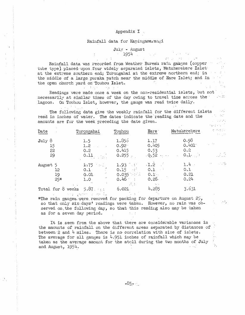
Appendix I
Rainfall data f u r I@nin&amarant;,i
July - August 19'54 . . . .
, . .. . : . I:
Rainfal l data was recorded from Weatiner Bureau ra in gaup;es (copper . . tube type) placed..upon f o u r widely separated i s l e t s , Matukereliere I s l e t
. . a,t the extre~.e southern end; Toro~gahai a t the extreme noythern end; ill . .
the middle of a l a ~ g e . p u ~ , a k a patch near the middLe of Hare I s l e t ; and i n . '
tine open ch~trch yard on Touhou I s l e t . . . . .
. . . , . , . Readings were made once a week on the iloil-residei?tial i s l e t s , b u t not '
~
.. ... necessarily a t s imilar times of the day owing t o t rave l time acyoss the - , -
Lagoon. O n Touhou I s l e t , however, t he gauge 17as read twice dai ly . . ,
. . . .
The folloving data give the weekly r a i n f a l l fo r the d i f f e r en t i s l e t s . . . . .
read i n inches of water. The d a t e s i n d i c a t e the reading date a n d the amownts a r e f o r tine wee^ preceding the d.ate given. . . , .
, . : . .
Date - Torongahai Touhou -- Hare -- Matu~<erel.ere ---- -
. . . j . j .: 1 . 4 August 5 1.75 . . : 1.93 ' . . .. 12 0 .1 0.15 .:: 0.1 . 0 .1 19 0.01 0 . 0 3 5 . : . - 0 . x . . 0.21 25* 1 .0 " 0 . 4 6 . : 0.26. 0.24
,. . .. . . . . . . Total for 8 weeks 25.87. . : : 6.021 4.205 3.631
, . . , . . . . . , . < . . , . ... . ~
*The ra in gauges,;w$re.i-emoved f o r packing f o r departure on August 225, so t h a t only s ix :days l readings vere %alren. However, no ra in vas ob- . . .. served on , the following day, so t h a t *his readii-ig a l so may be bake11 a s f o r a seven day period. . .
It is seen f romthe above t h a t there a r e considerable variances i n the amounts of r a i n f a l l on the d i f fe ren t areas separa-ted by distances of .'
between2 and 4 miles. There is no correla t ion with s i ze of i s l e t s . The aveyage f o r a l l gauges i s 4.951 inches of r a i n f a l l which may be taken as the average amouii-i f o r the a t o l l during the two months of July
. . and August, 1954. . ,

Appendix I1
Meteorological data Tor Kapingamarangi
Prior t o -the a r r i v a l of the geographer who was responsible for tile meteorological recordings a f t e r h i s a r r iva l on July 3, other expedition members who had arrived e a r l i e r had s e t up the r a in gauges on four dif- fe ren t i s l e t s and attached a Taylor maximum-minimum thermometer t o the shaded doorway of the thatched house used a s a laboratory by the expedi- t ion. This was f ixed approximately a meter from the grourd. Maximum and minimum readings on June 25 were fo r the preceding 18 hours, there- a f t e r for the preceding 24 hours. Taylor instrumentreadings were made by Niering from June 25 t o July 10, accompanied by notes on r a i n f a l l oc- currence.
Beginning with July 6, recordings were made on the Weather Bureau 10-day form. The maximum-minimum readings were made with s - ta~dard Weather Bureau thermometers. However, on July 9 the maximum thermometer broke. Subsequent temperature recordings again were made by the Taylor instrument. On July 21, the Taylor instrument and the hygrothermograph were moved t o a shelf under a t i n roof of an open shack nearby where they were shaded and open t o t h e breeze.
The following recordings and notes were made by Niering:
Date - Max. Temp. Min. Temp. Time - Remair1r.s
June 25 87.5' F. 79.0' F. 7:50 a.m. l i g h t breeze 26 90.5 79.5 8:OO ,, I ,
27 93.0 81.0 1O:bj f I,
28 9 1 ~ 0 81.0 a:oo I f
29 92.0 78.0 8:30 I, , shover,
July 1 93.0 2 92.0 3 91.0 4 92.0 5 91.0 6 89.0 7 88.0 8 91.0 9 89.0
10 91.0
6:30 p.m. 8: 30 l i g h t breeze, intermit-
t e n t r a in p.m., evening 8:OO l i g h t shower 3 p.m. ~ : O O l i g h t shower 4 p.m. 8:15 8:45
heavy showers 8 p.m.
8:OO heavy showers p.m., night 8:15

WDS 1009-E Appendix 11, p. 1
-- Location: U. S. DEPARTMENT OF COMMERCE
WEATHER BUREAU 1C-Day Fire-Weather Record
Time ................ a.m. Time .... ~ .... m.
-- :I
The f i v e s o r Letters .aed for cloud data are &om the Cloud Cod6 Chart of the Weather Bweau. The r a i n of 0.25 inches at 10 p.m, on July 5 was par t of t he shower t h a t occurred i n late afternoon.
Under Vis ib i l i ty : E meax Excellent; C- - ~ ~ o d ; F - Fair; P - Poor.
July 9 - The madmum thermometer used up t o t h i s da te was broken during t h i s evening. Thereafter meximum and minimum readings were taken wi th a Teylor Maximum-Minimum Thermometer.


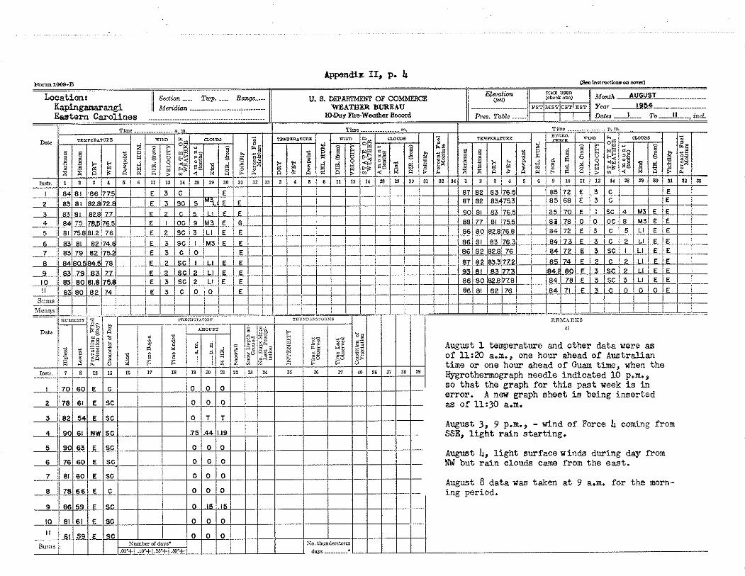
Appendix 11, p. & Form 1009-2
bi
August 1 temperature and other da ta arere as of U:20 a.m., one hour ahead of Australian time o r one hour ahead of Guam time, when the &-grothernograph needle indica ted 10 p,m., s o t h a t the graph f o r t h i s pas t week i s i n e r ror . A new graph shee t i s being in se r t ed as of 11:30 a.m.
August 3, 9 p.m., - wind of Force & coming from SSE, l i g h t r a i n s t a r t i ng .
August &, l i g h t surface winds during day from NW but r a i n clouds came from t h e east.
August 8 da t a was taken at 9 a.m. f o r the morn-


Appendix 11, p. 6 Form 1003-E (Scp inalrvrlionsan Cnr"r1 ....... ,.. --
Location: i Section .... TzLp ..... Range .... ....................... ....................... Kapingamarangi Median 11
Eastern Carolines 1 1 0 . ~ ~ ~ Fire.Wertbei Record plea. Table ...... ... .... - .. ................................................. . .. .~ - ..--=---= =.==<. .:--: ...
31 1 Sums ji --

SOIECE MATERIALS USED
1. Buck, Peter, The material cu1.ture of Kapingmaran(:i, B i s h o ~ Museum Bulle t in 200, Ilocolulu, 1950.
2. Ei le rs , Anneliese, Insela um Pona~e, Erheb:riisse der siidsee Ex.pedition 1906-1910, Ha.mbizrg, 1934.
3 . Elbert , Samwl, Liuguis.tic stud5- of Knpingamarangi, Pacif ic Sc ieXe Board, Washingkx, D. C. , 191.;8.
4. Emory, Kenneth, The people 3f Kapingama::angi, ca:?bboa copy of awthor 's manv.scrip-l, Bishop Museum, 19514..
5 . Fosberg, F. H., Soils of the northern Marshall a-tolls, v i t h special reference ti, the Jemo ser ies , S o i l Science, Vol. ~(8, No. 2, Aug. 1954.
6. Gem~an:~, Reichs";g, Denksch::iftern I V , Das Schutzgebiet der Marshal-l Inseln 1893-94, Steuotirai>hische Bcrichte i k e r die Verhandlungen des Xeichs-tages I X Le$;slatur Perioc?e, III, 1.894-95, Beiml.in, 1895.
7. Kalaw, Maximo hl., The coconut i-adus-try, The Phili.ppiries NaLiona.1 As - sembly, Mani!.a, 191i0.
8. Miller, Ralph R . , Health report of Kapii~gamarann,i, Atoll Research Bulletin, Eo. 30, September 19 j 3.
9. Mu/iurphy, Iiayinond E. , Landovnership on a Micronesian a t o l l , Geographical Review, October 1948.
10. Nevland, H. Osman, The plawti?g, cul-tivation arid e,xpression of coco- nuts, kenleis, cacao, arid edible vegetable o i l s and seeik of commerce, LOXIOII, 1919.
11. Sanpson, H. C . , The coconu'c palm, the science and prac t ice of coconut cult iva-t icn, Lor.doi-, 2.9'23.
2 . S-tone, Ear l L., The s o i i s and agriculture of Arno A-toll, Xarshall. .Islands, Atoll Research Bul le t in , Nos. 5, 6, 7, Noven~ber 1951.
13. United States 3 u s t Terri tory, S - t a t i s t i ca l Requirements, Ponape Dis- t r i c t , F i sca l Year. 1954 (n~in!eogra~hed).
14 . United States Hydrogcaphic Office, Sai l ing Directions f o r the Pacific Islands, Volume I, Washington, D. C . , 1952.
15. United States Navy, Office of nJaval Operations, OPNAV 50E-5, C iv i l Affairs Handbook, East Caroline Islands, 1944.
16. United States Xavy, O N 1 Nunber U(152 - ve r t i ca l a e r i a l photos of Kapingmarangi l : 5 , O O O enlarged from 1:15,000.
17. United States Naval A i r Station, Guam, Photo Laboratory, W-5-7836- L-7-54, Aerial oblique photos of Kapingamarangi Atoll.


![[Osprey] [Warrior Nr. 037] German Seamen 1939-45](https://static.fdocuments.in/doc/165x107/577ccdbc1a28ab9e788c992c/osprey-warrior-nr-037-german-seamen-1939-45.jpg)