ASSOCIATION OF BRITISH COLUMBIA LAND SURVEYORS … · Zenith reading theodolite No watch error R.O...
17
ASSOCIATION OF BRITISH COLUMBIA LAND SURVEYORS EXAMINATION FOR ADMISSION AS A LAND SURVEYOR PRACTICAL SURVEYING – PART ONE – APRIL 2005 TIME: 3.0 HOURS 100 MARKS 1 The following UTM Sea Level Corners define a Mineral Cell CellKeyID093A12B061C ZONE(COR) EASTING NORTHING 10(SW) 592281.796 5823540.369 10(SE) 592705.524 5823548.412 10(NE) 592696.735 5824011.867 10(NW) 592273.048 5824003.824 a) The mean elevation of the ground is 1200 metres. Provide the UTM bearings and ground level distances of the cell’s 4 boundaries that will be posted on the ground. 6 b) What is the geodetic azimuth of the west boundary of the cell? 3 c) How is geodetic azimuth related to astronomic azimuth? 3 2 What is the approximate magnitude of the shift from NAD 27 to NAD 83 CSRS in British Columbia? 2 Photo Control 3 What are the advantages of measuring in a stereo model as opposed to ground survey techniques? 2 4 Calculate the following photo scales. Place your answers in the spaces provided. 4 Photo Distance Ground distance Photo scale 3 inches 1812 feet 10cm 2832m 152mm 800m 305mm 6985m Instrument Calibration 5 The Leica TC705 total station is a “5-second” instrument according to the manufacturer’s specification (based on ISO17123-3 standard). The distance accuracy is specified as 2mm ± 2 ppm (based on ISO17123-4 standard). The smallest display resolutions of the instrument are 1″ (for angle measurement) and 1 mm (for distance measurement). After properly adjusting and calibrating the instrument, you are to use it in a 2D network survey. Answer all of the following, clearly showing all of the steps of your calculations. 8 a) If one horizontal direction is measured in a single face (Face I or Face II) position of the telescope, what is the accuracy of the direction measurement? b) If a horizontal angle at a station is measured (using directional method) in Face I and Face II positions of the telescope, what is the expected accuracy of the mean angle measurement? c) What is the accuracy of a horizontal angle derived from two direction measurements (using only one face of the telescope)? d) Determine the number of times an angle must be measured (using directional method) in order to achieve a horizontal angular accuracy of 5″. Page 1 of 5
Transcript of ASSOCIATION OF BRITISH COLUMBIA LAND SURVEYORS … · Zenith reading theodolite No watch error R.O...

ASSOCIATION OF BRITISH COLUMBIA LAND SURVEYORS EXAMINATION FOR ADMISSION AS A LAND SURVEYOR
PRACTICAL SURVEYING – PART ONE – APRIL 2005 TIME: 3.0 HOURS 100 MARKS
1 The following UTM Sea Level Corners define a Mineral Cell
CellKeyID093A12B061C ZONE(COR) EASTING NORTHING 10(SW) 592281.796 5823540.369 10(SE) 592705.524 5823548.412 10(NE) 592696.735 5824011.867 10(NW) 592273.048 5824003.824
a) The mean elevation of the ground is 1200 metres. Provide the UTM bearings and ground level distances of the cell’s 4 boundaries that will be posted on the ground. 6
b) What is the geodetic azimuth of the west boundary of the cell? 3 c) How is geodetic azimuth related to astronomic azimuth? 3
2 What is the approximate magnitude of the shift from NAD 27 to NAD 83 CSRS in British Columbia? 2
Photo Control 3 What are the advantages of measuring in a stereo model as opposed to ground
survey techniques? 2
4 Calculate the following photo scales. Place your answers in the spaces provided. 4
Photo Distance Ground distance Photo scale 3 inches 1812 feet
10cm 2832m
152mm 800m
305mm 6985m
Instrument Calibration 5 The Leica TC705 total station is a “5-second” instrument according to the
manufacturer’s specification (based on ISO17123-3 standard). The distance accuracy is specified as 2mm ± 2 ppm (based on ISO17123-4 standard). The smallest display resolutions of the instrument are 1″ (for angle measurement) and 1 mm (for distance measurement). After properly adjusting and calibrating the instrument, you are to use it in a 2D network survey. Answer all of the following, clearly showing all of the steps of your calculations. 8 a) If one horizontal direction is measured in a single face (Face I or Face II)
position of the telescope, what is the accuracy of the direction measurement? b) If a horizontal angle at a station is measured (using directional method) in Face
I and Face II positions of the telescope, what is the expected accuracy of the mean angle measurement?
c) What is the accuracy of a horizontal angle derived from two direction measurements (using only one face of the telescope)?
d) Determine the number of times an angle must be measured (using directional method) in order to achieve a horizontal angular accuracy of 5″.
Page 1 of 5

ASSOCIATION OF BRITISH COLUMBIA LAND SURVEYORS EXAMINATION FOR ADMISSION AS A LAND SURVEYOR
PRACTICAL SURVEYING – PART ONE – APRIL 2005
Page 2 of 5
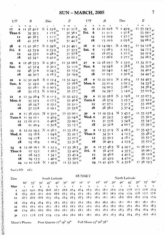
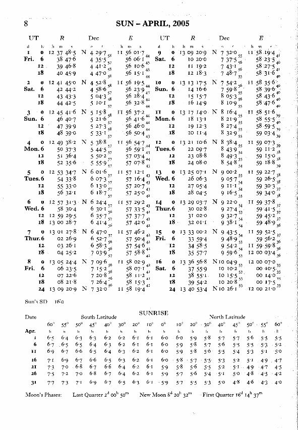
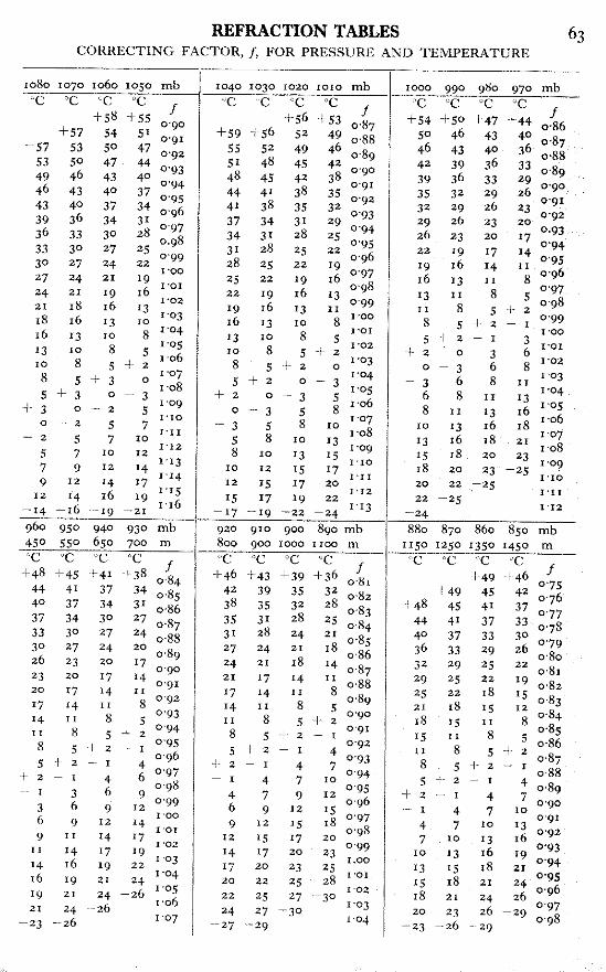
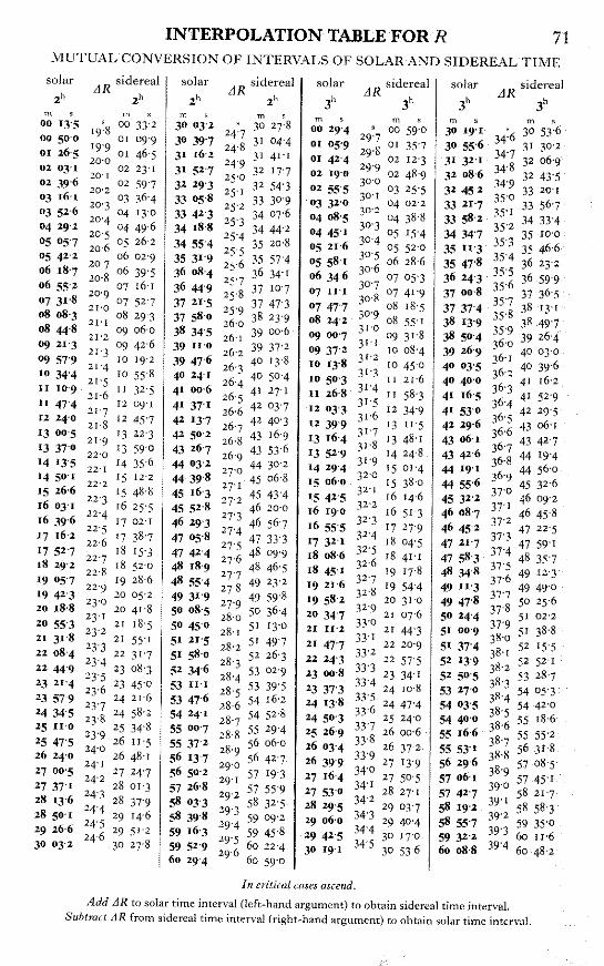
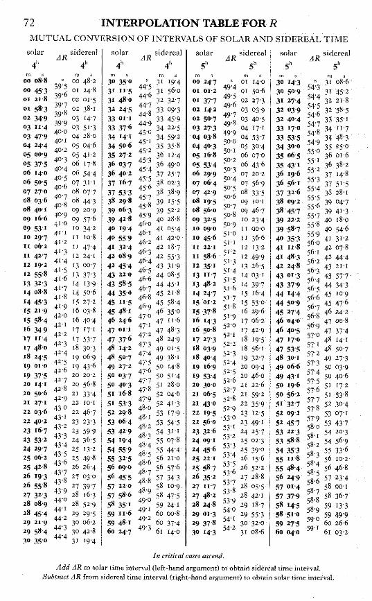
Sun Shot Calculation 6. Using the altitude azimuth method and the following solar observation data calculate
the azimuth from the instrument to the reference object. Show intermediate computational steps for a portion of the total mark. 10
Date: May 15, 2005 Pacific Daylight Savings Time
Latitude 49° 15’ 30” N. Temp. 10° C Pressure 1013 mb
Zenith reading theodolite No watch error
R.O. at 110° magnetic 20° east declination
UL – denotes Sun’s upper limb LL – denotes Sun’s lower limb
LE – denotes Sun’s leading edge TE – denotes Sun’s trailing edge
Station HCR VCR Local Time R.O. 0° 00’ 00” Face left Sun LL LE 120° 53’ 15” 50° 31’ 15” 16h 30m 00s
Face right Sun UL TE 300° 33’ 45” 309° 46’ 25” 16h 31m 30s
R.O. 180°00’ 40” Please Note – Appropriate pages from the Star Almanac will be provided by the invigilator.

ASSOCIATION OF BRITISH COLUMBIA LAND SURVEYORS EXAMINATION FOR ADMISSION AS A LAND SURVEYOR
PRACTICAL SURVEYING – PART ONE – APRIL 2005
Page 3 of 5
ASSOCIATION OF BRITISH COLUMBIA LAND SURVEYORS EXAMINATION FOR ADMISSION AS A LAND SURVEYOR
PRACTICAL SURVEYING – PART ONE – APRIL 2005
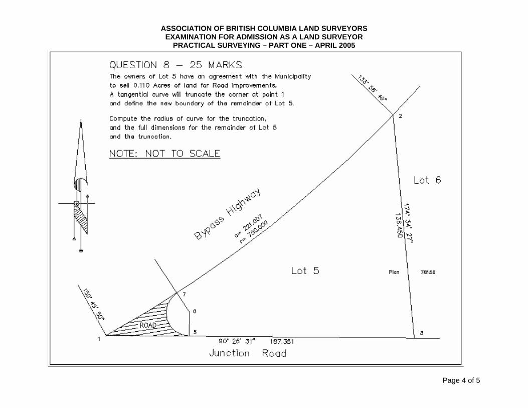
Page 4 of 5

ASSOCIATION OF BRITISH COLUMBIA LAND SURVEYORS EXAMINATION FOR ADMISSION AS A LAND SURVEYOR
PRACTICAL SURVEYING – PART ONE – APRIL 2005
GPS
9 GPS Basics: 3 a) What is the fundamental frequency of GPS? b) What are the L1 and L2 frequencies in MHz? c) What does GDOP stand for? d) What is the unit for GDOP value? e) What value is considered as a good GDOP and explain why? f) How many satellites are required to compute the GDOP value?
10 RINEX 2 a) What does RINEX stand for? b) How do you use RINEX files in the GPS industry?
11 RTCM 2 a) What does RTCM stand for? b) How do you use RTCM in the GPS industry?
12 Geoidal Model 2 a) What is a Geoidal Model? b) What is the name of the current Geoidal Model in BC and what are the relative and
absolute accuracies of this Geoidal Model?
13 Differential Techniques 3 a) Describe the basic principle of double differencing b) Define ‘Ambiguity’ in GPS c) What is the unit for ‘Ambiguity’ value?
14 Inter-mixing different GPS Antenna Types in Baseline processing 2 a) L1 and L2 phase centre offsets are usually measured with respect to what reference
surface? b) Why is it important to understand the concept of inter-mixing different GPS antenna
types in baseline processing?
15 Precise Ephemeris 3 a) Name two advantages of using Precise Ephemeris b) Name one source to obtain the Precise Ephemeris c) What is the name of the common format for Precise Ephemeris?
Page 5 of 5