Assessing the flood risk · The United Kingdom (Thames River) The United States (Mississippi River)...
44
Assessing the flood risk Katsuhito Miyake Seniior Researcher, ICHARM, Public Works Research Institute, Japan
Transcript of Assessing the flood risk · The United Kingdom (Thames River) The United States (Mississippi River)...

Assessing the flood risk
Katsuhito Miyake Seniior Researcher, ICHARM,
Public Works Research Institute, Japan

1. Are the existing policies and resulting infrastructures adequate within high-risk
flood regions?
Situation in Japan

Physical Protection level for flood disasters (before consideration of Climate Change)
1回/30~40年(大河川)1回/ 5~10年(中小河川)(当面の目標)
日本
フランス(セーヌ川)
アメリカ(ミシシッピー川)
イギリス(テムズ川)
オランダ(高潮計画)
1回/100年
1回/500年
1回/1000年
1回/10000年
達成率60%(2006年)
完成(1988年)
達成率89%(2002年)
完成(1983年)
完成(1985年)
1回/30~40年(大河川)1回/ 5~10年(中小河川)(当面の目標)
日本
フランス(セーヌ川)
アメリカ(ミシシッピー川)
イギリス(テムズ川)
オランダ(高潮計画)
1回/100年
1回/500年
1回/1000年
1回/10000年
達成率60%(2006年)
完成(1988年)
達成率89%(2002年)
完成(1983年)
完成(1985年)Netherland(high tide planning)
The United Kingdom
(Thames River)
The United States
(Mississippi River)
France(River Seine)
Japan
Completion (1985)
Completion (1983)
Achievement rate of 89% (2002)
Completion (1988)
Achievement rate of approx. 60% (2006)
1/100 years
1/50 years
1/1,000 years
1/10,000 years
1/30 to 1/40 years (major rivers)1/5 to 1/10 years (medium to minor rivers)
Compared with other industrialized nations, physical protection level against floods in Japan is much lower.

4
Increasing flood risk due to changes of social conditions 1
市営地下鉄
各年代間に整備された交通網
市営地下鉄
各年代間に整備された交通網
小田急小田原線 東急東横線
東海
道線
第一京浜
京浜
急行
線
南武線
横浜線第二京浜
小田急小田原線 東急東横線
東海
道線
第一京浜
京浜
急行
線
南武線
横浜線第二京浜
Progress of urbanization in flood prone area causes increase of flood risk and also causes new type of disasters, such as inundation of underground facilities.
Urbanization in Tsurumi River basin
2004
Urbanization rate:About 85%
Population:About 1.88million
1958
Urbanization rate:About10%
Population:About 450,000
Occurrence of widespread submergence at the underground facilities in urban areas
July 2004 in Fukuoka City
Oct. 2005 in Azabu-juban Sta., Tokyo Metro (Source :MLIT)
5
September, 2000
Heavy rain in Tokai region
%
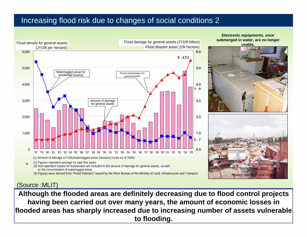
Increasing flood risk due to changes of social conditions 2
0
1,000
2,000
3,000
4,000
5,000
6,000
0.0
1.0
2.0
3.0
4.0
5.0
6.0
宅地等の浸水面積
一般資産被害額
一般資産水害密度
一般資産水害密度(万円/ha)一般資産被害額(千億円)
水害区域面積(万ha)
0.7
3 8
5,433
Flood density for general assets (JY10k per hectare)
Flood damage for general assets (JY100 billion)Flood disaster areas (10k hectare)
Waterlogged areas for residential housing
Amount of damage for general assets
Flood concentration for general assets
(1) Amount of damage (JY10k)/waterlogged areas (hectare) (costs as of 2000)(2) Figures represent average for past five years. (3) Non-operation losses for businesses are included in the amount of damage for general assets, as well
as the concentration of waterlogged areas.(4) Figures were derived from “Flood Statistics” issued by the River Bureau of the Ministry of Land, Infrastructure and Transport.
’78 ’79 ’80 ’81 ’82 ’83 ’84 ’85 ’86 ’87 ’88 ’89 ’90 ’91 ’92 ’93 ’94 ’95 ’96 ’97 ’98 ’99 ’00 ’01 ’02 ’03 ’04 ’05
Although the flooded areas are definitely decreasing due to flood control projects having been carried out over many years, the amount of economic losses in
flooded areas has sharply increased due to increasing number of assets vulnerable to flooding.
Electronic equipments, once submerged in water, are no longer
usable.
(Source :MLIT)

Increasing flood risk due to changes of social conditions 3
Due to the aging population, a significant number of victims were among those who required assistance in case of disasters, such as the elderly or children in day
care facilities.
被災者に占める高齢者の割合
65歳以上359人(63%)
65歳未満208人(37%)
65 years and over
359 persons63%
Under 65 years 208 persons
37%
Proportion of elderly among disaster victims
Asahi Shimbun on July 14, 2004
平成17年6月沖縄県佐敷町において、豪雨により老人福祉施設の背後斜面が崩壊し、入所者約70人全員が避難。
H17年 沖縄県佐敷町Sashiki Town in Okinawa Prefecture, 2005 The slope behind a nursing facility collapsed in SashikiTown, Okinawa Prefecture, in June 2005 due to the heavy rainfall, resulting in the evacuation of all 70 people in the facility.
77 children were trapped in school facilities by flooded water in Niigata.
(Source :MLIT)

In Japan, even under current situation, the level of protection against water-related disasters (flood, debris flow, tidal waves, etc.) is far from sufficient.

Today After sea level rise rate
Area(k㎡) 577 879 1.5Population(million)
40.4 59.3 1.5
Tokyo Bay(Yokohama City~Chiba
City)
Ise Bay(Kawagoe Town~Tokai
City)Osaka Bay
(Ashiya City~Osaka City)
176mil.(Today)
333mil.(After sea
level rise)
90mil.(Today)
126mil.(After sea
level rise)
138mil.(Today)
260mil.(After sea
level rise)
Expansion of areas below sea level when sea level rises 60cm
If sea level rise of 60 cm takes place,
If mean sea level rises 60cm due to global warming, area and population in the area below sea level increases 50% in 3 major bay areas.
(Source :MLIT)
Sea level: average highest water level on Full and Crescent moon days

100年後の計画の治水安全度 Design Flood Safety Level in 100 years
Design Flood Safety Level in 100 yearsPrecipitation amounts in 100 years after are likely to be about 1.1 to 1.3 times (1.5 times the maximum) of today’s amounts.
1/ 1001/ 150 1/ 2001/ 170
1/ 350 1/ 4301/ 3401/ 720 1/ 910
1/ 5601/ 1400 1/ 20001/ 1800
1/ 29001/ 8900
1
10
100
1000
10000
嘉瀬川Kase River
北上川Kitakami River
利根川Tone River
治水
安全
度(F
lood
Saf
ety
Leve
l)
現計画(Plan at present)1.1倍(1.1 t imes)1.2倍(1.2 t imes)1.3倍(1.3 t imes)1.5倍(1.5 t imes)
A very large flood safety level at present scale must be ensured in 100 years time if current flood safety level be unchanged.
The conventional flood control measures alone Cannot cope with the changes.
1/
1/
1/
1/

Increasing risk by Climate Change will pose serious threats in Japanwhat to do?

Because of a lot of uncertainties in current situation, We decided to follow 2 step approach
Procedure for deploying adaptation measures
【The first period : 5 years: until next IPCC Assessment report】To intensively investigate external force design and basic concepts on how to secure safety of basinTo selectively implement priority on-going programs related to adaptation measures. 【The second period】To reassess efforts taken in the first period and implement priority programs selected by the reassessment
To reflect adaptation policy and programs on master plans and river improvement action plans

Promotion of Flood Hazard Maps and regulatory measures
30分以内で床上浸水
60分以内で床上浸水
60分以上で床上浸水
最終的に浸水
破堤後に浸水するまでの時間Evacuation assembly
points available during waterlog
disasters are obvious at a glance.
Chikugo River
Example of Kurume City
Time it takes from breaching of levee to being waterlogged
Waterlogged above floor level within 60 minutes
Waterlogged above floor level within 30 minutes
Waterlogged above floor level in 60 minutes or more
Waterlogged eventually
土石流Mud and boulder slides
Hei
ght h
of l
and
on s
teep
slo
pe
s
Mountain streams presenting threat of mud and boulder slides
Precautio
nary
zone
Special
precautionary
zone Peak section
Land
with
grad
ient o
f two d
egree
s
がけ崩れLand slides
Top of land on steep slope
Hei
ghth
ofla
ndon
stee
psl
ope
Inclin
ation
of 30
degre
es or
mor
e
Specia
l prec
autio
nary
zone
Precau
tiona
ry zo
ne
Within two hours (50 m for all locationsexceeding 50 m)
Land on steep slopeBottom of land
on steep slope
Dangerous locations clarified through zone designations
・Restrictions to land use・Restrictions to structure of buildings・Recommendations for the relocation of existing
houses
Designation of hazardous areas for sediment-related
disasters
Publication of nationwide flood hazard maps
“Disaster Reduction” strategies by soft measures for minimizing the total damage(Source :MLIT)

Combination of Combination of various measures to various measures to minimize damage of minimize damage of
floodsfloods
二線堤(市道)
古川樋門
湛水区域
暫定堤防
肱川
矢落川
二線堤(市道)
古川樋門
湛水区域
暫定堤防
肱川
矢落川
Conventional flood protection to construct continuous levee from
downstream takes a long time for completion
Unconventional flood management measures
Introduction of disaster mitigation measures to minimize damage in addition to disaster prevention measures
To prevent spreading of flooded water by second line levee
Conventional flood protection by continuous levee
New concept of flood management measures
Conventional measures
Unconventional measures for various land use
Ring dike
Banking of residential area
Hiji-riverOhzu-city,Ehime-Pref.

1. Are the existing policies and resulting infrastructures adequate within high-risk
flood regions?
Situation in the “Asia”: most High-risk flood regions

Global Total Fatalities of All the Natural Disaster from 1986 to 2006
Europe7.5%
Africa 11.7%
Oceania0.3 %
Americas9.4%
Asia 71.1%
Oceania0.5%
Europe0.7%
Americas12.4%
Africa 2.7%
Asia 83.7%
Global Total Fatalities of Flood-related Disaster from 1986 to 2006
Flood-related disaster:Flood, SlidesWindstorm andWave/surge
Flood victims seek shelter as they wait for relief Pakistan July 2007 Source- Canadian Red Cross
Data source: EMDAT
Data source: EMDAT

Major Asian Cities Located in Deltas
High Vulnerability to Any Flood Regime Change from Land and/or Ocean
Major River Delta Systems in Asia
Green areas are land areas below 20 m elevation above mean sea level
(Source:ADB)

http://biz.nifty.ne.jp/nikkenkyo/4joho/738sokoniarukiki/jinkou.htm
http://www.stat.go.jp/data/kokusei/2000/topics/topics08 htm
Population Growth9 billion by 2050
(medium projection)
Asia
World
JapanWorld Population
Modified from Various sources

In Japan and in Asia, “The level of existing policies and resulting infrastructures within high-risk regions”is far from sufficient.
We should move forward towards putting water-related disaster risk reduction in higher national and international agenda.

Policy Avocation for mainstreaming water-related Disaster management
at Asia Pacific Water Summit (APWS)
3 to 4 Dec. 2007

1. Integrate water-related Disaster Risk Reduction (DRR) into national development plans, recognizing adaptation to increasing risks from climate change as a “highest” priority issue
2. Establish national and local goals/targets for water-related Disaster Risk Reduction, taking the impacts of climate change into consideration.
3. Recognize the importance of IWRM for water-related DRR and the need to strengthen comprehensive structural and non-structural measures
4. Develop preparedness indices for water-related DRR for the Asia-Pacific region
5. Develop water-related disaster warning systems and human capacities
Key Recommendations adopted for “Water-related Disaster Management” priority theme

2. What innovative approaches are available to assess risk within the context of complex interactions that arise from extreme events?

Risk?
(Risk Definition) The probability of harmful consequences, or expected losses
(deaths, injuries, property, livelihoods, economic activity disrupted or environment damaged) resulting from interactions between natural hazards and vulnerable conditions. (Source: UN/ISDR Terminology)
(Risk formulation)Risk can be interpreted in many ways e.g.
Risk= Hazard * Vulnerability Risk= Hazard * Vulnerability / Capacity Risk= Hazard * Exposure * Vulnerability
H V
C
R

Risk Formulation is so complex!
Climatic FactorClimatic FactorClimatic Factor
Geomorphological FactorGeomorphological FactorGeomorphological Factor
Human Intervention tothe Natural Environment
(Physical, socio-economic, etc)
Human Intervention toHuman Intervention tothe Natural Environmentthe Natural Environment
(Physical, socio(Physical, socio--economic, etc)economic, etc)
HydrologicalHydrological CycleCycle
Modified from Prof. Musiake slide
A number of items can be adopted for assessing “Hazard “, “Vulnerabilities”, “Capacities”, “Exposure” in quantitative and comparable form. Data acquisition is always the problem for developing countries
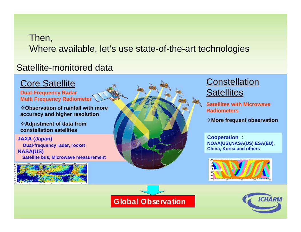
JAXA (Japan)Dual-frequency radar, rocket
NASA(US)Satellite bus, Microwave measurement
Core SatelliteCore SatelliteDualDual--Frequency RadarFrequency RadarMulti Frequency RadiometerMulti Frequency Radiometer
Observation of rainfall with more Observation of rainfall with more accuracy and higher resolutionaccuracy and higher resolution
Adjustment of data from Adjustment of data from constellation satellitesconstellation satellites
Constellation Constellation SatellitesSatellitesSatellites with Microwave Satellites with Microwave RadiometersRadiometers
More frequent observationMore frequent observation
Global Observation
Cooperation :NOAA(US),NASA(US),ESA(EU), China, Korea and others
Then, Where available, let’s use state-of-the-art technologies
Satellite-monitored data

FHMap: Size of paper
Inundation Map &
Vulnerability Map
Risk Map
Damaged (estimated) Map
Hazard Map
Synthesized and simplified Flood Risk Map
Flood plain zoning Map (administrative use)Flood plain zoning Map (administrative use)Flood insurance rate Map (administrative use)
Sca
le 1
/100
00-1
/150
00, W
hole
city
or
war
d w
ise
map
can
be
publ
ishe
d
Use of GIS
Where available, let’s use state-of-the-art technologies
Etc.

Risk CommunicationA number of Risk Assessment methodologies
could be invented. Effort should be made to identify the best (better) appropriate one to be used for specific objectives, target area, messages to be transferred, etc.
Risk Assessment is important, however ensuring appropriate Risk Communication could be as important as risk assessment.
Maps are normally used as most appropriate ways for risk communication.

Risk Assessment (Science, Academy, Government, etc. UN agencies, etc. )
International Society Government(national, local) Policymaker
Risk Communication High-level- for Policy formulation, planning, etc.
Local Communities,Local residents
Risk Communication Grassroots level - for risk awareness, emergency response, etc.
Risk Communication

Flood Mortality Risk
Total Economic Loss Risk by Flood
Population Density
Data source: The core data sets of Natural Disaster Hotspots - A Global Risk Analysis, Center for Hazards & Risk Research, Columbia University
Global Hotspots for
Floods

In developed countries, a number of flood risk maps have been publicized in various types
(past inundation, hazard, emergency response, etc.)

Without filling the stomach, no disaster coping capacity.
Asahi Shinbun,1999 目撃者 I
In many developing countries, Situation is totally different

A lot of people had been perished so that the land had been vacated.
Soon after, a lot of people have migratedinto the area.
People seem to be waiting to be killed.

Village B (Old One)
Village A (Developing One)
National Highway
Barrier cut off by local people in village B
Nepalgunj (Headquarter of Banke District)
Rapti
River
Trib
utar
y
Dyke cutting by local people

Do people feel always stress due to Flood
Risk Map?
Has it created conflicts? e.g. those who were
trusted earlier will be no more trusted
Unnecessary pressure to the administration such as
request to establish facilities, compensation to
relocate,……
Do land owners/ real-states lose their incomes or their business?
If there are not enough facilities such as routes and evacuation centers, can FRM still work?
Managers
There are many other (potential) obstacles that hinder Risk Communication, especially in developing countries
For many reasons, flood risk map publication in developing countries is still in very low-level.
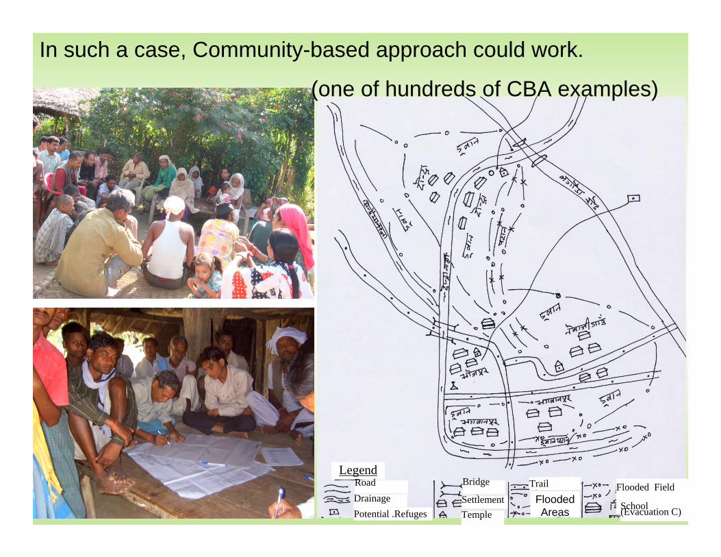
LegendRoadDrainagePotential .Refuges
Bridge
SettlementTemple
Trail Flooded Field
School (Evacuation C)Flooded Areas
In such a case, Community-based approach could work.
(one of hundreds of CBA examples)

Hazard Map Vulnerability Map
Maps drawn by community-people – beautiful maps! We can provide a little bit of scientific knowledge

3. Who bears ultimate responsibility for ensuring that the right measures are in place?
Balanced combination of three forms of flood management
PublicHelp
Mutual Help
Self Help
However, “Self help” should not to be used as excuse for non-action by Governments.
Ideally, national governments should take the overall responsibilities for planning, and coordination of the flood management measures.

Integrated Approach to Flood Management should be sought, thus making flood management everybody’s business
(Policy Brief Paper, Asia-Pacific Water Summit) It is important to look at whole water regime, which means both scarce and excessive water management must be done in concerted manner.IWRM is a broad concept promoting the integrated management of water in a sustainable manner and thus encompasses a wide variety of sectors such as physical, geographical, socio-economic, and cultural domains. The IWRM approach, therefore, must also be applied to water-related DRR.
Resources are always scarce
Some movements in this direction are ongoing such as APFM (driven by WMO)

Role of engineers/scientists?
EngineersIn the building
Risk Assessment
Flood Management Measures
etc.
Policymakers
Communities, local residents
Engineers in the field/community
With “Localism”Perspectives. Approach should be diverse.
Risk Communication

Thank you for your attention!
Last but not least, It’s good to be with family/friends.

Let’s try together to minimize the number of flood victims.
Thank you very much for your attention!
Destruction by Cyclone Sidr in Chailtatoli, Bangladesh on November 20th, 2007Source: AFP/Jewel SAMAD
Destruction by Cyclone Sidr in Chailtatoli, Bangladesh on November 20th, 2007Source: AFP/Jewel SAMAD

ICHARM


FHM training course
ICHARM/PWRI has been organizing FHM training course annually since 2004, usually accepting 16 trainees from 8 countries.

Development of Integrated Flood Analysis System (IFAS) Ver.1
A computer software package specifically for flood runoff analyses with GUI using ground-based and satellite-based rainfall data
Being developed by joint research (FY2005-2007) atICHARM/PWRI, Infrastructure Development Institute (IDI/IF-Net),
and nine major civil-engineering consulting companies
Global GIS dataGlobal GIS data
Satellite rainfallSatellite rainfall
Runoff analysisRunoff analysis