Assaulting the Paradise - Oilwatch · • Natural features consisting of physical and bio-logical...
133
Petroleum Companies in Protected Areas Assaulting the Paradise
Transcript of Assaulting the Paradise - Oilwatch · • Natural features consisting of physical and bio-logical...

Petroleum Companies in Protected Areas
Assaulting the Paradise

Assaulting the Paradise: Petroleum Companies in Protected Areas
2005

Author: Oilwatch
Edition: Elizabeth Bravo
Ivonne Yánez
Translation: Susan Bertie
Anne Marie-Brougere
Photographs: Iñigo Azcona
Graphic Design and Diagramation:
MANTHRA EDITORES - 2555 056
With the support of:
S I E M E N P U
MORATORIUM TO EXPLORATION AND EXPLOTATION OF HYDROCARBON IN NATURAL PROTECTED AREAS ARGUMENTS FROM THE INTERNATIONAL LEGISLATION 5
OIL EXPLOITATION IN THE YASUNI BIOSPHERE RESERVE 34
OIL EXPLOITATION IN BANC D’ ARGUIN NATIONAL PARK IN MAURITANIA 76
OIL EXPLOITATION IN LORENTZ NATIONAL PARK - INDONESIA 110
Table of contents

�

�
Preceding note
Based on international law, this document will try
to validate the legitimacy of a moratorium to the
exploration and exploitation of hydrocarbons in
natural protected areas.
The analysis has been centered on the Conventions
and Organizations with the largest number of mem-
bers and the most extensive areas of interest. This
selection is mainly due to Oilwatch’s vast geographi-
cal presence. But, foremost, the decision was made
because these Organizations and Conventions,
closely linked to the accepted international order, set
the guidelines in environmental matters.�
We may not necessarily agree with the way in which
these agents are operating, whose consequences
have been repeatedly condemned by Oilwatch. This
is precisely why my greatest fear in doing this job was
to discover that the institutions being analyzed were
not providing legal arguments to justify the morato-
rium on the exploitation of hydrocarbons.
Surprisingly, as my analysis advanced, I became
more convinced of the contrary, discovering an
endless number of conceptual tools and even
concrete declarations that can be used to le-
gitimize the moratorium. So, as an illumination,
it came to me the idea that the inefficacy of the
norms studied did not arise due their own con-
tent, but rather from the fact that the agents who
most contributed to the degradation of the envi-
ronment and biological diversity were monopoliz-
ing their interpretation and application, eliminat-
ing their probable protective effects.
Therefore, those of us who are committed to the
protection of the environment and biological diver-
sity must take on the task of actively contributing
to the process of interpreting and applying the
available legal instruments, thus rescuing all the
positive aspects they may contain. This does not
mean abdicating our principles but rather taking
advantage of the opportunities they give us, sifting
through the gaps of power.
MORATORIUM TO EXPLORATION AND EXPLOTATION OF HYDROCARBON IN NATURAL
PROTECTED AREAS
ARGUMENTS FROM THE INTERNATIONAL LEGISLATION
María del Mar Pérez
1. On Regional Agreements associated with environmental matthers, check the following United Nations pages:http://www.unep.org/dpdl/Law/Links/index.asp#treaty http://www.unep.org/dpdl/Law/Law_instruments/law_instruments_regional.asp

�
For example, even though the
economic valuation of the eco-
systems may seem an aberration,
we have to admit that the dominant
ideology with which everything is mea-
sured by money, and it is the sole admissible
criterion for comparison. Following this train
thought, only by demonstrating that the price
of an ecosystem is superior to the benefit of
oil exploitation, will we be able to transmit the
message of the importance of the conservation
of the environment. Recent trends to commer-
cialize environmental services, promoted by the
contaminating agents, are a perversion of this
system, yet not a necessary consequence.
The arguments in favor of the moratorium that we
have been analyzing, arise essentially from the
incompatibility between the exploration and ex-
ploitation of hydrocarbons within natural protected
areas (NPAs) and the concept of sustainable de-
velopment. This incompatibility is noticed in three
different aspects:
• Hydrocarbon exploration and exploitation
activities have ominous consequences over
the conservation of the biodiversity, which
constitutes one of the fundamental reasons
for the creation of PAs.
• The oil industry is one of the main causes for
our climate change. This process is accentuat-
ed when said activity results in the deterioration
of important carbon sinks, such as the NPAs.
In addition, the climate change process repre-
sents a severe threat to biodiversity.
• The oil industry that works in NPAs does not con-
tribute, in net terms, to the development; rather, it
reduces the ecosystems’ abilities to development
functions with incalculable value for the human
being (including social and cultural aspects).
The rights of the indigenous populations are closely
related to the purpose of this research, and are
contemplated in most of the international disposi-
tions examined. However, I have chosen not to
deal with this subject because, due to its complexity
and the differentiated approach with which it should
be handled, a new in-depth study should be car-
ried out. Although I personally believe that the set-
ting up of an oil company in indigenous lands is
a serious threat for their cultural and even physical
integrity, I do not believe that the rights of the indig-
enous population should be one more argument to
achieve the moratorium, for two reasons:
• The ancestral lands of the indigenous popula-
tions are not circumscribed to the PAs.

�
• If we lobby to ban a priori oil activities from these
territories, we are incurring into a paternalistic
behavior —well meaning, but paternalistic none
the less— which the indigenous populations
have been trying to escape for many centuries.
I. THE WORLD HERITAGE CONVENTION
This Convention Concern’s with the Protection of
the World Cultural and Natural Heritage2, hereinafter
WHC, took place in �972 within the UNESCO, as a
response to the escalating threats, both in magnitude
and severity, against this heritage.
Article 2 of the WHC defines what should be un-
derstood as natural heritage, stating that for the
effects of the Convention, the following should be
considered as such:
• Natural features consisting of physical and bio-
logical formations or groups of such formations
that have an outstanding universal value, from
an aesthetic or scientific point of view;
• Geological and physiographical formations and
precisely delineated areas that constitute the
habitat of threatened species of animals and
plants, with an outstanding universal value, from
the point of view of science or conservation;
• Natural sites or precisely delineated natural areas,
with an outstanding universal value from the point
of view of science, conservation or natural beauty.
The text of the Convention outlines three different
levels of protection for natural heritage:�
a. National level: According to Article 4, the duty
of protecting the natural heritage belongs pri-
marily to the State where it is located. This obli-
gation is clearly explained in Article 5, including,
among others, the following duties:
• To adopt a general policy which aims to give
the cultural and natural heritage a function in
the life of the community and to integrate the
protection of that heritage into comprehen-
sive planning programs;
• To set up within its territories, services for the
protection, conservation and presentation of
its heritage;
• To develop scientific and technical studies and re-
search and to work out such operating methods
that will make the State capable of counteracting
the dangers that threaten its natural heritage;
• To take the appropriate legal, scientific, tech-
nical, administrative and financial measures
necessary for the identification, protection,
2. http://whc.unesco.org/archive/convention-es.pdf .3. The Convention is subject to the same limitations as most of the international agreements: the impossibility to enforce in a coactive manner
the compliance of the obligations. However, there are indirect mechanisms that facilitate the compliance of obligations assumed by States Parties to the Convention, such as the withdrawal of financial support or the formulation of recommendations.

�
conservation, presentation and
rehabilitation of this heritage.
b. Transnational Level:
Each State Party to the Con-
vention undertakes not to take
any deliberate measures which might
damage directly or indirectly the natural heritage
situated on the territory of other States Parties to
the Convention (Article 6.�).
c) International Level: In general terms, this level
is regulated by Article 6.2, which allows States
Parties to seek international support to comply
with the provisions of Article 5.
In order to obtain protection status, a natural area
must be included in the so called “World Heritage
List”. The inclusion in this List is decided by the
World Heritage Commission, once the following
criteria are met:4
�. Outstanding universal value.
2. Integrity.
�. National protection and management programs
that will ensure that the conditions under � & 2
are maintained.
4. Reasonable balance between natural and cul-
tural heritage included in the List.
5. Representative heritage. Preference is given
to the inscription in the List of Natural Heritage
of those categories scarcely represented or
situated in countries whose natural heritage is
scarcely represented List.
6. Consent of the State in whose territory is located
the natural area.
Having made a general revision of the WHC, we will
now analyze the specific content of the protection ob-
ligations therein established, to determine up to what
point the compliance with such protection obligations
is compatible with the exploitation of hydrocarbons
within PAs included in the Natural Heritage List.
1. Transnational Protection and Climate Change
As stated before,5 the States Parties to the Con-
vention may not take any deliberate measures that
might damage directly or indirectly the natural heri-
tage on the territory of other States Parties to the
Convention (Article 6.� of WHC).
If we analyze the periodic reports – that for the
WHC are the tools to evaluate the conservation
4. Criteria for the inscription in the List and its procedures are found in World Heritage, 2005, Operational Guidelines for the Implementation of the World Heritage Convention, available in: http://whc.unesco.org/archive/opguide05-en.pdf hereinafter the Operative Guidelines. Note that the ecological valuation is not sufficient for the inscription in the List; criteria � through 6 have a political content.5. Article 6.�.

�
status of the natural heritage6 - we can conclude
that the reference to climate changes causing the
deterioration of this heritage is very than frequent.
For example, the increase in the sea-surface tem-
perature is considered to be the cause of coral
bleaching that is threatening the Great Barrier Reef,
in Australia, the largest and most diverse system
of coral reefs in the world7. The same happens in
all the Tropical area of the Pacific Ocean.�
In order to install a hydrocarbons plant, it would
be necessary to log two hectares of trees,9 which
in itself already represents a contribution to the
process of climate change. If we add the effect
of the hydrocarbon exploitation process, we can
conclude that when one State Party authorizes the
extraction of hydrocarbons inside a natural pro-
tected area —not yet included in the List— it is
undertaking an action that damages the natural
heritage situated in other States Parties to the Con-
vention and is therefore breaching the prohibition
stipulated under Article 6.� of the WHC.
2. Natural heritage in danger
When the actions taken to protect any natural heri-
tage are insufficient to the point that they threaten its
survival, Article 4 of the WHC foresees its inclusion in
the so-called “List of World Heritage in Danger”.
Among the many reasons that support the inclusion in
the List of World Heritage in Danger, Article 4 states:
• Big development projects.
• Destruction caused by modifications of the legal
protective status or resettlement in the property.
It is undeniable that these activities, which accord-
ing to WHC endanger natural heritage, are ever
present wherever there is exploitation of hydrocar-
bons. Therefore, when a State Party allows the ex-
ploration of hydrocarbons inside a declared world
heritage area, it is not complying with the obliga-
tions to safeguard this heritage, as stipulated un-
der Article 5 of the WHC.
The Operational Guidelines describe in greater
detail the types of dangers that are acceptable
to consider that a natural heritage is at risk.�0 In
this case, we also find undisputable ties with the
exploitation of hydrocarbons. Some reasons that
justify the inscription on the List of World Heritage
in Danger are:
6. Operational Guidelines, VA20�.7. See World Heritage, 2002, Monitoring World Heritage, p. �0. In: http://whc.unesco.org/documents/publi_wh_papers_�0_en.pdf8. “The main threats to biodiversity in the region are common to island ecosystems noted for their fragility and susceptibility to degradation. These threats include (...) climate change”. World Heritage, 2002, Proceedings of the World Heritage Marine Biodiversity Workshop, p. �2, in: http://whc.unesco.org/documents/publi_wh_papers_04_en.pdf. 9. Kimerling, J. �99�. Crudo Amazónico.10. See the Operational Guidelines, IV, B, for the reasons that justify the inclusion into the List of World Heritage in Danger.

10
• Severe deterioration
of the natural beauty or
the scientific value of the
property, as a conse-
quence of industrial de-
velopment, mining, pol-
lution, logging, firewood
collection, or major public works.��
• Human encroachment on boundaries or in
upstream areas which threaten the integrity of
the property.
• Planned development projects, within or adja-
cent to the property that the impacts imply a
threat of deterioration of the property’s inherent
characteristics.�2
3. Sustainable use of the natural heritage
Another criterion that, according to the Operational
Guidelines, justifies the inscription on the List of
World Heritage in Danger is the lack of an appro-
priate plan or management system. In order to be
appropriate, a management system should ensure
that the outstanding universal value and the condi-
tions of integrity at the time of inscription are main-
tained or enhanced in the future.�� This means that
an appropriate management plan must include
the concept of “sustainable use”, and must as-
sume that in certain situations, “human use would
not be appropriate”. The concept of sustainable
use defined in the Operational Guidelines implies
that the uses of the property should be ecologi-
cally and culturally sustainable, while maintaining
the conditions of outstanding universal value and
integrity of the natural heritage.
We should ask ourselves, then, about the defini-
tion of the term “sustainable use” in the imple-
mentation of the Convention, and about the com-
patibility between this use and the exploitation of
hydrocarbons in a natural heritage. In this sense,
as pointed out by Mercedes Podestá, “It is impor-
tant to consider that World Heritage is primarily a
matter of conservation and all proposals (of use)
must be subject to tests of appropriateness and
sustainability. The fact that a project could bring
economic benefits to local communities is not suf-
ficient reason to support it”.�4
From the decisions issued by the World Heritage
Commission we can infer a consolidated delinea-
tion that determines the incompatibility between
the “sustainable use” of natural heritage and ex-
tractive activities in general and the exploitation of
11. If we take into consideration the fact that most countries have a royalty system – that is, hydrocarbons are property of the State and they grant concessions to private companies for its exploitation – then the exploitation of hydrocarbons can be considered as a major public work.12. Note that they mention the word “deterioration” and not disappearance.13. See Operational Guidelines II.F, for the requirements that should be met for an appropriate management plan.14. UNESCO World Heritage Centre, 2004. Linking Universal and Local Value: Managing a Sustainable Future for World Heritage, p. �62, in http://whc.unesco.org/documents/publi_wh_papers_��_en.pdf

11
hydrocarbons in particular. Without trying to be ex-
haustive, it is important to mention, as an example,
the following decisions:
• 2�COM �5B.��:�5 Oil exploration is a threat to
the conservation of the Tubbataha Reef Marine
Park in the Philippines.
• 2�COM �5B.22:�6 Requests the Government of
the Russian Federation to eliminate the threat to
the integrity of Lake Baikal by the construction
of a gas pipeline.
• 2�COM �5B.26:�7 Congratulates the Republic
of Italy for ceasing extraction activities in the
Isole Eolie (Aeolian Islands).
• 2�COM �5B.�5:�� Welcomes the news that
mining company Energy Resources of Austra-
lia has made a commitment that no mining will
take place at Kakadu National Park without the
agreement of the aborigine population (Mirrar).
Expresses its concern over contaminated water
problems caused by the mining industry.
• 2�COM �5B.96:�9 Congratulates the Slovakian Gov-
ernment for halting mining activities in Spisský Hrad.
One definite proof that there is an intrinsic incom-
patibility between the protection of world heritage
and extraction activities is the adoption of the “Po-
sition Statement on Mining and Protected Areas”20
(August ��, 200�) by ICMM2�, after a series of ne-
gotiations with the IUCN.22
By making this Position Statement, fifteen lead-
ing mining and metal producing companies of
the world have made the pledge not to explore
or mine in World Heritage sites. This declaration
of moratorium is based on the mining companies’
recognition that “in some cases, exploration and
mining development may be incompatible with the
objectives for which areas are designated for pro-
tection, even after all technically and economically
feasible steps to reduce adverse impacts have
been considered”.
Likewise, Shell pledged in August 200� not to be-
gin new exploration and extraction activities in the
natural areas included in the World Heritage List,
stating that “there may be some areas which are
too sensitive for any operations”.2�
15. http://whc.unesco.org/en/decisions/&id_decision=�90 16. http://whc.unesco.org/en/decisions/&id_decision=�94 17. http://whc.unesco.org/en/decisions/&id_decision=�9� 18. http://whc.unesco.org/en/decisions/&id_decision=207 19. http://whc.unesco.org/en/decisions/&id_decision=26� 20. See ICMM, 200�, ICMM Newsletter, Vol. 2, No. 4, in 21. International Council of Mining and Metals. http://www.icmm.com/newsletter/ �60ICMMNewsletter- Vol2No4-Sept0�.pdf22. The IUCN (the World Conservation Union) is the advisory body that provides technical advice to the World Heritage Commission on matters related to natural heritage (see Operational Guidelines I.G).23. IUCN, 200�. Working Together for biodiversity: Speech by Sir Philip Watts, Chairman of the Committee of Managing Directors, Royal Dutch/Shell Group, in: http://www.shell.com/static/ media-en/downloads/speeches/ pbw_bio_270�200�.pdf

12
The moratorium declared by the mining compa-
nies shows an important advance in the protec-
tion of the environment, even if it is only applied to
areas included in the List. The application exclu-
sively to the areas in the List is supported, accord-
ing to the companies, by the fact that the criteria
established for the inclusion into the List are the
most rigorous and scientific that can be applied
for the delimitation of natural protected areas.24
But the most important achievement is the
fact that the mining companies themselves
have admitted that, despite the use of the best
available technology, extraction activities have
negative effects on the conservation of natural
areas, and therefore are incompatible with their
sustainable use.
II. UNESCO AND THE BIOSPHERE RESERVES
The concept of Biosphere Reserves (BR) was first
introduced in �972 by UNESCO’s Program “Man
and the Biosphere” – hereinafter MAB.
Biosphere reserves must meet certain criteria and
fulfill three additional functions:25
• Conservation function: To preserve genetic re-
sources, species, ecosystems and landscapes.
The exploration and mining of hydrocarbons is
a clear attempt against this function due to its
ominous consequences on biological diversity.
• Sustainable development: The hydrocarbons in-
dustry is, by antonomasia, unsustainable; thus its
presence in a BR attempts against this function.
• Logistic function: To support research and edu-
cation related to issues of conservation of bio-
diversity and sustainable development.
Physically, each biosphere reserve should contain
three elements:26
• Core Zones: Which are securely protected sites
for conserving biological diversity, monitoring
minimally disturbed ecosystems, and under-
taking non-destructive research and other low-
impact uses (such as education).
For practical purposes, and given that the Core
Zone is the only area that requires legal consti-
tution, its coverage normally coincides with the
extension of allready existing natural protected
sites. Exploration and exploitation of hydrocar-
bons in this Core Zone is totally excluded.
24. Do the political weight of the United Nations and the incorporation of political provisions for the inclusion on the List have anything to do with this? (See page 6).25. See UNESCO, �996, Biosphere Reserves: The Seville Strategy and the Statutory Framework of the World Network, p. 6 and Article 4.5 of the Statutory Framework, in: http://unesdoc.unesco.org/images/00�0/00�0��/�0��49e.pdf 26. See document in footnote 25 above, p. 4 and Article � of the Statutory Framework.

13
• Buffer Zones: Used for activities compatible with
sound ecological practices, including environ-
mental education, research, and ecotourism.
The concept and consequences of the activ-
ity of the hydrocarbon industry are radically op-
posed to the uses aforementioned.
• Transition Zones: Which may contain a variety of
agricultural activities, settlements and other ac-
tivities where the agents involved manage and
sustainably develop the area’s resources.
In rigor, the exploration and mining of hydrocar-
bons should be excluded from this area due to
its unsustainable character.
The following concrete arguments favor a morato-
rium in BRs:
a. Synergies with the Convention of Biological
Diversity (CBD).
Taking into consideration that all States with BRs
are parties to the CBD, one of the goals of the
Seville Strategy is to promote BRs as means to
implement the goals of the CBD.27 And, since the
CBD is opposed to the exploration and exploita-
tion of hydrocarbons within PAs2�, these activities
cannot be developed in BRs either. MAB’s29 of-
ficial documents and reports repeatedly make
reference to the ecosystem approach. Goal I of
the Seville Strategy also refers to the Conventions
against Desertification and Climate Change, with
analogue consequences.�0
b. Quality Economies
The economic activities to be undertaken in the
BRs must comply with the concept of quality econ-
omy, which means “activities, goods and services
that are produced and consumed in ways that are
compatible with and supportive of the objectives
set forth in the Seville Strategy and the articles in
the Statutory Framework of the World Network of
Biosphere Reserves”.��
27. See document in footnote 25, The Seville Strategy: Goal I, Objective I.�, Recommendation �, and implementation indicator I.�.�; Statutory Framework, Article 2.2.28. See page �7 and subsequent29. For example, see UNESCO, 2004, SC-04/CONF.204/14, in: http://unesdoc.unesco.org/images/00��/00�72/��7294e.pdf UNESCO, 200�, SC-03/CONF.217/14, in: http://unesdoc.unesco.org/images/00��/00��47/��4729e.pdf UNESCO, 2000, Seville +5 International Meeting of Experts (Proceedings), in: http://unesdoc.unesco.org/images/00�2/00�2�6/�2�605m.pdf UNESCO, 2000, Solving the Puzzle: The Ecosystem Approach and Biosphere Reserves, in: http://unesdoc.unesco.org/images/00��/00��97/��9790eb.pdf30. See pages 22 and 2�.31. See http://www.unesco.org/mab/qualityEconomies/Background.doc

1�
To achieve the status of quality economy, an activ-
ity should:�2
• Be consistent with the ecosystem approach
adopted under the CBD;
• Be based on the sustainable use of regional
natural and human resources;
• Promote a long-term perspective and strive for
economic stability based on efficiency, diversity
and equity;
• Be “soft” to nature and people, and respect tra-
ditional knowledge and cultures;
• Add value to local people and communities;
• Seek to promote income and employment op-
portunities and the balance between consump-
tion and production.
It is obvious that the oil industry does not satisfy
any of the above mentioned requirements.
c. IUCN Categories
Another argument that supports the thesis of in-
compatibility between the industry of hydrocar-
bons and BR systems is the application of the
protected areas management categories, estab-
lished by IUCN, to Biosphere Reserves. Following
is the application system:��
32. See UNESCO, 2004, SC-04/CONF.204/INF.7, in: http://unesdoc.unesco.org/images/00��/00��64/��64�6e.pdf 33. See Bridgewater, P., Phillips, A., Green, M., and Amos, B. �996. Biosphere Reserves and the IUCN System of Protected Area Manage-ment Categories. Although IUCN categories are not referred to in MAB’s official documents, the aforementioned publication was sponsored by MAB. This homologation already enjoys a consolidated extra official recognition, as demonstrated by Jane Robertson’s presentation, in MMSD, 200�, Report of the First Workshop of Mining and Biodiversity, p. 27, available in: www.iied.org/mmsd/mmsd_pdfs/biodiversity_min-utes_��_�2 _june_200�.pdf During this forum, Robertson pointed out that “the core area of the BR can be compared to IUCN’s Category I-IV and the buffer zone area can be compared with Category V-VI. All sectors must strictly respect the Core Area, but some activity is allowed in the buffer zone”.
IUCN Management
Category
Corezone
Bufferzone
Transitionzone
Ia Yes No No
Ib Yes No No
II Yes No No
III Yes No No
IV Yes Yes No
V No Yes Maybe
VI Maybe Yes Maybe
Key:Yes: compatibility between management objectivesNo: incompatibility between management objectivesQuizás: possible compatibility between managment objectives

1�
III. RAMSAR CONVENTION ON WETLANDS
The “Convention on Wetlands of International Im-
portance especially as Waterfowl Habitat”,�4 com-
monly known as the “Ramsar Convention”, was
signed in Ramsar, Iran in �97�, and came into
force in �975.
The Ramsar Convention (RCW) was adopted with
the purpose of protecting wetlands, which are de-
fined in Article � as “areas of marsh, fen, peatland or
water, whether natural or artificial, permanent or tem-
porary, with water that is static or flowing, fresh, brack-
ish or salt, including areas of marine water the depth
of which at low tide does not exceed six meters”.
The Convention also protects waterfowl, defined as
“birds ecologically dependent on wetlands”.
Although the RCW foresees the creation of a “List
of Wetlands of International Importance”,�5 the
Contracting Parties accept their obligation to pro-
tect all wetlands –whether they are included in the
List or not– situated within their territorial boundar-
ies. The obligations described below are directly
related to the subject under analysis in this report:
• The Contracting Parties shall formulate and im-
plement their planning so as to promote (…) as
far as possible the wise use of wetlands in their
territory (Article �.�).
• Each Contracting Party shall promote the con-
servation of wetlands and waterfowl by estab-
lishing nature reserves on wetlands, whether
they are included in the List or not, and provide
adequately for their wardening (Article 4.�).
• The Contracting Parties endeavor through man-
agement to increase waterfowl populations on
appropriate wetlands (Article 4.4).
After this general review of the RCW, we will now
proceed to examine its relationship with the exploi-
tation of hydrocarbons:
1. Wise Use of Wetlands
The concept of “wise use”�6 is the fundamental pil-
lar of the RCW and was defined during the Regina
Conference (�9�7) as “the sustainable utilization of
the wetlands for the benefit of humankind in a way
compatible with the maintenance of the natural
properties of the ecosystem”.
34. The text of the Convention can be found in http://www.ramsar.org/key_conv_e.htm; hereinafter referred to as RCW.35. The wetlands included in the List enjoy a protection bonus which we will not analyze in this report because we believe that the limitations to the exploitation of hydrocarbons are a direct result of the conservation obligations to all wetlands and not only with respect to those included in the List.36. For the wise use concept, see Ramsar, �990, Guidelines on the Implementation of the Wise Use Concept, in: http://www.ramsar.org/key_guide_wiseuse_e.htm; and Ramsar, �99�, Additional Guidance on the Implementation of the Wise Use Concept, in: http://www.ramsar.org/key_guide_wiseuse_add_e.htm
1�
The Regina Conference also defined sustainable
utilization as “human use of a wetland so that it may
yield the greatest continuous benefit to present gen-
erations, while maintaining its potential to meet the
needs and aspirations of future generations”.
The maintenance of the wetlands’ natural proper-
ties implies avoiding any change in its ecological
character,�7 which is understood as the impairment
or imbalance in any of those processes and func-
tions which maintain the wetland and its products,
attributes and values.
Functions are activities or actions which occur nat-
urally in wetlands as a product of the interactions
between the ecosystem structure and processes.
Functions include flood water control; nutrient, sedi-
ment and contaminant retention; food web support;
shoreline stabilization and erosion controls; storm
protection; and stabilization of local climate condi-
tions, particularly rainfall and temperature.
Values are the perceived benefits to society, either
direct or indirect, that result from wetland functions.
These values include human welfare, environmen-
tal quality and wildlife support.
Products generated by wetlands include: wildlife
resources; fisheries; forest resources; forage re-
sources; agricultural resources; and water supply.
These products are generated by the interactions
between the biological, chemical and physical
components of a wetland.
Attributes of a wetland include biological diversity
and unique cultural and heritage features.�� These
attributes may lead to certain uses or the deriva-
tion of particular products, but they may also have
intrinsic unquantifiable importance.
The following considerations are crucial for the imple-
mentation of the sustainable utilization concept:
• When the wetlands are an integral part of a larg-
er shoreline or hydrographic basin, the concept
of wise use must also take into consideration
the problems of the shorelines or hydrographic
basins as a whole.
• Activities that affect the wetlands must be gov-
erned by a precautionary principle.
The implementation of the RCW is governed by its
respect to the national sovereignty of the Contracting
Parties.�9 However, we believe that, rigorously, the
definition of sustainable utilization creates an incom-
patibility with the development of extractive activities.
After evaluating the effects of gas extraction, the
Ramsar Advisory Mission No. �440 points out that
“the adverse environmental impacts from devel-
37. Resolution VI.�: Working definitions of ecological character, in: http://www.ramsar.org/res/key_res_vi.�.htm.38. Note the reference to cultural elements. These are also incorporated during the assessment of the impact of any activity on the wetlands.39. See Article 2.� of the Convention.40. Ramsar, �994, Ramsar Advisory Mission No. 34: United Kingdom, III (b) 64, in: http://www.ramsar.org/ram/ram_rpt_�4e.htm.

1�
opment cannot necessarily be overcome through
mitigation measures” and it questions the autho-
rization granted by the British Government to de-
velop these activities in areas directly adjoining a
Ramsar site. It also states that “the development
of industrial activities which lead to the actual loss
of part or parts of a Ramsar site cannot be consid-
ered as wise use”.4� Furthermore, the team affirms
that “there also appears to be a worrying trend in
recent development proposals towards treating
the concept of mitigation as something which can
be “bolted-on” to make almost any (utilization) pro-
posal acceptable”.42
It is worth mentioning that the Contracting Parties
have been repeatedly4� urged to review existing
legislation and practices in order to identify and
remove perverse incentives that support the de-
velopment of activities that are contrary to the con-
cept of wise use. This resolution is very important
because indirectly it favors the reduction of oil ac-
tivities by declaring the illegality of tax advantages
normally granted to this activity.
2. Decisions on transforma-
tion and valuation of the
wetlands
Recommendation �.644 states
that wetlands may have a poten-
tial value exceeding that obtained
from transforming them into other types
of land. Consequently, Contracting Parties are urged
that in the case of any projected large-scale wetland
transformation, the decision is not taken until an as-
sessment of all the values involved has been made
and compared with the benefits obtained from the
transformation.
To facilitate this task, the RCW has sponsored a
few studies to determine the economic value45
of the wetlands and its attributes, functions, pro-
cesses and values. The findings have demon-
strated that the economic (monetarized) value of
wetlands greatly exceeds the benefits obtained
from hydrocarbon exploration and mining.
41. Text quoted in footnote 40, III (b) �2. For this type of activity to comply with the Convention, the Contracting Parties need to justify its urgent national interest and as far as possible compensate for the loss of the affected Ramsar site by protecting a wetland with similar characteristics in another location (Article 4.2 Convention). This is called the principle of compensation. Detailed information can be found in Ramsar, 200�, Resolution VIII.20: General guidance for interpreting “urgent national interests” under Article 2.5, in: http://www.ramsar.org/res/key_res_viii_20_e.htm. Resolution VII.24 urges Contracting Parties to apply also the principle of compensation to wetlands that are not included in the List. Text available in http://www.ramsar.org/res/key_res_vii.24e.htm 42. Text quoted in footnote 40, III(c)��.43. See, for example, Resolution VIII.2�: Incentive measures as tools for achieving the wise use of wetlands, in: http://www.ramsar.org/res/key_res_viii_2�_e.htm44. Recommendation �.6: Assessment of Wetlands Values, in: http://www.ramsar.org/rec/key_rec_�.6.htm45. The process of economic valuation was the results of Recommendation 6.�0: Promotion of cooperation on the economic valuation of wetlands, in: http://www.ramsar.org/rec/key_rec_6.�0.htm. Another interesting result is found in Barbier, E. B., Acreman, M. C. and Knowler, D., �997, Economic Valuation of Wetlands: A Guide for Policy Makers and Planners, in: http://www.ramsar.org/lib/lib_valuation_e.htm
1�
3. Climate Change
Resolution VIII.�46 recognizes that “climate change
may substantially affect the ecological character
of wetlands and their sustainable use”. Likewise,
this Resolution “urges Contracting Parties to make
every effort when implementing UNFCCC (…)
that this implementation does not lead to serious
damage to the ecological character of their wet-
lands”. Following the same line of thought, COP�
DOC.��47 concludes that “any increase in the
additional pressures due to human activity (e.g.
drainage of wetlands or changes in their use) is
likely to increase the impacts and limit the adapta-
tion options (to climate change)”.
If we associate these affirmations with the contri-
bution that extraction activities in natural protected
areas (not only wetlands) make to climate change
and the commitment assumed by the Contracting
Parties of the RCW to protect wetlands, we can
conclude that the authorizations granted for the
extraction activities are against the Convention.
IV. THE CONVENTION OF MIGRA-TORY SPECIES
The “Convention on the Conservation of Wildlife
Species of Wild Animals”,4� (hereinafter CMS) is
also known as the Bonn Convention, and was ad-
opted by the United Nations in �979.
CMS also defends natural protected areas so long
as they are part of the habitat or range of the mi-
gratory species. This protection is evident in three
levels of obligations for the Contracting Parties,
and they are explained below in descending order
of importance:
a. Migratory species listed in Appendix I (endan-
gered): conserve, and if necessary, restore
those habitats which are of importance in re-
moving the species from danger of extinction.
b. Migratory species listed in Appendix II (spe-
cies with an unfavorable conservation status):
conclude agreements that provide for the con-
servation and restoration of the habitats of im-
portance for the species with an unfavorable
conservation status.
c. Species not considered being under threat:
prevent the factors that would give migratory
46. Resolution VIII.�: Climate Change and Wetlands: Impacts, Adaptation, and Mitigation, in: http://www.ramsar.org/res/key_res_viii_0�_e.htm 47. COP� DOC.��: Climate Change and Wetlands, in http://www.ramsar.org/cop�/cop�_doc_��_e.htm. This document also gives an inter-esting analysis of the effects of climate change on wetlands.48. Text available in http://www.cms.int/documents/convtxt/cms_convtxt.htm

1�
species an unfavourable conservation status.
This means taking measures to:
• Prevent the reduction of the range of the migratory
species, and to avoid its reduction in the future;
• Ensure potentially adequate ecosystems for
these species.
We wonder if the conservation provisions set forth
by the CMS are compatible with the exploitation of
hydrocarbons within the habitats of the migratory
species. This question needs to be analyzed at
different levels:
a. Statements specifically associated
to hydrocarbons
A large number of cases have been submitted to
CMS and its scientific council identifying hydrocar-
bon exploration and exploitation as serious threats
for the species included in Appendixes I and II, like
bats,49 small cetaceans (or porpoises),50 marine
turtles of the Atlantic Coast of Africa,5� etc.
In general terms, Resolution 7.�52 of the Conference
of the Parties (COP) identifies hydrocarbons as an
important hazard to migratory species, and urges the
Contracting Parties to take full account of the precau-
tionary principle in the location of oil installations.
b. Environmental impact
Resolution 7.25� of the Conference of the Parties
urges all States to make use, as appropriate, of the
Environmental Impact Assessment Legislation en-
dorsed by CBD, whose strictest implementation54 is
directly opposed to the exploration and exploitation
of hydrocarbons in natural protected areas.
c. Climate change
The bodies of the Convention have repeatedly
expressed their concerns regarding the effects of
climate change on migratory species:
• Recommendation 5.555 of the Conference of
the Parties (COP) refers to the scientific work
that underlines the growing and accelerating
effect of climate change on ecosystems and
biological diversity.
• Resolution 7.556 recognizes the significance of
reducing climate change for the long-term sur-
vival of migratory species.
49. CMS/ScC12/Doc.12, in: http://www.cms.int/bodies/ScC/�2th_scientific_council/pdf/English/Doc_�2_Bats_Proposals_combined_E.pdf50. http://www.cms.int/reports/small_cetaceans/data7I_geoffrensis/I_geofrensis.htm51. CMS, 2002, First Meeting of Signatory States to the Memorandum of Understanding concerning Conservation Measures for Marine Turtles of the Atlantic Coast of Africa, in: http://www.cms.int/species/africa_turtle/pdf/africa_turtles_mou_cp_en.pdf 52. CMS COP, 2002, Resolution 7.�: Oil pollution and migratory species, in: http://www.cms.int/bodies/COP/cop7/proceedings/pdf/en/53. CMS COP, 2002, Resolution 7.2: Impact Assessment and Migratory Species, in: http://www.cms.int/bodies/COP/cop7/proceedings/pdf/en/part_I/Res_Rec/RES_7_02_Impact_Assessment.pdf part_I/Res_Rec/RES_7_0�_Oil_Pollution.pdf 54. See page ��.55. COP CMS, �997, Recommendation 5.5: Climate Change and its Implications for the Bonn Convention, in: http://www.cms.int/bodies/COP/cop5/cop5_rec.htm56. COP CMS, 202, Resolution 7.5: Wind Turbines and Migratory Species, in: http://www.cms.int/bodies/COP/cop7/proceedings/pdf/en/part_I/Res_Rec/RES_7_05_Wind_Turbine.pdf
20
• The Strategic Plan for the period 2006-20��57
affirms that it is likely that climate change will
become the single most damaging factor on
migratory species during the 2�st Century.
If we correlate these affirmations with the com-
mitments established by CMS to protect migra-
tory species, we find that since the hydrocarbon
industry is an accelerator of climate change, their
activities are opposed to the provisions of CMS.
d. Sustainable use
Resolution 7.�05� agrees with the goals of Agenda
2�59 on sustainable development, and urges Par-
ties and non-Parties to integrate them into their na-
tional policies, plans and programs.
The sustainable use of the habitats of migratory
species is also governed by a series of agree-
ments60 that CMS bodies have concluded for
the protection of specific species. An example
is AEWA, the largest and most comprehensive
agreement for the protection of migratory water-
fowl. Its Action Plan establishes that to limit the
level of threat to waterbird populations, Parties
should establish disturbance-free zones.
The Secretariat of CMS is proposing to the Con-
ference of the Parties (COP) to make use of the
Addis Ababa Principles and Guidelines for the
Sustainable Use of Biodiversity (AAPGs).6� COP
is scheduled to take place in Nairobi, Kenya, on
November 2005. Although the resolution has not
been approved yet, the proposal shows that the
concept of sustainable use defined by CMS is
analogue to the one proposed in the AAPGs.
V. THE CONVENTION ON BIOLOGICAL DIVERSITY
The Convention on Biological Diversity,62 (CBD),
was adopted by the UN in �992. The main objec-
tives of the CBD are the conservation of biological
diversity, the sustainable use of its components,
and the fair and equitable sharing of the benefits
arising out of the utilization of genetic resources.
To achieve these objectives, CBD provides a se-
ries of obligations, but we will mention only those
related to the subject under review:
• Establish a system of protected areas or areas
where special measures need to be taken to
conserve biological diversity (Article �.a).
57. Standing Committee, 2005, Strategic Plan 2006-20��, in: http://www.cms.int/bodies7StC/2�th_stc_meeting/pdf/en/Doc_0�_Strategic_Plan_2006-��.pdf58. COP CMS, 2002, Resolution 7.�0: Implication for CMS of the World Summit on Sustainable Development, in: http://www.cms.int/bod-ies/COP/cop7/proceedings/pdf/en/part_I/Res_Rec/RES_7_�0_Sustainable_ Development.pdf 59. See page 2�.60. For existing agreements, see http://www.cms.int/species/index.htm.61. Secretariat CMS, 2005, Draft Resolution on Sustainable Use, in: http://www.documents/cms.int/bodies/ COP/cop�/meeting_docs/en/resolutions/CP�Res_�_0�_AAPG_Sustainable_Use.pdf62. Text available in http://www.biodiv.org/doc/legal/cbd-un-en.pdf

21
• Promote the protection of ecosystems, natural
habitats and the maintenance of viable populations
of species in natural surroundings (Article �.d).
• Promote environmentally sound and sustain-
able development in areas adjacent to protect-
ed areas (Article �.e).
• Adopt measures relating to the use of biological
resources to avoid or minimize adverse impacts
on biological diversity (Article �0.b).
We will now analyze how these obligations are po-
tentially crucial arguments to achieve the moratorium
on the exploitation of hydrocarbons in natural areas:
a. Sustainable use
Article 2 of CBD defines sustainable use of the
components of biological diversity as “the way and
rate that does not lead to the long-term decline of
biological diversity, thereby maintaining its potential
to meet the needs and aspirations of present and
future generations”.
The Addis Ababa Principles6� were formulated to
provide practical principles and guidelines for the
implementation of the concept of sustainable use.
One practical principle states that “for the use of
any resource there is a need to take into account
the functions in which it occurs, and that use must
not adversely affect ecosystem functions”.64 In other
words, a use that has adverse effects on the func-
tions of an ecosystem, as is the case in exploration
and mining of hydrocarbons, is in direct conflict with
the provision of sustainable use of biodiversity.
The concept of sustainable use approved by CBD
is closely related to IUCN’s definition, not only be-
cause of the multiplicity of joint studies carried out,
but mainly because of the provisions of COP Deci-
sion VII/2�.65 This decision recognizes the value of
IUCN’s system of categories for protected areas,66
four of which recommend a ban to mining activities.
Decision COP VII/2� also welcomes the outputs
of the V IUCN World Parks Congress,67 which sup-
ports the exclusion of mining activities in natural
protected areas (Recommendation V.�2).
The first practical principle states that “when an
international agreement adopts a policy regard-
ing use of biodiversity, national laws must be
compatible if sustainability is to be enhanced”.6�
This demand to achieve congruence clearly de-
termines the obligation of IUCN’s and CBD’s
State Parties to approve the recommendation to
declare a moratorium.
63. Approved by Decision COP VII/�2, in: http://www.biodiv.org/doc/decisions/COP-07-dec-en.pdf64. Addis Ababa Practical Principle 5.65. Decision COP VII/2�(��). Available in http://www.biodiv.org/doc/decisions/COP-07-dec-en.pdf 66. See pages 24 and subsequent.67. Decision COP VII/2�(�).68. See footnote 6�.
22
Another argument that supports the notion of in-
compatibility between the concept of sustainable
use adopted by CBD and the exploration and
exploitation of hydrocarbons is that these activi-
ties bring about practically all the negative con-
sequences for the environment contemplated in
the environmental impact assessment guidelines
approved by Decision VI/7.69 The Decision also
points out possible impacts on biodiversity that
need to be addressed, including:
• Changes in the access and the rights to bio-
logical resources;
• Activities that directly or indirectly affect species,
genetic resources and protected ecosystems;
• All extractive activities related to the use of re-
sources on which biological diversity depends,
such as water or soil;
• Deforestation;
• Pollution of the environment;
• Displacement of people;
• Activities that affect ecosystem functions that
represent values for society70
When an activity becomes a threat to biodiversity,
Decision COP VI/7 legitimizes the implementation of
political and legal mitigation measures to stop its de-
velopment.7� In other words, these provisions tacitly
approve the implementation of a moratorium on the
exploration and mining of hydrocarbons.
b. Economic growth and valuation
of environmental services
The provisions of the CBD abate when imple-
mented in developing countries, because their
main goal is economic growth.
The Addis Ababa Principles and Guidelines point
out that sustainable development is a privileged
tool to fight poverty, and that it cannot be achieved
without the conservation of biodiversity.
Furthermore, CBD has made important efforts to
define the cultural, economic and social services
that biological diversity provides to humans, and
its economic valuation, urging Contracting Parties
to take into account this information before making
decisions on the use of their natural resources.72
69. Decision COP VI/7 approved the “Guidelines for Incorporating Biodiversity-Related Issues into Environmental Impact Assessment Legisla-tion and/or Process and in Strategic Environment Assessment”, in: http://www.biodiv.org/decisions/default.aspx?m=COP-06&id=7���&lg=0 70. See footnote 72, last paragraph.71. Decision COP VI/7, Annex, paragraph �, a, iv, in correlation with paragraph �, b, in: http://www.biodiv.org/decisions/default.aspx?m=COP-06&id=7���&lg=072. For example COP V/6 B practical principle 4, in: http://www.biodiv.org/decisions/default.aspx?m=COP-05&id=7�4�&lg=0; COP VII/12 Addis Ababa Practical Principle 10: “Recent work in calculating the potential costs of replacing natural systems with man-made alternatives has shown that such natural systems should be valued very highly. It follows that international and national policies that guide trade and develop-ment should compare the real value of natural systems against any intended replacement uses before such development is undertaken”. There is even a tentative list of the services provided by biological diversity, found in Appendix � of Decision COP VI/7, in: http://www.biodiv.org/decisions/default.aspx?m=COP-06&id=7���&lg=0

23
Thus, we can conclude that economic growth,
which is accepted by CBD to be a priority in de-
veloping countries, is really a net growth because
it does not calculate the damage caused upon the
capacity to provide environmental services, which
has an elevated cost.
For all of the above, we can establish that the in-
come generated by the exploitation of hydrocar-
bons in PAs cannot be legitimized because they
do not promote a real development under the pro-
visions of the CBD.
c. Climate change and ecosystem approach
Decision COPVII/�5 encourages Parties to “take
measures to manage ecosystems so as to main-
tain resilience (before) extreme climate events and
to help mitigate and adapt to climate change”.7�
Likewise, Decision COP V/6 establishes that “eco-
system managers should consider the effects (ac-
tual or potential) of their activities on adjacent and
other ecosystems”.74
According to the Convention, management inter-
ventions in protected areas should:
• Maintain their resilience to climate change – the ex-
ploitation of hydrocarbons reduces this capacity;
• Mitigate climate change – the exploitation of hy-
drocarbons aggravates the situation;
• Be innocuous on other ecosystems – the ex-
ploitation of hydrocarbons promotes the pro-
cess of climate change damaging not only the
areas where it is developed but also the adja-
cent and other ecosystems.
d. Perverse incentives
Decision COP VI/�575 urges the Parties to remove
the so-called “perverse incentives”; that is, the ad-
vantages that favour contaminating agents with re-
spect to other operators: “policies or practices that
encourage, either directly or indirectly, resource
uses leading to the degradation and loss of the
biological diversity”.76 It also proposes that the
Parties implement measures to disincentive con-
taminating activities (for example, an increase in
taxes). The implementation of this provision would
result in an important reduction of the benefits de-
riving from the exploration and exploitation of oil,
because these companies normally enjoy impor-
tant fiscal benefits, and this would be an important
drive for the moratorium. This measure should go
hand in hand with a demand for transparency in
the accounting books of the big companies, so as
to help detect these perverse incentives.
73. COP VII/�5(�2), in: http://www.biodiv.org/doc/decisions/COP-07-dec-en.pdf 74. COP V/6, B, Principle �.75. COP VI/�5, in: http://www.biodiv.org/decisions/default.aspx?m=COP-06&id=7��9&lg=076. COP VII/��, Annex, paragraph 2, in: http://www.biodiv.org/decisions/default.aspx?m=COP-07&id=7755&lg=0

2�
Addis Ababa Practical Principle � makes a similar
statement, urging the Parties to remove perverse in-
centives, not only because they contribute to under-
mine biodiversity, but also as a means to achieve eco-
nomic effectiveness and reduce fiscal expenditures.
VI. UNITED NATIONS GENERAL PROVISIONS ON SUSTAINABLE DEVELOPMENT
The United Nations has adopted a number of
relevant decisions on the subject under analysis,
among others:
a. The Declaration of Rio de Janeiro77 states that
the model for sustainable development should
be linked to the preservation of the environment.
In other words, expectations for development are
legitimate so long as they fulfill equitably the de-
velopmental and environmental needs of present
and future generations (Principles � and 4).
Principle � urges States to reduce and eliminate un-
sustainable patterns of production and consumption.
If we connect all this data we will find that the en-
croachment of oil industries in NPAs violates the
Rio Declaration because:
• They are destroying natural resources of par-
ticular importance,7� thus attempting against
the developmental needs of present and future
generations;
• They are affecting areas that are especially
important for the preservation of the biodiver-
sity, thus attempting against the environmental
needs of present and future generations.
Principle 7 of the Rio Declaration establishes the
concept that States have common but differenti-
ated responsibilities towards sustainable devel-
opment. The spirit of this provision is constantly
perverted because it is used to justify the imple-
mentation of irresponsible environmental policies
in the countries of the Southern Hemisphere,
among others the exploration and exploitation
of hydrocarbons in NPAs. However, the original
definition of this principle does not authorize negli-
gent environmental policies in the least developed
countries, but rather establishes that developed
countries have the responsibility to:
• Provide aid to the least developed countries;
• Act with special diligence to achieve sustainable
development, exceeding the minimum stan-
dards established under Principles � and 4.
Principle �5 of the Rio Declaration sets forth the
concept of the precautionary approach for the
77. Text available in: http://www.unep.org/Documents.Multilingual/Default.asp?ArticleID=��6�&DocumentID=7�&l=en 78. According CBD’s definition, the components of biological diversity that have a current or potential use for mankind.

2�
protection of the environment. If during the imple-
mentation of this approach we take into consideration
the fact that there is sufficient solid scientific knowl-
edge to support the harmfulness of hydrocarbon ex-
ploration and exploitation in NPAs, even if there is no
assessment of the actual effects on any one PA, the
result should be the declaration of the moratorium.
For the implementation of the decisions adopted by
the Rio Declaration, Agenda 2�79 establishes spe-
cific obligations for the sustainable use of natural re-
sources�0 and for the establishment of systems for
integrated environmental and economic accounting
(IEEA)�� so that the value of environmental services
are taken into account when decisions are made to
change the uses of ecosystems.
Through the Plan of Implementation of the provi-
sions of Agenda 2��2 �� the Parties assume some
obligations whose logical consequence would be
the declaration of the moratorium:
• Combat desertification and mitigate the effects
of climate change through adequate control
measures (7, I);
• Develop reasonable ecologically-acceptable
energy policies (7, e);
• Encourage and promote social and economic
development within the carrying capacity of
ecosystems (�5);
• Adopt and implement policies aimed at pro-
moting sustainable patterns of production and
consumption (�5, b);
• Increase investment in eco-efficiency (�6);
• Encourage relevant authorities to take sustainable
development into account in decision-making, in-
cluding national and local development planning,
investment in infrastructure, business develop-
ment, and public procurement (�9);
• Remove economic incentives that are adverse
to the environment (20, p);
• Protection and sustainable management of the
ecosystems that provide essential resources for hu-
man well-being, like water (24 and subsequent);
• Prevent and combat desertification through
relevant policies on environment, energy and
natural resources, among others (4�, d);
• Integrate the objectives of the CBD (44);
• Foster sustainable mining practices (46, c).
79. Text available in http://www.unep.org/Documents.multilingual/Default.asp?DocumentID=5280. Section II: Conservation and Management of Resources for Development.81. Section I.�: Integrating environment and development in decision-making. 82. Text of Plan of Implementation in: http://www.un.org/esa/sustdev/documents/WSSD_POI_PD/English/WSSD_PlanImpl.pdf 83. Adopted during the Johannesburg World Summit on Sustainable Development. 2002.

2�
The Plan of Implementation deals
specifically with the energy prob-
lem, establishing objectives that
clearly support the moratorium:
• Support the transition to the cleaner use of fos-
sil fuels where considered more environmen-
tally sound (9, d);
• Develop environmentally sound energy ser-
vices (9, e);
• Reduce flaring and venting of gas associated
to crude oil production (20, f);
• Phase out or remove subsidies and incentives
that promote unsustainable energy practices
(20 p and q).
b. The Convention to Combat Desertification and
Drought (UN Convention to Combat Desertifi-
cation in Those Countries Experiencing Serious
Drought and/or Desertification, Particularly in Af-
rica – UNCCD)�4 establishes obligations closely
linked with the subject we are analyzing:
• Give due priority to combating and mitigating
desertification and drought (Article 5.a), while
granting permissions to exploit hydrocarbons in
NPAs is a clear contravention of this provision.
• Address the underlying causes of these phenom-
ena (Article 5.c); that is, the exploitation of hydro-
carbons and the degradation of biodiversity.
• Integrate to national policies the scientific data
and information available on the causes of these
processes (Article �6.d). The scientific data avail-
able concurs with the provisions of the Conven-
tion; therefore it they were taken into account, the
moratorium would have to be declared.
• Implementation of preventive measures for
lands that are not yet degraded or which are
only slightly degraded (Article �0.�(c). Natural
protected areas are included in this provision
(at least theoretically).
• Sustainable management of natural resources
(Article �0.4).
These obligations are not minimized in develop-
ing countries; on the contrary, they are prioritized
in places like Africa,�5 the poorest continent in the
world. This information confirms the fact that alleging
the need for development to justify a negligent envi-
ronmental policy is, according to the UN, illegitimate,
and it cannot be concealed behind the principle that
the States have common but differentiated responsi-
bilities�6 (Article 7 of the Rio Declaration).
84. See text and regional annexes in: http://www.unccd.int 85. See Regional Implementation Annex for Africa, in: http://www.uncdd.int86. See prior pages on Article 7 of the Rio Declaration.

2�
c. The United Nations Framework Convention on
Climate Change (UNFCCC)�7 and the Kyoto Pro-
tocol set forth a number of provisions making a
distinction between three groups of States:
• Annex I: Country members of the OECD�� in
�992, the European Union (EU) —all of whom
ratify the Kyoto Protocol— and countries with
economies in transition commit themselves to
limit their emissions of greenhouse gases.
• Annex II: Country members of the OECD and
the EU, included in Annex I, agree to provide
financial resources, including for the transfer of
technology, needed by developing country Par-
ties (third group) to implement the provisions of
the Convention.
• The countries in Annex I: That are developing
countries, including the 4� least developed
countries, according to UN data. Their com-
mitments are more general and the countries
included in Annex II agree to provide them
with financial and technological assistance to
achieve these goals.
There are a series of provisions, common to all
three groups of States, which are associated to
protected areas:
• Parties should take precautionary measures to
prevent or minimize the causes and adverse ef-
fects of climate change (Article �.�).
• Implement measures to mitigate and to facili-
tate adequate adaptation to climate change
(Article 4.�.b).
• Promote sustainable management, and the
conservation and enhancement, as appropriate,
of sinks and reservoirs of all greenhouse gases
(Article 4.�.d). It is evident that the development
of hydrocarbon exploration and mining inside
NPAs is a total disregard of this disposition.
• Take climate change considerations into ac-
count in their relevant social, economic and
environmental policies (Article 4.�.f).
The fact that UNFCCC has also established obliga-
tions for developing countries supports our thesis
about common but differentiated responsibilities.�9
Beyond these general provisions, the UNFCCC
only provides indirect mechanisms to protect the
PAs, given their condition of carbon sinks:
• The Parties to the Kyoto Protocol (eligible only
from Annex I) may face disincentives for direct
human-induced land-use changes in protect-
ed areas, since they will not be able to fulfill their
emission limitations.
87. See text in: http://unfccc.int/essential_background/convention/background/items/��49.php88. Organization for Economic Cooperation and Development (OECD). 89. See page 20.

2�
• If any Party to the Kyoto Protocol requests that
subtractions be made to their quantified emission
limitations as a result of the creation of land sinks,
and during said time and until the following com-
mitment period90 they transform these land sinks,
they will have problems complying with their emis-
sion limitations because the Protocol does not al-
low changes in the referential activities.9�
• Parties included in Annex I may benefit from “certi-
fied emission reduction units” if they fund refores-
tation activities in countries not included in Annex I.
These reductions may not exceed �% of the com-
mitments made for the country in Annex I.92
• Forestation, deforestation and land-use change
must contribute to the conservation of biodiversity
and the sustainable use of natural resources.9�
This means giving preference to the development
of reforestation activities in PAs, as well as a limita-
tion in deforestation and land-use changes.
VII. THE IUCN
The International Union for Conservation of Nature
and Natural Resources (IUCN) (also known as the
World Conservation Union), founded in �94�, is a
large scale organization that gathers governmen-
tal entities (State and State groups) together with
non-governmental organizations.
The members of IUCN meet every four years
during the “World Conservation Congress” that
works as a General Assembly of the organization.
Even though during these congresses only States
and governmental organizations have the right to
vote,94 the results on mining matters have been
surprisingly progressive.
1. Management categories and mining
It could be said that Recommendation 2.�2,95 ad-
opted during the II World Conservation Congress
(2000), in Amman has become an authentic
milestone of the preservation of natural protected
areas against mining activities. The Recommen-
dation distinguishes two groups of NPAs:
a. Those that correspond to IUCN Protected Ar-
eas Management Categories I to IV, where State
Members are called upon to prohibit by law all ex-
ploration and extraction of mineral resources.
90. The commitment periods are five years.91. See UNFCCC, 200�, FCCC/CP/200�/��/add.�, paragraph ��, in: http://unfccc.int/resource/docs/cop7/��a0�s.pdf#page=65 92. See Article �2 of the Kyoto Protocol for its relationship with paragraphs �� through �5 of the UNFCCC provision mentioned in footnote93. UNFCCC, 200�, FCCC/CP/200�/5, page 45, �e.94. IUCN, 2004, Statutes, �2 (b) v, in: http://www.iucn.org/members/Documents/Statutes.pdf95. n Recommendation 5.2�, the participants to the V World Congress on Natural Areas (or V World Parks Congress) (200�) (see text in page 69 of http://www.iucn.org/themes/wcpa/wpc200�/dfs/Proceedings/recommendations.pdf) reiterate their support to Recommendation 2.�2 of the II World Conservation Congress.

2�
b. Those that correspond to categories V and
VI, where exploration and localized extraction
would be acceptable only if:
• Proposed activities are compatible with the ob-
jectives of the protected area;
• The proposed activity undergoes an Environmen-
tal Impact Assessment (EIA), approved by the:
− Relevant competent authority
− Stakeholder groups
• The EIA is disclosed publicly;
• The project is subject to strict planning, operating,
monitoring, and post-use restoration conditions.96
IUCN’s Protected Areas Management Catego-
ries97 9� defines protected area as “an area of
land and/or sea dedicated to the protection and
maintenance of biological diversity and of natural
and associated cultural resources, and managed
through legal or other effective means”.99
Following are the distinct categories of protected areas:
• Strict protection: I.a Strict
Nature Reserve; and
I.b Wilderness Area.
• Ecosystem Conser-
vation and Recreation:
National Park.
• Conservation of natural features: Natural
Monument.
• Conservation through Active Management:
Habitat/Species Management Area.
• Landscape/Seascape Conservation and Rec-
reation: Protected landscape/seascape.
• Sustainable Use of Natural Ecosystems: Man-
aged Resource Protected Area.
The idea is that the natural protected areas be estab-
lished to satisfy national and local needs, and then
be categorized by the objectives for which they are in
fact managed.�00 Categorization is done depending
on the main purposes of management:�0�
96. By strict conditions we should understand those defined by the IUCN.97. For the implementation and contents of the categories, see IUCN and UNEP, 2004, Speaking a common language, in http://www.iucn.org/themes/wcpa/pubs/pdfs/speakingacommonlanguage.pdf, and IUCN, �994, Guidelines for Protected Area Management Categories, in: http://www.iucn.org/themes/wcpa/pubs/pdfs/pacategories.pdf.98. Approved by the �9th General Assembly of the IUCN in �994, through Resolution �9.4, that urges governments to adopt this system. Its current configuration of six categories was adopted 99. Recommendation �7 of the IV World Parks Congress. through Recommendation �7 of the IV World Conservation Congress of �992.100. Source. IUCN, �994, Guidelines for Protected Area Management Categories, page �� of the PDF document, in: http://www.iucn.org/themes/wcpa/pubs/pdfs/pacategories.pdf101. IUCN and UNEP, 2004, Speaking a Common Language, page �4, in: http://www.iucn.org/themes/wcpa/pubs/pdfs/speakingacom-monlanguage.pdf

30
In my opinion, the Protected Area Management
Categories, together with Resolution 2.�2, provide
a very solid argument to legitimize the moratorium.
Especially if we take into consideration that the
legal systems in many of the Southern countries
establish provisions for the designation of NPAs
that coincide with those defined in categories I
through IV. If we link this system to social licensing
in protected areas not included under categories
I-IV yet inhabited by indigenous populations, the
result would be the eradication of hydrocarbons
exploration and exploitation in NPAs.
3. Climate change
Recommendation V.5�02 of the World Parks Con-
gress specifically addresses the issue of climate
change, recognizing the threat it poses on pro-
tected areas, urging governments to:
• Reduce greenhouse gas emissions within their
borders and globally – while the exploitation of
hydrocarbons increases them.
• Protected areas should curtail their consump-
tion of carbon-based fuels – in other words, it
legitimizes the moratorium.
Management objectives Ia Ib II III IV V VI
Scientific research 1 3 2 2 2 2 3
Wilderness protection 2 1 2 3 3 – 2
Preservation of species and genetic diversity 1 2 1 1 1 2 1
Maintenance of environmental services 2 1 1 – 1 2 1
Protection of specific natural and cultural features – – 2 1 3 1 3
Tourism and recreation – 2 1 1 3 1 3
Education – – 2 1 3 1 3
Sustainable use of resources from natural ecosystems – 3 3 – 2 2 1
Maintenance of cultural and traditional attributes – – – – – 1 2
102. See text in page �2 of http://www.iucn.org/themes/wcpa/wpc200�/pdfs/Proceedings/recommendations.pdf

31
• The immediate application of knowledge and
tools for building resilience to climate change
impacts – when an ecosystem is exposed to
the impacts of hydrocarbon exploration and
mining, this recovery capacity is diminished.
4. Red List
The IUCN carries a Red List of Threatened Spe-
cies, where habitat destruction is considered that
most pervasive threat.�0� The Red List may be a
very useful tool to illegitimate the exploration and
exploitation of hydrocarbons, when:
• Oil activities are going to be developed in a
natural protected area that is the habitat for a
species included in the Red List; and
• It can be demonstrated that the development of
these activities has generated processes that
have placed species included in the Red List
under the threatened category, thus proving
that the development of these activities is a se-
rious threat to biodiversity protected by NPAs.
Among those threats that trigger the inclusion into the
Red List, a pertinent IUCN questionnaire�04 includes
multiple references to processes associated with the
exploration and exploitation of hydrocarbons:
• Change of management regime in non-agricul-
tural areas
• Mining
• Deforestation
• Industrial infrastructure development
• Fuel extraction
• Atmospheric pollution: climate change, acid
precipitations, smog and others
• Industrial land pollution
• Water pollution: thermal, sediments, oil slicks,
solid waste, noise pollution, and others
• Changes in native species dynamics caused
by pathogen agents
The current Red List indicates that there are 65�
species threatened by mining activities.�05
103. See http://www.iucn.org/themes/ssc/red_list_2004/GSAexecsumm_EN.htm 104. IUCN, 2005, Major Threats (version 2.�), in: http://iucn.org/webfiles/doc/SSC/RedList/AuthorityF/threats.rtf105. Source: Red List Search in http://www.redlist.org/search/search-basic.html

32
References
• Barbier, E. B., Acreman, M. C. and Knowler, D.
�997. Economic Valuation of Wetlands: A Guide
for Policy Makers and Planners
• ICMM, 200�, ICMMnewsletter, vol 2, nº 4
• IUCN, 2005, Mayor threats
• IUCN and UNEP, 2004, Speaking a common
language
• IUCN, 200�, Working together for biodiversity
• IUCN, �994, Guidelines for Protected Area Man-
agement Categories
• Kimerling, J. �99�. Crudo Amazónico
• Ramsar, �994, Ramsar Advisory Mission No.
34: United Kingdom
• Ramsar, �99�, Additional Guidance on the Imple-
mentation of the Wise Use Concept
• World Heritage, 2005, Operational Guidelines
for the Implementation of the Worl Heritage
Convention
• World Heritage, 2004, Linking Universal and Lo-
cal Values: Managing a Sustainable Future for
World Heritage
• World Heritage, 2002, Monitoring World heritage

33
APPENDIX I: Members of the institutions reviewed
CBD http://www.biodiv.org/world/parties.asp
CMS http://www.cms.int/about/part_lst.htm
IUCN http://www.iucn.org/members/mem-statistics.htm
WHC http://whc.unesco.org/en/statesparties/
RCH http://www.ramsar.org/key_cp_s.htm
UNFCC http://www.un.org/documents/ga/conf�5�/spanish/aconf�5�26-�annex�s.htm
CDS http://www.unccd.int/
Br Biosphere reserve
CBD Convention on Biological Diversity
CC Climate change
CMS Convention on Migratory Species
COP Conference of the Parties
EU European Union
ICMM International Council of Mining and Metals
IUCN International Union for Conservation of Nature and Nature Resources
MAB UNESCO’s progra, on Man and the Biosphere
PAs/NPAs Protected Areas/Natural Protected Areas
RCW Ramsar Convention on Wetlands
UNCCD Convention to Combat Desertification and Drought
UNFCCC United Nations Framework Convention on Climate Change
WCH World Heritage Convention
APPENDIX II: Acronyms

3�
Executive summary
The Yasuní Biosphere Reserve is made up by the
Yasuní National Park and the Huaorani Ethnic Re-
serve. It is considered to be one of the areas with
the largest biodiversity in the planet, and it is the
home of the Huaorani indigenous people.
The Huaorani are warrior people feared by other
Amazon populations, remaining in relative isolation
until the beginning of the last Century. Great trek-
kers and knowledgeable of the jungle, they have
lived in harmony with the Amazon forests, dedicat-
ing themselves to itinerant hunting and agriculture.
During the �950s, the Summer Linguistics Institute
created a Protectorate that subdued in a very ag-
gressive manner the different clans that made up
this group, leaving the land free for the oil compa-
ny Texaco to do prospecting work and later extract
oil in the Huaorani territory.
In the �9�0s a new oil frontier was opened and
since then both the Yasuní National Park and the
Huaorani Territory have been divided and conces-
sions have been granted to oil companies. These
companies have caused an enormous environ-
mental, social and cultural impact and they have
opened the door for other agents to enter the area,
like logging businesses, tourist companies and
conservation organizations. The roads built by the
oil companies have unleashed the colonization by
indigenous communities and farmers from other
parts of Ecuador.
This study will analyze these problems and the
resistance movements arising from this problem.
Finally, we will present an alternative proposal to
turn Yasuní into a place where the rights of the in-
digenous populations are respected, where bio-
diversity is protected, and where mitigation mea-
sures are adopted to stop climate change.
OIL EXPLOITATION IN THE YASUNÍ BIOSPHERE RESERVE
Elizabeth Bravo - Oilwatch

3�
GENERAL INFORMATION OF YASUNÍ
Importance of the Park
The Yasuní National Park is the largest and most
important national park in the Ecuadorian Amazon.
It is located in the provinces of Orellana and Pasta-
za, in Ecuador. It is also located within the Napo
Pleistocene Refuge.
The Pleistocene Refuges were formed during the
drastic climate changes that took place in the
Quaternary period. During that period there was
an alternation between dry and humid weathers,
and the Amazon forests either grew or shrank.
During the dry periods, vegetation islands were
formed that served as shelters for animal and plant
species, becoming the formation centers for new
species. One of these islands was located in the
Ecuadorian Amazon, in what is now known as the
Yasuní National Park.
Yasuní protects a vast range of tree communities�,
considered to be the most diverse in the world,
and that extends from the western part of Ecua-
dor and the northeastern boundary with Peru up
to Brazil. �762 species of trees and shrubs have
been described in Yasuní, of which �66 species
are yet to be classified by western science due
to taxonomic changes, new registrations for Ecua-
dor, and new species. The southern sector of the
park, which has been declared “Intangible Zone”,
has not been investigated in depth, but another
��6 tree species have been collected from sur-
rounding areas. Therefore, it is estimated that Ya-
suní hosts approximately 2,244 species of trees
and shrubs.
Yasuní a census in a 50-hectare radius took phace
and it was after found a total of �,�04 species of
trees and shrubs. This is a world recor (second to
the world record after the Lambir Hills National Park in
Malaysia with �,��2 species in 52 hectares).
In only one hectare of land in Yasuní 644 tree spe-
cies were found. To put this figure into perspec-
tive, there are as many trees and shrub species in
one hectare of Yasuní as there are native trees in all
of North America (estimated at 6�0 species).
1. All this information is based on the report of Scientist Concernde on the Yasuní.

3�
The park is also very rich
in other types of plants.
More than 450 species
of lianas and ��� spe-
cies of epiphytic vas-
cular plants2 have been
registered in the area.
Furthermore, Yasuní holds the world record for
lowlands with number of epiphytes by studied
parcel. The density and abundance of epiphytes
in Yasuní exceeds the data registered for Andean
forests, which were thought to hold the largest
number of epiphytic plants. At least �0% of the
epiphyte species at Yasuní are endemic to the Up-
per Napo region, a small portion of the Western
Amazon region.
Yasuní is also a place with one of the most diverse
population of birds in the world, having registered
567 different species.
Yasuní has �7� different species of mammals and
79 species of bats. Therefore, Yasuní protects
close to 40% of all the mammal species in the Am-
azon basin. This high percentage is quite consid-
erable if we take into account that the Park’s 9,�20
Km2 are a miniature compared to the 6,6��,926
Km2 of the Amazon basin. Yasuní protects more
than 90% of all mammals found in the Ecuadorian
Amazon. In addition, Yasuní hosts close to 46% of
all mammal species found in Ecuador, occupying
the 9th place in mammal wealth in the world.
The Park also holds �0 different species of pri-
mates, becoming one of the most diverse sites for
primates in the world. It is one of the few forests
that hold the three largest and most hunted spe-
cies of primates: the howler monkeys, the woolly
monkeys, and the spider monkeys.
With more than �05 species of amphibians
and �� species of reptiles, all documented,
the Yasuní National Park is the area with the
largest registered number of herpetology� in all
of South America. It should be mentioned that
the area of Santa Cecilia, located in the prov-
ince of Sucumbios, held the previous record
with �77 herpetological species. However, this
habitat was destroyed by the construction of
a highway and an oil pipeline to serve the oil
company Texaco.
Another group of invertebrates with a large diversity in
Yasuní are fishes. Yasuní’s rivers, currents and lakes
host ��2 species of fresh water fishes.
Even though the studies on insects are still incom-
plete, through a very meticulous job scientists have
found 94 species of ants and more than �00,000
species of insects per hectare.
2. The epiphytes are plants that grow independently on other plnats with no direct roots in the soil. Many orchids are epiphytes.3. Herpetology includes amphibians and reptiles.

3�
LOCAL POPULATION
Yasuní National Park is the home of the Huaorani
indigenous population. However, inside the Park
and within its area of influence, there are other in-
digenous populations and settler farmers that ar-
rived in the area attracted by the roads built by the
oil companies.
The Huaorani
The Huaorani are warrior people, like many of the
ethnic groups found in the Amazon.
The Huaorani remained isolated from other groups
until the middle of the XIX Century, when the rubber
prospectors raided the Amazon basin, although
contact with the Huaorani was sporadic because
everyone feared their combatant behaviors.
The word Huaorani means “person”. However, until
only a few years back, the Ecuadorians knew them
as “aucas”, which means savages, because they
lived freely in the Amazon forests, naked, simply
hunting and gathering for survival, and to a lesser
degree fishing.
Their God is Waengongi. They say that in the past
“Waengongi also lived here, on earth, among its
people, teaching us how to do useful things, to re-
main united, to collaborate, and to celebrate events.
He is not like the sun or the moon, because the sun
and the moon are born and die every day. No, is not
the sun nor the moon. Waengongi will never age. He
will never die”.4 This is why everything they do is a gift
from God, and it is sacred.
The Huaorani need a large territory because for
them living and trekking are the same thing. They
are forest nomads. They spend one season in
one place of the forest, where they establish their
cassava and banana fields and then they migrate
to another place so as to avoid depleting the nu-
trients of the poor Amazon soil. Before migrating,
they burn their houses and crops so that the nutri-
ents will return to the soil. “Our history is made up
of continuous exodus: come and go, depart and
return. Walking is our livelihood”.
Unfortunately, their traditional territory has been im-
mensely reduced due to the incursion of lumber and
oil companies, settlers and conservation programs.
Even though they are known as “savages”, the
Huaorani have a great respect for the forest. For
them the whole forest is inhabited by good and
bad spirits that are found in all living creatures.
“They are our life companions. They are the per-
manent prints of the jungle. Everything in the for-
est has a soul, a spirit, a living force. The forest
protects our life. How could we live without the
4. All cotation are testimonies gathered by Lino Tigliani, a Catholic missionary who lived 4 years with the Huaorani.

3�
song of the toucan, the howls of the monkeys, the
croak of the frogs, the whisper of the trees?”
They only kill animals for food. They believe that it is a
sign of disrespect to the creatures of the forest to hunt
more than necessary. But, in the past few years, this
population has watched how strangers have pillaged
their forest to extract oil, wood and biodiversity.
For them, the monkeys and the birds are their an-
cestors and all were created by Waengongi.
They believe that “whatever couhore5 touches, gets
ill. They ignore that every animal in the forest has its
own soul. The couhore do not love our land: some
come to pillage it, others to hunt and fish without our
permission. They bring their steel birds (helicopters)
and with their noise they frighten away and terrorize
the animals. Many kill for pleasure. They leave the
meat to rot when they get tired of carrying it or eating
it. They destroy enormous amounts of trees to build
oil camps, to sow coffee or raise livestock, which is
bad for the land”.
They have told us that “if you kill our mother earth,
we will die too”.
The Huaorani live in one of our planet’s most bio-
logically diverse forests, and for millennia they
have respected the natural codes of the forest.
“We are a people that have lived here since the
beginning, we cannot say since when, ever since
the world was created. We have grown together
in the forest. Whenever a tree is logged it is like
someone has killed a Huaorani6”.
This was one of the freest and more independent
populations of the Amazon basin, yet they have a
big sense of community. All their work is done as
a group and that is why they identify themselves
with the social animals, like the birds and the mon-
keys. This is why they say they are “free as the
wind and as close as the trees in the forest”.
They say that the jaguar is their enemy because it
wanders in the forest alone, and attacks by night. The
Huaorani perform all their activities during the day.
They are also a highly equitable group. They have
no hierarchies. Since they are great trekkers and are
constantly migrating, they have no need to accumu-
late property. When they leave one area to move to
another one, they merely take with them the things
they will need to survive until they establish a new
home. This is why they are so independent.
The tragic history of the Huaorani begins with the
arrival of the Summer Linguistic Institute (SLI), a
North American group with a religious approach
that learns the native languages, translates the
5. Any person that does not belong to their culture.6. Statement made by Moi Enomenga, as a result of Maxus’ plans to build a road in their territory.

3�
Bible and evangelizes the indigenous popula-
tions, in order to achieve a favorable environment
for the North American companies. Starting on the
second decade of the 20th Century, SLI worked in
Ecuador to favour Texaco.
Due to their reputation as ferocious warriors, it
was necessary to “clean” the area before explo-
ration activities could begin, so that oil workers
could have a peaceful work environment. So SLI
created a “Protectorate” whose intentions were to
reduce all of the Huaorani people into a very small
space controlled by SLI. This process took sev-
eral years, between �95� and �97�. The Tihueno
Protectorate mixed ethnic groups that had been
traditional enemies, creating even more conflicts
within the Protectorate.
The cultural blow was devastating. People who
had had practically no contact with the exterior
world were now totally dependent of the mission-
aries, with serious repercussions for the future of
these people. The cultural changes were enor-
mous. Missionaries told them that it was a sin to
drink their traditional beverages and to maintain
their taboos with respect to hunting which were
based on their ecological principles, like mating
or breeding seasons. They were told that all of
God’s creatures had been created for the benefit
of man (Martínez, �99�).
Testimonies from that period
reveal the type of operations
undertaken to subdue these
groups. One of the testimo-
nies tells that in �969 Texaco,
during their operations in the forest, met with a
group of Huaorani, the Baihuia7, and using all the
technology available, including the use of helicop-
ters, the oil people pushed them towards the “Pro-
tectorate”. The group resisted for some months,
they burnt their homes, they refused to listen to
the “voice from heaven” (a voice that came from
loudspeakers placed in the helicopters), and they
abandoned their farms and looked for shelter
deeper into the forest. But it was not enough. Fi-
nally they were forced to move to Tihueno. Some
say that the Military Forces were the ones that
forced them (Cabodevilla, 2004).
The confinement of the Huaorani in the reduced
missionary space of Tihueno not only allowed the
entrance of the oil companies into lands previously
inaccessible due to the renowned savagery of the
Huaorani, but also caused the settlement of other
population groups in Huaorani territory.
Colonization was parallel to the opening of the
oil company’s access roads, like the Via Aucas�
built by Texaco that led to the oil fields. The Au-
cas Road used to be Huaorani land. When oil
7. Name of the clan, which uses the name of their leader Bai.8. The name of the road – Via Aucas – reveals that it was built in what used to be Huaorani territory.
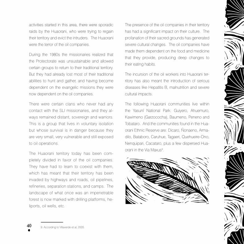
�0
activities started in this area, there were sporadic
raids by the Huaorani, who were trying to regain
their territory and evict the intruders. The Huaorani
were the terror of the oil companies.
During the �9�0s the missionaries realized that
the Protectorate was unsustainable and allowed
certain groups to return to their traditional territory.
But they had already lost most of their traditional
abilities to hunt and gather, and having become
dependent on the evangelic missions they were
now dependent on the oil companies.
There were certain clans who never had any
contact with the SLI missionaries, and they al-
ways remained distant, sovereign and warriors.
This is a group that lives in voluntary isolation
but whose survival is in danger because they
are very small, very vulnerable and still exposed
to oil operations.
The Huaorani territory today has been com-
pletely divided in favor of the oil companies.
They have had to learn to coexist with them,
which has meant that their territory has been
invaded by highways and roads, oil pipelines,
refineries, separation stations, and camps. The
landscape of what once was an impenetrable
forest is now marked with drilling platforms, he-
liports, oil wells, etc.
The presence of the oil companies in their territory
has had a significant impact on their culture. The
profanation of their sacred grounds has generated
severe cultural changes. The oil companies have
made them dependent on the food and medicine
that they provide, producing deep changes to
their eating habits.
The incursion of the oil workers into Huaorani ter-
ritory has also meant the introduction of serious
diseases like Hepatitis B, malnutrition and severe
cultural impacts.
The following Huaorani communities live within
the Yasuní National Park: Guiyero, Ahuemuro,
Kawimeno (Garzococha), Baumeno, Peneno and
Tobataro. And the communities found in the Hua-
orani Ethnic Reserve are: Dicaro, Ñonaeno, Arma-
dilo, Bataboro, Caruhue, Tagaeri, Quehueire-Ono,
Nenquipari, Cacataro, plus a few dispersed Hua-
orani in the Via Maxus9.
9. According to Villaverde et al, 2005.
�1
The Kichwa Communities
The indigenous people of Kichwa are the largest
population group within the area of influence of the
Yasuní National Park.
There are Kichwa settlements along the southern
flank of the Napo River: Llanchama, Alta Florencia,
Puerto Quinche, San Vicente, Puerto Miranda, Sin-
chi Chicta, Chiro Isla, Samona Yuturi, El Edén, San
Roque, Sani Isla, Centro Añangu, Bello Horizonte,
Nueva Providencia, Indillama, and Pompeya.
Along the Via Aucas: Rumipampa, Mandaripan-
ga, Rio Tiputini and San Juan del Tiputini. In the
northwestern part of the Huaorani Ethnic Reserve
there are two communities: Jumando and Jose
Tanguila. Along the banks of the Curaray River:
Pavacachi and Lorocachi.
Each of these communities has extensive lands
to ensure the future of new generations (Huasha
Causana Allpa). The Kichwa communities occu-
py a total extension of land of �40,95� Ha, with a
population of 6,05� persons�0.
The communities of Divino, Centro Man-
duro, San Luis de Armenia and Patasyacu
have tried to enter the northwestern part of
the Park following the banks of the Tiputini
River, causing conflicts with other communities.
These communities have diverse cultural traditions.
The communities located along the banks of the
Napo and Curaray Rivers have kept their traditional
practices while those located in the Via Aucas, who
have more contact with the exterior world, have had
to modify their traditions because of their difficulty
in finding natural resources for survival (for example
hunting animals and fishing). The communities that
live closer to towns or military bases even raise live-
stock to provide them with meat.
They still maintain the practice of keeping small
agricultural parcels next to their homes, where they
cultivate subsistence and medicinal plant crops,
and a few that are sold in the market, like coffee,
corn and rice.
The communities that are totally inside the Yasuní
National Park have no legal titles to their lands; they
simply sign “assignment and management” agree-
ments with the Ministry of Environmental Affairs.
The Shuars
With the opening of the roads built by the oil com-
panies, many Shuars arrived to the Area of Influ-
ence of the YNP (Yasuní National Park), settling
around the Via Aucas area, establishing Shuar
Centers (which is the organizational method for
this population).
10. According to information from FCUNAE, gathered by Villaverde et al, 2005.

�2
They started settling in this zone in the beginning
of the �970s, and a new colonization boom took
place in the �990s. Most of these people do not
have legal titles to their lands.
The Shuars have kept their traditional agriculture,
hunting and fishing styles. In addition, they still re-
spect the concept of nuclear families that live �00
meters away from the extended families, where
they establish their crops. However, many of their
practices are similar to those of the farmers who
also live along the Via Aucas.
The Shuar Centers established in the area are:
Atahualpa, San Vicente, Tsakimp, Tiguano, Tiwi-
ran, Saarentsa, Sasaim, San Antonio, Nantip, San
Francisco, Jura, San Carlos, Kunkuk, Peas, and In-
iayua. They have approximately �,000 persons��.
The Peasants
The arrival of settler peasants was the result of the
construction of roadways to service the oil com-
panies, particularly the Via Aucas. A State policy
promoted the colonization of the Amazon in the
�970 decade. Each settler received 50 hectares
of land to be “worked” in, which included forest
logging permits. The first colonization line opened
up the agricultural frontier creating illegal settle-
ment agents like land traffickers, professional set-
tlers who sold their worked lands and professional
leaders who organized the colonization.
At the moment there are hundreds of peasant cooper-
atives grouped in different second-level organizations.
The main product among the farmers who settled in
the area is coffee, which represents 70% of the fam-
ily incomes. Due to sanitary and technical prob-
lems, the coffee has dropped its yield so they have
started growing cacao and rice. Other activities
include livestock (in a smaller scale) and logging.
The logging of the forests has generated a dramat-
ic deforestation process all along the Aucas Road.
OTHER AGENTS
The Armed Forces
The Armed Forces are actually working for the oil
companies because they have signed agree-
ments with them whereby the oil companies pro-
vide them with facilities and the Armed Forces pro-
vide them security.
The presence of the Armed Forces inside the Park
and among the communities that have settled in
the Park has generated a situation of discomfort
among the local communities. For example, in
the community of El Eden, the military forces have
11. According to Villaverde et al, 2005.

�3
built barracks a few meters away from the com-
munity center, which has caused great discomfort
among the population.
The Conservation and Research Organizations
Several conservation and biological research or-
ganizations carry out activities inside the Park, ac-
tivities that are not reported to civil society. These
organizations make decisions regarding the des-
tiny of the park through a group called Technical
Advisory Group for the Park (TAG). For example,
with respect to the environmental permit granted
by the Ministry of Environmental to Petrobras for
the construction of infrastructure necessary for
the development and production of the block, the
TAG made a series of recommendations, some
of which attempted against the conservation of
the Park, and that were accepted by the parties
involved (Ministry of Environmental and Petrobras),
like placing an Oil Facilitation Center (facility where
most of the toxic waste is produced, within the
protected area).
On the other hand, these organizations manage
the National Park’s biodiversity with no control,
even when this biodiversity is strategic for the sus-
tainability of Ecuador.
The organization of Huaorani People.
The Yasuní Scientific Station – Pontific Catholic
University of Ecuador (PUCE)
The Station is located on the right bank of the Tiputini
River, a small distance away from the confluence with
the Tivacuno River, in the Yasuní National Park/Yasuní
Biosphere Reserve and the Huaorani Ethnic Reserve,
to the southeast of the district of Francisco de Orel-
lana (Coca), province of Orellana. Its geographi-
cal coordinates are 76º�6’ West by 00º��’ South.
Through INEFAN’s Resolution 002, dated August 25
�994, the Department of Biological Sciences of the
Faculty of Exact and Natural Sciences of the Pontific
Catholic University of Ecuador (PUCE) was granted
the administrative and technical-scientific manage-
ment of the Station that was funded by Maxus (Oil
Company) through an agreement with the INEFAN.
The Yasuní Scientific Station has an agreement with
ONHAE to develop ethno-botanic studies and other
scientific activities.
The entrance to the Station is through block �6,
by Pompeya, which is located on the left bank of
the Napo River. The Napo River barge that runs
from North Pompeya to the control post at South
Pompeya belongs to Repsol (who bought Maxus)
and has no fixed schedule. Another entrance is
through a charter of Repsol/AEROGAL up to Coca
and at ��:00 an Repsol motorboat (“Napo Belle”)
provides transportation down the Napo River to

��
South Pompeya, where the
Repsol offices are located.
The company’s guards
check and control IDs and
hold any personal documents
until departure. Repsol’s fluvial ser-
vices and the Station’s land services are then used.
These examples are a demonstration of the control
exerted by the oil company.
Tiputini Biodiversity Station – San Francisco
University of Quito (USFQ)
The Tiputini Biodiversity Station, adjacent to the Ya-
suní Biosphere Reserve, is located to the North of
the Tiputini River, a tributary of the Napo River. It
holds 650 hectares and is a project developed by
the San Francisco University of Quito in collabo-
ration with Boston University, mainly for research,
education and conservation. The entrance is lo-
cated in block �6, in Pompeya. As in the previous
case, Repsol’s guards check and control IDs and
hold any personal documents until departure.
This organization is also a member of the Techni-
cal Advisory Group of the Park (TAG) and is very
influential regarding decisions on the future of the
park. They see no incompatibility between oil ex-
ploitation and the conservation of the Yasuní, and
they limit themselves to making recommendations
to the corporations to prevent the colonization of
its area of operations.
Others
There are other important agents, like the wood
logging companies that have been involved in vio-
lent episodes with the Huaorani people and no-
body controls them, even though they have been
withdrawing wood from the National Park.
There are also the turism agencies that work
closely with the Huaorani communities, and the
conservation and development organizations.
LEGAL STATUS OF THE NATIONAL PARK
A large portion of the Huaorani traditional territory
was declared a protected area on July 26, �979,
receiving the name of Yasuní National Park. This
declaration was made official through the Inter-
Ministerial Decree No. 0�22, published in the PO.
69 of November 20, �979. The size of the Park
was 67�,000 hectares.
The objectives of the declaration were clearly
conservationist since there was no mention of
the local populations.

��
The initial extension was 679,000 hectares.
In April �990 the boundaries of the Park were
amended through Ministerial Agreement of MAG
dated April 2nd. One of the reasons behind the
change of boundaries was the recognition of the
rights of the Huaorani people to their territory.
So on April �rd the Huaorani Ethnic Reserve was
created, with an extension of 6�2,650 hectares.
To this surface they added the area of the Protec-
torate, created by the Summer Linguistics Institute
(SLI), of 66,570 hectares.
With the creation of the Huaorani Ethnic Reserve, the Ya-
suní National Park was reduced to 544,7�0 hectares.
In �992, through Ministerial Agreement 0202 of May
�6, the Park’s extension was expanded to 9�2,000
hectares. The reasons behind this amendment in-
cluded the recognition of the traditional Huaorani
settlements, and the recognition of the ecosys-
tems that require ecological integrity.
But the truth was that they were actually excluding
from the boundaries of the Park the area of Block
�6 (at the time operated by Conoco) and extend-
ing the boundaries from another end.
During the creation of the park the ethnic aspects
were not taken into account because during that pe-
riod the conservation model did not include people.
In �9�9 the Park was declared a UNESCO Bio-
sphere Reserve, including the Huaorani territory.
The Political Constitution of the Republic of Ecua-
dor, in its Article 2�, paragraph 6, states that: “with-
out prejudice to the rights established by this Con-
stitution and the international instruments in force,
the State will recognize and guarantee the people
the following: the right to live in a healthy environ-
ment, ecologically balanced and pollution free”.
In addition, the Forestry Law in force in Ecuador
does not allow oil activities in protected areas, in-
cluding National Parks that hold the highest status
of conservation in Ecuador. This law is in direct
contradiction with the Hydrocarbons Law that fa-
vors the extraction of non-renewable resources to
the detriment of conservation.
As the Yasuní Park entered the Global Network of
Biosphere Reserves upon request from the gov-
ernment of Ecuador, its management must concur
with the Seville Strategy. This strategy sets forth
the only activities that are allowed in a biosphere
reserve to guarantee the balance between the
environment and local populations, from a socio-
cultural and non-pollutant perspective. No unsus-
tainable activities, like oil production, are allowed in
biosphere reserves.

��
The Precautionary Principle,
provisioned under Article 9�
of the Constitution, forces the
State to take preventive mea-
sures where there are doubts
about negative environmental
impacts or consequences
from any action or omission,
including prohibiting authorizations for the construc-
tion of oil infrastructure. In the case of oil exploitation,
the potential damage to the ecosystem is real, there
is no doubt about it; therefore the preventive mea-
sures become more reasonable for the State.
The development of oil exploration and exploi-
tation activities in the Yasuní National Park are
incompatible with the adequate and sustain-
able management of a biosphere reserve and
the fact that the Ecuadorian State allows said
activities is a clear violation of the international
agreements ratified by the government with
respect to UNESCO’s Global Network of Bio-
sphere Reserves.
On January 29, �999 two Intangible Zones were
declared. The first one is the Cuyabeno Wildlife
Reserve (Executive Decree 55�), and the second
one is the southern portion of the Yasuní National
Park (Executive Decree 552). The decrees were
published in the RO. �2� of February 2, �999.
The text of the Executive Decree 552 reads:
Article 1. Declare the living and development
lands of the Huaorani people known as Tagaeri,
Taromenani and others that remain in total isola-
tion, located to the South of the lands assigned to
the Huaorani people in �990 and of the YNP, as an
intangible conservation zone, banning for perpe-
tuity all types of extraction activities.
Article 3. The aforementioned intangible zone will
have an extension of approximately 700,000 hect-
ares situated in the parishes of Cononaco and
Nuevo Rocafuerte, district of Aguarico, province
of Orellana, and in the parish of Curaray, district of
Pastaza, province of Pastaza.
Part of the intangible zone is inside the oil block �7
(operated by Encana).
OIL EXPLOITATION IN THE PARK
During the �9�0s, Shell was the first oil company
to carry out prospecting activities in what today is
known as the Yasuní National Park. They found
heavy crude reserves; however at the time there
was no technology available to allow its transporta-
tion, so they abandoned their exploration activities.
Later, in �967, Texaco discovered economic
amounts of oil to the north of the Huaorani territory.

��
Currently, it is estimated that 60% of the Yasuní Bio-
sphere Reserve has been granted under conces-
sions to oil companies.
Following is a detail of the problems that are asso-
ciated with some of these oil producing areas.
Block 15 – Occidental
Only one portion of the Block affects the Northern
part of the YNP, but it does affect all of the Park’s
buffer zone.
Occidental received incentives from the State
when they were granted the Eden Yuturi field.
Due to its location, 75 Km from the Shushufindi
field (assigned to Petroecuador) and close to Oc-
cidental’s Block �5, it was decided to share the
exploitation of the oil field. Estimated reserves are
�5�.9 million barrels for an extraction period of 20
years, with a maximum production of 46 wells with
44,500 barrels per day.
According to satellite images, it is very likely that
they have built an illegal road inside the Park’s
buffer zone.
Block 31 – Petrobras
Practically the entire block is within the Yasuní Bio-
sphere Reserve, affecting the Yasuní National Park
and the Huaorani Ethnic Reserve. It limits to the south
with the intangible zone, and a portion of the Block
is part of the migratory territory of the isolated indig-
enous communities of Tagaeri and Taromenani.
On August 25, 2004, and coinciding with the ar-
rival of the Brazilian President, Luis Inacio Lula de
Silva, the Ministry of Environment granted an Envi-
ronmental Permit to Brazil’s state-owned company
Petrobras for the development phase of the Project
Development and Production of Block �� in the
Nenke and Apaika fields, which was subject to the
approval of an Environmental Impact Assessment
(EIA) and a Plan for Environmental Management.
The EIA was approved despite the dreadful short-
ages that made it absolutely unacceptable, espe-
cially if we take into account that it would be applied
in an area of extreme ecologic fragility.
Later, in March 2005, a new environmental permit
was granted to Petrobras. This new permit al-
lowed them to log more than 20 thousand cubic

��
meters of trees from Yasuní’s virgin forests so that
the corporation could open their roads and access
routes, and build two oil rigs from which they would
drill �2 wells to extract crude from the core of the
Yasuní. For destroying this area of the Yasuní, they
are charged the pitiful sum of 60,000 dollars.
Block �� is located in the heart of the Yasuní
National Park.
Even the Environmental Impact Assessment (EIA)
recognizes that the road and the oil pipeline that
Petrobras pretends to build will go through mature
hillside forests, alluvial plains, crossing � river con-
fluences, and ��0 swamps. This route contains the
largest biodiversity of animals and plants, and con-
tains many endemic and endangered species.
Blocks 14 and 17 – ENCANA
Approximately 65% of
Block �4 is inside the
YNP. A portion of Block
�7 is located in the in-
tangible zone.
The French oil company
Elf Aquitane (through its
subsidiary Elf Hidrocar-
bures Equateur) signed
in �9�7 a joint venture
agreement with the Republic of Ecuador whereby it
was stipulated that if the endeavor turned out to be
economic, then the State would pay for all the in-
vestments made. In �994 it granted in concession,
through a strongly criticized contract, a marginal oil
field with proven reserves (Shiripuno �) that would
help increase the corporation’s production.
The operation affects the indigenous communities
of Rio Tiputini, San Juan de Rio Tiputini, the Shuar
Association of Centers, and the indigenous and
settler communities of Rodrigo Borja and Rumi-
pampa. These communities have repeatedly re-
quested support for their activities because their
daily routines have been modified since the ar-
rival of the company, but the response has always
been negative.
To carry out their operations, the company built
a 2�.5 Km highway and an additional side road
of �.5 Km, that together with the highway built by
Texaco (Via Aucas) and the road built by Maxus in
Block �6 (Via Maxus), form a network of roads that
deeply divides the territory of the Yasuní National
Park. And this division could be even larger be-
cause they are planning to build new roads to link
the Pañacocha field and Block 20 (ITT fields). Elf’s
highway has a rolling width bigger than the one de-
clared in the Environmental Impact Assessments
(5 meters) because in certain sectors it goes over

��
� m plus the �-meter ditches on each side, and
up to �0 m for the passage of the oil pipeline. The
company declared that it would not foster coloni-
zation, but the Rodrigo Borja Pre-Cooperative, for
example, has grown from �� to �5 families in less
than �0 years, with no property titles but with pos-
session minutes granted by the IERAC – Ecuador-
ian Institute for Agricultural Reform (currently INDA
– National Institute for Agricultural Development).
In �997, Elf transferred its installations to Vintage
Oil, and later to the Canadian company Encana.
The oil produced in Encana’s installations is heavy
crude that needs to be mixed with light crude from
the Auca Sur Station (property of Petroecuador)
as a diluting substance. The production contains
40% crude from Petroecuador. The formation wa-
ters from the company (400-500 barrels per day)
are treated with biodegradable products (like Bio-
Stein, Bio-Digest, etc.) and discharged in the area,
to an estuary that crosses Pindo 2 Station and then
unloads in the Tiputini River, seriously affecting the
local communities on a daily basis. The oil pipe-
line also has frequent spills in the area because
the infrastructure is obsolete and in bad shape.
By the end of 2002 the Canadian company En-
cana announced the acquisition of Blocks �4 and
�7 from Vintage. At the beginning of 2004 they
started expanding the production of the block,
which means the undertaking of a seismic pros-
pecting survey in �70,000 Ha, half of which will be
done inside the YNP.
Block 16 – Repsol
In January �9�6 Block �6, located in Huaorani tra-
ditional territory and inside the Yasuní National Park,
was granted to the following corporations: Conoco
Ecuador Ltd.; Overseas Petroleum and Investment
the Corporation; Diamond Shamrock South America
Petroleum B.V.; and Nomeco Latin America Inc., for
the exploration and exploitation of hydrocarbons.
The Ministry Agreement No. �9� of April 2, �990,
published in R.O. 40�, reduces the territory of the
park to exclude Block �6 and transferring it to Hua-
orani Territory. For this reason the Corporation for
the Defense of Life submitted a claim before the
Court of Constitutional Rights stating that accord-
ing to Article �07 of the Forestry Law, protected
areas can only be used to preserve the ecolog-
ic, esthetic and cultural features of the land, and
therefore its amendment to turn it into indigenous
territory (and allowing oil extraction) was unneces-
sary and inconvenient.
In �9�9, once the exploratory phase was conclud-
ed, it was decided that the block was uneconom-
ic; however, Conoco and later Maxus, remained as

�0
operators and majority stakeholders of Block �6.
In �99�, Maxus took over the operations that
Conoco had previously begun in this block.
Later, Maxus was bought by the Argentine an
YPF and this by the Spanish Repsol.
Block �6 has not yielded economic results for
the country, and even worse, it has generated a
series of socio-environmental conflicts that are
very difficult to solve.
The seismic surveys caused the deforestation
of approximately �,��7 hectares for the con-
struction of heliports, and the French company
CGG opened 2,6�4 Km of seismic lines. Sev-
eral times during operations, the Directorate
of Hydrocarbons had to fine CGG (Conoco’s
sub-contractor) for dumping the waters from
the drilling residues pools and waste. The drill-
ing residues were used as construction material
for the road that crosses Huaorani territory and
the YNP, as well as in talus and platforms. The
fluids were dumped into rivers and estuaries of
the Park, almost untreated, even though they
said that 54% would be recycled. We must re-
member that Maxus implemented the direction-
al “cluster- type” drilling, which makes physical
presence in each well unnecessary, but gen-
erates more drilling waste. They built several
�0,000-meter pools.
In the Northern part they built the so-called Via
Maxus (Maxus Roadway), with an extension of ��0
Km. The work was done by sub-contractor An-
drade Gutierrez, a Brazilian company with a lousy
environmental history in the construction of road-
ways in tropical forests, having been sanctioned
and banned from doing business with the Bra-
zilian State for corruption of public officials. This
company caused the outbreak of cholera among
the people who worked in the indigenous area of
Pompeya due to the poor hygienic conditions of
the food, although the company never accepted
this situation. It is said that the roadway was built
following a rigorous environmental study. However,
it has been estimated that it crosses 540 estuaries
that were stagnated affecting also wetland areas,
removing 45 million cubic meters of red clays that
were openly dumped into the estuaries. The ta-
luses were replanted with Asian and African grass
species (Bracharia decumbens and Desmodium
sp.), good for livestock and considered extremely
aggressive with natural vegetation because they
compete with each other hindering the natural
regeneration of the forest. In some cases – as
mentioned before – they used the drilling residue,
with highly toxic and recalcitrant substances, as
building material for the roadway. The first 5 kilo-
meters of the Via Maxus encountered 6 archaeo-
logical sites. During the construction process they

�1
destroyed between �0 and 50 sites used for feed-
ing and breeding purposes by species that have
enormous symbolic value for native people.
Several Huaorani and Kichwa communities have
settled along what is called today the Via Maxus.
The Huaorani depend on the company to cover
their basic necessities, including feeding and
medicine, which has brought about a change in
their feeding patterns and the introduction of new
diseases linked to oil production.
Repsol is responsible for the management of the
National Park. Hiding behind the argument that they
are preventing colonization, they have obstructed
civil society organizations from independently con-
trolling and monitoring their activities, yet allowing the
operation of illegal actions such as tree logging. This
is a clear violation of national sovereignty.
The entrance to the National Park is completely con-
trolled by the company, who does not recognize
permits granted by the Ministry of Environment, by
the Office of the National Park, by the Ministry of De-
fense, or by the Huaorani communities settled along
the highway built by the company.
Despite Repsol-YPF’s control, several problems
related to illegal tree logging have been regis-
tered, even in the intangible zone (so declared by
Executive Decree No. 522 of January 22, �999).
There are no controls
over the extraction or
transportation of the
wood, even though
they have to pass mili-
tary control posts, and
the existence of con-
trols for all the people who enter the Park. Repsol
YPF has expressed that this is the responsibility of
the Ministry of Environment.
The crude in this block has �6 degrees API, with a
formation water content of up to 90%. This crude
has a high level of sulphur, highly corrosive, which
means that the life span of the oil installations will be
very short and the environmental problems caused
by spills and other accidents will be frequent in the
short term. There have already been a number of
crude spills in the oil pipeline and in the wells, a
fire in the installations and several chemical leaks
during its transportation along the Napo River. For
example, during �994, three barges transporting
drilling supplies and chemicals capsized in the
Napo and Tiputini Rivers losing their loads.
ITT Project – Petroecuador
Petroecuador has the largest oil project, with prov-
en reserves of more than �00 MMBO of heavy
crude in the fields Ishpingo-Tambocha-Tiputini, all
located inside the YNP.

�2
These fields were discov-
ered by the state-owned
company Petroecuador.
The Government of Lucio
Gutierrez hired a French
company to rediscover
the field.
Currently there are 4 oil
wells in the ITT.
Besides the drilling wells, the project includes
production stations, �5 Km of multifaceted pro-
duction line from the platforms to the Tiputini
central station, �5 Km of recycling formation
water line to the �7 wells in the western flank
of the field, the Tiputini-Shushufindi oil pipeline,
and the generation of 4� MW of electricity at the
Tiputini central station.
They also pretend to refine the crude of this
block, which is very heavy, inside the Yasuní
National Park.
This block will be tendered during the next Oil
Bidding Round. This way they are creating a
new threat to Yasuní, with the only purpose of
favou ring the transnational oil power.
RISK RELATED WITH THE OIL ACTIVITIES
The pristine tropical forests of Yasuní have been
the location for the oil companies to build roads for
the seismic surveys. In order to provide supplies
to the oil workers’ teams, they have built hundreds
of heliports in the middle of the forest.
Then, they continued building drilling platforms,
camps, wells, roadways, heliports, oil pipelines and
other oil infrastructure. In a recent operation close
to a Huaorani community they have logged more
than 2,500 trees to install their oil infrastructure.
The noise from the drilling operations is perma-
nent, as is the noise from the helicopters and other
vehicles and from the functioning of the oil infra-
structure. It is difficult to believe that this used to
be the home of the Huaorani people where silence
was an indispensable requirement for hunting.
Paradoxically, oil workers like to go hunting. The
impact can be greater during seasons when they
require extra workers. They hunt not only to eat but
also to trade the wildlife species, some of which
are in danger of extinction.
One of the main problems associated with oil ac-
tivities is pollution. The Yasuní forests are flooded
during several months of the year. If there is a

�3
spill or leak, the pollution will eventually reach these
flooded forests, moving then to the estuaries and
the rivers. The Tiputini River, under the influence of
oil companies, holds the fisheries world record for a
hydrographic basin of its size. The Amazon people
depend on the waters of the rivers to cover their
bare necessities, like fishing, cooking and hygiene.
Pollution is produced by the generation of oil
wastes that are not adequately treated, and by the
wastes produced by the oil workers. In many cas-
es, normal crude dripping are constant sources
of pollution. Although not very common, there are
also accidents that have very serious impacts.
When the crude gets to the water, the heaviest
components tend to sink into the sediments, be-
coming a constant source of water pollution, af-
fecting the organisms that live in the bottom of the
rivers and lakes.
Some oil-associated contaminants produce altera-
tion among fish communities, increasing the popula-
tions of the more resistant species and diminishing
or exterminating the less resistant species. Many lo-
cal people have complained that fishing is no longer
the same as in the past, or that the fish are abnormal.
There have also been cases of chronic poisoning of
inhabitants that use the water and eat the fish from
these polluted rivers and lakes.
Together with the crude, the oil companies extract
burning gas. In areas close to the stations where
they flare gas, there have been acid rains with high
contents of very cancerigenous hydrocarbons.
So the populations that live close to oil installations
face critical health conditions. A study that inter-
viewed people who live 500 meters away from oil in-
stallations in another part of the Ecuadorian Amazon
found that from the �,520 families interviewed, �,252
had suffered diseases related to oil pollution.
The community relation lobbyists
If during the Texaco period the Huaorani were vio-
lently subjugated through the displacement from
their ancestral territories, the oil companies that are
working today in Huaorani territory and in the Yas-
uní National Park use more modern and maybe
more effective methods to achieve their interests):
the community relation lobbyists

��
These community lobbyists are usally anthropolo-
gists who specialize in the ethnic group they are try-
ing to subdue: in this case, the Huaorani people.
Due to the absence of the State in the Amazonian
region, oil companies are responsible for providing
certain basic and elemental services to the indig-
enous communities. And the community lobbyists
negotiate with the indigenous groups to allow the en-
trance of the oil companies in exchange for tin roofs,
rice, sugar, candy, balls, whistles and other goods.
When the communities realize that they have been
cheated because the goods run out, and they
have to live with the pollution, the lobbyists make a
new entrance offering them more goods.
In a movie about the Huaorani people, they de-
scribe how community lobbyists convinced
the Huaorani to sign a 20-year agreement with
Maxus Oil Co. The company was to make cash
payment in exchange for being allowed to work
in the area. At the end of the movie we see a
woman, who played the role of the President of
the United States, invited to witness the signing of
the agreement. She took her golden earrings and
gave them to a Huaorani woman. In exchange
the Huaorani woman gave her a crown made of
forest fibers and placed it on the North American
woman’s head. Then the North American woman
says in English: “this is how we won Manhattan,
with trinkets and mirrors”.
The community lobbyist that orchestrated the signing
of the agreement became the advisory counsel to all
the oil companies that were to arrive to the Ecuador-
ian Amazon, especially in the Huaorani territory.
As a result, the Huaorani people hold similar
agreements with several companies. The ONAHE
receives money from the companies and an exter-
nal observer would say that it is spent irrationally.
And the reason is the Huaorani people have never
lived in a market economy. They are a gathering
group. The money that the oil companies pay
them is equivalent to any other good they pick up
in the forest; but money produces very serious
cultural impacts.
Part of the strategy implemented by community
lobbyists is to disregard the traditional leaders,
those who have been in charge of preserving the
traditional balance of the group, and instead treat
the younger members of the groups as the lead-
ers of the indigenous organizations because they
have had some access to formal education, they
speak Spanish, and due to their youth are more
vulnerable to the temptations generated by the oil
industry. The elders and the wise men are totally
ignored, upsetting their culture.
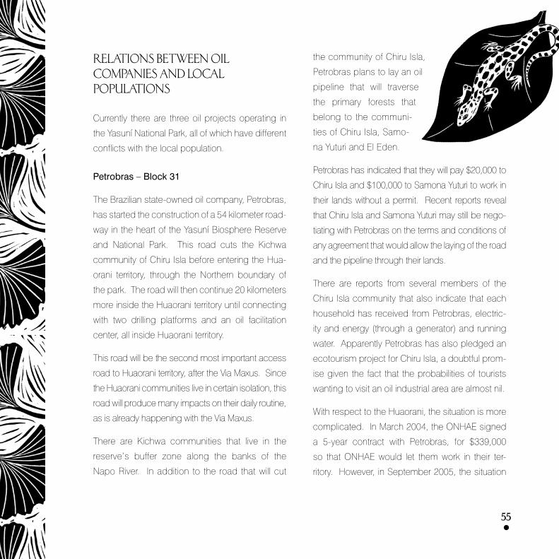
��
RELATIONS BETWEEN OIL COMPANIES AND LOCAL POPULATIONS
Currently there are three oil projects operating in
the Yasuní National Park, all of which have different
conflicts with the local population.
Petrobras – Block 31
The Brazilian state-owned oil company, Petrobras,
has started the construction of a 54 kilometer road-
way in the heart of the Yasuní Biosphere Reserve
and National Park. This road cuts the Kichwa
community of Chiru Isla before entering the Hua-
orani territory, through the Northern boundary of
the park. The road will then continue 20 kilometers
more inside the Huaorani territory until connecting
with two drilling platforms and an oil facilitation
center, all inside Huaorani territory.
This road will be the second most important access
road to Huaorani territory, after the Via Maxus. Since
the Huaorani communities live in certain isolation, this
road will produce many impacts on their daily routine,
as is already happening with the Via Maxus.
There are Kichwa communities that live in the
reserve’s buffer zone along the banks of the
Napo River. In addition to the road that will cut
the community of Chiru Isla,
Petrobras plans to lay an oil
pipeline that will traverse
the primary forests that
belong to the communi-
ties of Chiru Isla, Samo-
na Yuturi and El Eden.
Petrobras has indicated that they will pay $20,000 to
Chiru Isla and $�00,000 to Samona Yuturi to work in
their lands without a permit. Recent reports reveal
that Chiru Isla and Samona Yuturi may still be nego-
tiating with Petrobras on the terms and conditions of
any agreement that would allow the laying of the road
and the pipeline through their lands.
There are reports from several members of the
Chiru Isla community that also indicate that each
household has received from Petrobras, electric-
ity and energy (through a generator) and running
water. Apparently Petrobras has also pledged an
ecotourism project for Chiru Isla, a doubtful prom-
ise given the fact that the probabilities of tourists
wanting to visit an oil industrial area are almost nil.
With respect to the Huaorani, the situation is more
complicated. In March 2004, the ONHAE signed
a 5-year contract with Petrobras, for $��9,000
so that ONHAE would let them work in their ter-
ritory. However, in September 2005, the situation

��
changed radically because ONHAE underwent an
electoral process and the 400 Huaorani delegates
that represented �� leading communities reject-
ed oil activities. The new leadership condemned
the Petrobras agreement approved by the former
leadership, accusing the ex-President of signing a
secret treaty without the support of the Huaorani
communities. The new leadership rejected im-
mediately new oil projects in Huaorani territory and
they have been investigating legal mechanisms
trying to find a void in the contract with Petrobras.
However, it is not clear how the new leadership will
respond once Petrobras begins the construction
of roadways in their ancestral territory.
To complicate things even more, the Huaorani com-
munity of Kawimeno is not opposed to Petrobras’
project. Kawimeno is the only Huaorani community
that would be directly affected by the project.
Block 15 – Occidental
It has been recently discovered that Occidental
(Oxy) has been building a clandestine highway
through the virgin tropical forests of the Kichwa
community in El Eden, in a critical buffer zone of
the Yasuní Biosphere Reserve.
Notably, in their 200� Health, Environment and Se-
curity Report Oxy lied about the existence of this
roadway. Oxy includes the Eden-Yuturi project in
the report as a remarkable example of sustainable
development. They state that the reasoning be-
hind the decision to not build a roadway was to
avoid colonization.
However, satellite images reveal that from August
2000 until today, Oxy has been building a net-
work of roads that extends to the deepest primary
forests of the El Eden community. This network
seems to have at the moment a length between
20 and �0 kilometers, servicing 7 drilling platforms
and a massive oil processing center, all within the
territory of the El Eden community. The latest plat-
form is located less than 5 Km from the boundary
of the Park and � Km from the platforms and their
respective roads that are in the official buffer zone
of the Biosphere Reserve.
In only 4 years, Oxy has transformed the virgin for-
est of the community of El Eden into an important

��
industrial operations field. In 200� Oxy and the
community of El Eden signed a 20-year agree-
ment. Although the terms of the agreement are
confusing, it states that in exchange for the right
to use the land of the communities for oil exploita-
tion, Oxy will build a community house, a school,
a health center and will pay each household $�00
(a report indicates that Oxy paid $20,000 to the
community of El Eden, where most of the money
landed in the hands of community leaders).
In addition, a recent article published in the news-
paper El Comercio� of Quito, the President of the
community of El Eden expressed his anger with
Oxy for the environmental damage caused in the
community because they discharge the untreated
formation waters from the wells to the rivers. The
President also said that the community had filed a
complaint before the Ministry of Energy and Mines
for the environmental damages caused by an oil
spill 7 kilometers from the community house.
ENCANA – Block 14
The Canadian oil company Encana began a mas-
sive seismic prospecting campaign within lands
of the Kichwa communities, located in the south-
ern part of the reserve’s buffer zone. However, in
an audacious move, three of these communities
(Sani Isla, Añangu and San Roque) sent an official
letter dated July 29 2004 to the Ministry of Environ-
ment opposing future oil activities in their lands.
The letter says: “we do not agree and we will not
allow the entrance of oil companies to develop oil
activities because the damages would be irrevers-
ible” and it will happen in “the middle of our land”.
The letter was signed by the Presidents of the
communities of Sani Isla and San Roque.
The three communities are the legal owners of ap-
proximately 6�,000 hectares, most of which are in
primary wet tropical forests within the buffer zone
of the Biosphere Reserve. Blocks �5 (Oxy) and �4
(Encana) are situated in this land.
It is important to note that two of these communi-
ties, Sani Isla and Añangu, have successful eco-
tourism projects that depend on the intactness
and healthiness of their primary forests.
RESISTANCE
Many forms of resistance have been undertaken
to confront the problem of the oil industry in the Ya-
suní National Park. They have been carried out by
indigenous and non-governmental organizations,
both nationally and internationally.
12. Published on September 2�, 2005.

��
Actions undertaken by indigenous organizations
The first initiative to defend the Huaorani people
from the raids of the oil industry was carried out by
CONFENIAE with the support of Sierra Club Legal
Defense Fund. They presented a complaint before
the Inter American Commission for Human Rights
at the Organization of American States, accusing
the Government of Ecuador and the oil compa-
nies for attempting against the human rights of the
Huaorani people by authorizing and developing oil
extraction in their territory. This process received
international and national attention and finally was
won by the plaintiff.
The recommendations of the Commission,
dated April 24, 1997, were the following:
“The Commission
recommends that
public officials, partic-
ularly those involved
in the administration
of justice and law en-
forcement, receive
appropriate training to
respect the rights of
indigenous individu-
als, and appropriate
supervision to ensure
that pubic services are performed in a non-discrimi-
natory manner.
The Commission recommends that the State take
the measures necessary to ensure, not only that
its agents refrain from violative conduct, but that
reasonable measures are taken to prevent dis-
crimination within the private sector, and to ensure
that when it occurs, it is treated as a human rights
violation subject to appropriate sanctions.
Remedying discrimination also requires that atten-
tion be given by the State to ensuring a more equi-
table distribution of resources and social spending
in areas with heavily indigenous populations.
Respect for indigenous expression, religion and
culture implies special dispositions on the part of
the State to ensure, for example, that bilingual edu-
cation is available; that study plans and materials
adequately reflect, communicate and respect the
culture of the tribe; and that efforts are made to train
teachers from within indigenous communities.
Given that the protection of the rights of indig-
enous individuals and communities affected by
oil and other development activities requires that
adequate protective measures be put in place be-
fore damage has been suffered, the Commission
recommends that the State take the measures
necessary through the INDA and other agencies to

��
restrict settlers to areas which do not infringe upon
the ability of indigenous peoples to preserve their
traditional culture.
Such protection further requires that the State take
the measures necessary to ensure the meaning-
ful and effective participation of indigenous rep-
resentatives in the decision-making processes
about development and other issues which affect
them and their cultural survival. “Meaningful” in this
sense necessarily implies that indigenous repre-
sentatives have full access to the information which
will facilitate their participation.
The Commission encourages the State to take the
steps necessary to resolve pending claims over
the title, use and control of traditionally indigenous
territory, including those required to complete any
pending demarcation projects.
The Commission recommends that the State take
whatever measures are necessary to guarantee
the lives and physical integrity of the Tagaeri, and
any Taromenani and Oñamenane who may survive
in the forest, such as the establishment of some
form of legal protection for the lands they inhabit,
as their very extinction as peoples is at issue.”
Yet, the conditions of the Huaorani people far from
improving have worsened.
When Block �6 was operated by Conoco, a group
of North American lawyers came up with a propos-
al to create the “Napo River Foundation” whose
purpose was to create a trust fund that would be
used to restore the cultural damages caused by
Conoco’s activities over the Huaorani people.
Since they would no longer be able to hunt, they
would be able to live from the interest earned by
the trust fund. This trust fund had worked well in the
Hudson River, in the United States, where a group
of fishermen had been affected by the pollution of
the river and were unable to continue fishing. But
the case cannot be extrapolated, because we are
talking about populations that have inhabited the
Amazonian forests for millennia, and such extreme
cultural changes, like stopping hunting, would im-
ply their extinctions.
Conoco stopped operating Block �6 and Maxus Oil
Company came in. They applied a new strategy
with respect to indigenous peoples and the Yasuní
National Park. Maxus used community lobbyists to
neutralize the battle with Huaorani peoples, and they
offered to turn in the oil camp that was going to be
used during the construction of the highway to an
Ecuadorian University to transform it into a scientific
research center thus liberating their environmental li-
abilities with the Yasuní National Park

�0
In October �992 the Hua-
orani peoples organized
a march to the city of
Quito to demand the
Government of Ecuador
and Maxus Oil Co. not
to intervene in their terri-
tory. Maxus had planned
to build a highway that would cross their territory
and the Yasuní National Park. In that occasion a
Huaorani leader said “why do we need a highway
if we do not have cars”. And that is because the
highway was not for them but for the oil company.
Unfortunately, the community lobbyists, supported
by the Embassy of the United States itself, man-
aged to neutralize the battle of these people, end-
ing with the signing of the �99� �0-year agreement
between Maxus and the Huaorani Peoples’ Orga-
nization ONHAE. The agreement was continued
with YPF and later with Repsol-YPF, the new opera-
tors of the Block.
The agreement with Maxus created a culture of
dependence on the oil companies, and such
agreements were signed with other companies.
However, the communities are not satisfied with
the decisions taken by the leaders of the ONHAE,
who are normally young people with a certain de-
gree of formal education.
In 2005, a Huaorani women’s organization was
formed, whose main concern is the impact of the
oil companies on their live styles.
In July 2005, this women’s organization, supported
by the bases of the ONHAE organization, made a
march to Quito, demanding the withdrawal of the oil
companies from their territory (attached is the state-
ment delivered to the President of the Republic of
Ecuador and the Ecuadorian citizens in general).
During this march, the leaders met with officials from
the Ministry of Government and the result was the cre-
ation of a Committee that would follow-up the prob-
lems caused by the oil companies in their territory.
In August 2005, ONHAE delegates met (more
than �00 representatives) to analyze many of the
problems faced by the Huaorani, especially those
related to timber and oil extraction in their territory.
The representatives read the By-Laws of the ON-
HAE. They decided that the by-laws needed to be
amended because they had been favouring the
presence of oil companies in their territory.
A representative from the Community of Kawimeno,
located in what is today Block ��, indicated that the
community should set limits in order to prevent the
entrance of oil companies into their lands.

�1
At the end of the Assembly a new board for the
organization was named. The new delegates stat-
ed that the elders played a very important role in
decision-making of the organization, especially in
those matters that had a meaningful effect on their
people, like the relationship with oil companies.
Actions undertaken by non-governmental
organizations
Many organizations have taken interest in the situ-
ation of the Yasuní National Park, and have submit-
ted complaints in different national courts to avoid
the delivery of these protected areas to transna-
tional companies. One example is the lawsuit pre-
sented by CORDAVI to the Court of Constitutional
Rights in �990.
The suit demanded the revoke of the agreement
signed between the State and Conoco for Block
�6 based on the constitutional right to a healthy
environment. At that time it was not possible to
extract hydrocarbons from protected areas.
Although the lawsuit was favorable to the plaintiff,
as a result the State took certain actions so that
Conoco could continue working in Block �6:
• The boundaries of the Yasuní National Park
were amended.
• An inter-ministerial decree was issued
through which oil exploitation was allowed in
protected areas.
Campaign “Amazonía por la Vida”
(Amazon for Life)
The “Amazonía por la Vida” campaign was created
in �9�9 to confront the oil problems in the Ecua-
dorian Amazon.
One of the main concerns of the campaign was
the presence of oil companies in the Yasuní Na-
tional Park. In coordination with international or-
ganizations, they exerted strong pressure to get
Conoco to abandon Block �6, which happened in
200�. And Maxus became the new operator.
The Campaign supported the massive mobiliza-
tion of the Huaorani people from their territory to
the city of Quito, to demonstrate against the pres-
ence of the oil company in their territory. After the
boundaries of the YNP and the Huaorani territory
were amended, Block �6 was located in its entire-
ty in Huaorani territory. In addition, they were op-
posed to the construction of a highway that would
traverse the YNP from North to South, but affecting
the Huaorani traditional territory.
The “Amazonía por la Vida” movement also dis-
played a strong campaign against the sharehold-

�2
ers of Maxus Oil Co. and the company itself, and
closely monitored the company’s first activities.
Unfortunately, the presence of the community lob-
byists weakened the opposition of the Huaorani
people, leaving only sporadic manifestations of
dissatisfaction among certain people, especially
the elders. In the end, ONHAE signed a 20-year
agreement which meant that the organization was
subordinated to the oil companies.
Campaign “Yasuní por Siempre” (Yasuní Forever)
The “Yasuní Por Siempre” campaign started in
2004, as a response to the granting of an environ-
mental permit to Petrobras.
The campaign organized a verification mission
to the Park, made up by delegates from the
countries whose companies work in the Yasuní
(Spain, Canada and Brazil) as well as delegates
from countries affected by these companies
(Colombia and Ecuador). The meeting took
place between July and August 2004 releasing
a report with their observations.
One of the issues that called the attention of the mis-
sion was that they were not allowed to stay in Yasuní
Park without the authorization of Repsol, even though
they had the permission of the YNP authorities and of
the Huaorani settled in the Via Maxus.
In August 2004, a legal recourse was presented
before the Court of Administrative Law by several
organizations (CONAIE; CEDHU; PUCE’s Clinic of
Human Rights; INREDH) against the environmen-
tal permit granted to Petrobras for Block ��. The
exemption demands:
• That the environmental permit to Petrobras to
operate Block �� be revoked, because it is lo-
cated in its entirety in the Yasuní Biosphere Re-
serve. (A high percentage of the National Park
and another from the Huaorani territory). There-
fore, the Ministry of Environmental Affairs must
prevent oil exploitation and road constructions
in Yasuní National Park.
• That an environmental audit be performed on all
the oil operations in Yasuní.
The exemption was denied by the Court of Admin-
istrative Law and by the Constitutional Court, after
the plaintiffs appealed.
At the same time, they started a campaign of letters
addressed to all the members of the Court by nation-
al and international organizations led by Oilwatch and
supported by organizations such as FIAN, Brazil’s
Rede de Justicia Ambiental, and others.
A group of concerned scientists submitted an Am-
icus to support the case, based on scientific data

�3
and the importance of the National Park. Other
scientists sent their opinions on the case, covering
social, economic and technical areas. The docu-
ment supporting the appeal recourse was written
by Acción Ecológica and Oilwatch.
The “Yasuní Forever” Campaign supports the Hua-
orani who are resisting oil activities in their territory.
They have also launched an initiative for Yasuní
without Oil, to be discussed at different levels of
the Ecuadorian society.
FOR AN OIL FREE YASUNÍ
An eco-logical call for the conservation, the
climate and human rights. A proposal for
the Yasuní Biosphere Reserve
The international ecological call aims to link all the
issues on biodiversity conservation, climate change
and the rights of the indigenous peoples as a com-
mon strategy to safe the areas of greatest diversity,
leaving unreleased carbons sequestered in the sub-
surface, supported by the Convention on Climate
Change and other international conventions through
which the governments of the world pledge to protect
biodiversity, reduce poverty, respect human rights in
general and indigenous rights in particular.
The Yasuní Biosphere
Reserve, that includes
the Yasuní National
Park and the Huaorani
Ethnic Reserve, has
an immeasurable eco-
nomic value. It is one the
Pleistocene refuges that
allowed the repopulation of the Amazon basin.
There are many voids in our scientific knowledge
regarding ecologic relations among species, we
do not known how many are in extinction due to oil
operations, road construction, tree logging and in
general anything that may cause the de-fragmen-
tation of these ecosystems.
The indigenous territory of the Huaorani People
has been deeply hit by the presence of the oil
companies. These corporations self-appoint State
functions and offer donations or sign agreements
on local, health or education development with no
comprehensive criteria that respects local culture.
These projects are merely used “to convince the
communities to give up their rights” under the un-
derstanding that they will receive “donations”. But
when the companies do not comply, which is the
general rule; they blame the State for any problem.
This brings about a situation of scarcity, conflicts
and limitations that the State cannot solve.
��
In January �999 the Southern portion of the Yasuní
National Park was declared an intangible zone to
protect the Tagaeri/Taromenani communities that live
in voluntary isolation. These areas are permanently
under pressure of the timber and oil interests.
The Republic of Ecuador, in an effort to guarantee the
rights of the indigenous populations and the protec-
tion of biodiversity, and at the same time contribute to
reduce greenhouse gas emissions, has proposed
to extract oil from the sub-surface of the Yasuní Bio-
sphere Reserve in exchange for an international as-
surance that will guarantee State income.
The hydrocarbon resources of the Yasuní Bio-
sphere Reserve can be estimated in tons of car-
bons equivalents; therefore in economic terms.
There is an international initiative from several foun-
dations and political sectors to destine funds or to
guide efforts towards the cancellation of debts that
support this type of initiatives, because it is a con-
crete way to reduce greenhouse gas emissions,
especially CO2.
Finally, if we apply the caducity of irregular con-
tracts already judged by the legal system, like
Occidental’s, the State could have sufficient re-
sources to proceed with this proposal with no
economic risks.
International Institutional Framework
Under the Framework Convention on Climate
Change, the States included in Annex I make a com-
mitment to limit their greenhouse gas emissions, and
the Convention urges other States to do the same.
To achieve these provisions, they are investigating in
order to find alternative energy sources.
During the Conference of the Parties of the Frame-
work Convention on Climate Change of �997, the
Kyoto Protocol was adopted. It is important to
mention that many of the countries that import oil
are not included in the agreement and the solu-
tions proposed to reduce and limit greenhouse
gas emissions, especially CO2, are based on a
market model. The proposals are basically a Clean
Development Mechanism and a Joint Implemen-
tation. Neither of the proposals guarantees the
conservationist objectives of the reduction of gas
emissions; rather they threaten other rights like
ILO’s Convention �69 related to traditional popula-
tions’ territorial rights.
The Convention on Biological Diversity represents
the most significant international legal instrument for
the conservation of biodiversity, which is in fact its first
objective (Article �). Article � of the Convention deals
with in-situ conservation of biodiversity, and point �j.
calls on the States to respect, preserve and maintain

��
knowledge, innovations and practices embodying
traditional lifestyles relevant for the conservation of
biodiversity, including indigenous and local commu-
nities that live in protected areas.
Article � of the Convention urges State Parties to en-
sure that activities within their jurisdiction do not cause
damage to the environment of other States.
Both Conventions ratify the Precautionary Principle as
the mechanism to confront environmental problems.
Benefits
This initiative will undoubtedly generate multiple
benefits, such as:
�. It will guarantee the rights of the indigenous peo-
ples and the conservation of biodiversity in an
area considered to be a World Heritage Site.
2. It will avoid new CO2 emissions from reaching
the atmosphere, be it sub-surface hydrocar-
bons or carbon sequestered in forests that will
not be logged by oil operations, which is a ben-
efit for all mankind.
�. It will generate resources, through donations or
reduction of the pressures of Ecuador’s foreign
debt, which funds would be used to social expen-
ditures. In addition, the Government would have
new resources for its current account.
4. The State would control these investments,
channeled through the Ministry of Economy,
with the supervision of civil society.
Income may be generated through direct dona-
tions or through the cancellation of the foreign debt
with developed countries, as a way to compen-
sate the non-exploitation of a resource that would
produce greenhouse gas emissions and cause
the loss of biological and cultural diversity. In other
words, it does not imply the commercialization of
life, nor the charge for environmental services nor
would it generate any type of right of property or
use over the project’s area.
This proposal would generate enormous prestige
for Ecuador and economic resources and would
provide a comparative advantage for the con-
solidation and growth of sustainable activities. It
articulates coherent global objectives for the con-
servation; for the protection of economic, social,
cultural, environmental and collective rights; it will
alleviate the foreign debt service; and it will provide
mitigation solutions to climate change.

��
It is internationally known
that Ecuador is losing
natural resources with
no compensation. The
World Bank states (in its
estimates of “genuine
savings”) that Ecuador is
undercapitalized because
it exports products that generate
enormous environmental liabilities.
Opportunities
�. The current government has made a pledge
to the Ecuadorian society to respect and have
everyone respect collective and environmental
rights. This proposal becomes a wonderful op-
portunity to demonstrate said commitment.
2. Even though oil is a source of currency, we are
dealing with non-renewable resources whose
extraction and exportation has produced strong
distortions to the national economy, hindering di-
versified and sustainable productive activities.
�. The crude found in Yasuní National Park is
heavy, which means a lesser price in the market
and larger pollution problems.
4. Oil exploitation produces air, soil and water pollu-
tion, and impoverishes biodiversity, sometimes
irreversibly. These and other impacts become
environmental liabilities that are not recognized
by the corporations and in the end are paid by
the States, shrinking the financial resources that
could be used for social programs. These are
contaminating activities that ruin other strategic
resources like water and biodiversity.
5. Hydrocarbon extraction has been justified be-
cause it is a source of currency that is used
to pay the foreign debt, despite the impover-
ishment and the environmental destruction it
causes. The situation has reached such an ab-
surd stance that the Ecuadorian State indebts
itself to invest in the monitoring and reparation
of environmental damages. This vicious circle
of indebtedness and impoverishment could
end with this proposal that seeks to cancel all
debts and distribute resources for social invest-
ment in exchange for the refraining of exploiting
natural resources, which has obvious benefits
at local and global levels.
6. Ecuador is a mega-diverse country. It has a
great tourist potential; activity that competes
with the intensive extraction of natural resources,
especially oil activities. The country is propos-
ing to diversify its economy giving preference to
sustainable activities.

��
7. At an international level, the Convention on Cli-
mate Change asks all States, but especially
those State Parties included under Annex I to
reduce and limit their greenhouse gas emis-
sions. To achieve these provisions they are now
looking for alternative energy sources. There-
fore, there is no justification to expand hydro-
carbon exploration activities, or to extract those
resources already discovered, which if not
stopped could potentially cause the collapse
of the planet’s climate. This proposal should
be submitted as an Ecuadorian contribution to
climate stability.
�. This proposal could strengthen the Govern-
ment’s leadership role, not only internationally
but also at a local level because it builds under
concrete terms a new crossroad for economic
and ecologic proposals, fulfilling many of the
aspirations of the Ecuadorian civil society.
9. It also means a leading role in the international
arena because it sets forth global conservation
objectives, rights for the indigenous popula-
tions, a relief of the foreign debt and solutions
to climate change.
Proposal
Ecuador will declare the Yasuní National Park as a
State environmental intervention area of maximum pri-
ority, due to a national and international effort to con-
serve and protect biodiversity, global climate and the
survival of the indigenous communities that inhabit it.
Actions to be developed
�. The Ecuadorian government will declare a state
of emergency in the Yasuní National Park and in
the intangible zone.
2. The Ecuadorian government will refrain from
undertaking new oil exploration activities in the
Biosphere Reserve.
�. All contracts will be reviewed, and any irregular-
ity will be cause for termination (attached sup-
porting information).
4. An international commission will be formed to
certify the proven reserves and transform them
into sequestered carbon, which will allow a
��
quantitative assessment of
this effort’s real contribution
to reduce greenhouse gas
emissions.
5. Carry out an analysis to
determine and evaluate the
needs of the indigenous
populations to ensure that the Government meets
them, not the corporations.
6. An Inter-Ministerial Commission will be created,
comprised by officials from the Ministry of For-
eign Affairs, Ministry of Economy, Ministry of
Environment and Ministry of Social Welfare, to
begin actions at an international level to foster
the international recognition of this effort as a
global benefit, and to be translated into eco-
nomic compensations that will allow the gov-
ernment to face its obligations.
7. Carry out an assessment of socio-environmental
liabilities left behind by the companies that oper-
ated inside the Yasuní Biosphere Reserve, analyz-
ing the technical and legal routes available to force
these companies to begin the necessary environ-
mental and compensation processes.
�. The intangible zone will be legally categorized
in order to reinforce its conservation.
Proposals from civil society
�. Contribute valid arguments to undertake eco-
nomic, environmental and legal feasibility studies.
2. Make a commitment through a national and
international campaign to recognize the gov-
ernment’s effort to address national and inter-
national biodiversity conservation needs, the
respect of indigenous peoples, and to mitigate
climate change.
�. Support international efforts to obtain compen-
sation resources, the cancellation of debts, the
recognition of the ecological debt and support
for sustainable programs based on the princi-
ple of solidarity and a common welfare that this
proposal implies for the entire planet.
4. Contribute to the construction of coordination
channels between the different social and
political actors.

��
REFERENCES
Acción Ecológica Slf. Monitoring Reports.
Acción Ecológica. 2004. Yasuní por Siempre.
Alerta Verde No. ���.
Cabodevilla, M. A. 2004. El exterminio de los
pueblos ocultos. CICAME. Pompeya.
CIDH. �997. Informe sobre la Situación de los
Derechos Humanos en Ecuador. Capítulo IX.
Asuntos de Derechos Humanos de Especial Rel-
evancia para los Habitantes Indígenas del País.
Oea/Ser.L/V/Ii.96. Doc. �0 Rev. �. 24 Abril �997.
Finer, M. 2005. Yasuní Indigenous Report. Save
America’s Forests.
Martínez, E. �997. Voces de resistencia. La explo-
tación petrolera en los trópicos. Oilwatch. Quito.
Rivas, A., Lara, R. 200�. Conservación y petróleo
en la amazonía ecuatoriana. Un acercamiento al
caso Huaorani. EcoCiencia. Abya Yala. Quito.
Scientists Concerned for Yasuní National Park. 2004.
Technical advisory report on: the biodiversity of Ya-
suní National Park, its conservation significance, the
impacts or roads and our position statement.
Tagliani, L. 2004. También el sol muere. Cuatro
años con los Huaorani. CICAME. Pompeya.
Villaverde, X., Ormaza, F., Marcial, M., Jogenson,
J. 2005. Parque Nacional Yasuní y Reserva de
Biosfera Yasuní. Historia, problemas y perspec-
tivas. FEEP. Quito.

�0
Oil Block Company Country of origin Tears operating
15 Occidental USA �9��
14Elf AquitaineVintageEnCana
FrancceUSACanada
�9�6 – �997�9972002
17Elf Aquitaine – BraspetroVintageEnCana
France – BrazilUSACanada
�9�6 – �997�9972002
16
ConocoMaxusYPFRepsol-YPF
USA USAArgentinaSpain
�9�6�99��9962000
21
OryxKerr McGeePerenco – OMVPerenco
USA USAFrance-AustriaFrance
�995�999200�2004
31Perez CompancPetrobrásPetrobrás Teikoko
ArgentinaBrazilBrazil – Japan
�99620022005
10 Arco- AGIPAGIP
USA-ItalyItaly
�9�7-�9992002
ITT Petroecuador Ecuador �992
Tigüino
TexacoPetroecuadorPetrocolPetrobellPacif Petrol
USAEcuadorColombiaCanadaEcuador
�97….�992�99920022004
Vía AucaTexacoPetroecuador
USAEcuador
�976�992
ANNEX 1
Oil Companies that operate in the Yasuní Biosphere Reserve
(National Park ando Huaorani Ethnic Reserve)
Source: Acción Ecológica

�1
ANNEX 2
LETTER FROM THE HUAORANI PEOPLE AD-
DRESSED TO THE GOVERNMENT OF AL-
FREDO PALACIO, TO THE PEOPLE OF EC-
UADOR AND TO THE WORLD, AGAINST THE
PRESENCE OF PETROBRAS IN BLOCK 31
We, the communities of the Huaorani people,
reject the agreement signed by the ex-Presi-
dent of the ONHAE, Mr. Armando Boya, with
Petrobras, because it was not consulted with
the communities and it does not represent our
expectations for the future. No delegate from
ONHAE has the right to sign any document with
any individual or entity without the free, prior and
informed consent of our communities.
We do not want any more oil companies in our
territories or in the Yasuní National Park. We do not
want any more money from these companies.
Our territory once stretched from the Curaray to
the Napo. We have lost our territory since the
arrival of the missionaries, who worked together
with the oil companies. Whatever we have left is
now being divided and polluted by these same
oil companies.
Today, the area oc-
cupied by Petro-
bras is the only
area we have left.
We have nothing
left. This is why we do
not want them in our territory. What will happen
to our children when they grow up? Where will
they live when they grow up? We have our rivers
were we find our food, medicines and other ba-
sic necessities in the forests. What will happen
when the oil companies finish destroying what
little we have left?
We have had bad experiences with the agree-
ments we signed with other companies, like Rep-
sol-YPF. All the money is handled by companies
such as Entrix, who are simply filling up their pock-
ets. They are using our money to divide us, gen-
erating and maintaining a system of dependence
that endangers the lives of the Huaorani.
Fifteen years ago, we were one people, but then
the transnational companies arrived and divided
us. The Huaorani are now leaving their lands to
work for these companies. And we are poorer
than before. The Huaorani use the salaries they
collect from these companies to buy alcohol

�2�2
and they are moving to live in
Puyo. Others have moved to
the Via Maxus, and their life-
styles have changed. They
buy guns, sell animals and
that is why there are no more
monkeys or food. They go to Coca and drink
beer. Our forests are becoming deserted; they
are killing our people.
And the oil companies are to blame.
The communities of Tagaeri and Taromenani are
in danger. Two years ago several members of
these communities were killed. The oil compa-
nies are creating a state of violence within our
communities and with neighboring communi-
ties. And this must be stopped.
Other population groups are coming to our ter-
ritory using the oil companies’ roads. They are
cutting down trees to sell them, and they are
hunting mountain animals. Nobody is control-
ling this situation. We are only a few. We need
your respect in order to survive. We need to
unite with all our indigenous brothers from the
Amazon. We should not fight between brothers.
Only united will we be able to defend ourselves,
but we also need to stop the settling of other
people in our territory.
How much money has Repsol-YPF spent on behalf
of the Huaorani? What is going to happen when the
agreement we have with Repsol-YPF concludes?
We do not wish to renew the agreement. The agree-
ment has had no benefits for our people.
The community lobbyists come into our com-
munities without our permission. And they cre-
ate more conflict with the communities. They
are the ones who handle the funds that the oil
companies pay us. This is what happens with
Milton Ortega. He is no longer welcome in Hua-
orani territory.
We all know what the oil companies do when they
enter our land. They produce pollution, which is
what Texaco and other oil companies did. And
soon after the arrival of the oil companies, we have
the arrival of the timber companies.
The communities are called upon to decide
how they want to live their lives. These deci-
sions must be taken in a more participative
manner, where the bases and the elders, who
are the wise people of our community, have a
more participative role. They still respect the
�3�3
environment and our traditions, and our collec-
tive rights. When decisions are going to affect
the lives of the Huaorani, then these must be
taken in a collective manner.
There are plenty of foreigners at the Yasuní Na-
tional Park who come to work at the scientific
stations. There are biologists, anthropologists
and other scientists, but their presence has not
been beneficial to the Huaorani. Our territory
used to be a single unit. Now there is a national
park, the Huaorani territory, all divided in blocks.
We do not understand this. We want to continue
living as Huaorani.
In May of this year, two Huaorani leaders par-
ticipated in the United Nations’ Permanent Fo-
rum on Indigenous Peoples Affairs. We let them
know of our problems with the oil companies,
and we learnt about the suffering of other peo-
ple, populations that are disappearing, and we
do not want this to happen to us.
For all the above, we ask that:
The Government of Ecuador imposes an imme-
diate �0-year moratorium on oil exploration and
exploitation in our territories.
The Government of Ecuador, the International
Monetary Fund and the World Bank meet with
the indigenous peoples of Ecuador to discuss
the moratorium and the cancellation of part of
the Ecuadorian foreign debt.
The President of Brazil, Mr. Lula da Silva, withdraw
the state-owned company Petrobras from the Yas-
uní National Park and the Huaorani territory.
A delegation from the Ecuadorian Government
visit the Yasuní National Park and the Huaorani
Territory to have first hand information on what
the oil companies are doing, to see the pollution
and the impacts produced in Huaorani territory.
The Ecuadorian State comply with its obligations
to the Huaorani people in terms of education,
health and other basic necessities, to breakdown
the dependence we have on oil companies.
The Government of Ecuador invites a Special
Rapporteur from the United Nations on Human
Rights and Fundamental Freedoms of the Indig-
enous Peoples to Ecuador to learn about the
current lifestyles of the indigenous peoples.
Special protection is provided to the territory of
the communities of Tagaeri and Taromenani.

��
The Ecuadorian Government supports the Hua-
orani people to achieve environmental and so-
cial reparation for the damages causes by Texa-
co and other oil companies.
The Government of Ecuador begins an account-
ing audit of Entrix and other organizations that
receive money on behalf of the Huaorani.
Milton Ortega and other community lobbyists
are asked to leave our territory.
The Government of Ecuador seeks alternative forms
of energy, different from hydrocarbons that will not
destroy the lives of the communities or nature.
We invite all the indigenous populations of Ec-
uador, of the Amazon and of the entire world to
join us. We also invite ecologists, NGOs, orga-
nizations and individuals of the world to join this
battle for life, to ensure a sustainable future for
all our children and for all mankind.
��

��
ANNEX 3
MAP OF THE HUAORANI TERRITORY, YASUNI NATIONAL PARK AND OIL BLOCKS
Note
Broken lines: Oil blocks
Solid lines: Delimitation of the Huaorani Territory
Light Grey: Yasuní National Park
Dark Grey: Intangible zone
��

��
OIL EXPLOITATION BANC D’ ARGUIN NATIONAL PARK - MAURITANIA
IVONNE YÁNEZ - OILWATH
1. Abdel Cheikh y Abdelkader Saleck. “Création et évolution du PNBA, peuplement et identité Imraguen”. Project CONSDEV. No. ICA �-200�-�004�. Nouakchott, junio 2002.
General Information On The Banc D’Arguin National Park
Legal Status of the Park
The Banc D’Arguin National Park (BANP) is located
in Parallel 20 N extending over ��0 km in the coast
of Mauritania. The Park has a surface of �,200,000
hectares, half of which covers marine areas and
the other half coastal zones.
The BANP was created by the Government of
Mauritania on June 24, �976 (Decree No. 76-�47).
Its main objective is the dissemination, protection,
conservation and management of the flora and
fauna, terrestrial and marine, and the protection of
geological sites with scientific and particularly es-
thetic value, and with public recreational interest”�.
Since its creation the park has served scientific
research, the monitoring of animal and plant spe-
cies, marine and coastal, with particular attention
paid to colonies of paleartic migratory birds.
In �977 the Park officially became a Public Estab-
lishment and gained legal capacity with financial au-
tonomy. So the BANP became responsibility of the
Directorate for the Protection of Natural Resources,
under the supervision of the Ministry of Rural Devel-
opment. In �979, after several legal amendments,
the Office of the Presidency of the Republic be-
came the direct manager of the BANP.
The Park is particularly important because it is the
nesting site for more than 2.5 million birds. In �9��
the BANP was recognized as a Wetland of Inter-
national Importance (RAMSAR site), and in �9�9
it became a UNESCO World Heritage Site. Cur-
rently, the administration of the Park is in charge of
an Administrative Council with four work commit-
tees. In 2000 the government passed the Law of
the Banc D’Arguin National Park.
��
Importance of the Park
Biodiversity
The predominating type of climate in the park is cold
coastal desert, with strong aridity. Rainfall does not
exceed �0 mm per year. Its altitude goes from sea
level to �5 meters above sea level. The Park is a
unique example of transition between the Sahara
Desert and the Atlantic Ocean. The marine portion
of the Park (�0% of Mauritania’s coastline is located
inside the BANP) is made up by a vast group of is-
lands, totally covered by Saharan sands, very wide
sea zones, especially those close to the Isle of Tidra.
There are approximately �5 islands with a length of
more than � kilometer. The Isle of Tidra is � Km by �5
Km in width. The waters between Cape Blanc and
Cape Timris are very shallow, with an average depth
of 5 meters, 6 Km offshore. There are still �,�00
hectares of mangroves that are remains of ancient
geological periods when the Park was a big estu-
ary that collected waters from several rivers that run
through the Sahara, and flowed into the sea.
The marine diversity at BANP is mainly due to
the sea currents that push cold waters towards
the surface, attracting large amounts of nutrients
(plankton and phytoplankton) to the surface. This
phenomenon is known as upwelling. The coasts
of Mauritania are influ-
enced by the Canaries
cold current (between
September and April)
and the Guinea warm
current (between July
and November).
Mauritania has an enormous wealth of marine and
coastal biodiversity and marine ecosystems like
mangroves, estuaries, and sea grass beds. This
explains the enormous presence of marine and
coastal bird species at the BANP.
And this also explains why fishery activities are so
important in the Park, in the rest of the Mauritanian
coastline and the neighboring countries of Senegal,
Gambia, Guinea Bissau, Guinea and Cape Verde.
The following species have been registered in
these countries: 700 species of fish, 2� species of
cetaceans, several species of marine turtles and
their reproductive areas, and a considerable pop-
ulation of seals. In addition, the area is constantly
visited by carnivores like the jackal. These eco-
systems are also very important for the enormous
variety of marine birds, migratory and sedentary.
The most important site in terms of biodiversity is
the BANP that concentrates the largest reproduc-

��
tive colonies of marine birds in Western Africa,
and the biggest populations of wintering limicole
birds (shorebirds) in the world; forty-three genders
and 27� species of birds have been identified. A
temporary colony of more than 2.5 million birds is
concentrated in the BANP. The presence of these
birds is an indicator of the enormous diversity of
ichthyologic fauna, with at least �5 families of fish
registered. Unfortunately there are no detailed or
recent studies on the fishing fauna in Mauritania.
BANP is one of the best conserved marine wet-
lands site in the world, thanks to the managerial
and conservation work undertaken by the Govern-
ment of Mauritania, and to the role played by the
traditional fishermen in the handling and interac-
tion with the marine ecosystem.
Even though the populations and diversity of fish-
es are still high, fishermen have suggested that
fishing is diminishing. There are two important pe-
riods that mark the descent in fishing. The first one
was �5 years ago, and the probable reason was
the presence of big fishing ships off the coasts
of the Park. The second period of descent was
registered 4 or 5 years ago, coinciding with the
start of exploration activities to develop offshore oil
facilities in the coast of Mauritania.
The following terrestrial mammals are found in the
BANP: Cape hare, at least �0 species of rodents,
jackals, foxes, fenec foxes, skunks, hyenas, and
two species of wild cats. Among the artiodactyls
or cloven-hooved mammals we find the gazelles,
although in small numbers; and the cheetahs have
practically disappeared. The sighting of these
last two animals was registered during the �950s,
when there were still rains in the area.
Regarding marine mammals, we can name the
monk seal and several species of dolphins. In
shallow waters we find the humpback dolphin and
the Guinea bottlenose dolphin; and at least 5 more
species have been sighted in deeper waters. We
can also find a species of common orca whale;
and in deep waters there are at least 5 species of
the gender Balaenoptera, among others, and two
species of sperm whales.
The BANP also hosts various species of reptiles:
�6 species of registered lizards, 7 species of
snakes, and 5 species of turtles.
Regarding vegetation, we should mention the im-
portant presence of mangroves in the Park. The
last sites of mangrove forests in Mauritania are
found at BANP. Many of the vegetation species at
BANP have adapted to drought, and there are at
least 46 families of plants and numerous species
of algae, fungi and lichens.

��
BANP has also registered numerous species of
benthonic fauna, with a total of ��0 species, es-
pecially the bivalves.
The first human traces in Mauritania are as ancient
as �00,000 years old. Several human groups have
settled in the country and specifically in the BANP,
especially if we take into account that the country
and the Sahara were not always deserted, but rather
underwent periods of rain and drought alternately.
The Local Population
Besides its enormous marine biological diversity,
the Park also registers human settlements that
go back more than �00,000 years. Numerous
remains of carved rocks and shell dumps can
be found inside the park, some of which can be
dated between 20,000 and �2,000 years. There
are vestiges inside the Park of the so-called Al-
moravide Civilization.
Currently, �,�00 traditional fishermen live inside the
BANP; and there are two types of territorial occu-
pancy. On the one hand, the maritime zone that is
settled by the traditional Imraguen fishermen; and
on the other hand, the inland area settled mainly
by nomads, as the most representative group.
Very few raise goats, sheep and camels. Of the
2,296 inhabitants registered in BANP in 2000, 560
were nomads and the rest sedentary.
The traditional population inside the BANP has a
Moorish culture, made up by the confluence of the
African blacks, Berbers and Arabs.
The coastal population of Mauritania is a linguis-
tic confluence of fishermen people, with family
systems, hierarchic structures, and political order,
brought about by the Moorish culture. The tradi-
tional social structure of the Moors is tribal. The
traditional system clearly distinguished the war-
riors from the Marabouts (holy men who held the
knowledge written in their books). Previous tribes
formed depending on the tenancy of the land: cul-
tivation lands, water wells, shepherding zones, or
fishing zones, just like the BANP. Once the social
tribal system ended, the demographics inside the
BANP changed radically.
The French Colonization
(�902 – �960) marked
a new and different
territorial process.
It introduced new
notions like “public
domain”, “expropri-
ation due to public
interest” or “protected

�0
space”. Despite these
changes, due to practi-
cal reasons, they main-
tained the ancient tribal
forms of land appropria-
tion. In fact, the first inde-
pendent legislature of Mauritania, of August �960,
explicitly recognizes the traditional and collective
rights (understood as tribal) as well as the individu-
al rights, even when they kept the French influence
that allowed the expropriation of territories for pub-
lic interest purposes. It also recognizes the State
as the owner of any space made up by “vacant
and owner-less lands” (without constructions,
without water wells, with no crops, or where there
has been no economic activity or no occupancy
for more than �0 years).
These laws for the protection of collective rights
were reformed little by little until �9��, when they
passed a law to abolish the traditional system of
land tenancy, individualizing the property of the
land. This is a very significant change especially
for those places where water wells are found. This
law establishes that any water well located outside
a private property will be of public domain and all
the lands expropriated will become property of the
State. Even when individualization is a growing
rule, certain norms are established that allow the
collective property of the land for tribal purposes
and an equitable distribution among its members,
as is the case of the lands inside the BANP.
It must be pointed out the Law of the National Park
passed in 2000, is a law that encompasses all
aspects of a protected area, defines BANP as a
“national heritage” and in theory no portion of its
land can be alienated. For this reason, the Park’s
Administrative Council must ensure a harmony
between conservation and the respect for the col-
lective rights of the people that have lived in it for
hundreds of years.
The Imraguen
Etymologically, Imraguen was possibly the name
given to the sort-of sedentary fishermen who lived
in what is today the BANP. Before that, they were
groups that depended on the warrior or Marabout
tribes, many of whom used to be slaves. The
half-bred tribal association (Arabs, Berbers and
Blacks), territorial occupancy and fishing tech-
niques denote the Imraguen identity.
Many of the Imraguen settled in the protected area
due to the serious climatic crisis and the subse-
quent drought that occurred during the middle of
last century, mainly during the years �94� – �94�;
a drought that worsened during the �970s. Other

�1
settlers arrived following inter-tribal conflicts (�975-
�979) that aggravated into the war for the Saha-
rawi territory, and the independence battle of the
POLISARIO Front.
The deterioration of shepherding activities and
hunger pushed nomad families to the coast. This
situation generated severe conflicts between the
people that had already settled in the fishing areas
and the newly arrived.
The Imraguen are internationally known for their
symbiotic relationship with dolphins. These ceta-
ceans pushed the schools of grey mullets towards
the fishermen’s nets once the fishermen had
sighted the bank at sea and called the dolphins.
This type of manual collective fishing has practical-
ly disappeared because the dolphins have moved
away from the coast. It is believed that this has
happened during the past �0 years, coincidentally
when oil exploration activities began offshore the
coasts of Mauritania.
Nowadays, fishing is done in sail boats (“lanches”)
that are original from the Canary Islands, and that
were introduced in Mauritania during the �920s
and �9�0s. Starting in the �960s, the demand
for fish, mainly from European countries and the
ex-USSR put great pressure over the marine re-
sources, causing a large descent of the fish banks
and of other species previously more frequent in
the coasts of the Park. The Imraguen went from
being survival fishermen to suppliers of the indus-
trial ships. Once BANP was declared a protected
area, this type of activity that had even started us-
ing small out-board motorboats ended, at least
inside the reserve, but not along the rest of the
Mauritanian coastline. It is presumed that the use
of the motorboats may have been another cause
for the decline of the fish population in BANP.
We can conclude that the Imraguen identity is
based on the traditional capture and navigation
techniques used for fishing, which were formally
registered only in the middle of last century, but
that at the moment are kept almost strictly by the
populations of the 9 villages located inside the
BANP, using their lanches.
Despite the sedentariness processes of the �940s,
the nomad condition of the Imraguen remained,
especially during fishing periods for croakers or
grey mullets.
The BANP Law passed in 2000 recognizes the
traditional use that the Imraguen gave to the ter-
ritory, including2:
− Artisanal fishing by foot (Imraguen traditional
fishing);
2. Abdel Cheikh. “Modes d’acces et de regulation d l’acces aux ressources naturelles renouvelables”. Proyecto CONSDEV No. ICA 4-200�-�004�. IRD/PNBA. Nouakchott, octubre 200�.
�2
− Deployment and establishment of camps in
travel routes, a traditional practice among the
populations in the Park;
− The exercise of their cultural rights;
− Gathering of wood from fallen or dead trees; and
gathering of wild fruits and other nutritious plants.
But this law has also put some restrictions on the
Imraguen, like the use of out-board motorboats for
their fishing inside Park areas; fishery control on
certain species like sharks or rays; the establish-
ment of a fishing schedule for certain species like
grey mullets or croakers; and finally, the establish-
ment of ��0 boats as the maximum number of
boats to be used inside the BANP.
The Water
The lack of water and the scarcity of food resourc-
es, have contributed to maintain a limited growth
among the population that lives in the BANP.
The lack of water is one of the most crucial envi-
ronmental problems. Until 40 years ago, rain were
there was some during rainfall season, but then
a big drought occurred and the climate changed
radically. Now, the coastal communities are dis-
tributed water with water cistern trucks that come
from Nouakchott and Nouadhibou.
Before, it was easier to get water, but for the last
few years, ever since the freeway between Nouak-
chott and Nouadhibou was built 70 kilometers
inland, the villages have become totally isolated.
Many people are abandoning their villages and
moving closer to the freeway area.
The Administrative Structure
The inhabitants at the Park belong to the adminis-
trative community of Nouamghar, with an almost
continuous coastline of 250 Km of beaches. This
community was formed in �9�9 and is described as
a shepherding maritime area. Nouamghar has vil-
lages both inside and outside the Park. In 2002, the
population was estimated at about 5,�00 people.
The community has �5 villages, of which 9 are
located inside the BANP: Mamghar, Awguey,
R’Gueiba, Teichott, Tessot, Iwik, Ten-Alloul, Arkeiss
and Añadir.
The biggest town is the capital city of Nouamghar,
with �,650 inhabitants, followed by Balewak with
950 inhabitants and M’Haijratt with 600. In addi-
tion, there are numerous seasonal fishing camps
as well as nomad camps near the water wells of
Chami, with a population of close to �,500 people,
depending on the shepherding seasons.
�3
The main economic activities in the community
of Nouamghar are: fishing - industrial fishing, arti-
sanal fishing with lanches and traditional Imraguen
fishing (almost extinct); tourist activities in BANP;
the Nouadhibou-Nouakchott freeway (partly as-
phalted); two small landing runways for the aero
clubs; and �5 women cooperatives who have a
store in Nouakchott to sell their products.
As for infrastructure, the community has a health
post in Nouamghar with a nurse and very small
health posts in other villages (through European
donations), with no medicines or nurses.
With respect to educational infrastructure, the
community only has � schools in Nouamghar,
M’Haijratt and Balewak, with one teacher each.
The population is Muslim and they have a small
mosque in Nouamghar.
The socio-economic indicators of Mauritania
are still very lacking (including the community of
Nouamghar and its �5 communities). Demo-
graphic growth in the coastal area of Maurita-
nia has concentrated mainly in two urban sec-
tors, Nouadhibou and the country’s capital city,
Nouakchott. The former was due to the mining
(iron) boom, and the latter due to the industrial
fishing boom.
Fisheries In Mauritania
The main impact of oil activities in the coasts of
Mauritania will be undoubtedly over fishing ac-
tivities, both artisanal and industrial, because the
country has one of the most productive marine
eco-regions in Western Africa.
In Mauritania, close to 50% of the commercial trade
comes from fisheries, which is 4�% of their total
exports, 25% of their national budget, and more
than �4% of the GDP. 40,000 of the country’s jobs
depend on fisheries.
During many centuries, the economy of Mauritania
was based on the bartering system. Later a large
portion of their income came from the mining of
iron ore in the northwestern part of the country. For
example, they have the longest train in the world
(more than 2 Km long) to transport mineral from

��
the deposits to the port of Nouadhibou, in the
Northern coast of the country. This port used to
be the capital city and the most important town
until the middle of the 20th Century.
The huge growth of the coastal population of Mau-
ritania, especially in the two main cities of Nouad-
hibou and Nouakchott during the first part of the
�970s placed an enormous pressure on coastal
resources. Industrial fishing experienced an exor-
bitant growth during said decade, to such a point
that fishing resources in Mauritania began to be se-
riously threatened. We could say that if there was a
fishing OPEC, Mauritania would be Saudi Arabia.
It was precisely this huge pressure over the coastal
resources that forced the Government of Maurita-
nia to declare the BANP a protected area.
There are three types of fisheries in Mauritania.
Industrial fisheries are carried out in deep waters
and the Government of Mauritania has to grant the
permits. European countries are the main benefi-
ciaries of these permits. Then we have artisanal
fisheries that are carried out mainly in shallow
coastal waters; the fleet is made up of out-board
motorboats (pirogue-type) that come to the coasts
to deliver their cargoes, or that approach the big
industrial ships offshore; their fishermen are mainly
from Senegal or Guinea Bissau and Moorish Mau-
ritanian businessmen are in charge. The third type
of fisheries is artisanal on foot or the traditional Im-
raguen lanches style (previously described).
Although there is greater control over the industrial
and artisanal and traditional fisheries, the pressure
over coastal resources is still too elevated and the
current fishing levels should be lowered. Today, fish-
ing in Mauritania exceeds 600,000 tons per year, of
which �0% is industrial fishing and the rest artisanal.
The most valued species are certain types of
sharks, rays, croakers and grey mullets. The latter
are especially valued for their eggs (caviar), par-
ticularly in Spain, France and Italy.
In Mauritania’s maritime exclusive economic zone,
we can detect close to ��,000 ship movements
every year, having caused already adverse im-
pacts on biodiversity. These are mainly oil tank-
ers that leave Angola and Nigeria towards Europe
through the waters of Mauritania.

��
Since the beginning of oil activities, the risk of Mau-
ritania losing its marine diversity, and consequently
affecting the country’s main source of income, is
imminent. In fact, of all the oil waste dumped from
every ship that goes through the waters of Mauri-
tania, it is estimated that more than 7% will come
from the Chinguetti oil field.
Other Agents Linked to the Park
The main foreign entity associated with the admin-
istration of the Park at an international level is the
International Foundation for Banc D’Arguin (FIBA),
formed in �9�6. The initial objective of the FIBA
was to support conservation activities inside the
Park and the framework maintenance programs for
the lanches, Canaries-style sailboats used by the
fishermen inside the Park. FIBA is an international
entity created by Swiss businessman Luc Hoff-
man, one of the owners of the world renown phar-
maceutical Roche. The Administrative Council is
made up by one delegate each from the Ramsar
Convention, the IUCN, Wetlands International,
WWF International, Muséum National d’Histoire
Naturelle de France, Tour du Valat, among others.
Other agents include Spanish, French and Ger-
man Cooperation Agencies, and the United Na-
tions International Fund for Agricultural Devel-
opment (IFAD). Since its inception, the French
Cooperation Agency has been funding the work of
an expatriate scientific-technical advisor. In �997
two agreements were signed to provide support
for the scientific research on marine resources, for
a total of approximately 2 million dollars.
The agents that work in conservation are diverse.
There is one project directly related to the Imraguen
and sustainable fishing, which is co-funded by
WWF and the FIBA.
There have also been many projects that support-
ed local development, like the one that started in
�994 with the aid of UNDP and IFAD (United Na-
tions International Fund for Agricultural Develop-
ment), with a budget of close to 2.5 million. The
project’s main goal was to provide training in the
transformation of fisheries and tourism products,
developing numerous workshops on hygiene,
management of cooperatives, tourist and ecologi-
cal guide services, gastronomy and others. More
than �00 workshops have taken place.
The State, through the Cooperation projects, has
managed and directed subsidies and donations
for the purchase of ice freezers and the preserva-
tion of fisheries products, and for infrastructure for

��
the transformation into final products, like dry fish,
fish oil, etc. The cooperatives have been granted
credit loans to purchase 4x4 vehicles, freezers and
other infrastructure, and for the implementation of
fishing-related projects.
A very influential program in the region is the Re-
gional Program for the Conservation of Marine and
Coastal Zones (PRCM) created in 200�. This is a
joint program between IUCN, FIBA, WWF and Wet-
lands International, in association with UNESCO’s
Sub-Regional Fisheries Commission (SRFC) and
a conglomerate of 40 national institutions from 6
countries (Senegal, Mauritania, Guinea, Guinea
Bissau, Gambia and Cape Verde). The PRCM
proposes a regional strategy for protected ma-
rine areas in the region and the development of
common policies.
The framework
of the PRCM in-
cludes the “Plan
d’Aménagement
du littoral mau-
ritanien (PALM)”
which is a project
between IUCN
and the Commer-
cial Navy that aims
to bring together the concerns of all those parties
interested in the coastline of Mauritania. These are
the State, the financial organizations, the private in-
vestors, researchers and the local population. As
their first initiative they have created the coastal
Observatory in charge of monitoring the coastal
environment and assessing long-term environ-
mental changes and developing a sustainable
development plan for the coastline of Mauritania.
Another agent that works in the park is IPADE (In-
stituto de Promoción y Apoyo al Desarrollo), from
Spain, who manages funds for tourism programs
that are associated with biodiversity conservation.
This Spanish NGO, together with FIBA, has asso-
ciated with Woodside in their development plans
for the Chinguetti field.
In the last few months, new actors have arrived
to help in the conservation of the BANP and to
enhance the living conditions of the local popu-
lations. Among these organizations we should
mention Mer Bleue a local NGO that works in
communication, education and awareness pro-
grams for people who depend on marine and
coastal resources for survival.

��
Other protected areas in mauritania
The Diawling National Park:
This coastal protected area was created in �99�.
It is located in Mauritania’s boundary with Senegal.
The area was much deteriorated; however, the con-
servation programs have managed to recover a
large portion of the original animals and plants. This
park is the habitat for many species of birds, like
the spoonbills, flamingos, herons, pelicans, among
others. It is also an area with an enormous marine
and fisheries biodiversity. This protected area is fun-
damental for the restoration of the ecosystems of
the Senegal River Delta, because it is where most
of the grey mullets’ hatching takes place.
Chat-t’boul Nature Reserve
This is an old outlet of the Senegal River, and the
refuge for many marine birds. It was declared a
RAMSAR site in 2000. In the western shoreline of
Senegal, south of Mauritania, there are other pro-
tected areas that also face the risk of oil activities.
These are: Djouj Bird National Park, Lengua de
Barbarie National Park, Magdalene Islands Nation-
al Park, and Saloum Delta National Park.
All these parks are going to be affected by oil activi-
ties, from the Chinguetti field and from all the other
blocks that have been granted in concession in the
coasts of Mauritania and Senegal.
It was at the end of 200� that Energy Africa was
awarded the permit to work in the St. Louis block
with Petrosen, the state-owned Senegalese com-
pany. The permit covers a large offshore section of
the coasts of this country. Tullow is associated with
Dana in this area, and with Petrosen in other inter-
ests. The block granted to them is next to Block I of
Mauritania, where they are also stakeholders.
Oil In Mauritania And Its Impacts
The Australian company Hardman Resources Ltd.
publicly announced in 2002 the successful joint
activities with Woodside, another Australian com-
pany. The contract that began activities the previ-
ous year included the initial drilling of four wells.
The exploration activities carried out included an
extensive �-D seismic survey and the drilling of
four offshore (deep water) oil wells (two were firm
and two were contingent).
During that year, they carried out the following ex-
ploration activities:
• Appraisal of the Chinguetti Oil Field (Block 4,
PSC – Production Sharing Contracts – Area B)
• Wildcat Well of PSC Block 6 (Area C): they
drilled a safe well to proof the Lead 4 structure
in Block 6, to the North of Area B. The main

��
objective at Lead 4 involves a system of sandy
channels of Cretaceous age interpreted by the
�-D seismic survey. The prospecting flank was
partially proven by Shell during the �970s with little
amounts of oil recovered through the test lines.
• Wildcat Well PSC Area B (next to Chinguetti):
the intention was to drill one of the identified ex-
ploration targets, which is located within the 25
Km. span of the Chinguetti oil discovery.
• Application of a �-D seismic survey in three areas:
− PSC Area A: 900 Km2
− PSC Area B: 5�5 Km2
− PSC Area C (Block 2): �,000 Km2
Later, under an agreement with Energy Africa in
2002, the �-D seismic survey performed in Block
2 would be funded by Energy Africa to earn a 20%
interest in said area, while Hardman would keep a
2�.�% interest in the Block.
That same year, Woodside advised that the re-
serves from the Recovery Margin, based on the
results of the Chinguetti-I well, were 65 million bar-
rels (recoverable). Meanwhile, the studies on the
Chinguetti Field performed by Hardman indicated
that the technical recoverable volume with high-
est probability would exceed �00 million barrels.
In addition, Mauritania has natural gas reserves of
approximately �,000,000 to �,000,000 cubic feet
of recoverable reserves. This amount is equivalent
to Australia’s annual production. Mauritania’s re-
serves would be enough to develop a natural gas
plant to supply the United States and Europe.
During the initial exploration phase these compa-
nies have discovered enough hydrocarbons re-
serves to be commercialized. These findings have
opened new interest in Mauritania. The interest for
oil in this country began in the �970s. Some com-
panies like Shell, acquired seismic data and even
drilled a few wildcat wells. But the technology avail-
able at that time made it uneconomic to develop an
oil project in Mauritania. For example, Shell found
uneconomic amounts of good quality oil.
Since then, new technologies have been dis-
covered to help develop these discoveries, even
offshore. These two small Australian companies
(Brimax became Hardman Resources) bought
all the rights to perform offshore explorations in
Mauritania through 7 exploration contracts, and
once the agreements were secured they began
offering their blocks to bigger companies, be-
cause they did not have the capacity for such a
large endeavor. So they acted as intermediar-
ies, although they never lost all their sharehold-
ings in the operations.

��
This is how Woodside earned the exploration
rights for �5,000 Km2. This was their first invest-
ment outside Australia. Initially they partnered with
British Borneo (later AGIP) and then with BG.
The first productive well was Chinguetti-�, drilled
in 200�. This discovery led to an aggressive ex-
ploration program in the area during 2002, with a
combination of seismic surveys and the drilling
of two additional wildcat wells: Banda and Thon
(Woodside had already drilling another well that
had proven uneconomic: Courbine-�).
The first tests to appraise the reserves of the Ch-
inguetti-� well started in September 2002 and they
reported a probable crude extraction rate of ��,500
barrels per day, with a high of �5,6�0 b/d.
In 200�, they further drilled wells Tiof-�, and � Km
to the west, well Tiof-West. That same year, Wood-
side acted as contractor for the drilling of well Peli-
can-� in Block 7, where they found a series of gas
accumulations of about �00 meters.
They have also carried out tri-dimensional seismic
surveys in Blocks 4 and 5, which included the drill-
ing of 4 additional wildcat wells, plus 7 additional
wildcat wells in the Banda field.
By 2005, Woodside had expanded its exploration
activities through additional tri-dimensional seismic
surveys, and increasing the wildcat wells drilling.
This will allow Woodside to reach economic crude
extraction by 2006, starting with well Chinguetti-�.
The combined production of these two deposits
will reach �65,000 barrels per day by 2009.
Chinguetti will be the first offshore oil project in the
northwestern coasts of Africa, with an estimated
extraction rate of 75,000 b/d. Although Woodside
has been very successful expanding its operations
in Mauritania, the company complains that the fis-
cal terms are not favorable for their investments,
and they state that the government should review
the terms of the contracts in order to attract more
foreign investment, especially in offshore fields.
Regardless of these complaints, many oil compa-
nies have already set up offices in Mauritania.
Besides Hardman and Woodside, already men-
tioned, the following companies have set up of-
fices in Mauritania: BG (the third largest energy
company in Great Britain), Premier Oil, ROC Oil,

�0
and Sterling Energy (all
British). All these com-
panies view this African
country as a new world
oil frontier, especially
because new world dis-
coveries are so difficult to
come upon.
The State of Mauritania is already receiving oil-dol-
lars from British Sterling Energy Since the signing of
the agreement the government is collecting just �2%
interest for the portion withheld by the consortium re-
sponsible for operating the Chinguetti deposit. In ex-
change Serling has brought into Mauritania a bonus
of �5.5 million dollars and has provided a ��0-million
funding to help the State pay their contribution to the
exploitation expenses of the oil deposit.
Oil activities are also expected at an onshore
level. At the end of 2004, the Government of
Mauritania authorized the signing of two con-
tracts with Repsol-YPF for the exploration and
potential exploitation in the central part of the
country, in the area of Taudenit. The permits
cover a surface of 65,000 Km2 and have a va-
lidity of � years, extendable to 25 years.
Another significant fact is the presence of North
America’s Halliburton in the country who has
signed an agreement to provide goods and ser-
vices as well as drilling services and monitoring.
Halliburton’s initial contract is for 5� million dollars.
It is estimated that in the next couple of years, Hal-
liburton will be deploying 4,500 people to live tem-
porarily in the capital city of Nouakchott.
The Chinguetti Oil Field
For the time being, the Chinguetti Field is the most
important deposit in Mauritania, where Woodside
is the operator. The deposit has a depth of �00
meters and is located �0 Km. away from the coast
of Mauritania. The Banc D’Arguin National Park
is approximately ��0 Km. north of the exploration
area of the Chinguetti Field.
The crude from this deposit will be supplied to
the countries in the Northern Hemisphere, and no
measure will be able to guarantee that it is used to
cover the country’s needs for energy.
Woodside is an Australian company with oil ac-
tivities in United States, the Middle East, Asia and
Oceania, and several operations in Africa. Their
best known offshore deposit – Enfield – is located
in the northwestern part of Australia.
The Chinguetti Field, the most important and more
advanced deposit in Mauritania, was discovered

�1
in 200�, and its operation is registered under the
Production Sharing Contract with the Government
of Mauritania. Operations are expected to begin
in 2006, with a peak production of 75,000 barrels
of oil per day.
The project has the following phases:
− 6 Production wells from three drilling centers
and its collectors.
− 4 Vertical wells for water injection.
− � well for gas re-cycling, located �5 Km outside
the exploitation area.
− � floating production, storage and off take facil-
ity (FPSO) that will collect crude from the pro-
duction wells and will pump gas to the re-cy-
cling wells.
According to the proven reserves, it is estimated
that the deposit will have a life span of � years.
Even though the figures are diverse, at least �00
million barrels would be the probable reserves at
the Chinguetti Field.
According to the company, the FPSO will be an oil
tanker with a simple hull transformed into a FPSO.
It will have a production capacity of 75,000 b/d and
a maximum storage capacity of �.6 million barrels.
From the FPSO, the crude will be sent off to the oil
tankers, with an average of 2� send offs per year.
After operations, the FPSO will be disconnected
from the pipelines and will simply ship away. The
company plans to abandon the submarine equip-
ment where it is. Any equipment that could rep-
resent a risk for fisheries will be located through a
map of the marine bottom. In the Environmental
Impact Assessment (EIA), the company literally
states that the techniques to be used in the aban-
donment plan will be “pragmatic, simple and within
a reasonable cost”�.
The waste material, like rocky materials and drilling
muds will be discharged into the sea, as will be
the formation waters produced during FPSO rou-
tine operations.
The project is located within the marine eco-region
of Western Africa, which covers 2,500 Km of the
coastlines of Mauritania, Senegal, Gambia, Cape
Verde, Guinea Bissau and Guinea.
Woodside hired third party contractors to perform
the Environmental Impact Assessments, all of which
foresee only five key environmental damages:
3. WOODSIDE. “Etude d’impact sur l’environnement”. Executive summary. January 2005.

�2
�. Accidental spills during drilling, installation, pro-
duction, off take and transportation of crude oil.
Also spills due to ship collisions, damage to
the equipment, etc.
2. Routine wastes from the extraction of forma-
tion waters.
�. Routine stone and drilling mud wastes from
drilling activities.
4. Impact caused by the waste from ships in the
exploitation zone, collisions, anchorage and
hitching of submarine equipment, etc.
5. Greenhouse gas emissions by FPSO equip-
ment and installations.
The EIAs were done by Environmental Resources
Management Australia (ERM). The national coun-
terpart is the Ministry of Mines and Industry.
Enviromental Category Probability Consequences Level of
Oil pollution
�000 a �0.000 barrels
Possible to improbable
Minor to lightMedium a
weak
�0.000 a �00.000 barrels
Improbable to remote Moderate to minorMedium a
weak
�00.000 barrels
Improbable (in case of well eruption). Highly improbable to remote
(other risks)
High to moderate
Elevated to medium.
Medium to weak
Discharge of extracted formation waters
Probable Minor Medium
Dischrages associated to drilling
Probable Minor Medium
Interactions with ships
Damage to submarine infrastructure
Possible to improbable
Minor to lightMedium to weak
Ship collisions Improbable to remote ModerateMedium to weak
Greenhouse gas emissions
Probable Minor Medium
TABLA 1: impactos de las actividades petroleras segun el EIA de Woodside

�3
On the other hand, national organizations have indi-
cated that oil operations, both in the Chinguetti Field
and in other blocks located in the coasts of the park
could affect the following biological factors:
− Commercially important deep sea and pelagic fish.
− At least �2 species of cetaceans.
− Numerous species of marine turtles and their
breeding sites.
− Diverse populations of migratory or sedentary
marine birds.
− Deep marine areas and the biological commu-
nities associated with these depths would be
affected by the carbonate mud dumps.
− Population of Mediterranean monk seals found
in the satellite reserve of Cape Blanc Peninsula.
− Marine vegetation of the Gulf of Arguin and the
Star Bay (Baie de l’etoile).
− Wetlands of the coastal and marine zones as
well as the habitats of the birds inside these
zones and in the legally protected reserves
(three in Mauritania).
− Important habitats for birds, wetlands and lakes
that are not legally protected, like Aftout-es-Saheli in
Mauritania and the Saint Louis Lakes in Senegal.
Impacts of Offshore Activities
Seismic Surveys
As any other seismic activity, it is based on the
generation of seismic waves and the registration
of its reaction with the surface and sub-surface of
the sea. The number of impulses generated by
the seismic activities is never lower than 5-� million
in an area of �00 Km2. When these impulses are
generated, they create a pressure of �50 atmo-
spheres (MPI. 2004).
Apparently Woodside wrongly misunderstands
that seismic exploration can cause negatives im-
pacts since their environmental impact assess-
ment does not include the risks and impacts of
these activities in the operations fields.
According to different studies, seismic surveys
may affect the sense of direction in the cetaceans.

��
This could be one reason why 2� dolphins and
4 green turtles (IUCN data) were found stranded
and dead on the beach. Other testimonies from
park inhabitants indicate that whales have also
been found stranded on the beach. Even though
the reasons cannot be clearly determined, this
phenomenon had never been reported prior to the
beginning of oil activities in Mauritania.
This phenomenon is definitely extinguishing the
Imraguen traditional fishing method with dolphins,
because the cetaceans are disappearing from the
coasts of the park. If the expansion of the oil fron-
tier continues in Mauritania, the impact on the local
economies will be catastrophic as artisanal fishing
would be deeply affected.
The impact on marine animals is mainly felt during
hatching, growth and migration periods, bringing
about a probable reduction of the fish population
of about 70%.
According to Oilwatch, studies have been undertak-
en to assess the impact of seismic surveys over fish
schools, and they have found that for some com-
mercial species the impact may be huge because it
was registered in a radius of �0 Km. The number of
fishes has decreased both in the pelagic zone and
in the bottom of the water column.
The organization Mer Bleue elaborated a table with
some of these impacts, which they presented during
an empowerment workshop given in Nouakchott:
All offshore exploration activities imply a big
movement of ships. This means that the marine
ecosystem will also be affected by the impacts
caused by the constant discharge of fuel wastes,
and possible collisions and/or sinking.
Toda actividad petrolera de exploración en el mar,
implica un gran movimiento de embarcaciones.
Esto significa que el impacto sobre el ecosistema
marino será provocado tanto por los continuos
vertimientos de restos de combustibles, así como
posibles colisiones o hundimientos.

��
Exploratory Drilling
Drilling begins during geological and seismic ex-
ploration. Exploratory drilling helps determine the
potential of the deposit, whether it is economic or
uneconomic, and the reserves. It is during explor-
atory drilling that the drilling muds are continuously
formed. If the deposit is economic, these wildcat
wells are sealed with concrete and their structure
is set. This is known as the cementation of the well
that will go into production, and to do so they use
chemicals, some of which are toxic, producing
pollution and sediments that generate turbidity in
the water altering the composition and luminosity
of the area where the cementation is done.
Many of the oil operations in developed countries
of the North, where most of the companies that
operate in the South originate from, normally pump
their muds into geological formations found in the
bottom of the sea, or they pack the muds to trans-
fer them to land and deposit them in safer places,
reducing somehow the environmental damages.
In addition, they normally reduce the toxicity of the
muds and the drill core from the exploratory drilling
with electrothermal treatments. But these prac-
tices are not common in tropical countries.
Effects
Dolphins and whales are very sensitive to seismic activities.
At short distances:
- mortality, brain hemorrhage, damage to hearing system.
At long distances :
- behavioral changes, vocalization closure, acceler-ated breathing, etc. (up to �00 Km.)
Fishes are particulary sensitive during inmigration and reproduction.
At short distances:- brain hemorrhage in adult fish, damage to hearing system, mortality of fish larvae.
At long distances:
- behavioral changes (up to �00 Km.)
- reduction of fish schools in shallow waters (- 70%)
- reduction of fish schools in deep waters (- 40%)
Coastal wetlands (first stage in the cycle of live) are very sensitive.
These ecosystems shelter many fish larvae that cannot escape the noise caused by the seismic surveys, thus affecting them and even leading to their death.
TABLA 3: Effects of seismic surveys over Marine Fauna (source: Mer Bleue)

��
According to Oilwatch (Bravo, 200�) when the drill
core from the wildcat wells is dumped into the sea,
they bring about a physical effect because they
are burying the benthos fauna thus affecting all the
ecosystem, due to the important role played by
the benthos in the marine trophic chain.
Data from the British oil industry shows that �.5
million tons of contaminated muds have been de-
posited in the bottom of the North Sea, of which at
least �66,000 tones contain hydrocarbons, form-
ing individual piles of up to �0 meters high. These
drilling muds also contain other contaminants like
barium sulfate and heavy metals and it has been
established that the areas that surround these
piles, for at 500 meters have become biological
deserts. At longer distances, there have been
changes in the composition of the marine com-
munities, favoring opportunistic species that can
tolerate contamination.
Hydrocarbon-based muds may affect fauna in a
radius of 500-�00 meters or even more, depend-
ing on the currents from the point of discharge.
The effects are accumulative and can last for many
years. Hydrocarbon-based muds contain mineral
oil, with variable amounts of aromatic hydrocar-
bons, lime to increase the pH and to control corro-
sion, chemicals based on lignin to control the loss
of fluids, emulsifiers and detergents, which may in-
clude fatty acids, amines, amides, sulphonic acid
and alcohols as secondary emulsifiers; bentonite;
calcium chloride used as emulsifier to increase the
viscosity of the muds.
As for muds soluble in water, these have as main
components barite and calcium carbonate, and in-
organic compounds such as bentonite and other
clays that increase viscosity are added. These
muds include several toxic heavy metals, inorganic
salts, detergents, organic polymers, corrosion inhib-
itors and biocides. Even if these muds are soluble
in water, in many cases they can contain significant
amounts of hydrocarbons, �00-7000 ppm.
In the areas that surround the drilling platforms, ele-
vated contents of aromatic polycyclic hydrocarbons
have been registered in the tissues of the fish, which
may cause liver diseases in human communities
who depend on these fish for their feeding.
In the case of Woodside, these muds will be
dumped into the sea practically untreated thus
causing severe impacts, as described before.
In the specific case of Chinguetti, Woodside has ex-
pressed that the gas will be recycled; however the
formation waters will be treated following international
standards to reduce the presence of hydrocarbons,

��
but still they will be dumped into the sea. This means
that the phenols, the heavy metals, the aromatic hy-
drocarbons and the possible radioactive substances
will affect the surrounding ecosystem.
The Platforms
In the case of Woodside, they will not have a
fixed platform but rather a 25-year old oil tanker,
called Berge Helene that will be transformed into
a floating platform, the FPSO. During the last
years of production, the tanker will have reached
more than 40 years functioning, thus increasing
the risks of accidents.
When these types of tankers are used, interna-
tional norms recommend that the ships be in
optimum conditions, overhauled if possible so
that they will be better than new, and they should
have a double hull. Yet, Woodside’s FPSO will
be a second hand ship with one single hull. In
addition, it will exceed the recommended stor-
age capacity (�50,000 m�) reaching a capacity
of ��5,000 m�.
The presence of this type of tankers generally
produces an important physical impact because
it can alter the behavior of wild life, especially
when the infrastructure is in a site for breed-
ing, hatching, feeding and migratory routes of
certain species.
Another source of alteration is the noise and the
light generated. Both can alter behaviors and
interfere with the migratory routes of mammals,
fish, and especially birds. The warmth produced
overheats the sea water, producing negative im-
pacts, especially over those species that have a
very demanding ecological niche, like the spe-
cies that make up the coral reefs.
According to Chinguetti’s EIA, Woodside will have
the support of contracting companies that are al-
ready operating in Western Africa. More than a
guarantee, this is a major threat to the marine eco-
systems due to the well known malpractice of oil
activities in this region of the continent.
Particular Impacts over the
Mangrove Ecosystems
As mentioned before, there are only �,000 hect-
ares of mangroves left in Mauritania. These
are forest remains of ancient geological peri-
ods when the area was a big delta that collected
the waters of several rivers that run the Sahara
Desert. Mangroves usually have a social, economic
and ecologic importance because they function as

��
habitats for many species of fish and shellfish and
in many occasions are the sources of raw materials
for many community productive activities.
According to Oilwatch (Bravo, 200�) oil activi-
ties in mangrove forests interrupt the flow of fresh
and sea water towards the mangroves and within
them, altering the drainage patterns as well as the
patterns of the vegetation and the soil, thus pro-
ducing general instability in the area.
In addition, mega-projects produce industrializa-
tion and urbanization which bring about dramatic
changes to the landscape and seascape.
Furthermore, important environmental impacts are
produced by the installation of oil infrastructure,
both offshore and onshore: air, water and soil pol-
lution, noise pollution, all of which affect the life-
styles of the coastal communities. Following are
a few examples.
The following impacts have been registered even
in temperate seas:
• Inhibition in the growth and reproductive devel-opment of certain species of mollusks.
• Reduction in the reproductive activity of bivalves.
• Reduction in the establishment of benthonic organisms.
• Changes in the immunologic responses of fish.
• Reduction in the colonization and destruction of the habitat of polichaetas and amphipods.
• Production of fish contamination in coral reefs.
Social Impacts
Even though the environmental impacts of off-
shore activities have been well documented, it is
the associated social impacts that cause greatest
concern among local populations.
The most significant social impact is the destruc-
tion of the local economies, together with inflation,
generation of insecure situations, violence, and
deep cultural changes.
Woodside has developed an Environmental Impact
Assessment disregarding the populations that will
be most affected. For example, the groups of tra-
ditional and artisanal fishermen complain that they
should have been contacted to hear their opinion
on the impacts to the fishing schedules when the
seismic surveys were done.
Woodside has also elaborated a Social Impact
Assessment (SIA) but it simply addresses the
problems as a purely informational issue, whereby
the populations will access information to identify
the presumed opportunities against the risks of

��
oil activities and to find ways to minimize or solve
the social impacts and to analyze the distribution
of the agents’ responsibilities. According to the
company their social practices will be based on
recommendations by the World Bank and the IFC
(International Financial Corporation). The latter is
financially involved in the project.
The people of Mauritania are already feeling, even
at this stage of the operations, the impact of the oil
activities. Activities have even altered their religious
holidays. Mauritania is a Muslim country whose rest
days are Thursday and Friday, working on Saturday
and Sunday. In April 2005, due to the incompatibil-
ity between Mauritania’s holidays and the work days
in the oil companies’ head offices, weekly rest days
were changed to Saturday and Sunday, violating the
cultural rights of the people of Mauritania.
Testimonies from people in Nouakchott indicate
that since the announcement of the oil activities,
the cost of living has duplicated.
The presence of people from neighboring coun-
tries who seek employment has created shanty
towns within the city, increasing delinquency,
violence, alcohol consumption and the appear-
ance of businesses that go against the moral
believes of the people of Mauritania. The Mau-
ritanians have always been pacific people who
have lived in perfect harmony. In the case of a
potential spill, the city of Nouakchott would see
the devastation of its fisheries. Many Japanese
and European capitals have invested in a vast
infrastructure for the commercialization of fish,
which would be directly threatened by the dam-
ages caused by a potential oil disaster.
The company, through the direct relationship it has es-
tablished with the government since the inception of
operations, has managed to keep its activities secret,
at least from the majority of people of Mauritania.
Few know the real impacts of the oil activities and
everyone lives under the false illusions offered by
these companies. With respect to the park, it has
been noticed that many young people do not wish
to continue fishing but rather move to the capital
city and try to get a job from the oil companies.

100
Meanwhile, the company has designed a consul-
tation process for all the parties involved including
formal and informal dialogues, workshops or face-
to-face conversations. This is a normal procedure
among the oil companies to try and fulfill their for-
mal commitment to create an insignificant system
of local participation. The company also funded
a visit to Nigeria, organized by conservation-
ist groups, to observe oil activities. This visit did
not have a democratic decision taking process
regarding participants, matters to be discussed,
places to visit, etc., and they tried to exclude all
those organizations that have a critical standpoint
regarding oil activities.
It has come to our attention that the company
has held private meetings with certain European
and Mauritanian NGOs, with the diplomatic corps
and the government, excluding those sectors that
should be informed about oil activities because
they are the main affected groups, like small and
medium fishery businesses.
In a verification trip carried out in April 2005, it called
our attention that the inhabitants of the Park have
been practically ignored throughout the process,
because since they live in a protected area, they
are considered to be a fief of the conservation-
ist organizations. We were able to talk with some
park dwellers and they indicated that Woodside
was visiting the park together with FIBA officials,
contacting traditional leaders or influential people
from the community trying to convince them on
the advantages of the oil industry and minimizing
the detrimental damages.
In their EIA they have included certain perceptions
from the people of Mauritania and Senegal. They
include their actual concerns and fears that oil ac-
tivities will continue affecting fisheries, since they
are aware that an accident could be catastrophic
for their occupation, affecting also tourism, and
they foresee corruption as well as negative eco-
nomic and social impacts.
The oil warning is in alert among the fishermen of both
countries, reaching even the people of Cape Verde,
because any accident occurring at the Chinguetti
Field would also affect the latter’s territorial sea.
Debt And Oil In Mauritania
According to the Paris Club, Mauritania has been
a disciplined country complying with the programs
for structural adjustments and economic reforms,
which made them eligible to be included in the list
of HIPC (Debt Initiative for Heavily Indebted Poor
Countries) whereby part of their foreign debt with
these creditor countries is forgiven.

101
The statement by the Paris Club announces that
the African State has made a commitment to rig-
orously implement an economic program that will
guarantee the sustainable growth of its economy,
and to apply measures to reduce poverty with the
money that will not be used to pay their foreign
debt. The World Bank and the International Mon-
etary Fund (IMF) believe that Mauritania is a coun-
try that has followed devotedly and with dedication
all their recommendations. The debt with the Paris
Club has been reduced from US$ �20 million to
US$ �6 million.
The African Development Bank (ADB) has also an-
nounced that Mauritania will reduce its annual debt
service by �0%, with no real reduction of the capi-
tal debt. The figure is around US$ 90 million.
The financial aid from the ADB to reduce poverty
in the country was directed mainly to the sectors
of “human resources, natural resources and infra-
structure and macro-economic reforms”.
During the last meetings of the G�, these coun-
tries decided to reduce even further the debt from
several African countries and some Latin American
countries. In addition, they have agreed to dupli-
cate the Official Aid for Development (OAD) from
25,000 million to 50,000 million. But parallel to this
resolution they have also decided to strengthen the
control over these economies in detriment of the
citizens of these countries. The aid programs will
also guarantee that the structural adjustment pro-
grams continue ensuring privatizations and the flow
of natural resources to the countries in the North, or
in other words, the pillaging of North American and
European multinational corporations.
This means the implementation of strict free mar-
ket reforms like budgetary cuts, financial and trade
liberalization, privatizations and other reforms that
will ensure “the elimination of impediments to pri-
vate investment, both domestic and foreign”, as
declared in a statement from G�. These eco-
nomic measures will have social and environmen-
tal impacts that definitely amount to much more
than the debt condoned by the G�. According to
Jubilee South, these new agreements to cancel
part of the debt will not only be in exchange for the
exploitation of our natural resources, but they will
also make sure the profits are repatriated through
open trade and unequal exchange.
In the case of Mauritania, the recent discovery of oil
in its coasts, that will start being extracted in 2006,
denotes a big risk for the implementation of financial
102
and tax incentives and the reactivation of the foreign
debt process, probably with the same countries that
have agreed to forgive the existing debt. In other
words, Mauritania’s oil will be the reason for the un-
avoidable new cycle of indebtedness.
The alternative for Mauritania would be the uncondi-
tional cancellation of its debts, as a matter of justice
and equity, and to reject these measures that more
than charity are the bait to perpetuate domination.
The social and environmental impacts of oil extraction
in Mauritania will be the beginning of an ecologic and
social debt where the countries of the North and its
oil companies will become creditors of the people of
Mauritania. Taking into account only the carbon debt,
if the �00 million barrels of oil are extracted from the
Chinguetti Field, and traded in the Northern countries,
they would be responsible for the emission of at least
44 million tons of CO2 into the atmosphere.
Regardless of the impacts associated with the oil
activities that have already started, new projects
are under discussion. Woodside, Premier Oil and
Roc Oil have already announced new wildcat wells
in the PSC-Area A to be drilled in July 2005.
Mauritania and its people need to reclaim their
sovereign rights to decide on its own priorities, the
destiny of their natural resources and their own de-
velopment path.
Proposal For A Moratorium On Oil Activities In Mauritania
The moratorium is a legal instrument commonly used
in national and international law. It provides a prudent
period of time during which the State and non-gov-
ernmental, local or international bodies agree to ana-
lyze, evaluate or assess the social, economic or en-
vironmental advantages and disadvantages of past,
current and future productive endeavors.
The analysis should ensure the protection of the en-
vironment; guarantee the exercise of human rights;
or the adequate and fair redistribution of richness.
Should the findings of the analysis be negative, it
should strive to help find options to solve the prob-
lems, i.e., find other forms of development.
The people of Mauritania could make an analysis
of what means a new development based on hy-
drocarbon activities. Experiences in other countries
have demonstrated that this type of development
only leads to more poverty, environmental destruc-
tion and violation of human rights, among other so-
cial, economic and environmental impacts.
For these reasons, other States have decided to
impose a moratorium on oil activities in their coast-
lines. For example Costa Rica; they depend on
tourism and its fishermen believe that oil activities

103
are going to destroy their ways of life and their
means of survival. The people of Mauritania could
do the same, both at a governmental level and at
local community level, applying the precautionary
principle as well as the innumerable international
conventions of which their country is a State Party.
Moratorium and Debt
Many times the countries of the South have been
forced to adopt a primarily exporting model to service
their foreign debt, to sustain a dependent economic
policy model and to satisfy the growing demand for
resources from the countries in the North.
With the implementation of this model, more re-
sources are exported but the consequences are
the loss of the natural wealth and environmental
destruction, and leaving sustainable activities like
tourism, agriculture or fisheries. Furthermore, the in-
come generated by the exported goods is less.
The extraction and consumption of natural re-
sources and its impacts, the production styles,
and an unequal exchange, among other factors,
create an ecologic debt where the North becomes
creditor of the South.
A moratorium on the extraction of resources for ex-
portation, like fossil fuels, will guarantee global and
local non-pollution, and
on the other hand will
force local, regional (or
national) governments
to empower sustain-
able activities, favoring
conservation and local
development.
A moratorium on new hydrocarbon projects will
contribute to strengthen the criticism on the inef-
fective and unfair economic model, to stop the
destruction of our forests, agricultural lands, seas,
and other fragile ecosystems. This proposal will
also contribute to stop the pillaging and cheap
sale of our natural resources, and to stop pollution
and the diseases associated with it.
With the imposition of a moratorium to new gas
and oil extraction projects, we will stop the impu-
nity of the companies and the corruption within the
subdued governments. Finally, it is a contribution
that will help break the vicious circle of the foreign
debt and will put an end to the total disrespect of
the rights of the peoples. In order for the mora-
torium to be feasible, the people must demand
greater citizen participation in the use and man-
agement of the natural resources.

10�
The moratorium proposal allows countries to:
− Seek new development options where na-
tional production and internal consumption
are promoted.
− Respect the rights of the land and the sea own-
ers, who have declared that they do not want
their lands to be sacrificed.
− Prevent pollution and the destruction of the forests.
− Prevent an increase of the foreign debt, be-
cause it is normal to see that the countries that
become fossil fuel exporters acquire a larger
foreign debt. For example, when Ecuador be-
came an oil-exporter country it multiplied its
foreign debt twenty-fold. Indebtedness is also
caused by the acquisition of credits for infra-
structure, many times linked to oil activities.
The moratorium opens the road to demand the
payment of the ecologic debt incurred by devel-
oped countries, which are indebted due to the
pillaging of our resources, an unequal exchange,
and the damages caused.
Paired with the above, the organized countries of
the South who are facing oil activities and a grow-
ing foreign debt should demand audits on the
foreign debt and investigations on the relationship
between the indebtedness and the extraction of
gas or oil. This will help us determine which com-
panies have benefited, directly or indirectly, from
the indebtedness spiral.
Moratorium and Biodiversity Conservation
The imposition of a moratorium to new extrac-
tion projects along the coastline of Mauritania is
feasible, no only through the application of the
precautionary principle but also based on the
features of the protected areas of Mauritania and
its ecological importance from a global point of
view, and its economic and social importance
from a national point of view.
The people of Mauritania could request the
analysis of the economic opportunities provided
by tourism and scientific research to the Banc
D’Arguin National Park.
On the other hand, the inhabitants of the BANP
depend directly on the fisheries and the tourism
in their coasts; therefore any accident could mean
the destruction of the environment and the small
fishing economies of the country.
The organizations that work for the conservation
and tourism in Mauritania should consider the
possibility of supporting the proposed moratorium

10�
in the coasts of Mauritania, and specifically on the
activities that directly affect the BANP as well as
other protected areas in the country.
The incompatibility of conservation, tourism and
fisheries with oil activities is quite evident. There
can never be sustainable development in Maurita-
nia if oil activities continue in the coastline.
This reality should be perceived in the long term.
In about �0 years, the oil beneath the coasts of
Mauritania will be depleted, and with it the short-
term economic benefits that it could generate.
However, the impacts left behind will last forever.
If measures are taken to preserve biodiversity in
the coasts of Mauritania, in the future the BANP
will be one of the few places in the world where
scientists and eco-tourists will be able to observe
hundreds of bird species and other unique animal
species in the world. In addition, if the species
and habitats of the BANP are adequately pro-
tected, the park would be a long-term economic
source for the Imraguen and all the fishermen that
depend on Mauritania’s marine wealth.
An Eco-Logical Petition On Behalf of The Banc
D’Arguin National Park
We could make a proposal that goes beyond the
imposition of a moratorium that would unite the ob-
jectives to preserve biodiversity in protected areas
with those related to mitigating climate change and
defending the rights of the indigenous populations.
This proposal aims to leave the carbon from fos-
sil fuels sequestered in the underground of Mau-
ritania’s coasts, applying the provisions of the
Framework Convention on Climate Change and
other international conventions, like the Conven-
tion on Biological Diversity, through the declara-
tion of a moratorium.
The proposal would try to make those countries
who have accepted not to release any more CO2
emissions pay those countries that have decided
not to place their oil resources in the market, with
donations and the cancellation of foreign debts.
The proposal would have local, national and global
benefits. It would coherently articulate the global
objectives for the conservation and the protection
of economic, social, cultural, environmental and

10�
collective rights; it
would relieve the
foreign debt
and would help
mitigate climate
change. The pro-
posal would prevent
new CO2 emissions from
reaching the atmosphere, which is beneficial for all
humanity; and at the same time it would guarantee
the conservation of the Imraguen culture and the
biodiversity of a world heritage site like BANP.
An indirect effect would be the reduction of the
pressures caused by the foreign debt service,
freeing funds in the national budget to cover social
expenditures and the governments would have
fresh resources for their current accounts. This
proposal disagrees with the proposal made by the
G� to forgive foreign debt (analyzed previously in
this document).
This proposal does not imply the commercializa-
tion of life, nor a charge for environmental services,
and it would not generate any type of right of prop-
erty or use on the project’s area. It is totally differ-
ent from those proposals that have been ques-
tioned by the communities because they denote
the loss of sovereign rights.
There is also the international initiative, submitted
by several foundations and political sectors, to
assign funds that will support this type of initiative
because this is an effective way to reduce green-
house gas emissions, especially CO2.
References
• ADBEL WEDDOUD, O. C., Abdelkader, O. S.
Création et évolution du PNBA, peuplement
et identité Inraguen, gouvernance locale. Le
PNBA. CONSDEV. Mauritania, June 200�.
• ADBEL WEDDOUD, Ould Cheikh. Modes
d’Acces et de regulation de l’acces aux re-
sources naturelles renouvelables. Le PNBA.
CONSDEV. Mauritania, October 200�.
• BERNARDON, M., MOHAMED VALL, M. Le
Mulet en Mauritanie: biologie, écologie, peche
et aménagement. FIBA. PRCM. IUCN.
• BRAVO, Elizabeth. FLUYE EL PETRÓLEO SAN-
GRAN LOS MARES. Oilwatch, 200�.
• Letter sent by Techa Beaumont of the Mineral
Policy Institute to the Director of Woodside En-
ergy. June �6, 2004.

10�
• COMMUNE DE NOUAMGHAR. Wilaya de Da-
khlet Nouadhibou. Note de présentation de la
Commune de Nouamghar.
• ERM Australia. Project de Développement de
Chinguetti: Étude d’Impact Social. Termes de
Référence pour l’Étude. February 2005.
• ERM Australia. Project de Développement de
Chinguetti: Étude d’Impact Social. Plan de Con-
sultation Publique et d’Information. March 2005.
• FIBA. Informational note on the Project Sowing
Diversity – Northern Africa.
• GOBIN, Charlotte, et al. Conte rendu de l’atelier
régional “Renforcement des capacités de ges-
tion environnementale de l’exploitation pétro-
liere”. Nouakchott, March 2005.
• GOWTHORPE, Philippe. Une visite au Parc na-
tional du Banc D’Arguin. Nouakchott, April �99�,
p. �9�.
• JUBILEE 2000. Through the eye of a needle. The
Africa Debt report – a country analysis. P. 46.
• KLOFF, S., Van Spanje, T. A review of Wood-
side’s Draft Environmental Impact Statement of
the Chinguetti Offshore Oil Development Proj-
ect in Mauritania. MPI. January 2004.
• MER BLEUE. Conte rendu de l’atelier régional
“Renforcement des capacités de gestion en-
vironnementale de l’exploitation pétroliere”
Nouakchott, March 2005.
• MOHAMED ABDOULLAH, Ould Ma-
loum Communication sur les measures
d’accompagnement du processus de la recon-
version vers une pecherie plus durable. Sécre-
tariat Géneral du Gouvernement. PNBA. Arkeiss,
December 2004.
• OILWATCH. Resistance.
www.oilwatch.org.ec
• UNDP. Report on Human Development 2004.
• PRCM. A regional conservation programme.
The coastal and marine zone of West Africa.
WWF. IUCN. FIBA. WETLANDS INT.
• IUCN. Brochures of their programs in Mauritania.
• IUCN. KIBAAR. Bulletin d’information du
Bureau régional de l’UICN pour l’Afrique de
l’Ouest. No. 9, April 2004.

10�

10�APP
END
IX 1
Pet
role
um A
ctiv
ities
in M
aurit
ania
Com
pani
es
PS
C -
AP
SC
- B
PS
C -
C
Blo
ck 1
Blo
ck 2
Blo
ck 3
Blo
ck 4
Blo
ck 5
Blo
ck 1
Blo
ck 2
Blo
ck 6
Blo
ck 7
Blo
ck 8
Sh
allo
w W
ater
sD
eep
Wat
ers
Shal
low
W
ater
s(C
amp
Chi
ngue
tti-
Ban
da, P
ool
MTO
�)
(Poo
ls M
TO
� &
2 &
Sea
Li
on)
(Cam
ps
Chi
ngue
tti,
Tiof
, Tev
el,
& P
ool
Cap
tain
�,
Mer
ou �
, C
ourb
ine
�)
Dee
p W
ater
sPo
ol T
rout
�Po
ol G
ilt H
ead
Fish
�Po
ols
Tuna
, O
CT
2 &
O
CT
�B)
Pelic
an �
Woo
dsid
e G
roup
(A
ustra
lia) b
ough
t AG
IP
Mau
ritan
ia
(now
WEL
)
Shar
ehol
der
Ope
rato
rSh
areh
olde
rO
pera
tor
Shar
ehol
der
Ope
rato
rO
pera
tor
Shar
ehol
der
Har
dman
Gro
up (A
us-
tralia
) (fo
rmer
ly B
irmax
)
Shar
ehol
der
Shar
ehol
der
Shar
ehol
der
Shar
ehol
der
Shar
ehol
der
Shar
ehol
der
Shar
ehol
der
Shar
ehol
der
Shar
ehol
der
Shar
ehol
der
BG
Exp
lora
tion
and
Prod
uctio
n (o
f the
gro
up
Brit
ish
Gas
of E
ngla
nd)
Shar
ehol
der
Shar
ehol
der
Shar
ehol
der
Shar
ehol
der
Shar
ehol
der
Prem
ier G
roup
(Eng
land
)Sh
areh
olde
rSh
areh
olde
r
Ster
ing
Ener
gy (f
orm
erly
Fu
sion
Oil)
(Eng
land
)Sh
areh
olde
rSh
areh
olde
r
Roc
Oil
Gro
up (A
ustra
lia)
Shar
ehol
der
Shar
ehol
der
Shar
ehol
der
Shar
ehol
der
Shar
ehol
der
Shar
ehol
der
Shar
ehol
der
Shar
ehol
der
Shar
ehol
der
Shar
ehol
der
Dan
a Pe
trole
um (E
ng-
land
)O
pera
tor
Shar
ehol
der
Shar
ehol
der
Ener
gy A
frica
(sub
sidi
ary
of T
ullo
w O
il -
Engl
and)
Shar
ehol
der
Shar
ehol
der
Petro
nas
Car
igal
lSh
areh
olde
r

110
OIL EXPLOITATION IN LAURENZ NATIONAL PARK - INDONESIA
JATAM IN COORDINATION WITH OILWATCH ASIA
Introduction
Lorentz National Park (LNP) is a beautiful and
unique area rich of natural resources. Its Jaya
Mountain top is the highest in South East Asia and
is covered by glaciers. It is a place of alpin vegeta-
tion, rain forests, lowland, and mangrove forests
along its coastal line. It is a home to hundreds of
animal species like Tree Kangoroo, and endemic
birds. It houses more than 24 different ecosystems
and the largest tropical rain forest in Asia Pacific.
The national park contains many unmapped, un-
explored and original plants, animals and native
cultural heritage. The mountainous area whose
some mountain peaks are covered by snow, an
amazing phenomenon happening near the equa-
torial line, also contains mineral deposits, and
large-scale mining operations are active in the
surroundings of the national park.
Some criteria of considerations to award Lorentz
National Park the status are as follow:
�. It houses major representaives of the earth’s
history including the history of living creatures,
significant geological processes continuously
run thorugh the landform or other geomorphic
and phisiographic forms: it is situated between
two continents. It has complex geological stu-
ructure with sontinuous mount formation pro-
cesses, big glaciation and expansion of coast-
al line that has produced lowlands. (World
Heritage Committee).
Lorentz national park has centre mountain chain
up to 5,000 m above the sea level. It also has
incredible snow-covered mountain top, ravines,
steeply sloping riverbank or mountain sides. A
number of caves in Lorentz’s highland store im-
portant fossils of ancient animal species as well
as prehistoric lives.
Its glaciers and landform, a witness of Pleis-
tocene glacial period, the main stage of the
earth’s history. The area also keeps fossil loca-
tions witnessing life evolution in New Guinea.
(World Monitoring Center, 200�)

111
2. Lorentz national park has prominent exam-
ples that represent significant ecological and
biological processes continuously running
throughout the earth’s ecosystem evolution,
water, coastal and water areas, animal popula-
tions as well as plantations. ‘These process-
es create further stage of endemism.’(World
Heritage Committee �999).
�. Lorentz National park contains superlative
nature which is aesthetically important as
well. One of its undisputed natural beauties
is the huge, snow-covered Pleistoscene rel-
ics in its tropical area—a globally superla-
tive natural condition. The �,000-meter high
tropical glacial area contains moraine glacier
and glacier valleys.
4. Lorentz National Park also contains natural
ecosystem that is significantly important to the
conservation of its surrounding biodiversity, that
contain threatened species with prominent uni-
versal values from science and conservatory
the point of view.
The park is home to 4�� bird species, including
bird-of-paradise and parrots. More than �00 mam-
mals call the park home. They include a number of
marsupials including the tree-kangaroo and cus-
cus, as well as a variety of bats.
Lorentz National
Park covers two
endemic bird ar-
eas with the total
of 45 birds and 9
species of endem-
ic birds in Sudirman
mountain areas and En-
demic Bird Area South of Papua
lowland. Two species, namely Namdur archbold
and Archboldia papuenis are consi eredvery
rare and are sporadically spread, making them
very prone to extinction. Meanwhile, Cnedrawa-
sih elok (Bird of Paradise) is classified as extinc-
tion-threatened because its small number of
population is randomly dispersed.
The national Park also includes majority of Warim
Papua area in Irian Jaya. Warim Block is rich of
mineral resources, namely potential natural gas,
oil, and prospective hydrocarbon. Based on
seismic data, there are �� prospects of hiydro-
carbon totaling 2.��5 MMBO and 4 prospects of
significant resources, namely Cross Catalina (200
MMBO), Lorentz (640 MMBO), East Muras (2�0
MMBO), Steenkool (200 MMBO) that are located
in the northwest of Warim Block.

112
However, in this natural treasure has being allowed
both oil exploitation and minig activities, carried out by
two transnational companies: Conoco and Freeport.
In this report, we are going to analised the prob-
lems generated by this companies and the answer
of local population.
PARQUE NACIONAL LORENTZ
General information
of the National Park
Lorentz National Park is the largest national park
in Indonesia as well as in South-East Asia, cover-
ing an area of 2.505.600 hectares. It includes a
number of regencies in Indonesia’s easternmost
province of Irian Jaya, namely Paniai, Fak fak, Jay-
awijaya, and Merauke regency.
The park is located on Irian Jaya, the Indonesian
half of the island of New Guinea. The altitudes in
the park range from sea level to the 4,��4m at
the summit of Puncak Jaya, Indonesia’s highest
mountain and one of three places in the world
where glaciers still exist in the tropics
The Park lies within the Province of Irian Jaya, and
the administrative districts of Jayawijaya, Paniai,
Merauke (Southern Division), Fak-fak, Mimika and
Enarotali. It stretches for over �50km, from the
central cordillera mountains in the north to the Ara-
fura Sea in the south.
The Park can be divided into two very distinct
zones: the swampy lowlands and the high moun-
tain area of the central cordillera. The central cor-
dillera itself can be subdivided in the Eastern part
and the Western part on the basis of geology and
vegetation types, the north/south line at approxi-
mately Kwiyawagi village being the dividing line.
The central mountain ranges are the Southern
portion of two colliding continental plates, which
are causing the mountain range to rise. The lower-
ing and rising of the sea level during the glacial
and inter-glacial periods of the Pleistocene, along
with continuous activity in the mobile belt which
characterizes the contact zone of the two colliding
lithospheric plates, has continued to promote the

113
great biodiversity of the island of New Guinea in
general, and in the Lorentz area in particular. Large
tracts of the mountain range, and especially the
area formed by the traditional lands of the Amung-
me (or Amung) are rich in mineral deposits - espe-
cially gold and copper.
The Carstenz/Puncak Jaya section of the Jay-
awijaya Mountain Range still retains small ice
caps. Lorentz glaciers are receding rapidly. Some
�,�00ha of snowfields remained in �992. The main
snowfields comprise five separate areas of ice on
the outer margins of Mount Puncak Jaya. These
include two small fields which feed the Meren and
Carstenz glaciers, and a small hanging glacier on
the Carstenz Pyramid.
Puncak Jaya’s summit consists of several peaks
(Jayakesuma/Carstenz Pyramid 4,��4m, Ngga
Pulu 4,�62m, Meren 4,�0�m) that developed
from Tertiary rocks (Miocene). This high area was
still covered by wide ice caps (��sq.km) in �9�6.
These ice caps melted down to an area of just
6.9 km in �972 and further reduced to �.� sq.km
by �99�. The remaining ice is now divided into
three patches the North Wall Firn, the Meren and
Carstenz glacier with only � sq.km of ice left.
Based on climatic data, a deficit mass balance will
continue as the future trend.
The lowland area is a wide swampy plain, covered
with virgin forest and intersected by countless
winding rivers and streams, mostly tidal. The larg-
est of these rivers empty into the shallow Arafura
Sea, which separates the island of New Guinea
from Australia.
The Regional Physical Planning Program for Trans-
migration recognised 9 physiographic types and
regions (beaches, tidal swamps, meander belts,
peat swamps, alluvial valleys, alluvial fans, dis-
sected terraces, mountains and alpine summits)
with �� major land systems.
Climate
Lies within the humid tropical climatic zone. Rain-
fall in the lowland area averages �700mm (��60-
4�00mm per annum). Western winds prevail be-
tween October and March, while the Eastern winds
blow from April until September. The period from
December until March is usually characterized by
high waves in the coastal areas. Daytime tempera-
tures range from 29-�2 degrees C in the lowlands,
to below freezing above the 4�00m contour line.
Early morning snow on top of the summits of Mt.
Trikora and Mt. Jaya, or even down to ��00m, oc-
curs regularly, but permanent snow and ice is only
to be found in the Mt. Jaya area. In the mountains,
the weather conditions are more dependent upon

11�
the immediate topography. Rainfall in the higher
valleys ranges between �500 and 5000mm/year.
Flora
Based on physiographic types, five altitudinal veg-
etation zones have been identified within Lorentz
National Park: lowland zone, montane zone, sub-
alpine zone, alpine zone, and nival zone. Some of
the zones are further divided into subzones.
The lowland zone comprises the Beach Subzone
(0-4m altitude) covered by a vegetation ranging
from pioneer herbaceous communities on the first
beach ridge to tall mixed forest inland. The tidal
swamp subzone (0-�m) comprises one land sys-
tem, the Kajapah land system (KJP) consisting of
inter-tidal swamps of mangrove and nipah palm.
The muddy south coast of the park supports
extensive mangrove communities that are prob-
ably the most diverse in the world. Five mangrove
communities have been described: Avicennia/
Sonneratia community, Rhizophora-dominated
community, Bruguiera-dominated forest, Nypa-
dominated forests, and Landward mixed man-
grove forest. The lowland freshwater swamps (of
Peat Swamp subzone, �-50m) are very extensive,
reaching 50 kilometers inland in the western part
and more than �0 km n along the eastern bound-
ary. The swamps contain a diversity of vegetation
types, including open water, herbaceous veg-
etation, grass swamps, peat swamps, woodlands
and swamp forests. The alluvial Fan Subzone (50-
�50m) consists of alluvial fan plains and resem-
bles most closely the theoretical climax vegetation
type for the area. Tropical dryland evergreen low-
land forest. Dominant families include Annonace-
ae, Burseraceae, Dipterocarpaceae, Ebenaceae,
Fagaceae, Leguminoseae, Meliaceae, Moraceae,
Myrtaceae and Stercuilaceae.
The montane altitudinal zone comprises the Ke-
mum Land System, which consists of steep-sided
deeply dissected mountain ridges. This altitudinal
zone is subdivided into lower montane subzone,
mid-montane subzone and upper montane sub-
zone. The lower montane subzone (600-�500m)
includes the foothills and lower montane slopes.
The forest is very distinct from the surrounding
zones. It differs from the alluvial forests in being
lower and more closed. These forests form the
most floristically rich zones of New Guinea and
contain more than �0 genera and �200 species
of trees. The vegetation types of the mid-mon-
tane subzone are mixed mid-montane forest,
Castanopsis forest, Nothofagus forest, coniferous
forest, mid-montane swamp forest, mid-montane
sedge-grass swamp, mid-montane Phragmites
grass swamps, mid-montane Miscanthus grass-

11�
land and succession on abandoned gardens. The
mid-montane forest in this altitude is referred to as
cloud or mossy forest.
The subalpine zone occurs from �200m to 4�70m.
All alpine zones are located above 4�70m and con-
sist of alpine peaks with bare rocks and residual ice
caps. The lower subalpine forest is floristically poor.
The forest in this zone has a closed canopy, which
reaches to �0m height, with emergents up to �5m.
Rapanea sp., Dacrycarpus compactus and Pap-
uacedrus papuas tend to be dominant species.
Near the forest limit, the forest is dominated by Eri-
caceae and Epacridacaeae.
The alpine zone lies between 4�70m and 45�5m.
The alpine vegetation includes all communities grow-
ing above the tall shrub limits. These are grassland,
heath and tundra. The dominant grasses at 4200m
are Agrostis reinwardtii, Deyeuxia brassi, Anthoxan-
tium angustum, Monostachya oreoboloides and
Poa callosa. The ground is covered by bryophytes
and liches and scattered scrubs are common.
Fauna
The fauna is estimated to comprise �64 sp. of
mammals and 650 sp. of birds and �50,000 sp.
of insects.
In the highlands of Lorentz National Park, 6 spe-
cies are endemic to the Snow Mountains, includ-
ing the Mountain Quail Anurophasis monorthonyx
the Snow Mountain Robin Petroica archboldii and
the Long-tailed Paradiagalla Bird of Paradise,
Paradiagalla caruneulata. Twenty six species are
endemic to the central Papuan ranges EBA (En-
demic Bird Area) while three species are endemic
to the south Papuan lowlands EBA.
Globally threatened animal species, of which at
least �0 species are found in the area, include the
Southern Cassowary, Casuarius casuarius, South-
ern Crowned Pigeon, Goura scheepmakeri and
Pesquet’s parrot, Psit-
trichas fulgidus found in
the lowlands. Vulnerable
and threatened birds of
the mountains include
Salvadori’s Teal, Anas
waigiuensis, the Snow
Mountain Robin, Petroica
archboldi and Macgre-
goria pulchra.
Mammals include two of
the world’s three mono-
tremes; the Short-beaked
E c h i d n a Ta c h y g l o s -
sus aculeatus, species

11�
shared with Australia,
and the Long-beaked
Echidna Zaglossus
bruijinii, a New Guinea
endemic. Mammals
also include a range
of marsupials includ-
ing at least four species
of cuscus, several species
of tree kangaroo Dendrolagus spp. and one species of Dasyuridae which is often
referred to as the “Tigercat” Dasyurus albopunc-
tatus. �24 species of reptiles have been identified
in the site. Little is known about the diversity of
amphibians. Ninety species have been collected
during the survey in �997 and more species are
supposed to occur. Species of conservation con-
cern include the new undescribed species of lizard
Lobulia sp. Restricted to the subalpine zone, the
rare Fly River Turtle Carettochelys insculpta, which
reaches its recorded occurrence in Lorentz National
Park. It is threatened by hunting, egg collection and
trade) and two species of crocodiles Crocodylus
porosus and C. novaeguineae.
It is estimated that more than �00 species of fresh-
water fish species occur in the park. Catfishes,
rainbow fishes, gobies and gudgeons are particu-
larly common.
Conservation value
In �99�, the area was listed as one of the sites
with highest priority for conservation in Indonesia’s
National Biodiversity Action Plan.
The park is particularly important for its size and
richness, diversity and representativeness of its
flora and fauna. ie. Largest forested protected area
in Asia/Pacific region. It is an almost 90% pristine,
unspoiled wilderness.
It is of greatest importance for the protection of
an integrated wilderness transect of southern Irian
Jaya, which ranges from major lowland ecosys-
tems through mid altitudes to alpine ecosystems.
It protects species that need to move along an
altitudinal gradient throughout the year.
Management constraints
A number of management problems are due to the
activities of the large Freeport gold mine, which is
located on the slopes of the Carstenz massif near
Mount Puncak Jaya and which began in �972.
The predominantly open cast mining techniques have
had a number of negative environmental impacts, in-
cluding river pollution, oil spillages, logging for fuel sup-
plies and extensive building development for the 4,000
strong work force (Kartawinata and Widjaja, �9��;
Petocz, �9�9).

11�
Other threats include three road schemes which
would traverse Lorentz National Park including a
road between Timika on the western boundary
and Aramsolki in the centre of the park (Kartawi-
nata and Widjaja, �9��).
A large area of the Park was under mining explora-
tion but the larger of these have been declared
invalid. One petroleum exploration title remains in
the park, located in the south eastern edge of the
park and held by Conoco.
A minor and localised threat comes from uncon-
trolled tourism developments in the Lake Habbema
area (a high altitude swampland). Trekking tourism
to Mt. Jaya has already had a severe ecological im-
pact due to littering and firewood collection. In Sep-
tember �997, an extraordinary drought caused by
the El Niño phenomenon led to severe forest fires
starting from small-scale land clearings by local
farmers, affecting at least 6,000ha within the park. A
forestry concession outside the eastern boundary
of Lorentz also directly affects the site by promot-
ing water access illegal logging. Hunting and trade
of protected species and the introduction of exotic
species has been identified as a problem.
LOCAL POPULATION IN LORENTZ NATIONAL PARK
There are approximately ��,000 local inhabitants
who are members of various tribes within the park.
Lorentz National Park stores many cultural heritage
from its indigenous tribes, has being recorder eight
(possibly nine) different ethnic groups among its in-
digenous population, namely Nduga, Amungme,
Damal, Nakai, Asmat Keenok, Sempanm, Dani,
and Komoro. They have been inhabiting the land
for more than 24,000 years and have since devel-
oped some of the world’s most isolatedly typical
cultures. This, for example, can be seen in Dani
tribe, living in Baliem valley. In the southern part,
Komoro, Asma, and Sempan that are living along
the rivers, lowland, and swamp areas, engage in
semi-nomadic life. Their way of life is supported by
simple yet effective agriculture.
Some of the ethnic groups inhabiting Lorentz area are
Komoro, Sempan, Asmat Utara, Amungme, Nduga,
and Dani Barat. Asmat is famous for its internationally
wellknown wood carving. Many other traditional grace
and wisdom can be seen in other tribes.
According to a resource person, the number of the
tribes actually outnumber the list mentioned. The
list of tribes is made by Freeport in order to give
11�
one percent concession to the listed tribes. This
sparked off dissension among the tribal groups.
These traditional economies have evolved in har-
mony with the environment and are controlled by a
complex system of cultural taboos and rituals that
have helped to prevent over-exploitation of forest
resources (Kartawinata and Widjaja, �9��; Petocz,
�9�9, Manembu, �99�).
The highland people include Amungme (Damal),
Western Dani, Nduga, and Ngalik. They practice rota-
tional agriculture of root crops, mainly taro and sweet
potatoes. Pigs play an important role in rituals.
The lowland people within the park (Asmat, Mimika
and a yet undescribed group called Somohai in
the southern foothills close to the Baliem gorge
depend almost entirely on Sago (Metroxylon sago)
as a food source. The Mimika are divided in two
linguistic groups, the Sempan and the Kamoro.
The Kamoro live in the south-western corner of
the park while the Sempan inhabit the south-east-
ern part. Two Asmat linguistic groups live within
Lorentz National Park, Emari Ducur (Sumapero,
Nakai, Au, Kapi, As-Atat) and Unir Siran (Keenok:
Ipam, Esmapan, Iroko, Jakapis) while the Joerat
group lives east of the park boundary around the
villages Sawa and Erma.
There are approximately �000 Mimika and ��00
Asmat. The number of Nguga living within the bor-
ders of the park is estimated at �500 people. The
Amungme (Damal) tribe is found in the Central
Highland, south and north of Mr. Jaya, spread out
over a least �0 communities.
Since the �960’s the Amungme people of the
Lorentz area have seen rapid changes come to
their land and their lives, due to the initiation of
a massive mining operation on their land which
commenced operation in �972. They rarely use
land in the upper alpine regions (above 4000m)
as this area is considered sacred. The upper
montane areas (�000-4000m) are mainly used for
hunting and gathering. Amungme villages are usu-
ally found at elevations of �000-2000m above sea
level although they now also live, hunt or gather at
even lower elevations in lowland forest and on the
plains (0-�00m).
Many of the indigenous Amungme tribe, have
become displaced by the oil operation. There
is however a Law No.5 and the joint decree
from the Ministry of Forestry and Mines and
Energy �9�9 and �99, prohibiting any mining
inside national parks.

11�
Other actors
Since �990, WWF Indonesia Program has being
working in the Park. In co-operation with PHPA,
WWF prepared a framework park management
system that will take into account the traditional
land tenure and resource use systems of the tribal
communities living within the park.
From �990 onwards, WWF has gathered basic
social and human ecological information on the
various tribal groups in the park as a first step in
the process of developing the management plan.
WWF and PHPA in cooperation with the Govern-
ment have started a participatory resource map-
ping program to rationalize land use planning in
the buffer zone and involve local people in bound-
ary delineation, park zonation, and buffer zone de-
velopment, particularly since the status changed
from Strict Nature Reserve National Park in �997.
WWF is working with what they call “major stakehold-
ers”, including provincial and district governments,
NGOs, local communities and private sector such
as Freeport Inc.) in management planning.
The government of Indonesia is promoting private
sector investments and government sponsored proj-
ects such as the development of a new town, infra-
structure, transmigration, agriculture and industries.
The legal status
Conservation programs in Lorentz area was started
during the Dutch colonial era in Indonesia (�9�9).
The Dutch gave a small portion of the area Natural
Monument Status. But in �956, an unsettled conflict
of land ownership rose and annulled the status.
1970. In �970, the area is proposed to be the pro-
tected area of Irian Jaya by Indonesia’s Directorate
General of Forestry, IUCN, FAO, and WWF. Since then,
it was legally recognized as a preservation area.
1978. In �97�, it was established as a Strict Nature
Reserve (Cagar Alam) by the Indonesian Govern-
ment with an area of 2,�50,000ha.
1981. In �9�� FAO and UNDP signed a National
Conservation Plan for Indonesia and determined
Lorentz to be a conservative area considering its
width and natural wealth, variety of biodiversity , as
well as its huge collections of wild life.

120
In �9�7, local government of Irian Jaya propose the
World Heritage status for the Lorentz Conservative
Area. PHKA followed it up by appointing WWF Pro-
gram to help realize its management. In �990 WWF
started its research in order to develop and apply
National Park Management System concerning
Natural Resource Development System as well as
Local People’s Right (Hak Ulayat) for the indigeous
people living within the national park.
After a research and information gathering was
done, in �997 Lorentz’s status changed into na-
tional park with the issuance of Freeport Working
Contract (Kontrak Karya Freeport) at the national
park area by Minister of Forestry.
1990. Based on government regulation No.5 �990,
national parks together with protected forests and
tourism forests are determined to be Nature Preser-
vative Areas (Kawasan Pelestarian Alam) that func-
tions as a protection to Life Support System, conser-
vation and sustainable utilization of biodiversity and
wildlife along with their ecosystem.
1997. Based on a letter signed by the minister of
forestry Djamaludin Suryohadikusumo on March
�9 �997, Indonesia’s Ministry of Agriculture and
Forestry changed the function of around �,907,500
square hectares of Lorentz Conservative Area,
�7�,�25 square hectares Trikora Conservative
Forest, as well as the surrounding 224,975 square
hectares water area in Irian Jaya into a 2. 505.600-
square hectares Lorentz National Park..
1999. The national park was accepted as World
Heritage by the UNESCO.
EXTRACTIVE INDUSTRIES IN THE PARK
Freeport
In �9�6 took place a famous expedition led by
the Dutchman Colijin. One member of his team
Dr. J.J. Dozy discovered the extremely rich cop-
per and gold deposits in the Carstenz area, and
his findings led to a massive mining operation by
Freeport Indonesia.
Freeport mining project in Lorentz National Park be-
gan in �950, on a �0 sguare km-area in the middle
of Erstberg mountain area to the Dutch government.
The company was granted an Exclusive Conces-
sion permit by the Dutch Colonial Government. The
exclusive permit was then continued by the Indo-
nesian government by giving it Izin Kontrak Karya in
�967, allowing the company to start exploring the
southern parts of Jayawijaya mountain.

121
Freeport’s initial investment capital of US$ 75 mil-
lion on a-one hundred hectare Kontrak Karya Area
rose up in the 90s into US$ � billion for an area
then larger by 260 times, 2,6 million hectares un-
der a new Kontrak Karya permit made in �99�.
Here’s the list of Freeport’s stakeholders in �99�:
The new Kontrak Karya area covered western part
of Weyland Mountain, Mambaramo, up to Bintang
Timur on the border line between Indonesia and
Papua New Guinea. Mount Grastberg is believed
to have 5�,�% (�2, �62 ounces) of Indonesia’s
�57 million ounces gold.
Not only was gold found, but also silver and cop-
per. Together, those natural reasources gave Free-
port annual income of US$ 4�6 million, an incred-
ible increase from US$2� before the company
entered Irian Island. This made Freeport one of
the three biggest mining corporation in the world.
Erstberg and Greatberg Mounts are within Lorentz
National Park. Mining
activity would certainly
destroy the sustainabil-
ity of natural ecosystem
in the national park.
To clean the imagen of the company, in Be-
tween World War II and recent times, limited sci-
entific work was conducted in the area. In �996
and �997 vegetation and wildlife biodiversity
surveys were conducted in the area just west of
the Lorentz NP as part of Freeport’s reclamation
project and environmental impact assessment
(Amdal �997).
Also, the provincial government in co-operation
with Freeport Indonesia have developed a spa-
tial plan that directs all development away from
the Park and creates a large buffer zone along its
western boundary.
CONOCO WARIM LTD MINING ACTIVITY
Conoco used to be the fifth-largest U.S. based
energy company and after the merger with Phillips
petroleum in 200�, Conoco-Phillips has become
the third-largest integrated U.S. energy company.
On a global basis, it is the sixth largest publicly
No. Stake holderPercentage
of Ownership
� Freeport McMoran ��.2�%
2 Indonesian Goverment 9.�6%
� Indocopper Investama Ltd. 9.�6%
4 Others investors 2.00%

122
held company based on hydrocarbon reserves and
production, and it is the fifth-largest global refiner.
Gas Concession to Conoco Warim LTd.
The �99� Incentive Package especially established
for explorative activities, as well as oil and gas pro-
duction in frontier areas created a new disaster to
Lorentz area. �50.000 Ha wil be affected.
According to Indonesian government, the policy
was to anticipate the crisis caused by significantly
decreasing reserve of oil and gas.
Soon, several oil and gas reserves were found, some
of which are Bintuni Irian Jaya, Wiriagar Structure
(2,9 TCFG), Ofaweri (�45 BCFG) and Vorwata (�0,
TCFG), Merah Besar Structure (�00 MMBOE), West
Seno (2�0 MMBOE) and Warim Block, Papua.
Based on the �9�7 Production Sharing Con-
tract between Indonesia’s Pertamina and Con-
oco Warim Ltd, CONOCO WARIM LTD holds
an oil concession for Warim Papua area, cov-
ering 4�, 944 km2 in Warim, Irian Jaya.
Oil Authority Aspect
�. Pertamina is entitled to commit ‘sell option’
for its portion of oil to any contractor, in order
to prevent Pertamina’s portion to fall under
50% of the total production number.
2. If oil is found, the constructor will allocate �0%
interest to participating Indonesian corportion
determined by Pertamina.
�. If production always reaches �75,000 barrels
per day (bpd), Conoco provides 2�.57% of its
production to be processed in Indonesia and
builds oil refinery facility if it’s not available yet.
4. Constructor is obliged to provide oil for the
country’s fuel on proportional basis for US$ 0.2
per barrel after the fifth production year.
5. The 4�,944 Km2 operational area is to be grad-
ually restored to only �,7�9 Km2 in the sixth pro-
duction year.
Here are Conoco’s other oil and gas potentials in
Warim Block:
No. Prospect’s nameOil Reserve
(million barrel)
� Murup �702 Waropko �25� Arimit 504 Takum �05 Jamar 206 Cross Catalina 2007 Lorentz 640� East Muras 2�09 Steenkool 200
�0 Sande �70
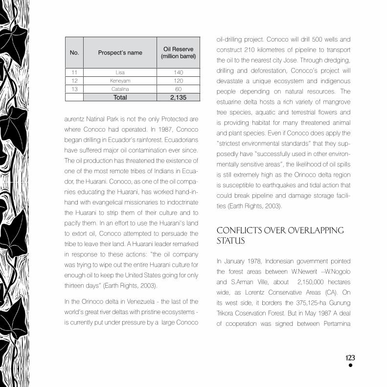
123
aurentz Natinal Park is not the only Protected are
where Conoco had operated. In �9�7, Conoco
began drilling in Ecuador’s rainforest. Ecuadorians
have suffered major oil contamination ever since.
The oil production has threatened the existence of
one of the most remote tribes of Indians in Ecua-
dor, the Huarani. Conoco, as one of the oil compa-
nies educating the Huarani, has worked hand-in-
hand with evangelical missionaries to indoctrinate
the Huarani to strip them of their culture and to
pacify them. In an effort to use the Huarani’s land
to extort oil, Conoco attempted to persuade the
tribe to leave their land. A Huarani leader remarked
in response to these actions: “the oil company
was trying to wipe out the entire Huarani culture for
enough oil to keep the United States going for only
thirteen days” (Earth Rights, 200�).
In the Orinoco delta in Venezuela - the last of the
world’s great river deltas with pristine ecosystems -
is currently put under pressure by a large Conoco
oil-drilling project. Conoco will drill 500 wells and
construct 2�0 kilometres of pipeline to transport
the oil to the nearest city Jose. Through dredging,
drilling and deforestation, Conoco’s project will
devastate a unique ecosystem and indigenous
people depending on natural resources. The
estuarine delta hosts a rich variety of mangrove
tree species, aquatic and terrestrial flowers and
is providing habitat for many threatened animal
and plant species. Even if Conoco does apply the
“strictest environmental standards” that they sup-
posedly have “successfully used in other environ-
mentally sensitive areas”, the likelihood of oil spills
is still extremely high as the Orinoco delta region
is susceptible to earthquakes and tidal action that
could break pipeline and damage storage facili-
ties (Earth Rights, 200�).
CONFLICTS OVER OVERLAPPING STATUS
In January �97�, Indonesian government pointed
the forest areas between W.Newerit --W.Nogolo
and S.Arman Ville, about 2,�50,000 hectares
wide, as Lorentz Conservative Areas (CA). On
its west side, it borders the �75,�25-ha Gunung
Trikora Coservation Forest. But in May �9�7 A deal
of cooperation was signed between Pertamina
No. Prospect’s nameOil Reserve
(million barrel)
�� Lisa �40�2 Keneyam �20�� Catalina 60
Total 2,135

12�
and Conoco Warim LTd for explorative activi-
ties in the 7,�-hectare Limited Productive Forest
whose permit was granted by Indonesia’s Di-
rectorate of Forestry Inventory and Usage Guid-
ance, valid for 6 months without any extension.
The overlapping status has then occured for
Lorentz National Park, Conoco Concession Area,
and Trikora Conservative Forest totaling 200,000
square hectares in width.
Ministry of Forestry admitted that the overlap has
occurred ever since the statuses were deter-
mined, but has never been exposed and paid at-
tention to. So when operational area of Conoco
Warim LTd. was determined, the problem of status
hadn’t come up yet.
In �997, Conoco Warim Ltd claimed that the Min-
istry of Forestry, without first consulted the par-
ties invloved, expanded the conservative area. It
resulted in an overlapping status of the �57,700
square hectare-area.
But Conoco Warim Ltd didn’t know it until �99�, im-
mediately suspending its explorative activities in the
area. Conoco should have known the problem since
it first operated in �9�7 because the legalization of
Lorentz Conservative Area was back then in �97�.
For this, in �999 Conoco Warim sent a protest let-
ter to Ministry of Agriculture and Forestry. Besides
Conoco, other parties asking for settlement of the
problem were Coordinating Minister of People’s
Welfare and Poverty Alleviation and Minister of Min-
ing and Energy.
Conoco Warim LTd. Still wants to continue its ac-
tivity within the National Park Area. The �57,700
square hectare-land that Conoco demands still
need to be researched and explored until 2002.
If the area won’t be economic for mining, then it
should be handed over to the government.
Government’s response
In response to Conoco’s demand, Bureau of Pla-
nology, Forestry and Agriculture on Sepetember 2�
�999 banned mining activity in Lorentz National Park.
As an alternative solution, government allowed di-
agonal drilling from outside of the national park.
This policy was supported by a note of Directorate
General of Nature Conservation and Protection
No. ��75/Dj-V/KK/99, issued on October 27 �999,
banning oil explorasion done by Conoco Warim
Ltd in the national park which was regarded as
world heritage.
Chief of Bureau of Forestry and Agriculture, on its
letter No. �579/VIII-POLA/�999, November �5,
handed over this issue to the Law and Organiza-
tion Bureau, Secretariat General of Forestry and

12�
and Agriculture. Consultation with Bureau of Law
and Organization on November �9, �999, resulted
in the following conclusion:
According to Regulation No. 5 �990 on Conserva-
tion of Nature, Biodiversity, and Ecosystem, con-
servative area within the national park is its main
zone and thus its utilization must be in line with
the forest’s function. The regulation is followed up
by Government instruction No. 6� �99� on Nature
Conservative Area and Nature Preservation Area.
In the third chapter of a joint letter between minister
of mining and energy and minster of forestry No.
969.K/05/MPE/�9�9; 429/kpts-II/�9�9, August 2�
�9�9, it stated that the location and expansion of
the National Park in which there have been oil and
gas exploration and exploitation are excluded from
the national park area.
The ninth chapter stated that to settle the problem of
overlapping status, a coordinatiing team was estab-
lished along with its operating team whose members
were recruited from the ministry of mining and energy
and ministry of forestry (SKB No. ��0�K/702/MMM.
PE/�99�-4�6/Kpts-II/�99�, �� December �996).
According to Law No.4 �999, verse ��, if the con-
servative area is to be utilized for nonforestry func-
tions such as mining activity that will expectedly
benefit the conserative area, national park and the
local people, then its function should be shifted into
Limited Production Forest (HPT). However, this had
yet to satisfy the local government of Irian Jaya.
The impacts of the oil activity to the national park,
such as:
• contamination,
• building of infrastructure,
• roads,
• spills,
• likings of oil,
• waste treatment (liquid, solid and gas)
Threats
Various threats to the national park have appeared
in the last twenty years. The area which became
national park in �999 was first disturbed when
Freepot tailing project entered its western area. The
activity caused broad ecological impacts to the
low land forests and mangrove along the Aijkwa
River. Others range from oil exploration plan in the
eastern part of the national park, destructive log-
ging and illegal logging on the 250-square hect-
are Wamena and Timika, to road constructions in
the area. Eaglewood hunting in the park continues
to destroy the local ecosystem. There have also

12�
been some catch-
ings of endangered
animals and plants
such as black-
headed parrot,
snakes, and some
wild orchids.
The absence of op-
erational units and the
park’s representatives that is di-
rectly in charge in its conservation and management.
Up to the present, the task is still handled by BKSDA
Papua I-II as a project with a fund allocation of only
�20 million Rupiah for its 2.5 million square-hect-
are area. So far the park hasn’t been appropriately
arranged, enabling irresponsible culprits to shift its
conservative functions. It’s strongly alleged that ille-
gal loggings have been committed, although not yet
identified due to wide area coverage and harsh geo-
graphical condition which makes their whereabouts
hard to detect. There hasn’t been zone divisions to
the national park area; nor area planning—a key to
zone divisions.
Area Conservation Director of Ministry of Forestry,
Ir Adi Susmianto, said that Council of Lorentz Na-
tional Park (Balai TNL) is not only determined by
Forestry Department, in this case Directorate of
Conservation of Natural Resources, but by State
Coordinating Minister because it deals with fund-
ing, work force, and provision of new facilities.
No. Threat Caused by Additional information
� Mining Freeport Ongoing
2 Mining Conoco Still disputed
� Area extension Local government Has been rampant in many areas
4 Forest destruction Other party Has been rampant in many areas
Threats to Lorentz

12�
BASIS FOR A MORATORIUM
The IUCN Amman Resolution calls to stop any min-
ing activity in protected areas under categories I - IV.
Later, in the lV IUCN World Park Congress in Durban,
there was a decision of some companies to stop
mining (for oil and minerals) in World Heritage Site.
In that Congress Adrian Phillips, World Commis-
sion on Protected Areas (WCPA), outlined chal-
lenges for the extractive industry, including com-
mitments: not to extract resources from PAs in
categories I-IV; not to seek to overturn national
legislation prohibiting mining activities in PAs; and
to accept the IUCN PA categorization.
In this line, the International Council of Mining and
Metals (ICMM) has recently pledged through a
dialogue with the IUCN to treat UNESCO World
Heritage sites as “no-go”.
In Indonesia the laws prohibits mining activities in
National Parks (Forestry Act No.4�/�999).
All Indonesian mining contracts state that the
company must obey Indonesian statutes and reg-
ulations including environmental protection laws.
These regulations and statutes may change from
time to time to adjust to the needs of the environ-
ment and social condition for the benefit of the In-
donesian people.
Indonesia has committed to the global conser-
vation of protected areas and natural biodiver-
sities by ratifying the Convention on Biological
Diversity(CBD) and agreed to the Statement of
Forest Principles. It is part of the United Nations
Forest Forum (UNFF).
Indonesian environment groups therefore insist that
Indonesia must honour and implement the interna-
tional agreements it has entered into. Meanwhile, they
demand that other countries respect laws made to
conserve and protect Indonesia’s environment.
At the local level, in �999 the legislative council of
Irian Jaya has asked US-based oil company PT
Conoco to stop its oil exploration in the Lorentz
National Park.
Provincial legislators are very concerned about
the oil exploration in the Lorentz National Park,
which has been named a world heritage site
by UNESCO,” the secretary of the assembly’s

12�
commission on human rights and environment,
said Anthonius’S Kelanangame. Anthonius said
Conoco’s activities would harm the flora and fauna
and melt the ice covering Mt Cartenz in the Puncak
Jaya district.
The Lorentz Park is located on �,450,000 hectares
of land owned by six districts Puncak Jaya, Nabire,
Mimika, Paniai, Jayawijaya and Merauke.
POSITION ON JATAM ON MINING IN PROTECTED AREAS
No Mining in Protected Areas
Deforestation in Indonesia has reached 2.4 mil-
lion hectares (�.2%) per year or approximately
�0 acres of rainforest a minute.
Act 4�/ �999 bans mining in protected forest
areas. Now, more than �50 mining companies
are encroaching on ��.4 million hectares of
protected area, including �.6� million hectares
of protected forests and 2.� million hectares of
conservation areas. The House of Representa-
tives (DPR) have remained silent in its decision
to grant mining licences in protected areas
The mining industry has a large area of opera-
tion covering 66.�9�.496 ha (more than �5% of
Indonesia’s land area) in 200�. Not satisfied, the
mining industry, with the assistance of several for-
eign Embassies, has been relentlessly lobbying
Indonesia to drop their environmental protection
laws and the ban on mining in protected area
BHP Billiton, Newcrest, Newmont, Placer Dome,
and Rio Tinto, and Inco are all members of
the International Council of Mining and Metals
(ICMM) who have committed to ‘respecting le-
gally recognized protected areas’, while at the
same time are hypocritically pressuring Indone-
sia to drop its ban on protected areas
The ICMM announced on August 20, through
its dialogue with the World Conservation Union
(IUCN), that it would treat all World Heritage Sites
as ‘no-go’. BHP Billiton, who was a participant

12�
in this dialogue continues its quest to mine on
Gag Island, of the Raja Empat archipelago in the
eastern part of Indonesia, despite the fact that
UNESCO has shortlisted it to be a natural World
Heritage Site
JATAM and the No Mining in Protected Areas
coalition calls on the parliament to stand firm in
its environmental standards and to save the for-
ests of Indonesia from the devastating effects of
mining by enforcing Act 4�/�999.
Call to Action on the IUCN and mining in protected areas
The IUCN World Parks Congress in Durban is an op-
portunity for civil society to have their voices heard
and to stand up for protected areas. The IUCN Am-
man Resolution that disallows mining in protected
areas MUST be implemented and strengthened.
The International Council of Mining and Metals
(ICMM) has recently pledged through a dialogue with
the IUCN to treat UNESCO World Heritage sites as
“no-go”. However, in Indonesia members of ICMM
are shamelessly pressuring the government to over-
turn prohibition against open-cut mining in protected
forests (Forestry Act
4�/�999). ICMM mem-
bers also hold leases
over national parks in In-
donesia, and their activities
threaten current and potential UNESCO World Heri-
tage Sites such as Lorenz National Park and the Raja
Ampats archipelago.
In Indonesia, a coalition of organizations and stu-
dents including WWF Indonesia, Walhi (Friends of
the Earth Indonesia), JATAM (Indonesian Mining
Advocacy Network) and the Mineral Policy Institute
have been working to stop the mining industry from
encroaching on Indonesia’s protected areas. Simi-
lar struggles are underway in Ghana, the Philippines,
Ecuador, Turkey, Tibet, Canada and Australia.
We must send the IUCN the message that de-
spite the ICMM rhetoric regarding biodiversity and
conservation, a dialogue with the global mining
industry is counterproductive as long as compa-
nies such as Rio Tinto, Newmont, Placer Dome,
Inco, and BHP Billiton continue to pressure gov-
ernments and communities to allow them to mine
in protected areas.

130
• ASEAN Heritage Park. Lorentz National Park.
www.arcbc.org.ph/AHP/Lorentz.html
• Harpswell Information. Conoco-Phillips En-
vironment Fact Sheet. The company. Cheryl
Golex No. 6.
• Indo Pacific Conservation Alliance. Maps of the
Greater Lorentz Lowlands, including Lorentz
National Park.
www.indopacific.org/maps.html
• Lorentz National Park – UNESCO World Heri-
tage Site.
http://whc.unesco.org/pg.cfm?cid=��&id_
site=955
• Mines & Communities. The case against Free-
port McMoran and Rio Tinto in West Papua.
www.minesandcommunities.org/Company/
freeport4.htm
• MiningWatch Canada. Mines Alert. July 200�.
SAVE INDONESIA’S PROTECTED FOREST AR-
EAS FROM MINING.
• Survival International. Tribes in Papua.
h t tp: / /surv iva l - in ternat iona l .org/s ights.
php?gallery_id=46
REFERENCES
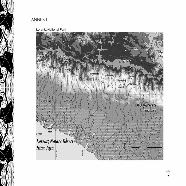
131
ANNEX 1
Lorentz National Park