Article: National Geographic Department -...
6
Lao People’s Democratic Republic 1 Article: National Geographic Department June 2016 A glimpse of the organization and its activities in brief By: Mr. Khachonesack DOUANGPHOUTHA 1. Introduction Lao People’s Democratic Republic or Laos is one of the fastest growing economies in the Asia Pacific Region with a GNI per capita of USD 1,600.00 in 2014. GDP growth averaged 7 percent over the last decade, with the increasing use of the country’s natural resources – mostly water, minerals and forests – contributing one third to the growth (THEWORLDBANK 2016). Laos is a landlocked nation that covers 236,800km 2 in the center of South East Asia. It is surrounded by Myanmar (235 km), Cambodia (541 km), China (423 km), Thailand (1,754 km), and Viet Nam (2,130 km) (Savada 1994). The topography of Laos is largely mountainous with elevation above 500 meters typically characterized by steep terrain, narrow river valleys, and low agricultural potential. This mountainous landscape extends across most of the north of the country, except the plain of Vientiane and the Plain of Jars in Xiengkhouang Province. 2. History of the National Geographic Department The mapping productions and aerial photography works in Laos have been divided into 4 different phases, namely: 1. Phase 1: Prior to 1955 - During the French Colony in the IX Century, the “Indochina Geographic Mapping Agency” was founded by France on the date of 01-Jul-1899 having a headquarters in Hanoi. - During the World War II (1939-1945), the Mapping Agency was moved to the city of Dalat, Lam Dong Province.
Transcript of Article: National Geographic Department -...

Lao People’s Democratic Republic
1
Article: National Geographic Department
June 2016
A glimpse of the organization and its activities in brief
By: Mr. Khachonesack DOUANGPHOUTHA
1. Introduction Lao People’s Democratic Republic or Laos is one of the fastest growing economies in the
Asia Pacific Region with a GNI per capita of USD 1,600.00 in 2014. GDP growth averaged 7
percent over the last decade, with the increasing use of the country’s natural resources –
mostly water, minerals and forests – contributing one third to the growth (THEWORLDBANK
2016).
Laos is a landlocked nation that covers 236,800km2 in the center of South East Asia. It is
surrounded by Myanmar (235 km), Cambodia (541 km), China (423 km), Thailand (1,754 km),
and Viet Nam (2,130 km) (Savada 1994). The topography of Laos is largely mountainous with
elevation above 500 meters typically characterized by steep terrain, narrow river valleys, and
low agricultural potential. This mountainous landscape extends across most of the north of the
country, except the plain of Vientiane and the Plain of Jars in Xiengkhouang Province.
2. History of the National Geographic Department The mapping productions and aerial photography works in Laos have been divided into
4 different phases, namely:
1. Phase 1: Prior to 1955
- During the French Colony in the IX Century, the “Indochina Geographic Mapping Agency” was
founded by France on the date of 01-Jul-1899 having a headquarters in Hanoi.
- During the World War II (1939-1945), the Mapping Agency was moved to the city of Dalat,
Lam Dong Province.

Lao People’s Democratic Republic
2
- On the date of 01-Apr-1955, the Royal Lao Mapping Organization was founded in 01.-Apr-
1955 in Vientiane having French engineers named: Monsieur. Jolly and Monsieur. Bourot
directed a “TOPO” Division. During this time, there were no Lao engineers.
Indochina National Geodetics Network prior to 1955 - Adapted from, (Sallat 2000)
2. Phase 2: From 1955-1975
- October 1956, there were 5 Lao engineers graduated from Phnom Penh, Cambodia (2
surveyors and 2 cartographers). Their main works of the TOPO Division include: providing
mapping services allocated by Indochina Geographic Mapping Agency such as: (coordinated and
elevation points during 1902-1939, the French has created Leveling I, II, III and IV; whereas in
Laos there was Leveling I with 47 points in total with unsystematic density of the coordinate
points). Leveling I, II, III were measured along the rivers by direct measurement; Whereas in the
plateau area, the elevation points were measured indirectly.
- In terms of the aerial photography, in 1954, the French conducted aerial photography work
along Laos-Viet Nam-China borders having the scale of 1 : 45 000, 12X18CM dimensions.
- In May 1959, the Royal Laos Government had changed to TOPO Division to be the ‘National
Geographic Department’ that comprised of cartography, printing, and survey divisions. The
department is headed by French graduated Mr. Chansamone VORAVONG as the first Director
General. Whereas most engineers were trained domestically and some were graduated from
France, Cambodia, and Thailand. Main works during this period include working alongside the
Americans in the survey, aerial photography, and map making

Lao People’s Democratic Republic
3
Sample aerial photography covering the whole country and maps created by the US Army used
in Indochina War having the scales of 1:50,000; 1:250,000 covering Indochina region.
Aerial Photography covering the whole country Scale 1:50,000 Topographic Map
3. Phase 3: From 1975-1995
- Lao People’s Democratic Republic (Lao PDR) was established on 02 December 1975
- After then, the Party and the Government had emphasized on the training of survey and mapping engineers. In 1990, there were 46 graduated engineers at the undergraduate, postgraduate, and doctorate levels from various Socialist countries. -The former Soviet Union (USSR) assisted the making of topographic map having the scales of 1:1,000,000; 1:500,000; 1:200,000; 1:100,000 and aerial photographic maps having the scale of 1:60,000 and scale 1:30,000 covering the whole country. - In addition, the topographic maps with the scale of 1:10,000 covering Xaybangfai Plateau,
Khammuan Province and 1:25,000 topographic maps covering Lek 9 Road, Savannakhet
Province were produced during this period.
Scale 1:100,000 Topographic Map National
Lao People’s Democratic Republic
4
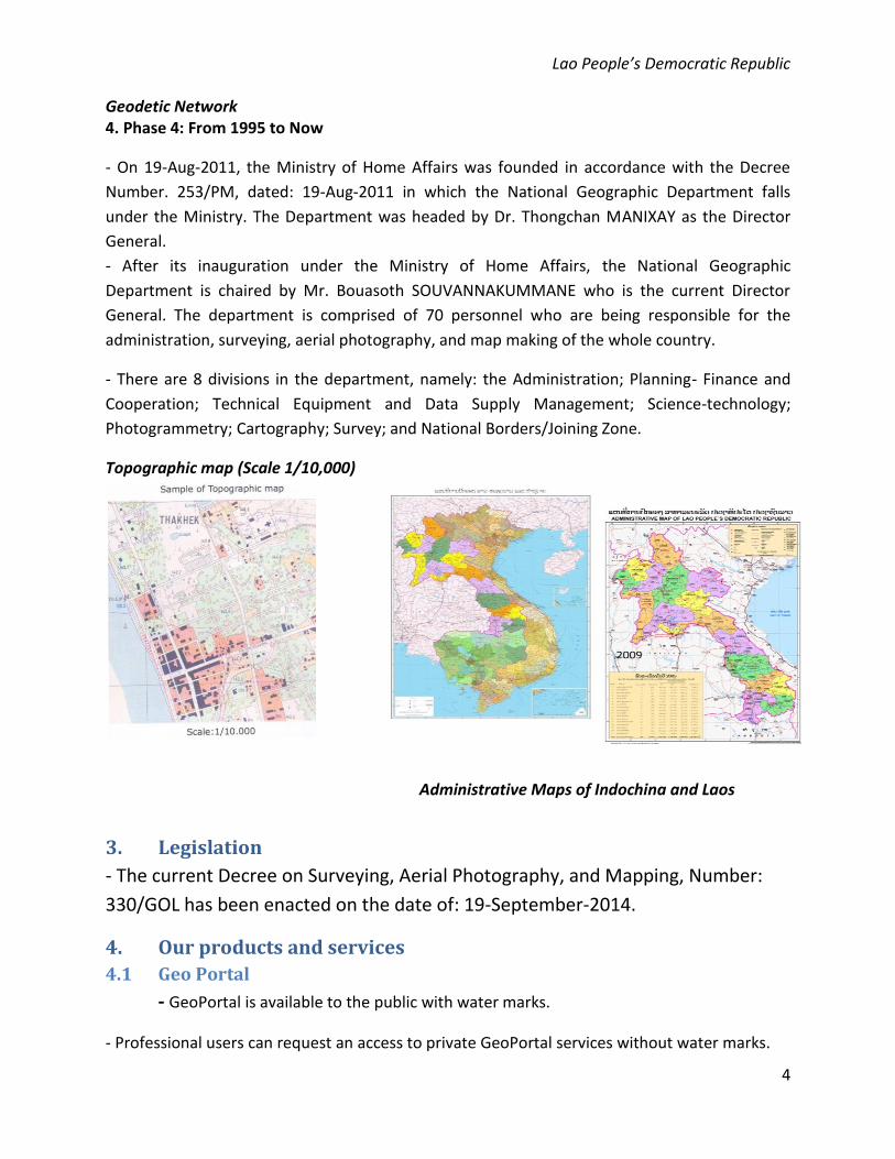
Geodetic Network 4. Phase 4: From 1995 to Now
- On 19-Aug-2011, the Ministry of Home Affairs was founded in accordance with the Decree
Number. 253/PM, dated: 19-Aug-2011 in which the National Geographic Department falls
under the Ministry. The Department was headed by Dr. Thongchan MANIXAY as the Director
General.
- After its inauguration under the Ministry of Home Affairs, the National Geographic
Department is chaired by Mr. Bouasoth SOUVANNAKUMMANE who is the current Director
General. The department is comprised of 70 personnel who are being responsible for the
administration, surveying, aerial photography, and map making of the whole country.
- There are 8 divisions in the department, namely: the Administration; Planning- Finance and
Cooperation; Technical Equipment and Data Supply Management; Science-technology;
Photogrammetry; Cartography; Survey; and National Borders/Joining Zone.
Topographic map (Scale 1/10,000)
Administrative Maps of Indochina and Laos
3. Legislation
- The current Decree on Surveying, Aerial Photography, and Mapping, Number:
330/GOL has been enacted on the date of: 19-September-2014.
4. Our products and services
4.1 Geo Portal
- GeoPortal is available to the public with water marks.
- Professional users can request an access to private GeoPortal services without water marks.

Lao People’s Democratic Republic
5
4.2 Aerial Photography
The orthophoto is an aerial photo, taken from an aircraft or satellite, geometrically
corrected (“orthoretified”) such that the scale is uniform. An orthophoto can be used to
measure true distance because it is an accurate representation’s of earth’s surface. It can
correctly determine locations, width, length, and area on real surface. Digital orthophotos are
currently used worldwide.
Orthophotos are created in two modes: RGB (red, green, and blue) and IR (infrared). Images can
be zoomed into clear accuracy up to 0.5meters above the surface. Coordinate systems are
based on two stsandards, the world coordinate system WGS84 and the local system, Lao 1997.
Orthophotos are scientifically important and necessary for users of all sectors. Using digital
orthophotos can help saving resources from fieldwork, especially in remote locations that are
difficult to reach. Customers can order aerial photographs of predefined area or make a request
for a customized aerial photograph for an area of your choosing by contacting NGD.
GeoPortal Interface on NGD website
4.3 Topographic maps
Topographic maps having the scale of 1:50,000 were used as base maps covering the
whole country. Apart from that, various purpose maps were produced namely: administration,
tourism, social-economics, world maps, atlases and among others.
Examples of topographic maps in various scales

Lao People’s Democratic Republic
6
5. About us and Contact
National Geographic Department (NGD) is the surveying, aerial photograpy and
mapping authority of Lao PDR under the supervision of the Ministry of Home Affairs and has
the authority to conduct research and establish policies regarding the surveying, aerial
photography, mapping for submission to the government for consideration, approval, and
official promulgation.
Our contact address:
National Geographic Department,
Ministry of Home Affairs
PO.Box 2159, Vientiane Capital
Lao PDR
Telephone: +856 21 214917
Fax: +856 21 214915
Email: [email protected]
Webpage: www.ngd.la
NGD’s location in Vientiane
References: Sallat, R. (2000). De L'Empire Colonial Aux Agences De L'I.G.N: 1940-1973. Paris, France, Institut Geographic National.
Savada, A. M. (1994). Laos: A Country Study. Washington DC, Washington: GPO for the Library of Congress.
THEWORLDBANK (2016). "Lao PDR Overview." Retrieved 20.05.2016, 2016, from http://www.worldbank.org/en/country/lao/overview.