ARKANSAS STATE WATER PLAN
29
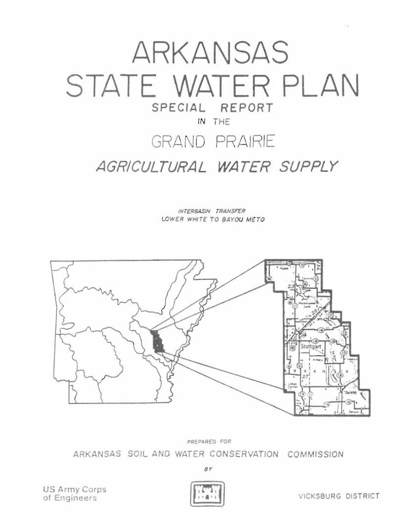
ARKANSAS STATE WATER PLAN SPECIAL REPORT IN THE GRANO PRAIRIE AGRICULTURAL WATER SUPPLY INrERBASIN rRANSFER LOWER WHITE TO BAYOU METO PREPARED FOR ARKANSAS SOIL AND WATER CONSERVATION COMMISSION US Army Corps of Engineers BY VICKSBURG DISTRICT
Transcript of ARKANSAS STATE WATER PLAN
ARKANSAS STATE WATER PLAN
SPECIAL REPORT IN THE
GRANO PRAIRIE
AGRICULTURAL WATER SUPPLY
INrERBASIN rRANSFER
LOWER WHITE TO BAYOU METO
PREPARED FOR
ARKANSAS SOIL AND WATER CONSERVATION COMMISSION
US Army Corps of Engineers
BY
VICKSBURG DISTRICT
IRRIGATION WATER SUPPLY STUDY EASTERN ~~ PRAIRIE REGION
Table of Contents
Item
INTRODUCTION
STUDY AUTHORITY
SCOPE OF THE STUDY
HISTORY
STUDY PARTICIPANTS AND COORDINATION
PRIOR STUDIES AND REPORTS
DESCRIPTION OF THE STUDY AREA
STUDY AREA
WATER QUALITY AND AVAILABILITY
TOPOGRAPHY
GEOLOGY
CLIMATOLOGY
Temperature
Precipitation
Evaporation
ENVIRONMENTAL CONSIDERATIONS
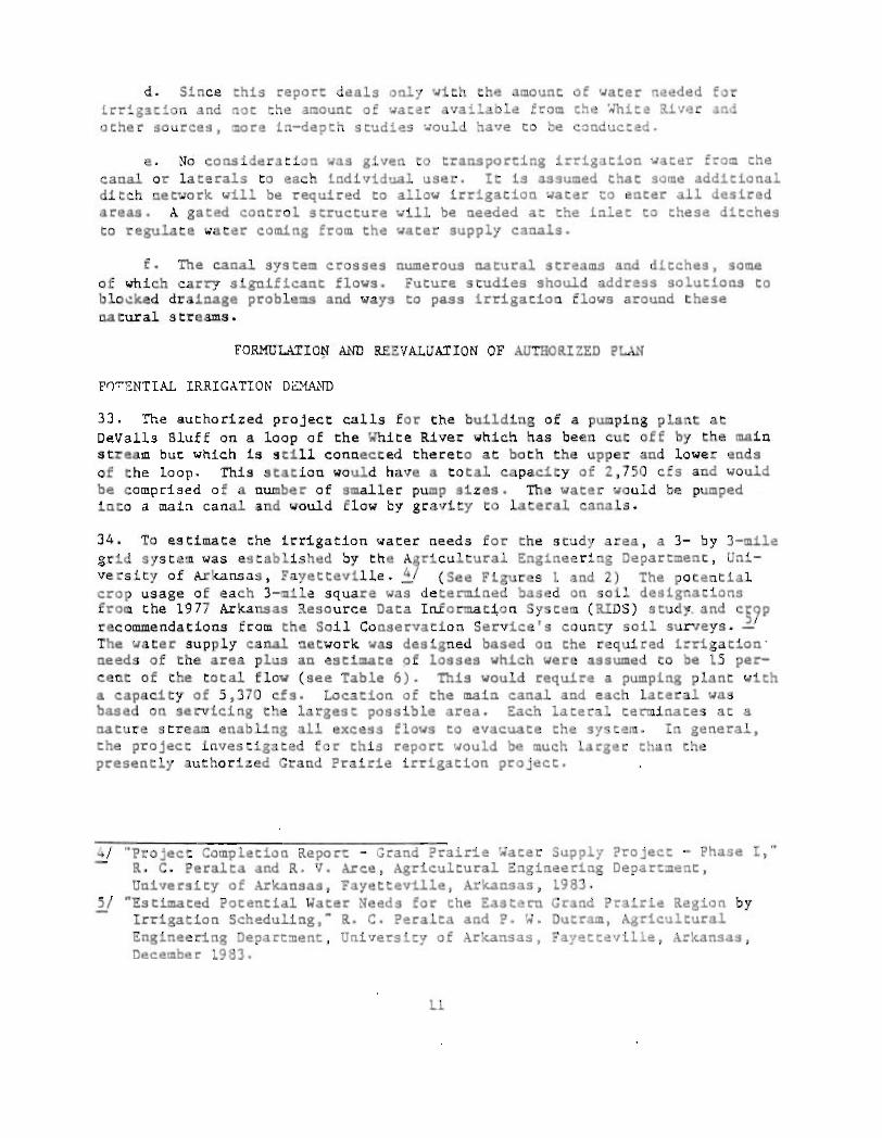
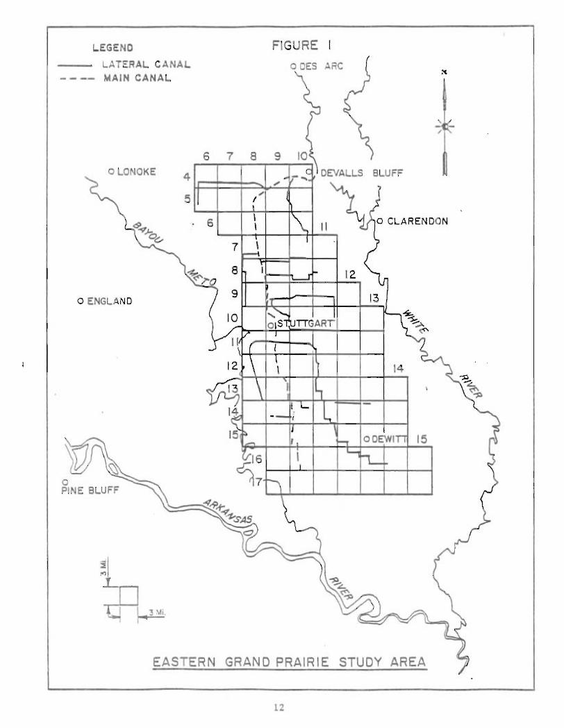
PROBLEM IDENTIFICATION, PLANNING OBJECTIVES AND CONSTRAINTS
PROBLEM IDENTIFICATION
PLANNING OBJECTIVES
1
1
1
1
1
2
2
4
4
4
7
7
7
T
8
8
8
9
9
10
Table of Contents (Cant)
Hem
PLANNING CONSTRAINTS
FORMULATION &~ REEVALUATION OF AUTHORIZED PLAN
POTENTIA!. IRRIGATION DEMAND
CANAL SIZE CALCULATIONS
COST DATA
CONCLUSION
RECOMMENDATIONS
No.
1
2
3
4
5
6
7
8
9
10
11
LIST OF TABLES
Title
REPORTS ON THE GRAND PRAIRIE REGION
INFORMATION ON SITE LOCATIONS
WATER QUALITY STANDARDS
SUMMARY OF RESULTS
WATER USE FOR ARKANSAS, PRAIRIE AND MONROE COUNTIES, 1981
IRRIGATION DEMANDS
GENERAL DESIGN INFORMATION ON CANAL SYSTEM
REQUIRED STRUCTURES AND PUMPS
REQUIRED L&~ ACREAGES, CHANNEL EXCAVATION, AND LEVEE FILL QUANTITIES
'.ATER SUPPLY DISTRICT NET RETURNS TO CROPLAND, GRAND PRAIRIE, ARKANSAS (PROJECTED WITH PROJECT)
COST OF PRODUCTION, GRAND PRAIRIE, ARKANSAS (WITH PROJECT)
11
10
11
11
14
18
23
23
3
4
5
6
10
14
15
16
17
19
20
No.
12
13
No.
1
2
Table of Content. (Cont)
LIST OF TABLES (Cont)
Title
WATER SUPPLY PROJECT NET RETURNS TO CROPLAND. GRAND PRAIRIE. ARKANSAS (PROJECTED WITHOUT PROJECT)
COST OF PRODUCTION. GRAND PRAIRIE. ARKANSAS (WITHOUT PROJECT)
LIST OF FIGURES
title
EASTERN GRAND . PRAIRIE StuDY AREA
MAIN AND LAXERAL CANALS SUPPLYING WATER TO EACH 3-MILE BY 3-MILE CELL
LIST OF PLAtES
No. title
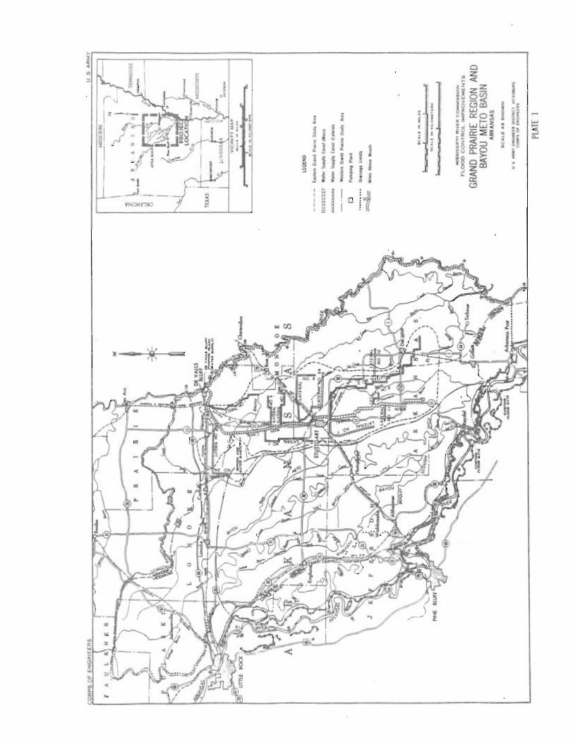
1 GRAND PRAIRIE AND BAYOU METO BASIN
2 EASTERN GRAND PRAIRIE
111
21
22
12
13
I~~IGATrON WATER SUPPLY STUDY ~ASTE~~ G~~ P~IRIE REGIO~
INTRODUCTION
1. The Eastern Grand Prairie area, as identified on Plate 1, is located in the east-central portion of Arkansas. The study area is primarily agricultural land and the principal crops grown are rice, soybeans, cotton, and wheat. Much of the area relies heavily on irrigation. The need to investigate using surface water to satisfy irrigation needs has resulted from diminishing ground-water sources. This study deals with the economic feasibility of pumping water from the White River for irrigation purposes in the Eastern Grand Prairie area. However, no investigations have been made as to the availability of White River water to meet the identified irrigation water needs.
STUDY AUTHORITY
2. This study is being performed in response to a request by the Arkansas Soil and Water Conservation Commission (ASWCC). The authority for the study is prOVided under Section 22 of Public Law 93-251, Planning Assistance to States Program, which authorizes the Chief of Engineers ( OCE) to cooperate with states in the preparation of comprehensive plans for the development, utilization, and conservation of the water and related land resources of drainage basins located within the boundaries of the states.
SCOPE OF THE STUDY
3. This study is being conducted to determine if the currently autQorized Corps of Engineers Grand Prairie project can economically meet the agricultural irrigation water needs in the various areas of the Grand Prairie region. More specifically, the study will identify those farmlands that call most economically be irrigated from waters of the White River.
,USTORY
4. Irrigation wate r ln the Grand Prairie area is obtained fr om shallow wells, deep wells, surface reservoirs, and natural streams. The greater part of the water required for irrigation is pumped from shallow wells. Under natural conditions water supplies are adequate for general agricultural production . Sources of water other than the Quaternary aquifer, where the ground water is found, must be expanded or water must be transported from some outside source l nto the area. Furt he~ore , t he importa t ion and control of supplemental a gr i cultural water appear necessary · t o r estore gr ound-wate r tables whi ch have progressively diminished due largely to heavy demands of ri ce cultivation . Since the Quaternary aquifer is not of uni f orm thicknes s, the l owering of t he underground water surface is much more s e rious in some locali t ies than in others.
5 . A project t o provide supp lemen t al wat er sup pl y t o t he eas tern port ion of t he Gr and Pr ai r ie r eglon was authorized by the Flood Con t r ol Act o e 195~ ,
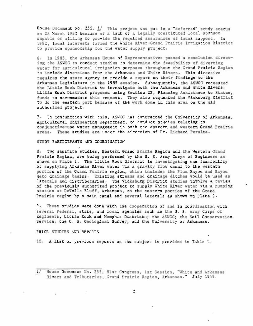
House Document No. 255. 1/ This project was put in a "deferred" study status on 28 March 1980 because-of a lack of a legally constituted local sponsor capable or willing to provide the required assurances of local support. In 1982, local interests formed the White River-Grand Prairie Irrigation District to provide sponsorship for the water supply project.
6. In 1983, the Arkansas House of Representatives passed a resolution directing the ASWCC to conduct studies to determine the feasibility of diverting water for agricultural irrigation purposes throughout the Grand Prairie Region to lnclude diversiona from the Arkansas and White Rivers. This directive requires the state agency to provide a report on their findings to the Arkansas Legislature in the 1985 session. Subsequently, the ASWCC requested the Little Rock District to investigate both the Arkansas and White Rivers. Little Rock District proposed using Section 22, Planning Assistance to States, funds to accommodate this request. They also requested the Vicksburg District to do the eastern part because of the work done in this area on the old authorized project.
7. In conjunction with this, ASWCC has contracted the University of Arkansas, Agricultural Engineering Department, to conduct studies relating to conjunctive-use water management in both the eastern and western Grand Prairie areas. These studies are under the direction of Dr. Richard Peralta.
STUDY PARTICIPANTS AND COORDINAtION
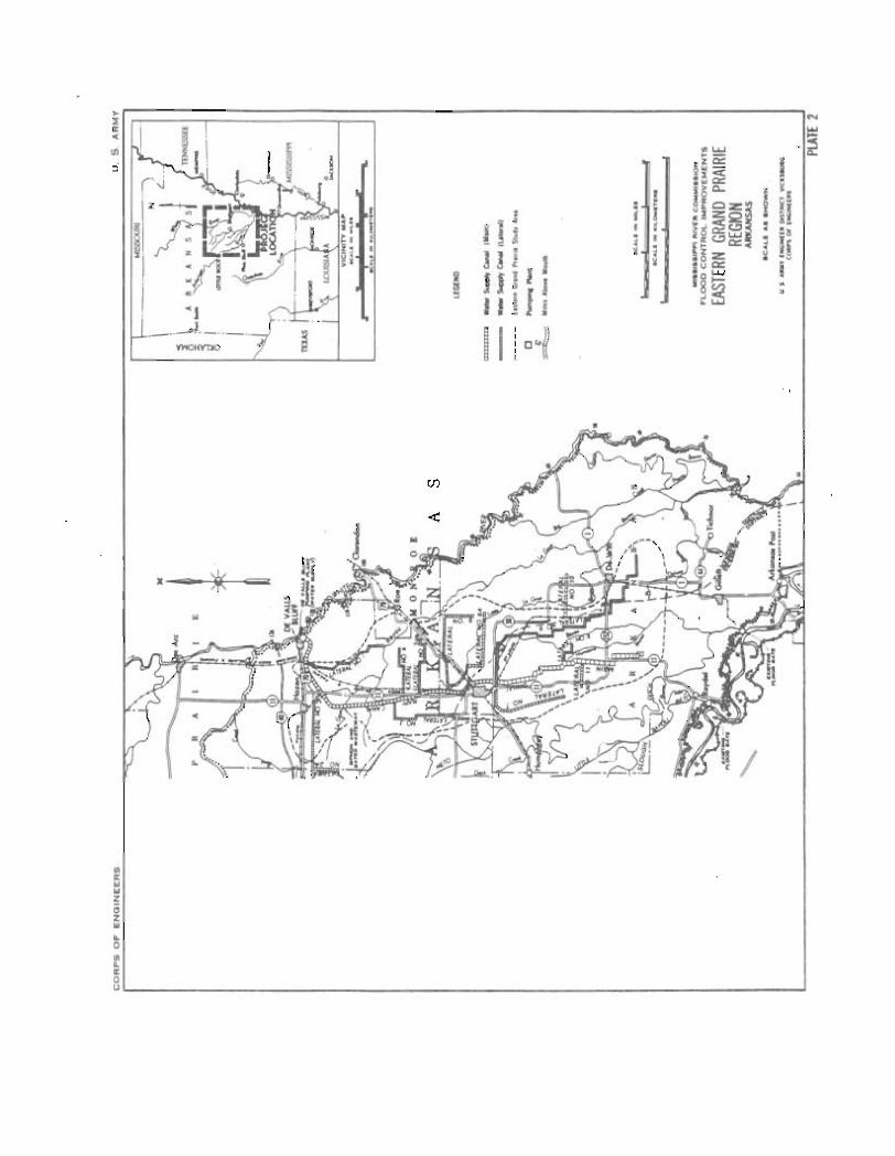
8. Two separate studies, Eastern Grand Prarie Region and the Western Grand Prairie Region, are being performed by the U. S. Army Corps of Engineers as shown on Plate 1. The Little Rock District is investigating the feasibility of supplying Arkansas River water via a gravity flow canal to the western po~ion of the Grand Prairie region, which includes the Plum Bayou and Bayou Meto drainage basins. Existing streams and · drainage ditches would be used as laterals and distributaries. The Vicksburg District studies involve a review of the previously authorized project to supply White River water via a pumping station at DeValls Bluff, Arkansas, to the eastern portion of the Grand Prairie region by a Main canal and several laterals a~ shown on Plate 2.
9. These studies were done with the cooperation of and in coordination with several Federal, state, and local agencies such as the U. S. Army Corps of Engineers, Little Rock and Memphis Districts; the ASWCC; the Soil Conservation Service; the U. S. Geological Survey; and the University of Arkansas.
PRIOR STUDIES AND REPORTS
10. A list of previqus reports on the subject is provided in Table 1.
1I House Document No. 255, 81st Congress, 1st Session, "White and Arkansas Rivers and Tributaries, Grand Prairie Region, Arkansas," July 1949.
2
TABLE 1 REPORTS ON !HE GRAND P~~IRIE REGION
1. "Renew of Reports, Grand Prairie Region and Bayou Meta Basin, Arkansas," Corps of Engineers, Vicksburg District, July 1948.
2. House Document No. 255, 81st Congress, 1st Session, "White and Arkansas Rivers and Tributaries, Grand Prairie Region, Arkansas," July 1949.
3. House Document No. 308, 88th Congress, 2d Session, ~ississippi River and Tributaries, Grand Prairie Region and Bayou Meto Basin, Arkansas," Annex P, October 1959.
4. "Hydrogeology of a Part of the Grand Prairie Region, Arkansas," U. S. Geological Survey Water Supply Paper 1615-B, Department of the Interior, WaShington, D. C., 1964.
5. "Lower Mississippi Region Comprehensive Study," Appendix F, Land Resources, 1974.
6. "Final Watershed Plan and Environmental Impact Statement, Plum Bayou Watershed, Flat Bayou Portion," U. S. Department of Agriculture, Soil Conservation Service, Little Rock, AR, 1981.
7. "Assessment of Arkansas River Water Quality and Potential Quantities Required for Irrigation in the Bayou Meto Basin," R. C. Peralta and P. W. Dutram, Agricultural Engineering Department, UniverSity of Arkansas; Fayetteville, AR, September 1982,'
8. "Potential Use of Arkansas River Water for Irrigation in the Plam Bayou Watershed." R. C. Peralta and P. W. Du t ram, Agricultural Engineering Department, University of Arkansas, Fayetteville, AR, February 1983.
9. "A Survey of Soils Irrigated with Arkansas River Water," J. T. Gilmour, H. D. Scott and R. E. Baser, Publication No. 96, Arkansas Water Resources Research Center, University of Arkansas, Fayetteville, AR, March 1983.
10. "Estimated Potential Water Needs for the Eastern Grand Prairie Region by Irrigation Scheduling," R. C. Peralta and P. W. Outram, Agricultural Engineering Department, University of Arkansas, Fayetteville, AR, December 1983.
11. "Using Target Levels to Develop a Sustained Yield Pumping Strategy in Arkansas, a Riparian Rights State," Richard C. Peralta and Ann W. Peralta, Appendix to the State Water Plan, May 1984.
12. "Paper No. 5021 - Optimizing Conjunctive Use Under Sustained Yield Constraints," R. C. Peralta, P. Killian, and W. D. Dixon, American Society of Agricultural Engineers, St. Joseph, Michigan, June 1984 .
3
DESCRIPTION OF THE STUDY AREA
11. This section of the "epo"t describes the study a"ea and the existing condi ti~ns .
STUDY AREA
12. The study area is located in the east-central portion of the State of Arkansas in Prairie, Monroe, and Arkansas Counties and is shown on Plate 2. For purposes of this repo"t it is bounded on the west by the Bayou Meto Basin, by the White River on the east, by Highway 70 to the north, and the Arkansas River on the south.
~ATER QUALITY AND AVAILABILITY
13. To evaluate and dete~ine the quality of the waters which may potentially be "equired for irrigation,. past and present water quality data were collected in the project area so a comparison could be made between the data collected and the established water quality criteria. The data were retrieved from the water quality control information system known as Storet .. A list of the stations sampled with the period of reco"d is contained in Table 2.
Site No.
28 29 30 31
!ABLE 2 INFORMATION ON SITE LOCATIONS
Description of Locations
~hite River at:
DeValls Bluff, AR Charendon, AR St. Charles, AR St. Charles, AR
Pe"iod of Record Beginning Date : Ending Date
74/04/03 71/10/21 77 /09/07 74/05/15
82/09/14 a/I 82/11/02 :! 82/08/23 a/I 83/09/06 :!
a/ Period of record is approximate.
14. For evaluating the suitability of water for irrigation, the following parameters were analyzed: conductance, sodium absorption ratio, chloride, sulfate, bicarbonate, alkalinity, pH, and heavy metal content. ~ater quali2¥ standards for each of these parameters were compiled by Peralta and Dutram--as ~hown in Table 3 with a summary of the results shown in Table 4. The following classifications were paraphrased from the Department of Agriculture Handbook 60:
l! R. C. Peralta and P. ~. Dutram, "Assessments of Arkansas River ~ater Quality and Potential Quantities Required for Irrigation in the Bayou Meto Basin," Agricultural Engineering Department, University of Arkansas, September 1982.
4
!ABLE 3 \lATER QUALITY STANDARDS
Parameter ,alIlll 07 Low Medium High Very High
Conductivity =.! (EC X 106) (micromhos/c:n)
< 250 250 - 750 750 - 2,250 > 2,250
Sodium adsorption ratio =.! (SAR)
Chloride b/ c/ (meg/ 1) - -(:ng/1)
Sulfate 5:J (meg/1) (mg/l)
Bicarbonates ~/ (HC3) (meg/1) (mg/1)
Alkal1n1 ty 2J (CAC03) (meg/1) (mg/1)
pli ~
lieavy Metals!! * (mg/l) .
< 6
< 5 < 177
< 10 < 480
< 3 < 183
< 3 < 150
< 8.5
< 10
6 - 10 10 - 18 > 18
5 - 10 > 10 177 - 355 > 355
10 - 20 > 20 480 - 961 > 961
> 3 > 183
> 3 > 150
) 8.5
> 10
* Al + As + Ba + Cd + Cr + Cu + Fe + Pb + Li + Hn + lig + Mo + Ni + Ag + U + Zn
~ O. S. Saiinloy Laboratory ,tarr, 1954. Dlagnos~s and lmprovemeno ot Saline and .Alkali Soils. USDA liandbook 60.
~ Ii. J. Harper and O. E. Stout, Salt Accumulation in Irrigation Soils.
c./
e/
f/
Oklahoma Agricultural Experiment Station, Bulletin No. B-360 (October 1950). Anon, Water Resources of California. California State Water Resources Board, Bulletin No.1 (1951). Personal communication, John T. Gilmour, University of Arkansas, Fayetteville, AR. J. E. McKee and H. W. Wolf (ed.) . Water Quality Criteria. California State Water Quality Control Board Publication No. 3-A (1963). R. F. Gondey, Developing Standards for the Protection of Groundwater. Journal A.W.W.A. 39, 1010 (1947).
5
Parameter
Conducti.,ity ~odium Adsorption Chloride Sulfate Bicarbonate Alkalinity pH Heavy metals
!ABLE 4 SUMMARY OF RESULTS
ioihite a.iver
low low low low low good good low
a. Low conductance or salinity water « 250 mmhos/cm, cl) can be used for irrigation with most crops on most soils.
b. Low sodium absorption ratio « 6) can be used for irrigation with most crops on most soils.
c. Low chlorides and sulfates are excellent to good and suitable for most plants and soils.
d. Low bicarbonate concentrations are considered good for irrigation purposes.
e. Alkalinity as CaC03 at concentrations less than 150 mg/1 is also considered good for irrigation purposes.
f. pH level between 6.0 and 8.5 is considered good to prevent harmful effects.
g. Heavy metal content of less than 10 mg/1 is considered satisfactory.
15. By comparing Tables 3 and 4, it can be seen that the White River water is nonoally sui table as a source for irrigation water. During a "dry year,'· below normal rainfall, salinity is often high during a large portion of the growing season. For example, in 1980 the state experienced its worst drought in 25 years, and the average conductivity values during this period jumped from low to medium.
16. In 1980 the ri.,erflow rates were extremely low and barely sufficient to maintain na.,igation on the ri.,er. Presently, the Memphis District, Corps of Engineers, is trying to maintain a 5-foot navigation channel in the White River along the reach including DeVa11s Bluff. During some years, the White River will provide adequate water for both navigational needs and for the maximum potential water demand scenario for irrigation, but in other years, inadequate runoff during the irrigation season will provide conflicts between irrigationa1 and navigational needs.
6
17. Seve~al studies ?~esentl, in the aceive status fo~ this area are the ~astern Arkansa s Region Comp~ehensive Study, the ~nite Rive~ ~avi~ation Project, and the White River, Arkansas and ~issouri, Autho~ized Report (the constructon of fou~ ~eservoirs for water supply and navigation).
TOPOGRAPHY
18. Somewhat more than one-half of the Grand Prairie region lies on a wide ridge , or terrace that was once a part of the flood plain of the Mississippi and Arkansas Rivers. This terrace extends in a southeasterly direction from the foothills of the Ozark Mountains for a distance of about 75 miles. It lies between the White River on the east and Bayou Meto on the west and is about 25 miles wide at the widest point. The terrace rises some 30 to 60 feet above the present flood plain of the White River and 10 to 30 feet above that of the Arkansas River and '~ayou Meto. The land surface is generally flat to undulating with an average elevation of about 235 feet, National Geodetic Vertical Datum (NGVD), in the northwest corner and sloping to about 180 feet, NGVD, at the southeastern extremity. Along the eastern boundary, tributary streams in their descent to the White River have eroded deep and narrow valleys. Streams to the west have far less slope and their valleys are not so pronounced. This terrace land, most of which is cleared, contains t he principal rice growing area of the Grand Prairie region.
GEOLOGY
19. The region is underlain by Pleistocene alluvium consisting of clay, sands, and gravels, which ~ange from 85 feet to nearly 200 feet in thickness. The materials a~e not uniformly deposited but, in general, vary from fine clays near the surface to wate~-bearing sands and gravels at the base . The water-bearing strata are the source of all the shallow-well ground supply of irrigation water in the Grand Prairie region. Prior to heavy pumping of water from these sands the water was confined under artesian pressure by the overlying clays. At present, a free water table exists over most of the region as a result of pumping in excess of the reCharge inflow. Above the Pleistocene sands lie thick strata of impervious clays, sands and silt, consisting partly of Recent alluvium and partly deposits of Pleistocene origin. The impervious clays (hard-pan) prevent inflow of surface water into the Pleistocene sands, except that a limited inflow along the White R1ve~ and perhaps along the lower reaches of Bayou Meto is indicated by records of water levels in the shallow wells. The Pleistocene formations rest unconformably on sediments of Tertiary age. Water-bearing horizons within the Te~tiary sediments are tapped by the deep wells at depths ranging from 450 to 1,200 feet.
CLIMATOLOGY
Temperature
20. The Grand Prairie region has a humid, subtropical climate with long, warm summers and short, moderately cold winters. The ~ean annual temperature is 61 degrees F at Stuttgart, with a mean of 76 degrees F for the ~onths of ~ay
7
through September. Snowfall is generally light and usually melts in a few days. !he ground seldom freezes to a depth greater than 2 inches.
?recicitation
21 . !he distribution of rainfall is fairly uniform over the region, with an average annual total of approximately 48.7 inches wit'h 17.9 inches occurring from May through September. A breakdown for the irrigation season is as follows:
May - 4.3 June - 3.2 July - 3.6 August September -
3.1 3.7
Evaporation
inches inches inches inches inches
22. An evaporation station has been maintained by the Rice Experiment Station near Stuttgart since 1929. !hese records indicate that the average annual evaporation from reservoirs and other water surfaces is about 37.4 inches with 23.3 inches occurring from May through September. It should be noted that the average evaporation exceeds the average rainfall for the months of May through September by 5.4 inches.
E~IRONMENTAL CONSIDERAIIONS 11
23. !he Grand Prairie region is unique within the State of Arkansas. Aside from its value to agriculture, the region contains natural lakes, bayous, manmade lakes, both large and small drainage ditches, irrigation reservoirs, fishing reservoirs, large acreages of water devoted to aquaculture,.large acreages of seasonally flooded reservoirs for duck hunting, and the large (37,000 acres) Bayou Meta Wildlife Management Area. Primary crops are rice, soybeans, wheat, and corn. Cotton is diminishing in importance as well as acreage. This diversity of land use provides diverse habitats for ~ll forms of wildlife, particularly waterfowl, shorebirds, fur bearers, and both sport and commercial species of fish. Endangered and threatened species such as the American alligator and the bald eagle, both with water-dependent life stages, do well in these habitats.
24. Terrestrial vegetation consists mainly of remnants of the once prevalent bottom-land hardwood forest of which only two large tracts, the Bayou Meta' Wildlife Management Area and the Wh,ite River National Wildlife Refuge, remain. Small remnants along some of the natural waterways have survived.
11 "Irrigation Water Supply Study, Western Grand Prairie," Corps of Engineers, Little Rock Oistrict, 1984.
8
~uch of the disturbed area is and numerous smaller shrubs. willows, bald cypress, tupelo vegatation.
now covered with willows, sweetgum, cottonwoods, The sloughs and shallow water bodies contai~ gum, buctonbush, and a variecy of aquacic
25. Fish life in che nacural waterway. includes catfish, largemouch bass, white crappie, several species of sunfish, bowfin, carp, buffalo, gar, and numerous species of native minnow •. Species propagated for financial gain in the aquaculture industry include catfish, golden shiner., fatheads, grass carp (white amur) , and some game fish such as crappie.
26. Game species of wildlife include squirrels, rabbits, deer, turkey, bobwhite quail, mourning dove, and fur-bearing species such as raccoon, mink, muskrat beaver, and oth~rs. Both sport and commercial waterfowl hunting is well established in this region, with the Stuttgart area touted as a duck hunting capitol. Frog hunting is a favorite seasonal sport.
27. Commercial fishing for catfish, buffalo, carp, and gar provides employment for individuals in the region. Most of this fishing is done on the Arkansas and White Rivers and their associated flood plain lakes.
28. There are many acres of wetlands, both natural and created, in the Grand Prairie region. The nature of the land use is such that minor fluctuations in acreage occur yearly, but the trend is toward a gradual increase in acreage.
29. Prime farmlands abound in the region. The only lands not considered prime are used for urban and built-up areas, are too steep to be considered prime, or experie~ce excessive floodi~g duri~g the growing season. Surface water quality is considered to be a problem in the region. Water qua~tities range from a deluge of water Ln the spri~g and early summer, most of which is highly turbid, to a scarcity of water in midsummer when water in the streams consists of water drained from rice fields. This "rice water" is clear and is of a higher quality than the waters in the early spring. Turbidity and sedimentation are problems associated with the current land uses.
PROBLEM IDENTIFICATION, PL&~NG OBJECTIVES, AND CONSTRAINTS
PROBLEM IDENTIFICATION
30. Over the past 20 years, total water use, particularly ground-water use, in eastern Arkansas has increased dramatically. The economy is based almost exclUSively on agriculture. Agricultural production in turn is dependent on the availability of large quantities of ground and surface water for irrigation of rice, wheat, and soybeans. This, coupled with withdrawals due to increases in population and greater recreational, industrial, and aquacultural water demands, has resulted in a decline of the region's water table. Water use for 1981 is shown in Table 5. Large quantities of water are pumped each year from the Mississippi River alluvial aquifer or quaternary aquifer to meet these needs. Withdrawals from the aquifer have increased from 1 million gallons per day (mgd) in 1960 to 4.6 mgd in 1980. Decli~ing water levels,
9
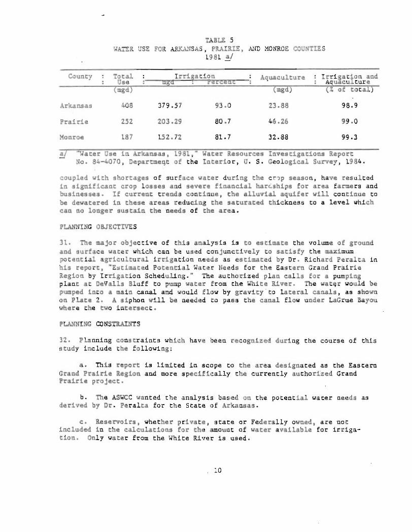
TABLE 5 WATER USE FOR ~~SAS, PRAIRIE, ~~D MONROE COUNTIES
1981 ~
County Irri ation Aquaculture Irrigation and A uaculture
'"8d) of total
Arkansas 408 379.57 93.0 23.88 98.9
Prairie 252 203.29 80.7 46.26 99.0
Monroe 187 152.72 81.7 32.88 99.3
'Vater Use in Ark.ansas, 1981," Water Resources Investigations Report No. 84-4070, Departmeqt of the Interior, U. S. Geological Survey, 1984.
coupled with shortages of surface water during the c~~p season, have resulted in significant crop losses and severe financial har,;ships for area farmers and businesses. If current trends continue, the alluvial aquifer will continue to be dewatered in these areas reducing the saturated thickness to a level which can no longer sustain the needs of the area.
PLANNING OBJECTIVES
31. The major objective of this analysis is to estimate the volume of ground and surface water which can be used conjunctively to satisfy the maximum potential agricultural irrigation needs as est.1mated by Dr. Richard Peralta in his report, "E~timated Potential Water Needs for the Eastern Grand Prairie Region by Irrigation Scheduling." The authorized plan calls for a pumping plant at DeValls Bluff to pump water from the White River. The wat~r would be pumped into a main canal and would flow by gravity ' to lateral canals, as shown on Plate 2. A siphon will be needed to pass the canal flow under LaGrue Bayou where the two intersect.
PLANNTNG CONSTRAINTS
32. Planning constraints which have been recognized during the course of this study include the following:
a. This report is limited in scope to the area designated as the Eastern Grand Prairie Region and more specifically the currently authorized Grand Prairie project.
b. The ASWCC wanted the analysis based on the potential water needs as derived by Or. Peralta for the State of Arkansas.
c. Reservoirs, whether private, state or Federally owned, are not included in the calculations for the amount of water available for irrigation. Only water from the White River is used.
, 10
d. Since this report deals only ~ith the amount of ~ater needed for irrigacion and not the amount of water available from the ·.'hite River and other sources, more in-depth studies would have to be conducted.
e. No consideration was given to transporting irrigation water from the canal or laterals to each individual user. It is assumed that SOme additional ditch network will be required to a110~ irrigation water to enter all desired areas. A gated control structure will be needed at the inlet to these ditches to regulate water coming from the water supply canals.
f. The canal system crosses numerous natural streams and ditches, some of which carry significant f10~s. Future studies should address solutions to b10~ked drainage problems and ways to pass irrigation flo~9 around these natural streams.
FORMULATIO~ AND REEVALUAIION OF AUTHORIZED PLAN
POTENTIAL IRRIGATION DEMAND
33. The authorized project calls for the building of a pumping plant at DeVal1s Bluff on a loop of the White River which has been cut off by the main stream but which is still connected thereto at both the upper and lower ends of the loop. This station would have a total capacity of 2,750 cfs and would be comprised of a number of smaller pump sizes. The ~ater would be pumped into a main canal and would flow by gravity to lateral canals.
34. To estimate the irrigation water needs for the study area, a 3- by 3-mile grid system was established by the Agricultural Engineering Department, University of Arkansas, Fayetteville. ~I (See Figures 1 and 2) The potential crop usage of each 3-mile square was determined based on soil designations from the 1977 Arkansas Resource Data Informat~on System (RIDS) study, and C§?p recommendations from the Soil Conservation Service's county soil surveys. -The water supply canal network was designed based on the required irrigation' needs of the area plus an estimate of losses which were assumed to be 15 percent of the total flow (see Table 6). This would require a pumping plant with a capacity of 5,370 cfs. Location of the main canal and each lateral was based on servicing the largest possible area. Each lateral terminates at a nature stream enabling all excess flows to evacuate the system. In general, the project investigated for this report would be much larger than the presently authorized Grand Prairie irrigation project.
!:J "Project CompletioCl Repor" - Grand Prairie Water Supply Project - Phase I," R. C. Peralta and R. V. Arce, Agricultural EngineeriClg Department, University of Arkansas, FayetteVille, Arkansas, 1983.
11 "Estimated Potential Water Needs for the Eastern Grand Prairie Region by Irrigation Scheduling," R. C. Peralta and P. W. Outram, Agricultural Engineering Department, University of Arkansas , Fayetteville, Arkansas, December 1983.
11
L.EGEND
L.ATERAL. CANAL
- - -- MAIN CANAL
o LONOKE 4
5
o ENGLAND
o PINE BLUFF
6 7 8
6
7
8
9
FIGURE I
o DES ARC
, /
9 DEVALL.S BLUFF
II o CLARENDON
12
13
TTGART
ODEWI 15
EASTERN GRAND PRAIRIE STUDY AREA
12
-
4
5
6
7
8
9
10
I II
12
13
14
15
16
17
6 7 8 9
NO . 2 NO . 2 NO . 2 MAIN
NO.2A NO.2A MAIN MAIN
NO.2 MAIN MAIN
t)O.3 NO.4
NO. 3 NO. 5
NO.3 NO. 6
NO . 3 MAIN
NO . 7 NO . 7
NO.7 MAIN
NO . 7 NO . 7
NO.II
NO .II
FIGURE :2
J 10 II
MAIN
NO.1
NO. 1
NO.4 NO. I
NO.5 NO.5
NO.6 NO.G
NO.GA NO.GA
NO.9 NO. 9
MAIN NO.9
NO. SA NO.9
MAIN NO.SA
MAIN NO. SA
MAIN NO. SA
MAIN
12 13 14 15
NO.G
NO .G NO . I
NO.GA NO . 1 \
NO.GA NO.1
NO.GA NO. 10 NO.1
NO.6A NO.GA NO . 1
NO .9 NO .9 NO I
NO. 9 NO .9 NO . I
NO . 9 NO . 9 NO . 1
MAIN AND LATERAL CANALS SUPPLYING WATER TO EACH 3 MILE SY :3 MILE CELL.
13
Name
Main Canal
Lateral Ut
Lateral 02
Lateral U2A
Lateral U3
Lateral 04
Lateral US La ceral d6
Latl!ral q6A
Lateral n Lateral USA
Lateral U9
Lateral HO
Lateral 1111
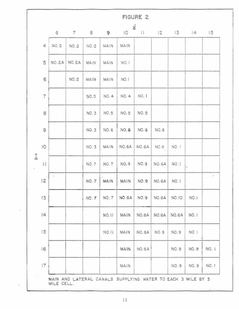
!ABLE 6 !RRIGATION DDiANDS a/
AccumulCive Demand Accumulacive
Loss ( cIs per Day)
Acre-Fee t per Week
64,845
4 , 198
4,035
1,877
3,753
1 , 591
3,O!6
12,966
8,302
5,276
4,753
10,223
1,025
2,370
c fs per Day
4,669
302
291
135
270
US
217
934
598
380
342
736
74
171
700
45
44
20
41
17
33
140
90
57
51
110
11
26
ACCUlllulat~ ve
(!oCal Demand cts per uay)
5,369
347
335
155
311
132
250
1,074
688
437
393
846
85
197
a/ Based on che peak ~eekly pocencial irrigation water needs from Dr. Peralta's report, "Estimated Potential Water Needs f or the Eastern Grand Prairie Region by Irrigation Scheduling."
CANAL SIZE CALCULATIONS
35. The canal system originates at the pumping plant and extends as a concrete flume for approximately 3,300 feet. Downstream from this point, it is a canal with a trapezoidal cross section. Through most of the system, levees are necessary to confine the flow. It is assumed that levee grades will provide a 2-foot freeboard over the maximum computed water surface. At the headworks, the canal has a capacity of 5,370 cfs. Table 7 contains the general design information on the water supply canals. Beginning at mile 3.55, laterals intercept the main canal as necessary to supply the area with requ1red·wat~. Renee, the size of the main canal and each lateral is reduced in size in accordance wich che decrease in flow as you descend downstream. Wa ter is de l ivered into each laceral by way of a gated control structure Co allow complece regulation for flows up to its design capacity. At the outlet to each lateral, a minimum gated control structure was designed to allow drainage of each lateral and to prevent any water in the laterals from entering the natural stream into which each one was tied, if desired. Where thl! water supply canals cross nacural streams, a siphon or some tYpl! of gated control structure wil l be needed. A lis t of the struccures and pumps required i s shown on Table 8.
14
TABLE 7 GE)1ERAL OESIG:1 I)ITOR:1ATION ON CA.NAL SYSTE:1
It em
General
Area to be served (acres) Maximum quantity of water available for
irrigation (cfs) Capacity of pumping plant (cfs)
Main Canal
Length (miles) Capacity at intake (cfs) Water surface at intak~ (feet, NGVD) Average slope (feet per mile) Freeboard (feet) Bottom width (feet) Mean velocity (feet per second) Concrete siphons (number) Drop structures (number) Gated controls to distribution system (number) Maximum depth of water (feet) Channel side slope Levee side slope Lands required (acres)
La terals
Length (miles) Capacity at. inlet (cfs) Control structures (number) Drop chutes (number) Pumps (number) Freeboard (feet) Bottom width (feet) Average slope (feet per mile) Maximum depth of water (feet) Channel side slope Levee side slope Lands required (acres)
L5
Amount
426,240+
4,670 5,370
45.8 5,370 226.5 0.22
2 L5 to 135
2.7 L 3
L2 L6.5
LV on 2H LV on 3H
1,228
iL4.8 85 to L,075
II 9 2 2
2 to 40 O.ll to 0.29 6.0 to 16.L
lV on 2H LV on 3H
1,565
~acne
Main Canal
Lateral Ql
Lateral 112
Lateral IU
Lateral U3
Lateral U4
Lateral il5
Lateral 06
Lateral 6A
Lateral U7
Lateral U8A
TABLE 8 REQUIRED STRUCTURES ~~ PU~S
:iileage
0.00 10.10
30.65 38.65 45.65 47.20
0.00 5.00 8.50 • 9.25
0.00 10.45
0.00 3.55
0.:)0 6.00 8.00
12.03
0.00 5.40
0.00 8.00
0.00 11.90
0.00 7.50
0.00 1.50 2.50
10.20
0.00 2.50 3.15
Pump Siphon
Type
Drop structure Drop structure Drop structure Gated box structure
Gated culvert Drop s truc ture Drop structure Gated culvert
Gated culvert Gated culvert
Gated culvel'"t Gated culvert
Gated Culvert Drop structure Drop structure Gated culvert
Gated culvert Gated culvert
Gated culvert Gated culvert
Gated box structure Gated culvert
Gated box structure Gated culvert
Gated box structure Drop structure Drop structure Gated culvert
Gated box structure Drop structure Gated culvert
16
Quantity and Size
One 5,370-cfs 10 feet high by
90 feet wide 7-foot drop 8-foot drop 8-foot drop One 6- by 6-foot
Two 60-inch Q!P
6-foot drop 6.5-foot drop One 60-inch OIP
Two 60-inch OIP One 60-inch OIP
Two 54-inch CMP One 42-inch CliP
Three 60-inch OIP 6.5-foot drop 6.5-foot drop One 60-inch CMP
One 54-inch CHP One 42-inch GliP
Three 66-inch CMP One 60-inch OIP
Three 8- by 8-foot Three 60-inch CMP
Two 7- by 8-foot Two 60-inch CMP
Two 6- by 6-foot 6.4-foot drop 6.4-foot drop One 60-inch CMP
Two 7- by 7-foot 7.5-foot drop One 60-inch CMP
~aCle
Lateral 119
Lateral U10
Lateral H1
:hleage
0.00 4.50
13.00 28.00
0.00
0.00
TABLE 8 (Cont)
Type
Gated box structure Drop structure Drop structure Gated culvert
Pump
Pump
Quantity and Size
Three 8- by 8-foot 4-foot drop 4-foot dro p Three 60-inch ~
One 85-ci s
One 200-cis
36. The laod required for the ~in canal aod each lateral was held to a minimum while channel grades were kept flat so that velocities would be low enough to prevent erosion from occurring. By combining various channel bottom widths and overbank flow Widths, canal thalwegs were then establis hed. Where needed, drop structures were located to keep the ground elevations above the channel thalwegs; Some assumptions lIIade and used include: Mannings' "0" value for channels was 0.035 and for overbank flow was 0.075; vertical distance between the upstrealll and dowustrealll thalwegs at any drop structure was lilllited to a lIIaximum of 8 feet; and the channel grade was kept around 0.2 foot per lIIile. Required land acreages, channel excavation, and levee fill quantities are shown 1n Table 9.
TABLE 9 REQUIRE!) LAND ACREAGES, Ca~~NEL EXCAVATION,
AND LEVEE FILL QUANTITIES
Required Channel Levee till '2./ Nue Land a/ Exca.vation
(acres) (cubic yards) (cubic yards)
Main Canal 1,228 8,681,189 2,829,584 Lateral III 113 637,087 187,790 Lateral .?2 110 1,562,596 22,525 Lateral lilA 32 477 ,890 0 Lateral 113 120 1,321,958 49,577 Lateral U4 55 123,554 125,029 Lateral US 92 145,660 231,601 Lateral U6 149 900,923 110,765 Lateral U6A 135 769,206 220,795 Lateral 117 156 534,677 723,375 Lateral liSA 55 49,862 211,334 Lateral 119 492 2,420,246 699,395 Lateral 1110 16 59,253 20,150 Lateral Ull 40 21,349 163,363
Total 2,793 17,705,450 5,595,283
al Between 1andside COdS of levees. b/ Assumes 2 feet of freeboard.
17
COST DATA
37. The following tabulation shows a summary of cOS ts and economic benefits for thi~ plan based on a ~5 perce nt contingency and the current Fede ral interest rate of 8-1/8 percent.
Summary of Costs
Required structures and pumps (Table 8) Contingency at +25%
Subtotal
Required land acreages, channel excavation, and levee fill quantities (Table 9)
Contingency at +25% Sub~tal
TOTAL COST
$78,617,580.00
19,654,420.00 $98,272,000.00
$21,667,371.00
5,416,829.00 $2) ,084 ,ZOO .00
$125,356,200.00
Summary of Economic Benefits
Weighted average productivity per acre (Future with project) (Tables 10 and 11)
Weighted average productivity per acre (Future without project) (Tables 12 and 13)
Weighted average benefit per acre
Annual benef i t 426,240 acres (Table 7) X $71.33 ~
Annual benefit/interest rate -Annual cost - over 10-year period -Benefit-cost ratio - 2.43
$156.41 2.1
85.08
$ 71.33
$ 30,403,699.20
$363,029,244.20
$ 12,535,620.00
2.1 Based on with-project benefits calculated from distribution of crops found in "Estimated PotenCial Water Needs for the Eastern Grand Prairie Region by Irrigation Scheduling,· by R. C. Peralta and P. W. Outram, December 1983.
18
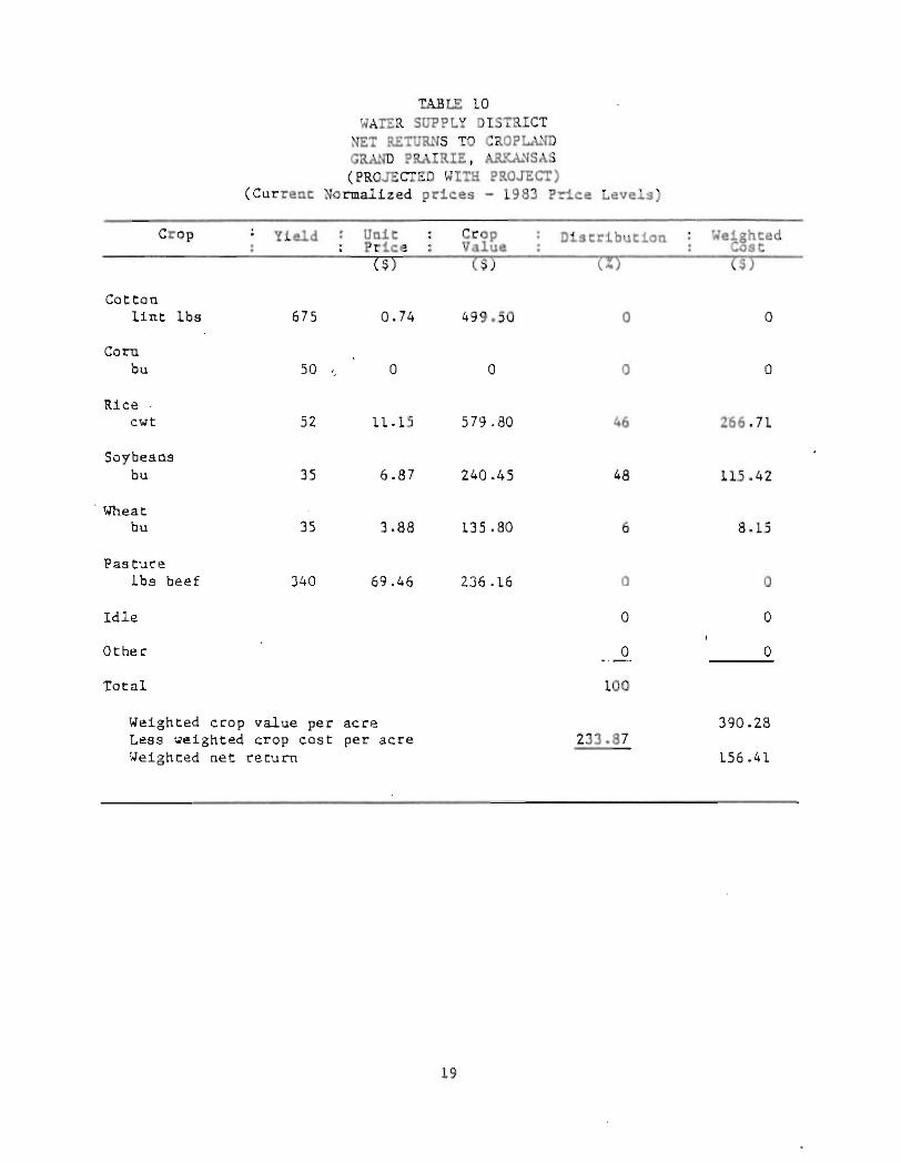
TAllLE 10 WATER SUPPLY DISTRICT
NET RETURNS TO CROP~~ GRAND PRAIRIE, ~~~SAS (PROJECTED WIT!! nOJECT)
(Curreot Normalized prices - 1983 Price Levels)
Crop Yield Uoit Crop Distribution Price Value
($) ($) CI)
Cotton lint lbe 675 0.74 499.50 a
Corn bu 50 '. 0 a 0
Rice ' cwt 52 11.15 579.80 46
Soybeans bu 35 6.87 240.45 48
, Wheat bu 35 3.88 135.80 6
Pasture 1bs beef 340 69.46 236.16 0
Idle a
Other 0
Total 100
Weighted crop value per acre Less weighted crop cost per acre 233.87 ~eighted net return
19
Weighted Cost
a
a
2'66.71
115.42
8.15
o
o
o
390.28
156.41
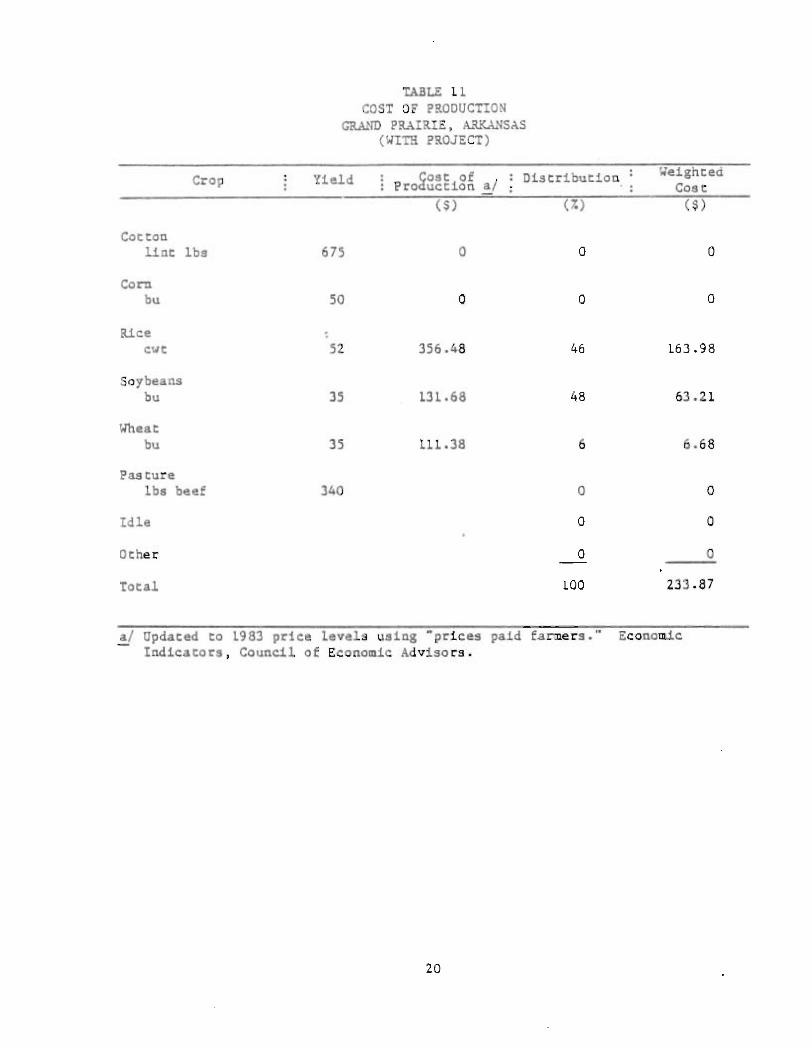
TABLE 11 COST OF PRODUCTION
GRAND PRAIRIE, ARKANSAS (WITH PROJECT)
Crop Yield Cost of Production a/ Distribution Weighted
Case
Cotton lint lbs 675 0
Corn bu 50 a
Rice cwt 52 356.48
Soybeans bu 35 131.68
\/heat bu 35 111.38
Pasture lb. beef 340
Idle
Other
Total
~ Updated to 1983 price levels using ·prices Indicators, Council of EconOMic Advisors.
20
(7. )
a a
a a
46 163.98
48 63.21
6 6.68
a a
a a
a a
100 233.87
paid fal"ll1ers.·· Economic
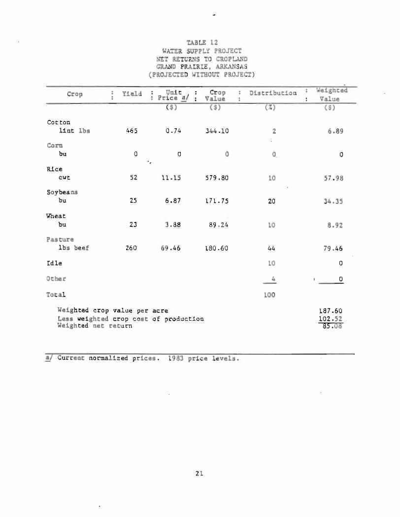
TABLE 12 WATER SUPPL:( PROJECT
NET RETURNS TO CROPLAND GRAND PRAIRIE. ARKANSAS
(PROJECTED WITHOUT PROJECT)
Crop Yield Unit Crop Distribution Weighted Price al Value Value
(~ ) ($) (%) ($)
Cot ton lint Ibs 465 0.74 344.10 2 6.89
Corn bu 0 0 0 O. 0
Rice cwt 52 11.15 579.80 10 57.98
Soybeans bu 25 6.87 171.75 20 34.35
Wheat bu 23 3.88 89.24 10 8.92
Pasture lbs beef 260 69.46 180.60 44 79.46
Idle 10 0
Other 4 0
Total 100
Weighted crop value per acre 187.60 Less weighted crop cost of production 102.52 Weighted net return 85.08
al Current normalized prices. 1983 price levels.
21
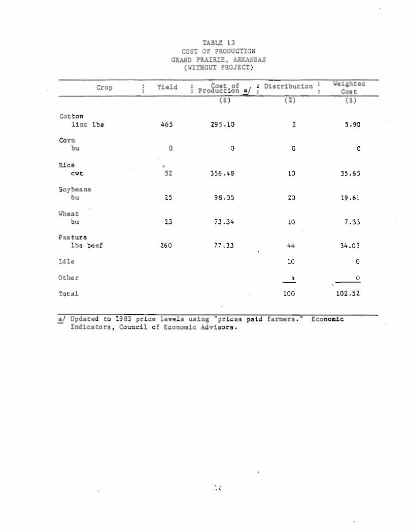
TABLE 13 COST OF PRODUCTION
GRAND PRAIRIE, ~~SAS (WITHOUT PROJECT)
Crop Yield ~oat of af ; Distribution Weighted Pro uc.tion Cost
($) (%) ($)
Cotton lint Ibs 465 295.10 2 5.90
Corn bu 0 0 0 0
Rice --cwt 52 356.48 10 35.65
Soybeans bu 25 98.05 20 19.61
Wheat bu 23 73 .34 10 7.33 '
Pasture Ibs beef 260 77 .33 44 34.03
Idle 10 0
Other 4 0
Total 100 102.52
!y Updated to 1983 price levels using "prices paid farmers." Economic Indicators, Council of Econo~ic Advisors.
22
CONCLUSION
38. This report ~as based on Dr. Peralta's study on the Eastern Grand Prairie Region using the irrigation needs for the maximum potential ~ater demand scenario. Available ~ater sources such as private- and government-owned reservoirs, and private wells were not taken into consideration. The maximum need of 5,370 cfs a~ DeValls Bluff pumping plant could be reduced when these are taken into account.
39. Based on the benefit-cost ratio, the project is economically feasible. Further studies will be needed to determine whether or not the project can be successfully implemented.
40. In general, the project investigated for this report would be much larger than the presently authorized Grand Prairie irrigation project; i.e., pump plant size and channel si~e. This would in all likelihood require additional Congressional authorization for Federal construction.
RECOMMENDATIONS
41. It is recommended that any future studies made be coordinated with the persons and agencies working on the following: White River Navigation Project; the White River, Arkansas and . Missouri, Authorized Report; and the Eastern Arkansas Region Comprehensive Study.
23
<1 __ _ ,.-Ill. _ .. _ _ .
'thOHV'TXI
; .,
I, . , rl! , , i ;
i ,
> • ~ < \I)
~
• ~ • • z 0; z • .. o • • ~
• • <)
__ __ .-01 __ ____ -
'tl'<OI<YllO
.. - j ; i HI i' n I I ~ l ~ HIP !! ~ i
II i C~~
.~
" -rc:: I .-.< .. c:: Q, ! U~Z~
,
i ~ i-, -J ! 'ZQ •
I i~~~i • !-• " • • Ii p" c:::. • ; • ~ .~ Z ~ -u
• U c:: i i§ ~ . <~ •
o uL-__________________________________________________________ ~