Architecture and Prototypical Realization of NFC-based … · 2017-07-14 · Architecture and...
17
Architecture and Prototypical Realization of NFC-based Indoor Positioning with Android and Google Maps Joachim Fabini, Reinhard Russ, and Lukas Wallentin Institute of Telecommunications, Vienna University of Technology Gusshausstrasse 25/E389, 1040 Vienna, Austria Email: [email protected], [email protected], [email protected] Abstract. Fundamental to location-based services is accurate position- ing information which is commonly acquired using one or several of three main technologies: Global Positioning System (GPS), cellular network information (Cell-ID, OTDOA), or wireless network (WLAN). However, indoor location technologies are still in an infancy stage, main reason be- ing the lack of adequate location sensors and indoor maps. In this paper we present concepts, architecture and implementation of a novel RFID- based indoor positioning prototype which uses standard functionality of today’s NFC-equipped smartphones. The proposed solution aggregates and processes available location sources, including RFID/NFC, Blue- tooth, WLAN and GPS. It uses a web services infrastructure including server-based algorithms and own indoor maps to separate positioning algorithms from location sensors and to compute accurate, floor-specific position. Feasibility of the theoretical concept is demonstrated using a fully functional prototype which has been implemented as Mobile App for Android-based Google Nexus Series smartphones. It seamlessly inte- grates indoor positioning with Google Maps outdoor positioning, offering highly accurate indoor positioning as pre-requisite of future advanced in- door location-based services. Main application of the indoor location pro- totype is the development and testing of novel location algorithms which aggregate and combine distinct location sensors and sources. However, the system can be easily extended and deployed to offer, e.g., accurate customer indoor door-to-door navigation in large shopping malls. 1 Introduction Outdoor maps and location-based services (LBS) have become ubiquitous, being an important support for everyday life. Web portals or Mobile Apps offer a wide variety of free services ranging from restaurant guides to route planners which all rely on location services and maps of three major online map providers: Google Maps 1 and OpenStreetMap 2 supporting device-independent APIs and 1 Google Maps: http://maps.google.com/ 2 OpenStreetMap: http://www.openstreetmap.org/
Transcript of Architecture and Prototypical Realization of NFC-based … · 2017-07-14 · Architecture and...

Architecture and Prototypical Realization ofNFC-based Indoor Positioning with Android and
Google Maps
Joachim Fabini, Reinhard Russ, and Lukas Wallentin
Institute of Telecommunications, Vienna University of TechnologyGusshausstrasse 25/E389, 1040 Vienna, Austria
Email: [email protected], [email protected], [email protected]
Abstract. Fundamental to location-based services is accurate position-ing information which is commonly acquired using one or several of threemain technologies: Global Positioning System (GPS), cellular networkinformation (Cell-ID, OTDOA), or wireless network (WLAN). However,indoor location technologies are still in an infancy stage, main reason be-ing the lack of adequate location sensors and indoor maps. In this paperwe present concepts, architecture and implementation of a novel RFID-based indoor positioning prototype which uses standard functionality oftoday’s NFC-equipped smartphones. The proposed solution aggregatesand processes available location sources, including RFID/NFC, Blue-tooth, WLAN and GPS. It uses a web services infrastructure includingserver-based algorithms and own indoor maps to separate positioningalgorithms from location sensors and to compute accurate, floor-specificposition. Feasibility of the theoretical concept is demonstrated using afully functional prototype which has been implemented as Mobile Appfor Android-based Google Nexus Series smartphones. It seamlessly inte-grates indoor positioning with Google Maps outdoor positioning, offeringhighly accurate indoor positioning as pre-requisite of future advanced in-door location-based services. Main application of the indoor location pro-totype is the development and testing of novel location algorithms whichaggregate and combine distinct location sensors and sources. However,the system can be easily extended and deployed to offer, e.g., accuratecustomer indoor door-to-door navigation in large shopping malls.
1 Introduction
Outdoor maps and location-based services (LBS) have become ubiquitous, beingan important support for everyday life. Web portals or Mobile Apps offer a widevariety of free services ranging from restaurant guides to route planners whichall rely on location services and maps of three major online map providers:Google Maps1 and OpenStreetMap2 supporting device-independent APIs and
1 Google Maps: http://maps.google.com/2 OpenStreetMap: http://www.openstreetmap.org/

web-browser access, and Apple supporting own devices only. LBS like point-to-point navigation applications are supported by availability of accurate, affordableGPS receivers, either as stand-alone units or components of smartphones ornavigation devices. Mobile phones improve location accuracy by aggregating andconsistency-checking GPS data with 2G or 3G cell information, and, optionallyby integrating data of visible wireless LAN (WLAN) access points.
1.1 Problem Statement and Motivation
When LBS are used in buildings the drawbacks and limitations of technologieslike GPS [13], Galileo [2] or other cellular network based systems come into ef-fect. Their signals do not propagate adequately into buildings, raising the needfor additional low-range positioning technologies to support accurate indoor po-sitioning at room or floor level. Possible fields of application include for instanceairports, shopping malls, retail stores, social networks applications, Internet ofthings, smart cities or ambient intelligence for indoor robotics.
This paper presents concepts and methodologies on how to integrate short-range NFC devices with other location sources such to enable indoor locationat room or floor level. It is important to note that from a jurisdictional pointof view, indoor location, as well as the use of indoor maps, might be subjectto increased privacy requirements when compared to outdoor location. Theseaspects are of fundamental relevance for the future deployment and success ofindoor location-based services but left explicitly outside of this paper’s focus,which is strictly on architectural and technical aspects of indoor positioning.
The proposed indoor location prototype, in the following referred to as IIPS(Institute of Telecommunications Indoor Positioning System) focuses on usabil-ity and integration with existing standards. On this purpose, the client softwareextends the Google Maps API3 for seamless integration of detailed indoor maps,offering an application which runs on today’s Android Smartphones and usestheir existing location sensors. However, main aim of the prototype is to buildan experimental platform for positioning algorithm testing. As will be detailedin the following sections, the IIPS client is primarily used as a location sensorand display device, while the IIPS server aggregates client-sent location sensorinformation with global knowledge using experimental algorithms in order tocompute the IIPS client’s position in near-real time. One main requirement forthe prototype architecture was, therefore, to outsource all algorithms to the IIPSserver, facilitating runtime-modification and -testing of positioning algorithms.
1.2 Related Work
The vast majority of contributions for indoor positioning systems aim at replac-ing Global Positioning System (GPS) [13], Global Orbiting Navigation SatelliteSystem (GLONASS) and Galileo [2] by alternative (non-standardized) indoorpositioning techniques. Most popular fields of applications are indoor tracking
3 Google Maps: https://developers.google.com/maps/documentation/android/

systems for hospitals, applications for tourists or mobile robot navigation [8] [15].In July 2013, Google has started indoor positioning services for selected areasand buildings4.
These location systems rely on technologies like Wireless Local Area Net-work (WLAN) [20], Bluetooth [4], Radio-frequency identification (RFID) [11],ultra-wide band (UWB), ZigBee or sensor networks as infrastructure for local-ization [15]. Alternative approaches use infrared communication, ultra-sound,vision-based or audible sound [8] for indoor location. The authors of [3] improveaccuracy of a WiFi indoor positioning system using Bluetooth dongles, but donot integrate RFID Tags. Another related reference [9] integrates Google Mapsand Android into an indoor positioning system, tracking indoor objects usingZigBee module locations and outdoor objects using GPS.
NFC-based indoor positioning and navigation systems targeting smartphoneshave been proposed by [19], [10], and [5]. The indoor navigation application pre-sented in [19] uses NFC tags positioned at landmark locations for indoor routing.The client app downloads custom maps from a server and processes location in-formation, computing navigation routes. This concept is extended in [10] byadding QR code support for localization and implementing a series of dedicatednavigation services (e.g., finding the nearest toilet or car park). However, thesepublications use special-purpose maps which do not integrate with existing out-door mapping services. We consider aggregation of various location sources asproposed by [5] to be required for determining an approximative location whilenot in the proximity of NFC tags or QR codes.
Beyond technological infrastructure, indoor positioning requires sophisticatedpositioning techniques and algorithms. Liu [15] and Al Nuaimi [1] categorizeavailable techniques and algorithms into three groups: geometric approaches,scene analysis and proximity. Gu [8] mentions vision analysis as an additionalgroup.
Main contribution of this paper is on one hand a generic architecture whichseamlessly integrates indoor and outdoor location in an Android applicationbased on Google Maps. The proposed IIPS architecture supports required in-door maps to be provided and location information processed by third-partyservice providers, offering interesting business opportunities. On the other hand,the presented server-based architecture aggregates data originated by a widevariety of location sensor technologies. Capturing of sensor-technology-specificproperties supports algorithms in sensor prioritization, evenutally increasing ac-curacy and offering reliable mechanisms for location consistency verification.
We argue that appropriate handling of complex, heterogeneous location sen-sor information, which mobile devices can acquire, requires a huge amount ofcontext information for accurate interpretation. Examples include, but are notlimited to, WLAN access point positions, signal strength, and building-specificsignal propagation models. This is why IIPS prefers server-based processing ofclient-provided raw sensor information over client-only-processing or providingcontext information to mobile devices. Finally, server-based operation supports
4 Google Indoor Maps: http://maps.google.com/help/maps/indoormaps/

run-time modification and fine-tuning of algorithms. This is a central require-ment for the main IIPS functionality of being a versatile location algorithmdevelopment and testing system.
1.3 Structure of this Document
Section 2 reviews basics of location-based services with particular focus on tech-nologies and concepts used in the remainder of this work. Section 3 introducesthe generic IIPS indoor positioning system concept, followed by discussion andevaluation in section 4. Section 5 concludes the document with a summary andoutlook on future work.
2 Location Basics
This section presents a short review and discussion of location and positioningalgorithms used for implementing the IIPS prototype.
2.1 Geometric algorithms
Geometric approaches like trilateration and triangulation estimate positionsbased on geometric properties of triangles. Trilateration uses measures of dis-tance for calculating the estimated position [1], whereas triangulation estimatesthe current position by means of angles to reference points [6]. In case of signal-based positioning the challenging task with weighted trilateration is to developadequate signal propagation models which convert received signal strength (RSS)into a distance measurement. In particular, positioning accuracy in indoor envi-ronments is biased to a large extent by interference of non-line-of-sight (NLOS)and multipath signals.
According to [8] and [15] triangulation can be subdivided into the RSS-based method, the round-trip time of flight method (RTOF), the angle of arrivalmethod (AOA), the time of arrival method (TOA) and the time difference ofarrival method (TDOA).
The proposed IIPS prototype is designed as a location algorithm experimen-tation platform, therefore not being bound to a specific location algorithm. Somepositioning methodologies are not well suited for indoor positioning, for instanceTOA, which relies on cellular GSM network timing. In its basic configuration,the prototype aggregates a series of algorithms, one of which is the centroidalgorithm, denoting a polygon’s geometrical center. When compared to triangu-lation, the centroid algorithm does not necessarily require three reference points,at the cost of being less accurate. A RSS-value threshold, as introduced in thispaper, can support in avoiding deflected results.
2.2 Scene Analysis
A second category of location techniques is (radio-frequency based) scene analy-sis. These algorithms require an extensive calibration phase, consisting of a priori

acquisition of signal fingerprints for a specific scene. The actual position is esti-mated later on by comparing the current signal fingerprint with database-storedreference fingerprints. In literature these two phases are referenced as online andoffline phase.
Liu [15] sub-categorizes fingerprint-based positioning algorithms using pat-tern recognition techniques, mentioning k-nearest-neighbor (kNN), neural net-works, support vector machine (SVM) and smallest M-vertex polygon (SMP).Mathematically advanced and formal fingerprinting methods as well as filter-ing approaches (e.g. Bayesian filtering) are described in [12]. Main drawbacksof scene analysis algorithms include the requirement for extensive calibrationmeasurements and a significant computational effort at runtime for accurate fin-gerprint acquisition. The use of scene algorithms for accurate positioning in widearea indoor LBS is therefore preferred for highly populated key regions.
Still, the precision of accurately calibrated fingerprinting algorithms is ade-quate, which is why the prototype uses this technique as part of the aggregatedindoor positioning.
2.3 Proximity Algorithms
The most important category with respect to NFC-based positioning is the oneof proximity algorithms [6], sometime also referenced as ID positioning algo-rithms. These algorithms provide symbolic relative location information, ref-erencing some known location positions or areas identified by specific targetobjects. When such a tracked target object is captured, then the algorithm esti-mates the current position at this known location position or area. If more thanone target object is detected, then the location area with the strongest receivedsignal is chosen. The IIPS prototype uses proximity algorithms for location de-vices with small ranges (Bluetooth dongles and RFID-Tags).
2.4 Location Sensor Technologies
Data for positioning can be extracted either from an existing infrastructure orfrom special devices dedicated for indoor positioning. The huge benefit of reusingexisting infrastructures is the cost factor. For indoor positioning the infrastruc-ture must consist of local-range technologies such as Wireless Local Area Net-work (WLAN) [20], Bluetooth [4], Radio-frequency identification (RFID) [11] orNear Field Communication (NFC) [17] devices.
Wireless Local Area Network: WLAN (WiFi) [20] is based on IEEE 802.11standards. The original 802.11 standard has been extended to 802.11b respec-tively to 802.11b/g which, at the time of writing, is the most widely used WLANstandard. The data rate of IEEE 802.11b/g is up to 11/54 Mbit/s in the 2.4GHzband within a range of 50-100 m.
A reference point for positioning (an access point) is identified by its uniqueMAC address, while the SSID (Service Set Identifier) of a WLAN network is

freely selectable. The WLAN radio signal can be used for location estimationby exploiting the RSS-value. The WLAN interface of the Samsung Nexus S5
smartphone supports IEEE 802.11b (11 Mbit/s), IEEE 802.11g (54 Mbit/s) andIEEE 802.11n (300 Mbit/s).
Bluetooth: The IIPS uses Bluetooth [4] as a short-range technology for posi-tioning. Bluetooth is based on WiFi 802.11 WLAN and operates on the samefrequency band as WLAN [4]. The range of Bluetooth varies from 5m (class 3)to 100m (class 1), publications typically approximating the range of Bluetoothwith 10 meters. Bluetooth dongle signals support the IIPS in refining accuracyof the WLAN-acquired location.
Radio Frequency Identification (RFID): An improvement of IIPS overpublished indoor location systems is the aggregation of Radio-frequency identi-fication (RFID) [11] based position with other location technologies. The approx-imate range of RFID is shorter than the range of Bluetooth. Existing publica-tions differentiate between four different types of RFID-Tags: Active tags, passivetags, semi-passive tags and semi-active tags. The range of passive tags, whichgain their electric power through an inductive field, varies from a few centimetersto one meter, while the range of active tags, which are powered by batteries, canachieve ranges up to 15 meters [11]. Frequencies of RFID-Tags can be brokeninto four ranges as well: Low Frequency (9-135 KHz), High Frequency (13.56MHz), Ultra High Frequency (0.3-1.2 GHz) and Microwave (2.45-5.8 GHz) [11].The range depends on both, the type of the RFID-Tag and the used frequency.
Near Field Communication (NFC): Near Field Communication (NFC) [17]is an implementation of RFID technology. It operates at 13.56 MHz, has anoperation range of a few centimeters and can transfer data up to 424 kbit/s.The NFC communication consists of an active NFC device (NFC reader), whichstarts the communication, and a target like a (passive) RFID-Tag or anotherNFC device. NFC supports three distinct operating modes: Card EmulationMode, Reader/Writer Mode and Peer-to-Peer Mode [18]. Two NFC-devices sharemessages through the NFC Data Exchange Format (NDEF) Exchange Protocol.The NFC technology is at the center of the presented IIPS prototype, inexpensiveRFID-Tags for positioning being read by the smartphone-integrated NFC reader.
2.5 Discussion
Selection of the most appropriate location technologies/infrastructures, locationtechniques and location algorithms depends on the specific use case. The major-ity of referenced publications rely on WiFi fingerprinting. Triangulation performsbetter in line-of-sight environments, but fails in typically indoor WLAN infras-tructures [16]. Besides adequate precision of fingerprinting, the low cost factor
5 Nexus S: http://www.samsung.com/us/mobile/cell-phones/GT-I9020FSTTMB

(obtained by reusing WiFi infrastructure) and simplicity are reasons for prefer-ring this algorithm. Advanced units like IMU (Inertial measurement unit) canbeneficially support indoor positioning systems. In [14] such an approach basedon accelerometer, magnetometer and gyroscope is implemented on an iPhone4S.
Ideally, sensors for indoor location sources should be integrated with a portablemobile device such as a smartphone. For accurate location display, public maps asOpenStreetMap or Google Maps should be integrated in a standardized way withprivacy-sensitive, potentially access-restricted third-party indoor map reposito-ries. Although portable computers such as tablets or laptops are an option forindoor location terminals, we consider them as being inadequate in most usecases.
Concluding the discussion on location algorithms and technologies we con-sider the basic concept of the IIPS prototype to be promising, aggregating lo-cation information of an existing infrastructure (WLAN) with low cost locationtechnologies (Bluetooth and RFID) by means of well-established algorithms ascentroid and fingerprinting. All required client sensors are already integratedinto a Google Nexus S reference mobile.
3 Concepts and Architecture
The proposed IIPS prototype depends on three distinct stages in its work flow:calibration, positioning, and visualization. These modules and their main taskswill be presented in the following.
3.1 Calibration
The initial stage of indoor positioning is calibration as shown in the left partof fig. 1. During this stage location data is acquired and stored in a database,such that the positioning systems learns geographic coordinates and identitiesof available location devices. Location devices in this context are devices whichcan be used for indoor position estimation, e.g. WLAN access points, Bluetoothdongles, RFID tags, etc. Alternatively the system must learn fingerprints for thecovered indoor area, which insert one RSS-snapshot of all visible location devicesat specific geographic coordinates into the database.
It is important to note that the calibration process is executed only once bythe maintainer or operator, when enabling a specific building or floor for indoornavigation. Re-calibration is required after substantial infrastructure changeslike, e.g., re-location of referenced location sources like WLAN access points.
3.2 Positioning
Following calibration, the positioning system is ready for operation. The reviewof positioning algorithms in section 2 has pointed out that these algorithms typ-ically operate on input sets of fingerprints or/and location devices. Accordinglythe calibration phase provides all of the required reference data for operation.

Fig. 1. Calibration and positioning
The positioning module, visible at the bottom of fig. 1, computes an esti-mate of the target’s position by comparing its scan result against the calibrationdata collection stored in the calibration database using one or several locationalgorithms.
Beyond all position techniques and algorithms, the positioning phase relieson a hierarchical rule concept, which is referenced as QoPos (Quality of Position-ing) in this paper. Distinct location sources have different accuracy, reliability,and robustness, depending on location source technology and configuration. TheIIPS currently uses the simplest of all metrics, the inverse of the sensor’s max-imum access range. Main assumption is that the smaller the distance betweentarget and location source is, the higher is the accuracy and reliability and thelower the likelihood of impairments. The corresponding algorithm is depicted inpseudocode in algorithm 1.1.
Depending on the positioning algorithm, only the scan result’s subset withhighest QoPos might be used for computing the current location. All other scanresults can be ignored or, alternatively, used for plausibility and consistencyverifications.
3.3 Visualization
The final step of the proposed workflow is visualization, during which the resultobtained during the positioning phase, i.e. the server algorithm’s output on thetarget’s estimated position, is displayed on the target device. The methodologyto be used for visualization depends mainly on the target platform. Visualizationoptions can range from displaying some numerical coordinates on a small textdisplay, up to complex scenarios like, e.g., displaying accurate indoor maps andmarking the exact indoor location and potential uncertainty areas on these maps.The latter solution has been adopted for the IIPS prototype that displays the

Input: Positioning info acquired (scan result) by the target deviceOutput: Host accurate target device position
1 maximumQuality ←− 0;2 maximumQualitySet←− ∅;3 foreach qualityOfCurrentLocationDevice ∈ (Scan result) do4 if qualityOfCurrentLocationDevice > maximumQuality then5 maximumQuality ←− qualityOfCurrentLocationDevice;6 maximumQualitySet←− currentLocationDevice;
7 end8 if qualityOfCurrentLocationDevice == maximumQuality then9 maximumQualitySet←−
maximumQualitySet ∩ currentLocationDevice;
10 end
11 end12 estimatePosition(maximumQualitySet);13 doPlausibilityCheck(Scan result);
Algorithm 1.1: Scan result filter QoPos
estimated position on indoor maps seamlessly integrated with the Google MapsAPI on a Samsung Nexus S smartphone.
3.4 Architecture
Fig. 2 depicts the IIPS prototype’s modular structure and components. The sys-tem consists of three main components: the Android-based client, the TomCat6
server, and the PostgreSQL-Server7. The client is an Android Application (app)executed on a Samsung Nexus S mobile phone, responsible for scanning locationsensor information, triggering position estimation by the server and displayingthe current position using Google Maps. In addition, the client supports a cal-ibration mode, implemented by the so-called Learning Manager, which can beused to acquire data for the server’s reference location database.
The TomCat server is responsible for deploying the networked server soft-ware. One main server requirement is the ability to plug in and test a widevariety of location algorithms which estimate client position based on their re-ported location sensor information. It is important to note that the server itselfcurrently does not access actively any kind of location sensors. Instead, serverpositioning relies exclusively on location data received during the calibrationphase and client-provided sensor information.
For calibration purposes, the server acquires location point and fingerprintdata through a RESTful Web Service using Jeresy8 as JAX-RS implementation.A SOAP Web Service can be used as an alternative. However, SOAP involveshigher communication overhead and at the time of writing the Android SDK9
6 Apache Tomcat: http://tomcat.apache.org/7 PostgreSQL: http://www.postgresql.org/8 Jeresy: http://jersey.java.net/9 Android SDK: http://developer.android.com/sdk/index.html

Fig. 2. System architecture
does not include a SOAP library10. From a design perspective, the server relieson the Data Access Object pattern11 as a means for database access abstrac-tion. The server implementation uses Hibernate12 as persistence framework andGuice13 as dependency injection framework. Reference location data is storedpersistently in the PostgresSQL database.
During operation, the server returns the estimated position of clients througha RESTful Web Service. Clients receive geographical coordinates of their esti-mated position from the server and the client app displays this position on anindividual indoor map, which is integrated on top of Google Maps.
The HTTP client shown in the upper right part of fig. 2 is intended as alogging front-end to facilitate development and debugging. Examples of serverinformation available through the HTTP interface includes, e.g., the list of allcurrently registered Android-Clients and selected sensor data.
4 Evaluation and Measurement Results
As mentioned earlier, main purpose of the IIPS prototype is to serve as a loca-tion algorithm experimentation and development platform. Although position-ing algorithms like fingerprinting or centroid have been implemented for testingpurposes, the focus of evaluations is on the client’s and system’s responsivenessrather than on location accuracy. In the following first measurement results will
10 ksoap2-android (http://code.google.com/p/ksoap2-android) is a SOAP library forthe Android platform, but is not part of the Android SDK.
11 Dao: http://www.oracle.com/technetwork/java/dataaccessobject-138824.html12 Hibernate: http://www.hibernate.org/13 Guice: http://code.google.com/p/google-guice/
be presented, some of them with potential impact on future architectures ofindoor location systems.
4.1 Functionality Evaluation
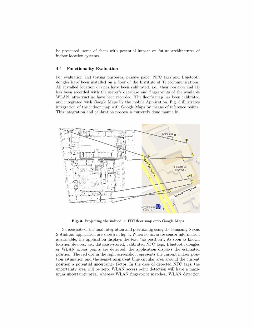
For evaluation and testing purposes, passive paper NFC tags and Bluetoothdongles have been installed on a floor of the Institute of Telecommunications.All installed location devices have been calibrated, i.e., their position and IDhas been recorded with the server’s database and fingerprints of the availableWLAN infrastructure have been recorded. The floor’s map has been calibratedand integrated with Google Maps by the mobile Application. Fig. 3 illustratesintegration of the indoor map with Google Maps by means of reference points.This integration and calibration process is currently done manually.
Fig. 3. Projecting the individual ITC floor map onto Google Maps
Screenshots of the final integration and positioning using the Samsung NexusS Android application are shown in fig. 4. When no accurate sensor informationis available, the application displays the text “no position”. As soon as knownlocation devices, i.e., database-stored, calibrated NFC tags, Bluetooth donglesor WLAN access points are detected, the application displays the estimatedposition. The red dot in the right screenshot represents the current indoor posi-tion estimation and the semi-transparent blue circular area around the currentposition a potential uncertainty factor. In the case of detected NFC tags, theuncertainty area will be zero. WLAN access point detection will have a maxi-mum uncertainty area, whereas WLAN fingerprint matches, WLAN detection

with RSSI weighting or Bluetooth dongles will benefit from intermediate ac-curacies. A functional version of server-based algorithms which support thesefunctionalities is operational, main focus for the future being development ofnovel algorithms to improve indoor position and uncertainty factor estimation.
Fig. 4. Screenshot of Indoor Positioning Application
One main limiting factor in position estimation has turned out to be locationsensor quality, i.e., the accuracy, robustness, consistency and timing of locationsensor data and RSSI measurements that Android and the Samsung Nexus Smobile device can provide to applications. NFC detection works flawless but op-timizations are required to improve accuracy, stability and representativeness ofWLAN RRSI level measurements, in particular during calibration phase. This iswhy the IIPS Android application has been extended to offer user-configurablemenu entries for measurement averaging and aging algorithms. E.g., one effec-tive solution to significantly improve WLAN RSSI measurement quality is tocompute a weighted sum of the current RSSI result and a series of previous(recent) measurement results. The count and respective weighting of historicmeasurements to be considered is a matter of algorithm optimization.
Timing and delay of location sensor data is mainly influenced by the end-user device’s technology and system architecture. Measurement results providedin the following are supposed to give an order of magnitude on these limitingfactors.

4.2 Round-trip Delay Measurements
(a) HSPA (3G) delay histogram (b) WLAN delay histogram
Fig. 5. Request-reply round-trip delay (terminal posts sensor data and server replieswith estimated position) using 3G HSPA and WLAN data networks, statistics basedon 1000 measurement samples
Depending on networks available at the testing location and the access tech-nology selected by the Samsung Nexus S mobile phone, the indoor location clientapplication exchanges data with the IIPS server either using 3G High SpeedPacket Access (HSPA) or WLAN technology. The histograms in fig. 5, relyingon 1000 measurements, respectively, depict round-trip delay for positioning re-quests as measured by the Android application. When comparing the medianresponse delay value, the measured delay for 802.11g WLAN access is 220 msand only slightly below the 3G delay of 260 ms. Moreover, the 95-percentileof WLAN delay amounts to 430 ms, which is considerably higher than the 3G95-percentile of 340 ms. The WLAN infrastructure was the official Vienna Uni-versity of Technology WLAN network at vacation time, results being confirmedby measurements with other, isolated WLAN access points. Recently publishedHSPA delay measurement results [7] consider round-trip delays of 150 ms forpackets below 400 bytes and HSPA devices supporting 7.2 Mbit/s to be typical.A realistic conclusion with respect to the round-trip-delay measurement resultsis, therefore, that significant part of the delay is spent in application space. Anadditional factor for the high WLAN delay could be interference with the WLANscanning procedure, which is used for detecting adjacent WLAN access points.
4.3 Scan Delay
An important metric for indoor location performance is the delay between trig-gering a specific location sensor scan and availability of the corresponding sensorinformation. Figures for NFC tag reading delay can not be provided because ofthe interrupt-type Android implementation of NFC detection. When the NXPPN65 NFC reader on the Samsung Nexus S detects a NFC tag, Android gen-erates a signal (Intent) to which applications can subscribe. However, practical

experience with the Samsung Nexus S has confirmed the NFC reader to operatehighly reliable and with low delay.
The Bluetooth results in fig. 6 illustrate that Bluetooth scan is subject to adeterministic delay of more than 10 seconds and low delay variation. This valueis independent on the kind of Internet data connectivity – 3G HSPA or WLAN– which is used for exchanging data with the IIPS server.
(a) Bluetooth scan delay (HSPA 3G) (b) Bluetooth scan delay (WLAN)
Fig. 6. Scan duration of potential Bluetooth location sources while terminal is con-nected via 3G HSPA or WLAN network. Statistics based on 100 measurement samples
The time required by the Samsung Nexus S to scan for available WLANs asshown in fig. 7 is significantly lower than the one for Bluetooth. A comparison ofWLAN scan duration while using 3G HSPA data server connectivity in fig. 7(a)against the scan duration when using WLAN data connectivity in fig. 7(b) yieldsa significant difference of almost 300 ms. Having one single antenna and hard-ware interface, it is self-evident that the WLAN scan procedure requires resourceswhich are shared with the existing WLAN data connectivity, which is why thescan duration increases. Therefore the use of 3G data connection for server com-munication instead of WLAN data connection can support a significant decreaseof WLAN scan duration, in particular if frequent, time-critical WLAN scans arerequired by specific domains of application.
It is important to mention that WLAN and Bluetooth scan procedures con-sume power. Although no explicit tests have been conducted, frequent scanningof available location sensors is likely to drain the mobile phone’s battery withinshort time.
4.4 Discussion and Future Work
The proposed prototype has several limitations. First and most notable is therequirement to be always connected online, which, however, is typical for today’sonline location systems. Hybrid approaches, where part of the location intelli-gence is migrated from the server to the mobile terminal, are feasible options forthe future. Second, map calibration is a time-consuming operation which requires

(a) WLAN scan delay (HSPA 3G) (b) WLAN scan delay (WLAN)
Fig. 7. Scan duration of potential WLAN location sources while terminal is connectedvia 3G HSPA or WLAN network. Statistics based on 1000 measurement samples
manual interaction. However, calibration is required only once, the map beingafterwards available for operation. And third, various error sources like sensorsaccuracy, delay, reliability, temporary shielding, etc. impair on the quality oflocation sensor information.
This is why we anticipate improvements mainly in the technological area oflocation sensor acquisition, response time, and indoor map provisioning. Withrespect to map technology, Google has recently started deployment of selectedindoor maps. Automated map download and map calibration, as well as inclusionof semantic map information like potential exit doors, locations for floor levelchanges, etc. will be a first step for implementing accurate indoor routing.
The IIPS prototype confirms that NFC technology can be used for accurateindoor location, in particular if combined with other location sources like WLANor Bluetooth. The development of novel, advanced positioning algorithms whichcombine available location sensor technologies will be beneficially supported bythe proposed prototype. In addition, statistical models for movement prediction,caching for real-time positioning and the use of accelerometer, magnetometer andgyroscope sensor data will improve the quality of indoor positioning.
5 Summary
This paper discussed challenges and possible solutions for accurate indoor po-sitioning systems with main focus on potential integration of NFC readers andtags as location sources. Designed as an experimental platform for location al-gorithm testing, the presented ITC Indoor Positioning System (IIPS) prototypeacquires data from several location sensors, aggregates and prioritizes the loca-tion information to infer on accurate indoor location.
The QoPos (Quality of Positioning) concept introduced by this paper cat-egorizes location sources according to several metrics, most simple one beingproximity. Passive NFC tags can be read by NFC devices integrated with to-day’s smartphones, identifying an exact indoor position. Augmenting such accu-

rate momentary location information with WLAN fingerprinting, indoor maps,and advanced sensors like, e.g., accelerometer, magnetometer, and/or gyroscopeas proposed by [14] can enable indoor floor-level door-to-door routing in largebuildings like airports or shopping malls.
We anticipate that complex indoor routing algorithms will need (potentiallyprivacy-sensitive) local and global context information and impose huge require-ments in terms of computational power, which is why the IIPS has outsourced al-gorithms to network-based servers instead of running them on a mobile, resource-limited client. Global context can be, e.g, indoor map extensions like positionof doors, stairs, and elevators to infer on possible floor level changes. Still, theIIPS prototype stores indoor maps on the smartphone, minimizing the trafficbetween server and client to sensor information reported in uplink direction andthe server-computed position communicated to the client in downlink direction.This decision is a matter of optimization by balancing traffic and computationalrequirements.
Summarizing, this paper demonstrated the potential of NFC technology forindoor location, an area which, in the light of highly successful outdoor navi-gation solutions in the past, we expect to evolve rapidly during the next fewyears.
Acknowledgment
The authors would like to thank Dr. Christoph Egger for his contribution in ini-tiating the bachelor thesis which has lead to this prototype and Werner Wieder-mann from Telekom Austria Group for providing mobile hardware for prototypeimplementation and testing. The views expressed in this paper are the ones ofthe authors and do not necessarily reflect the views of their employers.
References
1. K. Al Nuaimi and H. Kamel. A survey of indoor positioning systems and al-gorithms. In Innovations in Information Technology (IIT), 2011 InternationalConference on, pages 185–190, 2011.
2. R. M. Alkan, H. Karaman, and M. Sahin. Gps, galileo and glonass satellite naviga-tion systems gps modernization. In Recent Advances in Space Technologies, 2005.RAST 2005. Proceedings of 2nd International Conference on, pages 390–394, 2005.
3. A. Baniukevic, D. Sabonis, Christian S. Jensen, and Hua Lu. Improving wi-fi basedindoor positioning using bluetooth add-ons. In Mobile Data Management (MDM),2011 12th IEEE International Conference on, volume 1, pages 246–255, 2011.
4. C. Bisdikian. An overview of the bluetooth wireless technology. CommunicationsMagazine, IEEE, 39(12):86–94, 2001.
5. B. Bittins and J. Sieck. Multimodal and collaborative localisation service for di-verse environments. In 2012 IEEE 1st International Symposium on Wireless Sys-tems (IDAACS-SWS), pages 28–33, 2012.
6. M. Bouet and A.L. dos Santos. Rfid tags: Positioning principles and localizationtechniques. In Wireless Days, 2008. WD ’08. 1st IFIP, pages 1–5, 2008.

7. J. Fabini and M. Abmayer. Delay measurement methodology revisited: Time-slotted randomness cancellation. Instrumentation and Measurement, IEEE Trans-actions on, 62(10):2839–2848, 2013.
8. Yanying Gu, A. Lo, and I. Niemegeers. A survey of indoor positioning systems forwireless personal networks. Communications Surveys Tutorials, IEEE, 11(1):13–32, 2009.
9. L. Guenda, L. Bras, M. Oliveira, and N.B. Carvalho. Indoor/outdoor managementsystem compliant with google maps and android os. In EUROCON - InternationalConference on Computer as a Tool (EUROCON), 2011 IEEE, pages 1–4, 2011.
10. O.A. Hammadi, A.A. Hebsi, M.J. Zemerly, and J.W.P. Ng. Indoor localization andguidance using portable smartphones. In 2012 IEEE/WIC/ACM InternationalConferences on Web Intelligence and Intelligent Agent Technology (WI-IAT), vol-ume 3, pages 337–341, 2012.
11. T. Hassan and S. Chatterjee. A taxonomy for rfid. In System Sciences, 2006.HICSS ’06. Proceedings of the 39th Annual Hawaii International Conference on,volume 8, pages 184b–184b, 2006.
12. V. Honkavirta, T. Perala, S. Ali-Loytty, and R. Piche. A comparative survey ofwlan location fingerprinting methods. In Positioning, Navigation and Communi-cation, 2009. WPNC 2009. 6th Workshop on, pages 243–251, 2009.
13. A. Iqbal, H. Mahmood, U. Farooq, M.A. Kabir, and M.U. Asad. An overview of thefactors responsible for gps signal error: Origin and solution. In Wireless Networksand Information Systems, 2009. WNIS ’09. International Conference on, pages294–299, 2009.
14. Wonho Kang, Seongho Nam, Youngnam Han, and Sookjin Lee. Improved headingestimation for smartphone-based indoor positioning systems. In Personal Indoorand Mobile Radio Communications (PIMRC), 2012 IEEE 23rd International Sym-posium on, pages 2449–2453, 2012.
15. Hui Liu, H. Darabi, P. Banerjee, and Jing Liu. Survey of wireless indoor positioningtechniques and systems. Systems, Man, and Cybernetics, Part C: Applications andReviews, IEEE Transactions on, 37(6):1067–1080, 2007.
16. A. Melkonyan, S. Yalamanchili, D. Akopian, and P.C.L. Chen. Integrity monitoringand thresholding-based wlan indoor positioning algorithm for mobile devices. InSystem of Systems Engineering (SoSE), 2011 6th International Conference on,pages 191–196, 2011.
17. F. Michahelles, Frederic Thiesse, A. Schmidt, and J.R. Williams. Pervasive rfidand near field communication technology. Pervasive Computing, IEEE, 6(3):94–96,c3, 2007.
18. K. Ok, V. Coskun, M.N. Aydin, and B. Ozdenizci. Current benefits and futuredirections of nfc services. In Education and Management Technology (ICEMT),2010 International Conference on, pages 334–338, 2010.
19. B. Ozdenizci, Kerem Ok, V. Coskun, and M.N. Aydin. Development of an indoornavigation system using NFC technology. In 2011 Fourth International Conferenceon Information and Computing (ICIC), pages 11–14, 2011.
20. B. Sidhu, Singh H., and A. Chhabra. Emerging wireless standards - wifi, zigbeeand wimax. World Academy of Science, Engineering and Technology, 2007.