World War Two Resources The Record Office for Leicestershire, Leicester & Rutland.

Archaeology in Leicestershire andRutland 2001
Note. Archaeological watching briefs which have produced no significant archaeologicalfeatures or finds are listed at the end of the relevant sections below. In each case, theparish/site name is followed by the name of the individual or organisation that undertook thefieldwork. For abbreviations, please see above, p.iv. Some entries relate to fieldworkundertaken before 2001, but not previously reported.
LEICESTER
ABBEY
Leicester Abbey (SK 584 060) James Meek and Richard Buckley
In July and August 2001, University of Leicester Archaeological Services (ULAS)undertook a second training excavation in Abbey Grounds, Abbey Park, Leicester, forsecond-year students of the School of Archaeology and Ancient History, LeicesterUniversity. The Abbey Grounds lie to the west of the River Soar, and contain theexcavated plan of Leicester Abbey, one of the wealthiest Augustinian houses in thecountry, together with the ruins of Cavendish House, a mansion of the 16th-17thcentury. The fieldwork concentrated on Cavendish House, although trenches were alsoexamined within the chapter house of the abbey.
Cavendish House
Although most of the abbey buildings, including the church, were razed to the groundwithin a few years of the Dissolution of the Monasteries in 1538, the main gatehouse,boundary walls and farm buildings survived. Under the ownership of the Hastings andCavendish families in the 16th and 17th centuries, the gatehouse became a domesticresidence and underwent many structural modifications. It was burnt down in 1645during the English Civil War and in the 18th and 19th centuries the ruined shell wasfurther reused for different phases of farmhouse buildings.
Our current understanding of the structural sequence of the surviving fabric ofCavendish House is based on analysis of 18th and 19th-century prints supplemented bylimited visual inspection of the interior and exterior of the building. The upstandingportion of the building is now known as Abbey House and was uninhabited at the timeof the evaluation. Access to the building allowed time for analysis of its internal fabricand constructional phases.
Although the evaluative excavations within the area of Cavendish House were of avery limited nature, they have enabled the identification of a series of discrete phases ofstructural activity for which a relative chronology may be tentatively proposed.
Phase 1: The earliest structure encountered almost certainly relates to the medievalabbey gatehouse. This was probably originally of a simple form, comprising a centralnorth-south carriageway some 2.5m (8.2ft) wide at its narrowest, flanked on either sideby a range of rooms. Evidence for the walls of this structure came in the form of
Trans. Leicestershire Archaeol. and Hist. Soc., 76 (2002)
Leic.Arch. Sept 2002 11/10/02 7:55 AM Page 81

surviving masonry footings and robber trenches. A possible porch structure on thenorthern side of the building, projected from the results of the 2000 season evaluation(TLAHS 75, 130), was confirmed.
Phase 2A: c. 1500-1538. The 1538 survey of the abbey describes the gatehouse as ‘asquare lodging on either side of the gatehouse in which are five chambers with chimneysand large glazed windows, the walls being of stone and covered with lead, and with fourstone turrets at the corners of the same’ (Fox 1949). Evidence relating to the southernfacade of the building, shown on the Buck engraving of 1730, including the south-western corner tower, was clearly demonstrated during the evaluation. The remains ofthis corner tower were such that it is likely that it contained a newel staircase to gainaccess to both the upper rooms as well as a likely cellar. Possible evidence for the north-eastern corner tower is visible on the existing northern facade of the Cavendish Houseruins, and evidence for the north-west tower is possibly indicated by the irregular stone
82
1. Leicester Abbey: Postulated reconstruction of the plan of the final phase of the medieval gatehouse.
Leic.Arch. Sept 2002 11/10/02 7:55 AM Page 82

ARCHAEOLOGY IN LEICESTERSHIRE AND RUTLAND 2001 83
2. Leicester Abbey. View westwards along the former southern facade of Cavendish House, across thepolygonal towers on either side of the former carriageway entrance.
Leic.Arch. Sept 2002 11/10/02 7:55 AM Page 83

foundations visible within the existing cellars of Abbey House. The Buck engraving alsoshows towers projecting from the southern facade of Cavendish House, flanking thecarriageway entrance through the building, and the footings for both of these structureswere also revealed (illus. 2). The excavated evidence would suggest that although thenorthern wall of the phase 1 medieval gatehouse was probably incorporated into thisphase of construction, the southern wall was entirely replaced.
Phase 2B: late 16th century. An east and west wing were added to the medieval gatehousenorthern facade, the evidence suggesting that both wings were cellared.
Phase 3: early 17th century. In this phase, it is suggested that the northern facade of thebuilding with its projecting medieval porch and later flanking wings, was flattened withthe construction of a linking wall. The only evidence for this is from the surviving northwall itself, which respects the line of the foundations of the postulated medieval porch,being built directly against the northern edge of the earlier foundations. The easternwing also appears to have been rebuilt at this time as a stair tower. The extant largedouble chimney breast further west from the southern facade wall which appears on the1730 Buck engraving, may also be of similar date to this phase of rebuilding, perhapsserving a kitchen complex. The Buck engraving shows that the former gatehouse towerson the southern facade were retained in this later rebuild phase.
Claustral buildings
Two trenches were positioned within the eastern part of the chapter house in order toclarify the plan of the building, as defined by the low walls constructed by Bedingfieldfollowing the 1930s excavations. The robber trench of the south wall of the chapterhouse had been located in the 2000 season slightly to the north of the reconstructedline. In 2001, a trench near the postulated south-east corner of the building located theeast wall, represented by a partially-robbed stone wall footing, again slightly off thereconstructed line (illus. 3). A second trench was subsequently examined further to thenorth in order to confirm the line of the east wall, but no further evidence for it wasuncovered. In both trenches it was evident that, in places, a 1m depth of re-depositednatural gravel existed over what was thought to have been undisturbed ground. A singletrench was excavated on the eastern side of the reconstructed wall of the chapter house,which suggested that the undisturbed natural ground lay directly below the topsoil onthis side of the wall. The work within the chapter house would suggest that thereconstructed walls appear to surround a structure with a reduced floor level. Howeverthe layout of the reconstructed walls remains open to question with nothing remainingof the original medieval evidence used to set them out having survived.
Finds and records from the excavations will be deposited with the Leicester CityMuseums Service (LCMS) Accession number A8.2000.
Bibliography
Fox, L., 1949 Leicester Abbey, History and Description. Leicester: Leicester City Council
Leicester Abbey (SK58 05) Michael Derrick
An archaeological watching brief was undertaken by ULAS between January and April2001 on behalf of Leicester City Council during reconstruction work on the low wallswhich define the plan of Leicester Abbey. Extensive archaeological excavations in the
84
Leic.Arch. Sept 2002 11/10/02 7:55 AM Page 84

1920s had revealed traces of the original abbey walls, the evidence from which was usedby the excavator, W.K. Bedingfield, to propose a reconstruction. Bedingfield, asarchitect of the scheme to incorporate Abbey Grounds into Abbey Park, subsequentlyhad the walls rebuilt as a series of low footings. Weathering processes and stone robbinghave taken their toll on the reconstructed walls and it was decided to partially demolishand reconsolidate the remaining footings. The first stage of the work commenced withinthe abbey church, along the external wall of the Lady Chapel and the north transept.Pieces of decorated medieval floor tile, human bone and architectural fragments wererecovered from the rubble core of the wall. Fragments of the original wall and possiblerobber trenches were also encountered. The site archive will be deposited with LCMS,accession no. A21.2001.
Blackfriars Street (SK 5810 0456) James Meek
An archaeological watching brief during the excavation of two geotechnical trial pits atBlackfriars Bakery was undertaken by ULAS for David Kottler and Partners Limited.Stratified archaeological remains of Roman date were encountered at a depth of 1.10m-2.95m below present ground level, but unfortunately could not be characterised, as thetrenches were too deep and too narrow. Finds and records will be deposited withLCMS, accession number A11.2001.
ARCHAEOLOGY IN LEICESTERSHIRE AND RUTLAND 2001 85
3. Leicester Abbey. Stone wall footings within the Chapter House facing east, with reconstructed walls above
Leic.Arch. Sept 2002 11/10/02 7:55 AM Page 85
62-64 Churchgate, Leicester (SK 5864 0482) L. Prosser
Hertfordshire Archaeological Trust (HAT) carried out an historic building assessmentat 62-64 Churchgate, Leicester in order to produce a record of the buildings prior topotential demolition and redevelopment. The buildings were found to retain a numberof distinctive features which indicate that they began as a single domestic propertyconsisting of a two-bay baffle or lobby-entry house of mid-to-late 17th-century date.This building was extensively remodelled in the early 18th century, when the exteriorfabric was replaced in brick and the original house was probably divided into twocommercial properties. In the early 19th century the buildings were embellished withRegency features. Poor quality later Victorian and 20th-century repairs and alterationswere also evident. The development of this ordinary building reflects the rise ofLeicester from the 17th century onwards, together with the development of Churchgateitself from a prestigious suburb to a peripheral commercial area. Records will bedeposited with LCMS, accession number A18.2001.
East Bond Street, Great Meeting Unitarian Chapel, (SK 585 048) Wayne Jarvis
Salvage excavation by ULAS during the construction of a stairwell revealed evidence ofa Roman building and stratigraphy, with a small amount of masonry and associatedfloor surface surviving. This probably dated to the 2nd century and may have becomedisused by the 3rd-4th century. Robbing of stonework occurred in the medieval period,probably around the 11th century. Finds are with LCMS, accession number A15.2001.
Highcross Street, All Saints Churchyard (SK 5830 0485) Sally Anne Smith
An archaeological watching brief was undertaken by the ULAS in May 2001 on behalfof City Consultants at All Saints Churchyard during landscaping and accessimprovements. Human bone, medieval pottery and a stone coffin fragment werediscovered. Finds and records will be deposited with LCMS, accession numberA14.2001.
38 Vaughan Way (SK 5831 0459) John Samuels
An assessment of the impact on the archaeological resource of a proposed hotel andcasino development at the corner of Vaughan Way and High Cross Street was carriedout by John Samuels Archaeological Consultants (JSAC) on behalf of Sturgess,Shattock & Partners in December 2001.
A desk-based archaeological assessment of a larger area carried out by by ULAS in2000 identified several possible sites of interest within the currently proposeddevelopment area. These include part of the Roman forum and part of the Romanmacellum, or market place and a Roman town house. The medieval Blue Boar Lanecrosses the site, while the eastern boundary is formed by Highcross Street, the formermedieval High Street. The Blue Boar Inn, a medieval and post medieval timber-framedbuilding, stood on the corner of Highcross Street and Blue Boar Lane, on the easternboundary of the proposed development site. Previous excavation work has been carriedout in connection with a number of nearby developments, including the construction ofVaughan Way and the basement of the now demolished building in the south-westcorner of the site itself. During these excavations structural evidence, including theremains of the northern range of the Roman forum, was recorded, above which were 1-1.5 metres of surviving Roman deposits.
86
Leic.Arch. Sept 2002 11/10/02 7:55 AM Page 86
Five geotechnical test pits were excavated under archaeological observation inNovember 2001, three in close proximity to a former deep basement, the remaining twoto the north identified made ground, probably post-medieval garden soils, belowmodern demolition debris. Four sections exposed by the demolition of late 19th- and20th-century basements were recorded to the north-east of the development area. Twoadjacent to Highcross Street revealed surviving stratigraphy sealed by moderndemolition deposits. A small quantity of Roman and medieval pottery was recoveredfrom both the exposed sections and from associated truncated deposits. The laterbasements cut post-medieval and possibly medieval structural remains, apparentlyrepresenting buildings formerly facing onto Highcross Street. Two sections recordedapproximately 10m to the north-west appear to indicate up to 2m of made ground,comparable to the deposits identified by the geotechnical test pits. It is likely that thesein part represent post-medieval garden soils.
It is clear that previous development has caused significant damage to archaeologicalremains. Over part of the site, deep excavations have removed all the material to close tothe base of, if not below, the Roman deposits. However, the preliminary investigationhas demonstrated the survival of truncated deposits between and beneath areas ofdisturbance. The limited scope of the current work and the known potential of the sitemean that further investigation will be required to clarify the character, extent andpreservation of the surviving archaeological remains and ensure their appropriatetreatment in the context of future development.
Finds and records will be deposited with LCMS, accession number A1.2001.
Vaughan Way, former Maxim and Stibbe Buildings (SK 5826 0473) James Meek
ULAS undertook an archaeological evaluation on the site of the former Maxim andStibbe Buildings on Great Central Street, Leicester between January 8th and February16th 2001. The site lies within the historic core of the Roman and medieval town. Thesite is earmarked for development, although no definite plans have, as yet, been drawnup, and as an aid to assist future development plans the owners of the site,Westmoreland Properties commissioned a desk-based assessment, followed by this stageof field evaluation.
The desk-based archaeological assessment confirmed that there are knownarchaeological remains within the study area, of great significance, including the possiblenorth wall of the Roman macellum (market hall) and at least one other Roman building,Roman tessellated pavements, mosaics, painted wall plaster and masonry walls allhaving been previously recorded on the site. The Cyparissus Pavement, a singleoctagonal mosaic panel, presumably from a larger mosaic, depicting the youthCyparissus, his beloved stag and cupid, on display at Jewry Wall Museum, may alsohave been found on this site in the 17th century. This is one of the few examples of atrue figured mosaic from the midlands. The site also lies partially on the frontage of themedieval High Street, now Highcross Street. The desk-based assessment also confirmedthe locations of deep cellars associated with the former Stibbe Buildings that stood onthe Great Central Street, Friars Causeway and Vaughan Way frontages, which wereknown to have caused a great deal of destruction to archaeological deposits. The reportalso demonstrated that in areas away from the cellars there was a great potential for theirsurvival.
Ten trenches were excavated across the site (illus. 4), mainly using a 360 degreemechanical excavator, with three located over the areas of the known cellars in order to
ARCHAEOLOGY IN LEICESTERSHIRE AND RUTLAND 2001 87
Leic.Arch. Sept 2002 11/10/02 7:55 AM Page 87

confirm the depths of the cellar floors. The remaining trenches were located in areaswhere cellars were unconfirmed.
The trench located in the north-western corner of the site, on the Great CentralStreet frontage, revealed surviving Roman archaeological deposits at a depth of 1mbelow the present ground surface, sealed by medieval garden soils and moderndemolition debris. The Roman remains had been partially truncated by medieval pits,modern wall trenches and a shallow cellar, although were on the whole well preserved.The trench revealed a possible Roman road aligned north-north-west in the far westernedge of the trench. This was bounded to the east by a series of gravel and sand layerspossibly from yard surfaces. The remainder of the trench overlay at least two rooms anda corridor of a Roman building (building 1). Three wall lines, parallel with the possibleroad, were visible as medieval robber trenches (dated to the 11th-12th century), withtwo walls at right angles also hinted at, although unconfirmed. The main part of thetrench overlay a single room with a sequence of floor layers that suggested a prolonged
88
4: Vaughan Way, former Maxim and Stibbe Buildings: site plan
Leic.Arch. Sept 2002 11/10/02 7:55 AM Page 88

period of use and regular refurbishment. One of the floors was constructed of roughgrey tesserae (illus. 5). A second room to the south was indicated by the survival of asmall patch of flooring, made of red ceramic tesserae, with a very different sequence offloor layers beneath, compared with those seen in the northern room. Bounded by twoof the robber trenches on the eastern side of these rooms was a very well made greytessellated floor, appearing to represent a corridor from which these other rooms wouldhave been accessed. The trench could not be extended to the east due to the presence ofa substantial, modern concrete floor, so it was not possible to see what lay on the easternside of the corridor.
The trench in the northern part of the site was substantially disturbed by modernservices. Evidence for medieval rear yard activity was recorded in the form of a series ofcobbled yard surfaces and numerous pits. Areas of the base of the trench also revealedRoman remains indicating a building with a stone-lined flue for a hypocaust system,with mortar floors above (building 2). The south-facing section of the trench, above theflue, also revealed part of a heavily disturbed mosaic of fine white, grey and blacktesserae (illus. 6). The tesserae potentially form part of a guilloche pattern (curled rope)that would have surrounded an octagonal panel, although only a very small part of themosaic was exposed in the edge of the trench. The tesserae were much finer than thatused in the Cyparrisus Pavement. Above this floor were remains indicating the collapsedsuperstructure of the building. Evidence for other mortar floors and a possible robbertrench were also within the trench.
The two trenches in the middle of the site revealed evidence for well-preservedmedieval and Roman levels at a depth of around 1m from present ground surface.Excavated medieval pits and part of a well, demonstrated that possible robber trenchesand clay floor levels from a Roman building also survived.
ARCHAEOLOGY IN LEICESTERSHIRE AND RUTLAND 2001 89
5. Vaughan Way, former Maxim and Stibbe Buildings: tessellated corridor pavement partly revealed beneath Victorian cellar floor
Leic.Arch. Sept 2002 11/10/02 7:55 AM Page 89

Two small hand excavated trenches on the Vaughan Way frontage revealed possibleevidence for post-medieval and medieval buildings that would have fronted ontoHighcross Street, pre-dating those that were demolished in the mid-twentieth century,prior to the construction of Vaughan Way. There is thus a great potential for thesurvival of earlier deposits beneath in this frontage area.
The trench in the southern part of the site was excavated through the brick-builtcellars of the former Richmond Terrace, the buildings that formerly occupied thesouthern frontage of Friars Causeway. Part of a substantial stone wall, 1.5m in length,0.8m in width and 0.9m in height, with at least 0.5m deep footings was revealed in thenorthern part of the trench (illus. 7). The wall was aligned close to east-west. A parallelwall, 2.8m to the south, was also seen to the south, surviving beneath the brick floor ofthe cellar. The top of this wall was particularly level and may suggest that it was a basefor stylobates onto which columns would have been stood for a colonnade. These wallsmay be part of the substantial stone structure that was located within the same insula ofthe Roman town during the Blue Boar Lane excavations to the south of the site in 1958,which was interpreted as the possible macellum (market hall). Other Roman featureswere revealed beneath the brick floor, although none was excavated.
The archaeological remains recorded within the area suggest at least two substantialbuildings. The part of the site to the north of Friars Causeway, almost a complete insula
90
6. Vaughan Way, former Maxim and Stibbe Buildings: mosaic pavement fragment
Leic.Arch. Sept 2002 11/10/02 7:55 AM Page 90

of the Roman town, contained one or more probable domestic buildings of high status.To the north of the site lay a room with hypocaust and patterned mosaic of apparentfine quality, whilst to the west lay a corridor with rooms leading off it, the floors ofwhich had been regularly repaired and replaced. To the south of Friars Causeway, inanother insula, lay part of a substantial stone-built building of unknown function,possibly part of the macellum (market hall), interpreted from evidence recovered fromthe 1958 Blue Boar Lane excavations. During the medieval period it is likely that thisarea was mainly gardens or agricultural land, with buildings existing only on thefrontage of Highcross Street and Friars Causeway, thus little structural evidence fromthe medieval period was revealed in the majority of the site area.
The evaluation has shown that particularly well preserved archaeological remains existwithin the area, which survive close to the present ground surface, and may well existbeneath some of the deep cellar floors. The results will be used to formulate strategies todeal with the archaeological remains in the light of any future development proposals.The Stibbe Buildings evaluation has demonstrated that, even in areas where substantialdisturbance from later cellars and other associated activity is expected, well-preservedarchaeological evidence may also survive. This is of particular interest at present, withmany parts of the north-east quarter of the Roman and medieval town demolished andawaiting development.
Finds and records from the evaluation will be deposited with LCMS, accessionnumber A1.2001.
ARCHAEOLOGY IN LEICESTERSHIRE AND RUTLAND 2001 91
7. Vaughan Way, former Maxim and Stibbe Buildings: possible macellum wall
Leic.Arch. Sept 2002 11/10/02 7:55 AM Page 91

BELGRAVE
Old Bridge, Thurcaston Road (SK 591 074) Lynden Cooper
Engineering investigations to the Scheduled Ancient Monument (SAM 31) and Grade2 listed building necessitated a watching brief of the intervention works and anarchaeological drawn and photographic survey by ULAS, commissioned by CityConsultants.
Seven trial holes were excavated through the road surface down to the arch intrados.No original bridge core material was observed, this presumably having been removedand replaced during restoration works in the 1960s (TLAHS 39, 50). However, themedieval arches were relatively intact having been encased by a wider 18th-centuryconstruction. At that time a roving bridge was added downstream which originallyallowed a foot crossing linking the towpaths on each side. The cutwaters and spandrelswere mostly refurbished during the 1960s. Records will be deposited with the LCMS,accession number A20.2001.
BRAUNSTONE
St. Peter’s Church (SK 565 029) Tim Higgins, Michael Derrick and Neil Finn
An archaeological watching brief was undertaken by ULAS between September andDecember 2001 on behalf of Braunstone Parochial Church Council during theexcavation of foundation and service trenches for a new church hall, partly occupyingthe footprint of the 1930s extension to the church. Evidence was revealed for burials,original church wall foundations and brick-built Victorian heating ducts. Two sherds ofmedieval pottery were found, together with fragments of medieval tile. The site archivewill be deposited with LCMS, accession no. A4.2001.
CASTLE
42 Cank Street, Leicester (SK 5868 0445) A. Gnanaratnam
In November 2001, ULAS excavated trial trenches at 42 Cank Street to evaluate thearchaeological potential of the site prior to redevelopment. The street frontage appearedto be cellared although undisturbed archaeological levels were revealed in two trenches,south of the frontage.
Trench 1 revealed undated, though probably Roman, deposits including a large cutfeature, possibly a quarry pit, overlain by possible floor make-up layers and a robbed-outwall aligned with the Roman street grid. Trench 2, in the south of the site, revealed aseries of intercutting pits of medieval date. Although these would be consistent withbackyard activity they could represent the use of common waste ground. A fragmentarystone-built oven was also revealed, of medieval date. Sherds of Anglo-Saxon potterywere recovered and, although from probable residual contexts, strongly suggest Anglo-Saxon activity on or near to the site. The evaluation suggests reasonable archaeologicalsurvival, in a poorly-understood area of Leicester. Finds and records will be depositedwith LCMS, accession number A25.2001.
92
Leic.Arch. Sept 2002 11/10/02 7:55 AM Page 92

Castle Street (SK 5834 0427) John Thomas
An archaeological evaluation by trial trenching was carried out by ULAS in July andAugust 2001 on land at the corner of Castle Street and Southgates in advance ofproposed redevelopment for student accommodation. The site lies within the Romanand medieval town walls of Leicester and also contains a portion of the medieval castlebailey ditch circuit. Although desk-based research had indicated that archaeologicallevels on the site were likely to have suffered some disturbance from cellars associatedwith previous usage, particularly from an Everard’s Brewery bottling plant, areasbetween former cellars remained of high archaeological potential. At the time of theevaluation, the site was occupied by De Montfort University’s Exhibition Centre andcar park.
Roman remains were revealed in the northern and eastern areas of the site, largelyconsisting of stratified layers of the 2nd to 4th centuries. The layers suggested build upand levelling deposits, occupation remains and hard standing surfaces. A concentrationof building debris in the eastern part of the site suggested the presence of a buildingeither on or near to the site. Although not explicitly related, three areas of mortar floorfurther suggested the presence of a much-truncated Roman structure. The evidencefrom the three areas of mortar flooring, as well as an abundance of painted plasterrecovered nearby, may indicate that the building they relate to was of some status,perhaps a wealthy town house.
Although no structural remains of the medieval period were revealed during the work,areas of stratified layers and pitting were encountered, ranging from the early to the latermedieval period. On the eastern side of the site there was a suggestion of a prolongedsequence of pitting, followed by reconsolidation then more pitting indicative ofgenerations of domestic activity, probably relating to the backyards of propertiesfronting on to Southgates. The northern part of the site was characterised by thickcultivation layers overlying the archaeology, probably the remains of gardens to the rearof properties fronting onto the former Bakehouse Lane.
The trenching revealed no trace of the bailey ditch for Leicester Castle, suggestingthat the northernmost edge of the feature lies to the south of the evaluated area.
Post-medieval layers on the southern part of the site contained large amounts ofbuilding debris and may relate to the demolition of former buildings fronting ontoCastle Street.
Finds and records from the evaluation will be deposited with the LCMS, accessionnumber A16.2001.
Leicester Cathedral, Western Burial Ground (SK 5845 0445) Michael Derrick
An archaeological evaluation at St. Martin’s Cathedral Western Burial Ground wasundertaken by ULAS on behalf of Leicester Cathedral in advance of the construction ofa new Visitor Centre. Six trial boxes were dug to a depth of 750mm in order to discoverthe nature of the wall foundations surrounding the burial ground. No archaeologicaldeposits were discovered however many unstratified human bones were unearthed. Thearchive will be deposited with LCMS, accession number A5.2001.
Leicester Cathedral St. Martins West SK (5845 0443) A. Gnanaratnam
Between 2nd April and 7th June 2001, an archaeological watching brief was carried outby ULAS on the site of Leicester Cathedral Visitor Centre, the east wing of the
ARCHAEOLOGY IN LEICESTERSHIRE AND RUTLAND 2001 93
Leic.Arch. Sept 2002 11/10/02 7:55 AM Page 93

Guildhall and upon a new drain trench along St. Martins West for Leicester Cathedralauthorities and Leicester City Council.
Stone footings were revealed beneath part of the brick-built Constable’s House in theGuildhall complex. It is likely that they were footings to the southern kitchen wing of theGuildhall known from historical sources and of medieval date. Truncated stone footingswere also revealed beneath the brick foundations of the southern brick-built gable of theEast Wing. Their alignment and size suggest that they are remnants of the footings ofthe original timber-framed gable. Work inside the East Wing revealed the last phase ofclay floors in the south of the building, together with a stone-built feature which wasprobably part of the demolished stairway to the old Town Library which was moved tothe Guildhall in 1631.
A watching brief on the drain trench revealed the remains of a building beneath St.Martins West extending into St. Martin’s Churchyard and probably fronting ontoPeacock Lane, of possible 13th-century date. This had clay and mortar floors andrubble-built wall footings. The existence of dwellings within the cemetery is suggestedby later medieval Corpus Christi Gild accounts and the later Churchwardens’ Accountsfor St. Martin’s. Pebble surfaces of probable medieval date were also found beneath themodern footpath. No evidence was found for the St. Martin’s Vicarage which wasknown in historical sources and described in detail in an 18th-century glebe terrier. Thismedieval timber-framed building stood until the opening of the cemetery extension inthe later 18th century, but any remains would have been destroyed during its use as agraveyard. The remains of a barrel and brick plinth were also uncovered next to the westwing and it is interesting to note that a leaking water-butt in just this position is knownto have caused the destruction of a number of Leicester’s Borough Records. Twomonumental grave slabs of medieval date were recorded. The more decayed of the two(probably the Cardemaker slab drawn by Nichols) was subject to detailed record whilstthe more complete was retained by the Cathedral Authorities for eventual display in theVisitor Centre. A photographic survey was completed of the southern elevation of theGuildhall. The archive will be deposited with LCMS, accession number A9.2001.
Mill Lane (SK 583 042) Neil Finn
Trial trenching followed by limited area excavation was undertaken by ULAS at a siteon the south side of Mill Lane, for De Montfort University. Evidence of prehistoric,Roman, Anglo-Saxon, medieval and post-medieval activity was identified, althoughsand and gravel quarrying in the late 17th-early 18th century had resulted in extensivedamage to earlier remains. Prehistoric finds included flint artefacts and a collection ofmid-late Iron Age pottery, all residual in later features. Various truncated lengths ofRoman ditch are apparently related to a series of ditch-defined enclosures on either sideof the Tripontium road, other elements of which have been located by previousexcavations in the vicinity (Finn 1994, 165-170; Gossip 1998, 159-160). A truncatedinhumation burial on the line of a Roman ditch is comparable with the late Roman‘boundary burials’ discovered on the east side of the Tripontium road duringexcavations along Oxford Street (Gossip 1998, 159-160). Disarticulated human bones,some cremated, represented the remains of at least three other disturbed burials. Asingle sherd of Anglo-Saxon pottery occurred as a residual find in a later context. Ahandful of pits, ranging in date from the 10th/11th to the 13th century, possiblyrepresent sporadic episodes of gravel quarrying in the Saxo-Norman and medievalperiods.
94
Leic.Arch. Sept 2002 11/10/02 7:55 AM Page 94
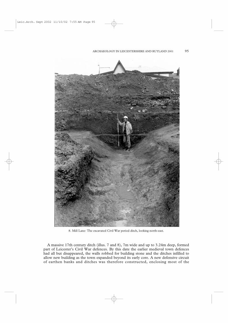
A massive 17th century ditch (illus. 7 and 8), 7m wide and up to 3.24m deep, formedpart of Leicester’s Civil War defences. By this date the earlier medieval town defenceshad all but disappeared, the walls robbed for building stone and the ditches infilled toallow new building as the town expanded beyond its early core. A new defensive circuitof earthen banks and ditches was therefore constructed, enclosing most of the
ARCHAEOLOGY IN LEICESTERSHIRE AND RUTLAND 2001 95
8. Mill Lane: The excavated Civil War period ditch, looking north-east.
Leic.Arch. Sept 2002 11/10/02 7:55 AM Page 95

prosperous north and east suburbs but not the poorer suburb to the south, which wasapparently considered expendable. Houses on the line of, or lying outside the newdefences were demolished, the Records of the Borough of Leicester record paymentsmade for taking down houses ‘beyond the south gate Centry’ in 1643-44 (Stocks 1923,334). Incorporated into the defensive line was the precinct wall of the Newarke, asubstantial stone-built wall, which had originally enclosed an ecclesiastical collegefounded in the early 14th century. Following the Dissolution of the Monasteries, thearea developed into an exclusive residential suburb, exempt from borough rates, whichwas home to many of Leicester’s wealthiest citizens. Contemporary documentaryaccounts indicate that the defensive line was modified at various times between c. 1643and 1645; it is clear, however, that the Newarke was never adequately fortified prior tothe Royalist assault on Friday 30th May 1645 (Courtney and Courtney 1992). It isprobably no coincidence, therefore, that when this attack came, it was from the south.The southern wall of the Newarke precinct, on the north side of Mill Lane – oppositethe excavation site, bore the brunt of this attack, from a battery of cannon stationedsomewhere in the vicinity of the present day Leicester Royal Infirmary, and was soonbreached. After the town’s capture by the Royalists, the breach was repaired and workon strengthening the defences around the Newarke was begun. It is unclear, however,how much was achieved prior to the Parliamentarians’ recapture of the town on June16th, just over a fortnight later, following their decisive victory at Naseby. Based on thedocumentary evidence for the inadequacy of the defences around the Newarke, it ispossible to suggest with some degree of confidence that the Mill Lane ditch dates to the
96
9. Mill Lane: The excavated Civil War period ditch, looking south-west.
Leic.Arch. Sept 2002 11/10/02 7:55 AM Page 96

period after the first siege. Less clear, however, is whether this was a Royalist workcompleted before June 16th, or a later Parliamentarian defence. The least truncatedsection of the ditch permits some appreciation of the original scale of this earthwork.With an equivalent bank on the north-west side, the difference in height between base ofditch and top of bank would have been somewhere in the region of 6.5m. Given thetime it would have taken to construct an earthwork of this scale, it may be tentativelysuggested that it was not completed until after the town’s recapture by Parliamentarianforces.
Few finds were recovered from the ditch, which would presumably have beenregularly cleaned out, and was quickly backfilled following the end of the conflict(Stocks 1923, 378). A single lead musket ball was found embedded in the north-westside of the ditch, however. Weighing 0.8 ounces (20 shot to the pound), this is smallerthan the standard sized musket shot (12 to the pound) in use at the time (Courtney1988, 3). Problems with the standardisation of military ordnance were not uncommonand 20-to-the-pound shot has been found in quantity at other Civil War period sites. Afragment of a possible lead cannon ball was also found. This is similar in size to ironcannonballs of the period previously found in the area; lead cannonballs were apparentlyused at the siege of Leicester as one was found embedded in the wall of TrinityHospital, in the Newarke, in 1901 (Courtney and Courtney 1992, 78). The incompleteand distorted shape of the Mill Lane find may represent impact damage.
This site has provided the rare opportunity for the archaeological evidence to belinked to well documented and dated events. Examination of the information from thisand other sites in the vicinity where Civil War period remains have been found, togetherwith the evidence from contemporary sources, should permit a reconstruction of theform and development sequence of the Civil War defences around the south of thetown.
Finds and records have been deposited with LCMS, accession number A17.2001.
Bibliography
Courtney, P., 1988. ‘Small arms accessories of the mid-17th century’ Datasheet 11, FindsResearch Group 700-1700. Oxford.
Courtney, P. and ‘A siege examined: the Civil War archaeology of Leicester’ Post-medievalCourtney, Y., 1992. Archaeology 26, 47-90.Finn, N., 1994. ‘Bonners Lane, Leicester’ in ‘Archaeology in Leicestershire and Rutland
1993’ TLAHS 68, 153-194 (165-170). Gossip, J., 1998. ‘York Road/Oxford Street’ in ‘Archaeology in Leicestershire and
Rutland 1997’ TLAHS 72, 156-195 (159-160). Stocks, H., 1923. Records of the Borough of Leicester 1603-1689. Cambridge.
Leicester, The Newarke, (SK 4582 3040) Ant Maull and Tam Webster
Seven trial trenches were excavated in the former William Baker premises at TheNewarke, Leicester by Northamptonshire Archaeology (NA) on behalf of JSAC, actingfor William Davis Ltd, ahead of plans to convert and extend the factory into flats andassociated parking. The site is located within the religious precinct of The Newarke,which contained the Collegiate Church of the Annunciation of the Blessed Virgin Mary,Trinity Hospital, several chantry houses and other buildings. Founded in the mid-14thcentury, The Newarke was deprived of its chantry status in 1547.
ARCHAEOLOGY IN LEICESTERSHIRE AND RUTLAND 2001 97
Leic.Arch. Sept 2002 11/10/02 7:55 AM Page 97

A number of archaeological features and layers were uncovered across the siteincluding substantial stone walls encountered to the south-east and north-eastcorresponding with the precinct’s west and north wall and a stone-lined conduit to thesouth-west, which seemed to form part of the conduits documented as existing beneathThe Newarke, near Trinity Hospital.
All of the trenches contained substantial modern overburden of varying thickness, butdeeply-stratified medieval layers were observed only in two trenches. Although limitedin range and quantity, the finds are compatible with those from a site continuallyoccupied from the medieval to present, including moulded architectural stone, a smallquantity of medieval pottery and post-medieval pottery.
Finds and records will be deposited with LCMS, accession number A25.2001.
12 New Street (SK 5853 0433) Michael Derrick and Neil Finn
A photographic survey and archaeological watching brief was undertaken by ULAS onbehalf of Freer Bouskell during the excavation of a foundation trench intended for areplacement wall to the rear of the property. The site is located adjacent to the southernboundary of the Roman and medieval defences and would have been enclosed withinthe grounds of the Greyfriars during the medieval period. Stone-built footings relatingto a cellar were observed directly below the existing building which dates to the late18th-early 19th century. The site archive will be deposited with LCMS with theaccession number A2.2001.
EVINGTON
High Street (SK 6272 0292) Simon Chapman
An archaeological evaluation, by trial trenching, was undertaken by ULAS on landformerly occupied by the South Leicester Garage. Trenching revealed the presence of athick layer of modern overburden and significant disturbance by foundations andservices, to such an extent that the natural substratum was only revealed in one trenchin the far east of the site. No archaeological deposits were observed. Records will bedeposited with LCMS, accession number A13.2001.
MOWMACRE
Mowmacre, Bursom Business Park Extension (SK 576 088) Vicki Priest
An archaeological evaluation was carried out by ULAS, on behalf of Lorien EngineeringSolutions Ltd. at Bursom Business Park, Mowmacre, Leicester in advance of aproposed Business Park extension. The work comprised the excavation of 12 trialtrenches within an area of improved grassland. Although no archaeological depositswere recorded in the majority of the trenches, immediately to the east of the maindevelopment area, some isolated features, including a gully and a post hole, producedIron Age pottery. Finds and records will be deposited with LCMS, accession numberA19.2001.
98
Leic.Arch. Sept 2002 11/10/02 7:55 AM Page 98

WEST HUMBERSTONE
Stoneham House Farm, Barkby Thorpe Road (SK 6223 0820) James Albone
On behalf of Barratt East Midlands Ltd, J. Albone of Archaeological Project Services(APS) supervised a programme of archaeological investigation in the north-eastern partof Leicester. An initial stage of desk-based research established that the site wassurrounded by numerous lithic scatters and other prehistoric sites. There were alsoseveral Romano-British settlements in moderate proximity and an Anglo-Saxoncemetery. However, subsequent trial trenching revealed only 19th-20th century remainsassociated with the farm and no artefacts earlier than the 18th century were recovered.Finds and records will be deposited with LCMS, accession number A22.2001.
WYCLIFFE
Clarence Street, Leicester (SK 5896 0476) Nicholas Crank
In summer and autumn 2001, HAT carried out an excavation at Clarence Street,previously evaluated in 2000 (TLAHS 75, 134), which lies east of the Roman towndefences in an area identified with Roman cemeteries. Excavations revealed the mosteasterly remains of a Roman cemetery comprising 62 inhumations. A number of earlierRoman features were also excavated, and included several substantial domestic andindustrial pits. A subsequent archaeological monitoring and recording exercise revealeda further 33 Roman inhumations and one earlier pit. The cemetery was characterised bya consistent burial rite that involved west-east orientation of supine inhumations lackinggrave goods, a number in nailed timber coffins. Post excavation work on this project isstill in progress at the time of writing. Finds and records will be deposited with LCMS,accession number A10.2001.
Negative watching briefs in Leicester
1 Falconer Crescent (SK 5528 0589) ULAS; General Hospital (SK 6237 0384)ULAS; Hamilton Northern Housing Area (SK 633 074) ULAS; Humberstone, St Mary’s Church Hall (SK 6258 0598) ULAS; Lower Brown Street (SK 58530341), ULAS; New Parks, Sacheverel Road, (SK 5500 0489) NA; St. Margaret’sWay (SK 5845 0514), NA.
LEICESTERSHIRE
Anstey, Cropston Road (SK 553 087) Tim Higgins
ULAS undertook an evaluation by trial trenching in advance of a housing developmentby Bloor Homes at the former wallpaper factory site on Cropston Road. The remains ofa possible medieval hollow way were found, together with rear garden activity and aboundary ditch and fence lines of cottages which contained pottery dating to the 16th to19th centuries. Finds and records will be deposited with LMARS, accession numberX.A128.2001.
Ashby By-Pass (SK 348 184) Michael Derrick and Tim Higgins
Archaeological control and supervision of groundworks was undertaken by ULAS in
ARCHAEOLOGY IN LEICESTERSHIRE AND RUTLAND 2001 99
Leic.Arch. Sept 2002 11/10/02 7:55 AM Page 99
June 2001 on behalf of Birse Construction Ltd. during topsoil stripping for soil storagefor Ashby by-pass stage 2. The topsoil strip was centered on two areas south of thevillage of Smisby. Area 1 contained a series of modern land drains and a possibledrainage ditch or hedge boundary. Both areas 1 and 2 produced flint pieces and Roman,medieval and modern pottery probably indicative of manure spreading. The site archivewill be deposited with LMARS, accession number X.A85.2001.
Ashby Magna, Old Forge Road (SP 565 905) Michael Derrick and Sally Anne Smith
An archaeological watching brief was undertaken by the ULAS between 9/7/01 and13/8/01 on behalf of Troy Newborn Homes Ltd. during the excavation of foundationtrenches. Cobbled surfaces were observed associated with earlier farmyard buildings.The site archive will be deposited with LMARS, accession number X.A103.2001.
Ashby Woulds, Furnace Lane, Moira (SK 315 155) Tim Higgins
An archaeological watching brief undertaken by ULAS for Leicestershire CountyCouncil in February 2001, during topsoil stripping, revealed evidence for a gravelspread some 4.2m wide and 0.2m deep, on either side of which were sharp, sloping cutssuggestive of ditches. The evidence is interpreted as representing the agger and flankingditches of the Roman road between Chester and Colchester, the alignment of which isprojected to run through this site. It has been confirmed nearby, to the north-west, atBath Lane, Moira (TLAHS, 73, 84). Finds and records will be deposited with LMARS,accession number X.A34.2001.
Bottesford, Pinfold Lane (SK 0816 3919) James Albone
Development near to previous discoveries of Roman remains and in the historic core ofBottesford was monitored by staff of APS who recorded a ditch and pit of 13th-centurydate. Several other pits and gullies were identified and, although undated, are probablyalso medieval. A moderately large quantity of 13th-century pottery was recovered andthis, together with the features, suggests medieval occupation on the site or in itsimmediate proximity. Fragments of Roman and prehistoric, probably Bronze Age,pottery were also retrieved. Finds and records will be deposited with LMARS, accessionnumber X.A59.2000.
Brooksby (SK 671 159) Neil Christie
From Village to Hall to College: Survey and Excavations at Brooksby 1999-2001
Since 1999 the School of Archaeology & Ancient History of the University of Leicesterhas provided a training school for undergraduates at Brooksby, located c. 10 milesnorth-east of the city centre, in Hoby with Rotherby parish, Leicestershire. This formspart of the Wreake Valley Survey, initiated in 1999. The Wreake was previously animportant river artery, and its territory includes the Iron Age hillfort of Burrough Hilland the recently discovered Bronze Age and middle Anglo-Saxon village of EyeKettleby, both of which have seen excavation (Finn 1997, 1999). The School ofArchaeology & Ancient History, in conjunction with Leicestershire Museums, has, inaddition, between 1992 and 1998, undertaken an extended fieldwalking and earthworksurvey assessment of the Barkby Thorpe parish, with geophysical and related surveywork also on the central DMV of Hamilton. It is hoped that the Wreake Valley Project
100
Leic.Arch. Sept 2002 11/10/02 7:55 AM Page 100

ARCHAEOLOGY IN LEICESTERSHIRE AND RUTLAND 2001 101
10. Brooksby
Leic.Arch. Sept 2002 11/10/02 7:55 AM Page 101
will therefore create a vehicle for publishing these previous excavations and surveys aspart of a wider scrutiny of the evolution of settlement and landscape in a discreteMidlands zone. Thus, following completion of studies at Brooksby (summer 2002), thefield school and related work will extend to other Wreake sites.
Brooksby nowadays comprises primarily an agricultural college with purpose-builtaccommodation, kitchens and dining halls, laboratories and stores serving residentialcourses, receptions and conferences; most of these units are modern, twentieth-centuryfeatures, but they gather around a much older core, comprising hall, gardens and church(see illus. 10). Visually the church of St. Michael’s is the oldest element of this core, firstdocumented in the 13th century, but containing elements indicating at least a 12th-century origin; however, much of its internal fabric and ornamentation, plus its burials,belong to the post-medieval and early modern eras. The Hall, despite restructuring, alsoprovides, in the plan of its old dining area, clear traces of a medieval origin; much of theexpanded external fabric relates to the 17th century. Chiefly to the west of both hall andchurch are extensively landscaped gardens, including ornamental waterway, and pools;further north the grounds, extending towards both railway and river Wreake, are givenover to level playing fields. Beyond the landscaped zone are a series of fields which makeup an estate of 860 acres in total (largely matching the Brooksby parish confines); someof those fields closest to the college are pasture and contain evident medieval ridge andfurrow, particularly well preserved to the east between Brooksby and the extant hamlet ofRotherby (this ridge and furrow was mapped by Hartley in the 1980s – Hartley 1987: 7,22; fig.2). The other fields, of variable dimensions, and largely hedge-bounded, arearable. Within the estate are a series of farms (Hall Farm, Hives Farm, Spinney Farm,Brooksby Grange), most of which are modern.
The estate is divided roughly into two halves by the Melton-Leicester A607 road,running NE-SW; previous fieldwork (see below) supports the view that this route is atleast late Iron Age/Roman in origin. On the northern side of the road, towards the hall,lie the presumed traces of the deserted medieval village of Brooksby and the focus ofwork undertaken in July 1999-2001. The Brooksby field schools are designed to providefieldwork training for first- and second-year undergraduates in both above-ground andsub-surface techniques, including building survey, total station and tape/compasssurvey, excavation, geophysics and finds analysis; Brooksby estate and its environs offerscope to both train and inform students on equipment, techniques and researchquestions. In the case of Brooksby the key aims are to examine and explain theearthworks and buried archaeology of the presumed DMV area, to analyse the standingarchaeology (church and hall), to assess the recovered material culture, and to setBrooksby into a wider settlement and landscape context. The work is informed byfieldwalking campaigns previously undertaken on the estate in 1990/91 and 1997 by theArchaeological Survey Team of Leicestershire Museums, Arts and Records Servicefunded by English Heritage (published as Liddle & Knox 1991 and 1997 – both reportssummarise the known archaeology, historical records and modern buildings). Thesestudies comprised systematic fieldwalking coverage of c. 650 acres of the estate grounds,illuminating fluctuating areas of land use and activity, and notably identifying the focalrole of the road from Roman times.
Thus far the excavation and geophysical work at Brooksby has failed to provide cleartestimony to the medieval village (beyond the church and hall). Documentary analysis byDr. Tony Brown reveals that the settlement, recorded by Domesday as comprising twosmall holdings, was, according to a court case of 1517, claimed to have been depopulatedand abandoned on 29 November, 1378; texts for 1388 meanwhile demonstrate a forceful
102
Leic.Arch. Sept 2002 11/10/02 7:55 AM Page 102

wasting of the lands, houses and gardens here by the Villiers family, with similaraccusations levelled against Sir John Villiers in 1488-1492. By the early 16th century,pasture land was dominant; the hall and its gardens and orchards developed from the17th century, and the 19th century saw the creation of a small deer park and the rise offox hunting. Of the lost medieval community little can be said except that it was small: inlay subsidies of 1331-2 only six householders with property of ten shillings’ worth ormore are recorded; in 1377 the population stood at just 39, whilst in 1381 there were just21 taxpayers.
We might not expect much quality or extent to the remains of such a village: the ridgeand furrow indicate a busy enough arable landscape, but this runs up close to the area ofthe modern college with hall and church, leaving little space for earthworks denoting theDMV and implying that the majority of its structures lie beneath the landscaped gardensand modern buildings. Earthwork traces exist only in the area south and south-east ofthe church and it was assumed that some of these at least are medieval. However,archaeological results in these areas have so far recognised mainly post-medieval activity:the earthwork survey (illus. 10) suggests more traces of ridge and furrow here, while theexcavations have discerned chiefly post-medieval (17th century) finds (ceramics, claypipes, metalwork, nails, tiles, animal bone) in a structure presumed to be an animal penand store (building 1 on plan); the suggestion is that this building overlies levelled ridgeand furrow. Geophysics work carried out in 2001 towards the east, across part of theformal gardens has, however, suggested possible building platforms, although it cannotbe excluded that these relate to earlier gardens/ orchards. Otherwise we must so farconclude that the lost village in fact predominantly lies directly under the collegestructures and its gardens, and that only further geophysics and targeted excavation willsecure its location and chronology.
Equally significant has been the work undertaken at the south end of illus. 10, close tothe line of the modern A-road. As noted, previous fieldwalking in the estate hadidentified areas of high Roman period activity, concentrated along this line, with somecorrelation with Iron Age and Saxon usage. Geophysics and trenching by Trent & PeakArchaeology in 2000 south of the road had identified a network of gullies, pits andpossible tracks; our studies in 2000 and 2001 extended this network over the road andtrenching confirmed an early Roman date with likely Iron Age occupation also. Further,it was possible to argue for a track feeding into the presumed medieval hollow waywhich runs on towards both church and hall. The IA/Roman features were all heavilyeroded, signifying the high level of heavy ploughing that has occurred in the area sincethe Roman period; it is unlikely therefore that any coherent structural finds will beforthcoming in the 2002 season at Brooksby.
Bibliography
Finn, N., 1997 ‘Eye Kettleby, Leicester Road, Melton Mowbray (SK 731 180)’,TLAHS 71, 88-90.
Finn, N., 1999 ‘Melton Mowbray, Eye Kettleby, Leicester Road (SK 737 181)’,TLAHS 73, 108.
Hartley, R.F., 1987 The Medieval Earthworks of North-East Leicestershire. Leicester:Leicestershire Museums, Art Galleries And Records Service
Hoskins, W.G., 1944-45:‘The deserted villages of Leicestershire’, TLAS 27, 242-264.Liddle, P. & Knox, R., The Brooksby Archaeological Survey. An Interim Report. Leicestershire1991 Museums, Arts and Records Service, LeicesterLiddle, P. & Knox, R., An Archaeological Assessment of Part of the Brooksby College Estate,
ARCHAEOLOGY IN LEICESTERSHIRE AND RUTLAND 2001 103
Leic.Arch. Sept 2002 11/10/02 7:55 AM Page 103

1997 Leicestershire, Leicestershire Museums, Arts and Records Service, Leicester. Report 97/5.
Burbage, Aston Lane (SP 450 921 - SP 451 934) Vicki Priest
An archaeological watching brief was carried out by ULAS at Aston Lane, Burbage inadvance of the renewal of a rising main pipeline by Severn Trent Water. The watchingbrief encountered some evidence for ridge and furrow and recovered a number of flintsindicating the presence of prehistoric activity in the area. Finds and records will bedeposited with LMARS, accession no X.A3.2001.
Burton Lazars, Sawgate Bridge (SK 781 172) Simon Chapman
ULAS conducted a watching brief and controlled supervision of groundworks duringthe excavation of silt traps as part of a flood-alleviation scheme on Burton Brook and theriver Eye, south of Melton Mowbray, and east of Burton Lazars, for the EnvironmentAgency. This revealed the remains of a medieval stone bridge built in several distinctphases. The first involved the laying of large cobbles in the base of the brook, which forseveral years may have sufficed as a ford crossing. At a later date a more substantialbridge was built of limestone. Evidence of this first stone construction was found onlyon the west bank of the brook, and consisted of a large D-shaped abutment terracedinto the bank of the brook. It is presumed that a wooden superstructure (which hassince been lost) may have sat atop this structure and spanned the brook to a similarstructure on the east bank. A worked oak timber stake was found in the west bankduring a later watching brief. No evidence of a second abutment was found duringexcavation, but this may have lain beyond the area of investigation or its stone maysimply have been reused in the construction of later phases of the bridge. Followingseveral years of flooding a third phase of construction was added, in the form of a well-hewn sandstone parapet. Later the banks of the brook, just down stream of the bridge,were consolidated with a broad layer of pebbles. The bridge was recorded as ‘SalgateBrygge’ in 14th-century land surveys and its name derived from the Roman ‘Sawgate’road on which it sat. This was one of the main routes from the east coast via which saltwas traded into the interior of Britain.
The site lies half a mile east of Burton Lazars where Europe’s largest leper colony andhospital founded by Roger de Mowbray in 1138, stood for over 400 years.
Finds and records will be deposited with LMARS, accession number X.A24.2001.
Castle Donington, 24 Castle Hill (SK 448 276) Tim Higgins
In December 2001, a watching brief was undertaken by ULAS for CunninghamLindsey during underpinning to arrest the subsidence of the north wall of a row ofhouses which lie on the line of the northern rampart and curtain wall of CastleDonington Castle (Scheduled Ancient Monument no 17096). Although the majority ofthe property is constructed of brick and apparently of 19th-century date, the northfacing elevation incorporates sandstone ashlar masonry and is believed to be theremnant of a stone building of medieval origin which appears in an engraving of 1792.The Scheduled Monument description notes that ‘the north wall of the present row ofhouses (which were built around the turn of the century) includes some of the fabric ofthis building. These houses are also built over older cellars, again of several phases ofconstruction’.
For the underpinning works, three shallow pits 0.80m long and 0.50m wide were
104
Leic.Arch. Sept 2002 11/10/02 7:55 AM Page 104

excavated within the northern room (currently a kitchen) of 24 Castle Hill, to the levelof existing wall foundations. Only rubble consisting of mortar, brick and sandstone wasobserved at a depth of 0.55mm below floor level and probably represents the back fill ofcellars. Finds and records will be deposited with LMARS, accession numberX.A82.2002.
Castle Donington, King’s Mills (SK 4175 2748) Steve Malone
Staff of APS examined a proposed development site on the outskirts of CastleDonington on behalf of KKA Ltd for Macdonald Hotels plc. Preliminary desk-basedresearch indicated that the development area was the probable location of a Late Saxonwatermill documented in Domesday, and definitely the site of medieval and later mills.Other industrial activities had been located in the area during the post-medieval period.However, a subsequent programme of trial trenching revealed only 18th-19th centurydeposits. Finds and records will be deposited with LMARS, accession numberX.A60.2001.
Clawson, Hose and Harby: Hose, Bolton Lane (SK 7367 2914) Steve Malone
APS supervised an evaluation at the edge of the historic core of the village for WynbrookLtd. Map evidence indicated buildings on the site in 1790 but by 1884 most of thesehad been removed. However, no remains of the structures shown on the 18th centurymap were revealed, though a sequence of drainage ditches and gullies of this periodwere recorded. No earlier remains were identified but a few redeposited fragments ofmedieval pottery were recovered. Finds and records will be deposited with LMARS,accession number X.A66.2001.
Claybrooke Parva, Claybrooke Hall (SP 4954 8800) Adrian Butler and Wayne Jarvis
An archaeological evaluation by trial trenching in advance of development was carriedout by ULAS on land adjacent to Claybrooke Hall in January 2001 on behalf of DMBuilders. Five trenches were excavated revealing a late Saxon ditch, medieval pit, postmedieval pit and two shallow undated gullies. Pottery, faunal remains and an ironartefact were recovered. Subsequently, archaeological control and supervision ofgroundworks during the construction of houses revealed further evidence of ditches, pitsand post holes which produced pottery of Saxo-Norman and later medieval dates,animal bone, and other finds. Finds and records will be held by LMARS, accessionnumbers X.A21.2001 (evaluation) X.A53.2001 (watching brief).
Cossington, Main Street (SK 603 138) Simon Chapman
Trial trenching by ULAS of a proposed stable yard and bungalow on land west of MainStreet demonstrated that no archaeological deposits would be directly disturbed by theproposed development. An undated ditch and pit were recorded in one trench, butbelow very thick topsoil, beyond the depth of proposed groundworks. Finds and recordswill be deposited with LMARS, accession number X.A33.2001.
Cossington, Cossington Quarry, Platts Lane (SK 601 135) Tim Higgins
An archaeological watching brief was undertaken by ULAS for RMC Aggregates(Eastern) Ltd., during gravel extraction at Platts Lane. The strip of topsoil and subsoilrevealed flint tools, Iron Age enclosure ditches, and Saxon pottery. These features and
ARCHAEOLOGY IN LEICESTERSHIRE AND RUTLAND 2001 105
Leic.Arch. Sept 2002 11/10/02 7:55 AM Page 105

artefacts were found 100m to the north of the Platts Lane excavation (TLAHS 74, 237)where a multi-period site was excavated, which included a Bronze Age burial moundwith secondary burials of the Anglo-Saxon period and an Iron Age circular building.The watching brief during subsequent gravel quarrying has revealed the presence ofpalaeochannels sealed below the alluvial clay and the gravel. The archive will bedeposited with LMARS, accession number X.A99.2001.
Desford, Barons Park Farm (SK 513 043) Adrian Butler
A topsoil magnetic susceptibility survey was carried out over c.3.8ha of pasture atBarons Park Farm. The data showed no evidence of susceptibility enhancement thatcould not be discounted as resulting from topographical factors. Observation ofgeotechnical test pits located no archaeological remains. The archive will be depositedwith the Leicestershire and Rutland SMR.
Desford, Peckleton Lane (SK 484 016) Jennifer Browning
An archaeological watching brief was carried out during groundworks at Caterpillar(UK) Ltd, during the construction of a new bridleway and temporary haul road close toOld Desford Lane. A sub-circular pit was revealed during the topsoil strip. It waspacked with large burnt pebbles and occasional quartzite stones. No firm datingevidence was recovered, although a crushed cattle molar was retrieved from the fill ofthe pit. Similar features at sites such as Eye Kettleby and Husbands Bosworth arethought to date from the Saxon period and Iron Age, respectively. The function of thepit is unclear but the stones may have been heated during cooking or craft activities. Noother features or deposits were identified. The work was commissioned by W. S. AtkinsConsultants Ltd for Caterpillar (UK) Ltd. The archive will be held by LMARS underthe Accession Number X. A12.2000.
Drayton, 6 Main Street (SP 830 923) Tim Higgins and Sally Anne Smith
An archaeological watching brief was carried out during the removal of car park surfacesand topsoil and subsoil stripping in preparation for housing development. The onlysignificant archaeological feature observed were the stone footings of a possible latemedieval or early post medieval building. Finds and records will be deposited withLMARS, accession number X.A37.2001.
Earl Shilton, Oaks Way (SK 4625 9760) John Thomas
Trial trenching was undertaken by ULAS in October 2001 on behalf of Byrne BuildingCo. to evaluate the site prior to development. No remains of archaeological significancewere recorded. The archive will be deposited with the Leicestershire and Rutland SMR.
Freeby, Stapleford Park Golf Course (SK 814 181) Tom Lane
Earthmoving was monitored and archaeological recording undertaken by staff of APSduring construction of a golf course at Stapleford Hall. A number of pits and drainagegullies yielding late and post-medieval pottery were recorded adjacent to the scheduledarea of the former village of Stapleford. No traces of a Roman road postulated to crossthe site were revealed but a linear band of gravel east of the hall is likely to mark aploughed out medieval route.
Near to an early, extinct, river channel were traces of an Iron Age site. Located in a
106
Leic.Arch. Sept 2002 11/10/02 7:55 AM Page 106
test pit and in a newly-cut ditch, the features lay sealed beneath alluvium in the valley ofthe River Eye. No traces of Anglo-Saxon features were found in the vicinity of theknown pottery scatter of that date. Instead, topsoil removal revealed a series ofinterconnecting gullies, pits and post holes, some of which described a circularstructure. A small pit near to the structure was filled with slag. Pottery was sparse in theexposed area, but was all of Roman date. Finds and records will be deposited withLMARS, accession number X.A18.1997.
Freeby, Garthorpe and Wymondham, Water Mains Renewal (SK 780 170 to SK 860 230) Sally Anne Smith
An archaeological watching brief was undertaken by ULAS between February 1999 andMarch 2000 on behalf of Severn Trent Water Ltd. The work was carried out duringwater mains renewal in the villages of Brentingby, Wyfordby, Freeby, Saxby, Garthorpe,Coston, Wymondham and Edmondthorpe, Leicestershire. Evidence of medievaloccupation and earlier cobbled surfaces was found. The site archive will be depositedwith LMARS, accession number X.A55.2001.
Frisby on the Wreake and Kirby Bellars, Water Main Renewals (SK 690 170 to 730 185) Sally Anne Smith
An archaeological watching brief was undertaken by ULAS between May 1999 andMarch 2000 on behalf of Severn Trent Water Ltd. The work was carried out duringwater mains renewal in the villages of Frisby on the Wreake and Kirby Bellars,Leicestershire. Evidence for earlier cobbled surfaces was revealed. The site archive willbe deposited with LMARS, accession number X.A54.2001.
Great Dalby, Burrough End (SK 774 141) Jennifer Browning
In May 2001, an archaeological watching brief was undertaken by ULAS duringgroundworks for a new house within the medieval village core, adjacent to a cottage of17th-century date. No early archaeological finds or deposits were observed but thefoundations of two stone walls, probably dating from the post-medieval or modernperiod, were located during this work. The archive will be held by the LeicestershireSMR.
Glen Parva, Little Glen Road (SP 575 980 to 580 983) Sally Anne Smith
An archaeological watching brief was undertaken by the ULAS between 30/1/01 and5/2/01 on behalf of Severn Trent Water and Haswells during groundworks for the layingof a new sewer. Although two prehistoric flint flakes were recovered from the topsoilstrip, no significant archaeological features were encountered. The site archive will bedeposited with LMARS, accession number X.A42 2001.
Hinckley, Coventry Road (SP 405 930) Tim Hallam and Mark Holmes
An area of 2.5 ha was excavated by NA in advance of housing and communitydevelopment by Crest Nicholson Residential Midlands (Limited). The site had beenevaluated in 1999 (TLAHS 74, 242) and it included much of two separate settlementsof middle Iron Age and Roman date, the latter bounded on the south by the A5, the oldRoman Road of Watling Street. The ground was generally flat and at the time of theexcavation was given over to rough grazing. The underlying geology was Boulder Clay,
ARCHAEOLOGY IN LEICESTERSHIRE AND RUTLAND 2001 107
Leic.Arch. Sept 2002 11/10/02 7:55 AM Page 107

and the acid soils meant that bone had not generally survived and the pottery was inpoor condition. A watching brief continues on adjacent areas.
The Iron Age settlement lay to the west, and comprised seven roundhouse ringditches forming an open settlement set within a system of curvilinear ditches, whichpartially enclosed some of the roundhouses. There were two large roundhouses,enclosed by regular circular ditches 16m to 18m in diameter, with eastern entrances. Asmaller house had a similarly regular ring ditch, but the others were defined by lessregular partial arcs of ditch.
There was a scatter of smaller pits, and a large pit at the northern edge of theexcavated area was c. 6.00m in diameter and c. 2.50m deep. A total of 217 sherds ofhandmade pottery was recovered from the settlement. Occupation appears to havecommenced during the early-middle Iron Age and continued through the middle IronAge. No late Iron Age or early Roman activity was present on the site to denote directcontinuity of settlement.
Roman activity at the east of the site was centred on a small rectangular enclosurec.17m long by c.10m wide with a 1.5m wide entrance in its southern side. No remains ofa house survived, but the area immediately to the south of the enclosure entrance washeavily disturbed and a number of depressions had been in-filled with ash deposits. Thesmall enclosure was set within the eastern of two abutting rectangular enclosures.
There was a scatter of contemporary pits to the west, both within and outside the twoprincipal enclosures, and an east-west ditch cutting across the Iron Age settlement isprobably also a contemporary boundary. The overall date range of the Roman pottery
108
11. Hinckley, Coventry Road
Leic.Arch. Sept 2002 11/10/02 7:55 AM Page 108

assemblage was probably not more than 150 years, spanning the earlier 2nd secondcentury to just after the mid 3rd century AD. The nature of the assemblage suggeststhat the site was peripheral to a principal focus of occupation.
Across the site there was a regular system of north-east to south-west aligned furrows,the ploughed out remnant of the medieval field system.
Finds and records will be deposited with LMARS, accession number X.A69.2002.
Hinckley, Nutts Lane (SP 4090 9295) Chris Jones
Trial trenches were excavated by NA on behalf of JSAC for Bryant Homes TechnicalServices Ltd. The objective was to determine whether there were remains related to anIron Age and Roman settlement located 200m to the west, (Hinckley, Coventry Road,above), or other sites associated with Watling Street, a former Roman Road and presentday A5, some 300m to the south. Recent ploughing and modern field drains were foundin all the trenches. Rubble, possibly relating to the demolition of a Second World Warpillbox was found. No archaeological remains or artefacts were found. Records will bedeposited with LMARS, accession number X.A70.2002.
Hinckley, 1-3 Regent Street (SK 4255 9389) Neil Finn
ULAS undertook an historic building assessment of 1-3 Regent Street, Hinckley onbehalf of Alliance Traders Ltd. This established that the street frontage range is oftimber-framed construction, probably of 16th- or 17th-century date, with a laterGeorgian façade. To the rear of this is a late 17th- or early 18th-century range, behindwhich are two small cottages of late 18th-19th century date. Development proposals hadnot been finalised at the time of writing. Records will be deposited with LMARS.
Huncote, Forest Road (SP 5160 9850) Martin Shore
Following evaluation of a proposed gravel quarry by geophysical survey, fieldwalkingand open area evaluation, a watching brief and metal-detector survey was undertakenclose to the findspot of a late Iron Age linch pin. The watching brief during topsoilstripping prior to sand and gravel extraction located features of Iron Age date.Subsequent machine stripping revealed a sub-rectangular Iron Age enclosure, which wasthen subject to an excavation. This revealed evidence of a small farmstead which was inuse during the late Iron Age, with possible continuation into the early Roman period.This included two circular buildings and a series of stock control boundaries within theenclosure. Charred cereal remains including spelt and emmer wheat and animal bone,including cattle, horse and sheep/goat were recovered suggesting a small-scale mixedeconomy, possibly for an extended family group. The finds and archive are to bedeposited with LMARS, accession number X.A55.2000.
Husbands Bosworth (SP 635 825) Matthew Beamish and Jon Coward
Living on the Edge – the environs of a Neolithic causewayed enclosure.
In 1998, geophysical survey by ULAS located a major Neolithic monument atHusbands Bosworth, Leicestershire – a causewayed enclosure dating from around 3000BC – the first of its kind known from the county (TLAHS 73; 100 74, 247; 75, 145).The monument consisted of a circular open area, 150m in diameter, enclosed byinterrupted banks and ditches and would have served for meetings and ceremonies forthe early farming communities living in the surrounding Soar, Welland, Swift and Avon
ARCHAEOLOGY IN LEICESTERSHIRE AND RUTLAND 2001 109
Leic.Arch. Sept 2002 11/10/02 7:55 AM Page 109

110
12 Husbands Bosworth: site plan
Leic.Arch. Sept 2002 11/10/02 7:55 AM Page 110
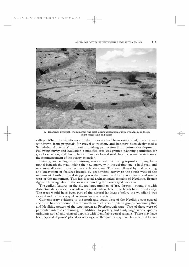
valleys. When the significance of the discovery had been established, the site waswithdrawn from proposals for gravel extraction, and has now been designated aScheduled Ancient Monument providing protection from future development.Following survey and evaluation a modified area was granted planning permission forgravel extraction, and three phases of archaeological work have been undertaken sincethe commencement of the quarry extension.
Initially, archaeological monitoring was carried out during topsoil stripping for atunnel beneath the road linking the new quarry with the existing one, a haul road andnew areas allocated for extraction and landscaping. This was followed by trial trenchingand excavation of features located by geophysical survey to the south-west of themonument. Further topsoil stripping was then monitored to the north-west and south-west of the monument. This has located archaeological remains of Neolithic, BronzeAge and Iron Age date in the areas surrounding the causewayed enclosure.
The earliest features on the site are large numbers of ‘tree throws’ – round pits withdistinctive dark crescents of silt on one side where fallen tree bowls have rotted away.The trees would have been part of the natural landscape before the woodland wascleared and the causewayed enclosure was constructed.
Contemporary evidence to the north and south-west of the Neolithic causewayedenclosure has been found. To the north were clusters of pits in groups containing flintand Neolithic pottery of the type known as Peterborough ware. Two of these were ofparticular interest containing, in addition to pottery and flint, large saddle querns(grinding stones) and charred deposits with identifiable cereal remains. These may havebeen ‘special deposits’ placed as offerings, or the querns may have been buried for re-
ARCHAEOLOGY IN LEICESTERSHIRE AND RUTLAND 2001 111
13. Husbands Bosworth: monumental ring ditch during excavation, cut by Iron Age roundhouse (right foreground and inset)
Leic.Arch. Sept 2002 11/10/02 7:55 AM Page 111

use during seasonal visits to the site. A pit to the west of the enclosure contained slightlylater Beaker style pottery of Late Neolithic – Early Bronze Age date.
The area south of the enclosure had rather different Neolithic remains including acircular monument and human burials – a crouched inhumation and two cremations.
The crouched inhumation burial lay at the base of a deep rectangular pit which wascapped by a layer of burnt cobbles and stones. The burial was positioned with the headto the south-east. Bone survival was unusual in that it was either present in generallyreasonable condition or there was very little trace of it. The pelvis, ribcage and spine andmost of the left leg and arm (i.e. the lower side of the body) were missing. Althoughsome of the skull had decayed badly one side of the upper jaw was in good condition.Initial indications suggest that the burial was of a 30 – 35 year old male.
A tool kit of five Late Neolithic/Early Bronze Age flints, which may have originallybeen in a bag, lay by the knees, a flint flake near the skull, and two pieces of animalbone with a flint flake were by the wrist. Charred remains of an oak plank had been laidon its edge along the length of the side of the pit to the north-west of the burial. Theplank’s position in the pit corresponded with a natural layer of loose silt and gravel alongone side, and it may have acted as shuttering. This could imply that the pit was dugsome time before the body was placed in it, or that the body remained uncovered forsome time before the pit was filled in.
Near the crouched burial were several Iron Age pits, dug perhaps 1500 years after theburial, some of which contained quantities of large burnt cobbles. Could these stoneshave come from a stone mound or cairn which had once covered the burial pit?
Trial trenching and excavation was carried out in two further areas of the quarryextension, targeting features located by geophysical survey, including a ring ditch and asmall rectangular enclosure. The excavation confirmed the presence of the ring ditchwith two narrow causeways to the north-west. On the basis of the geophysical surveys ithad been interpreted as a ploughed-out circular Bronze Age barrow. However althoughthe ditches were extremely deeply cut, neither a burial was present nor any feature likelyto have contained one, and there was no evidence of whether it had a mound or externalbanks. Faint responses, perhaps indicating traces of external banks in the topsoil, hadbeen found during the initial geophysical survey. The ditch varied in depth perhapssuggesting that it had originally been dug out by different groups of people. Few findswere present the only dating evidence being sherds of Neolithic Peterborough warepottery suggesting use around 3000-2500 BC.
Two pit alignments, one crossing the ring ditch, were also located. Although notclosely datable these may be evidence of land division in the Late Bronze Age - EarlyIron Age. More tangible evidence of occupation occurred in the Middle to Late IronAge with a circular building, pits and enclosures to the south, and pits and an enclosureto the north of the monument. The circular building cut the upper layers of the ringditch, suggesting that the monument was no longer visible at this time, with the banksor mound having eroded and the ditch now backfilled. By this time when the land wasbeing divided up, it is unclear whether the causewayed enclosure was still visible as anearthwork
The work to date at Husbands Bosworth has shown that the causewayed enclosurewas a focus of activity during the prehistoric period with evidence of seasonaloccupation, the construction of a circular monument - perhaps a local variation of a‘henge’ - and burials during the Neolithic. There appears to have been a decline inactivity during the Bronze Age until a period of land division using pit alignments,perhaps early in the first millennium BC. By the Late Iron Age the land was being
112
Leic.Arch. Sept 2002 11/10/02 7:55 AM Page 112

settled more intensively with several enclosures and at least one circular building. It isuncertain when the causewayed enclosure ceased to be visible as a landscape feature.Further work may help to elucidate what influence this important monument had onchanges to the surrounding landscape over time.
We would like to thank Lafarge Redland Aggregates and their consultants OxfordArchaeological Associates for their help and co-operation during this project. Recordswill be deposited with LMARS, accession number X.A83.1998.
Land at Ibstock Quarry (SK 4260 1050, centre) BUFAU
An archaeological evaluation was carried out in November 2001 in advance of aproposed haul road on land used as a clay stock-piling area, adjacent to the present clayquarry. The trial trenches revealed no cut archaeological features. The remnants ofmedieval or post-medieval plough furrows were encountered in most trenches. Severalabraded sherds of grog-tempered Iron Age pottery were recovered from a root hole butwere not found in association with any archaeological features. The work wasundertaken by Birmingham University Archaeological Field Unit (BUFAU) on behalfof JSAC. Finds and records will be deposited with LMARS, accession numberX.A135.2001.
Kirby Muxloe, Kirby Park Farm, Ratby Lane (SK 910 057) Rob Atkins
An archaeological trial excavation was undertaken on behalf of JSAC at Kirby ParkFarm. No archaeological features were found, apart from recent features relating to bothformer brickworks and a farm that had once stood in the development area. Finds andrecords will be deposited with LMARS, accession number X.A39.2002.
Laughton, Home Farm, Main Street (SP 6590 8908) Neil Finn
ULAS carried out a watching brief on repairs to Home Farm, Main Street, Laughton, aGrade II listed building. The earliest, timber-framed range of the farmhouse was foundto be of reversed assembly construction, whereby the wall-plate is located above the tie-beam, rather than beneath it as is the case in normal assembly building. This type ofconstruction is not uncommon amongst the mud and stud buildings of Lincolnshire.Another similarly-constructed building has been found, some 3 miles to the south atHusbands Bosworth, where a section of mud walling also survives. Research is ongoing.Records will be deposited with LMARS in due course.
Long Whatton, Breedon-on-the-Hill, Tonge and Wilson (SK 402 227 to SK 423 250) Sally Anne Smith
An archaeological watching brief was undertaken by ULAS between October andDecember 2000 on behalf of Severn Trent Water Ltd. The work was carried out duringwater mains rehabilitation. Evidence for early road surfaces and post-medieval activitywas revealed. The site archive will be deposited with LMARS, accession numbersX.A1.2002 (Long Whatton) and X.A2.2002 (Breedon, Tonge and Wilson).
Loughborough, The Rushes (SK 535 199) Michael Derrick
An archaeological evaluation of land off The Rushes, Loughborough was undertaken byULAS in November 2001 for Metrobrook Ltd. In advance of a proposed retaildevelopment. A partial evaluation of the area conducted by L-P Archaeology earlier in
ARCHAEOLOGY IN LEICESTERSHIRE AND RUTLAND 2001 113
Leic.Arch. Sept 2002 11/10/02 7:55 AM Page 113

April 2000 (TLAHS 75, 148) revealing traces of late 18th and 19th-century activity inthe form of gullies and brick walls and a dump of clay pipe and associated wasters. Thisstage of an evaluation was undertaken following the demolition of buildings along thestreet frontages of The Rushes and Bridge Street. Seven trenches were excavated, two ofwhich revealed traces of possible medieval stone footings and a pit containing a sherd ofmedieval pottery. A concentration of clay pipe and associated waste material wasrecovered from an earlier stage of this evaluation. Finds and archive will be depositedwith LMARS, accession no. X.A131.2001.
Lutterworth, The Hind Hotel, High Street (SP 545 843) John Thomas
An archaeological watching brief was carried out by ULAS in November 2001 duringgroundworks for several new dwellings on land to the rear of the former ‘Hind Hotel’.Near to the back of the former hotel, evidence was revealed for post-medieval layers ofthe 17th or 18th century, possibly indicating demolition or dumping of debris to raisethe surface levels. Elsewhere, to the west of the building, evidence was recovered ofintensive quarrying, probably to extract the natural sand and gravels which exist on thesite. Although limited dating evidence suggested a 13th- or 14th-century date for someof the quarries, most remained undated. The fact that there was little evidence of thequarry pits inter-cutting however, may suggest a degree of contemporaneity between thefeatures. The archive for the site will be lodged with LMARS, accession numberX.A133.2001.
Lutterworth, Mill Farm (SK 547 840) Simon Chapman and Vicki Priest
Excavations at the site of Mill Farm, Lutterworth, on behalf of Hallam LandManagement, were undertaken by ULAS between June and September 2001.
The site, earmarked for future development, occupies the well-known historical site ofthe hospital of St. John the Baptist. The hospital was founded on land known locally as‘the warren’ during the reign of King John in 1218, and was dissolved in 1577. Thehospital complex was a wealthy institution in its day, its revenue being greater than thatof the contemporary parish church of St. Mary’s. Much of this wealth was doubtlessgenerated by two mills, documented as belonging to the estate upon its dissolution in1577, and from farming land at Gilmorton, Cotesbach, Shawell and Bitteswell. It is,however, unclear whether the hospital mills occupied the ‘warren’ site itself, close to the18th-19th century watermill (demolished in the 1970s) from which ‘Mill Farm’ took itsname.
In 1631 a Royalist veteran of the English civil war, by the name of Colonel WilliamCole, occupied a mansion house on the site, possibly built from the stone of the ruinedhospital, and took over ownership of the two spital mills. The precise location of thehospital structures thus became lost and forgotten.
In the 1890s, rubble and human bones were discovered during the construction ofwhat is now the A426 main road. Not only had remnants of the hospital buildings beenunearthed but, for the first time, there was evidence that the hospital had its owncemetery.
Archaeological interest in the site was initiated in 1996 when the new landowners,Hallam Land Management proposed to redevelop the site. ULAS was commissioned toundertake minor evaluation trenching of the site in an attempt to discover the location,nature and extent of any archaeological remains. These evaluations proved the existenceof the hospital cemetery by the discovery of a possible five graves (two of which were
114
Leic.Arch. Sept 2002 11/10/02 7:55 AM Page 114

ARCHAEOLOGY IN LEICESTERSHIRE AND RUTLAND 2001 115
14. Lutterworth, Mill farm: Burial with medieval floor tile
Leic.Arch. Sept 2002 11/10/02 7:55 AM Page 115

116
15. Lutterworth, Mill Farm: Coffin burial
Leic.Arch. Sept 2002 11/10/02 7:55 AM Page 116

excavated fully to reveal well preserved skeletons). Spreads of cobbles also hinted at thepresence of structures, though their character was obscure.
In 2001 ULAS was commissioned to carry out more extensive work to ensure satis-factory recording of the areas of archaeological importance which would be affected bythe proposed development. In particular a large area was stripped to better define thecemetery and the possible cobble structures. Twenty-two complete graves were identifiedin a very overgrown plot of land to the south of the farmhouse. There had been muchdisturbance to this cemetery in the years since its abandonment, including modernditches and sand quarrying pits, which had clearly destroyed many more graves, judgingby the large quantities of disturbed human bones in their backfills. The excavated gravesall contained well-preserved skeletons, all but one of which were interred according toChristian tradition, with their heads at the west end of the graves. One individual, theonly juvenile, was buried the other way round, with the head at the east.
Despite the Christian custom of excluding grave-goods from burials, some interestingartefacts were recovered from the grave fills. One individual was found to be wearing avery plain ‘penannular’ style buckle, possibly uses as a shroud fastening, while anotherwas found with six 14th-century floor tiles, four of which were decorated with the Armsof Beauchamp (illus. 14). Although most of the burials appeared to be simpleinterments, without coffins (the bodies may simply have been wrapped in shrouds that
ARCHAEOLOGY IN LEICESTERSHIRE AND RUTLAND 2001 117
16. Lutterworth, Mill Farm: cobble-floored structure
Leic.Arch. Sept 2002 11/10/02 7:55 AM Page 117

have since rotted), one grave was found to incorporate a wooden coffin held togetherwith iron nails. Interestingly this coffin burial was also the only double interment, foundin ‘double-decker’ style below the burial containing the tiles (illus. 15).
Detailed laboratory analysis of the skeletons indicated that the population consistedprimarily of mature adult males, bearing the obvious signs of old age; arthritis was a verycommon finding. Only one female and one juvenile, of 15 years, broke the trend. To thesouth-west of the cemetery area, a simple track was identified running in a north-west tosouth-east direction. This made use of small rounded pebbles embedded in clay,presumably to stabilise the ground and to prevent rutting by cartwheels. This track mayhave led from the hospital buildings to the cemetery.
Adjacent to the pebble track lay a large cluster of cobbles which appeared to form theinternal flooring of a cobble building (illus. 16). A slate-lined drainage channel could beseen below the floor and the remnants of some external mortared walls were also visible.Unfortunately, much of this structure had been destroyed by a modern farm building.Few datable finds were recovered although some fragments of floor tiles (similar tothose found in the grave) were identified. It is, however, uncertain whether the 14th-century tile fragments were contemporary with the structure or whether they had beenincorporated into its fabric at a later date. Additional cobble structures, including a longenclosure wall, were also identified within the excavation area.
A great deal of analytical work remains to be completed on the finds from the site atMill Farm, and it is hoped that in the near future a more detailed picture may be formedof the nature of these remains. What is already apparent is that the latest excavationshave succeeded in locating at least part of the lost hospital of St. John the Baptist.
We would like to thank Hallam Land Management for their help and co-operationwith this project. Finds and records will deposited with LMARS, accession numberX.A84.2001.
Melton Mowbray, Dalby Road (SK 7485 1880) Neil Finn
Trial trenching by ULAS on behalf of Leicestershire County Council of two adjoiningareas of land, around the police station south of Leicester Road, and north and west ofthe Uplands off Dalby Road, located archaeological remains of prehistoric, Anglo-Saxonand post-medieval date. Prehistoric remains included at least one Late Neolithic (c.3000-2000BC) pit, in addition to settlement-related features of Late Bronze Age-IronAge (c. 1000BC- AD43) date. Attributable to the early Anglo-Saxon period (c. AD450-600) were two ditches. In the 17th-19th centuries, areas of the site were extensivelyquarried. More recently, in the late 20th century, the topography of the eastern half ofthe area was significantly altered, by the dumping of building waste on the site. Onlyvery limited evidence of Saxo-Norman and medieval activity was encountered, in theform of a few residual pottery sherds of these periods. No evidence was found tosubstantiate the interpretation of ‘the Mount’, a Scheduled Ancient Monument (SM17023) located in an adjacent field, as a Norman castle motte. Finds and records will bedeposited with LMARS, accession number X.A68.2001.
Melton Mowbray, King Street (SK 7538 1923) Michael Derrick and Wayne Jarvis
An archaeological evaluation was undertaken by ULAS at King Street, MeltonMowbray, on behalf of Corporate Architecture Ltd. in advance of the construction of apolice station. The site had previously been occupied by concrete and brick buildings ofmid 20th-century date. Three evaluation trenches were excavated in the area. A gully
118
Leic.Arch. Sept 2002 11/10/02 7:55 AM Page 118

containing Iron Age and early Saxon pottery together with one piece of burnt flint wasobserved in trench 1 while in trench 2 Iron Age scored ware was recovered from a ditch.Trench 3 contained modern demolition material. A subsequent watching brief duringgroundworks identified further features including a large ditch and several pits thatproduced medieval finds, an undated possible gully, and post-medieval buildingdemolition debris. Finds and records will be held by LMARS, accession no.X.A87.2001.
Melton Mowbray, Lag Lane (SK 772 186) Wayne Jarvis
An archaeological evaluation was undertaken by ULAS on behalf of Edmund NuttallLtd. on land adjacent to Lag Lane in advance of the proposed excavation of a borrowpit as part of the Melton Mowbray flood alleviation scheme. Worked flint, andprehistoric and medieval pottery sherds were recovered during machining of two trialtrenches, however no archaeological deposits were identified. This material may bederived by plough from upslope, as the site has ridge and furrow surviving. The sitearchive will be held by LMARS, accession no. X.A100.2001.
Melton Mowbray, Brentingby Embankment Site - east of river Eye (SK 776 186) Wayne Jarvis
Trial trenching as part of the Melton Mowbray flood alleviation scheme revealed anuneven-based linear feature running down to the river valley. This feature produced lateBronze Age/early Iron Age pottery, and worked flint. Unstratified material was alsorecovered including Mesolithic reused flint. Finds and records will be held by LMARS,accession no. X.A4.2002.
Melton Mowbray, 22-31 and 33 Nottingham Street (NGR SK 7513 1922) A. Gnanaratnam
Between 16 February and 28 May 2001, an archaeological watching brief wasundertaken by ULAS at 22-31 and 33 Nottingham Street, Melton Mowbray, forWilkinson Hardware Stores Ltd. The work consisted of ground reduction in the gardenat the rear of the property and alterations to the existing building.
In the backyard, a modern build-up sat over a post-medieval sandy gravel thatextended over most of the garden. This sealed an earlier garden soil with traces ofpitting. At the rear of the garden the stone footings of a substantial wall were uncovered,which was probably a property boundary. Adjacent to this was a late post-medieval ormodern stone-walled structure with a cobbled floor and evidence of in situ burning
Within 23-31 Nottingham Street, a substantial stone-built wall was revealed, which was probably an early phase of the cellar, which had been later faced in brick. The stone wall was undated but is likely to be of either medieval or post medievaldate. The gable walls of both 23-31 and 33 Nottingham Street were shown to be of18th-century, narrow brick construction. The two properties appeared to share a party wall. The full extent of the walls was not seen but no earlier relict features wereseen preserved within them. The remaining walls were of either 19th-or 20th-centurybuild.
Finds and records will be held by LMARS, accession number X.A17.2000.
ARCHAEOLOGY IN LEICESTERSHIRE AND RUTLAND 2001 119
Leic.Arch. Sept 2002 11/10/02 7:55 AM Page 119

Orton-on-the-Hill, (SK 305 038) Michael Derrick and Sally Anne Smith
An archaeological watching brief was undertaken by ULAS during March and April1999 on behalf of Severn Trent Water Ltd during water mains renewal. Earlier roadsurfaces were revealed beneath the modern road. The site archive will be deposited withLMARS.
Quorn, Pillings Lock (SK 563 182) Matthew Beamish
At the request of Lindsey Archaeological Services, the drilling of six boreholes wasobserved by ULAS in fields to the west of the River Soar and Grand Union Canal (SoarNavigation) at Pillings Lock, Quorn. Alluvial sediments including some containingvisible paleoenvironmental material were observed. A western gravel terrace and an areaof disturbance were also identified. Records will be deposited with LMARS.
Ratby, Station Road (SK 513 055) Steve Jones
An archaeological evaluation by trial trenching was undertaken by ULAS on behalf ofWimpey Homes in advance of residential development. The site was fund to havesuffered from considerable modern disturbance and no archaeological deposits wereencountered. Records will be deposited with LMARS.
Seagrave, Abbotsbury House, 31 Swan Street (SK 618 175) Tim Higgins
An archaeological watching brief was undertaken by ULAS on behalf of Southlong EastMidlands Ltd, during the topsoil and subsoil stripping for an extension and constructionof houses and garage. The only archaeological features located were a group of stonespreads found on the west side of Abbotsbury House, which may have predated thebuilding. The site archive will be deposited with the LMARS under the accessionnumber X.A31.2000.
Seagrave, Hall Farm Wayne Jarvis
A watching brief and salvage excavation during groundworks for residentialdevelopment was undertaken by ULAS for Soar Valley Homes and Mr. C.R. Evans.The site revealed 12th-13th century medieval features, including post holes, gullies andpits, providing important evidence of early medieval Seagrave. A building appraisal ofthe former chapel on the west side of the farmyard established that this was a formeragricultural building converted for use as a Wesleyan Methodist chapel. Finds andrecords will be deposited with LMARS, accession number X.A67.2001.
Shangton, Orchard Cottage (SP 714 962) Sally Anne Smith
An archaeological watching brief was undertaken by ULAS, on behalf of Mr. C. Pettit,in September 2000 during groundworks for a new dwelling. Evidence of medieval andpost-medieval activity within the development area was suggested by the presence of acobbled spread and pottery finds. The site archive will be deposited with LMARS,accession number X.A66.2000.
Shepshed, Charnwood Brick and Tile Works (SK 480 179) Jon Coward
An archaeological evaluation by trial trenching was carried out by ULAS at theproposed extension of the clay pit at Shepshed for Charnwood Brick and Tile Works
120
Leic.Arch. Sept 2002 11/10/02 7:55 AM Page 120

Ltd. No significant archaeological remains or finds were located. Records will bedeposited with LMARS.
Sproxton, Saltby, Stonesby Road (SK 8499 2619) Paul Cope-Faulkner
A watching brief was undertaken, by F. Walker of APS, during development in themedieval village core and near to previous discoveries of prehistoric remains. Anundated pit was revealed and pottery of medieval and 19th century date was recovered.Finds and records will be deposited with LMARS, accession number X.A132.2001.
Stapleton, St. Martins Church (SP 434 985) Tim Higgins and Simon Chapman
Trial trenching by ULAS of land for a proposed extension to the church burial groundof St. Martin’s, Stapleton revealed the presence of extant earthworks, and variousmedieval deposits, including a possible surface, below topsoil. Finds and records arewith LMARS, accession number X.A16.2001.
Stockerston, Church Lane (SK 8365 9755) Jennifer Browning
An archaeological evaluation in the form of trial trenching was carried out on landadjacent to Church Lane in May 2001 by ULAS on behalf of Mr. P. Bromwich. Theproposed development site contains earthworks and is part of a larger group ofearthworks, thought to represent the shrunken medieval village. The earthworks affectedby the proposed development were surveyed. In addition, two trenches were excavated,revealing evidence of medieval occupation, including medieval ridge tile, stone rubble and a possible wall. Finds from the top of the archaeology, directly below thetopsoil, indicate that the area may have fallen out of use in the 17th or possibly even the 18th century. The archive will be held by LMARS under the accession numberX.A81.2001.
Stonesby, Water Main Renewals (SK 810 240 to 875 320) Sally Anne Smith
An archaeological watching brief was undertaken by ULAS between January 1999 andOctober 1999 on behalf of Severn Trent Water Ltd. The work was carried out duringwater mains renewal in the villages of Stonesby, Sproxton, Saltby, King Lud’sEntrenchments, Croxton Kerrial, Knipton and Harston, Leicestershire. Evidence for apossible medieval wall footing at Stonesby, pits and ditches at Saltby airfield and apossible continuation of King Lud’s Entrenchment across the line of the road and ontowards The Drift were located. The site archive will be deposited with LMARS underthe accession number X.A26.2001.
Swinford, Chapel Street (SP 569 795) Michael Derrick and Sally Anne Smith
An archaeological watching brief was undertaken by ULAS on 4/6/01 on behalf of Mr.N. Salt in advance of building works. A pit or ditch was observed but no datingevidence. A flint flake was recovered from unstratified material. The site archive will bedeposited with LMARS, accession number X.A80.2001.
Syston, Fosse Way (SK 618 126) Adrian Butler
A topsoil magnetic susceptibility survey was carried out by ULAS on behalf of LaFargeRedland Aggregates at land west of Fosse Way, Syston. Low levels of susceptibility were
ARCHAEOLOGY IN LEICESTERSHIRE AND RUTLAND 2001 121
Leic.Arch. Sept 2002 11/10/02 7:55 AM Page 121

encountered indicating probable alluvial cover over shallow gravels. Enhancedsusceptibility lineations and areas detected may suggest some archaeological survival.
Thurlaston, New Haven Farm (SK 492 010) Wayne Jarvis
Archaeological exploratory fieldwork was undertaken by ULAS on behalf of Mr.Michael Moore at New Haven Farm, Thurlaston in advance of the excavation of aconservation pond. No archaeological deposits or finds were identified during trialtrenching. The site archive will be held by LMARS, accession no. X.A34.2002.
Tur Langton, Rose Cottage (SP 712 946) Mike Dawson
In June and July 2001, a watching brief, during the construction of a new building, tookplace in a currently unoccupied medieval close between The Chestnuts and RoseCottage, High Street Tur Langton. The site was partially landscaped in the late 1990s.Topographically, the close was some 30 metres wide and 100 metres in depth,stretching away to the south. In the centre was a clay ridge in which a small pond hadbeen excavated, and in the south a small stream, ultimately a tributary of the RiverWelland.
Archaeological Evidence
Excavation of the footings for a driveway and house foundations revealed the remains ofa boundary wall, part of the two buildings, and a cobbled surface sealed beneath topsoil.All the structures were left in situ with the exception of the cobbled surface which wasexcavated.
The earliest building comprised a loam-bonded sandstone wall, partially robbed,enclosing a worn and partially robbed sandstone flagged floor. The scale of the buildingand its structure suggest construction, probably at the earliest, in the 16th century. Thetechnique and form of the building is consistent with a single bay cottage in the localvernacular. A small quantity of pottery recovered from the top soil horizon above thestructure, was 19th century in date (Soden 2002, 19) confirming the map evidencewhich indicates the building was demolished by 1912 (Holloway, Price and Co. 1912).
The second building, slightly further to the south, was a small structure consisting ofthree lime-mortared walls enclosing an area of approximately 2 sq. metres. No findswere recovered and the date of this building is assumed to be late 19th century as itappears on the 1st edition OS 1886 but not on the sale catalogue of 1912, where theland is described as gardens.
Towards the centre of the site, the ground rises to form a low clay ridge; on thenorthern face there is a small pond. South of the pond, on the ridge itself, was a cobbledsurface some 15 metres wide, which may be the remains of the track or possibly yardsurface. Pottery indicates an origin in the 13th century. The pottery comprised shelleycoarsewares and three sherds of Lyveden/Stanion B-ware from the north-eastNorthamptonshire village industries. A single fragment of heavily quartz-temperedhand-made pottery was also recovered from the surface, possibly of early to middleSaxon date. This was probably residual and suggests there was some Saxon activity inthis area.
Finds and records will be deposited with LMARS, accession number X.A.23.2002.
122
Leic.Arch. Sept 2002 11/10/02 7:55 AM Page 122

Bibliography
Soden I., 2002 ‘Pottery from Tur Langton’, in Dawson 2002, 19.Dawson M., 2002 Archaeological Watching Brief at Pond House on Land Adjacent to Rose
Cottage, Tur Langton, Leicestershire, July 2001.Unpublished Site Report,Samuel Rose Limited.
Holloway, Price and West Langston Hall Estate Leicestershire. Particulars with Plans, Views andCo., 1912 Conditions of Sale, Market Harborough
Twycross, 17/19 Church Street (SK 335 050) Michael Derrick and Sally Anne Smith
An archaeological watching brief was undertaken by ULAS in July 2001 on behalf ofJoynes Pike and Associates Ltd. during the excavation of trial pits at 17/19 ChurchStreet. The pits were excavated prior to the construction of four dwellings on the site. Agully of indeterminable date was recorded within trial pit 4. This may be associated withmedieval activity already observed during an earlier evaluation of the site. The sitearchive will be deposited with LMARS with the accession no. X.A.104.2001.
Twycross, Norton-Juxta-Twycross (SK 3228 0688). Jennifer Browning
In May 2001, an archaeological watching brief was undertaken by ULAS duringgroundworks for a new house to the rear of 5 Orton Road. A number of medievalpottery sherds were located during the topsoil stripping but could not be directlyassociated with any feature. No evidence of early features was revealed during thesubsequent excavation of foundation trenches, although possible post medieval activity,including signs of landscaping, was observed. The archive will be held by LMARS,accession number X.A62.2001.
Twycross, Norton-Juxta-Twycross (SK 320 060 to SK 330 080) Sally Anne Smith
An archaeological watching brief was undertaken by ULAS between December 2000 and January 2001 on behalf of Severn Trent Water Ltd. The work was carried out during water mains renewal and revealed evidence for earlier cobbled roadsurfaces. The site archive will be deposited with LMARS, accession numberX.A17.2002.
Walton on the Wolds, Black Lane, (SK 597 187) Tim Higgins
An archaeological evaluation was carried out by ULAS in March 2001, for Mr A.Crawley, on land next to Black Lane/Big Lane, south of Walton on the Wolds, prior tothe construction of fishing lakes. Three trial trenches were excavated, but no significantarchaeological features were observed. The site archive will be deposited with LMARS,accession number X.A.45.2000.
Wanlip, Hallam Fields (SK 585 103, area) Vicki Priest and Adrian Butler
Archaeological fieldwalking, metal detecting and geophysical surveys were carried out byULAS at Hallam Fields, north of Birstall, in advance of a proposed development byJelson Homes. A low density scatter of flint was identified across the site – probablymainly later prehistoric in date, with a small concentration of worked tools in Field 5. Inaddition to this, medieval and post-medieval pottery and a single 17th-century coin wererecovered. Magnetic susceptibility survey indicated two areas of enhanced magnetic
ARCHAEOLOGY IN LEICESTERSHIRE AND RUTLAND 2001 123
Leic.Arch. Sept 2002 11/10/02 7:55 AM Page 123

susceptibility, subsequently targeted by fluxgate gradiometer survey revealing a largesub-rectangular ditched enclosure and other associated archaeological features includingpossible ring ditches, pits and hearths. Records will be deposited with LMARS,accession no. X.A25.2001.
Wanlip, Home Farm (SK 602 109) John Thomas
The second stage of an archaeological watching brief at Home Farm, Church Road,Wanlip was carried out during April 1999 by ULAS on behalf of the developers Jelson Ltd.
Previously, an archaeological watching brief had been undertaken in September 1998during initial preparatory topsoil stripping of contaminated ground between the farmand the river Soar. This revealed evidence of activity suggesting use of the areathroughout the late Mesolithic/Early Neolithic, Iron Age, Romano-British, Anglo-Saxon, medieval and post-medieval periods. Prehistoric finds suggested riverside activityinvolving the use of local flint resources for toolmaking. The bulk of the evidenceindicated a strong 1st/2nd century AD Romano-British presence, possibly the edge of alarger site existing beneath the present Home Farm. There was also slight evidence thatthe site may have been in continued existence from the Late Iron Age. Evidence for asubstantial medieval boundary wall, the line of which was reused in the post-medievalperiod was also encountered, together with stray finds of 14th-century ridge tile. Theground in this area was subsequently levelled-up and archaeological deposits werepreserved in situ. An archaeological impact assessment was also undertaken ofalterations to existing farm buildings earmarked for conversion (TLAHS 72, 186-188)which conclude that historic fabric would not be adversely affected.
The second phase of watching brief in 1999 was on groundworks in the formerfarmyard, associated with the building conversions. A group of undated features,suggestive of pits or ditches, was revealed in section beneath one of the structures on theeastern side of the farmyard and probably represent a continuation of activity previouslyencountered, based on the similarity of fills. A photographic record of the buildingconversions was also undertaken showing the farm buildings before and duringalteration. Finds and records will be deposited with LMARS, accession numberX.A74.1998.
Wanlip, Sewage Treatment Works (SK 595 115) John Coward and Adrian Butler
Fieldwalking and geophysical surveys were carried out by ULAS for Severn Trent Wateras part of an archaeological evaluation of land proposed for a new plant adjacent to theexisting sewage treatment works at Wanlip. A widespread scatter of lithic materialdating from the Mesolithic to the Bronze Age was recovered, with a high incidence oftools. Earth resistance survey of c. 3.3ha highlighted a number of probable geologicalvariations and possible periglacial ice polygons but no clear archaeological anomalies.The archive will be deposited with LMARS, accession no X.A130.2001.
Wigston Parva (SP 4651 8985) Neil Finn
ULAS undertook a watching brief on behalf of Mr and Mrs. Oliver, the owners, duringdemolition of the south gable wall of the former barn adjacent to Manor Farmhouse.The south wall and a section of the eastern side wall of this Grade II listed timber-framed building had become structurally unsafe and required rebuilding. The lastvestige of the original wall framing was in the south wall and was removed in the courseof the repairs. The barn was probably constructed in the latter part of the 17th or early
124
Leic.Arch. Sept 2002 11/10/02 7:55 AM Page 124

part of the 18th century (a date of 1681 occurs on the fireplace bressummer in theeastern wing of Manor Farmhouse and the barn is unlikely to be any earlier). This was aperiod of transition in constructional practices at the vernacular level in Leicestershire.The earliest surviving smaller brick buildings date from the 1680s and 1690s, whilst thelatest dated timber-framed buildings, in the south of the county, are attributable to thefirst two decades of the 18th century. A number of these late timber-framed buildingshave apparently original brick infill. The aim of the watching brief was to determinewhether or not the brickwork infilling the timber frame of the south wall was the originalinfill material. Stave holes and stave grooves in the horizontal framing members,recorded following removal, indicated that the original panel infill material was notbrick, but wattle and daub or lath and daub. Records will be deposited with LMARS.
Woodhouse and Quorndon (SK 54751600 - 55101490) Adrian Butler
Magnetometer survey was carried out for David Langham over about 2ha of land for aproposed access road and oil exploration well west of the Great Central Railway,Woodhouse and Quorndon, Leicestershire. Evidence for two possible former fieldboundaries was identified in the magnetic data, but no archaeological features weredetected.
Wyfordby (SK792 188) Wayne Jarvis and Michael Derrick
Monitoring of groundworks associated with the Melton Mowbray flood alleviationscheme located remains associated with the deserted medieval village of Wyfordby.Excavation revealed a variety of features including structural remains. Post-excavationwork is ongoing and a detailed report will be included in a future edition of Transactions.Finds and records will be deposited with LMARS, accession no. X.A134.2001.
Wymondham, Main Street (SK 8526 1870) Gary Taylor
The implications of proposed development in the centre of Wymondham was examinedby G. Taylor of APS on behalf of Andrew Granger and Co. Initial desk-based researchestablished that Wymondham Manor House had been located on the site and wasrecorded on a map of 1652 that depicted the hall and several smaller buildings andstructures, including a gateway, in the area. By 1816 the house had been much reducedin size and a factory was built on the site in the 20th century. Stone buildings, includinga range of barns and another structure encapsulated in the present factory, are locatedon the site and appear to be some of those mapped in 1652. A subsequent assessment ofthese stone buildings indicated that the barns survived largely as shells, with much lateralterations and recent roofs, though one of the barns had an old, but probably notoriginal, granary in the roof space. The stone building incorporated in the main factorystructure was of two-storeys and retained some original window splays and timbering,though this too was much altered.
Negative watching briefs in Leicestershire
Ashby Magna, Hubbards Farm, 21 Old Forge Road (SP 565 905) ULAS; Belvoir,Belvoir Castle, Riding Ring, (SK 823 338) ULAS; Bringhurst and Drayton (SP 820920 to SP 850 930), ULAS; Birstall: Worcester Avenue (SK 595 095) ULAS;Burbage, Love Lane (SP 441 923) ULAS); Burton Overy: Manor Farm, Back Lane(SP 675 980) ULAS; Elmsthorpe: Station Road/Burbage Common Road (SP 471
ARCHAEOLOGY IN LEICESTERSHIRE AND RUTLAND 2001 125
Leic.Arch. Sept 2002 11/10/02 7:55 AM Page 125

957) ULAS; Elmsthorpe, Station Road/Burbage Common Road, (SP 471 957) ULAS;Enderby, Hopyard Farm Lubbesthorpe Road (SK 6258 0598) ULAS; Glenfield, OldTudor Rectory, Main Street (SK 538 061), ULAS; Great Dalby, 15,Top End, (SK 741142) ULAS; Kilby, Manor House (SP 619 958) ULAS; Newbold Verdon (SK 456035), ULAS; North Kilworth, Kilworth House (SP 601 834) ULAS; Ratcliffe Culey:Rising Main (SP 320 990 to SP 330 000) ULAS; Rearsby: Melton Road (SK 651 143)ULAS; Rearsby: St Michael and All Angels Church (SK 651 146) ULAS; Saltby:Church Farm (SK 845 265) ULAS; Sapcote: Sapcote Castle (SP 487 933) ULAS;Slawston: Blackhorse Farm (SP 477 294), NA; Slawston: Valley Farm, Welham Lane(SP 778 943) ULAS; Swinford, Chapel Street (SP 569 795); ULAS; Syston: PontylueFarm (SK 613 109) ULAS; Tilton on the Hill: Manor Farm (SK 7430 0555) JSAC;Thurmaston: Round Hill Community College (SK 615 104) ULAS; Twycross: 2Wood Lane, Norton Juxta Twycross (SK 323 068) ULAS.
RUTLAND
Ashwell, Teigh, Whissendine, Exton and Horn (SK 820 100 to SK 960 170) Tim Higgins and Sally Anne Smith
An archaeological watching brief was undertaken by ULAS between January andAugust 2000 on behalf of Severn Trent Water Plc. The work was carried out duringwater mains renewal in the villages of Ashwell, Teigh, Whissendine, Horn Mill andExton. Earlier pebbled/cobbled road surfaces were found in Ashwell and Whissendine.Undateable pits were located in Ashwell and Exton and a post-medieval pit was foundat Teigh. The site archive will be deposited with Rutland County Museum (RCM),accession number R.A13.2001.
Cottesmore, Greetham and Stretton Sally Anne Smith
An archaeological watching brief was undertaken by ULAS between March and July2000 on behalf of Severn Trent Water Plc. The work was carried out during watermains renewal in the villages of Cottesmore, Greetham and Stretton and also AlstoeFarm, Burley Road in Rutland. Evidence was found for two early road surfaces and twopossible pits (undated). The site archive will be deposited with RCM, accession numberR.A17.2001.
Exton, Church of St. Peter and St Paul (SK 926 113) Vicki Priest
Archaeological recording was carried out by ULAS during restoration work at St. Peterand St Paul’s church, Exton. After the removal of a large monument in the northtransept, a section of painted wall plaster and a large blocked window were discovered.The wall plaster was too badly deteriorated for much interpretation but the style of thewindow with three cinquefoil lights and panel tracery is Perpendicular. It was blockedby the construction of an additional block to the east side of the north transept and alarge monument (dating to 1683) placed in front of it.
Finds recovered by the conservation workmen when the monument was removedinclude several fragments of decorated window glass possibly from the window. Theplaster and window were recorded by photographs and sketch drawings before themonument was replaced. Finds and records will be deposited with RCM, accessionnumber R.A8.2001.
126
Leic.Arch. Sept 2002 11/10/02 7:55 AM Page 126

Great Casterton, 2 Bridge Farm, Ryhall Road (TF 001 091) Michael Derrick and Sally Anne Smith
An archaeological watching brief was undertaken by the ULAS in October 2000 onbehalf of Mr. And Mrs. Pallett in advance of building works. A double ditch cutthrough the development area on an east west alignment, which continued into anadjacent field containing scheduled Roman earthworks. A number of Roman potterysherds were recovered from unstratified contexts together with material of a postmedieval date. The site archive will be deposited with RCM, accession numberR.A3.2001
Grange Top Quarry, Ketton (SK 966 052, centre) Ian Meadows and Chris Jones
The programme of observation and recording by NA on behalf of Castle Cement Ltdcontinued throughout 2001. Newly stripped areas lay at the margin of the previouslyexcavated Romano- British activity and located only minor additions to the known ditchsystems (TLAHS 73, 119-121; 74, 257-8; 75, 159-160).
Of particular interest was the location of medieval ridge and furrow close by thepreviously excavated late Saxon centre, probably the residence of a thegn, withassociated chapel and graveyard. Furrow bases spaced at intervals of 10-12m did notoverlie the site although they were traced up to it on the eastern and southern sides,indicating that the field system respected the area of the occupation. The date ofestablishment of such field systems is always problematic, especially with few observedrelationships with pre-conquest sites. It would appear that here the fields respected thelate Saxon occupation focus although it cannot be proved whether that respect wascontemporary with the occupation or a post-abandonment respect for its former status.The identification of the ridge and furrow system is also of note because there were nosurviving earthworks in the area and examination of the air photographic cover gavelittle information about its extent or character.
Finds and records will be deposited with RCM, accession number R.A25.1998.
Ketton, Pit Lane (SK 984 052) Adrian Butler, Vicki Priest and Tony Gnanaratnam
Following initial fluxgate gradiometer survey which revealed two putative parallel sets oflinear features, trial trenching was conducted on land east of Pit Lane for MessrsMurray and Ketton Parish Council. No archaeological features were positively identifiedwithin the area of the site which was sampled. However, one post-hole and threeshallow, amorphous features all of unknown date were revealed in the south-west of thesite. Records will be deposited with RCM, accession number R.A4.2001.
Ketton, St. Mary’s Church (SK 9157 5402) Paul Cope-Faulkner
An excavation and watching brief were undertaken by staff of APS, on behalf of V.Couzens (Stamford) Ltd, during the insertion of a drain through the church and itsgraveyard. The church is 12th century in date but probably has a Saxon origin asstonework of the period has previously been found in the floor of the church and there isa reference to a priest in the Domesday entry for Ketton. During the investigations, aformer ground surface and an undated stone culvert were revealed. The ground surfacemay be medieval and contained pieces of Stanion-Lyveden ware pottery of mid 12th-14th century date, together with a very small, and probably intrusive, fragment of 18th-19th-century ceramic. This soil layer contained a grave from which a piece of Late
ARCHAEOLOGY IN LEICESTERSHIRE AND RUTLAND 2001 127
Leic.Arch. Sept 2002 11/10/02 7:55 AM Page 127
Saxon pottery was retrieved. Dumped deposits and a second culvert, in brick, were alsorevealed and may relate to 19th-century restoration of the church. Finds and recordswill be deposited with RCM, accession number R.A16.2000.
Little Casterton, Little Casterton Road (TF 012 087) Michael Derrick
An archaeological watching brief was undertaken by ULAS in May and June 2001 onbehalf of Williamson Cliffe Ltd. during soil stripping at Little Casterton Road. The landwas stripped of topsoil and subsoil and revealed traces of modern land drains. Medievaland post medieval pottery was recovered from unstratified contexts. The site archive willbe deposited with RCM, accession number R.A18.2001.
Market Overton, Thistleton, Barrow and Burley (SK 880 100 to SK 920 180) Tim Higgins and Sally Anne Smith
An archaeological watching brief was undertaken by the ULAS between March 2000and August 2000 on behalf of Severn Trent Water Ltd. The work was carried outduring water mains renewal in the villages of Thistleton, Market Overton, Barrow, andBurley. No significant archaeological deposits or features were encountered although aNeolithic/Early Bronze Age flint scraper was found at Barrow. The site archive will bedeposited with RCM, accession Number R.A14.2001.
Oakham, Ashwell Road (SK 864 096) Paul Cope-Faulkner
Development on the north side of the town, close to previous discoveries of medievaland post-medieval remains, was the subject of a watching brief, undertaken by staff ofAPS on behalf of Barratt East Midlands Ltd. A single ditch, undated but broadlyparallel with the modern road, was revealed. Two prehistoric flints, a Roman potterysherd and a single fragment of medieval pottery were recovered. Part of a probablemedieval pin beater of bone was also retrieved. Late post-medieval artefacts weremoderately abundant, suggesting the site was probably first occupied in the 18thcentury. Finds and records will be deposited with RCM, accession number R.A13.2000.
Seaton, West Farm, Main Street (SP 9005 9823) A. Gnanaratnam
Between the 6th and the 12th December 2001, an archaeological evaluation was carriedout by ULAS for Rutland County Homes and Corporate Architecture Ltd. Thefootings for an undated stone-built wall with a remnant flue or drain were uncovered.The structure was clay bonded, which could indicate a structure of some antiquity andwhich was demolished by the time of the First Series Ordnance Survey map (1887). Tothe south of the site, a wide ditch-like feature was uncovered. This became redundantand filled during the 12th century. The feature was later covered with a layer of stone,which could have functioned as a rough surface. This deposit also appears to be of 12th-century date and was sealed with a probable colluvial deposit. It is quite possible thatthis feature was a hollow way. A few other post holes and pit or ditch features wererevealed, which had very similar fills. Only two of these could be dated, one of 10th- to11th-century date and one of 11th-century date. The latter also yielded a residual sherdof Early Saxon pottery of late 5th- to 6th-century date. The evidence of Saxo-Normanactivity is of interest given the presence of medieval earthworks immediately to the westof the site and the evidence for Saxon burial activity recovered from the village core. Abuilding appraisal was undertaken of the stone barn in the north-western section of the
128
Leic.Arch. Sept 2002 11/10/02 7:55 AM Page 128

development area. In view of the re-roofing which had taken place, this building couldnot be securely dated but was recorded on the 1846 Ordnance Survey map. Recordswill be deposited with RCM, accession number R.A2.2002.
Uppingham, The Beeches (site D) (SK 869 003) Wayne Jarvis
An archaeological evaluation by trial trenching, for a proposed residential developmentat The Beeches was carried out by ULAS for T.P. Scott and Sons. Although geologicalfaulting had been identified through geophysical survey (TLAHS 75, 161) and is knownto aid preservation of remains, no archaeological deposits were revealed. The finds andrecords will be lodged with RCM, accession no. R.A5.2001.
Whissendine, St Andrew’s Church (SK 83 14) Vicki Priest
Four test-pits were excavated by ULAS during January 2001 at St. Andrew’s Church,Whissendine, in advance of an extensive scheme of reordering to the church includingalterations to the existing floors in the nave, north aisle, north and south transepts. Thechurch dates back to the 13th century and the evaluation was required to determine theimpact of the work on any surviving medieval deposits. The excavations revealed abrown compact clay soil with fragments of human bone beneath a layer of crushedmortar throughout the church. These deposits possibly represent the use of churchyardsoils in altering levels within the church and may date from the Victorian alterationswhen the floor of the nave appears to have been lowered, with other areas possibly madehigher. Following discussions with the Diocesan Archaeological Advisor anarchaeological watching brief was subsequently maintained on ground works betweenMarch and May 2001, during which no archaeological deposits were encountered.Finds and records will be deposited with RCM, accession no. R.A10.2001
Negative watching briefs in Rutland
Great Casterton: Strawson’s Farm, Old Great North Road (TF 0004 0891) APS;Hambleton and Whitwell: Water Main Renewals (SK 890 070 to SK 930 090)ULAS; Horn and Stretton: Water Main Renewals (SK 950 100 to SK 960 140)ULAS; Ketton: Nutts Farm (SK 979 044) ULAS; Ketton: Waters Edge, Church St.,(SK 982 043), ULAS; Little Casterton: Little Casterton Road (TF 012 087); MarketOverton: Michaelmas Cottage, 5, Berry Bushes (SK 886 164) ULAS; Oakham,Kilburn Road (SK 859 097) APS; Preston: (SK 873 025) ULAS; Ryhall, Ryhall Road(TF 0360 0922 - TF 0336 1020) APS; Teigh: Holy Trinity Church (SK 865 160) -October 2000, ULAS; Whissendine: The White Lion Public House (TF 828 144),ULAS.
ARCHAEOLOGY IN LEICESTERSHIRE AND RUTLAND 2001 129
Leic.Arch. Sept 2002 11/10/02 7:55 AM Page 129