ARATOS Pipeline Surveillance System Pipeline Surveillance System
12
ARATOS Pipeline Surveillance System
Transcript of ARATOS Pipeline Surveillance System Pipeline Surveillance System

Pipeline Surveillance System
Pipeline Surveillance SystemARATOS Pipeline Surveillance System

Presentation of the system
Aratos Pipeline Surveillance System
It includes:
Image operation in different spectral bands
Real-Time Monitoring of the pipeline system
GIS system for the visualization of the pipeline system
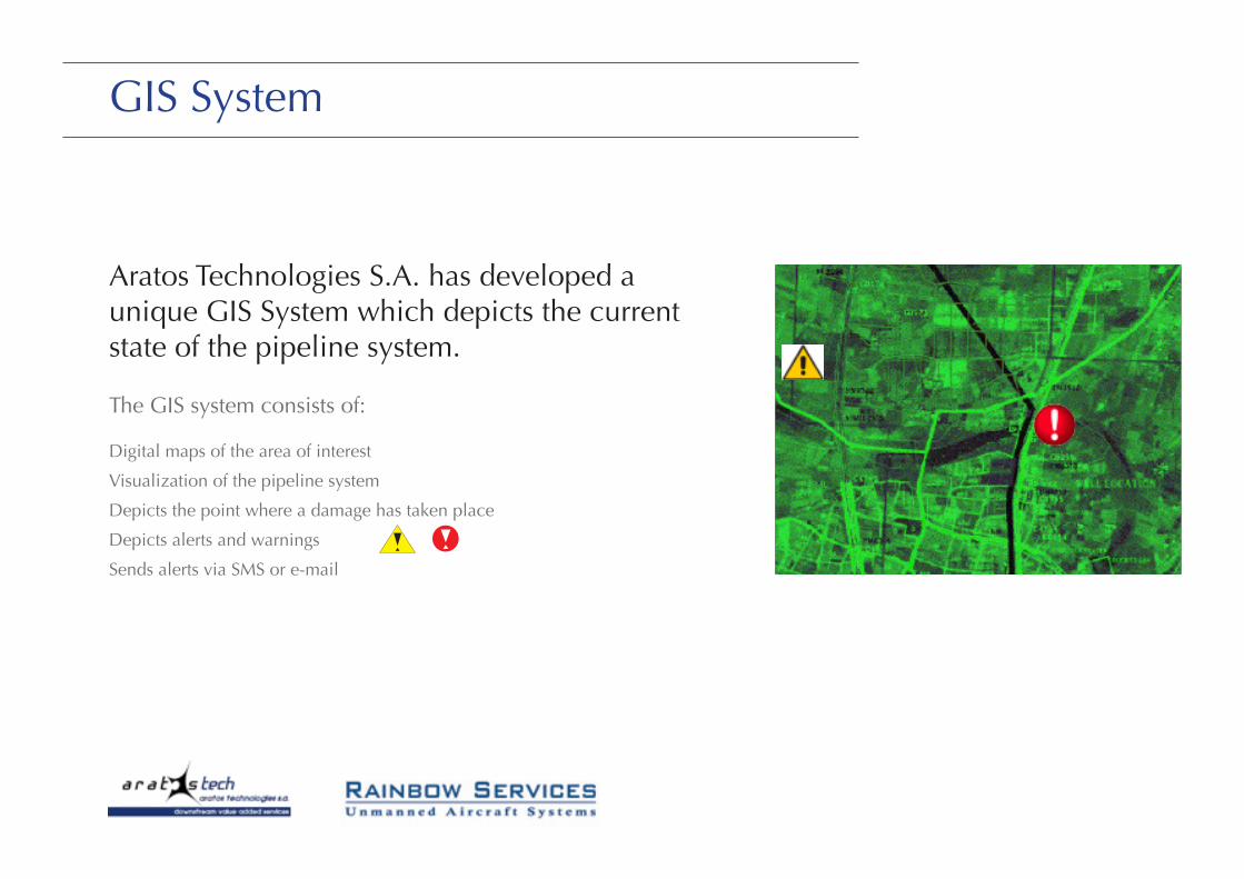
GIS System
Aratos Technologies S.A. has developed a uniqueGIS System which depicts the current state of thepipeline system.
The GIS system consists of:
-Digital maps of the area of interest
-Visualization of the pipeline system
-Depicts the point where a damage hastaken place
-Depicts alerts and warnings
-Sends alerts via SMS or e-mail
Processing of satellite images
Aratos Technologies S.A. has also developedsoftware for the processing of the satellite imageswhich have been received.
Specifically:
-Processing in different spectral bands(visible, infrared, thermal, etc.)
Processing of satellite images
Aratos Technologies S.A. has also developedsoftware for the processing of the satellite imageswhich have been received.
Specifically:
-Processing in different spectral bands(visible, infrared, thermal, etc.)

Characteristics
Aratos Pipeline Surveillance System uses:
High-Resolution Satellite data and processing of satellite images
UAS Unmanned Aircraft Systems for real time monitoring of the pipeline system at close range
Characteristics
Aratos Pipeline Surveillance System uses:
• High-Resolution Satellite data and processing ofsatellite images
• UAS for real time monitoring of the pipelinesystem at close range
Characteristics
Aratos Pipeline Surveillance System uses:
• High-Resolution Satellite data and processing ofsatellite images
• UAS for real time monitoring of the pipelinesystem at close range

Services
Aratos Pipeline Surveillance System offers:
GIS system for the visualization of the pipeline systems
UAS Unmanned Aircraft Systems for real-time monitoring
Near real-time satellite images
Software for the processing of satellite images
Alerts
Detection of damages
Monitoring of earthquake activity
GIS System
Aratos Technologies S.A. has developed a unique GIS System which depicts the current state of the pipeline system.
The GIS system consists of:
Digital maps of the area of interest
Visualization of the pipeline system
Depicts the point where a damage has taken place
Depicts alerts and warnings
Sends alerts via SMS or e-mail
GIS System
Aratos Technologies S.A. has developed a uniqueGIS System which depicts the current state of thepipeline system.
The GIS system consists of:
-Digital maps of the area of interest
-Visualization of the pipeline system
-Depicts the point where a damage hastaken place
-Depicts alerts and warnings
-Sends alerts via SMS or e-mail

Satellite Data
Aratos Pipeline Surveillance System monitors the area of interest by using near real time satellite images and data of high resolution.
Specifically:
Receives satellite images of high resolution (1-2 m)
Monitors environmental changes
Monitors current weather conditions
Creates land cover maps
Satellite Data
Aratos Pipeline Surveillance System monitors thearea of interest by using near real time satelliteimages and data of high resolution.
Specifically:
-Receives satellite images of highresolution (1-2 m)
-Monitors environmental changes
-Monitors current weather conditions
-Creates land cover maps

Processing of satellite images
Aratos Technologies S.A. has also developed software for the processing of the satellite images which have been received.
Specifically:
Processing in different spectral bands (visible, infrared, thermal, etc.)
Image operation in different bands is essential in pipeline monitoring
Every band can give different kind of information
The combination of this information is the key for a reliable monitoring of the pipeline system
Our software uses this information in order to predict a possible damage or detect anything goes wrong
Processing of satellite images
Aratos Technologies S.A. has also developedsoftware for the processing of the satellite imageswhich have been received.
Specifically:
-Processing in different spectral bands(visible, infrared, thermal, etc.)
Processing of satellite images
Aratos Technologies S.A. has also developedsoftware for the processing of the satellite imageswhich have been received.
Specifically:
-Processing in different spectral bands(visible, infrared, thermal, etc.)

UAS Unmanned Aircraft Systems
Aratos Pipeline Surveillance System monitors the area of interest by using UAS in future cooperation with Rainbow ServicesUAS are easily controlled and can fly in low altitude
Specifically:
UAS carry a special camera which detects areas of high temperature (e.g in case of a leakage)
The operator can use the camera in order to monitor the area from his office
UAS Unmanned Aircraft Systems
•Aratos Pipeline Surveillance System monitors thearea of interest by using UAS in future cooperationwith Rainbow Services
•UAS are easily controlled and can fly in low altitude
Specifically:
-UAS carry a special camera whichdetects areas of high temperature (e.gin case of a leakage)
-The operator can use the camera inorder to monitor the area from his office

UAS Unmanned Aircraft Systems
UAS are today emerging as highly effective tools for confronting pipeline monitoring
Moreover:
Oil and gas leaks show up well in infrared because of the temperature differences between the fluid and the soil
The special camera reveals the presence of thieves
UAS Unmanned Aircraft Systems
UAS are today emerging as highly effective tools forconfronting pipeline monitoring
Moreover:
-Oil and gas leaks show up well ininfrared because of the temperaturedifferences between the fluid and thesoil
-The special camera reveals thepresence of thieves

Alerts and Warnings
Aratos Pipeline System is an intelligent system. It gathers the satellite and UAS data and takes decisions about the severity of a situation
Moreover:
Depicts the points of damage on the digital maps of the GIS System
Uses different colors depending on the severity
Gives possible causes and solutions
Sends alerts via sms or e-mail
Alerts and Warnings
Aratos Pipeline System is an intelligent system. Itgathers the satellite and UAS data and takesdecisions about the severity of a situation
Moreover:
-Depicts the points of damage on thedigital maps of the GIS System
-Uses different colors depending on theseverity
-Gives possible causes and solutions
-Sends alerts via sms or e-mail
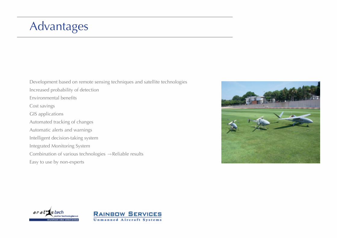
Advantages
Development based on remote sensing techniques and satellite technologies
Increased probability of detection
Environmental benefits
Cost savings
GIS applications
Automated tracking of changes
Automatic alerts and warnings
Intelligent decision-taking system
Integrated Monitoring System
Combination of various technologies Reliable results
Easy to use by non-experts

ARATOS TECHNOLOGIES S.A.93, Riga Feraiou str, Patras 26221, Greece
Office: +30 2610 242670Fax: +30 2610 242671Mail: [email protected]: www.aratos.gr
RAINBOW SERVICES – Unmanned Aircraft SystemsRyf 65, 3280 Murten, Switzerland
Office: +41 (0) 32 652 00 42Fax: +41 (0) 32 652 00 41Mobile: +41 (0) 79 250 47 44Mail: [email protected] Web: www.uasystems.com
Processing of satellite images
Aratos Technologies S.A. has also developedsoftware for the processing of the satellite imageswhich have been received.
Specifically:
-Processing in different spectral bands(visible, infrared, thermal, etc.)