AQUATIC SPECIES AND HABITATS - US Forest … areas (RHCAs) to maintain ecologi-cal functions and...
14
101 AQUATIC SPECIES AND HABITATS T he status of aquatic ecosystems in the Basin is influenced by both natural and human processes. The geologic and geomorphic processes described earlier formed and continue to affect the Basin. In concert with the underlying physical environment, these processes establish the template and constrain the successional pathways for aquatic habitats and their associated commu- nities. Similarly, natural fluctuations in the marine environment from variation in atmospheric and ocean circulation patterns influence the pro- ductivity of anadromous fish stocks and may tem- porarily mask changes in freshwater habitats. Aquatic analyses took place at the subbasin, watershed, and subwatershed level (figure 10). There are 164 subbasins in the project area, aver- aging just under 900,000 acres. The 2,562 water- sheds average about 56,000 acres, while the 7,467 subwatersheds average about 19,000 acres. Results of survey information and tests of rela- tions among habitat features, landscape features, and disturbance variables reinforce the evidence that streams within the assessment area have been significantly affected by human activities. Re- sources affected include both riparian vegetation and instream habitat. Water Quality The U.S. Environmental Protection Agency estimates overall water quality impairment within the Basin. This estimate appears to be modest in comparison to total length of streams within the assessment area (table 5). Because these estimates are based on existing and accessible data from local state and Federal monitoring programs, they likely do not reflect the actual extent and distri- bution of impairment. Most streams in the region are now fully or over-appropriated; irrigation is the primary off-stream use of water in the Basin. Riparian Areas Riparian vegetation is a critical component of aquatic ecosystem integrity. A Basin-wide analysis of riparian vegetation found significant changes, including a widespread decline in shrublands in the riparian zones. Shrublands predominantly shifted to forests and herblands through The integrity of riparian vegetation and its extent along rivers has been changed and fragmented throughout the Basin in response to forest conversion and streamside disturbance.
Transcript of AQUATIC SPECIES AND HABITATS - US Forest … areas (RHCAs) to maintain ecologi-cal functions and...

101
AQUATIC SPECIES ANDHABITATS
The status of aquatic ecosystems in the Basinis influenced by both natural and humanprocesses. The geologic and geomorphic
processes described earlier formed and continue toaffect the Basin. In concert with the underlyingphysical environment, these processes establish thetemplate and constrain the successional pathwaysfor aquatic habitats and their associated commu-nities. Similarly, natural fluctuations in themarine environment from variation in atmosphericand ocean circulation patterns influence the pro-ductivity of anadromous fish stocks and may tem-porarily mask changes in freshwater habitats.
Aquatic analyses took place at the subbasin,watershed, and subwatershed level (figure 10).There are 164 subbasins in the project area, aver-aging just under 900,000 acres. The 2,562 water-sheds average about 56,000 acres, while the 7,467subwatersheds average about 19,000 acres.
Results of survey information and tests of rela-tions among habitat features, landscape features,and disturbance variables reinforce the evidencethat streams within theassessment area have beensignificantly affected byhuman activities. Re-sources affected includeboth riparian vegetationand instream habitat.
Water QualityThe U.S. Environmental Protection Agency
estimates overall water quality impairment withinthe Basin. This estimate appears to be modest incomparison to total length of streams within theassessment area (table 5). Because these estimatesare based on existing and accessible data fromlocal state and Federal monitoring programs, theylikely do not reflect the actual extent and distri-bution of impairment. Most streams in the regionare now fully or over-appropriated; irrigation isthe primary off-stream use of water in the Basin.
Riparian AreasRiparian vegetation is a critical component of
aquatic ecosystem integrity. A Basin-wide analysisof riparian vegetation found significant changes,including a widespread decline in shrublands inthe riparian zones. Shrublands predominantlyshifted to forests and herblands through
The integrity of riparian vegetation and its extentalong rivers has been changed and fragmentedthroughout the Basin in response to forestconversion and streamside disturbance.

102
Figure 10—An example of hydrologic hierarchy from subwatersheds to subbasins.

103
succession or disturbance. Forests, woodlands,and herblands increased in area or stayed approxi-mately the same. Cottonwood, aspen, and willow,typically riparian-associated species known to havesignificantly declined, are included in the forestclass but are likely masked by the dominance ofother species in this class. There was a significant
decrease of these cover types in the Snake Head-waters and Columbia Plateau. Significant increasesin woodlands—attributed to shrubland conver-sion to juniper stands—occurred in the NorthernGreat Basin, Blue Mountains, and ColumbiaPlateau. The integrity of riparian vegetationand its extent along rivers has been changed and
Table 5—Water quality impaired waters reported by the states and the Environmental Protection Agency as miles of streamsand rivers in the portions of states within the Interior Columbia Basin Ecosystem Management Project assessment area.
1The Utah Department of Environmental Quality reports no impaired streams or rivers within the project area in Utah.
Sediment/siltation/
Total Any Temperature Nutrient turbidity Flowstream miles impairment impairment impairment impairment impairment
Oregon (1994/96) 75,186 8,123 7,358 280 948 1,263
Forest Service 2,528 2,464 0 320 134
BLM 646 570 49 65 78
Washington (305b) 49,150 3,962 2,815 33 No Data 2,551
Forest Service 578 204 0 No Data 446
BLM 26 14 0 No Data 16
Idaho (303d) 98,984 10,024 2,632 3,459 8,812 2,714
Forest Service 3,000 455 306 2,568 478
BLM 1,350 513 391 1,187 506
Montana (303d) 31,317 3,912 1,051 1,138 3,034 1,791
Forest Service 1,360 271 99 1,053 556
BLM 70 20 10 56 45
Wyoming (303d) 4,785 71 0 0 46 0
Forest Service 39 0 0 35 0
BLM 2 0 0 2 0
Nevada (303d) 6,835 175 161 14 0 0
Forest Service 11 1 9 0 0
BLM 48 48 0 0 0
TOTALSAll States 266,257 26,266 14,017 4,922 12,840 831
Forest Service 1 7,515 3,395 414 3,976 1,431
BLM 2,142 1,164 450 1,311 646

104
fragmented throughout the Basin in response toforest conversion and streamside disturbance.
The sufficiency of interim riparian habitatconservation areas (RHCAs) to maintain ecologi-cal functions and prevent undesirable cumulativeeffects is a subject of both social and scientificdebate. Interim RHCAs in the range of anadro-mous fishes and bull trout are prescribed at 300-foot-minimum widths for fish-bearing streams tomaintain stream function and prevent sedimentinputs from nonchannelized sources. A reviewof the literature indicates that this width is likelysufficient to provide for most riparian functionswith a margin for error depending on the inten-sity and extent of activities within a RHCA. Thelikelihood of disturbance resulting in discernibleinstream effects increases as adjacent slopes becomesteeper. Thus, greater protective measures to pro-tect or rehabilitate riparian function and structureon steeper slopes may be required to prevent orreduce in-stream effects.
Taken in aggregate, management of stream andriparian systems on forestlands is more restrictiveand ecologically more effective than managementof riparian areas where agriculture and urban orindustrial land uses are dominant. No state with-in the Basin has enacted an agricultural practicesact explicitly protecting riparian vegetation. If thegoal is to ensure survival of salmon and many na-tive fishes in the long term, improved protectionof riparian areas in agricultural lands is essential.
Dams and DiversionsConstruction of dams and reservoirs and their
complex effects on migration is an importantthreat to the persistence of salmon and steelheadtrout within the Basin. Construction of largedams began about 1900, and has since greatlyreduced the range of migrat-ing fish. Today there are atleast 1,239 large dams inthe assessment area, eachwith storage capacity inexcess of 62,000 cubicmeters. The total, includ-
ing small dams, could be several times larger.Most of the thousands of small dams in the Basindo not have fish passage facilities, yet the fullextent to which these dams impede migration oraffect spawning and rearing habitats of fishes hasnot been documented. Even with fish passagefacilities, detrimental effects from dams occur asa result of direct mortality of juveniles in turbinesand bypass systems and indirect mortality owingto physiological stress, increased susceptibility topredators, and the inability to find routes arounddams and through slack water.
Although much of the highest-quality habitatfor these anadromous fish probably remains inthe Central Idaho Mountains, no strong popula-tions persist there largely due to passage mortalityin migration corridors. These corridors provide acritical link maintaining the complex life historiesof other species as well. For example, non-anadromous species that retain migratory life-his-tory patterns such as bull, redband, Yellowstonecutthroat, and westslope cutthroat trout maymove repeatedly between small rivers andheadwater streams.
RoadsThe effects associated with roads reach
beyond their direct contribution to disruptionof hydrologic function and increased sedimentdelivery to streams. Roads provide access, andthe activities that accompany access magnifythe negative effects on aquatic systems beyondthose solely from roads themselves. Strongpopulations of fish are present in some roadedsubwatersheds. This relationship between pop-ulation status and roads requires more investi-gation to be fully understood.
Increasing road density is correlated with decliningaquatic habitat conditions and aquatic integrityand is associated with declines in the status of fournon-anadromous salmonid species.

105
Increasing road density is correlated with de-clining aquatic habitat conditions and aquatic in-tegrity and is associated with declines in the statusof four non-anadromous salmonid species. Thediscussion of the relation of roads to fishes ofteninvolves three themes: (1) the belief that road-building practices have improved in the last de-cade to the point we should not worry about theeffects of roads on aquatic systems; (2) the legacyof past road building is so vast and road mainte-nance budgets so low that the problems will bewith us for a long time; and (3) the belief that thecorrelation of road density to fish habitat and fishpopulation is not strong.
An intensive review of the literature concludesthat increases in sedimentation are unavoidableeven using the most cautious roading methods.Roads combined with wildfires accentuate the risk
from sedimentation. The amount of sedimenta-tion or hydrologic alteration from roads thatstreams can tolerate before there is a negativeresponse is not well known. It is not fully knownwhether building roads to reduce fire risk causesgreater risk to aquatic systems than realizing thepotential risk of fire.
In addition, the ability of the Forest Serviceand BLM to conduct road maintenance has beensharply reduced because of declining budgets.This is resulting in progressive degradation of roaddrainage structures and a potential increase in ero-sion. Most problems are with older roads locatedin sensitive terrain and roads that have been essen-tially abandoned but are not adequately config-ured for long-term drainage.
While roads pose many risks to ecosystem functioning, they provide benefits to humans through access for recre-ation and other land uses.

106
PoolsAlong with the loss of riparian vegetation,
human activities have combined to create majordecreases in pool habitat. Pools provide manykey functions, including rearing habitat for juve-nile fish, resting places, overwintering areas, andrefuges from floods, drought, and extremetemperatures.
Pool frequency (large pools and all pools) isinversely correlated with road density and man-agement intensity. The magnitude of decreasesin deep pools is substantial and extensive acrossthe Basin. Most unmanaged streams either haveretained pools or have improved pool habitat dur-ing the last 55 to 60 years.
A factor likely to be important in controllingpool frequency in the Basin is the abundanceof instream wood. Wood effectively stabilizeschannels, influences sediment routing, provides amajor component of the instream organic matter,provides cover for fish and habitat for inverte-brates, and increases overall channel complexity.Protecting sources of instream wood for streamsis important: there is not muchwood to begin with, it plays acritical role for pool formationand habitat conditions, andwood frequency is sensitive tomanagement practices.
Another important aspect ofhabitat quality that apparentlyis influenced by management isthe amount of fine sediment(sediment less than 6 mm) onchannel beds. Road densitysignificantly affects surfacefines and corroborates the linkbetween forest managementpractices and channel sedimentcharacteristics.
Status andDistribution of Fishes
A total of 142 fish taxa were reported withinthe Basin. Fishes were considered at three levelslisted in order of increasing detail: (1) fish speciesassemblages, from which richness and diversityindices were calculated; (2) 38 taxa consideredsensitive, threatened, endangered, or of specialconcern; and (3) key salmonids [bull, westslopecutthroat, Yellowstone cutthroat, and redbandtrout; steelhead trout; and ocean-type (age-0migrant) and stream-type (age-1 migrant) chinooksalmon]. This analysis was based on both a
The composition, distribution, andstatus of fishes within the Basin isvery different than it washistorically.
The bull trout is one of seven key salmonids in the Basin.

107
The Metolius River in central Oregon has clear, cold water flowing from springs that help create excellenthabitat for Bull trout.
summary of known distributions and the predic-tion of distributions and status for select speciesthroughout the entire assessment area and wassupported by information collected through morethan 140 biologists working throughout the region.
Aquatic habitat fragmentation (impassableobstructions—including dams, temperatureincreases, and water diversion) and simplification(channelization, removal of woody debris, channelbed sedimentation, removal of riparian vegetation,and water flow regulation) have resulted in a lossof diversity within and among native fish pop-ulations.
The composition, distribution, and status offishes within the Basin is very different than it washistorically. Some forms are extinct and manyothers, especially anadromous fish, are extirpatedfrom large portions of their historical range.
Although several of the key salmonids remain dis-tributed through much of their historical ranges(notably the cutthroat trouts and interior redbandtrout), declines in abundance, the loss of impor-tant life histories, local extinctions, and fragmen-tation and isolation of high-quality habitats areapparent (maps 15 and 16). Wild chinook salmonand steelhead trout are approaching extirpation ina major part of the remaining distribution.
With the exception of the Central IdahoMountains, Snake Headwaters, and perhaps theNorthern Cascades, most of the important areasfor the key salmonids exist as patches of scatteredwatersheds. Many of these important watershedsare associated with high-elevation, steep, andmore erosive landscapes. These may be moreextreme or variable environments contributingto higher variability in the associated populations

108
Map 15—Historic key salmonid presence.

109
Map 16—Current key salmonid presence.

110
Map 17—Aquatic strongholds and low road densities.

111
and higher sensitivity to watershed disturbances.Even with no further habitat loss the fragmenta-tion and isolation may place remaining popula-tions at risk. Risks could be aggravated withfurther development. The distribution of steel-head trout, for example, has decreased from his-torical range and known or predicted strongholdsare few and far between.
Although less is known about the rare andsensitive fish taxa than the seven key salmonids,analyses of existing distribution and reviews ofavailable literature provide insights about com-mon threats and appropriate management needs.Many of these taxa occur in isolated areas of theColumbia River basin, in isolated subbasins ofthe Great Basin, or are restricted to the upperKlamath Basin. They typically occur in subbasinswith only 1 or 2 native fish species present and invery restricted areas, often occupying 1 or 2 smallhabitat patches within subwater-sheds (averaging 8,000 hectares insize). Consequently, broad- or mid-scale assessments that focus on highnative species diversity may notadequately describe their distri-butions.
Some 15 previous efforts toidentify special emphasis water-sheds for conservation of aquaticresources and ecosystem functionin the Basin were examined to address whetherhabitat criteria or population presence and statusare better indicators for such special fish emphasiswatersheds. Fish population strength was evaluat-ed to identify the best remaining habitats withinthe Basin by focusing on subwatersheds with des-ignated strong populations of seven key salmo-nids. This approach has the distinct advantage ofrecognizing the biological building blocks neces-sary to maintain and rehabilitate fish populationsin the Basin. More than 27 percent of FS- andBLM-administered lands in the Basin containstrongholds (40 percent of Forest Service and 4percent of BLM). These subwatersheds containlarge areas of unroaded land (map 17).
Implications for EcosystemManagement
Although much of the native ecosystem hasbeen altered, core areas remain for rebuilding andmaintaining functional native aquatic systems.Even though they are reduced in numbers anddistributions, native trouts remain some of themost widely distributed taxa within the Basin.This suggests that although serious problems exist,particularly in the larger rivers and in the low-ele-vation agricultural and rangelands, the situation issomewhat better in the forested lands. Condi-tions remain best in areas that have experiencedthe least human-caused disturbance. Most of theareas exhibiting high-aquatic integrity fall withinforested areas, with the exception of areas inher-ently high in native-species richness near thesouthern edge of the Basin.
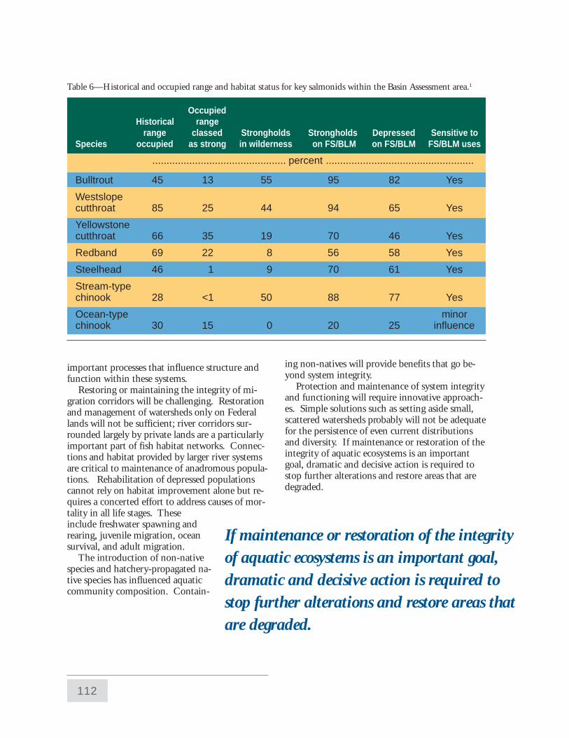
The largest areas of contiguous watersheds sup-porting strong populations of key salmonids areassociated with the major river subbasins found inthe Central Idaho Mountains, the Snake Head-waters and the Northern Cascades. Importantbut more restricted areas are also found in theBlue Mountains, Upper Clark Fork and theNorthern Glaciated Mountains. Each of the keysalmonids supported some known or predictedstrong populations (table 6).
The core for maintaining and restoring muchof the biological diversity associated with fishesstill exists. Conservation and restoration of im-portant habitats for key salmonids could providehabitat for associated species and will sustain
Although much of the native ecosystem hasbeen altered, core areas remain for rebuildingand maintaining functional native aquaticsystems.
112
OccupiedHistorical range
range classed Strongholds Strongholds Depressed Sensitive toSpecies occupied as strong in wilderness on FS/BLM on FS/BLM FS/BLM uses
............................................... percent ....................................................
Bulltrout 45 13 55 95 82 Yes
Westslopecutthroat 85 25 44 94 65 Yes
Yellowstonecutthroat 66 35 19 70 46 Yes
Redband 69 22 8 56 58 Yes
Steelhead 46 1 9 70 61 Yes
Stream-typechinook 28 <1 50 88 77 Yes
Ocean-type minorchinook 30 15 0 20 25 influence
important processes that influence structure andfunction within these systems.
Restoring or maintaining the integrity of mi-gration corridors will be challenging. Restorationand management of watersheds only on Federallands will not be sufficient; river corridors sur-rounded largely by private lands are a particularlyimportant part of fish habitat networks. Connec-tions and habitat provided by larger river systemsare critical to maintenance of anadromous popula-tions. Rehabilitation of depressed populationscannot rely on habitat improvement alone but re-quires a concerted effort to address causes of mor-tality in all life stages. Theseinclude freshwater spawning andrearing, juvenile migration, oceansurvival, and adult migration.
The introduction of non-nativespecies and hatchery-propagated na-tive species has influenced aquaticcommunity composition. Contain-
ing non-natives will provide benefits that go be-yond system integrity.
Protection and maintenance of system integrityand functioning will require innovative approach-es. Simple solutions such as setting aside small,scattered watersheds probably will not be adequatefor the persistence of even current distributionsand diversity. If maintenance or restoration of theintegrity of aquatic ecosystems is an importantgoal, dramatic and decisive action is required tostop further alterations and restore areas that aredegraded.
If maintenance or restoration of the integrityof aquatic ecosystems is an important goal,dramatic and decisive action is required tostop further alterations and restore areas thatare degraded.
Table 6—Historical and occupied range and habitat status for key salmonids within the Basin Assessment area.1

113
While watershed protection is an effectivemanagement approach, evidence suggests that sys-tem integrity can be maintained in some inten-sively managed areas. It is unclear, however,whether intensively managed areas with high in-tegrity are anomalies, regions where the effects onstreams lag behind the changes on land, or are ar-eas where intensive management and fish can co-exist.
Additional research will help to design manage-ment strategies to accomplish fish and habitatgoals. The collective knowledge of status, distri-bution, and habitats for fishes is incomplete. Ex-isting knowledge reflects the historical focus offish management and research agencies on pro-duction and yield, recreational fishing opportuni-ty, and high-profile species rather than on bioticintegrity or species conservation. Sampling meth-odologies are poorly developed, inventories are in-complete, and reference standards are virtuallynon-existent. The development of consistent, reli-able, large-scale species inventories will be criticalfor long-term management and evaluation ofaquatic ecosystems.
Field experiments can be developed to provideinformation on the spatial dimensions (that is,width, length, depth, space and continuity) of ri-
parian buffer zones necessary to achieve single andmultiple ecological and/or social objectives as wellas how well they continue to function throughtime.
Three types of studies can contribute to theevaluation of hydrologic and geomorphic distur-bance effects. First, field surveys are needed to as-sess the effect of historical events such as fires andlarge floods. Second, intensive, opportunistic sur-veys could be undertaken during and followingthese rare events. Third, the resilience of riparianand aquatic ecosystems to changes in the magni-tude and frequency of extreme events could betested using human-caused events (such as regu-lating levels of dams, reservoirs, and irrigationwithdrawal).

114