AQU IF ERP OTC N S CL IN TO, E U - CT ECO Homecteco.uconn.edu/maps/town/apa/apa_Clinton.pdf ·...
1
! n ! n ! n ! n ! n ! Ã ! Ã ! n ! n ! n ! n ! n ! n ! Ã ! n ! n ! n ! o ! n ! n ! n ! n ! n Winthrop Ivoryton Ridgewood East River Kelseytown Pond Meadow Centerbrook Grove Beach Harbor View Middle Beach North Madison Seaview Beach Clinton Beach Post Hill Book Hill Toby Hill Mount Tom Bushy Hill Tower Hill Buell Hill Mares Hill The Ledges Pine Ledge Duck Island Ingham Hill Money Point Walnut Hill Salt Island Kelsey Hill Cedar Knoll Tuxis Island Murdock Hill Kelsey Point Cedar Island Stone Island Cedar Island Spencer Hill Grass Island Hammock Point Chipman Point Webster Point Chestnut Hill Willard Island Clapboard Hill Hogshead Point Cranberry Hill Roast Meat Hill Faulkner Island Old Kelsey Point Hammonasset Point Grove Beach Point Podunk Great Plain Rattling Valley Hill Menunketesuck Island Grove Beach Circle Beach Middle Beach Chalker Beach Chapman Beach Clinton Beach Stannard Beach Esposito Beach Surf Club Beach Quotonset Beach Pent Road Beach East River Beach East Wharf Beach West Wharf Beach Hammonasset Beach Clinton Town Beach Wesbrook Town Beach Hog Pond Hog Pond Dee Pond Star Lake Mill Pond Lord Pond Hill Pond Drop Pond Deer Lake Post Cove Ward Brook Ward Brook Toms Creek Pond Brook Neck River Neck River Neck River Hurd Brook East River East River Deep River Deep River Burr Brook Tuxis Pond Trout Pond Ryans Pond Pefes Pond North Pond Horse Pond Horse Pond Dolan Pond Bushy Pond Brook Pond Pratt Cove Mine Swamp Trout Brook Simon Brook Plane Brook Hagar Creek Fence Creek Falls River Falls River Bushy Brook Rogers Pond Kroopa Pond Kelsey Pond Indian Lake Goulds Pond Foster Pond Dudley Pond Pond Meadow Cedar Swamp Cedar Swamp Indian River Indian River Indian River Dudley Creek Bailey Creek Wrights Pond Whedons Pond Vincent Pond Ellefson Dam Tiffany Pond Shailer Pond Shailer Pond Rintoul Pond Ortners Pond McVeagh Pond Johnson Pond Hummers Pond Crystal Lake Boulder Lake Tiffany Brook Roaring Brook Hammock River Gatchen Creek Old Mill Pond Madison Lakes Keyboard Pond Ivoryton Pond Dennison Pond Comstock Pond Chapmans Pond Bartlett Pond Oil Mill Brook Hog Pond Brook Burdicks Brook Upper Millpond Ward Brook Dam Schumanns Pond Schreeder Pond Post Hill Pond Game Farm Pond Cranberry Pond Birch Millpond Clinton Harbor Salt Works Bay Patchogue River Tower Hill Lake Pratt Reed Pond Bushy Hill Pond Spring Lot Brook Summer Hill Pond Stevenstown Pond Murray Pond No 3 Murray Pond No 2 Murray Pond No 1 Westbrook Harbor Pond Meadow Brook Hammonasset River Hammonasset River Hammonasset River Dowd Hollow Brook Cold Spring Brook Pequot Swamp Pond Old Scroggie Pond Duck Island Roads Indiantown Harbor Messerschmidt Pond Menunketesuck River Menunketesuck River Menunketesuck River Huzzle Guzzle Brook Roads End Farm Pond Roast Meat Hill Pond Pratt Read Reservoir Kelseytown Reservoir Green Hill Road Brook Westside Cemetery Dam Hammonasset Reservoir Chatfield Hollow Brook Killingworth Reservoir West Rock Gull Rock Long Rock Crane Reef East Ledge Great Rocks The Tailings Lobster Rock Wheeler Rock Madison Reef Half Acre Rock Falkner Island Reef Chester Airport Essex Elementary Morgan High School Westbrook High School Deep River Elementary Abraham Pierson School Killingworth Elementary J Milton Jeffrey School Daniel Hand High School Westbrook Middle School Island Avenue Elementary Dr RH Brown Middle School Jared Eliot Middle School Kathleen H Ryerson School Haddam-Killingworth Middle John Winthrop Middle School Valley Regional High School Walter C Polson Middle School Lewin G Joel Elementary School Daisy Ingraham Elementary School Clinton Station Madison Station Westbrook Station I 95 US Hwy 1 Route 1 State Hwy 145 River Rd Green Hill Rd Route 81 Route 148 Governor John Davis Lodge Tpke Route 153 State Hwy 81 Cow Hill Rd Route 80 State Hwy 148 Summer Hill Rd Essex Rd State Hwy 9 Chestnut Hill Rd State Hwy 153 Boston Post Rd Opening Hill Rd Route 154 State Hwy 80 Roast Meat Hill Rd Pea Hill Rd Route 79 Elm St Nod Rd Middlesex Tpke Durham Rd Clinton Rd Branford Rd Horse Hill Rd State Hwy 154 Toby Hill Rd Horse Pond Rd Copse Rd Warpas Rd Higganum Rd Reservoir Rd Killingworth Tpke Dogwood Knls State Hwy 79 Podunk Rd Pine Orchard Rd Nortontown Rd Chester Rd Old Clinton Rd Neck Rd Ironworks Rd Pond Meadow Rd Abner Ln Airline Rd Pine Ledge Rd Cedar Swamp Rd Bushy Hill Rd Stevenstown Rd Old Toll Rd Long Hill Rd Union St Westbrook Rd Liberty St Glenwood Rd Chittenden Rd Shore Rd School House Rd Essex St Old Post Rd Beckwith Rd Schubert Rd Hoop Pole Hill Rd New Rd Bartlett Dr Route 145 Ridge Rd Warsaw St Iron Works Rd Ingham Hill Rd Bridge St Pratt Rd Main St Cedar Lake Rd Winthrop Rd Scotland Rd River St State Hwy 166 Iona Rd Kelsey Hill Rd Fort Path Rd Buck Rd Mungertown Rd Bokum Rd Lynn Rd Hammonasset Connector Spruce Ledge Rd Wildcat Rd Halls Rd Deep River Rd Clapboard Hill Rd Spencer Hill Rd Duck Hole Rd Old Nod Rd Hull Rd Seaside Ave Madison Tpke Paper Mill Rd Fox Hill Rd Fairy Dell Rd Tooley Rd Kelseytown Rd Walnut St Old Westbrook Rd Bar Gate Trl Champlin Rd Grove Beach Rd PD Hill Rd Mares Hill Rd High St Carter Hill Rd Grove St Race Hill Rd Chittenden Hill Rd Beach Park Rd Lovers Ln Ben Merrill Rd Hammock Rd Fairview Rd Squires Rd Killingworth Durham Rd Bishop Ln Island Ave Flat Rock Pl Cross Rd Bahr Rd Valley Rd Book Hill Rd Stevens Rd Pond Hill Rd Squaw Ln Warf Rd Brickyard Rd Murray Ln Cottage Rd Tower Hill Rd Dennison Rd Bunnell Bridge Rd Mill Rd Riverside Dr Hunters Trl Tanner Marsh Rd Bradley Rd Mitchel Ter Cedar Rd Hemlock Dr Ebony Ln Butter Jones Rd Laurel Ridge Trl Overbrook Rd Pettipaug Rd Shore Dr SD View Rd Harry Field Rd Wharf Rd Kirtland St Plains Rd Olde Orchard Rd Sypher Rd Cream Pot Rd Pine Dr Rattling Valley Rd Pratt Ave Randi Dr Egypt Ln Melody Ln Commerce St Cold Spring Rd Colonial Rd Nod Pl Willard Ave Osprey Cmns Spencer Plains Rd Middle Beach Rd Christina Ct Vienna Ln Elsie Ln Flintlock Rd Garnet Park Rd James Vincent Dr Sperry Dr Deer Ln Chalker Ave Firetower Rd Titus Coan Rd Spencer Hl Brush Hill Rd Wildwood Ave Quail Run Uncas Rd Fox Hill Dr Fiske Ln Orcutt Dr Blinnshed Rd Schnoor Rd Woodsvale Rd Silver Birch Ln Soundview Rd Old 79 Malabar Dr Bochim Rd Deepwood Dr Groveway Spring St Dibble Rd Acorn Rd Fish Plain Rd Nursery Ln Scotland Ave Beech Tree Rdg Ark Rd Silo Hl Kelsey Pl Wall St Jannas Ln Broadway Winterhill Rd Hickory Ln Old Rd Pleasant Valley Rd Boone Cir Witch Hazel Dr Mal-A-Bar Dr Spencer Plain Rd Forest Rd Old Mail Trl Wolf Hollow Ln Pepperbush Dr Fishing Brook Rd Hemlock Ter Winds Dr Signal Hill Rd Lenore Dr Stanton Rd Waterside Ln Oak Dr Gate Rd Kenilworth Dr Lee Way Fawn Hill Rd Cherry Ln Birch Mill Trl Concord Dr Joshua Trl Parker Hill Rd Circle Dr Willow Ln Ken Rose Ter Wesley Ave Granite Hill Rd 2nd Ave Old Mine Rd Salt Island Rd Park Rd 1st St Robin Ln Boulder Trl Carol Dr Beekman Pl Lords Ln Michael Dr Saybrook Rd Hammonasset State Park Patrick Dr Oakwood Dr Colonial Dr Church Ln Shorelands Dr Carriage Dr Cinnamon Rdg Wrights Pond Rd Lake Dr Center Rd Summitt St Harbor Pkwy Stony Ln Stanwoll Hill Rd Hurd Bridge Rd Sportsman Hill Rd Railroad Ave Longshore Ln Tuxis Rd West Rd Farm Ln Harbor Ave Chapman Mill Pond Rd Seaview Ave Timberlane Dr Knollwood Dr Meadow Rd Buell Hill Rd Straits Rd Shepherds Trl Service Road Brooks Ln Sperry Rd Falls River Dr Old Salt Works Rd Homestead Dr Princess Dr Seaford Rd Meadowlands Barn Rd Sheep Pasture Rd Bridlepath Trl 5 Field Rd Beach Ave Nutmeg Ln Pepperidge Trl Hilldale Trl Fawn Hill Dr Pine Knls Foster Ln Caughlin Rd Laurel Crest Rd Johnson Ln Pearl St Horseshoe Rd Pine Lake Rd Scenic Rd Kelsey Springs Dr Waldron Dr Anthony Ln Madison Springs Dr Hills Rd Surf Club Rd Wickford Pl Davis Dr Northwood Rd Goat Hill Rd Whitewood Rd Plymouth Rd Timber Ln Buttonball Ln Seafields Ln Eagle Ridge Dr Farm View Dr College St Stone Hedge Rd Keith Cir Comstock Ave Rolling Meadow Rd Blake St Evergreen St Green Acres Rd Boston St Pinnacle Ln Causeway Post Ave Kings Grant Rd Kingfisher Ln Oak Ridge Dr Read St Hammonasset Pt Puritan Ln Pequot Park Rd Diamond Rd Maplewood Dr Beaver Dam Trl Woodland Dr Burgis Ln Madison Ave Webster Point Rd Aviation Dr North St Indian Dr Fairview Dr Bluff Ave Pritchett Dr Partridge Ln Genesee Ln Blueberry Hill Reserve River Ln Hillside Ter Tulip Tree Dr Twilight Dr Blaine Ave Fawn Brook Cir Kitteridge Hill Rd Windsor Ct Bridge Rd Winding Rd Hotchkiss Ln Cedar Island Ave Watrous Rd White Cedar Dr Break Neck Hill Rd Granby Dr Harvey Dr Highland Dr Ivory St Earl St High Hill Cir Scenic View Dr Walnut Hill Rd Allison Dr Acorn Dr Fox Run Rd Cow Pen Hill Rd Highland Ter East Rd Riverview Ave Houperts Way Pointina Rd Riverview Dr Davies Cir Windsor Ln Swamp Ledge Rd Nod Ln Ely Ln Den Hollow Rd Old Kelsey Point Rd Meadow Lark Ln Maple Hl Forest Hills Dr Dover Ln Swan Lake Trl Lincoln Rd Jefferson Park Rd Lynne Rd Beach Rd Nutmeg Dr Fife Ct Lafata Ln Old Dobbin Ln Stone Rd Windy Hill Rd Neptune Ave Woods Ln Beaver Pond Rd Woodland Rd Tamarac Dr Victoria Ln Dogwood Dr Cedar Dr Riverview Rd Vincent Ct Stonewall Ln Lobb Ln Fawn Trl Johnson Pond Ln Morgan Park Conestoga Dr Maple Ave Day Dr Beaver Dam Rd Northwinds Dr Squaw Brk Mallard Ln Sylvan Ter Janes Ln Pinewood Trl Sunny Hill Dr Strawberry Hill Rd Edgewood Dr Jenifer Ln Blake Ave Longate Rd Old Farms Rd Circle Beach Rd Cedar St Heatherwood Dr Winthrop Hill Rd Buffalo Bay Shailer Pond Rd Canary Ln Dairy Hill Rd Settlers Ln Birch Mill Rd Happy Acres Rd Bellstone Ave Quarry Hill Rd Cedarcroft Dr Deer Ridge Rd Margo Ln Currycross Rd Allen Rd Dump Rd Laconia Dr Rebecca Ln Davis Farm Rd Lockwood Dr Chord Ln Hillcrest Dr Burcam Dr Founders Rd Whitman Rd Wellsweep Dr Bearhouse Hill Rd Whittlesey Brook Rd Wyndy Brook Ln Town Park Heritage Cir Half Penny Ln Trailwood Dr Cambridge Dr Linnea Ln Clarkson Ln Michele Ln Indian Trl Kimberly Ln Godman Rd Sandlewood Dr Glen Grove Rd Green Meadow Dr Wood Pond Ln Crestview Dr Bridle Path Ln Adirondack Ln Industrial Park Rd White Birch Rd Lochbourne Dr Fox Run Ln Hathaway Ln Brookview Ter Orchard Path Townwoods Rd Amber Trl Oakledge Dr Lake Laconia Dr Alden Dr Park Ave Vista Ter Ortner Dr Christina Ln Nathans Ln Chapman Ave Ellen Ln Forest Glen Rd Glenwood Dr Christopher Ln Fox Hollow Rd Walkley Ml Hopper Rd Old Forge Rd Sheffield Ln White Oak Dr Waterbury Ave Elmwood Way Everett Ln Soundview Ave Deer Run Rd Chatfield Ridge Rd Glenn Rd Ridgewood Ave Marian Ln Oakwood Ln Oak Ave Milano Pond Dr Windermere Way Kaiser Ln Meadow Point Rd Maple Leaf Dr White Pine Ln Milestone Ln Taylor Ridge Rd Orchard Park Rd Oak Hill Dr Wilshire Rd Fairfield Rd Whedon Ln Vine Rd Sachem Cmn Melody Rdg Hartford Ave Samson Rock Dr Nod Ct Stonehedge Ln Old Deep River Tpke Trolley Ave Conklin Ave Brainard Rd Pleasant Hl Rachel Ln Elm Ave Sugar Hill Rd Hampshire Rd Esico Ln Bushnell Ln Rustic Ln Country Village Ln Chester Vlg Whittemore Pl Hemlock Hill Rd Eastwood Dr Monroe Ln Hide A Way Nod Hill Rd Sunnybrook Ln Rockledge Dr Edgewood Ave Willow Way Tamarac Trl Skytop Dr Robin Ridge Dr Windward Ln Aileen Dr Copse Hill Trl Georgetown Cir Hunters Ridge Dr Liberty Ln Belmont Ave Laurel Wood Dr Pond View Ln Holly Dr Stacey Ln Beechwood Dr Gull Rock Rd Oak Ln Fence Creek Dr Aspen Dr Beechwood Ln Salem Rd Surrey Ridge Rd Carmel Ct Corinth Dr Nature Trl Highview Rd Winterberry Cir Michelle Ln Glen Ln Foxwood Rd Edinburgh Ln Hunters Path Dudley Ln Horse Shoe Dr Central Ave Owl Hollow Ln Maplewood Ln Marine Ave Running Brook Dr Highfield Rd Rosemary Ln Cooks Ln Osprey Cir PD Lily Rd Canborne Way South Incarnation Rd Overlook Dr Lucy Ln Baxter Rd Twin Oaks Ln Legend Hill Rd Tower Hill Lake Rd Economy Dr Captains Dr Old Boston Post Rd Kingsbridge Way Alex Dr Stepping Stone Ln Jamaica Rd Bridge Ln Pheasant Ln Martin Dr Dudley Towne Rd Wellsweep Ln Princess Pine Ln Britton Ln Roberts Rd Campus Dr Manzoni Farm Dr Woodsedge Ln Mohawk Dr Van Dyke Ln Oakridge Dr Caleb Ct Loop Rd Pallenberg Dr Grouse Ct Copperfield Dr Qry Ledge Striper Ave Sandy Brook Rd Eagle Meadow Dr Cheney St White Oaks Ln Milo Dr Hilltop Dr Stokes Ave Kristen Way Oscela Trl Mels Rd Minnow Ln Pine Orchard Ln Meadowview Rd Rivers Edge Rd Laurie Ln Daffodil Hill Rd Nutmeg Cir Sterling Dr Antonie Rd Rosenblad Dr Sussex Pl Patchogue Pl Town Clerk Ln Dogwood Knoll Rd Toffy Ln Thames Way Park Ln Essex Ct Woodbury Dr Woodbury Rd Little Rd Meadow Ln Paper Mill Dr Green Acres Dr Pilots Point Dr Knothe Hill Rd Golf Links Rd Old Cambridge Ct Dowd Rd Chelsea Ln Schoolhouse Ln Cherry St Hemlock Cir Hagar St Stone Fence Ln Little Hollow Rd Plymouth Ct Bundy Hl Water Company Rd Woodcock Ln Mitchel Cir Apple Way Williamsburg Cir Ridge Rd Main St Partridge Ln Neck Rd Long Hill Rd State Hwy 9 Tower Hill Rd Hammock Rd Fairview Dr River Rd Acorn Rd Hemlock Ter Fox Run Rd Kenilworth Dr Green Acres Rd Soundview Ave Main St Service Road Deep River Rd Durham Rd Mill Rd East Rd Fox Hill Dr Wharf Rd Westbrook Rd Bridge St Kelseytown Rd Winthrop Rd Foxwood Rd Grove St Hammonasset Connector Governor John Davis Lodge Tpke Main St Stonehedge Ln Timber Ln Reservoir Rd Cross Rd River Rd Colonial Dr I 95 Hemlock Dr Oak Ridge Dr Mill Rd Boston Post Rd High St Kingfisher Ln Winthrop Rd Hunters Trl Liberty St Route 145 Duck Hole Rd Dennison Rd Hickory Ln Bokum Rd Exit 5 Exit 62 Exit 64 Exit 61 Exit 4 Exit 66 Exit 60 Exit 63 Exit 65 Exit 5 Exit 62 Exit 61 Exit 64 Exit 66 Exit 65 § ¨ ¦ 95 £ ¤ 1 S V 79 S V 145 S V 80 S V 148 S V 9 S V 153 S V 81 S V 166 S V 154 S V 146 S V 9 S V 80 S V 80 S V 81 S V 79 Weiss A 59 Holbrook A 64 Rettick A 61 Clinton A 55 Weiss A 59 Five Fields A 60 Rettick A 61 Five Fields A 60 Holbrook A 64 Dennison (Essex) A 52 Holbrook A 64 Westbrook Preliminary 66 £ State Plane Coordinate System of 1983, Zone 3526 Lambert Conformal Conic Projection North American Datum of 1983 1 0 1 0.5 Miles 1000 0 1000 2000 3000 4000 5000 6000 7000 Feet 1 0 1 0.5 Kilometers
Transcript of AQU IF ERP OTC N S CL IN TO, E U - CT ECO Homecteco.uconn.edu/maps/town/apa/apa_Clinton.pdf ·...
!n
!n
!n
!n
!n
!Ã
!Ã
!n
!n
!n
!n
!n
!n
!Ã
!n
!n
!n
!o
!n
!n
!n
!n
!n
Winthrop
Ivoryton
Ridgewood
East River
Kelseytown
Pond Meadow
Centerbrook
Grove Beach
Harbor View
Middle Beach
North Madison
Seaview Beach
Clinton Beach
Post Hill
Book Hill
Toby Hill
Mount Tom
Bushy Hill
Tower Hill
Buell Hill
Mares Hill
The Ledges
Pine Ledge
Duck Island
Ingham Hill
Money Point
Walnut Hill
Salt Island
Kelsey Hill
Cedar KnollTuxis Island
Murdock Hill
Kelsey Point
Cedar Island
Stone Island
Cedar Island
Spencer Hill
Grass Island
Hammock Point
Chipman Point Webster Point
Chestnut Hill
Willard Island
Clapboard Hill
Hogshead Point
Cranberry Hill
Roast Meat Hill
Faulkner Island
Old Kelsey Point
Hammonasset Point
Grove Beach Point
Podunk Great Plain
Rattling Valley Hill
Menunketesuck Island
Grove Beach
Circle Beach
Middle Beach Chalker BeachChapman Beach
Clinton Beach
Stannard Beach
Esposito Beach
Surf Club Beach
Quotonset Beach
Pent Road Beach
East River Beach
East Wharf BeachWest Wharf Beach
Hammonasset Beach
Clinton Town Beach
Wesbrook Town Beach
Hog Pond
Hog Pond
Dee Pond
Star Lake
Mill PondLord Pond
Hill Pond
Drop Pond
Deer Lake
Post Cove
Ward Brook
Ward Brook
Toms Creek
Pond Brook
Neck River
Neck River
Neck River
Hurd Brook
East River
East River
Deep River
Deep River
Burr Brook
Tuxis Pond
Trout Pond
Ryans Pond
Pefes Pond
North Pond
Horse Pond
Horse Pond
Dolan Pond
Bushy Pond
Brook Pond
Pratt Cove
Mine SwampTrout Brook
Simon Brook
Plane Brook
Hagar CreekFence Creek
Falls River
Falls RiverBushy Brook
Rogers Pond
Kroopa Pond
Kelsey Pond
Indian Lake
Goulds Pond
Foster Pond
Dudley Pond
Pond Meadow
Cedar Swamp
Cedar Swamp
Indian River
Indian River
Indian River
Dudley Creek
Bailey Creek
Wrights Pond
Whedons Pond
Vincent Pond
Ellefson Dam
Tiffany Pond
Shailer Pond
Shailer Pond
Rintoul Pond
Ortners Pond
McVeagh PondJohnson Pond
Hummers Pond
Crystal Lake
Boulder Lake
Tiffany Brook
Roaring Brook
Hammock River
Gatchen Creek
Old Mill Pond
Madison Lakes
Keyboard Pond
Ivoryton Pond
Dennison Pond
Comstock Pond
Chapmans Pond
Bartlett Pond
Oil Mill Brook
Hog Pond Brook
Burdicks Brook
Upper Millpond
Ward Brook Dam
Schumanns Pond
Schreeder Pond
Post Hill Pond
Game Farm Pond
Cranberry Pond
Birch Millpond
Clinton Harbor
Salt Works Bay
Patchogue River
Tower Hill Lake
Pratt Reed Pond
Bushy Hill Pond
Spring Lot Brook
Summer Hill Pond
Stevenstown Pond
Murray Pond No 3
Murray Pond No 2
Murray Pond No 1
Westbrook Harbor
Pond Meadow Brook
Hammonasset River
Hammonasset River
Hammonasset River
Dowd Hollow Brook
Cold Spring Brook
Pequot Swamp Pond
Old Scroggie Pond
Duck Island Roads
Indiantown Harbor
Messerschmidt Pond
Menunketesuck River
Menunketesuck River
Menunketesuck River
Huzzle Guzzle Brook
Roads End Farm Pond
Roast Meat Hill Pond
Pratt Read Reservoir
Kelseytown Reservoir
Green Hill Road Brook
Westside Cemetery Dam
Hammonasset Reservoir
Chatfield Hollow Brook
Killingworth Reservoir
West Rock
Gull Rock
Long Rock
Crane ReefEast Ledge
Great Rocks
The Tailings
Lobster Rock
Wheeler Rock
Madison Reef
Half Acre Rock
Falkner Island Reef
ChesterAirport
Essex Elementary
Morgan High School
Westbrook High School
Deep River Elementary
Abraham Pierson School
Killingworth Elementary
J Milton Jeffrey School
Daniel Hand High School
Westbrook Middle School
Island Avenue Elementary
Dr RH Brown Middle School
Jared Eliot Middle School
Kathleen H Ryerson School
Haddam-Killingworth Middle
John Winthrop Middle School
Valley Regional High School
Walter C Polson Middle School
Lewin G Joel Elementary School
Daisy Ingraham Elementary School
Clinton Station
Madison Station
Westbrook Station
I 95
US Hwy 1 Route 1
State Hwy 145
River Rd
Green Hill Rd
Route 81
Route 148
Governor John Davis Lodge Tpke
Route 1
53
State Hwy 81 Cow Hill Rd
Route 80
State Hwy 148
Summ
er Hil
l Rd
Essex
Rd
State Hwy 9
Chestnut Hill Rd
State Hwy 1
53
Boston Post Rd
Opening Hill Rd
Route 154
State Hwy 80
Roas
t Mea
t Hill R
d
Pea Hill Rd
Route 79
Elm St
Nod Rd
Middlesex Tpke
Durha
m Rd
Clinton Rd
Branford Rd
Horse
Hill R
d
State Hwy 154
Toby Hill Rd
Horse Pond Rd
Copse Rd
Warpas Rd
Higga
num
Rd
Rese
rvoir R
d
Killingworth Tpke
Dogwood Knls
State Hwy 79
Podu
nk R
d
Pine Orchard Rd
Nortontown Rd
Chester Rd
Old Clinton Rd
Neck Rd
Ironworks Rd
Pond Meadow Rd
Abner Ln
Airlin
e Rd
Pine Ledge Rd
Cedar Swamp Rd
Bushy Hill Rd
Stevenstown Rd
Old Toll Rd
Long
Hill
Rd
Union St
Westb
rook R
d
Liberty St
Glenwood Rd
Chitte
nden
Rd
Shore R
d
School House Rd
Essex St
Old Post Rd
Beckwith Rd
Schubert Rd
Hoop Pole
Hill Rd
New Rd
Bartlett Dr
Route
145
Ridge Rd
Warsaw St
Iron Works Rd
Ingha
m Hil
l Rd
Bridge St
Pratt Rd
Main St
Cedar Lake Rd
Winth
rop R
d
Scotland Rd
River St
State Hwy 166
Iona R
d
Kelsey Hill Rd
Fort Path Rd
Buck Rd
Mungertown Rd
Bokum Rd
Lynn
Rd
Hammonasset Connector
Spruce Ledge Rd
Wildcat Rd
Halls Rd
Deep River Rd
Clapboar
d Hill R
d
Spencer Hill Rd
Duck Hole Rd
Old Nod Rd
Hull Rd
Seaside Ave
Madison
TpkePaper Mill Rd
Fox Hill Rd
Fairy Dell Rd
Tooley Rd
Kelseytown Rd
Walnut St
Old W
estbr
ook R
d
Bar G
ate Tr
l
Champlin Rd
Grove Beach Rd
PD Hill Rd
Mares Hill Rd
High S
t
Carter Hill Rd
Grove St
Race Hill Rd
Chittenden Hill Rd
Beac
h Park
Rd
Lovers Ln
Ben Merrill Rd
Hammock
Rd
Fairview Rd
Squires Rd
Killingworth Durham Rd
Bishop Ln
Islan
d Ave
Flat Rock Pl
Cross Rd
Bahr Rd
Valley Rd
Book Hill Rd
Stevens Rd
Pond Hill Rd
Squa
w Ln
Warf R
d
Brickyard Rd
Murray Ln
Cottage Rd
Tower Hill Rd
Dennison Rd
Bunnell Bridge Rd
Mill Rd
Riverside Dr
Hunters Trl
Tanner Marsh Rd
Bradley Rd
Mitchel Ter
Cedar Rd
Hemlock Dr
Ebon
y Ln
Butter Jones Rd
Laurel R
idge Trl
Overbrook Rd
Pettip
aug R
d
Shore
Dr
SD View Rd
Harry Fie
ld Rd
Wharf
Rd
Kirtland S
t
Plains R
d
Olde Orchard Rd
Syph
er Rd
Cream Pot Rd
Pine Dr
Rattling Valley Rd
Pratt Ave
Randi Dr
Egypt Ln
Melody Ln
Comm
erce S
t
Cold Spring Rd
Colonial Rd
Nod Pl
Willa
rd Av
e
Osprey Cmns
Spencer Plains Rd
Middle Beach Rd
Christina Ct
Vienna Ln
Elsie Ln
Flintlock Rd
Garnet P
ark Rd
James Vincent Dr
Sperry Dr
Deer Ln
Chalk
er Av
e
Firetower Rd
Titus C
oan Rd
Spencer Hl
Brush Hill Rd
Wildwood
Ave
Quail Run
Uncas Rd
Fox H
ill Dr
Fiske Ln
Orcutt Dr
Blinnshed Rd
Schn
oor R
d
Woodsvale Rd
Silver Birch Ln
Soundview Rd
Old 79
Malabar Dr
Bochim Rd
Deepwood Dr
Groveway
Spring S
t
Dibble Rd
Acorn Rd
Fish Plain Rd
Nursery Ln
Scotl
and A
ve
Beech Tree Rdg
Ark Rd
Silo Hl
Kelsey Pl
Wall S
t
Jann
as Ln
Broadway
Winterhill Rd
Hickory Ln
Old Rd
Pleasant Valley Rd
Boone Cir
Witch Hazel Dr
Mal-A-Bar D
r
Spencer Plain Rd
Forest Rd
Old Mail Trl
Wolf Hollow Ln
Pepperbush Dr
Fishin
g Broo
k Rd
Hemlock Ter
Winds Dr
Signal Hill Rd
Lenore Dr
Stanto
n Rd
Water
side L
n
Oak Dr
Gate Rd
Kenilworth Dr
Lee Way
Fawn Hill Rd
Cherr
y Ln
Birch Mill Trl
Concord Dr
Joshua Trl
Parker Hill Rd
Circle
Dr
Willow Ln
Ken Rose Ter
Wesley Ave
Granite Hill Rd
2nd Ave
Old Mine Rd
Salt Island Rd
Park
Rd
1st St
Robin Ln
Boulder Trl
Carol Dr
Beekman Pl
Lords Ln
Michael Dr
Saybrook Rd
Hammonasset State Park
Patric
k Dr
Oakwood Dr
Colonial Dr
Church Ln
Shorelands Dr
Carriage Dr
Cinnamon Rdg
Wrights Pond Rd
Lake Dr
Center Rd
Summ
itt St
Harbor Pkwy
Stony
Ln
Stanwoll Hill Rd
Hurd Bridge Rd
Sportsman Hill Rd
Railroad Ave
Longshore Ln
Tuxis
Rd
West Rd
Farm Ln
Harbor Ave
Chapman Mill Pond Rd
Seaview Ave
Timberlane Dr
Knollwood Dr
Mead
ow R
d
Buell Hill Rd
Straits Rd
Shepherds Trl
Service Road
Brooks Ln
Sperry Rd
Falls River Dr
Old Salt Works Rd
Homestead Dr
Princess Dr
Seafo
rd Rd
Meadowlands
Barn Rd
Sheep Pasture Rd
Bridlepath Trl
5 Field Rd
Beach Ave
Nutmeg Ln
Pepperidge Trl
Hilldale Trl
Fawn
Hill D
r
Pine Knls
Foste
r Ln
Caughlin Rd
Laurel Crest Rd
Johnson Ln
Pearl
St
Horse
shoe
Rd
Pine Lake Rd
Scenic Rd
Kelsey Springs Dr
Waldron Dr
Anthony Ln
Madison Springs Dr
Hills Rd
Surf Club Rd
Wickford Pl
Davis Dr
Northwood Rd
Goat Hill Rd
Whitewood Rd
Plymout
h Rd
Timber Ln
Buttonball Ln
Seafields Ln
Eagle Ridge Dr
Farm View Dr
Colle
ge St
Stone Hedge Rd
Keith
Cir
Comstock Ave
Rolling Meadow Rd
Blake St
Evergre
en St
Green Acres Rd
Boston St
Pinnacle Ln
Causeway
Post Ave
Kings Grant Rd
Kingfisher Ln
Oak Ridge Dr
Read St
Hammonasset Pt
Purita
n Ln
Pequot Park Rd
Diamond
Rd
Maplewood Dr
Beaver Dam Trl
Woodland Dr
Burgis Ln
Madison Ave
Webster Point Rd
Aviation Dr
North St
Indian Dr
Fairv
iew D
r
Bluff Ave
Pritchett Dr
Partridge Ln
Gene
see L
n
Blueberry Hill Reserve
River Ln
Hillside Ter
Tulip Tree Dr
Twilight Dr
Blaine Ave
Fawn Brook Cir
Kitteridge Hill Rd
Windsor Ct
Bridge Rd
Winding Rd
Hotchkiss Ln
Cedar Island Ave
Watrous
Rd
White Cedar Dr
Break Neck Hill Rd
Granby Dr
Harvey Dr
Highland Dr
Ivory
St
Earl St
High Hill Cir
Scenic View Dr
Walnut Hill Rd
Alliso
n Dr
Acorn Dr
Fox R
un Rd
Cow Pen Hill Rd
Highland Ter
East Rd
Riverview Ave
Houperts Way
Pointina Rd
Riverview Dr
Davies Cir
Windsor Ln
Swam
p Ledg
e Rd
Nod L
n
Ely Ln
Den Hollow Rd
Old Kelsey Point Rd
Meadow Lark Ln
Maple Hl
Forest Hills Dr
Dover Ln
Swan Lake Trl
Linco
ln Rd
Jefferson Park Rd
Lynne Rd
Beach Rd
Nutmeg Dr
Fife Ct
Lafata Ln
Old Dobbin Ln
Stone Rd
Windy Hill Rd
Neptune Ave
Woods Ln
Beaver Pond Rd
Woodland Rd
Tamarac D
r
Victoria Ln
Dogwood Dr
Cedar Dr
Riverview Rd
Vincen
t Ct
Stonewall Ln
Lobb Ln
Fawn Trl
Johnso
n Pond
Ln
Morga
n Park
Conestoga Dr
Maple Ave
Day D
r
Beav
er Da
m Rd
Northwinds Dr
Squaw
Brk
Mallar
d Ln
Sylvan Ter
Janes Ln
Pinewood Trl
Sunn
y Hill D
r
Straw
berry H
ill Rd
Edgewood Dr
Jenifer Ln
Blake Ave
Longat
e Rd
Old Farms Rd
Circle Beach Rd
Cedar StHeatherwood Dr
Winthrop Hill Rd
Buffalo Bay
Shailer Pond Rd
Canary Ln
Dairy Hill Rd
Settlers Ln
Birch Mill Rd
Happy Acres Rd
Bellstone Ave
Quarry Hill R
d
Cedarcroft Dr
Deer Ridge Rd
Margo Ln
Currycross Rd
Allen Rd
Dump Rd
Laco
nia D
r
Rebecca Ln
Davis Farm Rd
Lock
wood
Dr
Chord Ln
Hillcrest Dr
Burcam Dr
Founders Rd
Whitman Rd
Wellsw
eep D
r
Bearhouse Hill Rd
Whittlesey Brook Rd
Wynd
y Broo
k Ln
Town Park
Heritage Cir
Half Penny Ln
Trailw
ood Dr
Cambridge Dr
Linnea Ln
Clarkson Ln
Michele Ln
Indian
Trl
Kimberly L
n
Godman Rd
Sandlewood Dr
Glen G
rove R
d
Green Meadow Dr
Wood Pond Ln
Cres
tview
Dr
Bridle Path Ln
Adirondack Ln
Industrial Park Rd
White Birch Rd
Lochbo
urne D
r
Fox R
un Ln
Hathaway Ln
Brookview Ter
Orchard Path
Townwoods Rd
Amber Trl
Oakledge Dr
Lake Laconia DrAlden Dr
Park Ave
Vista Ter
Ortner Dr
Christina Ln
Nathans Ln
Chapman Ave
Ellen Ln
Forest Glen Rd
Glenwood Dr
Christ
opher
Ln
Fox H
ollow
Rd
Walkley Ml
Hopper Rd
Old F
orge R
d
Sheffield Ln
White Oak Dr
Waterbury Ave
Elmwood Way
Everett
Ln
Soun
dview
Ave
Deer Run Rd
Chatfield Ridge Rd
Glen
n Rd
Ridgewood Ave
Marian Ln
Oakwood Ln
Oak Ave
Milano Pond Dr
Windermere Way
Kaise
r Ln
Meadow Point Rd
Maple Leaf Dr
White Pin
e Ln
Mileston
e Ln
Taylor Ridge Rd
Orchard Park Rd
Oak Hill Dr
Wilshire Rd
Fairfi
eld Rd
Whedon Ln Vine Rd
Sachem Cmn
Melody Rdg
Hartford Ave
Samson Rock Dr
Nod Ct
Stonehedge Ln
Old Deep River Tpke
Trolley Ave
Conklin Ave
Braina
rd Rd
Pleas
ant H
l
Rachel Ln
Elm Ave
Sugar Hill Rd
Hampshire Rd
Esico Ln
Bushnell Ln
Rustic Ln
Country Village Ln
Chester Vlg
Whittemore Pl
Hemlock Hill Rd
Eastwood Dr
Monroe Ln
Hide A Way
Nod Hill Rd
Sunnybrook Ln
Rockledge Dr
Edgewood Ave
Willo
w Wa
y
Tamarac Trl
Skytop Dr
Robin Ridge
Dr
Wind
ward
Ln
Aileen Dr
Copse Hill Trl
Georgetown Cir
Hunters Ridge Dr
Liberty Ln
Belmont Ave
Laurel Wood Dr
Pond View Ln
Holly
Dr
Stacey Ln
Beechwood Dr
Gull R
ock R
d
Oak L
n
Fence Creek Dr
Aspen Dr
Beechwood Ln
Salem Rd
Surrey Ridge Rd
Carmel Ct
Corinth Dr
Nature Trl
Highview Rd
Winterberry Cir
Miche
lle Ln
Glen Ln
Foxwood Rd
Edinburgh Ln
Hunters Path
Dudley Ln
Horse Shoe Dr
Central Ave
Owl H
ollow
Ln
Maplewood Ln
Marine Ave
Running Brook Dr
Highfield Rd
Rosemary Ln
Cook
s Ln
Osprey Cir
PD Lily Rd
Canbo
rne W
ay
South Incarnation Rd
Overl
ook D
r
Lucy Ln
Baxte
r Rd
Twin Oaks Ln
Lege
nd H
ill Rd
Tower Hill Lake Rd
Econ
omy D
r
Captain
s Dr
Old Boston Post Rd
Kingsbridge Way
Alex Dr
Stepping Stone Ln
Jamaic
a Rd
Bridg
e Ln
Pheasant Ln
Martin D
r
Dudley Towne Rd
Wellsweep Ln
Princess Pine Ln
Britton Ln
Roberts Rd
Campus Dr
Manzoni Farm Dr
Wood
sedg
e Ln
Mohawk Dr
Van Dyke Ln Oakridge Dr
Caleb Ct
Loop Rd
Pallenberg
Dr
Grou
se Ct
Copperfield Dr
Qry Ledge Striper Ave
Sandy Brook Rd
Eagle Meadow Dr
Chen
ey St
White Oaks Ln
Milo Dr
Hilltop D
r
Stokes Ave
Kristen Way
Oscela Trl
Mels Rd
Minnow Ln
Pine O
rchard
Ln
Meadowview Rd
Rivers Edge Rd
Laurie Ln
Daffodil Hill Rd
Nutmeg
Cir
Sterling Dr
Antonie Rd
Rosenblad Dr
Sussex Pl
Patchogue Pl
Town Clerk LnDogwood Knoll Rd
Toffy Ln
Thames Way
Park Ln
Esse
x Ct
Wood
bury
Dr
Woodbury Rd
Little Rd
Meadow Ln
Paper Mill Dr
Gree
n Acre
s Dr
Pilots P
oint D
r
Knoth
e Hill R
d
Golf Links Rd
Old Cam
bridge
Ct
Dowd Rd
Chelsea
Ln
Schoolhouse Ln
Cherry St
Hemlock Cir
Hagar St
Stone Fence Ln
Little Hollow Rd
Plymouth Ct
Bundy Hl
Water Company Rd
Woodcock Ln
Mitchel Cir
Apple Way
Williamsburg Cir
Ridge Rd
Main StPartridge Ln
Neck Rd
Long Hill Rd
State Hwy 9
Towe
r Hill R
d
Hammock Rd
Fairview Dr
River Rd
Acorn Rd
Hemlock Ter
Fox Run Rd
Kenilworth Dr
Green Acres Rd
Soundview Ave
Main St
Service Road
Deep River RdDurham Rd
Mill R
d
East Rd
Fox Hill Dr
Wharf Rd
Westbro
ok Rd
Bridge St
Kelseytown Rd
Winthrop Rd
Foxwood Rd
Grove St
Hammonasset Connector
Governor John Davis Lodge Tpke
Main St
Stonehedge Ln
Timber Ln
Reservoir Rd
Cross Rd
River Rd
Colonial Dr
I 95
Hemlock Dr
Oak Ridge Dr
Mill R
d
Boston Post Rd
High S
t
Kingfi
sher
Ln
Winthrop Rd
Hunters Trl
Liberty St
Route 145
Duck Hole Rd
Denni
son Rd
Hickory Ln
Bokum Rd
Exit 5
Exit 62
Exit 64
Exit 61
Exit 4
Exit 66
Exit 60Exit 63
Exit 65
Exit 5
Exit 62
Exit 61
Exit 64
Exit 66
Exit 65
§̈¦95
£¤1
SV79
SV145
SV80
SV148
SV9
SV153
SV81
SV166
SV154
SV146
SV9
SV80
SV80
SV81
SV79
M A D IS O N
CLIN TO N
K ILLIN G W O RTH
W ES TBRO O K
ES S EX
D EEP RIV ER
G U ILFO RD
CH ES TER
LY M E
O LD S A Y B RO O K
WeissA 59
HolbrookA 64
RettickA 61 Clinton
A 55
WeissA 59
Five FieldsA 60
RettickA 61
Five FieldsA 60
HolbrookA 64
Dennison (Essex)A 52
HolbrookA 64
WestbrookPreliminary 66
£
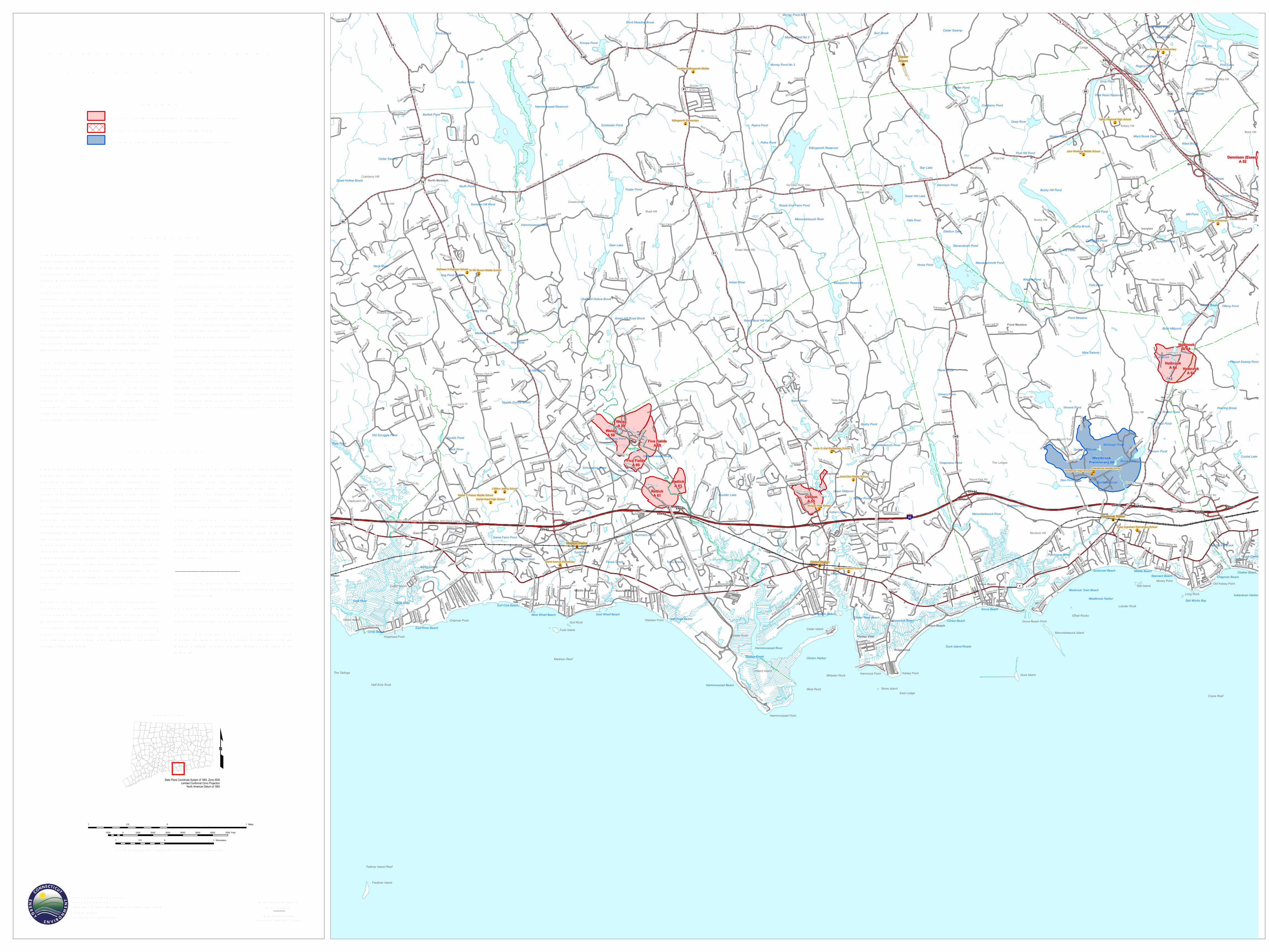
AQU IFER PROTECTION AREASCLINTON, CONNECTICU T
EXPLANATIONThe Aquifer Protection Program , adm in istered b y theCon n ecticut Departm en t of En ergy & En viron m en talProtection (DEEP), provides prim ary protection forCon n ecticut’s high-yield pub lic water supply wellfields. Responsib ilities within the program are sharedb y DEEP, m un ic ipalities an d the water com pan ies.The in ten t of this program is to protect the watersupplies b y iden tifyin g the lan d areas con trib utin ggroun d water to the wells through detailed field workan d groun d-water flow m odelin g, an d then b yregulatin g lan d use within those areas. On c e m apped,m un ic ipalities adopt lan d use regulations for the fin alaquifer protection areas, som etim es c alled “wellheadprotection areas”. For exam ple, lan d use in volvin ghazardous m aterials within a design ated aquiferprotection area is strictly m on itored an d regulated.This in form ation is inten ded to b e used to depictregulated Aquifer Protection Areas on a m appreferab ly at 1:24,000 sc ale. The m appin g of theseareas is on e of the requirem en ts of Con n ecticut’sAquifer Protection Area Program . The programrequires water com pan ies to com plete b othprelim in ary an d fin al Aquifer Protection Aream appin g. Prelim in ary m apping provides a gen eralestim ate of the area contrib utin g groun d water to thewell field. Fin al m apping is b ased on exten sive, site-
spec ific, detailed m odelin g of the groun d water flowsystem at the well field. Prelim in ary m apping iscon ducted first an d is repla c ed later with the m oredetailed fin al m apping.The aquifer protection area in form ation c a n b e usedin con jun ction with surfic ial m aterials, b edroc kgeology, elevation, an d soils to m ore thoroughlyun derstan d the physic al c haracteristics of theaquifers. The spatial relationships b etween theseareas an d en viron m en tal quality data suc h as waterquality, non-point sourc e pollution, im paired groun dwater, contam in ated la n ds, an d past, present an dprojected la n d use c an b e an alyzed.This in form ation does not in c lude protection areas forall pub lic water supply wells in Con n ecticut. It on lyin c ludes aquifer protection areas for pub lic watersupply wells loc ated in Con n ecticut that are set instratified drift an d serve a residen tial population of1,000 or m ore. It does not in c lude protection areas forsm aller stratified drift pub lic water supply wells thatserve less than 1,000 people, pub lic water supplywells drilled in to b edrock, nor pub lic water supplywells loc ated in Con n ecticut that serve custom ers outof state.
DATA SOU RCESAQU IFER PROTECTION AREA DATA – AquiferProtection Areas shown on this m ap are from theAquifer Protection Area digital dataset whic hcon tain s polygon data in ten ded to b e used at 1:24,000sc ale. The dataset contain s regulated areas classifiedas Level A Aquifer Protection Area (Fin al) an d LevelB Aquifer Protection Area (Prelim in ary). The datawas collected from 1991 to the presen t an d is activelyupdated as Fin al area m apping repla c es earlierPrelim in ary areas. The Aquifer Protection Areas aredelin eated b y the in dividual water com pan ies own in gthe well fields an d sub m itted to DEEP for approval.Prelim in ary m apping provides a gen eral estim ate ofthe area contrib utin g groun d water to the well field.Fin al m apping is b ased on exten sive, site-spec ific,detailed m odelin g of the groun d water flow system .DEEP m ay adjust Fin al area b oun daries to b econ sisten t with 1:24,000 sc ale topography an d b asem ap data where appropriate durin g the approvalprocess.BASE M AP DATA - Based on data origin ally from1:24,000-sc ale U SGS 7.5 m in ute topographicquadran gle m aps pub lished b etween 1969 an d 1992.It in c ludes politic al b oun daries, railroads, airports,hydrography, geographic n am es an d geographicpla c es. Streets an d street n am es are from Tele Atlas®copyrighted data. Base m ap in form ation is n eithercurrent nor com plete.
M ASSACHU SETTS WELLHEAD PROTECTIONDATA - The M assac husetts Wellhead ProtectionAreas whic h m ay b e shown on this m ap weredown loaded from the M assGIS web site. Thein form ation was pub lished on July 9, 2014. M orein form ation ab out wellhead protection inM assac husetts is availa b le from www.m ass.gov/deep.RHODE ISLAND WELLHEAD PROTECTIONDATA - The Rhode Islan d Wellhead ProtectionAreas whic h m ay b e shown on this m ap wereob tain ed from RIGIS. The in form ation was pub lishedin Dec em b er 2014. M ore in form ation ab out wellheadprotection in Rhode Islan d is availa b le fromwww.dem .ri.gov.RELATED INFORM ATIONThis m ap is inten ded to b e printed at its origin aldim en sions in order to m ain tain the 1:24,000 sc ale (1in c h = 2000 feet).AQU IFER PROTECTION PROGRAM - Go to theDEEP web site for m ore in form ation on the AquiferProtection Program an d the aquifer protection areas.M APS AND DIGITAL DATA - Go to the CT ECOweb site for this m ap an d a variety of others. Go to theDEEP web site for the digital spatial data shown onthis m ap.
STATE OF CONNECTICU TDEPARTM ENT OF ENERGY & ENV IRONM ENTAL PROTECTION79 Elm StreetHartford, CT 06106-5127
M AP LOCATION
State Plane Coordinate System of 1983, Zone 3526Lambert Conformal Conic Projection
North American Datum of 1983
SCALE 1:24,000 (1 in c h = 2000 feet) when m ap is prin ted at origin al size
1 0 10.5 Miles
1000 0 1000 2000 3000 4000 5000 6000 7000 Feet
1 0 10.5 Kilometers
M ap created b y DEEPM arc h 2018M ap is not colorfast
Protect from light an d m oisture
LEGENDLevel A Aquifer Protection Area (Fin al Adopted)Level A Aquifer Protection Area (Fin al)Level B Aquifer Protection Area (Prelim in ary)