Application of fuzzy AHP method to integrate geophysical data in … · 2016-04-14 · Application...
20
Bollettino di Geofisica Teorica ed Applicata Vol. 54, n. 2, pp. 145-164; June 2013 DOI 10.4430/bgta0085 145 Application of fuzzy AHP method to integrate geophysical data in a prospect scale, a case study: Seridune copper deposit M. ABEDI 1 , S.A. TORABI 2 and G.H. NOROUZI 1 1 Department of Mining Engineering, College of Engineering, University of Tehran, Iran 2 Dpt. Industrial Eng., College of Engineering, University of Tehran, Iran (Received, January 7, 2012; accepted: October 12, 2012) ABSTRACT This paper describes the usage of fuzzy knowledge based method to integrate various geophysical data in order to prepare Mineral Prospectivity Map (MPM). Different geophysical layers which are derived from magnetic and electrical surveys are used to evaluate Seridune copper deposit located in the Kerman province of Iran. Since, electrical layers involving resistivity, induced polarization and metal factor, in comparison with layers derived from magnetic survey, are more important in porphyry copper exploration, fuzzy Analytical Hierarchy Process (AHP) is used to determine the weights belonged to each of them. Four layers which are derived from magnetic data involving upward continuation, analytic signal, reduced to pole and pseudo gravity are considered in this study. Three geoscientists who are expert in geophysical prospecting are used to implement fuzzy AHP. After determination of the normalized weights of the seven evidential layers as main criteria, fuzzy operators are applied to integrate different layers. To evaluate the result of the approach, drilled boreholes are used to validate final MPM. By considering a borehole which is belonged to the suggested area for drilling, a satisfactory result was obtained. The proposed method can be a useful approach for integrating various geodata sets for MPM. Key words: fuzzy AHP, fuzzy operators, electrical and magnetic surveys, MPM, porphyry copper deposit. © 2013 – OGS 1. Introduction Mineral exploration is a sophisticated process in which the main purpose is to discover a new mineral deposit in the region of interest. To achieve this goal, one of the main steps in mineral exploration is to demarcate prospective areas in the region. In this manner to do so, various thematic (e.g., geological, geophysical, geochemical) geodata sets should be collected, analysed and integrated for Mineral Prospectivity Map (MPM) in the region of interest. The MPM process is, in fact, a Multi-Criteria Decision-Making (MCDM) task in different scales. However, the MPM is a predictive model of outlining prospective areas. Several approaches may be used for MPM, which can be divided into either, data-driven or knowledge-driven methods (Bonham-Carter, 1994; Pan and Harris, 2000; Carranza, 2008). In data-driven techniques, the known mineral deposits in a region of interest are used as ‘training points’ for establishing spatial relationships with particular geological, geochemical and geophysical features. The spatial relationships between the input data and the training points
Transcript of Application of fuzzy AHP method to integrate geophysical data in … · 2016-04-14 · Application...

Bollettino di Geofisica Teorica ed Applicata Vol. 54, n. 2, pp. 145-164; June 2013
DOI 10.4430/bgta0085
145
Application of fuzzy AHP method to integrate geophysical data in a prospect scale, a case study: Seridune copper deposit
M. Abedi1, S.A. TorAbi2 and G.H. Norouzi1
1 Department of Mining Engineering, College of Engineering, University of Tehran, Iran 2 Dpt. Industrial Eng., College of Engineering, University of Tehran, Iran
(Received, January 7, 2012; accepted: October 12, 2012)
ABSTRACT Thispaperdescribestheusageoffuzzyknowledgebasedmethodtointegratevariousgeophysical data in order to prepare Mineral Prospectivity Map (MPM). DifferentgeophysicallayerswhicharederivedfrommagneticandelectricalsurveysareusedtoevaluateSeridunecopperdeposit located in theKermanprovinceof Iran.Since,electrical layers involving resistivity, induced polarization and metal factor, incomparisonwithlayersderivedfrommagneticsurvey,aremoreimportantinporphyrycopperexploration,fuzzyAnalyticalHierarchyProcess(AHP)isusedtodeterminetheweightsbelongedtoeachofthem.Fourlayerswhicharederivedfrommagneticdatainvolvingupwardcontinuation,analyticsignal,reducedtopoleandpseudogravityareconsideredinthisstudy.ThreegeoscientistswhoareexpertingeophysicalprospectingareusedtoimplementfuzzyAHP.Afterdeterminationofthenormalizedweightsofthesevenevidential layersasmaincriteria, fuzzyoperatorsareapplied to integratedifferentlayers.Toevaluatetheresultoftheapproach,drilledboreholesareusedtovalidate final MPM. By considering a borehole which is belonged to the suggested area fordrilling,asatisfactoryresultwasobtained.TheproposedmethodcanbeausefulapproachforintegratingvariousgeodatasetsforMPM.
Key words: fuzzyAHP,fuzzyoperators,electricalandmagneticsurveys,MPM,porphyrycopperdeposit.
© 2013 – OGS
1. Introduction
Mineralexplorationisasophisticatedprocessinwhichthemainpurposeistodiscoveranewmineraldepositintheregionofinterest.Toachievethisgoal,oneofthemainstepsinmineralexploration is to demarcate prospective areas in the region. In this manner to do so, variousthematic(e.g.,geological,geophysical,geochemical)geodatasetsshouldbecollected,analysedand integrated for Mineral Prospectivity Map (MPM) in the region of interest.The MPMprocessis,infact,aMulti-CriteriaDecision-Making(MCDM)taskindifferentscales.However,theMPMisapredictivemodelofoutliningprospectiveareas.
SeveralapproachesmaybeusedforMPM,whichcanbedividedintoeither,data-drivenorknowledge-driven methods (Bonham-Carter, 1994; Pan and Harris, 2000; Carranza, 2008). In data-driventechniques,theknownmineraldepositsinaregionofinterestareusedas‘trainingpoints’ for establishing spatial relationships with particular geological, geochemical andgeophysical features.The spatial relationships between the input data and the training points

146
Boll. Geof. Teor. Appl., 54, 145-164 Abedi et al.
arequantifiedandusedtoestablishtheimportanceofeachevidencemapandfinallyintegratedinto a single MPM (Nykänen and Salmirinne, 2007; Carranza, 2009). Examples of the empirical methods used are weights of evidence (Bonham-Carter et al., 1989), logistic regression (Agterberg and Bonham-Carter, 1999), neural networks (Singer and Kouda, 1996; Porwal et al.,2003, 2004), and evidential belief functions (Carranza and Hale, 2002; Carranza, 2008).
Theothertechniques,inwhichgeoscientist’sexpertopinionisapplied,arecalledknowledge-driven methods involving the use of Boolean logic (Bonham-Carter, 1994), index overlay (Bonham-Carter, 1994), the Dempster-Shafer belief theory (Moon, 1990), and fuzzy logic overlay (Chung and Moon, 1990; An et al., 1991).
Iftherearedatabasesofpreviousexplorationprojects,MPMcanbeaclassificationprocessforoutliningnewprospectiveareasinaregionofinterest.Therearetwotypesofclassification:supervised and unsupervised. Supervised classification is used to categorise every locationas either prospective or non-prospective based on various evidential layers and a trainingdatavectorofknowndeposit locationsandnon-deposit locations.Theother type isknownasunsupervisedclassificationisbasedonlyonfeaturesstatisticsofevidentiallayers.
Selecting thebestarea forexploratorydrilling isaMCDMproblem. In this study,differentevidencelayersofgeophysicaldatasuchaselectricalandmagneticsurveysareusedtoprepareMPM.FuzzyAnalyticalHierarchyProcess(AHP)isappliedtodeterminetheweightsbelongedtoeachlayerinordertointegratetheseevidentiallayers.ThreeDecisionMakers(DMs)whohavetheknowledge related togeophysicalprospect areused to calculateweightsusing fuzzyAHP.Finally,fuzzyoperatorsareusedtointegrateweightedlayerstogeneratefinalMPM.Realdata,Seridunecopperdeposit locatedinKerman,centralpartofIran, ischosentosuggestadditionaldrilling.ObtainedresultsarecomparedtotheboreholesinthestudyareatovalidatetheMPM.
2. Fuzzy Knowledge based Method
Summaryofthemethodsaredescribedasfollow.
2.1. AHP methodThe AHP which was suggested and developed by Saaty (1980, 1986, 1988, 1995) is one
of the well-known techniques used as MCDM approach. TheAHP is a theory of relativemeasurement on absolute scales of both tangible and intangible criteria, based both on thejudgment of knowledgeable and expert people and on existing measurements and statisticsneededtomakeadecision.HowtomeasureintangiblesisthemainconcernofthemathematicsoftheAHP.TheAHPhasbeenmostlyappliedtomulti-objective,multi-criteriaandmultipartydecisionsbecausedecision-makinghasthisdiversity(Figueiraet al., 2005).
The procedure of applying the AHP is based on three principles, namely: (1) construction of a hierarchy, (2) priority setting and (3) logical consistency (Macharis et al., 2004). These proceduresaredescribedasfollow.
2.1.1. Construction of a hierarchyThe first step to implement theAHP for a complex decision problem is structured as a
hierarchy.AHPinitiallybreaksdownacomplexMCDMproblemintoahierarchyofinterrelated

Application of fuzzy AHP method to integrate geophysical data Boll. Geof. Teor. Appl., 54, 145-164
147
decision elements (criteria, decision alternatives).With theAHP, the objectives, criteria andalternativesarearrangedinahierarchicalstructuresimilar toafamilytree.Ahierarchyhasatleastthreelevels:overallgoaloftheproblematthetop,multiplecriteriathatdefinealternativesin the middle, and decision alternatives at the bottom (Daǧdeviren, 2008). The hierarchical structure that is used to prepare MPM in this study is shown in Fig. 1.
2.1.2. Priority settingThe relative ‘‘priorityorweight’’ given to each element in thehierarchy is determinedby
comparingpairwisethecontributionofeachelementatalowerlevelintermsofthecriteria(orelements)withwhichacausalrelationshipexists(Machariset al., 2004). The pairwise judgment starts from the second level and finishes in the lowest level, alternatives. In each level thecriteriaarecomparedpairwiseaccordingtotheirlevelofinfluenceandbasedonthespecifiedcriteriainthehigherlevel.TheDMusesastandardisedcomparisonscaleofninelevelsthatisshown in Table 1 (Daǧdeviren, 2008).
Fig. 1 - Hierarchical structure of mineral prospectivity map.
Table 1 - Nine-point intensity of importance scale and its description.
Definition Intensity of importance
Equally important 1
Moderately more important 3
Strongly more important 5
Very strongly more important 7
Extremely more important 9
Intermediate values 2, 4, 6, 8

148
Boll. Geof. Teor. Appl., 54, 145-164 Abedi et al.
LetC = {Cj | j = 1, 2, ..., n}be the set of criteria.The results of thepairwise comparisonon n criteria can be summarized in an (n × n) evaluation matrix A in which every elementaij(i,j = 1, 2, ..., n) is the amount of weights of the criteria that is shown in Eq. 1 (Daǧdeviren, 2008):
(1)
Themathematicalprocessstartstonormaliseandfindtherelativeweightsforeachmatrix.The relative weights are given by the right eigenvector (G) corresponding to the largesteigenvalue(λmax)as:
AG=λmax G (2)
Ifthepairwisecomparisonarecompletelyconsistent,thematrixA has rank 1 and λmax=n.In thatcase,weightscanbeacquiredbynormalisinganyof the rowsorcolumnsofAmatrix(Daǧdeviren, 2008).
2.1.3. Logical consistencyIt should be noted that the quality of the output of theAHP is strictly related to the
consistency of the pairwise comparison judgments.The complete consistency is defined forrelationasfollow:
aij × ajk= aik (3)
whenthepairwisecomparisonmatricesarecompletelyconsistent,thepriority(orweight)vectorcorrespondstotherighteigenvector(G).Therefore,thehighesteigenvalue(λmax)isequalton.Incasetheinconsistencyofthepairwisecomparisonmatricesislimited,slightlyλmaxdeviatesfromn.Thisdeviation(λmax–n)isusedasameasureforinconsistency.Thismeasurethatisdividedby(n-1) yields the average of the other eigenvectors (Macharis et al., 2004). The consistency index(CI)is:
CI=(λmax–n)/(n – 1) (4)
The final Consistency Ratio (CR), on the basis of which one can conclude whether theevaluationsaresufficientlyconsistent,iscalculatedastheratiooftheCIandtheRandomIndex(RI is given in Table 2) and it corresponds to the degree of consistency that automatically arises when completing at random reciprocal matrices with the values on the 1 - 9 scale (Macharis et al., 2004):
CR=CI/RI. (5)
.

Application of fuzzy AHP method to integrate geophysical data Boll. Geof. Teor. Appl., 54, 145-164
149
The number 0.1 is the accepted upper limit for CR. If the final CR exceeds this value,the evaluation procedure has to be repeated to improve consistency. The measurement ofconsistencycanbeusedtoevaluatetheconsistencyofDMsaswellastheconsistencyofallthehierarchy (Daǧdeviren, 2008).
Table 2 - Random Index (from Macharis et al., 2004).
n
RI
1
0.00
2
0.00
3
0.58
4
0.90
5
1.12
6
1.24
7
1.32
8
1.41
9
1.45
10
1.49
11
1.51
12
1.48
13
1.56
14
1.57
15
1.59
2.2. Fuzzy AHP methodInthefuzzyextensionofAHP,theweightsofthenine-levelfundamentalscalesofjudgments
are expressed via the Triangular Fuzzy Numbers (TFN) in order to represent the relativeimportanceamongthehierarchycriteria(Karimiet al., 2011).
AfuzzynumberMonR(M∈M(R))isaTFNifitsmembershipfunctionsμM(x):R➝ [0,1] isequalto
(6)
where l ≤ m ≤ u, l andustandfortheloweranduppervalueofthesupportofM respectively,andm gives themaximalgradeof themembership functionμM(x).Here,M(R) representsallfuzzysets,andRisthesetofrealnumbers.Thetriangularfuzzynumbercanbedenotedby(l, m, u).ThesupportofMisthesetofelements{x∈R|l<x<u} (Chang, 1996).
The fuzzyAHP is apopular techniquewhichhasbeen applied forMCDMproblems.Thismethod was expressed by Laarhoven and Pedrycs (1983) where the fuzzy comparing judgment is represented by TFN. The steps of applying fuzzy AHP that is suggested by Chang (1996) are used inthisstudy.ThepaperpublishedbyKarimiet al. (2011) is used to describe these steps as follow:
Step 1: a group of tDecisionMakers (DMp) is used to prepare pairwise comparison. Each DM individually will construct a Pairwise Comparison Matrix (PCM) as shown in Eq. (7) for eachcriterion:
(7)

150
Boll. Geof. Teor. Appl., 54, 145-164 Abedi et al.
where, m is the number of alternatives for each criterion and t is the number of DMs.For instance in Fig. 1, the number of alternatives m for magnetic criterion is 4. Then, a comprehensive PCM is constructed by integrating the grades of all DMs via Eq. (8). By this way,thePCMvaluesofDMsaretransformedintoTFNtomakethefuzzyevaluationmatrix:
(8)
where,min(aijp) andmax(aijp
) indicateminimumandmaximumvaluesofPCMspreparedbyDMs for each i, j respectively.This step is used to construct fuzzy evaluation matrices withrespecttocriteriaandalternativesofdesignedhierarchy.
Step 2: the value of the fuzzy synthetic extent with respect to the i-thobjectofmalternativesforeachcriterionisdefinedby:
(9)
where, all the Mij areTFNs after construction of the fuzzy evaluation matrix.The symbol indicates the fuzzy multiplication operator. Considering two TFNs M1=(l1,m1,u1) andM2=(l2,m2,u2),theiroperationallawsareasfollows:
(10)
(11)
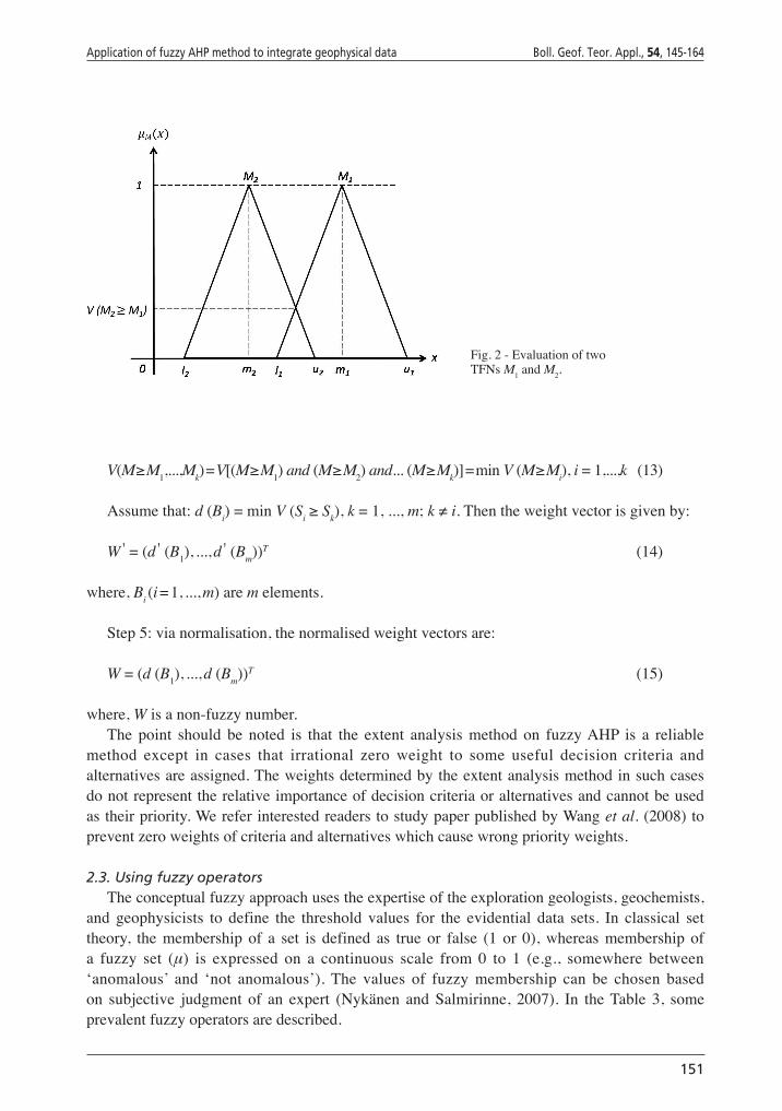
Step 3: as M1=(l1,m1,u1)andM2=(l2,m2,u2)aretwoTFNs,thedegreeofpossibility(V)ofM2 ≥ M1isdefinedby:
(12)
Fig. 2 represents evaluation of two TFNs M1andM2.
Step 4: to compare M1 and M2, it needs to consider both values of V(M2 ≥ M1) andV(M1 ≥ M2).The degree possibility for a convex fuzzy number to be greater than k convexfuzzynumbersMi(i = 1, ..., k)canbedefinedby:
.
.
Application of fuzzy AHP method to integrate geophysical data Boll. Geof. Teor. Appl., 54, 145-164
151
Fig. 2 - Evaluation of two TFNsM1andM2.
V(M ≥ M1,...,Mk)=V[(M ≥ M1)and(M ≥ M2)and... (M ≥ Mk)] = min V(M ≥ Mi),i = 1,...,k (13)
Assumethat:d(Bi)=minV(Si ≥ Sk),k = 1, ..., m; k � i.Thentheweightvectorisgivenby:
W '=(d '(B1), ..., d '(Bm))T (14)
where,Bi (i = 1, ..., m)aremelements.
Step 5: via normalisation, the normalised weight vectors are:
W=(d(B1), ..., d(Bm))T (15)
where,Wisanon-fuzzynumber.The point should be noted is that the extent analysis method on fuzzyAHP is a reliable
method except in cases that irrational zero weight to some useful decision criteria andalternativesareassigned.Theweightsdeterminedbytheextentanalysismethodinsuchcasesdonotrepresenttherelativeimportanceofdecisioncriteriaoralternativesandcannotbeusedastheirpriority.WereferinterestedreaderstostudypaperpublishedbyWanget al. (2008) to preventzeroweightsofcriteriaandalternativeswhichcausewrongpriorityweights.
2.3. Using fuzzy operatorsTheconceptualfuzzyapproachusestheexpertiseoftheexplorationgeologists,geochemists,
and geophysicists to define the threshold values for the evidential data sets. In classical settheory, the membership of a set is defined as true or false (1 or 0), whereas membership of a fuzzy set (μ) is expressed on a continuous scale from 0 to 1 (e.g., somewhere between ‘anomalous’ and ‘not anomalous’).The values of fuzzy membership can be chosen basedon subjective judgment of an expert (Nykänen and Salmirinne, 2007). In the Table 3, some prevalentfuzzyoperatorsaredescribed.

152
Boll. Geof. Teor. Appl., 54, 145-164 Abedi et al.
It is common to determine the weight of alternatives by knowledge-driven methods suchas fuzzyAHP. In this study, fuzzyAHP method is applied to calculate the weights of eachevidential layer and then fuzzy operators are used to integrate them; finally MPM is produced.
The summary procedure of applying fuzzy method to prepare MPM is shown in Fig. 3.
Fig. 3 - The procedure of applying fuzzy method.
*μ1,μ2,...,μN are, respectively, the input fuzzy evidential scores at a location in evidence map 1, evidence map 2, … evidencemapn.
Table 3 - Fuzzy operators (Bonham-Carter, 1994; Nykänen and Salmirinne, 2007).
Description Boolean Equivalent Function Operator
It works as minimum operator and creates AND Fuzzy AND smallest fuzzy membership values. Fuzzy AND uses when all the evidence must exist for a mineral occurrence.
It works as maximum operator and creates OR Fuzzy OR largest fuzzy membership values. Fuzzy OR uses when every of evidence could be sufficient for a mineral occurrence.
It tends to reduce effect of multiplying Fuzzy Algebraic several numbers smaller than, or equal to, Product the smallest contributing membership value.
It tends to increase effect of multiplying Fuzzy Algebraic several numbers larger, or equal to, the Sum largest contributing membership value.
It combines the effect of fuzzy algebraic Fuzzy Gamma product and the fuzzy algebraic sum.
Application of fuzzy AHP method to integrate geophysical data Boll. Geof. Teor. Appl., 54, 145-164
153
3. Geology of the study area
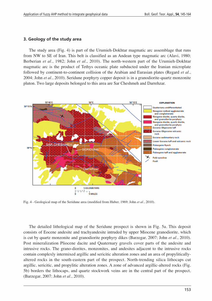
The study area (Fig. 4) is part of the Urumieh-Dokhtar magmatic arc assemblage that runs from NW to SE of Iran. This belt is classified as an Andean type magmatic arc (Alavi, 1980; Berberian et al., 1982; John et al., 2010). The north-western part of the Urumieh-Dokhtar magmatic arc is the product ofTethys oceanic plate subducted under the Iranian microplatefollowed by continent-to-continent collision of the Arabian and Eurasian plates (Regard et al.,2004; John et al., 2010). Seridune porphyry copper deposit is in a granodiorite-quartz monzonite pluton.TwolargedepositsbelongedtothisareaareSarCheshmehandDarrehzar.
Fig. 4 - Geological map of the Seridune area (modified from Huber, 1969; John et al., 2010).
The detailed lithological map of the Seridune prospect is shown in Fig. 5a. This deposit consists of Eocene andesite and trachyandesite intruded by upper Miocene granodiorite, which is cut by quartz monzonite and granodiorite porphyry dikes (Barzegar, 2007; John et al., 2010). Post mineralization Pliocene dacite and Quaternary gravels cover parts of the andesite andintrusive rocks.The grano-diorites, monzonites, and andesites adjacent to the intrusive rockscontaincomplexlyintermixedargillicandsericiticalterationzonesandanareaofpropylitically-altered rocks in the south-eastern part of the prospect. North-trending silica lithocaps cutargillic,sericitic,andpropyliticalterationzones.Azoneofadvancedargillic-alteredrocks(Fig.5b) borders the lithocaps, and quartz stockwork veins are in the central part of the prospect, (Barzegar, 2007; John et al., 2010).

154
Boll. Geof. Teor. Appl., 54, 145-164 Abedi et al.
4. Application of fuzzy AHP to Seridune copper deposit
4.1. Criteria for MPMTwo common geophysical methods to prospect porphyry copper deposit are magnetic
and electrical surveys. Magnetic methods are used in the exploration and characterizationof porphyry copper deposits worldwide.The primary control on bulk magnetic propertiesof host rock and magnetic intrusions is the partitioning of iron between oxides and silicates(Clark, 1999), although sulphide minerals associated with hydrothermal alteration also provide fundamental, localized geophysical targets (John et al., 2010). Simple models for porphyry copper deposits involve contrasting zones of alteration centered about the deposit. Magneticanomalies,at least inprinciple, reflect the locationof thesezones:weak localmagnetichighsover the potassic zone, low magnetic intensity over sericitic zones, and gradually increasingintensities over the propylitic zone (Thoman et al., 2000). As an example, Fig. 6 shows the magnetic anomaly over a hypothetical but geologically plausible porphyry copper deposit (John et al., 2010).
Theresistivitymethodisoneoftheoldesttechniquesingeophysicalexploration.Resistivityisameasureoftheabilityofelectricalchargetoformcurrentsthatmovethroughthegeologicalsection. Minerals and rocks associated with hydrothermal alteration often have anomalouselectrical properties, and thus geophysical methods that detect and model such propertiesare mainstays in the exploration for and characterization of porphyry copper deposits. Likethe distribution of magnetic minerals, electrical properties reflect the type and degree ofhydrothermalalteration.Hydrothermalmineralsrelevant togeophysicalexplorationarepyrite,
Fig. 5 - a) Detailed lithological map of the Seridune prospect (Barzegar, 2007). Mal=malachite, Azu=azurite, Chry=chrysocolla, Hem=hematite, Lm=limonite, m.a.s.l=meter above sea level; b) Hydrothermal alteration map of the Seridune prospect (John et al., 2010).

Application of fuzzy AHP method to integrate geophysical data Boll. Geof. Teor. Appl., 54, 145-164
155
Fig. 6 - Magnetic anomaly caused by a hypothetical porphyry copper deposit. Magnetic field parameters are assumed as inclination 58.3° and declination 11.6°. M indicates magnetizations in amperes per meter (A/m) (from John et al., 2010).
chalcopyrite,chalcocite,biotite,andsericite.Aswithmagneticanomalies,wewouldexpecttoseetheintensityandtypeofalterationreflectedinresistivityanomalies,withlowestresistivitycentered on sericitic alteration that is developed in zones of most fracturing and fluid flow(Thomanet al., 2000; John et al., 2010). The dispersed nature of sulphide minerals in porphyry systems is particularly suitable for Induced Polarization (IP) methods (Sinclair, 2007). Indeed, the IP method was originally developed for the exploration of porphyry copper deposits (Brant, 1966) and still is commonly used. IP is a complex phenomenon. In simplest terms, IP anomalies reflect theabilityofamineral, rock,or lithologytoactasanelectricalcapacitor. Inporphyrycopper deposits, the strongest IP responses correlate with quartz-sericite-pyrite alteration(Thomanet al., 2000; John et al., 2010).
Typically, thezoneofpotassicalteration in thecoreof thedeposit is low in total sulphideminerals,thesurroundingzoneofsericiticalterationhashighsulphidecontent,includingpyrite,andthedistalzoneofpropyliticalterationhaslowpyrite.Thus,thesericiticzoneofalterationisan important IP target (John et al., 2010). Therefore, various layers of information are derived frommagneticandelectricalsurveytoproduceMPM.
4.2. Using fuzzy knowledge based methodIn this study, seven layers of geophysical data are used toprepareprospectivitymap.The
mostcommongeophysicalmethodsforexplorationofsulfidedepositsexplorationareelectricaltechniques. In thisstudy,Resistivity(RS), IP“chargeabilitymap”,andmetal factormap(asaratio of chargeability to resistivity) are used. Rectangular array with 1200 m space as current electrode was used in the study area such that distances between profiles and stations were 100

156
Boll. Geof. Teor. Appl., 54, 145-164 Abedi et al.
and 20 m. These maps are shown in Fig. 7.Ground-based magnetic survey was done in the area, whereby distances between profiles
and stations were 100 and 20 m respectively. The geomagnetic field is 45770 nT (inclination = 46.4°, declination = 2.3°). Analytical upward continuation was used because it is suspected that copperdepositexistsatdepth.Thismethodcalculates themagneticfieldfurther to thesourceand consequently results in a better map of deep deposit and reduces the effect of shallowstructures with high frequency. Map of residual magnetic data that were upward continued to 20 m (UP20) is shown in Fig. 8a.
A general filter operation applied to magnetic data is ReducedTo the Pole (RTP), whichis a technique that converts magnetic anomaly to symmetrical pattern that would have been observedwithverticalmagnetization.RTPtechniqueeliminatesthedipolarnatureofmagneticanomalies and converts its asymmetric shape to symmetric shape (Ansari and Alamdar, 2009). The RTP map of Seridune prospect is shown in Fig. 8b.
Many filters are available to enhancemagnetic fielddata, such asdownward continuation,horizontalandverticalderivatives,andotherformsofhigh-passfilters.Oneofthesetechniquesistheanalyticsignalmethod.Thebasicconceptoftheanalyticsignalmethodformagneticdatawasextensively discussed by Nabighian (1972, 1974, 1984). Fig. 8c shows the analytic signal map.
PseudogravitytransformationofmagneticdataisbasedonPoissonrelationthattransformsmagnetictogravity.Theassumptionisthatboththemagneticandgravitysignalsarecausedbythesameanomalousbody(with thesamegeometry)and thatmagneticanomaliesareentirelyinduced by the present geomagnetic field (no remanent magnetization).This filter can showthe boundary of anomalies better than magnetic data, and can be a simple tool to interpretby geologist. Interested readers are referred to Blakely (1995) for additional details of this transformation. The pseudo gravity map is shown in Fig. 8d.
Three DMs who are expert in geophysical prospect must be used at least to apply fuzzyAHPprocedure.Inthisstudy,threeDMswereusedtoconstructpairwisecomparisonmatrices.AfterformingthedecisionhierarchyforMPM,thecriteriatobeusedinevaluationprocessareassignedweightsbyusingAHPmethod.ThreeDMsaregiven the taskof forming individualPCM by use of scale in Table 1.
AllconsistencyratiosobtainedfromthePCMforimplementingAHParepresentedinTable4. All of them are less than 0.1. So, the results are used to make fuzzy evaluation matrices. Fuzzyevaluationorpairwisematriceswithrespecttocriteriaofgeophysicalprospecting,geo-electricalalternatives,andmagneticalternativesconstructedbyDMswhicharetransformedintoTFN are brought in Tables (5 to 7).
Table 4 - CR of the pairwise comparison matrix.
CI
Criteria Geo-Electrical Alternatives Magnetic Alternatives
Electric Magnetic Resistivity Induced Metal UP- Reduced Analytic Pseudo
Polarization Factor warded to Pole Signal Gravity
DM1 0 0.0158 0.0899
DM2 0 0.0032 0.0263
DM3 0 0.0739 0.0038

Application of fuzzy AHP method to integrate geophysical data Boll. Geof. Teor. Appl., 54, 145-164
157
(a)
Fig. 7 - Geo-electrical layers, a) RS map, b) IP “chargeability map”, c) metal factor.
(b)
(c)

158
Boll. Geof. Teor. Appl., 54, 145-164 Abedi et al.
(a)
Fig. 8 - Magnetic layers, a) UP20, b) RTP of magnetic data, c) analytic signal of magnetic data, d) pseudo gravity.
(b)
(c) (d)
Application of fuzzy AHP method to integrate geophysical data Boll. Geof. Teor. Appl., 54, 145-164
159
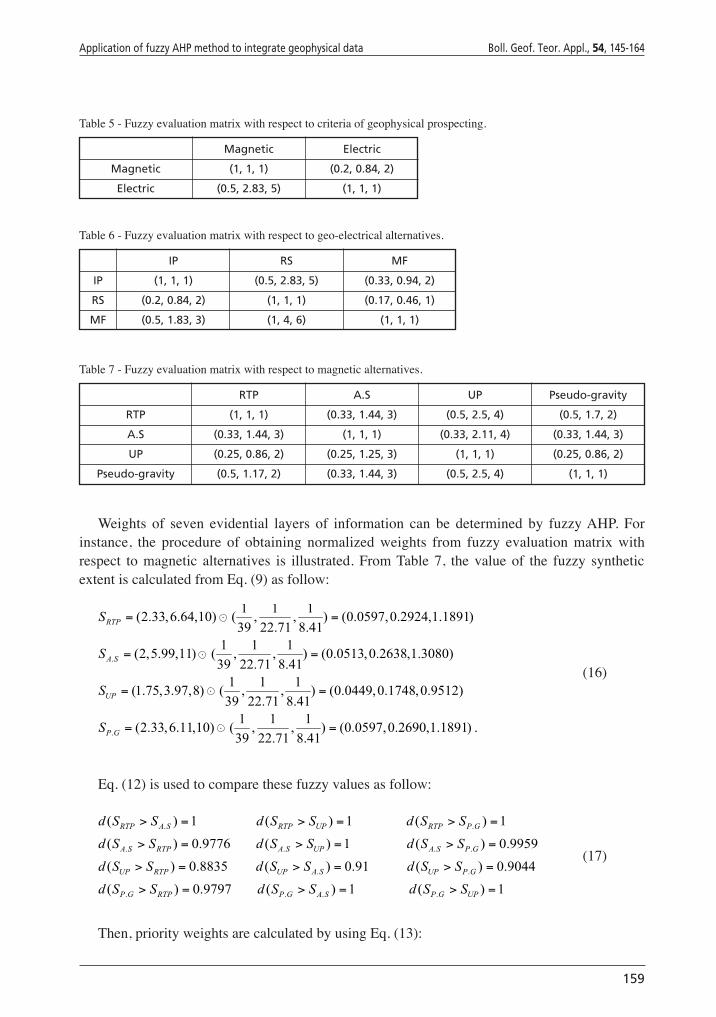
Weights of seven evidential layers of information can be determined by fuzzyAHP. Forinstance, the procedure of obtaining normalized weights from fuzzy evaluation matrix withrespect to magnetic alternatives is illustrated. From Table 7, the value of the fuzzy synthetic extent is calculated from Eq. (9) as follow:
Eq. (12) is used to compare these fuzzy values as follow:
Then, priority weights are calculated by using Eq. (13):
Table 5 - Fuzzy evaluation matrix with respect to criteria of geophysical prospecting.
Magnetic Electric
Magnetic (1, 1, 1) (0.2, 0.84, 2)
Electric (0.5, 2.83, 5) (1, 1, 1)
Table 6 - Fuzzy evaluation matrix with respect to geo-electrical alternatives.
IP RS MF
IP (1, 1, 1) (0.5, 2.83, 5) (0.33, 0.94, 2)
RS (0.2, 0.84, 2) (1, 1, 1) (0.17, 0.46, 1)
MF (0.5, 1.83, 3) (1, 4, 6) (1, 1, 1)
Table 7 - Fuzzy evaluation matrix with respect to magnetic alternatives.
RTP A.S UP Pseudo-gravity
RTP (1, 1, 1) (0.33, 1.44, 3) (0.5, 2.5, 4) (0.5, 1.7, 2)
A.S (0.33, 1.44, 3) (1, 1, 1) (0.33, 2.11, 4) (0.33, 1.44, 3)
UP (0.25, 0.86, 2) (0.25, 1.25, 3) (1, 1, 1) (0.25, 0.86, 2)
Pseudo-gravity (0.5, 1.17, 2) (0.33, 1.44, 3) (0.5, 2.5, 4) (1, 1, 1)
(16)
.
(17)
160
Boll. Geof. Teor. Appl., 54, 145-164 Abedi et al.
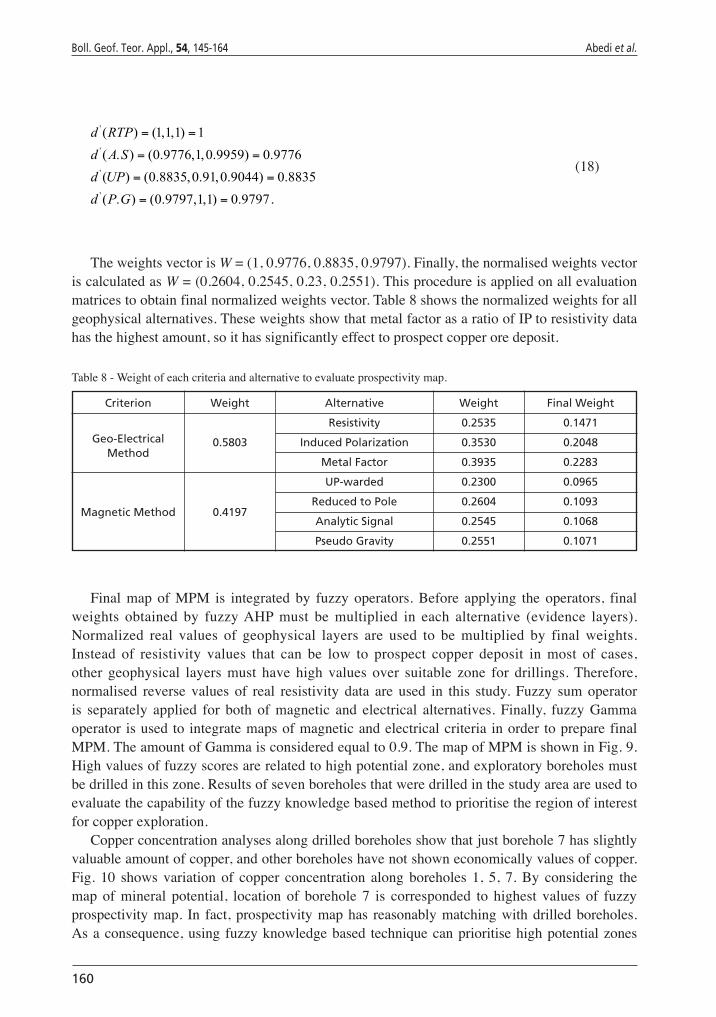
TheweightsvectorisW = (1, 0.9776, 0.8835, 0.9797). Finally, the normalised weights vector iscalculatedasW = (0.2604, 0.2545, 0.23, 0.2551). This procedure is applied on all evaluation matrices to obtain final normalized weights vector. Table 8 shows the normalized weights for all geophysicalalternatives.TheseweightsshowthatmetalfactorasaratioofIPtoresistivitydatahasthehighestamount,soithassignificantlyeffecttoprospectcopperoredeposit.
Table 8 - Weight of each criteria and alternative to evaluate prospectivity map.
Criterion Weight Alternative Weight Final Weight
Geo-Electrical
Resistivity 0.2535 0.1471
Method
0.5803 Induced Polarization 0.3530 0.2048
Metal Factor 0.3935 0.2283
UP-warded 0.2300 0.0965
Magnetic Method 0.4197
Reduced to Pole 0.2604 0.1093
Analytic Signal 0.2545 0.1068
Pseudo Gravity 0.2551 0.1071
Final map of MPM is integrated by fuzzy operators. Before applying the operators, final weights obtained by fuzzyAHP must be multiplied in each alternative (evidence layers).Normalized real values of geophysical layers are used to be multiplied by final weights.Instead of resistivity values that can be low to prospect copper deposit in most of cases,other geophysical layers must have high values over suitable zone for drillings.Therefore,normalised reverse values of real resistivity data are used in this study. Fuzzy sum operatoris separately applied for both of magnetic and electrical alternatives. Finally, fuzzy Gamma operator isusedtointegratemapsofmagneticandelectricalcriteria inorder topreparefinalMPM. The amount of Gamma is considered equal to 0.9. The map of MPM is shown in Fig. 9. Highvaluesoffuzzyscoresarerelatedtohighpotentialzone,andexploratoryboreholesmustbedrilledinthiszone.Resultsofsevenboreholesthatweredrilledinthestudyareaareusedtoevaluatethecapabilityofthefuzzyknowledgebasedmethodtoprioritisetheregionofinterestforcopperexploration.
Copper concentration analyses along drilled boreholes show that just borehole 7 has slightly valuableamountofcopper,andotherboreholeshavenotshowneconomicallyvaluesofcopper.Fig. 10 shows variation of copper concentration along boreholes 1, 5, 7. By considering the map of mineral potential, location of borehole 7 is corresponded to highest values of fuzzy prospectivitymap. In fact,prospectivitymaphas reasonablymatchingwithdrilledboreholes.Asaconsequence,using fuzzyknowledgebased techniquecanprioritisehighpotentialzones
(18)
.

Application of fuzzy AHP method to integrate geophysical data Boll. Geof. Teor. Appl., 54, 145-164
161
Fig. 9 - Final map generated by fuzzy knowledgebasedmethod.
(a) (b) (c)
Fig. 10 - Variation of Cu concentration along boreholes, a) 1, b) 5, c) 7.

162
Boll. Geof. Teor. Appl., 54, 145-164 Abedi et al.
inmineralprospect,andpreventsdrillinginwronglocationsofprospectarea.Authorssuggestusing geological and geochemical evidential layers simultaneously to integrate them for finalMPM.Theauthorsalsohadnoaccesstoallevidentiallayersforconsideringinthisstudy.
5. Conclusion
Application of fuzzy knowledge based method is considered in this paper. Various geophysicallayersderivedfrommagneticandelectricaldataareusedtopreparemapofmineralpotential.AHPmethod is applied to construct PCMs for geophysical layers as alternatives toproduce finalprospectivitymap.FuzzyAHP technique iscarriedout to reduce thevaguenessanduncertaintyof thePCMs. In fact, fuzzyAHPuses theDMsknowledge todeterminefinalnormalisedweightsofeachgeophysicallayer.Subsequently,theseweightsareusedtointegratenormalised real values of them. Finally, fuzzy operators are applied to produce prospectivitymapforcopperexploration.Resultsofdrilledboreholesintheregionofinterestshowedthattheprospectivitymap is significantlymatchedwithboreholes locations.As a consequence, fuzzyknowledgebasedmethodcanbeausefultoolinmineralpotentialmappingtointegratevariousdatalayers,andreducetheuncertainty.
Acknowledgements. The authors gratefully acknowledge the colleagues of Department of MiningEngineering and Institute of Geophysics, University of Tehran for all their supports.
REFERENCES
Agterberg F.P. and Bonham-Carter G.F.; 1999: Logistic regression and weights of evidence modeling in mineral exploration. In: Proc. 28th Int. Symp. App. Comput. Mineral Ind. (APCOM), Golden, CO, USA, pp. 483-490.
Alavi M.; 1980: Tectonostratigraphic evolution of the Zagrosides of Iran. Geology, 8, 144-149.An P., Moon W.M. and Rencz A.N.; 1991: Application of fuzzy theory for integration of geological, geophysical and
remotely sensed data. Can. J. Explor. Geophys., 27, 1-11.Ansari A.H. and Alamdar K.; 2009: Reduction to the pole of magnetic anomalies using analytic signal. WorldAppl.
Sci. J., 7, 405-409.Barzegar H.; 2007: Geology, petrology and geochemical characteristics of alteration zones within the Seridune
prospect, Kerman, Iran. University of Tehran, unpublished Ph.D. thesis.Berberian F., Muir I.D., Pankhurst R.J. and Berberian M.; 1982: Late Cretaceous and Early Miocene Andean-type
plutonic activity in northern Makran and central Iran. J. Geol. Soc. (London, UK), 139, 605-614.Blakely R.J.; 1995: Potential theory in gravity and magnetic applications. Cambridge Univ. Press, Cambridge, UK,
441 pp.Bonham-Carter G.F.; 1994: Geographic information systems for geoscientists: modelling with GIS.PergamonPress,
Oxford, UK, 398 pp.Bonham-Carter G.F., Agterberg F.P. and Wright D.F.; 1989: Weights-of-evidencemodelling: a new approach to
mapping mineral potential. In: Agterberg F.P. and Bonham-Carter G.F. (eds), Stat. Appl. Earth Sci., Geol. Surv. Canada, Paper 89-9, pp. 171-183.
Brant A.A.; 1966: Geophysics in the exploration for Arizona porphyry deposits.In:TitleyS.R.andHicksC.L.(eds),Geology of the porphyry copper deposits, southwestern North America, University of Arizona Press, Tucson, AR, USA, pp. 87-110.

Application of fuzzy AHP method to integrate geophysical data Boll. Geof. Teor. Appl., 54, 145-164
163
Carranza E.J.M.; 2008: Geochemical anomaly and mineral prospectivity mapping in GIS. Handb. Explor. Environ. Geochem., Elsevier, Amsterdam, Netherland, 368 pp.
Carranza E.J.M.; 2009: Controls on mineral deposit occurrence inferred from analysis of their spatial pattern and spatial association with geological features. Ore Geol. Rev., 35, 383-400.
Carranza E.J.M. and Hale M.; 2002: Evidential belief functions for data-drivengeologically constrained mapping of gold potential, Baguio district, Philippines. Ore Geol. Rev., 22, 117-132.
Chang D.Y.; 1996: Applications of the extent analysis method on fuzzy AHP. Eur. J. Oper. Res., 95, 649-655.Chung C.F. and Moon W.M.; 1990: Combination rules of spatial geoscience data for mineral exploration.
Geoinformat., 2, 159-169.Clark D.A.; 1999: Magnetic petrology of igneous intrusione - implications for exploration and magnetic
interpretation. Explor. Geophys., 20, 5-26.Daǧdeviren M.; 2008: Decision making in equipment selection: an integrated approach with AHP and PROMETHEE.
J. Intell. Manuf., 19, 397-406.Figueira J., Greco S. and Ehrgott M.; 2005: Multiple criteria decision analysis: state of the art surveys.Springer,New
York, NY, USA, 1045 pp.Huber H.; 1969: Geological map of Iran sheet, n. 5, south-central Iran. National Iranian Oil Comp., scale 1:1000000.John D.A., Ayuso R.A., Barton M.D., Blakely R.J., Bodnar R.J., Dilles J.H., Gray F., Graybeal F.T., Mars J.C.,
McPhee D.K., Seal R.R., Taylor R.D. and Vikre P.G.; 2010: Porphyry copper deposit model, chap. B of mineral deposit models for resource assessment. U.S. Geological Survey, Scientific Investigations, Report 2010–5070–B, 169 pp.
Karimi A.R., Mehrdadi N., Hashemian S.J., Nabi-Bidhendi G.R. and Tavakkoli-Moghaddam R.; 2011: Using of the fuzzy TOPSIS and fuzzy AHP methods for wastewater treatment process selection. Int. J. Acad. Res., 3, 780-786.
Laarhoven P.J.M. and Pedrycs W.; 1983: A fuzzy extension of Saaty’s priorità theory. FuzzySetsSyst.,11, 229-241.Macharis C., Springael J., Brucker K.D. and Verbeke A.; 2004: PROMETHEE and AHP: the design of operational
synergies in multicriteria analysis. Strengthening PROMETHEE with ideas of AHP. Eur. J. Oper. Res., 153, 307-317.
Moon W.M.; 1990: Integration of geophysical and geological data using evidential belief function. IEEE Trans. Geosci. Remote Sens., 28, 711-720.
Nabighian M.N.; 1972: The analytic signal of two-dimensional magnetic bodies with polygonal cross-section: its properties and use for automated anomaly interpretation. Geophys., 37, 507-517.
Nabighian M.N.; 1974: Additional comments on the analytic signal of two dimensionalmagnetic bodies with polygonal cross-section. Geophys., 39, 85-92.
Nabighian M.N.; 1984: Toward a three-dimensional automatic interpretation of potential field data via generalized Hilbert transforms: fundamental relations. Geophys., 49, 780-786.
Nykänen V. and Salmirinne H.; 2007: Prospectivity analysis of gold using regional geophysical and geochemical data from the central Lapland Greenstone belt, Finland. Geol. Surv. Finland, Special Paper, 44, 251-269.
Pan G.C. and Harris D.P.; 2000: Information synthesis for mineral exploration. Oxford University Press, New York, NY, USA, 461 pp.
Porwal A., Carranza E.J.M. and Hale M.; 2003: Artificial neural networks for mineral-potential mapping: a case study from Aravalli province, western India.Nat.Resour.Res.,12, 156-171.
Porwal A., Carranza E.J.M. and Hale M.; 2004: A hybrid neuro-fuzzy model formineral potential mapping. Math.Geol., 36, 803-826.
Regard V., Bellier O., Thomas J.C., Abbassi M.R., Mercier J., Shabanian E., Feghhi K. and Soleymani S.; 2004: Accommodation of Arabia-Eurasia convergente in the Zagros-Makran transfer zone, SE Iran - a transition between collision and subduction through a young deforming system.Tectonics,23, TC4007.
Saaty T.L.; 1980: The analytic hierarchy process, planning, piority setting, resource allocation. McGraw-Hill, New York, NY, USA, 281 pp.
Saaty T.L.; 1986: Axiomatic foundation of the analytic hierarchy process.Manage.Sci.,32, 841-855.Saaty T.L.; 1988: Multi-criteria decision making: the analytical hierarchy process. RWS Publ., Pittsburgh, USA,479 pp.Saaty T.L.; 1995: Decision making for leaders: the analytic hierarchy process for decisions in a complex world, 3rd
ed. RWS Publications, Pittsburgh, PA, USA, 291 pp.

164
Boll. Geof. Teor. Appl., 54, 145-164 Abedi et al.
Sinclair W.D.; 2007: Porphyry deposits. In: Goodfellow W.D. (ed), A synthesis of major deposit-types, district metallogeny, the evolution of geological provinces and exploration methods, Geol. Assoc. Can., Spec. Publ., 5,223-243.
Singer D.A. and Kouda R.; 1996: Application of a feed forward neural network in the search for Kuruko deposits in the Hokuroku district, Japan. Math. Geol., 28, 1017-1023.
Thoman M.W., Zonge K.L. and Liu D.; 2000: Geophysical case history of North Silver Bell, Pima County, Arizona - a supergene-enriched porphyry copper deposit. In: Ellis R.B., Irvine R. and Fritz F. (eds), Northwest Mining Assoc. 1998, Practical Geophysics Short Course Selected Papers, Spokane, WA, USA, paper 4, 42 pp.
Wang Y-M., Luo Y. and Hua Z.; 2008: On the extent analysis method for fuzzy AHP and its application. Eur. J. Oper. Res.,186, 735-747.
Corresponding author: Maysam Abedi Department of Mining Engineering, College of Engineering, University of Tehran, Iran Phone: +980 917 3124132; e-mail: [email protected]