Appendix G: Cultural Heritage, Archaeology & Built Heritage · Trent & Peak Archaeology (TPA) has...
105
Appendix G: Cultural Heritage, Archaeology & Built Heritage Part 1 of 3 (Report)
Transcript of Appendix G: Cultural Heritage, Archaeology & Built Heritage · Trent & Peak Archaeology (TPA) has...

Appendix G: Cultural Heritage, Archaeology & Built Heritage
Part 1 of 3 (Report)

This page has been intentionally left blank.

River Thames Scheme Capacity Improvements and Flood
Channel Project
Archaeology and Cultural Heritage Baseline Assessment
Report Number: 062/2016 TPA Project Code: RTS
By Gareth Davies, Andy Howard, Ruth Humphreys, Steve Malone, Laura Strafford, Sam Stein Trent & Peak Archaeology © Unit 1, Holly Lane Chilwell Nottingham NG9 4AB 0115 8967400 (Tel.) 0115 925 9464 (Fax.)
1 Registered Office
47 Aldwark, York YO1 7BX A Company Limited by Guarantee
Without Share Capital Registered in England No 1430801
Trent & Peak Archaeology is a trading name of York Archaeological Trust A Registered Charity in England & Wales (No 509060) and Scotland (No SCO42846)

Client Name: GBV JV Ltd
Document Title: River Thames Scheme Capacity Improvements & Flood Channel Project. Archaeology and Cultural Heritage Baseline Assessment
Document Type: Final Report
Issue/Version Number: v6.0
Grid Reference: TQ 01475 73767
TPA Site Code: RTS
Report No. 062/2016
GBV Document No. 122368-TP-Z0-SW-ID-V-00001
QUALITY ASSURANCE
DISCLAIMER
This Report has been prepared solely for the person/party which commissioned it and for the specifically titled project or named part thereof referred to in the Report. The Report should not be relied upon or used for any other project by the commissioning person/party without first obtaining independent verification as to its suitability for such other project, and obtaining the prior written approval of York Archaeological Trust for Excavation and Research Limited (“YAT”) (trading as Trent & Peak Archaeology) YAT accepts no responsibility or liability for the consequences of this Report being relied upon or used for any purpose other than the purpose for which it was specifically commissioned. Nobody is entitled to rely upon this Report other than the person/party which commissioned it. YAT accepts no responsibility or liability for any use of or reliance upon this Report by anybody other than the commissioning person/party.
Prepared by Date 30/09/16
Gareth Davies, Andy Howard, Ruth Humphreys, Steve Malone, Laura Strafford, Samantha Stein
Checked by Signed Date 17/11/2016
Gareth Davies, Project Manager
Approved by Signed Date 17/11/2016
Howard Jones, Regional Director
Report Number
062/2016
Status
Version 7.0
2

Trent & Peak Archaeology © Unit 1, Holly Lane
Chilwell Nottingham NG9 4AB
0115 8967400 (Tel.) 0115 925 9464 (Fax.) tparchaeology.co.uk
3

SUMMARY Trent & Peak Archaeology (TPA) has been commissioned by Galliford Try, Black & Veatch Joint Venture (GBV JV Ltd) to carry out an archaeology and cultural heritage assessment of part of the River Thames to inform the River Thames Scheme (RTS) Capacity Improvements and Flood Channel (CI & FC) Project (‘the Project’). The work is being carried out on behalf of the Environment Agency and its partners. The Project involves the construction of a flood channel (in three main sections, totalling approximately 17km in length and 30-60 metres in width) to increase flood flow capacity. The approximate locations of the three sections of the flood channel are: 1. Datchet to Wraysbury, 2. Thorpe to Chertsey, 3. Chertsey to Shepperton. In addition, downstream capacity improvements are proposed at the Desborough Cut, Sunbury Weir, Molesey Weir and Teddington Weir (Figures 1 and 2). In line with national planning policy, this report identifies the heritage assets that may be affected and provides an initial baseline assessment of the archaeological potential of the Study Area. The studies comprise:
1. Historic Environment baseline assessment (Section 5) 2. Aerial Photographic and Lidar (Light Detection And Ranging) baseline
assessment (Section 5) 3. Geoarchaeological baseline assessment (Section 6) 4. Map regression study (Section 7) 5. Site visits and Setting Study (Section 8) 6. Period Synthesis and Archaeological Potential (Sections 9 and 10)
This report contains summary assessments of the potential importance of heritage assets, but only a preliminary consideration of receptor sensitivity and the potential impacts upon these receptors is made, with recommendations for mitigation of impacts largely omitted until the outline design has been further progressed. This report and the accompanying maps of archaeological potential and archaeological risk across the Study Area have been undertaken to establish the Cultural Heritage baseline that is required to inform the outline design, Outline Business Case (OBC) and future Environmental Impact Assessment.
4 Registered Office
47 Aldwark, York YO1 7BX A Company Limited by Guarantee
Without Share Capital Registered in England No 1430801
Trent & Peak Archaeology is a trading name of York Archaeological Trust A Registered Charity in England & Wales (No 509060) and Scotland (No SCO42846)

River Thames Scheme Capacity Improvements and Flood
Channel Project
Archaeology and Cultural Heritage Baseline Assessment
Table of Contents QUALITY ASSURANCE ............................................................................................................ 2 DISCLAIMER ............................................................................................................................. 2 SUMMARY ................................................................................................................................. 4 LIST OF FIGURES .................................................................................................................... 7 ACKNOWLEDGMENTS .......................................................................................................... 10 1. INTRODUCTION ................................................................................................................ 11 1.1 Site Background ....................................................................................................... 11 1.2 Site Location, Topography and Geology .................................................................. 12
2. METHODOLOGY ............................................................................................................... 14 2.1 Scope ....................................................................................................................... 14 2.2 Assessment Methodology ....................................................................................... 14
3. PLANNING POLICY STATEMENTS RELATING TO ARCHAEOLOGY .......................... 17
4. ARCHAEOLOGICAL, HISTORICAL AND GEOARCHAEOLOICAL SUMMARY ............ 21 4.1 Archaeological and Historical Background .............................................................. 21 4.2 Geological and Geoarchaeological Background ...................................................... 22
5. HISTORIC ENVIRONMENT BASELINE ASSESSMENT .................................................. 27 5.1 Known Heritage Assets within the redevelopment area ........................................... 27 5.2 Channel 1 Study Area .............................................................................................. 28 5.3 Channel 2 Study Area .............................................................................................. 33 5.4 Channel 3 Study Area .............................................................................................. 38 5.5 Desborough Cut Study Area..................................................................................... 41 5.6 Sunbury Weir Study Area ......................................................................................... 43 5.7 Molesey Weir Study Area ......................................................................................... 45 5.8 Teddington Weir ....................................................................................................... 48
6. GEOARCHAEOLOGICAL ASSESSMENT ........................................................................ 52
7. MAP REGRESSION ........................................................................................................... 58 7.1 Cartographic Sources ............................................................................................... 58 7.2 Channel Section 1 .................................................................................................... 58 7.3 Channel Section 2 .................................................................................................... 61
5

7.4 Channel Section 3 .................................................................................................... 63 7.5 Desborough Cut ....................................................................................................... 64 7.6 Sunbury Weir ............................................................................................................ 65 7.7 Molesey Weir ............................................................................................................ 66 7.8 Teddington Weir ....................................................................................................... 66
8. SITE VISITS AND SETTING .............................................................................................. 68
9. PERIOD SYNTHESIS AND ARCHAEOLOGICAL POTENTIAL ....................................... 73 9.1 Channel Section 1 .................................................................................................... 73 9.2 Channel Section 2 .................................................................................................... 79 9.3 Channel Section 3 .................................................................................................... 84 9.4 Desborough Cut ....................................................................................................... 88 9.5 Sunbury Weir ............................................................................................................ 89 9.6 Molesey Weir ............................................................................................................ 89 9.7 Teddington Weir ....................................................................................................... 90
10. ARCHAEOLOGICAL POTENTIAL MAPS ....................................................................... 92
APPENDICES APPENDIX 1: National and Local Policy Planning Documentations Appendix NLP 1: National Planning Policy Framework (NPPF): Glossary Appendix NLP2: Local policies APPENDIX 2: Historic Environment Data
Appendix HE1: Events within the study areas Appendix HE2: Heritage assets within the study areas
APPENDIX 3: Aerial Photographic Sites Appendix AP1 Catalogue of Sites Identified Appendix AP2 Oblique Photographs inspected Appendix AP3 Vertical Photographs inspected Appendix AP4 CUCAP Photographs inspected
APPENDIX 4: Lidar Sites
Appendix LI1 Catalogue of Sites Identified APPENDIX 5: Report on Archaeological Monitoring of Site Investigations APPENDIX 6: Site visit and Setting
6

LIST OF TABLES Table 1: Date ranges of Period types discussed in this document............................................................... 12 Table 2: Quantity of HER Records within Channel 1 ................................................................................... 28 Table 3: Quantity of HER Records within Channel 2 ................................................................................... 33 Table 4: Quantity of HER Records within Channel 3 ................................................................................... 38 Table 5: Quantity of HER Records within the Desborough Cut Study Area ................................................ 41 Table 6: Quantity of HER Records within the Sunbury Weir Study Area ..................................................... 43 Table 7: Quantity of HER Records within the Sunbury Weir Study Area ..................................................... 45 Table 8: Quantity of HER Records within the Teddington Weir Study Area ................................................. 49 Table 9: Table showing the archaeological potential of selected sites within the Channel 1 Study Area..... 79 Table 10: Table showing the archaeological potential of selected sites within the Channel 2 Study Area ... 83 Table 11: Table showing the archaeological potential of selected sites within the Channel 3 Study Area ... 88 Table 12: Table showing the archaeological potential of selected sites within the Desborough Cut Study Area ............................................................................................................................................................. 88 LIST OF FIGURES Cover image: Channel Section 2 at Chertsey showing locations of supposed 'Roman Encampments' (after plan in McDougall 1858) Figure 1: River Thames Scheme: Location Map Figure 2: Map showing the detailed Study Areas around the locations of proposed works Figure 3: Location of built up areas in relation to the Study Areas Figure 4: Areas known to have been affected by ground disturbance (gravel extraction/ reservoirs/ landfilling) within the Study Areas Figure 5: Superficial Geology recorded by the British Geological Survey (1:50k) in and around the Study Areas Figure 6: Designated heritage assets within the Channel 1 Study Area Figure 7: Non-Designated heritage assets within the Channel 1 Study Area Figure 8: Known Archaeological Events within and around the Channel 1 Study Area Figure 9: LiDAR and Aerial Photograph data available within the Channel 1 Study Area Figure 10: Conservation Areas and Archaeological Alert Areas within and around the Channel 1 Study Area Figure 11: Historic Landscape Characterisation within and around the Channel 1 Study Area Figure 12: Designated heritage assets within the Channel 2 Study Area Figure 13: Non-designated heritage assets within the Channel 2 Study Area Figure 14: Known Archaeological Events within the Channel 2 Study Area Figure 15: Lidar and Aerial Photograph data available within the Channel 2 Study Area Figure 16: Conservation Areas and Archaeological Alert Areas in and around the Channel 2 Study Area Figure 17: Historic Landscape Characterisation within and around the Channel 2 Study Area Figure 18: Designated heritage assets within the Channel 3 Study Area Figure 19: Non-Designated heritage assets within and around the Channel 3 Study Area Figure 20: Known Archaeological Events within the Channel 3 Study Area Figure 21: Lidar and Aerial Photograph data available within the Channel 3 Study Area Figure 22: Conservation Areas and Archaeological Alert Areas within and around the Channel 3 Study Area Figure 23: Historic Landscape Characterisation within and around the Channel 3 Study Area Figure 24: Designated heritage assets within the Desborough Cut Study Area Figure 25: Non-designated heritage assets within the Desborough Cut Study Area Figure 26: Known Archaeological Events within the Desborough Cut Study Area Figure 27: Lidar and Aerial Photograph data available within the Desborough Cut Study Area Figure 28: Conservation Areas and Archaeological Alert Areas around the Desborough Cut Study Area Figure 29: Historic Landscape Characterisation within and around the Desborough Cut Study Area Figure 30: Designated heritage assets within the Sunbury Weir Study Area Figure 31: Non-designated heritage assets within the Sunbury Weir Study Area Figure 32: Known Archaeological Events within the Sunbury Weir Study Area Figure 33: Conservation Areas and Archaeological Alert Areas within and around the Sunbury Weir Study Area Figure 34: Historic Landscape Characterisation within and around the Sunbury Weir Study Area
7

Figure 35: Designated heritage assets within and around the Molesey Weir Study Area Figure 36: Non-designated heritage assets within and around the Molesey Weir Study Area Figure 37: Known Archaeological Events within the Molesey Weir Study Area Figure 38: Conservation Areas and Archaeological Alert Areas within and around the Molesey Weir Study Area Figure 39: Historic Landscape Characterisation within and around the Molesey Weir Study Area Figure 40: Designated Sites within the Teddington Weir Study Area Figure 41: Non-designated heritage assets within the Teddington Weir Study Area Figure 42: Known Archaeological Events within the Teddington Weir Study Area Figure 43: Conservation Areas and Archaeological Alert Areas within and around the Teddington Weir Study Area Figure 44: Historic Landscape Characterisation within the Teddington Weir Study Area Figure 45: Palaeochannels detected throughout the Study Areas Figure 46: All BGS boreholes logged throughout the Study Areas Figure 47: BGS boreholes located within mapped palaeochannels throughout the Study Areas Figure 48: Available BGS boreholes located within palaeochannels mapped from LiDAR imagery. Figure 49: Location of the three representative cross-sections constructed perpendicular to the main valley floor in the upper, middle and lower parts of the Study Areas. Figure 50: Location and numbers of boreholes in Transect 1 Figure 51: Borehole record from Transect 1. Figure 52: Location and numbers of boreholes in Transect 2 Figure 53: Borehole record from Transect 2 Figure 54: Location and numbers of boreholes of Transect 3 Figure 55: Borehole record of Transect 3 Figure 56: Channel 1 Study Area over the 1752 Rocque Buckinghamshire map Figure 57: Channel 1 Study Area over the 1799 Horton map Figure 58: Channel 1 Study Area over the 1800 map of Wraysbury Figure 59: Channel 1 Study Area over the 1833 map of Datchet Figure 60: Channel 1 Study Area over the 1840 Wraysbury tithe map Figure 61: Channel 1 Study Area over the 1872 map of the River Thames Figure 62: Channel 1 Study Area over 1:10560 Ordnance Survey maps 1878-1881 Figure 63: Channel 1 Study Area over 1:10560 Ordnance Survey maps 1926-1932 Figure 64: Channel 2 Study Area over the 1752 Rocque map of Buckinghamshire Figure 65: Channel 2 Study Area over the c.1840 Thorpe tithe map (left) and the 1858 McDougall map (right), showing ‘Roman entrenchments’. Figure 66: Channel 2 Study Area over the 1844 Chertsey tithe map Figure 67: Channel 2 Study Area over the 1872 map of the River Thames Figure 68: Channel 2 Study Area over 1:10560 Ordnance Survey maps 1878-1881 Figure 69: Channel 2 Study Area over the 1938 1:10560 Ordnance Survey map Figure 70: Channel 3 and Desborough Cut Study Areas over the 1752 Rocque map of Middlesex Figure 71: Channel 3 and Desborough Cut Study Areas over 1813 Plan of the Tithable Land in the Parish of Shepperton Figure 72: Channel 3 and Desborough Cut Study Areas over the 1841 Plan of the Parish of Shepperton Figure 73: Channel 3 and Desborough Cut Study Areas over 1872 1:10560 Ordnance Survey maps Figure 74: Channel 3 and Desborough Cut Study Area over 1934-1938 1:10560 Ordnance Survey maps Figure 75: Sunbury Weir Study Area over the 1848 Sunbury Parish Map Figure 76: Sunbury Weir Study Area over the 1871-1881 1:10560 Ordnance Survey map Figure 77: Sunbury Weir Study Area over the 1896 1:10560 Ordnance Survey map Figure 78: Sunbury Weir Study Area over the 1958 1:2500 Ordnance Survey Town Plan Figure 79: Molesey Weir Study Area over the 1868-1894 1:2500 Ordnance Survey map Figure 80: Molesey Weir Study Area over the 1896-1897 1:2500 Ordnance Survey map Figure 81: The Teddington Weir Study Area over the 1896 1:10560 Ordnance Survey map Figure 82: The Teddington Weir Study Area over the 1934 1:2500 Ordnance Survey map Figure 83: Potential for evidence of archaeology from aerial photographs and lidar assessment Figure 84: Potential for preserved geoarchaeological/ palaeoenvironmental remains Figure 85: Potential for archaeological remains, based on previously identified remains Figure 86: Areas of archaeological risk within the Channel 1 Study Area Figure 87: Areas of archaeological risk within Channel Sections 2-3; Desborough Cut Figure 88: Areas of archaeological risk within Sunbury, Molesey, Teddington Weirs
8

LIST OF TEXT FIGURES Figure T 1: Route of Channel Section 1 at Southlea Farm, Datchet, showing features recorded on geophysical surveys (after Martin 2008, fig. 3) ............................................................................................ 75 Figure T 2: Route of Channel Section 1 at Kingsmead Quarry, Horton. Previously excavated area within red line. Palaeochannels shaded blue. (After Wessex Archaeology 2005, fig. 2) .............................................. 76 Figure T 3: Route of Channel Section 2 at Abbey Meads, Chertsey. Lidar derived DTM showing earthwork features and channel forms. Scheduled area of Chertsey Abbey in red. Surrey Areas of High Archaeological Potential in orange (Lidar Data courtesy of Environment Agency) ...................................... 82 Figure T 4: Route of Channel Section 2 at Thorpe Hay Meadow showing excavated test-pits. TP23, TP29 confirmed presence of landfill, but all others showed natural sequence. Archaeological/anthropogenic remains noted in TP19, TP41 (Lidar Data courtesy of Environment Agency) .............................................. 84 Figure T 5: Eastern end of Channel Section 3 at Shepperton showing Surrey Area of High Archaeological Potential (orange) on north bank of the River Thames opposite D'Oyley Carte Island……………………….86
9

ACKNOWLEDGMENTS GBV JV Ltd and the Environment Agency are thanked for commissioning this report. The archaeologists and the staff at the Historic England Archive at Swindon, the Cambridge University Aerial Photography library, and the Surrey and Berkshire Historic Environment Records (HERs) are all thanked for their assistance.
10

1. INTRODUCTION 1.1 Site Background 1.1.1 Trent & Peak Archaeology (TPA) has been commissioned by Galliford Try, Black &
Veatch Joint Venture (GBV JV Ltd) to carry out an archaeology and cultural heritage assessment of part of the River Thames to inform the River Thames Scheme (RTS) Capacity Improvements and Flood Channel (CI & FC) Project (‘the Project’). The work is being carried out on behalf of the Environment Agency and its partners. The Project involves the construction of a flood channel (in three main sections, totalling approximately 17km in length and 30-60 metres in width) to increase flood flow capacity. The approximate locations of the three sections of the flood channel are: 1. Datchet to Wraysbury, 2. Thorpe to Chertsey, 3. Chertsey to Shepperton. In addition, downstream capacity improvements are proposed at the Desborough Cut, Sunbury Weir, Molesey Weir and Teddington Weir (Figures 1 and 2).
1.1.2 The River Thames catchment is an area of high archaeological importance. It has been
a focus for human activity from the earliest humans to the present day. Within the Project area an initial Heritage Summary (Grindey 2013) identifies much heritage interest in the form of designated heritage assets along the route of the proposed development. Designated assets (Scheduled Monuments, Listed Buildings, Registered Parks & Gardens) range from, for example, Windsor Home Park (a Grade I Registered Park/Garden), Medieval Ankerwyke Priory and nunnery ruins (a Scheduled Monument), a Bronze Age settlement west of Runnymede Bridge (Scheduled), a Roman Marching Camp at Laleham (Scheduled) and an Anglo-Saxon cemetery at Pool End/Shepperton Green (Scheduled). Additional undesignated heritage assets are also present. Early scoping of the potential effects of the scheme has noted areas (e.g. south-east of Datchet and north of Chertsey Abbey Scheduled Monument) where archaeological remains may be impacted by the project. Initial appraisal of lidar data (a remote sensing technology that measures distance by illuminating a target with a laser and analysing the reflected light) also indicates that there are palaeochannels in the Chertsey area.
1.1.3 In line with the National Planning Policy Framework (NPPF) (see Section 3 below),
where a site on which development is proposed includes or has the potential to include heritage assets with archaeological interest, the developer is required to submit an appropriate desk-based assessment describing the significance of any heritage assets affected and, where necessary, a field evaluation.
1.1.4 Therefore, in line with national planning policy, this report identifies the heritage assets
and provides an initial baseline assessment of the archaeological potential of the Study Area. The key components, discussed in this report, are:
Section 5 - Historic Environment baseline assessment Section 5 - Aerial Photographic and Lidar baseline assessment Section 6 - Geoarchaeological baseline assessment Section 7 - Map regression study Section 8 - Site visits and Setting Study Sections 9 and 10 - Period Synthesis and Archaeological Potential
1.1.5 This report contains summary assessments of the potential importance of heritage assets within each of the above sections. At this early stage only preliminary consideration of receptor sensitivity and the potential impacts upon these receptors is
11

made, with recommendations for mitigation of impacts largely omitted until the outline design has been further progressed. Instead, this report has been instigated to provide the Cultural Heritage baseline data to inform the Outline Business Case (OBC)and future Environmental Impact Assessment, and concludes by providing a map of archaeological risk throughout the Study Area.
1.1.6 This report follows best practice procedures produced by Historic England and the
Chartered Institute for Archaeologists (CIfA). 1.1.7 In the interests of clarity the following chronological framework is applied throughout this
document (Knight, Vyner and Allen, 2012:10-11):
Table 1: Date ranges of Period types discussed in this document Period name(s) Date range Upper Palaeolithic (Early Old Stone Age) c.950,000 – 40,000 BCE Lower Palaeolithic (Later Old Stone Age) c.40,000 – 9,500 BCE Mesolithic (Middle Stone Age) c.9,500 – 4,000 BCE Neolithic (New Stone Age) c.4,000 – 2,200 BCE Early Bronze Age c.2,200 – 1,500 BCE Middle Bronze Age c.1,500 – 1,150 BCE Late Bronze Age c.1,150 – 800 BCE Iron Age c.800 – AD 43 Romano- British AD 43- c.410 Early Medieval (Saxon) c.AD 410 – 1066 High Medieval/Late Medieval 1066 – 1485 (c.1272 onwards commonly
referred to as Late Medieval) Post-Medieval 1485 – 1750 Modern 1750 – Present 1.2 Site Location, Topography and Geology 1.2.1 Figures 1 and 2 detail the location of the Study Area around the three sections of the
flood channel, Desborough Cut and the weirs at Sunbury, Molesey and Teddington. The corridor containing the flood channel Study Area begins at SU 982766, following the centre line of the concept design channel corridor along the course of the River Thames to TQ 095662, a 20km reach of the river. The study areas around each flood channel section are 1km across (a 500m buffer around each concept design channel corridor), altogether comprising some 17.5km2 within the valley of the River Thames. The centre of the downstream capacity improvements at the Desborough Cut, Sunbury Weir, Molesey Weir and Teddington Weir are also subject to a 500m buffer study area. The proposed flood channel route and downstream capacity improvements fall within a densely occupied and developed modern landscape which must be taken into account when considering archaeological visibility within the Study Area (Figures 3, 4).
1.2.2 The solid underlying geology of this area of the Thames Valley is the London Clay
Formation. Superficial deposits (Figure 5) comprise Wolstonian and Devensian gravels of the Lynch Hill, Taplow, Kempton Park and Shepperton formations with small pockets of glacial head deposits and wider areas of Langley Silt (formerly known as Brickearth). Alluvium within the river valley comprises clay, silt, sand and gravel. Soils within the Study Area are largely derived from the sand and gravel deposits, which are free-
12

draining acid soils, with a high water table. A more detailed appraisal of the geology within the Study Area is given in Section 4.2.
1.2.3 The Study Area lies at c. 15-20 m AOD, and is situated on the flat, low lying floodplain.
The surrounding landscape reflects the terrace deposits incised by the River Thames, with low hills rising up on either side of the valley, which are covered in earlier terrace deposits, including the Taplow Gravel Formation and the Lynch Hill Gravel Member.
13

2. METHODOLOGY 2.1 Scope 2.1.1 The key aim of this archaeology and cultural heritage baseline assessment is to produce
maps of archaeological potential, and consequent archaeological risk, to inform the OBC. The methodology for producing these maps is discussed in Section 10.
2.1.2 This document provides an archaeology and cultural heritage assessment of the Study
Area stretching from approximately Datchet in the west to Teddington Lock in the east. The Study Area encompasses the extent of the proposed new diversion channel (in three reaches: Datchet to Hythe End (Channel 1), Egham Hythe to Chertsey (Channel 2) and Laleham to Shepperton (Channel 3)), also taking in potential alterations to the Desborough Cut and works at three downstream weirs at Sunbury, Molesey and Teddington. The Study Area comprises a 500m radius from the centre line of the proposed new channel in each Reach and around the locations of the Desborough Cut and the weirs (Figure 2).
2.1.3 Assessment on the basis of existing records, i.e. those held by relevant local authority
Historic Environment Records (HERs), represents the minimum baseline; these are supplemented with reference to other datasets, e.g. SHINE (Selected Heritage Inventory for Natural England) , the National Heritage List for England (NHLE) and assessment of existing aerial photography and Lidar data (the latter available directly from the Environment Agency). The riverine nature of the environment contributes in a large part to the archaeological potential, and equally to the nature of possible impacts. The mapping of landforms and visible earthwork features from aerial survey contributes to our understanding of this landscape and informs the baseline geoarchaeological assessment. The scope for each of these assessments is considered below.
2.2 Assessment Methodology 2.2.1 The archaeological potential of the Study Areas was assessed using the following
methods and data sources. 2.2.2 Local Historic Environment Records
The Study Areas are located within three local authorities: the Royal Borough of Windsor and Maidenhead (RBWM), Surrey, and Greater London (GL). The HERs for each of these local authorities were consulted at the outset of the project, in 2014, for relevant data for the Study Areas including recent fieldwork reports (Grey Literature). An updated search was conducted in January 2017, to incorporate into this study any new entries which had been added to the HER between 2014 and 2017. The HERs hold records on both non-designated and designated heritage assets, including SHINE, Listed Buildings, Conservation Areas and Scheduled Monuments. A comprehensive record of previous archaeological events is also maintained and this links to unpublished reports which are held in the HER library.
2.2.3 National Record of the Historic Environment (NRHE) Database (including National
Heritage List for England, National Mapping Programme and Heritage Gateway) Information from the Historic England database of archaeological sites (comprising over 400,000 records, including the PastScape website) was consulted, along with other heritage evidence held on the on-line Heritage Gateway. The NRHE holds records on both non-designated and designated heritage assets including Listed Buildings,
14

Conservation Areas and Scheduled Monuments. These were consulted as a cross check of the information supplied by HERs but provided no additional information and are not used further.
2.2.4 The HER and NRHE datatsets and accompanying narrative are presented in detail as Section 5. Relevant secondary sources, including the published regional research frameworks were used to assist the narrative.
2.2.5 Sites have been assigned individual TPA site or Event numbers which are cross-
referenced in the gazetteer (see Appendix 2). Where relevant, the TPA numbers are shown in Figures 6 to 44.
2.2.6 Aerial Photographs The following sources were consulted:
• National Library of Air Photographs Historic England Archive, Swindon. Cover search number 91849 (see Appendix 3).
This cover search revealed 689 oblique records, 237 military oblique records and 4257 vertical aerial photographs taken between 1920 and 2010.
• Unit for Landscape Modelling, University of Cambridge Oblique aerial photographs held by the Unit for Landscape Modelling at Cambridge
University was also searched. Although a smaller collection, these supplement the data held at the National Library of Air Photographs (and provide the best views of some sites).
• Internet-based resources Colour vertical aerial photographs were viewed as a streamed photo-mosaic via
Google Earth (www.google.com/earth). This provides a sequence of coverage between 1999 and 2014 with the addition of a series of 1945 photographs for the majority of the Study Area (from Wraysbury to Kingston upon Thames).
• The Environment Agency Ortho-rectified vertical aerial photographs were supplied by the Environment
Agency as digital files for use during this project and were also inspected but did not contribute detailed archaeological information.
2.2.7 Sites were not subject to detailed mapping at this stage, with the aerial photograph
assessment instead aimed at identification and appraisal rather than full investigation of the resource. Identified sites are discussed further in Chapter 5 below and detailed in Appendix 3.
2.2.8 Lidar Lidar (Light Detection And Ranging) data was supplied by the client. The dataset originates with the Environment Agency but has subsequently been released under Open Government Licence.
2.2.9 The use of Lidar, for archaeological survey has become increasingly established (Crutchley and Crow 2010). Lidar surveys can produce horizontally and vertically accurate elevation measurements across wide areas. These can be processed to produce detailed Digital Terrain Models (DTMs) allowing mapping of archaeological
15

earthwork features and of natural landforms with the potential to aid understanding of the riverine landscape within this stretch of the Thames valley.
2.2.10 Identified sites are discussed further in Chapter 5 below and detailed in Appendix 4 along with more detailed methodology for image processing and dataset selection.
2.2.11 Geoarchaeological Assessment The client provided reports upon previous borehole surveys carried out in the Study Area, including BGS data.
2.2.12 The geoarchaeological assessment was undertaken across the Study Area to assess
the impact that landscape evolution and associated geomorphological processes (particularly erosion and sedimentation) may have had on the preservation of cultural archaeological remains and any associated organic-rich sediments capable of providing proxy records of human impact, vegetation and climatic histories.
2.2.13 The review is based on information derived from a number of key data-sources:
• Information on solid and superficial geology was derived from mapping undertaken by the British Geological Survey (BGS) as well as geotechnical records supplied by the BGS borehole record archive.
• Identification and mapping of palaeochannel features was undertaken by Dr Stein
from 2m resolution Lidar data supplied by the Environment Agency and processed by TPA.
• Information on previous geoarchaeological research undertaken within the Study
Area and the immediate catchment was ‘mined’ from published monographs and journal articles.
2.2.14 In addition, archaeological monitoring was undertaken in potentially sensitive areas
along Flood Channel Section 1 and 2 during ground investigations by WYG Environment Planning Transport Ltd, Fugro UK, and Opus on behalf of the client. The results of this work are summarised in Section 6.5, and a fuller report included in Appendix 5.
2.2.15 Cartographic Sources
Searches have been made of the Berkshire Record Office, Surrey History Centre and London Metropolitan Archive for map sources covering the proposed route. These include early county maps, such as Rocque's maps of the 1750s, parish enclosure and tithe maps, and early editions of Ordnance Survey mapping. Maps have been georeferenced and presented as figures with the proposed channel route overlain, accompanied by textual commentary (Chapter 7).
2.2.16 Site Visits and Setting
Site visits were undertaken in order to assess current ground conditions along the route and identify any factors which might affect the survival or condition of known or potential assets including potential setting issues relating to designated assets within the 500m corridor buffer. The entire route was not walked, but access obtained at various points along its length sufficient to establish the current character of the area. All designated heritage assets within the corridor buffer zone were visited and their setting in relation to the proposed channel diversion route assessed (Chapter 8, Appendix 6).
16

3. PLANNING POLICY STATEMENTS RELATING TO ARCHAEOLOGY 3.1. National Planning Policy Framework (NPPF) 3.1.1 In March 2012 the Department for Communities and Local Government published the
National Planning Policy Framework (NPPF). This replaced PPS5: Planning for the Historic Environment. The NPPF is supported by guidance given in the National Planning Practice Guide (PPG) and by specific Historic Environment Good Practice Guides issued by Historic England.
3.1.2 Section 12 of NPPF (Conserving and enhancing the historic environment) states;
Local planning authorities should set out in their Local Plan a positive strategy for the conservation and enjoyment of the historic environment including heritage assets most at risk through neglect, decay or other threats. In doing so they should recognise that heritage assets are an irreplaceable resource and conserve them in a manner appropriate to their significance (para.126).
3.1.3. In regard to planning applications paragraph 128 states;
Local planning authorities should require an applicant to describe the significance of any heritage assets affected, including any contribution made by their setting. The level of detail should be proportionate to the assets’ importance and no more than is sufficient to understand the potential impact of the proposal on their significance.
3.1.4. In submitting applications;
As a minimum the relevant historic environment record should have been consulted and the heritage assets assessed using appropriate expertise where necessary.
Where a site on which development is proposed includes or has the potential to include heritage assets with archaeological interest, local planning authorities should require developers to submit an appropriate desk-based assessment and where necessary a field evaluation.
3.1.5 The Historic Environment Good Practice Advice in Planning Note 2 (Managing
Significance in Decision-Taking in the Historic Environment) states that: 11. To accord with the NPPF, an applicant will need to undertake an assessment of
significance to inform the application process to an extent necessary to understand the potential impact (positive or negative) of the proposal and to a level of thoroughness proportionate to the relative importance of the asset whose fabric or setting is affected.
3.1.6 In determining planning applications it is recommended that in regard to:
• Designated Heritage Assets Substantial harm to or loss of a Grade II Listed Building, park or garden should be exceptional. Substantial harm to or loss of designated heritage assets of the highest significance, notably scheduled monuments, protected wreck sites, battlefields, Grade I & II* listed buildings, Grade I & II* registered parks and gardens, and World Heritage Sites, should be wholly exceptional (para.132).
Where a proposed development will lead to substantial harm to or total loss of significance of a designated heritage asset, local planning authorities should refuse
17

consent, unless it can be demonstrated that the substantial harm or loss is necessary to achieve substantial public benefits that out weight that harm or loss (para. 133). • Non-designated Heritage Assets
In weighing applications that affect directly or indirectly non-designated heritage assets, a balanced judgement will be required having regard to the scale of any harm or loss and the significance of the heritage asset (para. 135).
3.1.7 In regard to planning applications the NPPF recommends to local planning authorities that:
They should also require developers to record and advance understanding of the significance of any heritage assets to be lost (wholly or in part) in a manner proportionate to their importance and the impact, and to make this evidence (and any archive generated) publicly accessible (para 141).
3.1.8 In addition, paragraph 141 note 30 states - copies of evidence should be deposited with the relevant Historic Environment Record, and any archives with a local museum or other public depository.
3.1.9 A glossary relating to the policies above is found in Appendix 1 (NLP1). 3.2 Other considerations 3.2.1 Scheduled Monuments
Scheduled Monuments, as defined under the Ancient Monuments and Archaeological Areas Act (1979) are sites, which have been selected by a set of non-statutory criteria to be of national importance. These criteria comprise period, rarity, documentation, group value, survival/condition, fragility/vulnerability, diversity and potential. Where scheduled sites are affected by development proposals there is a presumption in favour of their physical preservation. Any works, other than activities receiving class consent under The Ancient Monuments (Class Consents) Order 1981, as amended by The Ancient Monuments (Class Consents) Order 1984, which would have the effect of demolishing, destroying, damaging, removing, repairing, altering, adding to, flooding or covering-up a Scheduled Monument require consent from the Secretary of State for the Department of Culture, Media and Sport.
3.2.2 Listed Buildings/Structures
Buildings of national, regional or local historical and architectural importance are protected under the Planning (Listed Buildings and Conservation Areas) Act, 1990. Buildings designated as ‘Listed’ are afforded protection from physical alteration or effects on their historical setting.
Historic England guidance defines all Listed Buildings as of “special architectural and historic interest” and deemed worthy of national protection (https://historicengland.org.uk/listing/what-is-designation/listed-buildings/).
18

3.2.3 Hedgerows
Hedgerows of historic importance are afforded protection under The Hedgerow Regulations 1997, section 97 of the Environment Act 1995 (coming into effect in 1997). Any hedgerow which is defined as being of historical or ecological importance may require consent from the local planning authority prior to removal.
3.2.4 Chartered Institute for Archaeologists Standards and Guidance for Archaeological Desk-
Based Assessments
This guidance (CIfA 2014) is non-statutory guidance representing industry best practice. It is commonly stipulated by local planning authorities that archaeological work is undertaken to CIfA standards. The CIfA also operates an accreditation scheme of Registered Archaeological Organisations (RAO) in order to monitor the application of standards across the industry. TPA is accredited as an RAO.
3.3. Local Policies: Berkshire 3.3.1 The RBWM planning policies relating to the built and archaeological heritage are
outlined in the Local Plan (1999-2006). These were subject to alterations and review from 2007 with a number of sections still to be revised. The relevant polices have been extracted from the Royal Borough of Windsor and Maidenhead Local Plan (RBWM council, 1999), and where appropriate, from the supplementary 2004 revised appendices, and are available for review within Appendix 1 (NLP2).
3.4. Local Policies: Surrey
3.4.1 Surrey HER covers 11 Borough councils, three of which fall within the Study Area for
this project. Their planning policies relating to heritage matters are presented in full within Appendix 1 (NLP2).
3.4.2 Runnymede Borough Council: Runnymede Borough Council’s Local Plan (2001) was
withdrawn in 2014 due to concerns about its suitability. It will be replaced gradually by a new scheme which will extend until 2035. At this time, no replacement documents have been drafted and as such policies have been lifted from the original plan, having been initially saved in 2007.
3.4.3 Elmbridge: The Replacement Elmbridge Local Plan was originally adopted on 31 August 2000. It includes a range of planning policies used for making decisions on planning applications. A number of its policies were saved as part of a revised development strategy (2011); these included the historic environment policies relevant to this project.
3.4.4 Spelthorne: From September 2014 Spelthorne Borough Council are reviewing their
Local Plan. Their current policies are saved from their 2001 plan. The policies listed relate to the planning regulations for heritage within the borough.
3.5 Local Policies: Greater London 3.5.1. Greater London planning policies relating to the built and archaeological heritage are
outlined in the London Plan (GLA 2015). Policy 7.8 deals with heritage assets and archaeology and is presented in full within Appendix 1.
19

3.5.2 Within the wider Greater London Area the Study Area for this project falls within the
boroughs of Richmond and Kingston. The policies relating to the planning regulations for heritage within the boroughs are presented within Appendix 1 (NLP2).
3.5.3 Richmond upon Thames: The Richmond Core Strategy (2009) is supplemented by a
number of published Supplementary Planning Documents (SPD) some dating from the late 1970s to the 2000s. These contain planning guidance and advice for development within the Richmond borough. A Development Management Plan (DMP) was developed in 2011. Relevant policies are extracted from the county SPD.
3.5.4 Kingston upon Thames: The Royal Borough of Kingston upon Thames has a rich and
distinguished history and has maintained a strong connection to its past, thus preserving its sense of place and deeply ingrained character. Kingston upon Thames orientates its planning policy around a Core Development Strategy (2012). The listed policies relate to its current heritage policies.
20

4 ARCHAEOLOGICAL, HISTORICAL AND GEOARCHAEOLOICAL SUMMARY 4.1 Archaeological and Historical Background 4.1.1 The Thames valley represents one of the most intensively occupied areas of Britain with
a history of human exploitation of the landscape of the Thames river gravels from the Palaeolithic onwards, all unfolding within the framework laid out in the geoarchaeological assessment below (Section 4.2). Numerous archaeological surveys and excavations, large and small scale, over many decades have added detail and allowed us to populate this landscape. More recently in this middle reach of the river there have been a number of large scale excavations, at Eton Dorney Rowing Lake (1994-2004 Oxford Archaeology), Kingsmead Horton Quarry (2003 onwards Wessex Archaeology) and Heathrow Terminal 5 (1999-2007 Framework Archaeology), which have served to underline the density and complexity of the development of human occupation of the Thames gravels over time.
4.1.2 Evidence of human activity within the Thames valley stretches back to the Palaeolithic,
with multiple sites from this and the later Mesolithic period testifying to the activities of hunter-gatherers in the valley. However, the evidence almost entirely consists of findspots of lithic material. These may not always reflect actual sites of ancient activity, since the artefacts are frequently recovered from secondary contexts (typically, although not always, river terrace deposits), and are often exposed through gravel extraction and/or other types of development.
4.1.3 During the Neolithic (c.4000-2200BC) more permanent settlements are established,
along with the first signs of a monumentalising of the landscape; these first farmers constructed cursus monuments and other ceremonial enclosures within the landscape. By the Middle-Late Bronze Age (1500-800BC) however, resources and land appear to have been apportioned not through ceremony but through the physical demarcation of the landscape by field boundaries belonging to distinct settlements or farmsteads both separated and connected by tracks and droveways. The high quality Bronze Age artefacts and weaponry frequently recovered from the Thames may be linked to the well documented correlation between votive/ritual deposits and water at this time. This intensification of settlement and enclosure in the Middle Bronze Age, reaches a peak by the Late Bronze Age.
4.1.4 By the Middle Iron Age, we find nucleated settlements of roundhouses, four-post
structures and livestock enclosures, with the inhabitants practising an entirely subsistence-based agricultural regime biased towards the pastoral economy. The evidence for such Iron Age settlement and agricultural practices becomes sparser in some areas, with the major landscape divisions, settlement and agricultural practices of the Bronze Age moving towards a smaller and more contained settlement. Such settlements often became a focal point for continuing settlement through the late Iron Age and Roman periods with an increased emphasis on cereal crops and construction of new field systems and droveways in response to the wider social political and economic changes throughout the Roman period.
4.1.5 Greater centralisation in the Roman period led to the growth of larger settlements - e.g
the small town of Pontibus, located in the north-west of modern Staines where the Roman road from London to Silchester and Winchester crossed the Thames. Antiquarian references to tessellated pavements and finds of roof tiles near Shepperton point to the potential for higher status occupation dispersed from the major centres.
21

4.1.6 During the Early Medieval period, London and its surrounding towns experienced growth as the Thames was used as a trade route, bringing goods upstream from the coast and Europe. The middle Thames lay at the heart of the early Anglo-Saxon kingdoms at once a major communications artery and a disputed boundary between Mercian and Saxon kingdoms. An early Royal palace was established at Old Windsor (later superseded by the Norman castle at Windsor) and there are strong historical associations with the early medieval period such as the so called ‘coronation stone’, located at the High Street, Kingston Upon Thames, which represents the stone on which the West Saxon Kings are traditionally said to have been crowned during the 10th century.
4.1.7 The main population centres along this reach of the Thames were all in existence by the
time of the Domesday survey of 1086. Earlier origins are evident for many, e.g. Chertsey, the 'Ceroti insula' of Bede (c. 750),and its Abbey with charters dating back to the 7th century, also mentioning land holdings in Egham, (Egham) Hythe and Thorpe. Datchet and Shepperton also receive mention in charters as early as the 10th century.
4.1.8 At the western end of the Study Area, the town of Windsor grew around the castle,
founded by William the Conqueror in the 11th century. It first became a royal residence during the reign of Henry II (1154-89) and it has remained so for 900 years, although after the 15th century much of the royal focus in this area transferred to Hampton Court, downstream at Molesey
4.1.9 The Medieval period saw the initial construction phases of many of the churches in and
around the Study Area (Shepperton has a priest listed at Domesday, but the earliest surviving fabric is 13th century). Their associated settlements subsequently developed into the towns which continued to grow into the modern period.
4.1.10 The Post-Medieval period saw the size of settlements within the landscape continue to
increase, with the overwhelming majority of listed buildings within the Study Area dating to this period. Smart town houses were constructed across all historic town cores, for the emerging middle classes, particularly during the Georgian period, as the traditional manorial system began to break down. Shops and facilities for the newly created townsfolk were also required, leading to further construction and urban expansion which has continued to modern times.
4.1.11 The twentieth century has seen major changes to the area with continuing expansion
and redevelopment within towns, the construction of large storage reservoirs to feed the growing population of the city downstream and continuing expansion of the aggregates extraction industry.
4.2 Geological and Geoarchaeological Background 4.2.1. Solid Geology:
British Geological Survey mapping indicates that the bedrock geology of the Study Area is underlain predominantly by sedimentary rocks of the Bracklesham, Barton and Thames Groups (London Clay Formation); they comprise a mixture of clays, silts, sands and gravels deposited in the shallow seas of the London Basin during the Palaeogene Period, approximately 30-60 million years ago (King 2006). Around Eton and Windsor, a small inlier of marginally older Cretaceous Chalk crops out, forming the higher ground on which Windsor Castle is built.
22

4.2.2 The Pleistocene Epoch, Surficial Geology and Geo-archaeology (2.5 mya – 11,700 years ago): The Thames has occupied this valley and route through what is now central London to the North Sea since the Anglian glaciation, approximately 450,000 years ago (Marine Isotope Stage 12). During this time period, the river has progressively incised into its valley floor in response to alternating glacial and interglacial climatic cycles leaving behind a series of former floodplain levels and associated sand and gravel deposits termed river terraces (Green and McGregor 1980; Bridgland 1994). Within the Study Area, five Pleistocene (terrace) deposits are recognised, which are described from oldest to youngest below and illustrated in Figure 5. The descriptions provided below are based on the syntheses of Bridgland (1994; 2006) and Gibbard (1999).
Lynch Hill Gravel: Stratotype at Lynch Hill, Slough (SU 950822), where up to 6m of sand and gravel is recorded. It has yielded abundant Palaeolithic artefact assemblages (Wymer 1999) and vertebrate remains. Organic deposits within the Lynch Hill / Corbets Tay Gravel are associated with the major interglacial of Marine Isotope Stage 9 recorded at Purfleet in the Lower Thames (Schreve et al. 2002).
Taplow Gravel: Stratotype at Taplow Station (SU 919816), where up to 6m of sand and gravel is recorded. It contains Palaeolithic artefacts (Wymer, 1999) but vertebrate remains are rarer. Organic deposits within the Taplow / Mucking Gravel are associated with the major interglacial of Marine Isotope Stage 7 recorded at Alveley in the Lower Thames (Bridgland, 1995).
Kempton Park Gravel: Stratotype at Kempton Park (TQ 118703), where up to 7m of sand and gravel have been recorded. Discontinuous (organic-rich) channel fills within the unit have yielded fossiliferous assemblages of fauna and flora indicative of both temperate and cold conditions. Radiocarbon dating of organic material within these discontinuous channels has yielded dates of between 43-53,000 BP (i.e. the Middle Devensian, Marine Isotope Stage 3).
Langley Silt Member: Stratotype at Langley (TQ 02800). The deposit is a fine-grained, often massive clayey silt, silt or clay that overlies a number of river terrace aggradations (including the Lynch Hill, Taplow and Kempton Park gravels) and often includes periglacial structures. It is interpreted as a colluvial (mass movement) deposit though it may be primarily derived from loess in places and forms substantial deposits commonly referred to as ’Brickearth’. Thermo-luminescence dating suggests that the main phase of deposition may have been around 17,000 years ago, although it may have been reworked on multiple occasions prior to this age estimate. The deposit has yielded Palaeolithic artefacts (Gibbard 1985) and vertebrate remains and a buried palaeosol in laterally equivalent deposits at Iver in the Colne Valley.
Shepperton Gravel: Stratotype at Shepperton (TQ 0706690), where up to 12m of sand and gravel has been recorded. The deposits of this unit underlie the modern floodplain and have been extensively quarried in the Study Area, yielding vertebrate remains and fossiliferous channel fills. Radiocarbon dating of these fossiliferous remains suggests deposition between approximately 15,000 and 10,000 years ago (i.e. the end of the last Ice Age and a time period known as the Lateglacial). The sands and gravels were deposited in a high energy, unstable, multi-channel braided river environment with the surrounding floodplain comprising largely treeless, herb-rich grassland roamed by large herbivores. These animals, together with fish and wildfowl would have formed important food resources for the Upper Palaeolithic hunter gatherers who roamed this landscape
23

and who would have used the river valley as a natural migration corridor, building temporary camps along its length.
4.2.3 The Holocene Epoch, Surficial Geology and Geo-archaeology (11,700 years to present-
day) The climatic amelioration of the early Holocene saw a rapid expansion in vegetation so that by around 9,500 years before present, woodland was well-established across the river valleys of lowland Britain. Pollen analysis from Eton Dorney, a few kilometres upstream of the Study Area, shows a rise in Ulmus (elm) and Quercus (oak) pollen dated to 9070 ± 40 BP (Parker et al., 2008). This expansion of vegetation was accompanied by the stabilisation of soils and sediments and in response, lowland river systems such as the Thames within the Study Area would have developed an anastomosed pattern, with multiple (but stable) channels interspersed with wider expanses of floodplain wetland. This period marks the start of a pattern of river sedimentation dominated by vertical accretion associated with overbank flooding leading to the deposition of fine-grained alluviation (silts and clays). This wetland environment would have provided abundant food resources for Mesolithic hunter-gathers who are known to have been living in equivalent environments in nearby river valleys such as the Kennet at Thatcham (Healy et al 1992).
4.2.4 This alluviation masks the undulating braid-plain topography of the Lateglacial (braided)
river, which deposited the Shepperton Gravels and there is the potential for this early Holocene alluvium to mask Upper Palaeolithic and early Mesolithic sites that may have occupied higher areas within the valley floor such as former gravel islands (see Section 6). Away from the main channels, organic sediments may also have been allowed to accumulate within abandoned river channels and boggy areas preserving sediments capable of providing proxy records of climate, vegetation and land use histories (Section 6).
4.2.5 An anastomosing system characterised the floodplain throughout the Mesolithic, but it
seems likely that from the Neolithic period onwards, the hydrology and natural character of the Thames Valley floor was being increasingly influenced by human activity and an intensification of settlement activity (see Fulford and Nichols 1992). Clearance activity has been cited as a mechanism for changing hydrological conditions leading to rising groundwater tables and increased waterlogging of the Thames Valley floor recorded between the Late Bronze Age and Middle Iron Age.
4.2.6 This intensification of activity within the Study Area is exemplified by the records from
the floodplain around Runnymede, which was the focus of extensive excavations by the British Museum between 1975 and 1980 and again between 1984 and 1989, the latter directly associated with the construction of the M25 London Orbital motorway. In addition to the excavation of Neolithic and Bronze Age settlements (e.g. Needham and Longley 1980), these excavations included extensive environmental and geoarchaeological investigations (Needham 1992; Robinson 1992; Needham 2000).
4.2.7 Insect remains analysed from a palaeochannel of the Thames at Runnymede, adjacent
to a Middle Neolithic settlement and spanning the period 2200-1800 BC, suggest the catchment was between a third and two thirds wooded with host-specific tree and shrub feeding beetles dominated by oak and to a latter extent alder, but with insect species also indicative of hazel, ash, sloe/hawthorn, apple, willow, popular, lime and elm; this can be interpreted as alder woodland on the lower lying parts of the floodplain and mixed oak woodland on the higher, drier parts of the floodplain and adjacent terraces.
24

However, the basal Neolithic sediments did include beetles indicative of grassland and dung beetles suggesting the presence of herbivores within the landscape, although the grassland species did decline towards the top of the sequence, perhaps suggesting this particular clearing became overgrown through time. However, the Neolithic landscape probably comprised a mosaic of clearings separated by areas of ‘old woodland’.
4.2.8 Analysis of insect remains from Late Bronze Age palaeochannel sediments at
Runnymede and datable to between 850 and 775 BC suggest that the landscape was much more open than in the Neolithic period with insects that feed on primary woodland largely absent. About half of the assemblage was species that feed on rosaceous scrub or hedgerow shrubs and trees including sloe and hawthorn; beetles that feed on willow and popular replaced alder feeding species suggesting that the alder may have been cleared from the floodplain. Dung beetles formed around 10% of the terrestrial insect fauna with other abundant species indicative of grassland and pasture. Arable land is also indicated by terrestrial species that prefer weedy, open, dry (cultivated) soils.
4.2.9 Cereal remains were abundant from the adjacent archaeological settlement and
included spelt wheat (Triticum spelta), emmer wheat (T. dicoccum) and six-row hulled barley (Hordeum sativum). Waterlogged remains of flax (Linum usitatissimum) were also recorded. This data, together with information from other sites suggests that the main valley of the Thames was probably largely cleared by the Late Bronze Age and illustrates a pattern of agricultural intensification that continued from this point forward (e.g. Lambrick 1992).
4.2.10 Increased wetness of the valley floor and the intensification of agriculture was
accompanied by soil erosion and a marked increase in alluviation, which continued through the Roman-British period and by the Anglo-Saxon and Medieval period had extended onto the lower parts of the first gravel terrace (i.e. beyond the Shepperton Gravels).
4.2.11 Whilst early studies suggested that changing hydrological conditions in the Thames
were purely a response to clearance and agricultural intensification, particularly during the Bronze Age (e.g. Robinson and Lambrick 1984), it was acknowledged that the timing of alluviation varied across different regions of the system; for example, around Runnymede, limited alluviation was occurring in the Middle Neolithic (Limbrey and Robinson 1988). However, the radiometric dating of multiple catchment histories across the UK together with palaeoclimatic research and computational modelling has shown that alluviation histories are not simply driven by land use, but that climate, vegetation histories and human activity form part of a complex system response (Foulds and Macklin 2006).
4.2.12 A major flood event is recorded within the sedimentary sequence at Runnymede,
marked by a coarse gravel lag and datable to around 2050 cal BC. Such events, which if linked to a wider pattern of climatic deterioration and landscape instability, exacerbated by human activity, may have had important implications for the associated local population as well as taphonomic implications for archaeological preservation (Section 6).
4.2.13 Just upstream of the Study Area at Eton Dorney, continuous multi-period settlement
activity from the Late Bronze Age through to the Medieval period has been found on the valley floor on a series of gravel islands separated by palaeochannels, which have yielded significant environmental evidence; these archaeological remains also include
25

waterlogged wooden structural evidence of bridges and platforms, some associated with the deposition of votive material (including human remains). Eton Dorney demonstrates that relatively high water tables in some parts of the valley floor afford the potential for excellent preservation of wetland archaeological remains.
4.2.14 Deposition of semi-precious metalwork and human remains within the valley floor
During the later prehistory and Middle Ages, particularly the Bronze Age, Iron Age and Anglo-Saxon periods, there is a notable focus of ritual activity associated with water and the Thames Valley includes an important body of empirical evidence. Certainly, at Eton Dorney, Parker et al. (2008) record a series of wooden pile structures associated with Bronze Age and Iron Age human remains and metalwork, which imply votive activity.
4.2.15 Mainly as a consequence of 19th century dredging, a significant number of human skulls
have been recovered from the River Thames; in total, 229 skulls are known to survive in Museum collections, though the original figure may well be higher (Bradley and Gordon, 1988). The skulls are notable since the majority lack mandibles (only 14 of 229 known), are male (140 compared with 92 females) and show a bias towards individuals aged 25-35 years. Other skeletal material is notably absent suggesting elements of selective deposition.
4.2.16 Whilst one of the most significant foci of skull deposition appears to be around
Richmond on Thames, a few kilometres downstream, finds are also known from within or near to the Study Area:
• BMNH 1957 2.9.1.: calotte of a young adult ‘dredged in 10 feet of water ¾ mile east
of Staines Railway Bridge with a bronze vase and spearhead’. (source: Bradley and Gordon, 1988).
• A human skull accompanied by a Ewart Park sword from Wraysbury (Chadwick
1982, 102 cited in Bradley and Gordon 1988).
• Human skull(s) from Weybridge (source: Bradley and Gordon 1988). 4.2.17 Radiocarbon dating of cranial material from a number of sites suggest a clustering of
material attributable to the Bronze Age and Anglo-Saxon period, which corresponds with the well-known episodes of metalwork deposition and ritual activity for rivers and wetlands described previously (Bradley and Gordon 1998).
4.2.18 However, some material is dated to the Neolithic, Iron Age and Romano-British periods,
which suggests a significant complexity to deposition with other factors such as taphonomic processes playing an important role (see discussions by Knüsel and Carr 1995, and West 1996).
4.2.19 If human remains were discovered unexpectedly then work would need to cease and the
police and Coroner's Office be informed. If it is determined that the remains are archaeological then a license would need to be obtained from the Ministry of Justice for removal (the process is relatively quick if removal is necessary urgently).
26

5. HISTORIC ENVIRONMENT BASELINE ASSESSMENT 5.1 Known Heritage Assets within the redevelopment area 5.1.1 As previously noted, the River Thames catchment is an area of high archaeological
importance. The proposed flood relief channel sections are likely to have a direct impact on any standing or subsurface heritage assets through excavation. In addition to direct impacts, this study considers the potential for indirect impacts on the setting and landscape character of heritage assets within the Study Area. Archaeological remains outside the Study Area boundary are only discussed where they may have a direct bearing on potential impacts within.
The known heritage assets are assessed below. An initial baseline data search was
completed in 2014, supplemented by an additional HER search in 2017 to encompass any data entered between those dates. To aid discussion these are broken down according to channels and downstream improvement works (Figure 2). The Study Area crosses the jurisdiction boundaries of the RBWM, Surrey County, and Greater London. Due to the quantity of assets covered by this study, it is not possible to address each record individually. A detailed narrative of each local area is provided below, with a full list of heritage assets and archaeological events provided in the Appendix 2. Where each record is mentioned in this text, it is followed by its unique TPA asset number in brackets, which can be referred to in Appendix 2 (HE1). Where a known archaeological event is discussed, it is followed by its unique asset number, which is prefixed with E, and which can be referred to in Appendix 2 (HE2).
Aerial Photographic Assessment (Appendix 3 and Figures 9, 15, 21 and 27) is also
considered within this section. Interpretation of aerial photographs allows the mapping of archaeological sites recorded as crop, grass or vegetation marks (caused by the differential growth of plants over buried features); soil marks (caused by differences in soil colour over ploughed buried features) and shadows cast by upstanding earthworks and features seen in relief. Sources of data, with listing of photographs inspected, are detailed in Appendix 3. Assigning a date to features recorded from aerial photography is only possible where their form is distinctive, closely matching that of known, dated sites. Thus, the dating of prehistoric ring ditches, Roman military sites or medieval ridge and furrow may be undertaken with some confidence from aerial photographs. However, the majority of ditches, pits and enclosures which are now ploughed out, buried and only seen as cropmarks cannot be assigned a date from aerial photographic evidence alone. Where a specific aerial photograph is discussed, its ID number follows in brackets.
Lidar Assessment (Appendix 4 and Figures 9, 15, 21 and 27) is also considered within
this section. The use of Airborne Laser Altimetry, more often referred to as lidar (light detection and ranging), for archaeological survey’s has become increasingly established (Crutchley and Crow 2010). Lidar uses the properties of coherent laser light, coupled with precise spatial positioning (through the use of a Differential GPS) to produce horizontally and vertically accurate elevation measurements. The technique can only map features that survive as upstanding earthworks, but use of sophisticated processing and visualisation techniques can allow the identification of very subtle features which would be difficult to discern even from ground survey. Where specific Lidar data is discussed, its ID number follows in brackets.
Conservation areas and Historic Landscape Characterisation (HLC) have also been
considered within this section. Most conservation areas are designated for their special
27

architectural and historic interest by the Council as the local planning authority. The character of conservation areas is largely defined by internal features: quality of buildings; historic layout of roads, open spaces, paths and boundaries; characteristic building and paving materials, and so on. Where weirs are included within a conservation area boundary these may be seen as contributing to the character of the conservation area, but channel works lie outside of these boundaries and will not have a direct effect. Focal points, views and vistas are described as contributing to the character in some of the appraisal documents but only in a few cases do these involve river vistas or views into which works might intrude.
Historic Landscape Characterisation, developed by Historic England, uses historic
mapping, modern day mapping and field observations to define the varying degrees of historical depth which are visible in today’s landscapes. The aim is to aid understanding of the historic development of the landscape and how change can affect the character of that landscape (Clark et al. 2004). The process results in the classification of blocks of landscape according to Broad Types (e.g. settlements, enclosed land, woodland, industrial land, etc.) and Sub-Types (e.g. within 'settlement' we might have 'village or hamlet (pre-1811 extent)', 'post 1811 and pre-1940 settlement' or 'post-1940 small to medium, estates' and so on) (see Figures 11, 17, 23, 29, 34, 39). Characterisation is descriptive, a guide to understanding the nature of the landscape rather than conferring any protected designation.
5.2 Channel 1 Study Area
Figures 6-11; Appendix 2 5.2.1 Overview 5.2.1.1 The majority of Channel 1 is located within the RBWM, in the county of Berkshire, the
only Royal Borough to sit outside of Greater London. It inherits its royal status from Windsor Castle and, as such contains an unusually high level of listed buildings and general heritage assets dating from the High to Post-Medieval periods. The RBWM HER contribution to this study stretches from Datchet in the west to Hythe End in the east.
5.2.1.2 Records from the RBWM HER within the Channel 1 Study Area include both non-
designated and designated entries, the latter recording Scheduled Monuments (SM), Listed Buildings (LB) and Registered Parks and Gardens (RPG). There are also a number of sites included on the SHINE register. Numbers of each are as follows:
Table 2: Quantity of HER Records within Channel 1
Channel 1 HER Records
Scheduled Monuments 2 Registered Park and Garden 1 Listed Buildings 12 Total Designated 15 Non-Designated (inc. SHINE) 101
5.2.2 Designated Heritage Assets within the Channel 1 Study Area 5.2.2.1 Two Scheduled Monuments lie within or on the boundaries of the Study Area (Figure 6).
Part of the Early Medieval and Medieval palace and associated monuments at Old Windsor (85) extends into the very western edge of the Study Area, representing just the easternmost extension of the larger site which lies on the west banks of the Thames
28

around Old Windsor. A scheduled Bronze Age (56) site is located immediately west of Runnymede Bridge, 122m south-east of The Runnymede Hotel. This has been shown by partial excavation to contain in-situ archaeological and environmental information relating to the occupation of the site and its local landscape context. These show a demonstrable association of metalwork, pottery and organic artefacts in a settlement context as well as evidence for indigenous metalworking and trade.
5.2.2.2 One registered Park and Garden is present with Channel 1: Windsor Home Park (1),
which is medieval in origin. Only the very northern tip of the channel study area extends into the eastern edge of the park.
5.2.2.3 There are 12 Listed Buildings within the Channel 1 Study Area, all of which are Grade II.
These are clustered at the northern end of the area, in and around Datchet (87-90; 92-97), with the exception of two in Wraysbury (86 and 91).
5.2.3 Non-designated Heritage Assets within the Channel 1 Study Area 5.2.3.1 In total, 101 non-designated heritage assets exist within the Channel 1 Study Area
(Figure 7). The majority of these relate to prehistoric sites, including finds of pottery, flint and metal artefacts, and features including pits, ring ditches and barrow cemeteries. Roman activity within the Channel 1 Study Area is represented in the form of a Roman Road (107a and 107b) at the very southern end of the reach, and a Saxon coin hoard (68). Post-medieval assets with the Channel 1 Study Area include sections of the London and South Western Railway (LSWR) (72 and 73).
5.2.4 Period Summary of the Channel 1 Study Area 5.2.4.1 Prehistoric Archaeological finds suggest that the Thames valley was probably first inhabited
400,000 years ago. Many sites within the Channel 1 Study Area with archaeological potential relating to the Prehistoric period remain unexplored. These appear within the record as ‘undated’/’not given’ or generically ‘prehistoric’: e.g. cropmark features at Datchet (26, 76-83); findspots of undated prehistoric pottery and flint at Southlea Farm, Datchet (10, 11) and Kingsmead (65); and hand axes and other lithic tools recovered from and along the river. Sites and finds for which dates are offered are discussed according to period below.
5.2.4.2 Mesolithic
The River Thames has provided a number of lithic findspots, with some of this data recorded at Datchet (44). No settlement evidence has been firmly identified from this period. Investigations at Kingsmead Quarry, Horton (E7, E11, E12, E20) (Figure 8) has revealed a series of prehistoric remains at the site. As yet unlisted on the HER, even from the recent 2017 HER search, are the more recent of the ongoing series of excavations undertaken by Wessex Archaeology at the Kingsmead Quarry, Horton, since 2003. A series of post-excavation assessment reports exist (most recently Wessex Archaeology 2014) and publication of results to 2009 is imminent (Barclay et al. forthcoming). Extensive 'strip, map and record' investigations over some 29ha. on the floodplain of the Colne Valley revealed a complex archaeological landscape and evidence that people had used the area since the end of the last Ice Age, a period of over 12,000 years. Recorded features and finds include Late Upper Palaeolithic flint
29

work, Neolithic pits and buildings, Bronze Age settlements, field systems and burials, and Iron Age and Roman settlement and field systems.
5.2.4.3 Neolithic Neolithic occupation activity and lithics are recorded at Runnymede Bridge (47, 49, 100,
101, 378), with isolated findspots reported around Datchet (48) and finds of Neolithic axes from the river at Datchet and Wraysbury (34, 44).
5.2.4.4 Bronze Age Evidence for Bronze Age occupation and agriculture is present throughout the Study
Area. Close to the Neolithic occupation area at Runnymede, an area of Bronze Age activity is recorded, including the Scheduled Monument (56) discussed above, and further non-designated Late Bronze Age remains (50-56) including a potential wharf (51). A series of ring ditches have been identified through cropmark surveys at Southlea Farm (21-25) and at Albert Bridge/Datchet (13) and a possible Bronze Age burial with grave goods at Datchet (29). As with other periods, multiple unstratified finds have been recovered from the River Thames including a knife, sword and spear (33, 35, 57).
The area south of Datchet, around Southlea Farm and north of Albert Bridge is well
covered by aerial photography and contains a dense and varied group of buried cut features which show as marks in crops (Figure 9: AP01, AP02). The features comprise ring ditches, sub-rectangular enclosures, pit alignments, tracks, ditches and pits. The crop mark evidence reveals a complex multi-period buried landscape dating probably from the Bronze Age to the later Iron Age.
Southlea Farm is an area with well recorded, multi-period archaeological activity. This
area has been surveyed and recorded by the Datchet Village Society in three phases (E3-E6, E14, E16, E17, E21) (Figure 8). These results have enhanced the local HER which records Southlea Farm as an area with features from the Prehistoric to the Post-Medieval period.
In addition to the detailed surveys and interventions made at Southlea Farm, several
areas in Datchet have been subject to investigation including watching brief/selective intervention carried out on developments at the Datchet 2 raw water pumping station (E22) (Figure 8). These excavations revealed only Post-Medieval and modern archaeological remains.
Interventions have been carried out at Wayland Nursery just beyond the Study Area in
advance of a large housing development. These revealed Bronze Age to Roman period activity. Further small planning interventions are recorded for the village (E13, E15) (Figure 8), relating to housing extensions, new developments and improvements to infrastructure but these revealed nothing of significance.
5.2.4.5 Iron Age Iron Age and Early Roman features are common across the landscape, although their
confirmed modern distribution is largely confined to rural areas where cropmark identification is possible. Iron Age pottery (4 and 5) and enclosures (6) have been recorded at Southlea Farm near Datchet with activity also present north of Albert Bridge (7) and at Glanty roundabout (379). Worthy of special mention are the Iron Age sword (16) pulled from the Thames at Datchet and the spearhead (39) recovered at Runnymede.
30

5.2.4.6 Roman Pockets of Roman activity extend across much of the Channel 1 Study Area, although
evidence for extensive permanent settlement within the Study Area itself is low. Pottery clusters and findspots at Kingsmead and Datchet (e.g. 2 and 8) are recorded, consisting of isolated fragments of local and imported wares. At Southlea Farm, Datchet (6 and 19) probable Roman cropmark features have been recorded. At Manor Park Farm, Horton, post holes (60) and other features indicate occupation and agricultural activity.
There are irregular linear cropmark features at Manor Farm, Horton (Figure 9: AP03)
and Romano-British features overlying Bronze Age and Neolithic remains have been recorded in advance of quarrying here. The recorded cropmark features perhaps relate to the wider Romano-British landscape but the area shown in photographs has since been quarried.
5.2.4.7 Early Medieval (410-1066) During the Early Medieval period, London and its surrounding towns experienced growth
as the Thames was used as a trade route, bringing goods upstream from the coast and Europe. Early Medieval activity is well documented around the Old Windsor area and represented by the Scheduled Monument of the Early Medieval palace (85), to west of the river. Settlement areas have been identified to the north-east of the modern village with rubbish pits and timber structures, alongside water mills and an Early Medieval palace. A number of undated cropmarks associated with this area may also indicate further related settlement and agriculture. Old Windsor, with its roots in the Anglo-Saxon period (and perhaps earlier), was the site of the royal palace until abandoned for the New Windsor site in the reign of Henry I (1100-1135). Within the Study Area only the Saxon coin hoard from Sandlea Farm, Datchet (68) belongs to this period. The discovery dates to 1817. Sandlea House lies adjacent to the river, possibly Southlea Farm, a little to the south-east, is meant.
5.2.4.8 Medieval As one would expect, given the prestige and prominence of Windsor Castle within the
local landscape, the area thrived during the High Medieval period, with significant settlement expansion around the Castle site itself. The Registered Park and Garden of Windsor Home Park (1), extends into the very northern tip of the channel study area. Away from the larger towns, many villages are recorded within the Domesday survey. Datchet being the main early centre within the Study Area. Ecclesiastical activity within the Study Area at this time is poorly represented in the HER. At Datchet, the Church of St Mary the Virgin is known to contain burials from the Medieval period onwards, but no other churches or graveyards are recorded, although many must have been in existence. St Helen’s Monastery, Bishopsgate owned land and property in Datchet (the Manor of Datchet St Helen: Page 1925, 252). The potential 'grange' (17) has been associated with a site at Southlea including possible associated fishpond (18), but the only remains, the listed garden walls (94), are probably to be associated with the much later Southlea House.
Some possible Medieval features can be identified within Lidar data. At the western end of the survey area, south of Datchet, a number of low, broad banks are evident (Figure 9: Li01-04). These have the appearance of ploughed out medieval baulks/headlands. Li03 is the most convincing, being slightly sinuous in form and apparently earlier than the current layout of enclosed fields. The other examples conform to extant boundaries and may represent later field divisions, since removed.
31

5.2.4.9 Post-Medieval The town of Windsor continued to expand throughout the Post-Medieval period, despite
the limited expansion of the castle after the 15th century. Much of the royal focus in this area subsequently transferred to Hampton Court, which is located downstream at Molesey. There is a concentration of post-medieval listed buildings within Datchet (87-90; 92-97) on the north-western edge of the Study Area with 8 recorded at the bottom of the High Street and on the river. Individually notable are Old Bridge House (97) and The Post House (89) which have 16th century frames behind 19th century frontages. The garden walls at Monastery Cottages, Southlea are also listed (94). An association with the holdings of St Helen's monastery in Datchet is assumed but the walls are dated to the 17th century (with 18th century and later repair and rebuilding) and are more likely to relate to the much later (and no longer extant) Southlea House.
The railway development (29, 72 and 73) of the Post-Medieval industrial period is
evident with stations constructed at Sunnymeads (28) and Wraysbury (63). However, the wider visibility of the industrial revolution within the archaeological landscape of the Study Area is limited with no factories or mills recorded and just a few features (30) and findspots (12) of limited archaeological significance.
5.2.5 Conservation areas and Historic Landscape Characterisation in the Channel 1
Study Area 5.2.5.1 Historic Landscape Characterisation (Figure 11) within the Channel 1 study area shows
that the majority of the areas covered by the course of the proposed diversion channel corridor fall within areas defined as 'valley floor and water management', 'extractive industry' and ‘residential/settlement’, with a small amount of intrusion into areas of 'fieldscapes'. The small areas of changed character will not be out of place in areas already largely given over to such use.
5.2.5.2 The Conservation Area of Datchet partially lies within the Chanel 1 Study Area (Figure
10). The character of the Datchet Conservation Area is largely defined by internal features: quality of buildings; historic layout of roads, open spaces, paths and boundaries; characteristic building and paving materials, and so on. These will not be affected by the scheme. However, relationships to countryside and important views can also play their part. The Conservation Area statement highlights here the westward view across the river to Windsor Home Park. This too remains unaffected.
5.2.5.3 The Channel 1 Study Area has partially been subject to a Landscape Character
Assessment (Figure 11), carried out by the Borough Council (2004), in which the following was noted with regard to the historic landscapes of the Borough: ‘Some landscapes and their features that are seen in the Royal Borough today are clearly vestiges of past landscapes..., in a similar way that historic villages remain as evidence of past village life. These historic landscapes would have had different characteristics and features from those seen in their place today. Some, although often having been managed or altered by human activity (for farming or forestry for example), are perceived to be in their 'natural' state such as woodlands and heathlands. Other historic landscapes have more obviously been influenced by human activity and are clearly ‘designed’ landscapes (commonly associated with wealthy estates). They are more recent design expressions of aesthetic or cultural movements of their day, reflections of moral philosophy or artistic styles of their time. The significance of the royal seat at Windsor in the political and social history of the nation has resulted in the Royal Borough becoming a focus for the landed gentry for many generations, and as a consequence the borough is particularly rich in designed landscapes which make a crucial contribution to its character’ (2004: 40).
32

5.3 Channel 2 Study Area Figures 12-17; Appendix 2 5.3.1 Overview 5.3.1.1 The Channel 2 Study Area is covered by the Surrey HER. The records include both
designated and non-designated entries, the former recording Scheduled Monuments, Listed Buildings and Registered Parks and Gardens. Numbers of each are as follows:
Table 3: Quantity of HER Records within Channel 2 Channel 2 HER Records
Scheduled Monuments 2 Listed Buildings 24 Total Designated 26 Non-Designated 63
It should be noted that seven heritage assets fall within both the Channel 2 and Channel 3 study Areas: 179, 180, 181, 182, 251, 393 and 394.
5.3.2 Designated Heritage Assets in the Channel 2 Study Area 5.3.2.1 The Scheduled Monument of the site of Chertsey Abbey (112) is situated to the north of
the town of Chertsey and dates from the 9th century (Figure 12). The abbey was dissolved and later demolished in the 16th century. The monument, which is divided into three areas, includes the Benedictine Abbey of St Peter, situated on the banks of Abbey River in the flood plain of the River Thames. The abbey is contained by a series of moats or ditches which define the inner and outer precincts and an area to the north of the Abbey River which contains an extension to the abbey's cemetery. The inner precinct contains the remains of the church and main claustral complex while the moated areas to the east and west contain the upstanding earthworks and buried remains of fishponds and water management systems, agricultural and associated monastic industry as well as fragments of upstanding monastic walls (163).
5.3.2.2 Chertsey Bridge (133) (Figure 12) is a Scheduled Monument and Grade II* listed
structure. Constructed in 1780-4, it consists of seven arches, is built of Purbeck stone and was funded by the counties of Surrey and Middlesex at great expense for the time (c. £13,000).
5.3.2.3 The Listed buildings within the Channel 2 Study Area (Figure 12) cluster, with few
exceptions, around the historic core of Chertsey. The town of Chertsey contains a high number of listed buildings, mostly clustered around the immediate south of the scheduled Abbey monument area. Falling within the Study Area are the Grade II Listed 19th century property The Abbey (175) and Abbey Barn and Abbey Barn Cottage (173) built within the Abbey site, with the nearby roads of Ferry Lane, Abbey Green and Staines Road containing a number of listed properties (164, 165, 172, 173). The historic core of Chertsey continued to grow through the 19th and 20th centuries with several new additions to each in the form of Grade II listed townhouses, e.g. spreading along Bridge Road towards the river (162, 166, 167, 170), and larger dwellings, e.g. Burley Orchard off Staines Lane (171).
33

One notable recent addition is the listing of Cemex House (formerly RMC House) (177)
on Coldharbour Lane, Egham, the corporate headquarters of Cemex, constructed 1986-9 and listed Grade II*.
5.3.3 Non-designated Heritage Assets in the Channel 2 Study Area 5.3.3.1 In total, 63 non-designated heritage assets exist within the Channel 2 Study Area
(Figure 13). These include a variety of prehistoric assets, including Mesolithic and Neolithic finds (135 and 137), a late Bronze Age spearhead (141) and bronze dagger (134),an Iron Age shield (40) and Roman pits and pottery (125), as well as a Roman road (149). Medieval pottery (126) a pewter cruet (129), Monks Walk (178) and the medieval settlement of Chertsey (131) all represent medieval growth in the area. Corporation of London tax posts (180 and 181) and Chertsey Lock (393) are examples of more recent monuments within the Channel 2 study Area. Many of the recent additions to the HER (385-394) for the Channel 2 study area are not assigned a date.
5.3.4 Period Summary of the Channel 2 Study Area
5.3.4.1 Prehistoric Prehistoric find spots are located across the Study Area with no obvious distribution
pattern, although many are associated with the watercourses and lakes of the area. As noted previously, this is unsurprising, especially as many of the artificial lakes in the area were formed as a result of gravel extraction. Where the finds have been attributed to a specific period they are briefly noted below.
5.3.4.2 Mesolithic
One Mesolithic findspot of flint objects has been located at Thorpe (135).
5.3.4.3 Neolithic Not a great deal more activity is recorded in the Neolithic period within the Channel 2
Study Area, with one site at East Bedfont (137) and one findspot of flint at Thorpe (114). 5.3.4.4 Bronze Age The majority of recorded findspots are of metalwork retrieved from the river or in gravel
extraction including swords (108 and 139), a dirk and spearheads (124, 141, recorded as Bronze Age. In addition, a bone dagger is recorded from near to Staines (134). A possible Bronze Age barrow site is recorded at Knighting Burrow Mead, Chertsey (156).
5.3.4.5 Iron Age The single Iron Age HER findspot within the Channel 2 Study Area comes from a bronze
shield found at Chertsey (182).
Possible Iron Age features may be identifiable within aerial photographs. AP04 (Figure 15) contains features identified by the HER as possible linear and ring ditches expressed as a mark in grass. The area has been partly destroyed by gravel extraction and partly used as car parking for Thorpe Park.
5.3.4.6 Roman Roman sites within the Study Area are clustered in the vicinity of Staines. The area around Staines has been identified as a 1st -4th century AD settlement, known as Pontibus, at the crossing point of the Roman roads running between Channel Sections 1 and 2 (107a and 107b). These are recorded as running from London to Silchester and
34

London to Winchester. An alternative line proposed for the London-Winchester route (149) would run through the Study Area from Chertsey to a crossing of the river below Laleham. Away from the main centre of activity, finds such as a Trajanic coin (109) near Savery’s Weir, a 1st century bronze patera (dish) (179) recorded from the Thames between Walton and Chertsey, and Romano-British pits and pottery (125) near Thorpe Park have been recorded in the Channel 2 Study Area.
5.3.4.7 Early Medieval It seems likely that that settlement continued on the Pontibus site into the Early Medieval
period.
The Scheduled Monument of the site of Chertsey Abbey (112) is situated to the north of the town of Chertsey and dates from the 9th century. The abbey was dissolved and later demolished in the 16th century. The monument, which is divided into three areas, includes the Benedictine Abbey of St Peter, situated on the banks of Abbey River in the flood plain of the River Thames. The abbey is contained by a series of moats or ditches which define the inner and outer precincts and an area to the north of the Abbey River which contains an extension to the abbey's cemetery. The inner precinct contains the remains of the church and main claustral complex while the moated areas to the east and west contain the upstanding earthworks and buried remains of fishponds and water management systems, agricultural and associated monastic industry as well as fragments of upstanding monastic walls (163). Several archaeological events have occurred within the vicinity of the abbey. An archaeological watching brief (E62) on groundworks and the demolition of a wall in the Chertsey Abbey Scheduled Monument area uncovered some evidence for Chertsey Abbey, in the form of the in situ stone blocks which probably formed part of the northern wall of the frater range, and the reused abbey material incorporated in a rubble wall. Seven trial trenches (E63) revealed a number of features belonging to Chertsey Abbey, but also demonstrated, in conjunction with work carried out in the near vicinity in 1954 and 2004, that the general area had been subject to considerable disturbance after the Abbey was suppressed in 1539. A further trial trenching exercise (E64) has been undertaken on the site of a proposed extension to The Close, Abbey Gardens, which lies within the scheduled area of Chertsey Abbey. A number of layers were revealed in plan, which produced finds suggesting that they had been deposited in the 11th – 12th century, perhaps dumped as part of clearance for the building of the Norman abbey from 1110 onwards. A watching brief (E68) at Abbey Gardens revealed alluvial silt sealing successive layers of demolition material associated with the deconstruction of the Abbey. No in situ structural remains were encountered in an investigation that by design did not proceed through the complete sequence of deposits in some areas. However, a number of noteworthy finds were recorded, including 12 inlaid medieval tiles from the nationally significant Chertsey tilery, and a coin of 1603 which suggests that the demolition process on the site continued for some time following the Dissolution. Aerial photograph (Figure 15: AP06) contains a possible rectangular enclosure visible as a mark in grass, within the boundaries of the abbey (112). The feature is not datable on the basis of form alone and is disconnected from any wider landscape elements, hence it is unclear whether it relates directly to the abbey. Earthworks related to Chertsey Abbey are visible in Lidar data (Figure 15: Li06), including features which have been interpreted as ditched and banked enclosures, drainage, a moat and a fishpond. Three watching briefs (Appendix 2: HE2) have been undertaken in connection with building work in and around the Scheduled Abbey site at Chertsey (E25, E26, E29) (Figure 14), with two desk based assessments within the vicinity of Chertsey Abbey (E27, E28).Monks Walk (178), a footpath stretching from Thorpe Church to Chertsey Abbey, is known to have existed since at least 666 AD and is still in existence today. It is currently truncated by Staines Road, and partially runs beside the theme park Thorpe Park. One
35

findspot was identified for the Early Medieval period within the Study Area; a spearhead and iron ferrule (128) at Chertsey.
5.3.4.8 Medieval The Medieval period is represented by 14 HER findspots. These include a diverse range
of objects including a pewter cruet (129) and findspots of medieval pottery (126). As discussed above, Chertsey’s historic core is largely centred around the former Abbey
site (112) although material indicative of Medieval settlement (131) was excavated prior to mineral extraction c. 1km to the north. Little has been excavated of the Medieval Chertsey town, and the majority of assets recorded in the HER relate to findspots rather than features.
Directly adjacent to the proposed Channel Section 2, is a Medieval earthwork, previously believed to be a Roman fort (123), one of a number recorded here (118, 119, 121). Just outside the study area, to the east, is a Scheduled Monument comprising medieval earthworks (NHLE 1005949). Although outside of the study area, this feature is worth mentioning. Further earthworks are visible on aerial photography of the area (Figure 15: AP05), which show evidence of a right-angled ditch, possibly the corner of a medieval stock enclosure akin to the Scheduled Monument of the still extant earthwork example some 500m to the north. These were once thought to be Roman marching camps, but are now thought more likely to be stock enclosures perhaps related to Chertsey Abbey and the Abbey Meads. However, there is some confusion in the record between different antiquarian sources. Clinch and Montgomerie (1912) could see no trace of (123) but record an earthwork further south (part of the Scheduled Chertsey Abbey site), so location remains uncertain. No remains are now visible. The known Medieval site of Abbey Mill (138) lies just downstream on the Abbey River. The boundary of Channel Section 3 also encompasses the site of a possible Medieval burh (defended site) (182), but this has been almost entirely quarried away (the only evidence derives from early place names).
Patchy remnants of ridge and furrow on varying alignments (and in varying states of preservation) can be seen on Laleham Burway within an area now in use as a golf course (Figure 15: Li05). These are likely to be Medieval/post-medieval (the ridging is quite narrow and straight) on the basis of form, and are perhaps part of a medieval field system. The earthworks of Scheduled Monument (NHLE ID: 1005949), medieval stock enclosure, lie just to the north, outside of the study area. Similar patchy remains of ridging are seen to the east, at Laleham Park (Figure 15: Li07). Possible ridge and furrow is visible in the open area to the east, but this is narrow and straight and may not be of early date. Degraded earthworks at TQ 0433 6736 are not included in Scheduled area, but are possibly just part of natural channel forms seen across the floodplain here.
5.3.4.9 Post-Medieval
Chertsey Bridge (133) is a Scheduled Monument and Grade II* listed structure. Constructed in 1780-4, it consists of seven arches, and is built of Purbeck stone. A watching brief (E70) examined the western foreshore remodelling nearby, but not directly adjacent to, the south of Chertsey Bridge. Truncated deposits of 16th – 19th century date were noted, but no evidence was revealed of the medieval Chertsey Bridge structure – presumed to have been located very close to the north of the site. No significant finds or features of earlier date were apparent.
The majority of post-medieval assets within the Channel 2 Study Area relate to historic buildings, many of which duplicate listed buildings entries (discussed above). Additional areas of interest include a findspot of late medieval or early post-medieval wooden
36

bowls (145). A watching brief (E67) at the 18th century Grade II Listed Abbey Barn Cottage (173) recorded a modern pit that cut an earlier, undated, pit. The undated pit cut two undated deposits which may be fills of a third feature. As only a small part was exposed, it was not possible to confirm this. Their significance in terms of the history and topography of the abbey are therefore unclear with the overall investigation being too limited in scale to provide satisfactory evidence or conclusions.
5.3.4.10 Modern
Modern heritage assets are present throughout the Channel 2 Study Area, and again generally represent historic buildings or structures, although an early 20th century garden at Abbey Chase is recorded at Chertsey (150). Three Corporation of London Tax Posts of the 1860s are recorded along the river (180, 181 and 251). However, evidence of the industrial revolution is hardly visible in the modern landscape of the Study Area. Cemex House, including the Listed structure (177), has been subject to a desk-based assessment (E59) and heritage statement (E60), which identified an archaeological interest in the site, citing the potential for archaeological remains relating, in particular, to the prehistoric, Romano-British and Saxon periods. The reports also indicate that post-medieval to 19th century garden features and land divisions associated with onsite structures may be present.
5.3.5 Conservation Areas and Historic Landscape Characterisation in the Channel 2
Study Area
5.3.5.1 The following Surrey conservation areas (for the boroughs of Elmbridge, Runnymede and Spelthorne) lie within or on the margins of the Channel 2 Study Area (Figure 16):
• Chertsey • Thorpe
5.3.5.2 Conservation area statements for each are available through the respective Borough
Council websites. The character of conservation areas is largely defined by internal features: quality of buildings; historic layout of roads, open spaces, paths and boundaries; characteristic building and paving materials, and so on. Focal points, views and vistas are described as contributing to the character in some of the appraisal documents but only in a few cases do these involve river vistas or views into which works might intrude.
• The northern edge of Chertsey conservation area follows the Abbey River. The
meadows to the north of the town contribute to setting, however the historic character of this is compromised by the presence of the M3. Views from the conservation area are generally short distance and therefore contained. Long distance views are restricted by the flat topography.
5.3.5.3 A Historic Landscape Characterisation (Figure 17) project was established for the county
of Surrey in 2001 as part of a Partnership between Surrey County Council, Historic England and the Countryside Agency (Bannister 2001).
37

5.3.5.4 The majority of the areas covered by the course of the proposed diversion channel fall within areas defined as 'extractive industry' and 'valley floor and water management' with some intrusion into areas of 'field patterns' and very slight overlap only onto 'settlement related' polygons west of Chertsey Lane at Thorpe and north of Chertsey Bridge Road, Laleham. The small areas of changed character will not be out of place in areas already largely given over to such use.
5.4 Channel 3 Study Area Figures 18-23; Appendix 2 5.4.1 Overview 5.4.1.1 The Channel 3 Study Area is covered by the Surrey HER. Records from the HER within
the Study Area include both non-designated and designated entries, the latter recording Scheduled Monuments, Listed Buildings and Registered Parks and Gardens. Numbers of each are as follows:
Table 4: Quantity of HER Records within Channel 3 Channel 3 HER Records
Scheduled Monuments 1 Listed Buildings 24 Total Designated 25 Non-designated 76
It should be noted that seven heritage assets fall within both the Channel 2 and Channel 3 study Areas: 179-181, 251, 393 and 394. There are 13 assets which fall within both the Channel 3 and Desborough Cut Study Areas: 252-262 and 414-415.
5.4.2 Designated Heritage Assets in the Channel 3 Study Area 5.4.2.1 There is one Scheduled Monument within the Channel 3 Study Area (Figure 18): the
Anglo-Saxon or Medieval Cemetery (198), surviving as buried archaeological remains at Saxon Primary School, 60m south of 77 Briar Road. It is situated on flat ground in the playing fields and grounds of the school, north of a water-filled gravel pit. The site includes a cemetery of at least 20 Saxon and early Christian inhumations. There is also a considerable number of pits, ditches and post holes including a round house, rectangular timber buildings and a sunken featured building recognised as a Saxon grübenhaus.
Aside from the Listed Buildings which span both the Channel 2 and Channel 3 study areas, all of the Listed Buildings within the Channel 3 Study Area are clustered at the eastern end and are mostly 18th and 19th century in date (Figure 18). Of note is the 15th century rectory at Shepperton (244) and the Church of St Nicolas in Shepperton (249), built around 1600.
38

5.4.3 Non-designated heritage assets in the Channel 3 Study Area There are 76 non-designated heritage assets recorded within the Channel 3 Study Area (Figure 19). These range from Mesolithic to modern in date. Although they are present throughout the study area, they tend to be more common at the eastern end (much like the Listed Buildings).
5.4.4 Period Summary of the Channel 3 Study Area 5.4.4.1 Palaeolithic No occupation sites have been identified. 5.4.4.2 Mesolithic
A Mesolithic findspot has been recorded within the study Area of Channel 3; a tranchet axe and other worked flints at Shepperton (206). A Mesolithic tranchet axe has been recorded from archaeological excavations (E72-E74) at the Saxon Primary School; given the location of the event, and the location of the findspot (206), it seems likely that these records relate to the same axe. No related occupation sites have been identified.
5.4.4.3 Neolithic. Neolithic evidence within Channel 3 is limited to an antler mace-head (202) and axe
(216) at Shepperton, and an antler hammer (209) to the north-west of Shepperton. No Neolithic occupation sites have been identified within the Channel 3 Study Area.
5.4.4.4 Bronze Age Bronze Age evidence within the Channel 3 Study Area is limited to a findspot of a late
Bronze Age socketed axe (201), retrieved during gravel extraction. Archaeological trial trenches (E30, E31, E33) (Figure 20) have been undertaken
adjacent to an earlier extraction area which had yielded a Bronze Age axe head (201) and Iron Age sword (200). Nothing was found but subsequent monitoring of extractions located much animal bone including Aurochs, and two human skulls were also found in buried river channels. These are of unknown date, but are of interest given their proximity to known remains from the Bronze Age onwards.
5.4.4.5 Iron Age
Sufficient prehistoric pottery has been recorded from archaeological excavations (E72-E74) to suggest occupation in the near vicinity, possibly of Iron Age date.
An Early Iron Age roundhouse (196) has been excavated north-west of Shepperton, with a contemporary burial recorded close by within the bounds of a worked out gravel pit. Further sites with confirmed Iron Age activity include the inhumation in a square burial pit at Chertsey Road, Shepperton (222). Six Iron Age findspots are recorded across the Study Area including pottery, metalwork and coins. Of particular significance are the coins (189, 218), a sword and pot (200) located south-west of Shepperton, and a bronze shield found at Chertsey (140).
5.4.4.6 Roman
Roman activity within the Channel 3 Area is largely concentrated around Shepperton. A Roman habitation site (190), tessellated pavement (187) and roof tile (204) are recorded at Shepperton, as are five 3rd-4th century pewter plates (213). A substantial amount of
39

Roman pottery and tile was recovered from archaeological excavations (E72-E74). Two Roman assets are included within the Channel 3 Study Area, which also fall within the Desborough Cut Study Area. A possible Roman fishing weir (253) and Roman artefacts, including roof tiles (254) (also within the Desborough Cut Study Area) have been recovered from approximately the same location at the eastern end of the channel study area. An open area excavation (E34) on the weir (253) has been completed (Figure 20).
5.4.4.7 Early Medieval At Shepperton Green is the Scheduled Monument of the Anglo-Saxon and Medieval cemetery (198). Cemeteries are known from 18th and 19th century chance discoveries in and around Shepperton (191, 265), including a barrow cemetery (268); but these are no longer extant and not well located. A 6th-12th century settlement with associated cemetery has also been excavated at Saxon Primary School, Shepperton (197). Subsequent archaeological work (E72-E74) at the Saxon Primary School has recorded a substantial midden deposit of early Saxon date, which had been dumped in a natural hollow. Finds from this included plentiful animal bone and pottery (including stamped and decorated sherds of various types), as well as a number of bone artefacts, including two combs. The main period of occupation was revealed by a number of ditches, confirming that the site had been regularly laid out in the later Saxon period. The site appears to go out of use in the 13th century, although a scatter of Medieval pottery may be sufficient to suggest that occupation did continue in the immediate vicinity, presumably at Shepperton Green, which is known to exist by 1293. A further watching brief on the site in 2014 (E75) revealed no archaeological features, although a large sherd of Saxon-Norman pitcher was recovered. One findspot was identified for the Early Medieval period within the Study Area; a Saxon spearhead (188).
5.4.4.8 Medieval
The site of a medieval manor house (195) and various medieval finds and features on Chertsey Road (244) are recorded with the Study Area of Channel 3. In addition, three 9th century iron swords (214) and a leaden vessel recovered from the river (199) are also recorded within the area. Possible medieval features are identifiable in Lidar data at Shepperton, Mead Farm (Figure 21: Li08). Broad parallel ridging is identifiable, which does not conform to the classical ridge and furrow pattern, and is much wider than ridge and furrow cultivation remains seen elsewhere within the Study Area. Remains of a water meadow system might be suggested (Mead Farm is immediately adjacent). However, the eastern part of this area is mapped as landfill in which case the apparent earthworks would seem to be just an artefact of reinstatement/landscaping across the whole of this area.
5.4.4.9 Post-Medieval
The majority of post-medieval assets within the Channel 3 Study Area relate to historic buildings, many of which duplicate listed buildings entries (discussed above). Additional areas of interest include the ice house of Shepperton Manor (194) and an 18th century brick-lined rubbish pit (221). Two Corporation of London Tax Posts of the 1860s is recorded along the river 177-178). Twentieth century records include ten war memorials (395-397; 399; 401-406), and an aircraft crash site (407).
5.4.5 Conservation Areas and Historic Landscape Characterisation in the Channel 3
Study Area 5.4.5.1 The Shepperton Conservation Area is present at the eastern end of the Channel 3 Study
Area (Figure 22). The end of Channel Section 3 lies immediately adjacent to the
40

conservation area but the route here is largely contained within the existing lagoon; westward vistas from the conservation area do not take in the new cut area.
5.4.5.2 Much of the northern part of the Channel 3 Study Area is characterised as extractive
industry with active and disused gravel workings, valley floor and water management (Figure 23). Much of the southern half of the Channel 3 Study Area is similar, characterised as old gravel workings, later used as a landfill site and returned to farmland with few boundaries. Character area of the extreme eastern edge of the area include further extractive industries, Shepperton village, Desborough Island and river meadows.
5.5 Desborough Cut Study Area
Figures 24-29; Appendix 2 5.5.1 Overview 5.5.1.1 The Desborough Cut Study Area is covered by the Surrey HER. Records from the HER
within the Study Area include both non-designated and designated entries, the latter recording Scheduled Monuments, Listed Buildings and Registered Parks and Gardens. Numbers of each are as follows:
Table 5: Quantity of HER Records within the Desborough Cut Study Area Desborough Cut HER Records
Scheduled Monuments 0 Listed Buildings 5 Registered Parks and Gardens 1 Total Designated 6 Non-Designated 32
It should be noted that there are 13 assets which fall within both the Channel 3 and Desborough Cut studies areas: 252-262 and 414-415.
5.5.2 Designated Heritage Assets in the Desborough Cut Study Area 5.5.2.1 There are no Scheduled Monuments within the Desborough Cut Study Area. One
Registered Park and Garden does exist: Oatlands Palace (282) (Figure 24). The palace forms part of a group of broadly contemporary royal palaces, including Hampton Court and Nonsuch Palace, built around the south-western periphery of London by Henry VIII. The site of the former palace lies just to the south of the Desborough Cut Study Area boundary but the associated park and gardens falls within.
5.5.2.2 There are five listed buildings within the Desborough Cut Study Area (Figure 24). Four
of these are 19th century in origin, although the Old Crown Public House (281) is 17th century.
5.5.3 Non-designated Heritage Assets in the Desborough Cut Study Area 5.5.3.1 The 32 non-designated heritage assets (Figure 25) within the Desborough Cut study
area are spread fairly evenly throughout the area, although are slightly more common at the eastern end. The sites range in date from Mesolithic to 20th century.
41

5.5.4 Period Summary of the Desborough Cut Study Area 5.5.4.1 Mesolithic and Neolithic
Two late Mesolithic/ early Neolithic findspots of flint objects have been located within the Desborough Cut Study Area; a Later Mesolithic Thames pick and Neolithic greenstone axe (263), near Walton, and Mesolithic/Neolithic flint at Greenlands Farm and Broadwater Farm (276) Walton. A watching brief has taken place at Greenland’ Farm (E35) (Figure 26), although the results are unclear. Greenland’s Farm has also been the focus of a desk-based assessment (E36) (Figure 26). Possible Neolithic flints (274) are recorded at the very eastern edge of the study area. Two further assets are attributed generally to the prehistoric; a pebble hammer or macehead (255) found in the River, and possible prehistoric features at Walton Bridge (277). To which prehistoric period these two features belong is unclear.
5.5.4.2 Bronze Age
Three Bronze Age find spots exist within the Desborough Cut Study Area, all of which have been recovered from within or very close by the river. These include a sword (266) a palstave (267) and a rapier (271).
5.5.4.3 Iron Age
There are no recorded Iron Age assets within the Desborough Cut Study Area 5.5.4.4 Roman
Two Roman assets are included within the Desborough Cut Study Area, which also fall within the Channel 3 Study Area. A possible Roman fishing weir (253) and Roman artefacts, including roof tiles (254) have been recovered from approximately the same location at the western end of the channel study area. An open area excavation (E34) on the weir (253) has been completed (Figure 26).
Archaeological research and trenching (E78-80) at Walton Lane has recorded a number of dispersed features possibly related to agricultural activity. The features were poorly dated but recorded pottery assemblage indicates activity in this area could date from the Prehistoric and/or Roman periods.
5.5.4.5 Early Medieval Saxon and early medieval remains with the study area are concentrated towards the
eastern end. A cinerary urn (265), thought to be Anglo-Saxon, is recorded at Walton Bridge Green, with a Saxon barrow cemetery (268) recorded at nearby Windmill Hill. A decorated Saxon bowl (269) is recorded at the very eastern end of the study area, with a Anglo-Saxon sword, scramasax and spur (270) recorded at Shepperton.
5.5.4.6 Medieval Possible Medieval Features are recorded at Walton Bridge (278) Walton-on-Thames.
Cropmarks (275) possibly indicating the original location of part of Oatlands Park are recorded just to the north of the Scheduled Monument of Oaklands. A possible medieval pot (256) is recorded at the western end of the study area, and also falls within the Channel 3 Study Area.
5.5.4.7 Post-Medieval
The majority of post-medieval features within the Desborough Cut study Area comprise the Listed Buildings briefly mentioned above, and un-listed buildings. These unlisted
42

buildings include 2 Corporation of London Tax Post (257 and 273), and an 18th century tollhouse (275).
5.5.4.8 Modern
Modern heritage assets within the Desborough Cut Study Area include a waterworks pumping station (410) and Walton Bridge House (411). The Shepperton Weybridge Ferry (414) and the Desborough Cut (415) are located within both the Channel 3 and Desborough Cut study areas. A 20th century Royal Observer Corps. monitoring post (258), recorded adjacent to the Desborough Cut, is also covered by the Channel 3 Study Area.
5.5.4.9 South of Desborough Cut, AP07 (Figure 27) contains curvilinear cropmark features suggestive of possible former watercourses or part of the former Oatlands Park pale. Again, not datable on the basis of form alone and of uncertain significance.
5.5.5 Conservation Areas and Historic Landscape Characterisation in the Desborough
Cut Study Area 5.5.5.1 There are no known Conservation Areas within the Desborough Cut Study Area (Figure
28). 5.5.5.2 The Desborough Cut is largely ignored in the HLC (Figure 29). Its 'Pasttype' is defined
as 'valley floor and water management' but it is now subsumed within polygons relating to 'recreation' on Desborough Island and 'settlement related' further east (settlement is in fact largely on the north bank of the river here). Much of the southern area of the Desborough Cut Study Area is characterised as improved river meadows, comprising regular fields with straight boundaries. The northern are of the reach is characterised as Desborough Island, with valley floor and water management in sewage works and water treatment facilities. The western end of the study area is also characterised as valley floor and water management, as is the eastern end, with the exception of a small area of parkland and designed landscape.
5.6 Sunbury Weir Study Area
Figures 30-34; Appendix 2 5.6.1 Overview 5.6.1.1 The Sunbury Weir Study Area is located within the county of Surrey. Records from the
Surrey HER within the Study Area include both non-designated and designated entries, the latter recording Scheduled Monuments (SM), Listed Buildings (LB) and Registered Parks and Gardens (RPG). There are also a number of sites included on the SHINE register. Numbers of each are as follows:
Table 6: Quantity of HER Records within the Sunbury Weir Study Area
Sunbury Weir HER Records Scheduled Monuments 0 Registered Park and Garden 0 Listed Buildings 19 Total Designated 19 Non-Designated (inc. SHINE) 26
43

5.6.2 Designated Heritage Assets within the Sunbury Weir Study Area 5.6.2.1 No Scheduled Monuments or Registered Parks and Gardens exist within the Sunbury
Weir Study Area. Nineteen Listed Buildings are present (Figure 30), all clustered at the northern end, near the core of Sunbury. The highest designation applied to these buildings is Grade II*, applied to the Church of St Mary. The church has been the subject of a watching brief (E39) (Figure 32). The remaining 18 buildings are all Grade II Listed.
5.6.3 Non-designated Heritage Assets within the Sunbury Weir Study Area 5.6.3.1 In total, 16 non-designated heritage assets exist within the Sunbury Weir Study Area
(Figure 31). These range in date from the early Bronze Age to the 20th century. All of the finds in this area were recovered from within the River Thames. Three of the assets are undated, which comprise Sunbury Weir (309) an undated gully in Church Street (310), and cropmarks (311).
5.6.4 Period Summary of the Sunbury Weir Study Area 5.6.4.1 Mesolithic and Neolithic
No Mesolithic or Neolithic heritage assets are known to exist within the Sunbury Weir Study Area.
5.6.4.2 Bronze Age
Three Bronze Age findspots exist within the Sunbury Weir Study Area; an early Bronze Age flat axe and a side-looped spearhead (302), a middle Bronze Age rapier (304), and a middle Bronze Age Dirk (307). All of these items were recovered from within the Thames.
5.6.4.3 Iron Age No Iron Age heritage assets are known to exist within the Sunbury Weir Study Area. 5.6.4.4 Roman One Roman findspot is recorded within the study area: a possible Roman spearhead
(306). As with the Bronze Age artefacts, this was recovered from the Thames. 5.6.4.5 Early Medieval
Two early medieval findspots exist within the study area: a 9th century AD axe (303) and a Viking spearhead (305), both recorded as being recovered from the Thames.
5.6.5.6 Medieval No Medieval heritage assets are known to exist within the Sunbury Weir Study Area. 5.6.5.7 Post-medieval
Post medieval heritage assets within the Sunbury Weir study area comprise 19th/20th century butchered animal bones, clay pipe fragments and pottery (308), and demolished glass houses (418).. An archaeological evaluation (E86) at the Police Training College revealed evidence of these demolished glasshouses, which were constructed on the site in the late 19th century, and subsequent development in the 20th century.
5.6.5.8 Modern Nine war memorials are recorded within the HER (416; 420-425; 427-428), along with
Sunbury Lock (430), Church Wharf and Sunbury Ferry (429), andSunbury Weir (309).
44

An Archaeological watching brief (E38) has taken place on the reconstruction of Sunbury Weir (Figure 32).
5.6.6 Sunbury Weir Conservation Areas and Historic Landscape Characterisation 5.6.6.1 The Lower Sunbury Conservation Area is present at the very northern end of the
Sunbury Weir Study Area (Figure 33). The Conservation area statement is available from the Borough Council website.
• Views to and from the river are one of the important characteristics of the Lower
Sunbury conservation area, especially along the river frontage at Thames Street. Sunbury Weir forms part of the upstream vista from this point and significant alterations could affect this.
• Historic Sunbury is located to the south-east of the modern town, and stretches out along the river, largely along Thames Street/Lower Hampton Road, with a particular cluster around Church Street. The majority of properties were originally late 17th or 18th century domestic dwellings which faced the waterfront, including Holly Cottage (291) with late 17th century origins and the Flower Pot Public House on Thames Street (294) and Vicarage Cottage (298) which date to the early-18th century. Several graveyard features in the nearby Church of St Mary the Virgin (283) are also listed including vaults (284, 285), monuments (300) and boundary walls (296 and 301).
5.6.6.2 Much of the northern area of the study area is characterised as settlement related,
associated with the settlement of Sunbury (Figure 34). Away from this, the majority of the area is characterised as field patterns, with a small area of recreational land and extractive industry to the south.
5.7 Molesey Weir Study Area
(Figures 35-39; Appendix 2) 5.7.1 Overview 5.7.1.1 The majority of the Molesey Weir Study Area is located within the county of Greater
London, although a small part of it lies within Surrey. As such, records from both the Greater London HER and the Surrey HER contribute to the appraisal of this area.
5.7.1.2 Records from the Greater London and Surrey HERs within the Study Area include both
non-designated and designated entries, the latter recording Scheduled Monuments (SM), Listed Buildings (LB) and Registered Parks and Gardens (RPG). Numbers of each are as follows:
Table 7: Quantity of HER Records within the Sunbury Weir Study Area
Molesey Weir HER Records Scheduled Monuments 1 Registered Park and Garden 3 Listed Buildings 27 Total Designated 31 Non-Designated 41
5.7.2 Designated Heritage Assets within the Molesey Weir Study Area
45

5.7.2.1 One Scheduled Monument exists within the Molesey Weir Study Area (Figure 35): the Tudor palace of Hampton Court (327). The gardens at Hampton Court (429) and Bushy Park (350) are Grade I Registered Park and Gardens, with the gardens at Hampton Court House (351) being Grade II* RPG(Figure 35). Bushy Park is known to have existed as a deer Park in 1491; by 1504 Cardinal Wolsey, while involved at Hampton Court, enclosed as one three separate areas of ploughed farmland: Bushy Park, Middle Park, and Hare Warren. He also enclosed the Home Park of Hampton Court Palace.
5.7.2.2 Twenty-seven Listed Buildings are present within the study area, all clustered at the
eastern end, mostly associated with Hampton Court (Figure 35). Two of these are Grade I Listed, being the Royal Mews and adjoining barn (336), and the Hucks and Co. boatyard (337). An archaeological watching brief (E51) has been undertaken at the Royal Mews (Figure 37). A further two are Grade II* Listed, being the grotto in the grounds of Hampton Court House (338), and Hampton Court House itself (340). The remains buildings are Grade II Listed.
5.7.3 Non-designated Heritage Assets within the Molesey Weir Study Area 5.7.3.1 In total, 41 non-designated heritage assets exist within the Molesey Weir Study Area
(Figure 36). Findspots range in date from the lower Palaeolithic to the 20th century. A few of the non-designated heritage assets are undated. The vast majority of findspots relate to finds dredged from the Thames, rather than in-situ artefacts.
5.7.4 Period Summary of the Molesey Weir Study Area 5.7.4.1 Lower Palaeolithic
One lower Palaeolithic record exists for the study area: Palaeolithic flakes recovered from the River Thames (319).
5.7.4.2 Mesolithic
No Mesolithic heritage assets exist within the Molesey Weir Study Area. 5.7.4.3 Neolithic
Only one Neolithic record exists for the study area: a stone axe (315) found in the River Thames.
5.7.4.4 Bronze Age
A barbed and tanged arrowhead at Molesey (322) a flint dagger (318) and a Bronze spearhead (316) from the Thames (318) represent Bronze Age activity within the area. Evidence of Bronze Age settlement is as limited as in earlier periods for this part of the Study Area. Although a plethora of bronze artefacts have been recorded from the A dug-out canoe (319), undated but perhaps Bronze Age or Iron Age falls just within the Molesey Weir Study Area, but the description suggests this may have come from further east 'about 100 yards below the Mole confluence' (albeit that this has changed since 1877). Numerous find spots at Karnos Island (443-447) are dated Bronze-Age to Iron Age. Evaluation at Hurst Park East, East Molesey (E45) (Figure 37) revealed residual Bronze Age material along with 20th century features.
5.7.4.5 Iron Age
One findspot potentially dating to the Iron Age is recorded within the study area: an early Iron Age or Saxon Pot (317), dredged from the River Thames.
46

5.7.4.6 Roman
No heritage assets of Roman date are known to exist within the Molesey Weir Study Area.
5.7.4.7 Early Medieval
No heritage assets of early Medieval date are known to exist within the Molesey Weir Study Area.
5.7.4.8 Medieval
Medieval Pottery has been recorded at 103 and 103A Palace Road, East Molesey (323). The Registered Park and Garden of Bushy Park is known to have existed as a deer Park in 1491; by 1504 Cardinal Wolsey, while involved at Hampton Court, enclosed as one three separate areas of ploughed farmland: Bushy Park, Middle Park, and Hare Warren. He also enclosed the Home Park of Hampton Court Palace.
5.7.4.9 Post-medieval
The Scheduled Monument of the Tudor palace of Hampton Court (327) was extensively re-modelled around 1515, although lies on the site of an earlier medieval manor house. Further post-Medieval features recorded within the study area relate to various features (352-355) of the Scheduled Monument of Hampton Court (327) The 19th century Molesey Weir (325) is also recorded as a post-medieval asset. Several post-medieval records have been added to the HER since 2014, including monuments associated with Royal Mews (448-451), Hampton Court Bridge (452-456), and Hampton Court Station (439). A trial trench evaluation has been undertaken at the Barrack Block at Hampton Court (E52) (Figure 37), the results of which are not known.
A strip, map and sample (E88) on the site of a flood attenuation tank revealed the truncated remains of 19th century railway structures comprising a turntable, a small building and possible platform edges associated with the Hampton Court branch line.
5.7.4.10 Modern
Known modern heritage assets within the Molesey Weir Study Area include the WWI military hospital at Hampton Court (326), and four war memorials (433-437) (plus one which is Grade II Listed, 450).
Non-intrusive investigations include a field survey at Hampton Court and Bushy Park (E54), heritage asset recording at Paddle and Rymer Weirs (E48) and a desk-based assessment at Hurst Park East (E49) (Figure 37)m although the results of these are unknown.
5.7.5 Conservation Areas and Historic Landscape Characterisation in the Molesey Weir
Study Area 5.7.5.1 The following conservation areas fall within the Molesey Weir Study Area (Figure 38):
47

• Bushy Park • East Molesey Kent Town • Hampton Village • Hampton Court Green • Hampton Court Park
5.7.5.2 Heritage statements for each conservation area are available from their respective
borough council websites (Richmond or Kingston Upon Thames). Focal points, views and vistas are described as contributing to the character in some of the appraisal documents but only in a few cases do these involve river vistas or views into which works might intrude.
• The riverside is a key part of the character of all of the Conservation Areas with
the Molesey Weir Study Area. Hampton Court Green and Hampton Village encompass parts of Molesey Weir and any significant alterations could be seen as affecting the character (but a well-designed scheme might be seen to have a positive effect).
5.7.5.3 The GL area has been subject to the process of Historic Landscape Characterisation
(Figure 39). As with Surrey County, this took place some time ago (2006) but it remains a potentially useful source of information regarding the character of any proposed development areas. However, the characterisation pays little heed to river structures. Molesey Weir falls within an area characterised as residential villas (i.e. those along Hampton Court Road), with the GIS polygon draw out to the GL boundary in the centre of the river.
• The historic site of Hampton Court is located to the east of Hampton town. The
palace itself (327) was constructed in 1514, with further enlargement by Henry VIII after the disgrace of Cardinal Wolsey. The following century, King William III's massive rebuilding and expansion project (intended to rival Versailles in France) was begun. Work halted in 1694, leaving the palace in two distinct contrasting architectural styles, domestic Tudor and Baroque. Between the Palace and the river, and adjoining the Royal Mews (336) on Hampton Court Road, are 15 listed assets including the gardens of Bushy Park (350) and Hampton Court House (351). Of particular note are the Old Court House (330), former residence of the architect Sir Christopher Wren, and the Trophy Gates (335) west of the palace. The Palace is set within a former deer park which extends to Richmond to the east and Hampton to the west, the area is now known as Bushy Park and Hampton Court Park.
5.8 Teddington Weir
Figure 40-44; Appendix 2 5.8.1 Overview 5.8.1.1 The Teddington Weir Study Area is located within the county of Greater London. As
such, records from the Greater London HER were consulted for this area. These include both non-designated and designated entries, the latter recording Scheduled Monuments (SM), Listed Buildings (LB) and Registered Parks and Gardens (RPG). Numbers of each are as follows:
48
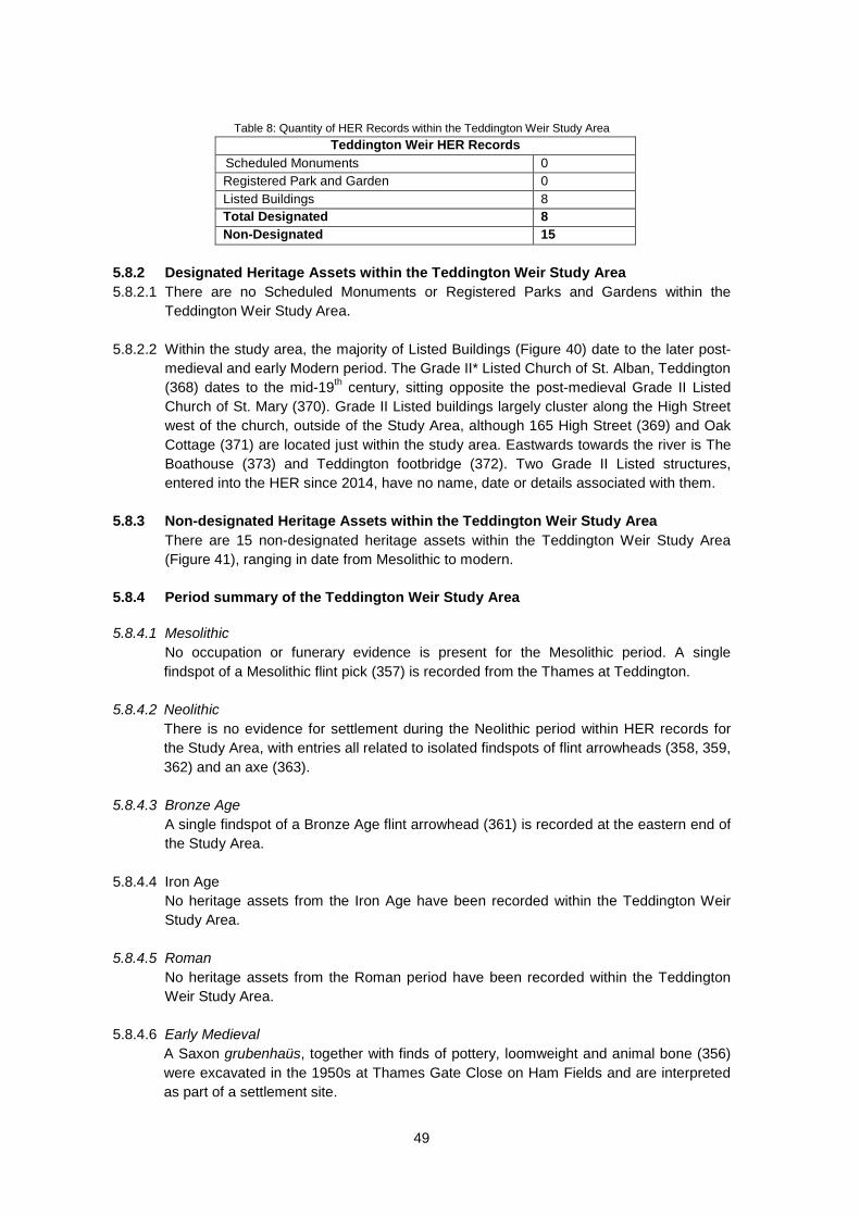
Table 8: Quantity of HER Records within the Teddington Weir Study Area
Teddington Weir HER Records Scheduled Monuments 0 Registered Park and Garden 0 Listed Buildings 8 Total Designated 8 Non-Designated 15
5.8.2 Designated Heritage Assets within the Teddington Weir Study Area 5.8.2.1 There are no Scheduled Monuments or Registered Parks and Gardens within the
Teddington Weir Study Area. 5.8.2.2 Within the study area, the majority of Listed Buildings (Figure 40) date to the later post-
medieval and early Modern period. The Grade II* Listed Church of St. Alban, Teddington (368) dates to the mid-19th century, sitting opposite the post-medieval Grade II Listed Church of St. Mary (370). Grade II Listed buildings largely cluster along the High Street west of the church, outside of the Study Area, although 165 High Street (369) and Oak Cottage (371) are located just within the study area. Eastwards towards the river is The Boathouse (373) and Teddington footbridge (372). Two Grade II Listed structures, entered into the HER since 2014, have no name, date or details associated with them.
5.8.3 Non-designated Heritage Assets within the Teddington Weir Study Area
There are 15 non-designated heritage assets within the Teddington Weir Study Area (Figure 41), ranging in date from Mesolithic to modern.
5.8.4 Period summary of the Teddington Weir Study Area 5.8.4.1 Mesolithic
No occupation or funerary evidence is present for the Mesolithic period. A single findspot of a Mesolithic flint pick (357) is recorded from the Thames at Teddington.
5.8.4.2 Neolithic There is no evidence for settlement during the Neolithic period within HER records for
the Study Area, with entries all related to isolated findspots of flint arrowheads (358, 359, 362) and an axe (363).
5.8.4.3 Bronze Age
A single findspot of a Bronze Age flint arrowhead (361) is recorded at the eastern end of the Study Area.
5.8.4.4 Iron Age No heritage assets from the Iron Age have been recorded within the Teddington Weir Study Area.
5.8.4.5 Roman
No heritage assets from the Roman period have been recorded within the Teddington Weir Study Area.
5.8.4.6 Early Medieval A Saxon grubenhaüs, together with finds of pottery, loomweight and animal bone (356) were excavated in the 1950s at Thames Gate Close on Ham Fields and are interpreted as part of a settlement site.
49

5.8.4.7 Medieval
A chapel (360) on Ferry Road is recorded to be medieval in origin. 5.8.4.8 Post-medieval
Five of the post-medieval heritage assets recorded relate to the listed buildings listed above (369-373). Teddington dock (365) and a water channel (366) are also recorded. Teddington Weir with its associated boat roller (374) are also mid-nineteenth century.
5.8.4.9 Modern
The Grade II* Listed church of St Alban (368) noted above, is listed as modern, as is an air raid shelter at Lensbury Club (367), the Teddington Red Cross WWI Hospital (462) and Teddington Footbridge on Ferry Road. A watching brief (E57) and subsequent evaluation (E55) have taken place at the Lensbury Club, although the results are unclear (Figure 42).
5.8.5 Conservation Area and Historic Landscape Characterisation within the Teddington Weir Study Area
5.8.5.1 The following Conservation Areas are located within or around the margins of the study
area (Figure 43):
• Broom Water • Kingston Fairfield/Knight's Park • Kingston Riverside North • Teddington Lock
5.8.5.2 Heritage statements for each conservation area are available from their respective
borough council websites (Richmond or Kingston Upon Thames). Focal points, views and vistas are described as contributing to the character in some of the appraisal documents but only in a few cases do these involve river vistas or views into which works might intrude. • Kingston Riverside North derives its character from its relationship with the river.
Views downstream from the northern end of the conservation area will include Teddington Weir and any significant alterations might be seen as affecting the character (but a well-designed scheme might be seen to have a positive effect).
• Broom Water conservation area in influenced by the landscape setting of the
riverside, but the focus is inward to the artificial inlet of the Thames rather than downstream towards the lock and weir.
• Teddington Lock and the weir itself are key parts of the conservation area. Any
significant alterations could be seen as affecting the character of the conservation area (but a well-designed scheme might be seen to have a positive effect).
5.8.5.3 The Greater London area has been subject to the process of Historic Landscape
Characterisation. As with Surrey County, this took place some time ago (2006) but it remains a potentially useful source of information regarding the character of any proposed development areas. However, the characterisation pays little heed to river
50

structures. Teddington Weir is split along the centre of the river between Ham Fields, 'rough land' to the north and Teddington Studios, 'commercial' to the south but not itself taken into account (Figure 44).
51

6 GEOARCHAEOLOGICAL ASSESSMENT 6.1 Introduction 6.1.1 A geoarchaeological assessment has been undertaken across the Study Area to assess
the impact that landscape evolution and associated geomorphological processes (particularly erosion and sedimentation) may have had on the preservation of cultural archaeological remains and any associated organic-rich sediments capable of providing proxy records of human impact, vegetation and climatic histories.
6.1.2 The review is based on information derived from a number of key data-sources:
• Information on solid and superficial geology was derived from mapping undertaken by the British Geological Survey (BGS) as well as geotechnical records supplied by the BGS borehole record archive.
• Identification and mapping of palaeochannel features was undertaken by Dr Samantha Stein, Trent and Peak Archaeology, from 2m resolution lidar data supplied by the Environment Agency and processed by Dr S. Malone of Trent & Peak Archaeology.
• Information on previous geoarchaeological research undertaken within the Study
Area and the immediate catchment was ‘mined’ from published monographs and journal articles.
6.2 Physiographic and Topographic Background 6.2.1 The Study Area is located in the Middle Thames Valley (Figures 1 and 2). Within this
zone, the contemporary river forms part of a classic low gradient, lowland river system carrying predominantly suspended sediments and solute load (Howard and Macklin 1999). Where channel engineering and other interventions have not been undertaken, the river is characterised by a single channel with stable, vegetated channel banks.
6.2.2 The recent floodplain sits 1-2m above the contemporary channel, but it is heavily
urbanised (Figure 3) and impacted by numerous areas of ground disturbance (e.g. gravel extraction and reservoir construction) (Figure 4); many of these areas are former quarries which have been restored to recreational lakes and wetlands, with some converted to landfill sites. In only a few localities can the relationship of the river to its floodplain be appreciated fully; for example, south of Datchet, around Runnymede and Hampton Court Park (Home Park). Where the floodplain is relatively unmodified, curving field boundaries and expanses of water provide indications of the former mobility of the river across its floodplain; for example, the features known as the ‘Engine River’ and ‘Broad Water’, which are located south of the ‘Desborough Cut’ near Shepperton.
6.2.3 Post-Medieval engineering of the channel, particularly associated with the construction
of weirs initially to aid navigation and trade, has resulted in the bifurcation of the river around numerous small islands within the Study Area, for example around the confluence of the Thames with the River Wey and River Bourne near Chertsey. More modern developments, for example, Penton Hook Marina near Egham Hythe, have further altered the plan form of the river.
52

6.2.4 The present tidal limit of the river is restricted to Teddington Lock, at the downstream limit of the Study Area.
6.2.5 The geological sequence and its formation is laid out in more detail in Section 4.2 above
together with consideration of its influence and relation to human exploitation and occupation of the valley and its resources.
6.3 Analysis of Landform Assemblages and Geotechnical Information 6.3.1 Mapping of Palaeochannels from Lidar
Lidar data supplied by the Environment Agency was processed by Trent & Peak Archaeology to allow the identification and mapping of former river channels within the Study Area (Figure 45). As mentioned in Section 1, the identification of such features is important since they have the potential to contain organic-rich sediments capable of providing proxy records of past climate, vegetation history and land use.
6.3.2 Despite the significant urbanisation of the Study Area and destruction of the natural
landscape as a consequence of quarrying, Figure 45 illustrates that a significant number of palaeochannel features can be mapped throughout the Study Area. The plan form of the majority of the features are of similar dimensions and wavelength amplitude to the form of the current channel of the Thames, which suggests that a significant number of these features represent former major channels of the main river. Other more minor palaeochannel systems can be correlated with tributaries such as the Colne Brook and River Ash.
6.3.3 Comparison of these features with available borehole records (Figure 48) demonstrate
that a number of these features may be associated with peat deposits (Figure 47), for example around Egham, Hampton Court Park (Home Park). Other organic records associated with palaeochannels appear to be associated with more minor tributaries draining into the Thames, for example, the River Ash and Colne Brook. Regardless of whether associated with a major channel of the Thames or a minor tributary, this data demonstrates that palaeochannels are preserved within the Study Area and in places, they will contain organic-rich sediments suitable for environmental reconstruction.
6.3.4 Section 4.2 described empirical evidence which suggested that during the early and
middle Holocene, the valley floor may have been characterised by an anastomosed river system (multiple but stable channels, interspersed with more extended areas of wetland). The record of palaeochannels recorded from lidar may well illustrate elements of such a system; however, at present, there are too few radiocarbon dates on discrete channel features to determine whether features observed across the floodplain of the Study Area are coeval and hence part of a larger channel complex.
6.3.5 Three Dimensional Reconstruction of Valley Floor Stratigraphy
Geotechnical information supplied by the BGS (Figure 46) has allowed the reconstruction of the three-dimensional sedimentary architecture of the valley floor within the Study Area. Selected elements of the entire geotechnical dataset were reviewed and on the basis of this analysis, three representative cross-sections were constructed perpendicular to the main valley floor in the upper, middle and lower parts of the Study Area (Figure 49). Broadly, the cross-sections illustrate around 1-3m of fine grained alluvium overlying coarser sands and gravels deposits of a number of discrete river terraces, between around 3-6m thick, but with local variation in lithology (see below).
53
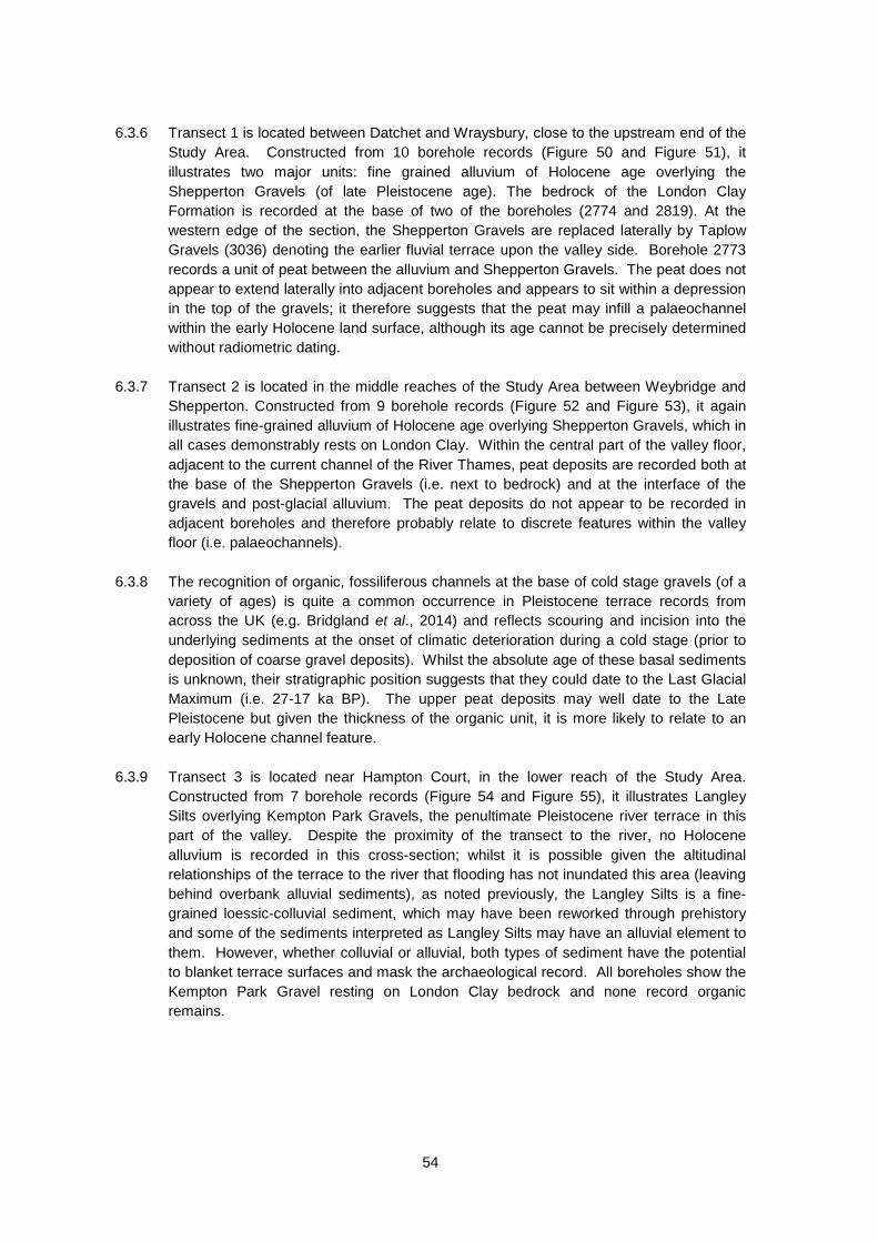
6.3.6 Transect 1 is located between Datchet and Wraysbury, close to the upstream end of the
Study Area. Constructed from 10 borehole records (Figure 50 and Figure 51), it illustrates two major units: fine grained alluvium of Holocene age overlying the Shepperton Gravels (of late Pleistocene age). The bedrock of the London Clay Formation is recorded at the base of two of the boreholes (2774 and 2819). At the western edge of the section, the Shepperton Gravels are replaced laterally by Taplow Gravels (3036) denoting the earlier fluvial terrace upon the valley side. Borehole 2773 records a unit of peat between the alluvium and Shepperton Gravels. The peat does not appear to extend laterally into adjacent boreholes and appears to sit within a depression in the top of the gravels; it therefore suggests that the peat may infill a palaeochannel within the early Holocene land surface, although its age cannot be precisely determined without radiometric dating.
6.3.7 Transect 2 is located in the middle reaches of the Study Area between Weybridge and
Shepperton. Constructed from 9 borehole records (Figure 52 and Figure 53), it again illustrates fine-grained alluvium of Holocene age overlying Shepperton Gravels, which in all cases demonstrably rests on London Clay. Within the central part of the valley floor, adjacent to the current channel of the River Thames, peat deposits are recorded both at the base of the Shepperton Gravels (i.e. next to bedrock) and at the interface of the gravels and post-glacial alluvium. The peat deposits do not appear to be recorded in adjacent boreholes and therefore probably relate to discrete features within the valley floor (i.e. palaeochannels).
6.3.8 The recognition of organic, fossiliferous channels at the base of cold stage gravels (of a
variety of ages) is quite a common occurrence in Pleistocene terrace records from across the UK (e.g. Bridgland et al., 2014) and reflects scouring and incision into the underlying sediments at the onset of climatic deterioration during a cold stage (prior to deposition of coarse gravel deposits). Whilst the absolute age of these basal sediments is unknown, their stratigraphic position suggests that they could date to the Last Glacial Maximum (i.e. 27-17 ka BP). The upper peat deposits may well date to the Late Pleistocene but given the thickness of the organic unit, it is more likely to relate to an early Holocene channel feature.
6.3.9 Transect 3 is located near Hampton Court, in the lower reach of the Study Area.
Constructed from 7 borehole records (Figure 54 and Figure 55), it illustrates Langley Silts overlying Kempton Park Gravels, the penultimate Pleistocene river terrace in this part of the valley. Despite the proximity of the transect to the river, no Holocene alluvium is recorded in this cross-section; whilst it is possible given the altitudinal relationships of the terrace to the river that flooding has not inundated this area (leaving behind overbank alluvial sediments), as noted previously, the Langley Silts is a fine-grained loessic-colluvial sediment, which may have been reworked through prehistory and some of the sediments interpreted as Langley Silts may have an alluvial element to them. However, whether colluvial or alluvial, both types of sediment have the potential to blanket terrace surfaces and mask the archaeological record. All boreholes show the Kempton Park Gravel resting on London Clay bedrock and none record organic remains.
54

6.4 Implications of the Geoarchaeological Record for the Study Area 6.4.1 Analysis of landscape evolution and the geoarchaeological record has important
implications for understanding the historic environment and in the design of appropriate mitigation strategies to alleviate the potential impacts of this flood scheme.
6.4.2 A number of Pleistocene river terrace sands and gravels are recorded at depth within
the Study Area. The Lynch Hill Gravel and Taplow Gravel may include composite deposits associated with major interglacials during Marine Isotope Stages 9 and 7, periods of known human activity, and palaeoliths, organic sediments and vertebrate remains have been recorded in these deposits. The Kempton Park Gravel has also yielded fossiliferous remains in discontinuous (organic-rich) channels indicative of both temperate and cold conditions during Marine Isotope Stage 3 (the Middle Devensian). This is a period when humans were known to have reoccupied mainland Britain following a prolonged absence (see Ashton and Lewis, 2002). The Shepperton Gravel is the altitudinally lowest terrace unit and is buried beneath the modern floodplain; it has been extensively quarried in the Study Area and shown to contain vertebrate remains and fossiliferous channels dated to between 15,000 and 10,000 years before present. Therefore, any interventions into these sediments need to be subject to appropriate assessment and potentially mitigation.
6.4.3 The Langley Silt overlies a number of river terrace aggradations and is interpreted as a colluvial (mass movement) deposit, though it may be primarily derived from loess (the deposit is historically referred to as a ’Brickearth’). Thermo-luminescence dating suggests that the main phase of deposition may have been around 17,000 years ago and the deposit has yielded Palaeolithic artefacts, vertebrate remains and a buried palaeosol has been identified in laterally equivalent deposits in the Colne Valley. Therefore, any interventions into these sediments need to be subject to appropriate assessment and potentially mitigation.
6.4.4 Early Holocene alluviation may have blanketed the undulating braid-plain topography of the Lateglacial river which deposited the Shepperton Gravels, and there is the potential for this early Holocene alluvium to mask Upper Palaeolithic and early Mesolithic sites that may have occupied higher areas within the valley floor such as former gravel islands.
6.4.5 Interpretation of lidar imagery has allowed the identification of a significant number of palaeochannels across the Study Area, relating to both the main Thames channel and some of its minor tributaries.
6.4.6 Comparison of palaeochannels with available geotechnical records indicates that a number of these features appear to contain peat and other organic deposits capable of preserving proxy records of climatic, vegetation and land use histories. Previous excavations at Runnymede have demonstrated the potential of these channels for environmental reconstruction. Therefore, any interventions into these features should be subject to appropriate assessment and potentially mitigation.
6.4.7 Selected humans remains (skulls) and semi-precious metalwork has been recovered from this part of the Thames and are part of a wider story of ritual deposition and other funerary activity associated with rivers and wetlands at various points in our history. Interventions, particularly adjacent to the river and within areas of discrete
55

wetland have the potential to yield such material and intervention-mitigation strategies need to take account of this.
6.4.8 Increased settlement activity on the valley floor from the Neolithic and the intensification of agriculture, led in part to increased soil erosion, waterlogging of the floodplain and the beginning of widespread alluviation, which increased during the Bronze Age, Iron Age, Roman and Medieval periods. This fine-grained alluvium initially blanketed the floodplain but has gradually extended across some of the higher terrace areas and has the potential to bury earlier archaeological features and remains, making them invisible to traditional methods of archaeological prospection (e.g. aerial photography and some geophysical methods). The potential for the presence of buried archaeological remains should therefore be considered even in apparently ‘blank’ areas.
6.4.9 Just upstream of the Study Area at Eton Dorney, continuous multi-period settlement activity from the Late Bronze Age through to the Medieval period has been found on the valley floor on a series of gravel islands separated by palaeochannels, which have yielded significant environmental evidence; these archaeological remains also include waterlogged wooden structural evidence of bridges and platforms, some associated with the deposition of votive material (including human remains). Eton Dorney demonstrates that relatively high water tables in some parts of the valley floor afford the potential for excellent preservation of wetland archaeological remains. Intervention-mitigation strategies need to take account of the potential for such deposits to survive in similar environments downstream.
6.5 Summary of Archaeological Site Investigations 6.5.1 The full archaeological profiles and archaeological results can be found in Appendix 5. 6.5.2 Site investigations of the RTS channel sections 1-3 were conducted in 2015 by WYG,
Fugro UK, and Opus. An archaeological watching brief was undertaken by TPA of test pits located in areas of potential archaeological sensitivity in Channel Sections 1 and 2 (see Appendix 5). Borehole and test pit data generated by the wider site investigations where an archaeologist was not present has been reviewed, but little information of archaeological interest was generated, as most of these were located on artificial and made ground.
6.5.3 The results of the archaeological watching brief revealed that, although not mapped as
such, the areas of potential archaeological sensitivity along Channel Section 1 were all composed of landfill waste. However, site investigations along Channel Section 1 are not yet complete, so there may still be potential for intact archaeological remains within the area north of the railway line (see Figure 1 in Appendix 5).
6.5.4 The watching brief along Channel Section 2 revealed deep stratified Holocene sediment
deposition with high environmental potential. Within these sediments were intact in situ archaeological remains. On the basis of the depths of stratified peats, sands, shells, silt alluvium, and terrace sands and gravels recorded during these ground investigations, and during previous borehole investigations by the BGS, a model of the palaeolandscape has been created (Figure 7 in Appendix 5). In the early Holocene this area was occupied by small islands within the River Thames originally formed by sand and gravel terrace islands, which were later exaggerated by alluvial deposition and peat formation. These islands would have been foci for human activity in sourcing plants, animals (including fish), and movement through the wetland. A charred post, found
56

within one of the test pits, pushed into the organic sedimentation confirms that archaeological remains are present beneath the recent alluvium in this area.
6.5.5 The negative results at Channel Section 1 have demonstrated that no archaeology
remains intact around the fields north and south of Station Road. There still is, however, a small possibility that archaeology is extant beneath the current landfill deposits, the base of which was not reached using the test pitting method. The archaeological site investigations of Channel Section 1 are not complete, as an additional field north of the railway requires test pitting, and there is a high likelihood of intact archaeological deposits at that location.
6.5.6 The area proposed for Channel Section 2 is rich with palaeoenvironmental information
and archaeological potential. Although the evaluation only included test pits, evidence of wetland archaeology (possibly prehistoric) is present in Test Pit 41 in the form of a charred post and additional strata indicative of archaeological potential. There is also much evidence of a wider palaeolandscape within the peat deposits that have filled in the palaeochannel detected around the proposed channel location. The potential for further palaeoenvironmental work should be thoroughly addressed in later stages of work.
57

7 MAP REGRESSION 7.1 Cartographic Sources
Searches of the Berkshire Record Office, Surrey History Centre and London Metropolitan Archives for map sources covering the proposed route have been made. These include early county maps, such as Rocque's maps of the 1750s, parish enclosure and tithe maps, and early editions of Ordnance Survey mapping. Maps have been georeferenced and presented as in Figures 56-82, with the proposed channel route overlain and accompanied by textual commentary, below.
7.2 Channel Section 1 7.2.1 The earliest map consulted for Reach 1 was the 1752 Rocque Buckinghamshire map
(Figure 56). Although relatively large scale it nonetheless shows some detail of road layout and settlement areas, including smaller hamlets and farms. The settlement of Datchet is clearly marked, just extending into the northern edge of the Study Area. The basic road pattern around Datchet is still identifiable today, with the current B376 Horton Road/Datchet Road/Welley Road marked on the 1752 map, although unnamed. The settlement of Wraysbury is also marked, within the southern end of Channel Section 1. As with Datchet, the basic road pattern is still identifiable today, with Staines Road, Wraysbury Road and Ferry Lane all present. The current B376 Horton Road/Welley Road also appears to be present. None of the roads are given names on the 1752 map. The course of the Thames has altered very little since the 1752 map, and many smaller tributaries are also marked on Rocque’s map, which are still present today. A bridge is marked across the Thames, at the very northern end of the Reach, which appears to lead to/from Datchet. A number of buildings are also shown around the area that is now called Hythe End, at the southern end of Channel Section 1, although this remains unnamed on the map, being only a very small settlement at this time. With the exception of Wraysbury and Hythe End, very little development is present within the Channel Section 1 Study Area in 1752. A small collection of buildings is shown at the very northern end of Channel Section 1, just to the south of the bridge over the river, but these are unlabelled and their function remains unclear. From the evidence of this earliest map, it appears that the majority of Channel Section 1 comprised enclosed fields at this date.
7.2.2 The 1799 map of Horton (Figure 57) covers only a small central area within Channel Section 1, and is the earliest detailed map consulted for the area. A small area at the northern end of Channel Section 1 is depicted on the map as Deeplake Common and Welby Common. The majority of the land is marked as owned by Thomas Williams Esq. The north-south aligned Coppermill Road is present on the map, along with the similarly aligned River Colne to the west of it. Horton Moor is marked surrounding Coppermill Road. Very few buildings are marked on the map, with only a small cluster to the south of Deeplake Common. A large area called High Croft is marked to the west of Deeplake Common.
7.2.3 A plan of Wraysbury, dated 1800 (Figure 58), covers the southern two-thirds of Channel Section 1. The settlement of Wraysbury is clearly identifiable. Welley Road, the current B376, is established at this time. The town of Wraysbury is depicted in some detail, with individual buildings represented. At this time, the town itself was clustered around High Street/Station Road, with buildings generally only on the southern side of the road. The town extended out towards the west, beyond the boundary of the Channel Section 1 Study Area. Staines Road is also depicted on this map, again with buildings along it, this time arranged to either side of the road, although rather sparsely. A small settlement at
58

the current Hythe End is also depicted, although not named, as observed on the 1752 map. Around this area a large building is marked on the River Colne, just to the north of the River Thames; this is not named, but may be the location of a mill.
7.2.4 The 1811 Ordnance Survey drawing (Uxbridge to Windsor) is relatively large scale and does not show any evidence of change from the 1800 map, although unlike the 1799 and 1800 maps, it does cover the entire Channel Section 1. The buildings within Wraysbury are still depicted on the southern side of High Street/Station Road. The vast majority of Channel Section 1outside of the settlement of Wraysbury remains undeveloped at this time, with fields interspersed with small tracks and drains. A structure named Southley House is located at the very northern end of the Channel Section 1with Southley Farm a short way to the south. A workhouse is also located at the northern end of Channel Section 1, just to the south of Datchet.
7.2.5 The Old Windsor map of 1817 lies mostly outside of Channel Section 1, although a small section does extend into the southern edge of the Study Area. This shows that to the south of the river, a small area of land belonged, or was leased out to, Queens College. This parcel of land is still recognisable today, and is marked on modern maps as Ham Island.
7.2.6 The 1833 Datchet map (Figure 59) covers the northern third of Channel Section 1 only.
The current B376 Horton Road is marked as a Public Carriage Road. The fields are arranged into irregular sizes and shapes, some being large squares and rectangles, others being more obscure and smaller shapes. The majority of field boundaries observed on the 1811 map remain, with the addition of some extra ones. The land at the northern end of this section is collectively called Marsh Field, to the east of which is an area called The Fleet. A footpath is shown aligned approximately north/south between Marsh Field and The Fleet, which was not depicted on earlier maps. This is noted as being 5 feet wide. The drain which currently runs to the immediate west of Welley Road is labelled The Fleet Drain. There are very few buildings at the northern end of the Channel Section 1 Study Area at this time, with the majority of the area split into irregular fields. Southley Farm is still present, as are the small cluster of buildings first identified on the 1752 Rocque map, on the river bank, to the south of the bridge.
7.2.7 The 1840 Wraysbury Tithe Map (Figure 60) demonstrates expansion within Wraysbury
since the 1811 map, with the buildings to the southern side of High Street/Station Road expanded a little further to the south, and some buildings also present on the northern side of the road. The land to the north of the High Street remained undeveloped fields, as did the immediate area to the south, with drainage. Additional buildings had been constructed along the current Staines Road, which is un-named on this map. A cluster of buildings were present around the current Dearsley Island, at least one of which may be a mill, as some appear too large to be dwellings.
7.2.8 A small section on the south bank of the Thames in the southern end of the Channel Section 1 Study Area is covered by the 1841 Egham tithe map. The current Windsor Road is depicted, as is The Glanty, although both are unnamed on the map. The strip of land between the current Windsor Road and the river is split up into numerous smaller plots, the boundaries of which may still be present today.
7.2.9 The 1872 map of the River Thames (Archive reference: ACC/0809/MP/51a) (Figure 61)
depicts noticeable change in the Channel Section 1 Study Area, with the creation of the Windsor Branch South Western Railway (S.W.R.) railway line, aligned approximately
59

northwest to southeast, with a station located just to the north of Wraysbury. As with previous maps, the main focus of the settlement in Wraysbury lies to the south of the High Street. A lock is shown on the Thames, at the very southern end of this section, and Bell Weir is marked at the southern end of the River Colne, just before it joins the River Thames.
7.2.10 The 1881 OS County Series 1:10560 for Middlesex (Figure 62) marks the supposed remains of St Helen’s Monastery at the northern end of the Channel Section 1 Study Area, just below Southlea Farm. These remains are not identified on the earlier maps consulted. The garden walls around the site are currently Grade II Listed (94) and described as 17th century, part rebuilt 18th century and later. This map also shows the Windsor Line of the London and South Western Railway, aligned north-west to south-east through the northern two-thirds of this section. An Old Workhouse is located at the northern end of the Study Area, just to the south of the main core of Datchet, in the same location as the Workhouse identified on previous maps. Datchet Mill is depicted just to the east of the workhouse, off the current B376 Horton Road. Welley Farm was located at the junction of the current Horton Road and Welley Road, with Kingsmead Farm located a little the south, near the junction of Welley Road and the railway line. To the north of Wraysbury, no other development is evident, with vast majority of the area comprising fields, the boundaries of which are still recognisable from the older maps. The settlement of Wraysbury itself appears little changed from the 1840 tithe map, with perhaps a few additional buildings, but no major development. The settlement of Hythe End is labelled on this map. The large building on the River Colne noted on the 1840 tithe map is labelled as Hythe End Paper Mill at this time. A lock is depicted on the River Thames, at the junction with the River Colne. A chemical works was present at the southern end of Channel Section 1, on the south bank of the river.
7.2.11 The 1926-1932 OS County Series 1:10560 for Surrey (Figure 63) shows further additions to Southlea Farm and the addition of a further house north of the monastery site (but removal of some other small structures to the west). Southlea Farm itself is still present at this time, and the cluster of buildings in the location first identified on the 1752 map, on the river bank just to the south of the bridge, had extended quite considerably by the time, collectively labelled as Southlea. The Old Workhouse is no longer labelled, although it is possible that the building was still present at this time, included in a small cluster of buildings labelled as Home Farm. Datchet Mill is also no longer labelled, although again is likely to still be present, now labelled as Mill Place. Welley Farm, at the junction of Horton Road and Welley Road, is still present, as is Kingsmead Farm. Substantial development towards the southern end of Welley Road had occurred by this time, with sludge beds created in the bend of the river by Ham Fields. A new railway station had been built at the junction of Welley Road and the railway line, with a cluster of houses built between the river, the railway line and Welley Road, labelled Sunnymeads. A large sand and gravel works had been created to the south of this, between the railway line and the river. There is little evident change within Wraysbury itself, although numerous sand and ballast works had been created to the immediate south of Wraysbury. The chemical works depicted on the 1881 map was at this time a Varnish Works, and numerous structures had been built opposite this, on the northern side of the river. The settlement of Hythe End had expanded slightly by this time, although the paper mill was no longer present. Bell Weir is instead marked in its location, with a gravel pit to the immediate east. Bell Weir is in a different location to that marked on earlier maps; whether this is an error, or the weir had been rebuilt, is unclear. A cutting is depicted directly to the south of the gravel pit, which is currently a drain. A greyhound track was located to the south of the new cutting, between it and the
60

Thames. Bell weir Lock and a weir are depicted on the Thames, at the junction with the River Colne, along with the Angler’s Rest public house.
7.2.12 Modern OS mapping shows that the town of Datchet has extended into the northern end of the Channel Section 1 Study Area, occupying what were previously fields, between the railway line and Southlea Road. The small cluster of buildings in Southlea is still present, as is Southlea Farm. A small water channel has been created from the Thames, on the south-east alignment, running to the southern end of Datchet, where it terminates at a water intake. The site of St Helen’s Monastery is no longer depicted, although in its location are Monastery Cottages. The area at the northern end of this section, to the north of Ham Island, between the railway line and the river, appears to have remained relatively undeveloped, the only change being the addition of a few field boundaries. To the south-east of Datchet, Channel Section 1 has undergone drastic change since the 1932 OS map, with large water bodies occupying the majority of the Study Area. Many of these fill the gravel pits identified on the 1932 OS maps, although some are new. The town of Wraysbury remains, surrounded by large water bodies. At the southern end of Channel Section 1, recent development along either bank of the Thames, and around Hythe End and Dearsley Island, plus the construction of the A30, has left very little land undeveloped.
7.3 Channel Section 2 7.3.1 The earliest map consulted for Channel Section 2 was the 1752 Rocque Map of
Buckinghamshire (Figure 64). The current A320 Staines Lane/Chertsey Lane is shown, as are the current Green Lane and Norlands Lane, although none of the roads are named on the 1752 map. A number of small streams/drains are also depicted running through this section. Very little other development is evident, with the majority of the reach comprising irregular enclosed fields. The settlements of Thorpe and Chertsey are marked on the map, although the core of both lie outside the Channel Section 2 boundary, with only the edge of the settlements spreading into the western edge of the Study Area.
7.3.2 The 1804 Ordnance Survey drawing (Hampton Court) covers the southern end of
Channel Section 2 only. (Chertsey) Abbey is marked near the southern end, with Abbey Mill a little to the south-east of it. The remainder of the area is depicted as fields.
7.3.3 The 1816 enclosure map for Laleham Burway (DRO 021 091) covers an area within the
southern half of Channel Section 2, split into several strip fields. The current Ferry Lane is depicted, although appears to have a different name, which is illegible on the map.
7.3.4 The western end of Monks Walk (178) appears to be depicted on the Thorpe tithe map of c.1840 (Figure 65), although it is not labelled as such. The map also depicts many of the current roads included in the Channel Section 2 Study Area, including the A320 Chertsey Lane, Green Lane, and Norlands Lane, although none of these are named. Two roads are shown running south from Norlands Lane, which are no longer present, located in the area of the current Thorpe Park theme park. Very few structures are shown within this section on this c.1840 map, with only a small cluster around what is now the junction of Coldharbour Lane and Norlands Lane, none of which still appear to be present.
7.3.5 The 1841 Egham tithe map covers only a small northern section of the Channel Section
2 Study Area. As with the Thorpe tithe map of c.1840, Chertsey Lane is also marked on this map. The remainder of the map depicts fields with no structures present. The vast
61

majority of the field boundaries now appear to have been removed, but those that remain respect the boundaries depicted on this 1841 map.
7.3.6 The 1844 Chertsey tithe map (Figure 66) covers the southern end of the Channel Section 2 Study Area. The plan is partial with much land and property clearly exempt from tithes and excluded. However, development on the northern side of the town, and in the grounds of the former abbey, seems not to be extensive at this date (with the exception of Colonel’s Lane/Ferry Lane). None of the remains relating to the abbey which are present on current mapping (e.g. earthworks, gate, chapel, fishpond, black ditch, abbey remains) are identified as such, although the Black Ditch and associated moats and fish ponds appear to have survived well at that date. The majority of the Study Area covered by the map is shown as fields with numerous drains running through them, most of which are still present today. The current area of Abbey Mead remains divided in much the same way but now bisected by the line of the M3.
7.3.7 The 1872 map of the River Thames (ACC/0809/MISC/51b) (Figure 67) covers the majority of Channel Section 2, although lacks detail away from the river. The Abbey River is depicted running south from the Thames, and the location of Abbey Mill is also depicted. A lock is represented at the very southern end, on the Thames. The lock is also present on the 1886 Angler’s Map of the Thames (ACC/0809/MISC/52), named Chertsey Lock, as is the mill.
7.3.8 The 1878-1881 OS County Series 1:10560 for Surrey (Figure 68) depicts much of the northern end of Channel Section 2 as still undeveloped, comprising mainly enclosed fields. The settlement of Thorpe extends into the western edge of the Channel Section 2 Study Area, although this mainly appears to comprise small orchards and allotments rather than built structures. A small area of strip fields is depicted in the central eastern edge of the Study Area, around Laleham Burway, the boundaries of which appear unaltered from the 1816 Laleham Burway enclosure map. Towards the southern end of Channel Section 2, the edge of Chertsey extends into the Study Area. The site of the Abbey is depicted, as is the Abbey Mill, which is marked as a flour mill at this time. Monks Walk (178) may also be represented, although, if so, it is depicted as a tree/ hedge boundary rather than a footpath/ road.
7.3.9 Significant development had occurred in the northern end of the Channel Section 2 Study Area by the time of the 1938 OS County Series 1:10560 for Surrey (Figure 69), with numerous new houses constructed off both sides of the current A320 Chertsey Lane. Occasional small gravel pits are marked to the west of the northern end of this section. The area between Thorpe and Chertsey remained undeveloped at this time, and comprised enclosed fields interspersed with some drainage. The strip fields at Laleham Burway were still present, with a golf course immediately to the north of them, mostly situated outside of Channel Section 2. A water pumping station had been established immediately to the south of the strip fields. Within Chertsey, at the southern end of the Study Area, numerous points of interest are identified, including the site of the Abbey, two stone coffins, the remains of a chapel, a moat, and Abbey Lodge. A building at the site of the Abbey Mill is depicted, labelled Abbey Chase. A large area called Abbey Mead, to the north of Chertsey, remains as undeveloped fields, as does the area to the east of the river, with the exception of a sports ground located at the southern end. Monks Walk (178) is depicted as a footpath; although it is not labelled as Monks Walk, or given any other name.
62

7.3.10 Modern OS mapping shows further development within the northern area of the Channel Section 2 Study Area, with additional houses, drains and water bodies, including Fleet Lake, constructed since the 1938 map. Within the central area of the site, Abbey Lake and Manor Lake have been constructed, as well as Thorpe Park theme park. The strip fields of Laleham Burway have been replaced by a golf course. The entire middle section of the Study Area has either been intensively developed with structures, or given over to water bodies. The southern end of this section has been altered notably by the construction of the M3 motorway, which is present on a north-west to south-east alignment. At the extreme southern end, to the east of the river, two large water bodies have been constructed, although apart from this much of the southern end remains undeveloped, notably the area named Abbey Mead. The small area of Chertsey which extends into the Study Area is of interest, due to the Abbey, chapel and associated remains which are still marked on current OS mapping. Earthworks are depicted on modern mapping within the area of Abbey Mead, which, given their proximity to the Abbey and associated structures, are likely to be related.
7.4 Channel Section 3
7.4.1 The 1754 Rocque Map of Middlesex (Figure 70) depicts many of the current roads, including Chertsey Bridge Road, Chertsey Road, and Sheepwalk, although these are all unnamed on the map. The settlement of Shepperton extends into the northern area of the Channel Section 3 Study Area, but aside from this, this section appears to comprise solely enclosed fields.
7.4.2 The 1804 Ordnance Survey drawing does not show any evident change, with the Channel Section 3 Study Area still largely undeveloped. The 1813 Map of Tithable Land in Parish of Shepperton (DL/TA/A/39/A) (Figure 71) also shows very little development within the Study Area away from Shepperton. The field boundaries alter somewhat from the 1804 Map, but otherwise little change is evident. The 1843 Shepperton Tithe Map (ACC/1218/29) shows no change from the 1813 Map of Tithable Land in Shepperton. An undated map from the 19th century (MJ/SP/B/1038) again shows no change from the 1813 map, with identical field boundaries.
7.4.3 The 1841 Plan of the Parish of Shepperton (ACC/1218/276) (Figure 72) shows some change in the field boundaries to the south of the current Chertsey Road, with smaller rectangular plots replacing the larger irregular plots depicted on earlier maps. The remaining field boundaries remain unchanged from the 1813 map. A small pumping station had been established at the southern end of the Reach, on the southern side of the current Walton Lane. Little further change is depicted, although detail is added to the settlement of Shepperton, which includes a Manor House and Rectory. Both of these buildings appear to be present on earlier maps, but unlabelled.
7.4.4 The 1848 Littleton tithe map shows the current Littleton Lane and Chertsey Bridge Road as present, although both are unnamed. The land in the Channel Section 3 Study Area that is covered by the map is arranged into irregularly sized fields; the vast majority of these boundaries have since been lost to the north of the current M3, with the creation of a large lake and several infilled gravel pits. To the south of the current M3, some of the current field boundaries are recognizable from this 1848 map, although some have been removed or altered. There are no structures depicted within the Study Area on the 1848 Littleton tithe map.
7.4.5 The 1862 Map of Common Lands of Shepperton (ACC/1218/66) shows very little change from the 1841 parish plan, with the exception of the addition of a handful of field
63

boundaries. The 1898 Map of Shepperton (ACC/0809/319) again shows little change in the area.
7.4.6 The 1872 OS County Series 1:10560 for Surrey and Middlesex (Figure 73) shows little development in the western end of the Channel Section 3 Study Area at this time. There had been some rearrangement of field boundaries, but very little in the way of development. The same applies to the eastern end of the Study Area, with little change evident from the earlier maps. The 1929 map (ACC/0809/MP/054) shows little detail away from the river, although does mark the location of a proposed new cut at the very southern end of this section.
7.4.7 The 1934-1938 OS County Series 1:10560 for Middlesex and the 1938 OS County Series 1:10560 for Surrey (Figure 74) also show little change. An irregular pit had been established at the junction of Chertsey Road and Sheepwalk, and some new structures had been established at the southern end of the eastern half of the Channel Section 3 Study Area, along Towpath and Ferry Lane. Aside from development around the established road network, the majority of the Reach at this time remained undeveloped, enclosed fields.
7.4.8 Current OS mapping shows that the northern end of the Channel Section 3 Study Area has been truncated by the east to west aligned M3 motorway, to the north of which has been occupied by a large lake belonging to the Littleton Sailing Club, a large industrial estate and a water-filled gravel pit. A small pocket of development has occurred within the centre of this section, with the Waymeadows Business Centre, but generally the central area remains undeveloped, with some remaining field boundaries identifiable on the earlier nineteenth century maps. A large body of water has been established at the southern end of the Study Area, but apart from this, the area again comprises enclosed fields, some of the boundaries of which are identifiable on maps from 1804 onwards.
7.5 Desborough Cut
7.5.1 On the 1754 Rocque Map of Middlesex (Figure 70), the area to the south of the river is called Walton Mead. Little detail is depicted in this area, due to it being located at the very edge of the map. The 1804 Ordnance Survey drawing shows the current Walton Lane and the track to the south of it, along with Oatlands Drive at the very south-eastern end of the Reach. The area to the south of the river, named Walton Mead on the 1754 map, is named Weybridge Mead on the 1804 map, and is depicted as a group of fields. To the south of the current Walton Lane was an area of strip fields. The two areas to the north of the river are also shown as enclosed fields.
7.5.2 The 1813 Plan of the Tithable Land in the Parish of Shepperton (DL/TI/A/039/A) (Figure 71) shows some boundaries on Desborough Island but no detail along the subsequent course of the Cut. To the north of the river, the current field boundary of Thames Meadow is also shown. The 1841 Plan of the Parish of Shepperton (ACC/1218/276) (Figure 72) shows the current Walton Lane as Weybridge Lane. The area to the north of the river is shown as fields, unchanged from the 1804 map. Between the river and the current Walton Lane, the area of the current Desborough Island retains the field boundaries which are partially depicted on the 1813 map. The eastern half of this plot of land contains various filter beds and reservoirs. To the south of Walton Lane, between it and the Engine River, are a number of enclosed fields. Little development is evident within the Study Area at this time, with the exception of the western end, to the south of Walton Lane, where a number of small buildings are present, which appear to be houses.
64
7.5.3 The 1843 Shepperton Tithe Map (ACC/1218/29) only depicts the area to the north of the
river, which remains unchanged from the 1841 map. 7.5.4 The 1872 OS County Series 1:10560 for Middlesex (Figure 73) shows little change from
previous maps. The field boundaries remain unchanged from the 1841 map, with the loss of a small number of field boundaries at the southern end of the reach. The filter beds and reservoir which were located between the river and Weybridge Lane are not depicted on this map, although this is likely to be an omission as they do feature on all subsequent maps.
7.5.5 The 1929 Thames Conservancy Plan (ACC/0809/MP/054) shows the route of a proposed new cut, which is now the current Desborough Cut. Walton Lane is still named Weybridge Lane at this point. The area of filter beds and reservoirs is named the West Surrey Water Works. Little further detail appears on this map for the remainder of the reach, as the detail focuses on the river more so than the surrounding land.
7.5.6 The 1934-1938 OS County Series 1:10560 for Middlesex (Figure 74) again shows little development within the Study Area, with the majority of the existing field boundaries remaining. The area to the north of the river at the western end of the cut had been cleared of existing field boundaries, as it had at the eastern end, with what appear to be the beginning of housing plots established along the river bank. The new cut outlined on the 1929 map appears to be in progress (on subsequent maps revised from 1938 onwards it is shown to be complete). On the southern edge, towards the eastern end, some houses had been established along the current Oatland Drive. The majority of the Study Area remains undeveloped at this time, with the field boundaries observed on earlier maps still present.
7.5.7 Current OS mapping shows the majority of the Study Area still undeveloped, with field boundaries identified on early mapping still present. The only obvious development is the water treatment works, first observed on 1841 map. The area of the land to the north of the Thames at the western end of the Study Area is currently depicted as a body of water, possibly associated with a sailing club, which is located just to the north of it. To the south of the Thames at the eastern end is a small area of housing, first identified on 1841 map, but slightly larger now. The majority of this area retains historic field boundaries, with little evidence of development since at least 1754.
7.6 Sunbury Weir 7.6.1 A map of Sunbury dated 1848 (DRO/007/J/01/001) shows the weir already in situ
(Figure 75) by this time, although lacks detail. The 1871-1881 OS County Series Surrey 1: 10560 (Figure 76) depicts Sunbury Weir as a continuous straight structure, positioned across the river approximately on a north-east to south-west alignment. The structure is labelled simply as ‘weir’. To the east of the weir is a pub, the New Inn, on the river bank. The core of Sunbury is clearly identifiable at the northern end of the study area.
7.6.2 The 1884 OS County Series Middlesex 1:10560 shows the weir as unchanged from the
1871-1881 map, although the 1896 OS County Series Middlesex 1:2500 (Figure 77) shows that the south-western end of the weir had been altered so that a right angled return to the north-west had been formed, to allow the weir to join the bank further to the north than the straight weir shown on earlier maps. The structure is labelled for the first time as ‘Sunbury Weir’ rather than just ‘Weir’ as on the earlier maps, and also for the first time a footbridge is labelled across the top of the weir, possibly built into/over the
65

weir during the re-alignment works which appear to have taken place sometime between 1184 and 1886. By 18863 the New Inn had altered its name to the Weir Hotel.
7.6.3 By 1958, further alteration works appear to have occurred on the weir, with the main north-east to south-west alignment shown as having a dog-leg approximately half-way along its length on the OS Town Plan 1: 2500 of 1958 (Figure 78). On earlier maps the alignment was depicted as totally straight. The previous available map for consultation before the 1958 map was dated to 1938, suggesting the works occurred at some point during those 20 years.
7.6.4 Within the study area in general, gradual development appeared to occur between
1871-1920, with the addition of new buildings around Sunbury, expanding the settlement area. By the 1934-1938 OS County Series Middlesex 1:2500, the area right up to the river bank on the northern side of the river had been developed, which had further expanded by 1958. The area of the river bank to the south has always remained fairly undeveloped, with the exception of the Weir Hotel, and remains so today. Current OS mapping demonstrates that although significant development had occurred within the Study Area since the 1871 OS map, particularly around the fringes of Sunbury, these have tended to respect the land boundaries present on the 1871 map.
7.7 Molesey Weir 7.7.1 The 1868-1894 OS County Series Surrey 1:2500 depicts Molesey Weir (Figure 79),
although it is not labelled. The weir is shown on a north-west to south-west alignment, the north-western end joining with an island in the middle of the river, and the south-eastern end joining with an island along the southern bank of the river.
7.7.2 The 1871 OS County Series Surrey 1: 10560 shows the weir as unchanged from the
earlier map, although it is labelled as ‘weir’. The 1880-1893 shows the weir as unchanged, although the 1896-1898 OS County Series Surrey 1: 2500 shows modifications to the weir (Figure 80). The northern end of the weir had been altered significantly by this time, with a right-angled dog-leg leading into the island in the centre of the river. It is possible that the entire weir structure was replaced, as it appears on a slightly different alignment to earlier maps (although not drastically), and the prominent structures at either end of the weir have been removed. A footbridge is also labelled across the weir for the first time on this map, probably added at the time of restoration between 1893-1898.
7.7.3 By 1956 a line of posts, immediately upstream of the weir, had been added by this time.
Modern OS maps show the weir to be unchanged from the 1956 map. 7.7.4 Within the study area, the area to the north and west of the weir largely comprises fields
in 1868 (Figure 79). To the east lies Hampton Court Palace, and to the south is a small area of development, labelled Kent Town. By 1896 some buildings had been established to the immediate north and west of the weir, many labelled as boat houses (Figure 80). The area to the south of the weir, previously labelled Kent Town, was by 1898 labelled East Molesey, and expanded gradually throughout the early twentieth century to reach the southern bank of the river.
7.8 Teddington Weir 7.8.1 Teddington Weir is depicted on the 1850 OS Town Plan of London 1: 5280. Although
lacking in detail, the weir is clearly shown on a single, straight north-west to south-east
66

alignment, stretching from the southern bank of the river across to an island in the middle of the river. This remains unchanged until the OS County Series London 1896 1:10560 map (Figure 81), which shows that an alteration had been made at the northern end, to create a dog leg return to the west, altering the previous dead straight alignment of the weir.
7.8.2 The 1896 OS County Series Middlesex 1:2500 shows a sluice fitted on the upstream
edge of the weir. This is not shown on the smaller scale map of the same date, and is likely to be part of the alteration works at the northern end of the weir, although this detail is only shown on the larger scale map. By 1915 a small section of weir had been created within the island in the river, but was not joined onto the main weir.
7.8.3 The 1934 OS County Series Surrey 1:2500 shows that by this time, the southern end of
the weir had been re-aligned, to create a southern return into the river bank (Figure 82), where before it had returned to the bank and a south-eastern alignment. By the 1959 OS London Plan 1:1250, the small isolated section of weir which was first present on the 1915 plan had been extended, to join on to the main weir. The weir appears to have remained unchanged since.
7.8.4 Within the study area, the area to the north of the weir comprised open fields in 1850,
labelled Ham Fields. A small amount of development had occurred here by 1871 to the north-east of the weir, with the areas to the south and west of the weir partially developed by the area of Teddington. By 1896 (Figure 81), significant development had occurred to the south of the river, with Teddington expanding. The area to the north was still largely undeveloped at this time, with the small development to the north-east of the weir labelled as Ham. By 1934 (Figure 82) the area to the north of the weir has become slightly more developed with houses, which had expanded considerably further by 1959. Modern OS maps show the area to be largely unchanged since this time, with only a small area to the north-west of the weir remaining undeveloped.
67

8 SITE VISITS AND SETTING
8.1 Site visits 8.1.1 Site visits were undertaken in order to assess current ground conditions along the route
and to identify any factors which might affect the survival or condition of known or potential assets, including potential setting issues relating to designated assets within the 500m Study Areas. The entire route was not walked, but access obtained at various points along its length sufficient to establish the current character of each area. All designated heritage assets within the corridor buffer were visited and their setting in relation to the proposed channel diversion route assessed. More detail and photographic record is provided in Appendix 6.
8.1.2 South of Datchet, Channel Section 1 crosses the flat floodplain, here comprising
enclosed fields bounded by mature hedgerows, variably pasture or under arable cultivation. Passing east of the railway, and either side of Welley Road, Horton it passes through a landscape of worked-out gravel pits largely retained as tree-fringed water-bodies, although some areas of former landfill are now grassland and scrub. The same pertains passing south of the railway line again at Wraysbury to Staines Road and the River Thames adjacent to Runnymede Weir at Hythe End.
8.1.3 From the River Thames at Egham Hythe, Channel Section 2 crosses grassland and
wooded areas on Thorpe Hay Meadow, turning south, once again through a landscape of worked-out gravel pits, north-east of Thorpe reinstated as landfill, south of Norlands Lane retained as water bodies (Fleet Lake, Abbey Lake). Further water bodies occupy the area east of Staines Road, but beyond Ferry Lane the pasture land of Abbey Mead survives retaining its mature hedgerow boundaries (but bisected now by the line of the M3 motorway).
8.1.4 The Channel Section 3 inlet cuts through a small section of riverside meadow south of
Abbey Bridge Road but thereafter the course is almost entirely within worked-out gravel pits reinstated as landfill north-west and south-east of Mead Farm but otherwise retained as extensive tree-fringed water-bodies including the large lagoon south of the historic core of Shepperton.
8.1.5 The Desborough Cut flows through regular fields on the valley floor to the south of the
Cut. To the north of the Cut are further fields and a large water treatment plant. In comparison to the Study Areas of Channel 1 to 3, the Desborough Cut Study Area is largely unpopulated, with few structures within it. None of the designated assets within the Desborough Cut Study Area, which comprise the Registered Park and Garden of Oatlands (282) and five Listed Buildings, are thought to have good visibility to the proposed works. Where there is visibility, it is highly restricted by surrounding mature tree and standing buildings.
8.1.6 The Sunbury Weir Study Area includes the historic core of Sunbury to the north of the
river, whilst the south remains largely undeveloped. From the northern river bank, views to the weir are highly restricted by private residences fronting onto Fordbridge Road/Thames Street, and the cluster of Listed buildings within this Study Area, and the Lower Sunbury Conservation Area, are largely shielded from view of the weir. The sound of the weir could not be perceived from the Listed buildings or the closest edge of the Conservation Area. Views of the weir from the southern bank are less restricted by existing buildings, although a line of mature trees along the river bank does provide a screen.
68
8.1.7 The Molesey Weir Study Area is prominent from the southern river bank, with a large
public footpath running alongside it. The weir itself is located at the edge of the East Molesey Kent Town Conservation Area, although the view from within the Conservation Area towards the weir is largely screened by a row of mature trees running along the edge of the southern river bank; the weir is only visible from within the East Molsey Kent Town Conservation Area when stood directly adjacent to the weir, on the river bank. As such, the proposed works will have little impact on the setting of the vast majority of this Conservation Area as the works will be screened from the majority of it. The Conservation Area is fairly urban with a busy road running through it, hence any noise from the works is unlikely to impact the setting either. Views to/from this Conservation Area will remain unaffected once the work is complete. Public views from the northern river bank are largely irrelevant, as the private residences fronting onto the A308 Hampton Court Road completely screen the weir from view from this river bank. This screens the Conservation Areas of Hampton Court Green and Bushy Park from the weir. The weir could not be heard from these Conservation Areas during the site visit. The weir is partially included in the Hampton Village Conservation Area, although again the weir was not publically visible from this Conservation Area due to private residences along the A308 Hampton Court Road. The proposed works will have little impact on the setting of this Conservation Area, and generally the weir is shielded from view, although from areas where it can be viewed (from private residences or boat clubs), the impact of the proposed works will be minimal, and once the works are complete, the setting should remain unaffected.
8.1.8 Teddington Weir is situated within the Teddington Lock Conservation Area. The weir
itself is a large structure over a wide stretch of river and is prominent from the immediate river bank on both sides. On the southern side of the river, views of the weir immediately away from the river bank are mostly obscured by a modern industrial estate and sports ground. To the north of the river, immediately away from the river bank, the weir is shielded by abundant mature trees.
To the south-east of the Study Area is the Broom Water Teddington Conservation Area. Generally, the weir cannot be seen or heard from within this Conservation Area, except from immediately on the river bank, where the weir may be viewed at a distance downstream.
8.2 Setting
8.2.1 The setting of a heritage asset is the surroundings in which a heritage asset is
experienced (Historic England, 2015). Elements of a setting may make a positive or negative contribution to the significance of an asset, may affect the ability to appreciate that significance or may be neutral. Its extent is not fixed and may change as the asset and its surroundings evolve. Setting is the context of a heritage asset and can include noise, physical links and land use as well as views.
8.2.2 The contribution of setting to the significance of a heritage asset is often expressed by reference to views, a purely visual impression of an asset or place which can be static or dynamic. This can include a variety of views of, across, or including that asset, and views of the surroundings from or through the asset, and may intersect with, and incorporate the settings of numerous heritage assets.
69

8.2.3 Views which contribute more to understanding the significance of a heritage asset include:
• those where relationships between the asset and other historic assets or places or natural features are particularly relevant
• those with historical associations, including viewing points and the topography of battlefields
• those where the composition within the view was a fundamental aspect of the design or function of the heritage asset,
• those between heritage assets and natural or topographic features, or phenomena such as solar and lunar events
8.2.4 Historic England guidelines (2015) recommend a staged approach to assessment of
setting:
1: identify which heritage assets and their settings are affected
2: assess whether, how and to what degree these settings make a contribution to
the significance of the heritage asset(s)
3: assess the effects of the proposed development, whether beneficial or harmful,
on that significance
4: explore the way to maximise enhancement and avoid or minimise harm
5: make and document the decision and monitor outcomes
8.3 Results
For the purposes of this document steps 1 and 2 have been undertaken to identify the assets likely to be affected and assess the contribution of their setting. Impact assessment has not been undertaken at this stage. Designated heritage assets within a 500m radius of the proposed flood channel, Desborough Cut and the three weirs at Sunbury, Molesey and Teddington are discussed individually in Appendix 6 and the main points are summarised below.
8.3.1 Where the route of Channel Section 1 crosses Station Road, Wraysbury it passes between two listed buildings Greenwood (86) and Tithe Farm Cottage (91) (Figure 6). The tree-fringed Station Road provides a positive setting. Views towards existing quarry lagoons are shielded by trees and/or surrounding buildings. Removal of vegetation screening could have a negative impact.
8.3.2 Scheduled Monument – Bronze Age settlement, Runnymede Bridge (56) (Figure 6).
This site is now a scrubby and overgrown patch of grassland on the south bank of the Thames sandwiched between A30/M25 river crossing and modern hotel buildings. The outlet of Channel Section 1 lies 160m upstream adjacent to the lock and weir and may intrude into views north from the river frontage. However, although the riverside location contributes to context, the setting does little to enhance the site’s significance.
8.3.3 Eastley End, Thorpe. A cluster of listed structures (159, 169, 176) lie a few hundred
metres to the west of the Channel Section 2 crossing of Norland Lane (Figure 12). None are in the immediate vicinity of the flood channel and all appear well screened by trees. West again is the Grade II* listed 286 Cemex House (177), built as a corporate headquarters in 1988-89 sitting alongside the worked out quarry lagoons and their now tree-fringed margins.
70

8.3.4 Scheduled Monument – Chertsey Abbey (112) (Figure 12). The site enjoys a positive
setting within the Chertsey Conservation Area (which also includes a series of listed structures (163, 164, 168, 171-173, 175). Much of the site is well wooded, with mature trees in Abbeyfields and the grounds of houses. The focus is southwards towards the town centre and screened from views northwards towards the floodplain and route of M3. The M3 already significantly impacts the setting to the north and effectively severs the connection between the Abbey Meads land lying to the north of the M3 and the Abbey itself. The route of Channel Section 2 lies north of the motorway. The Scheduled Area encompasses an earthwork on the floodplain (the former Abbey Meads) but there is no intervisibility between this and the far side of the motorway.
8.3.5 Scheduled Monument - Chertsey Bridge (133) (Figure 12). Vistas to north and south on
the river enhance the significance of the structure. Chertsey Lock House (183), adjacent, also derives significance from its riverside setting by the lock. The outlet of Channel Section 2 might intrude into northward vistas (depending on scale of structure, extent of vegetation clearance).
8.3.6 Scheduled Monument - Anglo-Saxon and medieval cemetery, Saxon Primary School,
Spelthorne (198) (Figure 18). The monument is located adjacent to a water-filled gravel pit and its densely vegetated margins on northern limits of Channel Section 3. The setting of the monument detracts slightly from its significance, as the immediate hinterland is vastly different to its original landscape, now comprising a school playing field, residential area and water-filled gravel pit.
8.3.7 Listed buildings in Shepperton (Figure 18). The majority of the listed buildings in the old
core of Shepperton are concentrated around Church Street, Church Square and the Church of St Nicholas. This provides a positive setting defined by their grouping around the church and on these streets. There is no intervisibility with proposed Channel Section 3, with the potential exception of (241) and (246) which have southward vistas which might be impacted by changes to the vegetated margins of the former quarry lagoon or riverside.
8.3.8 Eyot House (261) lies adjacent to the outlet of Channel Section 3. Its setting on a
wooded island in the Thames contributes to its significance. Although facing south and connected by a bridge to the southern bank of river (away from the proposed channel outlet) the wooded river banks to the north form part of setting which may be negatively impacted.
8.3.9 The cluster of Listed buildings within the Sunbury Weir Study Area (Figure 30), and the
Lower Sunbury Conservation Area (Figure 33), are largely shielded from view of the weir. The sound of the weir could not be perceived from the Listed buildings or the closest edge of the Conservation Area. Views of the weir from the southern bank are less restricted by existing buildings, although a line of mature trees along the river bank does provide a screen, and in any case there are no known heritage assets on the southern river bank within any proximity to the weir.
8.3.10 Numerous Listed structures are located within the Molesey Weir Study Area (Figure
35), predominantly at the eastern end. The weir is not visible from any of these at ground level; it is doubtful that it would be visible from any of the upper storeys of the structures, although it was not possible to determine this for certain. Similarly, from
71

Hampton Court Palace (327), the weir was not visible from ground level, although it is possible that it may be viewed from some of the upper floors; however, this would not be in any detail given the distance between the weir and the palace. The proposed works on the weir will be visible from certain points on the extreme northern edge of the East Molesey Kent Town Conservation Area (Figure 38) and, to a lesser extent, from Hampton Court Bridge (347) (Figure 35). The proposed works will also be visible from some of the private residences which front onto the A308 Hampton Court Road within the Hampton Village Conservation Area (Figure 38). The weir is largely shielded from view and the proposed works will have little impact on the setting of either of the Conservation Areas in which the weir is located, or any of the Listed structures within the study area. From areas where it can be viewed, the impact of the proposed works will be minimal; and once the works are complete, the setting of these assets should remain unaffected.
8.3.11 Teddington Weir is situated within the Teddington Lock Conservation Area (Figure 43). The nearest Listed Structure (Figure 40) to Teddington Weir is the Grade II Teddington Footbridge (372), which commands excellent views of the weir. The Boathouse (373), also Grade II Listed, is located at the southern end of the footbridge and is also within sight of the weir. Other Listed Structures within the Conservation Area have no view of the weir.
72

9 PERIOD SYNTHESIS AND ARCHAEOLOGICAL POTENTIAL 9.1 Channel Section 1 9.1.1 Palaeolithic Evidence of human activity within the Thames valley stretches back to the Palaeolithic,
with multiple findspots from this period identified along this reach of the Thames (but none attributed to this specific period within the Study Area). Recorded artefacts of this period are generally recovered from secondary contexts (typically, although not always, river terrace deposits), and often exposed through gravel extraction and/or other types of development. The Thames provided direct access into the heart of southern Britain and to the North Sea and as such it is expected to provide a higher density of prehistoric finds than other, inland areas.
9.1.2 Pleistocene river terrace sands and gravels have been extensively quarried in the
Study Area and shown to contain vertebrate remains and fossiliferous channels. The Langley Silt which overlies these river terrace aggradations has yielded Palaeolithic artefacts and vertebrate remains and a buried palaeosol has been identified in laterally equivalent deposits in the Colne Valley. Palaeochannels potentially contain peat and other organic deposits capable of preserving proxy records of climatic, vegetation and land use histories from this period onwards.
Potential 9.1.3 Overall, the known longevity of Thames Valley occupation and the location of the
proposed developments means that there remains a moderate level of potential for the discovery of artefacts or preserved deposits associated with the Palaeolithic period. As one moves away from water sources and quarry areas, the potential for activity decreases. Given the absence of any occupation or mortuary evidence, the potential for the discovery of intact activity/occupation sites must be considered low.
9.1.4 Mesolithic The identified Mesolithic sites follow a similar pattern to that described above for the
Palaeolithic period. No sites with settlement potential have been identified, although lithic findspots of this date are recorded at Datchet (43).
Potential 9.1.5 As with the Palaeolithic, any development groundworks near gravel terraces and
watercourses across the Study Area should consider there to be a moderate potential for discovery of Mesolithic finds, but once again, given the absence of any occupation or mortuary evidence, the potential for the discovery of occupation sites must be considered low.
9.1.6 Neolithic The Neolithic period is characterised by a transition from the more transient lifestyle of
hunting and gathering, to pastoralism and agriculture. As a result of the introduction of farming and crop cultivation, lifestyles became more sedentary and tied to a particular place, resulting in a more visible impact of human activity on the landscape, both in life and death, as communities built up ritual foci and cemetery areas.
9.1.7 Neolithic occupation activity and lithics, are recorded at Runnymede Bridge (47-49,
56), with isolated findspots reported around Datchet (48) and finds of Neolithic axes from the river at Datchet and Wraysbury (34, 44). Just to the north-west of the channel
73

corridor settlement evidence is also known at the Kingsmead Quarry, Horton (Wessex Archaeology 2014).
Potential 9.1.8 Neolithic sites remain reasonably infrequent within the landscape, but taking into
account the location of the proposed channel section and proximity to the river, the potential for discovery of Neolithic archaeology and artefacts should be considered moderate. The ongoing archaeological investigations at Kingsmead Quarry, which have recorded Neolithic occupation including houses and associated artefacts, indicate that any proposed works within the vicinity have a high chance of discovering similar archaeological remains.
9.1.9 Bronze Age Evidence for Bronze Age occupation and agriculture is present throughout the Study
Area. The quantity of both sites and artefacts increases dramatically compared to the previous periods, indicating a possible growth in population and agricultural exploitation of the landscape.
9.1.10 Close to the Neolithic occupation area at Runnymede, a concentration of Bronze Age
activity is recorded (50-57) including a potential wharf (51) (at the M25 crossing of the Thames; surviving area now a Scheduled Monument (56)). A series of ring ditches have been identified through cropmark survey at Southlea Farm (22-27; AP01) and at Albert Bridge/Datchet (15; AP02) and a possible Bronze Age burial with grave goods at Datchet (31). As with other periods, multiple unstratified finds have been recovered from the River Thames including a knife, sword and spear (33, 35, 57). The quantity of high quality Bronze Age artefacts and weaponry recovered from the Study Area and vicinity may be linked to the well documented correlation between votive/ritual deposits and water at this time.
Potential 9.1.11 Several areas within the study landscape may be of particular significance. Southlea
Farm, Datchet has been subject to intensive field walking, geophysical surveys, and limited excavations which have revealed multi-period prehistoric activity. This area is crossed by the route of Channel Section 1 (Figure T1).
74

Figure T 1: Route of Channel Section 1 at Southlea Farm, Datchet, showing features recorded on
geophysical surveys (after Martin 2008, fig. 3) 9.1.12 Extensive Bronze Age field systems and associated settlement were excavated and
recorded at Kingsmead Quarry, on the line of, and immediately adjacent to, the route of Channel Section 1 (Figure T2). The route crosses close to the southern limits of the known archaeology, in an area disturbed by a later river channel, but any areas of previously undisturbed ground encountered would be quite likely to preserve remains of the period and the palaeochannel itself may preserve deposits of palaeoenvironmental interest.
75

Figure T 2: Route of Channel Section 1 at Kingsmead Quarry, Horton. Previously excavated area within red line. Palaeochannels shaded blue. (After Wessex Archaeology 2005, fig. 2)
9.1.13 Overall, the potential for Bronze Age archaeological material within the Study Area is
to be considered high, with increased care required when working within or close to historic water sources.
9.1.14 Iron Age Settlement activity is largely confined to Southlea Farm, Datchet (6). An Iron Age
sword (16) was retrieved from the River Thames at Datchet and a spearhead (39) at Runneymede, indicating that the river is still a potential source of artefacts relating to this period.
9.1.15 The apparent decrease in numbers of identified settlement sites between the Bronze
Age and Iron Age might seem problematic given generally held assumptions of increasing populations through this period. The lack of Iron Age visibility within the archaeological record might be attributed to poor survival of artefacts from the period, rather than a decrease in population within the Study Area at this time. However, the emerging picture throughout the Thames Valley appears to show evidence of intensification of settlement and enclosure in the Middle Bronze Age, reaching a peak by the Late Bronze Age, but with little continued development in the Iron Age (Yates 2001).
Potential
9.1.16 Based on the available evidence, the potential for Iron Age archaeology within the Study Area could be considered low to moderate except at Southlea Farm where there is moderate-high potential for the continuity of occupation, As noted above, the probability of findspots increases when working close to water courses.
76
9.1.17 Roman With the Roman occupation and formation of the province of Britannia, came
improvements in infrastructure and increased trade with the continent. The River Thames was a prime trade route, enabling boats to sail to Londinium and beyond, faster than goods could be transported by road.
9.1.18 The main local centre appears to have been just downstream at Staines where the
small Roman town of Pontibus grew up at the crossing point of the Roman roads running from London to Silchester, London to Winchester and Staines to Ewell, providing alternative routes to that offered by the river. Away from Pontibus isolated structures and findspots are recorded, but no substantial clusters of activity are noted.
Potential
9.1.19 The potential for Roman archaeology within the Study Area should generally be considered low to moderate, excepting again at Southlea Farm where there appears to be continuity of occupation into this period, with moderate-high archaeological potential.
9.1.20 Early Medieval The middle Thames lay at the heart of the early Anglo-Saxon kingdoms at once a
major communications artery and a disputed boundary between Mercian and Saxon kingdoms. The early Royal palace at Old Windsor lay to the west across the river and the main population centres were all established and developing during this period. Datchet, Horton and Wraysbury are listed in the Domesday survey of 1086 (Daceta, Hortune, Wirecesberie) and Datchet in one earlier 10th century charter (Mawer and Stenton 1925, 234). However, within the Study Area only the Saxon coin hoard from Southlea, Datchet (68) belongs to this period.
Potential
9.1.21 Previous studies (Foreman et al., 2002) have indicated that settlement evidence was often scarce through the Thames valley. Significant sites locally include Old Windsor (85) and Eton (Foreman op. cit.), however, along Channel Section 1 itself the potential for early Medieval archaeology appears to be low (e.g there is no significant continuity at Southlea Farm, nor at Kingsmead Quarry (Wessex Archaeology 2013)).
9.1.22 Medieval Documentary sources indicate that much of the land within the Study Area was
manorial holdings during the High and Late Medieval period (Foreman et al., 2002). The town of Windsor grew around the castle, founded by William the Conqueror in the 11th century. It first became a royal residence during the reign of Henry II (1154-89) and it has remained so for 900 years (Harrison 2004). Prior to the construction of the castle, settlement had been concentrated to the south-east, in Old Windsor, but now it spread along the river.
9.1.23 Away from the castle, the Medieval period saw the initial construction phases of many
churches in and around the Study Area. These often became the focus point for small settlements, which subsequently developed into the towns which continued to grow into the modern period. However, there are few records of this period within the Study Area outside of the village/town cores. St Helen’s Monastery, Bishopsgate owned land and property in Datchet (the Manor of Datchet St Helen: Page 1925). The potential 'grange' (17) has been associated with a site at Southlea including possible associated fishpond (18), but the only remains, the listed garden walls (94), are of 17th or 18th
77

century date and probably to be associated with the much later Southlea House. A number of broad, low banks visible on lidar survey (Li01-04) are likely to represent ploughed-out field boundaries or remains of baulks/headlands within the medieval open fields surrounding Datchet.
Potential
9.1.24 Increasing urbanisation is strongly represented within the Study Area across the Medieval period with evidence of agricultural activity in the form of field systems dominating in peripheral, now rural, areas. As such, the archaeological potential for the existing rural areas within the Study Area is to be considered low to moderate.
9.1.25 Post-Medieval The Post-Medieval period saw the size of settlements within the landscape continue to
increase, with the overwhelming majority of listed buildings within the Study Area dating to this period. Smart town houses were constructed across all historic town cores for the emerging middle classes, particularly during the Georgian period, as the traditional manorial system began to break down. Shops and facilities for the newly created townsfolk were also required, leading to further construction and urban expansion. Great developments in infrastructure occurred during the Post-Medieval period, with the earliest railways emerging towards the end of the 18th century and increasing industrialisation of the landscape present throughout the country.
9.1.26 Development was for the most part concentrated in and around the historic town cores.
The majority of the listed buildings in this section lie in the core of Datchet and its Conservation Area, but screened by later development between there and the route of the channel. 18th century mapping shows that the majority of Channel Section 1 comprised enclosed fields at this date. However, development at Wraysbury extended as far as the Channel Section 1 crossing of Station Road. The Grade II listed Tithe Farm Cottage (91), a late 16th century hall house, lies immediately adjacent, as does Greenwood (86) a building of late 17th to early 18th century date, also Grade II. The setting of both would be sensitive to removal of fringing vegetation here (this may be minimised if vegetation screening remains).
Potential
9.1.27 The quantity of heritage assets, designated or non-designated, associated with this period is relatively high. Therefore, the archaeological potential for Post-Medieval archaeology within the Study Area will vary between moderate and high, generally higher nearer the watercourse. However, as with the Medieval period, the potential will vary depending on the proximity of the site to the local historic cores.
9.1.28 Modern (19th-20th Century) The Modern period continued the themes of expansion and industrialisation which
were established towards the latter end of the Post-Medieval era. The established towns continued to grow and thrive with new properties constructed, moving outwards from their historic epicentres.
9.1.29 The London and South Western Railways were constructed in the early 19th century,
opening up new transport alternatives into the city of London. This railway development (29, 72, 73) is evident with stations constructed at Sunnymeads (28) and Wraysbury (63). However, the wider visibility of the industrial revolution within the archaeological landscape of the Study Area is limited with no factories or mills
78

recorded and just a few features (30) and findspots (12) of limited archaeological significance.
Potential
9.1.30 Given the prolific nature of development within the Study Area, it is highly likely that all urban areas will contain some deposits or finds relating to the 19th and 20th century. For Rural, undeveloped areas, this drops to moderate potential.
Table 9: Table showing the archaeological potential of selected sites within the Channel 1 Study Area
Project Element Implications Potential Channel Section 1 • Multi-period site at Southlea Farm, Datchet
• Palaeochannel on southern margins on Bronze Age settlement and field systems at Horton
• Possible Bronze Age burial from gravel quarry • Multi-period findspots in Wraysbury gravel pits • Multi-period findspots from Thames at Wraysbury
High High Moderate Low-Moderate Low
9.2 Channel Section 2 9.2.1 Palaeolithic Although no sites of this period are recorded along Channel Section 2, there is
potential for artefacts to be present within the Thames gravels within this area (see sections 9.1.1 and 9.1.2).
Potential 9.2.2 As noted above, the known longevity of occupation in the Thames Valley and the
location of the proposed developments means that there remains a moderate level of potential for the discovery of artefacts associated with the Palaeolithic period. Given the absence of any occupation or mortuary evidence, the potential for the discovery of sites must be considered low. Palaeochannels, if encountered, may contain peat and other organic deposits capable of preserving proxy records of climatic, vegetation and land use histories from this period onwards.
9.2.3 Mesolithic The identified Mesolithic sites follow a similar pattern to that described above for the
Palaeolithic period. No sites with settlement potential have been identified, although lithic findspots of this date are recorded at Thorpe (135).
Potential 9.2.4 As with the Palaeolithic, any development groundworks near gravel terraces and
watercourses across the Study Area should consider there to be a moderate potential for discovery of Mesolithic finds, but once again, given the absence of any occupation or mortuary evidence, the potential for the discovery of occupation sites must be considered low.
9.2.5 Neolithic With the development of early agriculture, the quantity of known archaeological sites
associated with this period increases but within Channel Section 2 these are confined to a scatter of Neolithic flint artefacts from Staines Lane, Thorpe (114).
79

Potential 9.2.6 Neolithic sites remain reasonably infrequent within the landscape, but taking into
account the location of the proposed channel section and proximity to the river, the potential for discovery of Neolithic archaeology and artefacts should be considered moderate.
9.2.7 Bronze Age Evidence for Bronze Age occupation and agriculture is present throughout the Study
Area. The quantity of both sites and artefacts increases dramatically compared to the previous periods, indicating a possible growth in population and agricultural exploitation of the landscape.
9.2.8 The majority of recorded findspots along this reach are of metalwork retrieved from the
river or in gravel extraction including swords (108, 139), and spearheads (124, 141) recorded as Bronze Age. In addition, a bone dagger is recorded from near to Staines (134). A possible Bronze Age barrow site is inferred from the field name Knighting Burrow Mead (Chertsey Tithe: land parcel 10). This area has since been largely quarried but a few sherds of possible Bronze Age pottery were noted in a field visit (156).
Potential 9.2.9 Overall, the potential for Bronze Age archaeological material within this reach is to be
considered moderate-high, with increased care required when working within or close to historic water sources.
9.2.10 Iron Age Few Iron Age findspots are recorded along this reach of the Study Area. However, of
particular significance is the bronze shield found in gravel extractions north-west of Chertsey (140).
Potential
9.2.11 Based on the available evidence, the potential for Iron Age archaeology within the Study Area could be considered low to moderate. As noted above, the probability of findspots increases when working close to water courses.
9.2.12 Roman The main local centre appears to have been just upstream at Staines where the small
Roman town of Pontibus grew up at a crossing point of the River Thames. Away from Pontibus isolated structures and findspots are recorded, but no substantial clusters of activity are noted in this reach. A 1st century bronze patera (dish) (179) is recorded from the Thames between Walton and Chertsey. It has been suggested that a Roman road from London to Winchester might have crossed the Thames close to Chertsey and run through the later site of the Abbey and town, but there is no verifying evidence (Bird and Bird 1987, 166-7). The site of an alleged Roman Camp (220) at Shepperton is now considered to be medieval.
Potential
9.2.13 The potential for Roman archaeology within Channel Section 2 should generally be considered low to moderate.
80

9.2.14 Early Medieval Few findspots were identified for the Early Medieval period within this reach. These
comprise only a mid-late Saxon iron spearhead and iron ferrule (128) found in a garden along Bridge Road, Chertsey. The documentary evidence indicates a 7th century date for the founding of Chertsey Abbey, at 'a place called Cerotaesei, that is Cerotus island' (Bede, writing c. 750). Charters of the Abbey dating back to the 7th century also mention land holdings in Egham, (Egham) Hythe and Thorpe (Gover et al. 1934, 119, 134). However, little physical evidence has come to light of the earliest phases of development and occupation of the Abbey.
Potential
9.2.15 Chertsey Abbey represents a significant site in this period, but lies south of the M3 and Abbey River close to the core of the town. The Abbey Mead was presumably always low-lying meadow but may have some potential for activity related to the abbey. There is low archaeological potential overall for early medieval archaeological remains in this study area, although moderate potential within proximity to the Abbey.
9.2.16 Medieval The Medieval period is represented by a number of findspots. These include a diverse
range of objects including a pewter cruet (129) as well as various findspots of medieval pottery (126). As discussed above, Chertsey’s historic core is largely centred around the former Abbey site (112) although material indicative of Medieval settlement (131) was excavated prior to mineral extraction c. 1km to the north. Surviving earthworks of the Abbey – the Black Ditch, moats and fishponds – are well expressed by the lidar data (Li06). Little has been excavated of the Medieval Chertsey town, and the majority of assets recorded in the HER relate to findspots rather than features.
9.2.17 Directly adjacent to the proposed Channel Section 2 at Abbey Meads, Chertsey is a
Medieval earthwork, previously believed to be a Roman fort (123), one of a number recorded in this vicinity (118, 119, 121; AP05) and see also the Scheduled earthwork enclosure just outside the Study Area on Laleham Burway (Scheduled Monument 1005949). These were once thought to be Roman marching camps, but are now thought more likely to be stock enclosures perhaps related to Chertsey Abbey and the Abbey Meads (faint remnants of ridge and furrow visible on lidar survey do appear to be cut by the earthwork: Li05). However, there is some confusion in the record between different antiquarian sources, (123) apparently being excluded by some, so location remains uncertain. No remains are visible on the ground or on lidar survey at this point (Figure T3). The known Medieval site of Abbey Mill (138) lies just downstream on the Abbey River.
81

Figure T3: Route of Channel Section 2 at Abbey Meads, Chertsey. Lidar derived DTM showing earthwork features and channel forms. Scheduled area of Chertsey Abbey in red. Surrey Areas of High
Archaeological Potential in orange (Lidar Data courtesy of Environment Agency)
Potential
9.2.18 Increasing urbanisation is strongly represented within the Study Area across the Medieval period with evidence of agricultural activity in the form of field systems dominating in peripheral, now rural, areas. As such, the archaeological potential for the existing rural areas within the Study Area is to be considered low to moderate, with moderate-high potential within the vicinity of the Abbey Meads and Abbey Mill areas.
9.2.19 Post-Medieval Development was for the most part concentrated in and around the historic town cores
of Thorpe and Chertsey. 18th and early 19th century mapping shown that the majority of this reach comprised enclosed fields at this date. The line of Channel Section 2 approaches a small cluster of listed buildings at Eastley End on Norlands Lane, east of Thorpe (and included within the Thorpe Conservation Area). This includes a number of structures dating from the 16th to the 18th century (159, 169, 176). Closest approach is c. 300m but all are well screened by mature trees/vegetation. The largest concentration of listed buildings along this section lies in and around the historic core of Chertsey and its Conservation Area extending out to the Abbey River.
82

Potential 9.2.20 The quantity of heritage assets, designated or non-designated, associated with this
period is relatively high. Therefore, the archaeological potential for Post-Medieval archaeology within the Study Area will vary between moderate and high. As with the Medieval period, the potential will vary depending on the proximity of the site to the local historic cores and can be considered low-moderate along the chosen route. The meadows to the north of Chertsey conservation area contribute to setting, however the historic character of this is compromised by the presence of the M3. Views from the conservation area are generally short distance and therefore contained with long distance views restricted by the flat topography.
9.2.21 Modern (19th-20th Century) Modern heritage assets (19th-20th century) are scattered across the development area,
and again generally represent historic buildings or structures although an early 20th century garden at Abbey Chase, Chertsey (150) is recorded. A series of Corporation of London Tax Posts of the 1860s is recorded along the river (180, 181, 251).
Potential
9.2.22 Given the prolific nature of development within the Study Area, it is highly likely that all urban areas will contain some deposits or finds relating to the 19th and 20th century. For Rural, undeveloped areas, this drops to low-moderate potential.
9.2.23 Undated (presumed pre-modern) Monitoring of test-pits excavated at Thorpe Hay Meadow (Figure T4 and see Section
6) revealed deep stratified Holocene sediment deposition with high potential for the preservation of environmental remains which would aid in the understanding of the past environment. A charred post, found within one of the test pits, pushed into the organic sedimentation confirms that archaeological remains are present beneath the recent alluvium in this area.
Table 10: Table showing the archaeological potential of selected sites within the Channel 2 Study Area
Project Element Implications Potential Channel Section 2 • Multi period findspots from Thames at Staines
• Thorpe Hay Meadow - undisturbed ground, potential early deposits noted in trial pits
• Multi-period findspots and settlement evidence from gravel pits • Presumed site of former earthwork enclosure on
Abbey Mead (there is some confusion in the record between different antiquarian sources, with the site apparently being excluded by some, so location remains uncertain)
• Abbey Meads - intact area of gravels/channels
Low Moderate-High Low-Moderate Moderate High
83

Figure T 4: Route of Channel Section 2 at Thorpe Hay Meadow showing excavated test-pits. TP23, TP29 confirmed presence of landfill, but all others showed natural sequence.
Archaeological/anthropogenic remains noted in TP19, TP41 (Lidar Data courtesy of Environment Agency)
9.3 Channel Section 3 9.3.1 Palaeolithic Although no sites of this period are recorded along Channel Section 3, there is
potential for artefacts to be present within the Thames gravels within this area (see sections 9.1.1 and 9.1.2).
Potential 9.3.2 As noted above, the known longevity of occupation in the Thames Valley and the
location of the proposed developments means that there remains a moderate level of potential for the discovery of artefacts associated with the Palaeolithic period. Given the absence of any occupation or mortuary evidence, the potential for the discovery of sites must be considered low. Palaeochannels, if encountered, may contain peat and other organic deposits capable of preserving proxy records of climatic, vegetation and land use histories from this period onwards.
9.3.3 Mesolithic No sites or findspots are recorded have been identified, although there is potential for
artefacts to be present within the Thames gravels within this area (see section 9.1.4).
Potential 9.3.4 As with the Palaeolithic, any development groundworks near gravel terraces and
watercourses across the Study Area should consider there to be a moderate potential for discovery of Mesolithic finds, but once again, given the absence of any occupation
84

or mortuary evidence, the potential for the discovery of occupation sites must be considered low.
9.3.5 Neolithic With the development of early agriculture, the quantity of known archaeological sites
associated with this period increases but within this channel section these are confined to find spots largely close to water courses with some finds recovered directly from the River Thames (252). Among finds from old gravel pits are an antler hammer (209) and antler macehead (202). Neolithic axes are recorded from Shepperton (252, 216).
Potential 9.3.6 Neolithic sites remain reasonably infrequent within the landscape, but taking into
account the location of the proposed channel section and proximity to the river, the potential for discovery of Neolithic archaeology and artefacts should be considered moderate.
9.3.7 Bronze Age Evidence for Bronze Age occupation and agriculture is present throughout the Study
Area. The quantity of both sites and artefacts increases dramatically compared to the previous periods, indicating a possible growth in population and agricultural exploitation of the landscape.
9.3.8 Recorded findspots are limited to metalwork retrieved from the river or in gravel
extraction, in this case an axe (201) at Shepperton. Potential 9.3.9 Overall, the potential for Bronze Age archaeological material within the Study Area is
to be considered moderate, with increased care required when working within or close to historic water sources.
9.3.10 Iron Age A small number of Iron Age findspots are recorded across the Study Area including
pottery, metalwork and coins. Of particular significance are the coins (189, 218), a sword and pot (200) located south-west of Shepperton.
Potential
9.3.11 Based on the available evidence, the potential for Iron Age archaeology within the Study Area could be considered low to moderate. As noted above, the probability of findspots increases when working close to water courses.
9.3.12 Roman There is an apparent cluster of Roman material around Shepperton where a
tessellated pavement is recorded (187) (however, this is an old record, location not accurately known: Sharpe 1919, 90) and other features and findspots of roof tile and pottery may indicate settlement of this period in the area (190, 204, 223). Roman roof tiles and pottery (254) are recorded from the old gravel pit immediately south of Shepperton where posts of a fish weir of possible Roman or early medieval date (253) are also known. Finds such as five 3rd-4th century pewter plates (213) from near Shepperton also testify to activity in the vicinity in this period.
85

Potential 9.3.13 The potential for Roman archaeology within the Study Area should generally be
considered low to moderate, except in the area south of Shepperton where there may be high potential for encountering further remains of the previously recorded timber structure (Figure T5).
Figure T 5: Eastern end of Channel Section 3 at Shepperton showing Surrey Area of High Archaeological Potential (orange) on north bank of the River Thames opposite D'Oyley Carte Island
9.3.14 Early Medieval A series of cremation and inhumation cemeteries are known from 18th and 19th
century chance discoveries in and around Shepperton (105, 139; also at War Close, just outside the Study Area on the north-east edge of the historic village core). A 6th-12th century settlement with associated cemetery has also been excavated at Saxon Primary School, Shepperton (198). Shepperton itself was well established by the time of the Domesday survey of 1086 and is earlier mentioned in a charter of the 10th
century (Gover et al. 1942, 17). Findspots identified for the Early Medieval period within this reach comprise a Saxon spearhead (188).
Potential
9.3.15 There are no major centres of early occupation along this reach (although Shepperton itself is recorded in 10th century charters), however, the concentration of funerary remains raises the potential for early Medieval archaeology, suggesting moderate potential.
9.3.16 Medieval The boundary of Channel Section 3 encompasses the site of a possible Medieval burh
(defended site) (183). However, this has been almost entirely quarried away and the only evidence derives from early place names (Boresburg, Bores Yat – C13; Bog Ayte – Chertsey Tithe 1840). Immediately adjacent to the channel boundary, the Saxon cemetery (198), noted above, may also contain Medieval burials. The Medieval period is also represented by a number of HER findspots. These include a diverse range of
86

objects including a leaden vessel (199) as well as various findspots of medieval pottery (256).
Potential
9.3.17 Increasing urbanisation is strongly represented within the Study Area across the Medieval period with evidence of agricultural activity in the form of field systems dominating in peripheral, now rural, areas. As such, the archaeological potential for the existing rural areas within the Study Area is to be considered low to moderate.
9.3.18 Post-Medieval Development in the early part of this period was for the most part concentrated in and
around the historic core of Shepperton with a concentration of 17th and 18th century listed buildings within the historic core and conservation area (Appendix 6, 16). Map evidence shows the channel section route to have historically comprised enclosed fields. Additional areas of interest include a number of archaeological finds and features, including post-medieval brick-lined rubbish pits (221) and wells (231) excavated within the historic areas of Shepperton.
Potential 9.3.19 The quantity of heritage assets, designated or non-designated, associated with this
period is relatively high. Therefore, the archaeological potential for Post-Medieval archaeology within the Study Area will vary between moderate and high. As with the Medieval period, the potential will vary depending on the proximity of the site to the local historic cores. The majority of the listed buildings in the old core of Shepperton are concentrated around Church Street, Church Square and the Church of St Nicholas with their setting defined by their grouping around the church and on these streets. The Manor House (241) and the Old Ferry House (246), however, do have southward vistas which might be impacted by changes to the vegetated margins of the former quarry lagoon or riverside
9.3.20 Modern (19th-20th Century) Modern heritage assets (19th-20th century) are scattered across the development area,
and again generally represent historic buildings or structures although 19th century parklands are recorded at Manor House, Shepperton (232). A series of Corporation of London Tax Posts of the 1860s is recorded along the river (180, 181, 251) on the boundary between the Channel Section 2 and 3 Study Areas.
9.3.21 Adjacent to the southern end of Channel Section 3 is D’Oyley Carte Island in the River
Thames. This houses the Grade II listed Eyot House of c. 1890. Although facing south and connected by a bridge to the southern bank of river (away from the outlet of the proposed channel) the wooded river banks to the north form part of setting which may be negatively impacted if substantially devegetated.
Potential
9.3.22 Given the prolific nature of development within the Study Area, it is highly likely that all urban areas will contain some deposits or finds relating to the 19th and 20th century. For Rural, undeveloped areas, this drops to moderate potential.
87

Table 11: Table showing the archaeological potential of selected sites within the Channel 3 Study Area Project Element Implications Potential Channel Section 3 • Medieval defended site suggested from documentary
evidence; no physical remains, possibly entirely quarried away
• Multi-period findspots in gravel pits • Anglo-Saxon cemetery (Saxon School) immediately
adjacent (areas inside boundary quarried away) • Roman-medieval fish-weir/timber structures on
riverside at Shepperton
Low Low-Moderate Low High
9.4 Desborough Cut This short length of existing cut has only a limited number of sites and finds recorded
in its vicinity (listed below). The water treatment works has negatively impacted on the north-eastern quarter but the remainder is undisturbed river terrace with correspondingly high potential for survival of archaeological remains for the periods discussed below. Periods which are not included in the discussion below have no or very limited known archaeological remains, hence a low potential
9.4.1 Mesolithic Lithic findspots of this date are recorded at Walton (263, 276). 9.4.2 Bronze Age Findspots of Bronze Age metalwork retrieved from the river along this stretch of the
Thames including a sword (266), a palstave (267), rapier (271). 9.4.3 Early Medieval Cremations, possibly Anglo-Saxon in date, are recorded from Walton Bridge Green,
Shepperton (265) and a Saxon barrow cemetery at Windmill Hill, Walton (268). These are antiquarian records of the 18th and 19th centuries with no precise location and no evidence of extant remains. However, a 6th-7th century pot (269) discovered in 1927 at Anzac Mount, Walton-upon-Thames may be further evidence of this latter site. A sword, scramasax and spur (270), possibly of the same period, are also known from the Thames at Coway Stakes. The 4- and 6-figure grid references estimated for the cremation/barrow cemeteries place them closer to the Cut than seems likely. The barrow cemetery (268), especially if related to the 1927 find, would more likely lie on the higher ground along Oatlands Drive further east than mapped (Robertson 2004, 4).
9.4.4 Post-medieval Cropmarks, possibly of Oatlands Park(275; see also AP07). 9.4.5 Modern (19th-20th Century) A series of Corporation of London Tax Posts of the 1860s is recorded along this reach
of the river (212, 257, 273) and a Royal Observer Corps monitoring post (258), Desborough Island.
Table 12: Table showing the archaeological potential of selected sites within the Desborough Cut Study Area
Project Element Implications Potential Desborough Cut • Multi-period findspots from Thames
• Uncertain cropmarks on gravel terraces Low-Moderate Low
88

9.5 Sunbury Weir The buffer zone around Sunbury Weir has only a limited number of sites and finds
recorded (listed below). 9.5.1 Bronze Age to Early Medieval The majority of records relate to findspots of early metalwork retrieved from the River
Thames. These include a Bronze Age flat axe and a side-looped spearhead (302) found in dredging near to the weir, and a rapier (304), dirk (307) and dagger (313) of the same period. A possible Roman Spearhead (306) is also recorded as well as a 9th century axe (303) and Viking spearhead (305). The only possible early site is south-west of Sunbury where (undated) cropmarks (311) are recorded.
9.5.2 The village of Sunbury was established and grew through the early medieval period,
the earliest documentary reference being a charter of 962 (Reynolds 1962, 53) and by the time of Domesday already quite a large settlement with a priest recorded.
9.5.3 Post-medieval The continuing post-medieval growth and development of Sunbury is evident from the
number of surviving listed properties in the historic core and conservation area around the Church of St Mary the Virgin (283) and on Church Street, Green Street and the river frontage along Thames Street. The majority of properties were originally late 17th or 18th century domestic dwellings which faced the waterfront. In terms of excavated evidence, only a very small amount of post-medieval material (308) is recorded in Sunbury itself as a result of watching brief fieldwork or small interventions, but nothing of clearly earlier date.
9.5.4 The quantity of heritage assets, designated or non-designated, associated with this
period is relatively high. Therefore, the archaeological potential for Post-Medieval archaeology within the Study Area will vary between moderate and high. Any significant changes to the weir structure might have impact on the setting of the conservation area or listed buildings. Any insights into the historical development of the weir structure itself and the management of the river and its navigation might be of interest in its own right.
9.6 Molesey Weir The buffer zone around Molesey Weir has only a limited number of sites and finds
recorded (listed below). 9.6.1 Palaeolithic-Neolithic A single lower Palaeolithic flint flake (319) and a Neolithic stone axehead (315) are
recorded from the River Thames at Molesey. 9.6.2 Bronze Age-Iron Age Recorded findspots of metalwork retrieved from the river at Molesey include a dagger
(313) and spearhead (316); other items include a barbed and tanged arrowhead (322), a flint dagger (318) and a late Bronze Age or early Iron Age lugged pot (321). A dug-out canoe (314) was recorded downstream of the confluence with the River Mole in the 19th century; undated but perhaps Bronze Age or Iron Age.
9.6.3 Medieval Medieval pottery (323) was recovered during works on Palace Road, East Molesey.
However, the buffer zone lies away from early settlement cores with the major expansion relating to the later establishment of Hampton Court Palace.
89

9.6.4 Post-medieval The historic site of Hampton Court is located to the east of Hampton town. The palace
itself (327) was constructed in 1514, with further enlargement by Henry VIII after the disgrace of Cardinal Wolsey and massive rebuilding and expansion the following century under King William III. Between the Palace and the river, and adjoining the Royal Mews (336) on Hampton Court Road, are 15 listed assets including the gardens of Bushy Park and a dense cluster of listed structures on Hampton Court Road near to the Gates.
9.6.5 The quantity of heritage assets, designated or non-designated, associated with this
period is relatively high. Therefore, the archaeological potential for Post-Medieval archaeology within the Study Area will vary between moderate and high. As the proposed works are tightly focused on the weir direct impacts are not likely but any significant changes to the weir structure might have impact on the setting of the conservation area or other designated heritage assets. Any insights into the historical development of the weir structure itself and the management of the river and its navigation might be of interest in its own right.
9.7 Teddington Weir The buffer zone around Teddington Weir has only a limited number of sites and finds
recorded (listed below). 9.7.1 Mesolithic-Neolithic A single findspot of a Mesolithic flint pick (357) is recorded from the Thames with
isolated findspots of flint arrowheads known to the east (358, 359, 362). 9.7.2 Bronze Age Although a plethora of bronze artefacts have been recorded from the Thames upriver
at Kingston the only artefact recorded here is a late Neolithic to early Bronze Age arrowhead (361).
9.7.3 Early medieval The place name Teddington is Saxon in origin meaning 'Tudas Farm'. Nothing of this
period falls within the buffer area on the west bank of the river, but a Saxon grubenhaüs, together with finds of pottery, loomweight and animal bone (356) were excavated in the 1950s at Thames Gate Close on Ham Fields to the east and are interpreted as part of a settlement site.
9.7.4 Medieval to post-medieval Teddington does not appear in the Domesday Book, but a settlement is known to have
existed at Teddington since at least AD1100 when it was recorded as a berewick of Staines (Reynolds 1962, 69). The medieval settlement probably centred around the church of St Mary (370). Historic listed buildings date to the later post-medieval and early Modern period and cluster along the High Street west of the church, for the most part outside of the Study Area. Eastwards towards the river we find The Boathouse (373) and Teddington footbridge (372).
9.7.5 Any significant changes to the weir structure or the adjacent non-designated Victorian
boat rollers might have impact on the setting of the conservation area or other designated heritage assets. Any insights into the historical development of the weir structure itself and the management of the river and its navigation might be of interest in its own right.
90

Table 13: Table showing the archaeological potential of selected sites within the Sunbury Weir, Molesey Weir and Teddington Weir Study Areas
Project Element Implications Potential Sunbury Weir • Multi-period findspots from Thames
• Setting of listed buildings, conservation area Low-Moderate Moderate
Molesey Weir
• Multi-period findspots from Thames • setting of designated heritage assets
Low-Moderate Moderate
Teddington Weir • Multi-period findspots from Thames • Setting of listed buildings, conservation area
Low-Moderate Low-Moderate
9.8 Implications of the Baseline Assessment 9.8.1 The large number of existing records testifies to the long history of human activity (and
of archaeological research into that activity) within the Thames valley. The density of sites and findspots suggests that any previously undisturbed ground within the Study Area could have some potential for preservation of archaeological or geoarchaeological remains, but areas where specific potential is suggested on the basis of existing records are highlighted above (and feed into the archaeological potential maps detailed in Section 10). The routes of the channels have been designed to exploit existing water bodies in former gravel workings and impacts may be correspondingly low in these areas. Nonetheless in areas of in-filled gravel pits, there is a possibility that prehistoric artefacts may exist in the undisturbed gravel deposits underlying the disturbed in-filled ground.
9.8.2 The long history of settlement also contributes to the density of designated sites and
monuments: listed buildings, scheduled monuments, registered parks and gardens, conservation areas etc. There may be impacts on the settings of these depending on the nature and scale of the works and their visual impacts. Principal receptors and their potential are tabulated in Section 8 above.
91

10. ARCHAEOLOGICAL POTENTIAL MAPS 10.1 Introduction 10.1.1 Having considered the key datasets pertaining to the geoarchaeological, aerial
photographic/lidar and historic environment resource the culmination of this initial archaeology and cultural heritage baseline assessment was to produce a map of archaeological potential. The aim is to inform the outline design and Environmental Impact Assessment Scoping for the River Thames Scheme and, later on, decisions concerning future evaluation and mitigation. The methodology for producing the three maps of archaeological, geoarchaeological, and AP/lidar based potential (Figures 83-85) is discussed below.
10.2 Assumptions and Constraints 10.2.1 It is important to state that each methodology is not free of certain assumptions. Firstly,
the polygonised maps are only as complete as our present knowledge of the key datasets that are relevant to each map (Historic Environment and Scheduling records, aerial photographs and lidar datasets coverage, and specialist geoarchaeological interpretations in relation to underlying topography and geology). Secondly, within each dataset, interpretative decisions have had to be made on the extent of polygonised ‘sites’. Sometimes this is easily interpreted by the nature of the site (e.g. a scheduled ancient monument with existing identified boundaries, or a field that has distinct cropmarks within it). For most areas, however, different levels of inference has been required to differentiate between levels of high, moderate, and low potential; these interpretations are discussed in each relevant section below.
10.2.2 Areas with no potential for archaeological, geoarchaeological or AP/lidar evidence
remain the same across all three maps, these being areas where the original ground surface is no longer present and any potential deposits made inaccessible or destroyed by quarrying, landfill, and reservoirs. Although very deep deposits under these areas may still exist in places, these deposits would not be accessible due to the recent processes that the areas have undergone. Information about these areas has occasionally been recorded, and is available in the HER, however no further information can possibly be acquired. If, unexpectedly, works are required to impact the deep undisturbed deposits (most likely through piling), there is a possibility that these could potentially contain prehistoric archaeology.
10.2.3 Despite the above caveats detailing the uncertainties concerning our ability to accurately
plot distribution of contrasting archaeological potential, it is felt that real patterns are visible in the three maps. Perhaps overall, the distribution of areas of high potential should be considered ‘real’, but caution should be exercised on the immediate peripheries of these areas, including areas of ‘low’ potential.
10.3 Methodology of creating AP/lidar potential map 10.3.1 Figure 83 demonstrates varying levels of potential for archaeological evidence based on
two forms of remote sensing: aerial photography and lidar evidence. Areas relating to aerial photograph evidence are highlighted in blue (very high potential) and turquoise (high potential), and those relating to lidar evidence are highlighted in red (very high potential) and orange (high potential). Evidence of archaeology visible in aerial photos
92

and lidar and highlighted in these maps is outlined further in detail in Section 5 and Appendices 3 and 4.
10.3.2 The areas in darker blue shown in Figure 83 correspond to aerial photographs that show
clear areas of archaeological evidence on existing images. The turquoise areas correspond to places covered by existing aerial photographs that may already show archaeology. While the turquoise areas do not necessarily show definitive archaeological evidence, these areas have a high potential of showing clear archaeology if additional photos are taken in conditions different to the original time of collection, and should be treated as areas with high sensitivity.
10.3.3 Archaeological evidence is also visible in the form of subtle variations in topography on
lidar imagery. As the methodology in Section 5 has already stated, this survey used 1m lidar resolution. Areas that show clear archaeological earthworks on exiting lidar data are highlighted in red. In these areas, archaeological earthworks are prominent enough to be clearly visible. Areas in orange show additional earthworks that may be 1) related to archaeological remains or 2) represent natural features related to archaeology (e.g. palaeochannels).
10.3.4 Areas highlighted in yellow (moderate potential) on Figure 83 represent locations where
aerial photographs or lidar data may show archaeological features if additional data is acquired under different circumstances, such as different rainfall, a different season, or under different cloud cover on aerial photographs. This category was mapped where there are open fields, where earthworks or cropmarks may become visible in alternative conditions. Since these two types of remote sensing techniques work best in areas that are not built up, the extents are well and succinctly defined by extant field boundaries.
10.3.5 Low potential for aerial photograph or lidar evidence (areas shown in green on Figure
83) was mapped across all built up areas, where surface features are not available and do not present the best conditions for interpretation.
10.4 Methodology of creating geoarchaeology potential map 10.4.1 A map of areas with geoarchaeological sensitivity in Figure 84 was created as a way to
determine where evidence of the environmental or landscape history may occur. This does not always include identifiable archaeological deposits, but rather where sediment profiles may help identify changes in the landscape, or where specific types of peaty or humic sediment deposits may provide dating evidence of palaeochannels deposits or even vegetation history, which are usually directly related to the anthropogenic activities in the local and regional areas.
10.4.2 Areas of high potential (areas shown in red on Figure 84) throughout the Study Area
have been defined mainly by the locations of the previously defined palaeochannel routes. Palaeochannels were identified on the basis of landforms (e.g. ridge and swale, depressions, existing tributaries in the floodplain) visible on lidar data (Malone and Stein 2015; Baker 2003). A wide zone of high potential was put on each of the palaeochannels, so any archaeological evidence relating to wetlands or fluvial activity would be included, and a buffer zone of moderate potential (areas shown in orange on Figure 84) was placed around that, which includes any drylands on the periphery of the channel. An additional area of high potential (red) is highlighted around the area of the proposed route of Channel Section 2, where watching brief has identified deep layers of
93

peat deposits overlying the Shepperton Sand and Gravel, and possible locations of wetland archaeology (see above, Section 6).
10.4.3 Due to the highly active nature of the reaches of the Middle Thames Valley, and the long
periods over which the fluvial landscape has formed, there is at least moderate potential for geoarchaeological data across much of the Study Area (excepting areas where deposits have been entirely quarried away).
10.5 Methodology of creating archaeological potential map 10.5.1 The archaeological potential map in Figure 85 was created as a direct result of identified
existing archaeological sites and monuments, both designated and non-designated, with an emphasis on entries in the Historic Environment Record.
10.5.2 Areas with high potential (areas shown in red on Figure 85) were mapped on identified
sensitive areas, including designated landscapes. Additional high potential areas were also placed around identified archaeological deposits or historic monuments that appeared in HER entries, but had not had an extensive amount of work completed on them. In these cases, a subjective decision was made over whether a ‘site’ exclusively falls within a single modern land parcel (e.g. an agricultural field) or whether a certain concentration of findspots actually comprises a ‘site’. In these cases, assessment of the nature and conditions of the archaeological finds was made, and an appropriate buffer zone was drawn around it. Other areas flagged with high potential for archaeology were the cores of the settlements with Medieval or earlier foundations, and areas around historic buildings or sites. Finally, the geoarchaeological potential map was considered, and areas with potential deep deposits of alluvium around the present and recent courses of the Thames (including mid-channel bar islands), as well as areas where unidentified deep deposits may hold archaeological evidence, were highlighted.
10.5.3 Areas of moderate potential (areas shown in yellow on Figure 85) include fields with little
to no previous archaeological investigation or existing evidence, as archaeology may be buried under fluvial deposits. Areas of moderate potential were also placed as buffer zones around areas of intense archaeological concentration, as there is a possibility for a spread of material around the core of a site. This buffer zone also helps to correct for any slight discrepancies with site locations, which can occasionally occur in the Historic Environment Record. Smaller areas of moderate potential also occasionally correspond to single findspots, where a single artefact may or may not relate to in situ archaeological deposits. Buffer zones were also placed with careful consideration of the underlying topography and superficial geology, as these two factors often play a key role in determining the locations of archaeology.
10.5.4 Areas with low potential (areas shown in light green on Figure 85) for archaeology are
located in all areas with either no HER records, areas where there is ‘negative evidence’ recorded in the HER, or where there are spare scatterings of modern records (e.g. 19th century cottages or train stations that are presently in use). Built up areas are occasionally marked as low potential, except where there are heavy concentrations of HER entries, and around historic settlement cores.
94

10.6 Overall Risk Map 10.6.1 Figures 86-88 depict the overall risk of encountering archaeological deposits of
significance across the Study Area, with consideration given to all three datasets that comprise Figures 83-85.
10.6.2 Polygons shaded in red indicate areas of high archaeological risk. These areas contain
a combination of known sensitive archaeological deposits (HER data) as well as high potential for geoarchaeological and/or lidar or AP evidence. If they are to be directly affected then these areas should be subject to geophysical survey, followed potentially by trial trench evaluation in order to ascertain if further mitigation (e.g. targeted archaeological excavation) is required prior to the start of any invasive ground works.
10.6.3 Polygons shaded in yellow represent areas of moderate archaeological risk. These
areas are located near areas of known high archaeological risk. The areas with moderate risk may not have evidenced archaeological materials to date because they have either not been investigated or no finds have been officially reported, however the ground in these areas has not been previously disturbed, and archaeology may still be present. This category also includes areas where in situ natural deposits may include valuable geoarchaeological or palaeoenvironmental information. Further work on areas of moderate risk will need to be considered on a site by site basis, taking into account factors such as the sites proximity to any proposed works, any previous archaeological evidence recorded within the area itself, and the significance of any nearby recorded archaeological evidence.
10.6.4 All polygons in green are indicative of low overall potential risk, and polygons in grey
represent very low risk - these areas have typically been previously disturbed, with any archaeological deposits having been removed. No further evaluation or mitigation is required in these areas. Some of these areas may contain very deep areas of undisturbed deposits, although it is not expended that works will affect these due to their depth. If, unexpectedly, works are required to impact the deep undisturbed deposits (most likely through piling), there is a possibility that these could potentially contain prehistoric archaeology.
95

11 BIBLIOGRAPHY
Ashton, N. and Lewis, S. 2002. Deserted Britain: declining populations in the British Late Middle Pleistocene. Antiquity 76, 388-396. Bannister, N. 2001. West Weald Landscape Project: Sussex and Surrey Historic Landscape Characterisation Projects Analysis. The Wildlife Trusts: West Sussex Barclay, A., Chaffey, G. and Pelling, R. forthcoming Horton Kingsmead Quarry Volume 1, Oxbow, Oxford Bird, J. And Bird, D.G. 1987. The Archaeology of Surrey to 1540, Surry Archaeological Society, Guildford Booth, P., Dodd, A., Robinson, M., Smith, A. and Smith, Alexander 2007. The Archaeology of the Gravel Terraces of the Upper and Middle Thames: The Early Historical Period: AD1-1000, Oxford Bradley, R. and Gordon, K. 1988. Human skulls from the River Thames, their dating and significance. Antiquity 62, 503-509. Bridgland, D.R. 1994 (ed). Quaternary of the Thames. Geological Conservation Review Series 7, Chapman & Hall, London. Bridgland, D.R. 1995. Alveley: The Alveley Silts and Sands. In Bridgland, D.R., Allen, P. and White, T.S. 1995 (Eds). The Quaternary of the Lower Reaches of the Thames: Field Guide. Quaternary Research Association, London. 185-188. Bridgland, D.R. 2006. The Middle and Upper Pleistocene sequence in the Lower Thames: a record of Milankovitch climatic fluctuation and early human occupation of southern Britain. Proceedings of the Geologists’ Association 117, 281-305. Bridgland, D.R, Howard, A.J., White, M.J., White, T.S. (eds) 2014. Quaternary of the Trent. Oxbow Books, Oxford. CIfA 2014. Chartered Institute for Archaeologists Standards and Guidance for Archaeological Desk-Based Assessments Clark, J., Darlington, J. and Fairclough, G. 2004. Using Historic Landscape Characterisation, Historic England Clinch, G. and Montgomerie, D. 1912 'Ancient Earthworks' in Malden (ed.), VCH Surrey Vol IV, 379-405 Crutchley, S., and Crow, P. 2010: The Light Fantastic: Using airborne laser scanning in archaeological survey, Swindon Dyer, S. 1995. Archaeological Investigations at The Margins, Ferry Lane, Shepperton, Surrey County Archaeological Unit Elmbridge Borough Council, 2000. Replacement Local Plan.
96

Foreman, S., Hiller, J. and Petts, D. 2004. Gathering the People, Settling the Land. The Archaeology of a Middle Thames Landscape. Alden: Oxford. Foulds, S.A. and Macklin, M.G., 2006. Holocene land-use change and its impact on river basin dynamics in Great Britain and Ireland. Progress in Physical Geography 30 (5), 589-604. Fulford, M. and Nichols, E. 1992. (Eds). Developing Landscapes of Lowland Britain. The Archaeology of British River Gravels: A Review. The Society of Antiquaries Occasional Paper 14. London. GLA 2015 The London Plan. The spatial development strategy for London consolidated with alterations since 2011, Greater London Authority Gibbard, P.L. 1985. The Pleistocene History of the Middle Thames Valley. Cambridge University Press, Cambridge. Gibbard, P.L. 1999. The Thames Valley, its tributary valleys and their former courses. In Bowen, D.Q. (ed) A revised correlation of Quaternary deposits in the British Isles. Geological Society Special Report 23, Bath. 45-58. Gover, J.E.B., Mawer, A. and Stenton, F.M., in collaboration with Bonner, A. 1934 The place-names of Surrey, Cambridge Gover, J.E.B., Mawer, A. and Stenton, F.M., with the collaboration of Madge, S.J. 1942 The place-names of Middlesex: apart from the city of London, Cambridge Green, C.P. and McGregor, D.F.M. 1980. Quaternary evolution of the Thames. In Jones, D.K.C. (ed) The shaping of southern England. Institute of British Geographers Special Publication 11. Academic Press. 177-202. Grindey C. 2013. River Thames Scheme Heritage Summary. Environment Agency. Harrison, I 2004. The Thames: From Source to Sea. Collins: London. Healy, F., Heaton, M., Lobb, S.J., Allen, M.J. Fenwick, I.M., Grace, R and Scaife, R.G. 1992. Excavations of a Mesolithic Site at Thatcham, Berkshire Proceedings of the Prehistoric Society 58, 41-76. Hillingdon Borough Council 2014. Draft Local Plan Part 2 Hounslow Borough Council 2014. Local Plan Proposed Submission. Volume 1, Part 2 Howard, A.J. and Macklin, M.G. 1999. A generic geomorphological approach to archaeological interpretation and prospection in British river valleys: a guide for archaeologists investigating Holocene landscapes. Antiquity 73, 527-541. Knight, D., Vyner, B.. and Allen, C. 2012. East Midlands Heritage: An Updated Research Agenda and Strategy for the Historic Environment of the East Midlands. Buxton Press: Buxton King, C. 2006. Paleogene and Neogene: uplift and a cooling climate. In Brenchley, P.J. and Rawson, P.F. (eds) The Geology of England and Wales. 2nd Edition. The Geological Society of London, London. 395-427.
97

Knüsel, C.J. and Carr, G.C. 1995. On the significance of the crania from the River Thames and its tributaries. Antiquity 69, 162-169. Lambrick, G. 1992. The development of Late Prehistoric and Roman farming on the Thames gravels. In Fulford, M. and Nichols, E. 1992. (Eds). Developing Landscapes of Lowland Britain. The Archaeology of British River Gravels: A Review. The Society of Antiquaries Occasional Paper 14. London. 78-105. Limbrey, S. and Robinson, M. 1988. Dry land to wet land: soil resources in the Upper Thames Valley. In Murphy, P. and French, C. (eds). The exploitation of wetlands. British Archaeological Reports British Series 186, Oxford. 129-144. Lipscomb, G. 1847 The history and antiquities of the county of Buckingham, London Malden, H.E. (ed.) 1912 A History of the County of Surrey: Volume 4, London Martin, J. 2008. Evidence of Prehistoric Settlement at Southlea Farm, Datchet, Volume II, Datchet Village Society Martin, J. 2010. Prehistoric settlement at Southlea Farm, Datchet, Berkshire Archaeol J, 79, Reading Mawer, A. and Stenton, F.M. 1925 The place-names of Buckinghamshire, Cambridge McDougall, P.L. 1858 'Roman Road between Silchester and Staines', Surrey Archaeological Collections 1, 61-65 Needham, S.P. 2000. The Passage of the Thames. Holocene Environment and Settlement at Runnymede. Runnymede Bridge Research Excavations Volume 1, British Museum Press. Needham, S. 1992. Holocene alluviation and interstratified settlement evidence in the Thames valley at Runnymede Bridge. In Needham, S.P. and Macklin, M.G. (eds) Alluvial Archaeology in Britain. Oxbow Monograph 27, Oxford. 249-260. Needham, S. and Longley, D. 1980. Runnymede Bridge, Egham: a Late Bronze Age riverside settlement. In Barrett, J. and Bradley, R. (eds). Settlement and Society in the British Late Bronze Age. British Archaeological Reports British Series 83 (i), 397-436. Page, W. (ed.) 1925 'Parishes: Datchet', in A History of the County of Buckingham: Volume 3, London, 249-255 Parker, A.G., Lucas, A.S., Walden, J., Goudie, A.S. Robinson, M.A. and Allen, T.G. 2008. Late Holocene geoarchaeological investigation of the Middle Thames floodplain at Dorney, Buckinghamshire, UK: an evaluation of the Bronze Age, Iron Age, Roman and Saxon landscapes. Geomorphology 101, 471-483. Reynolds, S. (ed.) 1962 A History of the County of Middlesex: Volume 3, London Robertson, J. 2004. Extensive Urban Survey of Surrey. Walton-on-Thames, Surrey County Archaeological Unit Richmond upon Thames Borough Council, 2009. Core Development Strategy.
98

Richmond upon Thames Borough Council, 2005. Planning Information for Historic Buildings. Richmond upon Thames Borough Council, 2005. Planning Information for Conservation Areas. Richmond upon Thames Borough Council, 2005. Planning Information for Historic Buildings. Richmond upon Thames Borough Council, 2011. Development Management Plan. Kingston Upon Thames, 2012. Core Development Strategy. Robinson, M. 1992. Environmental Archaeology of the River Gravels: Past achievements and future directions. In Fulford, M. and Nichols, E. 1992. (Eds). Developing Landscapes of Lowland Britain. The Archaeology of British River Gravels: A Review. The Society of Antiquaries Occasional Paper 14. London. 47-62. Robinson, M.A. and Lambrick, G.H. 1984. Holocene alluviation and hydrology in the Upper Thames Basin. Nature 308, 809-14. Royal Borough of Windsor and Maidenhead Council, 1995. Datchet: Conservation Area Statement. Royal Borough of Windsor and Maidenhead Council, 1999. Local Plan. Royal Borough of Windsor and Maidenhead Council, 2004. Landscape Character Assessment Royal Borough of Windsor and Maidenhead Council, 2011. Development Plan Policy Schedule. Royal Borough of Windsor and Maidenhead Council, various. Local Plan Appendices Runnymede Borough Council, 2001. Local Plan. Runnymede Borough Council, 2007. Local Plan Saved Policies. Salmon, N. 1736 Antiquities of Surrey : collected from the most ancient records, London Schreve, D.C., Bridgland, D.R., Allen, P., Blackford, J.J., Gleed-Owen, C.P., Griffiths, H.I., Keen, D.H. and White, M.J. 2002. Sedimentology, palaeontology and archaeology of late Middle Pleistocene River Thames terrace deposits at Purfleet, Essex, UK. Quaternary Science Reviews 21, 1423-1464. Sharpe, M. 1919. Middlesex in British, Roman and Saxon Times, London Spelthorne Borough Council, 2001. Local Plan. Spelthorne Borough Council, 2007. Local Plan Saved Policies. Wessex Archaeology 2005 Kingsmead Quarry, Horton, Berkshire. Post-excavation Assessment Report, Extraction Phases 4-7, WA Report 54635 Wessex Archaeology 2013 Kingsmead Quarry, Horton, Berkshire. Post-excavation Assessment 3 and UPD 2010-2012 works. WA Report 71806.02
99

Wessex Archaeology 2014 Kingsmead Quarry, Horton, Berkshire. 2013 Works Extraction Phases 11 North and 12. Post-excavation Assessment 4a. WA Report 89661.01 West, B. 1996. Ritual or fluvial? A further comment on the Thames skulls. Antiquity 70, 90-91. Wymer, J.J., 1999. The Lower Palaeolithic Occupation of Britain. Wessex Archaeology and Historic England, Salisbury. Web references Yates, D. 2001 ' Bronze Age Agricultural Intensification in the Thames Valley and Estuary' in Brück, J. (ed) Bronze Age landscapes: tradition and transformation, Oxford, 65-82 http://mapapps.bgs.ac.uk/geologyofbritain/home.html www.landis.org.uk/soilscapes
100

Cartographic Sources:
Rocque 1752 The first sheet of an actual survey of Berkshire, [London] : publish’d according to act of parliament by John Rocque chorographer to their royal Highnesses the late and present Prince of Wales [et]c. in the Strand, 1752
Rocque 1754 The third sheet of an actual survey of the county of Middlesex, [London] : [John Rocque], [1754]
Hampton Court 1804 Ordnance Survey 2” drawing [Stanley, William] OSD 127/20
Uxbridge Windsor 1811 Ordnance Survey 2” drawing [Boyce] OSD 153/9
Wraysbury Tithe Map 1840 Reference Code: Buckinghamshire Tithe/443
Enclosure maps from Berkshire Record Office. New Landscapes. Enclosure in Berkshire. Available online at: http://www.berkshireenclosure.org.uk/find_via_map_details.asp?os_grid=32 [Accessed 27th July 2016].
Datchet 1833
Ditton 1822
Horton 1805
Old Windsor 1817
Wraysbury 1803
Sources from the London Metropolitan Archives (date ordered)
Map of the area where Middlesex borders Surrey, Berkshire, and Buckinghamshire. Reference Code: ACC/0809/MP/039 Date: n.d. 18th C Map of the area of Surrey south and west of Chertsey. Reference Code: ACC/0809/MP/040 Date: n.d. 18th C Traced map of the parish Shepperton and the Thames between Chertsey and Walton Reference Code: MJ/SP/B/1038 Date: 18— Map of parish of Sunbury showing the preliminary divisions and allotments for enclosure 1800 Reference Code: ACC/0871/003 c. 1800
Plan of the Titheable land in the Parish of Shepperton in the Counties of Middlesex and Surrey Reference Code: DL/TI/A/039/A Date: 1813
Enclosure award and map for Laleham Burway in the parish of Chertsey in the County of Surrey Reference Code: DRO/021/091 Date: 27 Dec 1816
101

Map of Staines Parish. 25" x 37". Reference Code: ACC/0809/MISC/058 Date: pre 1828 - 1832 Plan of the Parish of Ashford Reference Code: DL/TI/A/002/A Date: 1839 Date: 1843
Plan of the parish of Shepperton in the counties of Middlesex and Surrey. Reference Code: ACC/1218/276 Date: 1841
Map of the Parish of Staines Reference Code: DL/TI/A/041/A Date: 1843
Copy of Shepperton Tithe map. Reference Code: ACC/1218/029 Date: 1843
Plan of the Parish of Laleham Reference Code: DL/TI/A/032/A Date: 1844 Tithe apportionment and map Reference Code: DRO/021/025 Date: 27 Nov 1845 (i) Map of Thames showing Dock Ayte Mead etc. Coloured. Scale 1½" - 200'. Size 28" x 14". Copy of part of plan made in 1805 for the Thames Navigation Committee. (3 copies). (ii) Map of same area surveyed 1845 for the Corporation of London by W. May. Same size and scale. (2 copies) Reference Code: ACC/0809/LB/320 Date: 1845? Sunbury Parish Map Reference Code: DRO/007/J/01/001 1848
Copy of map of common lands of Shepperton (1862 enclosure). Reference Code: ACC/1218/066 Date: 1862 Map of the River Thames. Two sections showing (a) Old Windsor to Staines; (b) Staines to Chertsey Mead. Reference Code: ACC/0809/MP/051 Date: n.d. ? 1872 Anglers' map of the Thames between the River Colne and Chertsey Bridge. Reference Code: ACC/0809/MP/052 Date: 1886
102

M.S. Map of Shepperton. Reference Code: ACC/0809/LB/319 Date: 1898 Thames Conservancy : Plan to accompany Engineer's report of 13 Feb 1929 showing area to be dredged. Thames Improvement Scheme in blue and red. Shepperton - Teddington. 52" x 25"; 6" = 1m. Reference Code: ACC/0809/MP/054 Date: 1929 Sources from the Surrey History Centre (date ordered)
Thorpe Enclosure Award 1811 4360/1
Chertsey Enclosure Award 1814 4360/2
Thorpe tithe map c.1840 864/1/121
Egham tithe map 1841 864/1/51-2
Chertsey tithe map 1844 864/1/25
Littleton Tithe Map 1848
Ordnance Survey County Series
Berkshire 1:10560 1926-1932
Middlesex 1:10560 1872
Middlesex 1:10560 1876-1894
Middlesex 1:10560 1881
Middlesex 1:10560 1934-1938
Surrey 1:10560 1872
Surrey 1:10560 1872-1881
Surrey 1:10560 1938
103