Appendix A Soil Management Plan - Energy · 3.0 Areas and Contaminants Subject to Soil Management...
92
Appendix A Soil Management Plan
Transcript of Appendix A Soil Management Plan - Energy · 3.0 Areas and Contaminants Subject to Soil Management...

Appendix A
Soil Management Plan
This page intentionally left blank

Soil Management Plan
November 2010

This page intentionally left blank
U.S. Department of Energy LEHR Remedial Design/Remedial Action Work Plan November 2010 Doc. No. S05822-0.0 Page A−i
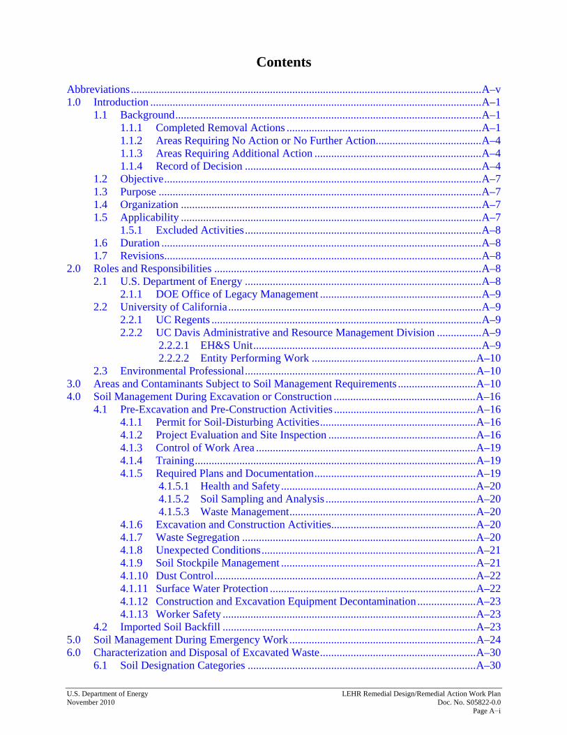
Contents Abbreviations .............................................................................................................................. A–v 1.0 Introduction ....................................................................................................................... A–1
1.1 Background .............................................................................................................. A–1 1.1.1 Completed Removal Actions ...................................................................... A–1 1.1.2 Areas Requiring No Action or No Further Action ...................................... A–4 1.1.3 Areas Requiring Additional Action ............................................................ A–4 1.1.4 Record of Decision ..................................................................................... A–4
1.2 Objective .................................................................................................................. A–7 1.3 Purpose .................................................................................................................... A–7 1.4 Organization ............................................................................................................ A–7 1.5 Applicability ............................................................................................................ A–7
1.5.1 Excluded Activities ..................................................................................... A–8 1.6 Duration ................................................................................................................... A–8 1.7 Revisions .................................................................................................................. A–8
2.0 Roles and Responsibilities ................................................................................................ A–8 2.1 U.S. Department of Energy ..................................................................................... A–8
2.1.1 DOE Office of Legacy Management .......................................................... A–9 2.2 University of California ........................................................................................... A–9
2.2.1 UC Regents ................................................................................................. A–9 2.2.2 UC Davis Administrative and Resource Management Division ................ A–9
2.2.2.1 EH&S Unit .................................................................................. A–9 2.2.2.2 Entity Performing Work ........................................................... A–10
2.3 Environmental Professional ................................................................................... A–10 3.0 Areas and Contaminants Subject to Soil Management Requirements ............................ A–10 4.0 Soil Management During Excavation or Construction ................................................... A–16
4.1 Pre-Excavation and Pre-Construction Activities ................................................... A–16 4.1.1 Permit for Soil-Disturbing Activities ........................................................ A–16 4.1.2 Project Evaluation and Site Inspection ..................................................... A–16 4.1.3 Control of Work Area ............................................................................... A–19 4.1.4 Training ..................................................................................................... A–19 4.1.5 Required Plans and Documentation .......................................................... A–19
4.1.5.1 Health and Safety ...................................................................... A–20 4.1.5.2 Soil Sampling and Analysis ...................................................... A–20 4.1.5.3 Waste Management ................................................................... A–20
4.1.6 Excavation and Construction Activities.................................................... A–20 4.1.7 Waste Segregation .................................................................................... A–20 4.1.8 Unexpected Conditions ............................................................................. A–21 4.1.9 Soil Stockpile Management ...................................................................... A–21 4.1.10 Dust Control .............................................................................................. A–22 4.1.11 Surface Water Protection .......................................................................... A–22 4.1.12 Construction and Excavation Equipment Decontamination ..................... A–23 4.1.13 Worker Safety ........................................................................................... A–23
4.2 Imported Soil Backfill ........................................................................................... A–23 5.0 Soil Management During Emergency Work ................................................................... A–24 6.0 Characterization and Disposal of Excavated Waste ........................................................ A–30
6.1 Soil Designation Categories .................................................................................. A–30

LEHR Remedial Design/Remedial Action Work Plan U.S. Department of Energy Doc. No. S05822-0.0 November 2010 Page A−ii
6.2 Soil Characterization ............................................................................................. A–30 6.2.1 Soil Sample Collection ............................................................................. A–30 6.2.2 Soil Sample Analysis ................................................................................ A–31
6.2.2.1 Data Quality Assessment .......................................................... A–32 6.2.3 Excavated Soil Designation ...................................................................... A–36
6.3 Waste Disposal ...................................................................................................... A–38 6.3.1 Clean Soil .................................................................................................. A–38 6.3.2 Nonhazardous Soil .................................................................................... A–38 6.3.3 Hazardous, Radioactive, or Mixed Waste Soil ......................................... A–39
7.0 Inspections ....................................................................................................................... A–40 8.0 Documentation ................................................................................................................ A–40
8.1 Recordkeeping ....................................................................................................... A–40 8.2 Soil Disturbance Reports ....................................................................................... A–40 8.3 Annual Reports ...................................................................................................... A–41 8.4 Audits ..................................................................................................................... A–41 8.5 5-Year Reviews ..................................................................................................... A–41
9.0 References ....................................................................................................................... A–42
Figures Figure A–1. Location of the LEHR Site, UC Davis, Solano County, California ...................... A–2 Figure A–2. LEHR Site Features ............................................................................................... A–3 Figure A–3. DOE Areas at LEHR Subject to Land-Use Controls, Including
Soil Management .................................................................................................. A–5 Figure A–4. Process for Conducting Non-emergency Work at the DOE Areas of the
Laboratory for Energy-Related Health Research ................................................ A–17 Figure A–5. Process for Conducting Emergency Work at the DOE Areas of the Laboratory
for Energy-Related Health Research .................................................................. A–25 Figure A–6. Decision Process for Disposal of Excavated Soil ................................................ A–26
Tables Table A–1. Constituents Detected at DOE Areas at Concentrations Above
Site Background ................................................................................................... A–12 Table A–2. Laboratory Analysis Parameters, Analytical Methods, Containers, Holding
Times, and Required Detection Limits for Soil/Solid Waste Samples ................ A–27 Table A–3. Required Detection Limits for Organic Constituents ........................................... A–35 Table A–4. Background Values for Metals and Radionuclides Potentially Present in Soil at
DOE Areas ........................................................................................................... A–37

U.S. Department of Energy LEHR Remedial Design/Remedial Action Work Plan November 2010 Doc. No. S05822-0.0 Page A−iii
Attachments Attachment A Tables of Contaminants Detected at Concentrations Above Site Background
(0−10 Feet Below Ground Surface) Attachment B Soil Sample Location Figures Attachment C Analytical Results, Soil Samples Collected in DOE Areas (on CD-ROM) Attachment D Soil Disturbance Permit

LEHR Remedial Design/Remedial Action Work Plan U.S. Department of Energy Doc. No. S05822-0.0 November 2010 Page A−iv
This page intentionally left blank

U.S. Department of Energy LEHR Remedial Design/Remedial Action Work Plan November 2010 Doc. No. S05822-0.0 Page A−v
Abbreviations CERCLA Comprehensive Environmental Response, Compensation, and Liability Act
CRWQCB California Regional Water Quality Control Board
DOE U.S. Department of Energy
DSS Domestic Septic System
DTSC California Department of Toxic Substances Control
EDPs Eastern Dog Pens
EH&S Environmental Health and Safety
EPA U.S. Environmental Protection Agency
ID identification
LEHR Laboratory for Energy-Related Health Research
LTS&M long-term surveillance and maintenance
MDL method detection limit
MOA Memorandum of Agreement
PCBs polychlorinated biphenyls
Ra/Sr Radium/Strontium
RD/RAWP Remedial Design/Remedial Action Work Plan
ROD Record of Decision
SMP Soil Management Plan
SWT Southwest Trenches
UC University of California
UC Davis University of California, Davis
WDPs Western Dog Pens
Weiss Weiss Associates

LEHR Remedial Design/Remedial Action Work Plan U.S. Department of Energy Doc. No. S05822-0.0 November 2010 Page A−vi
This page intentionally left blank

U.S. Department of Energy LEHR Remedial Design/Remedial Action Work Plan November 2010 Doc. No. S05822-0.0 Page A−1
1.0 Introduction This Soil Management Plan (SMP) provides information on, and direction for managing, minor residual contamination in soil that may be disturbed during work at the U.S. Department of Energy (DOE) areas of the former Laboratory for Energy-Related Health Research (LEHR) Federal Facility. This plan is a component of the Remedial Design/Remedial Action Work Plan (RD/RAWP), which provides requirements for implementing land-use restrictions per the Record of Decision (ROD) for the DOE Areas at LEHR (DOE 2009a) issued under the Comprehensive Environmental Response, Compensation, and Liability Act (CERCLA) of 1980. Certain activities that only disturb shallow soil (<1 foot deep) and generate de minimis amounts of soil (5 cubic yards or less) and that do not require off-site disposal are not subject to the requirements of this plan. 1.1 Background From 1958 to 1988, DOE operated the LEHR Federal Facility at the south campus of the University of California, Davis (UC Davis) (Figure A–1 and Figure A–2). Research at LEHR focused on the long-term health effects of low-level radiation on laboratory animals. The disposal of chemical and radioactive laboratory and campus waste contaminated soil and groundwater at LEHR. In May 1994, the U.S. Environmental Protection Agency (EPA) added the site to the National Priorities List. The responsibilities for the cleanup of the site were divided between DOE and UC Davis: DOE is responsible for remediating soil contamination in the DOE areas shown in Figure A–2 and any associated groundwater contamination, and UC Davis is responsible for cleaning up six landfill units and any associated groundwater contamination. UC Davis is developing remedial alternatives for their areas. If land-use restrictions, including soil management requirements, are adopted for UC Davis areas, this SMP may be amended to incorporate them. DOE has successfully completed decontamination, decommissioning, and removal actions at the DOE areas of the LEHR Federal Facility, and has thereby significantly reduced impacts of the chemical and radioactive contamination on human health and the environment to levels acceptable under CERCLA for current and anticipated land uses. Residual contaminants remain at the site at concentrations that prevent its unrestricted use (residential use) in the Domestic Septic System (DSS) 4 area, or that could contaminate groundwater above acceptable background levels. 1.1.1 Completed Removal Actions In 1995, DOE demolished the Imhoff Wastewater Treatment Facility (Figure A–2) as a voluntary removal action, and by 1997, DOE had completed the decontamination and decommissioning of the building (62 FR 51844–51845). DOE was responsible for the remediation of the Radium/Strontium (Ra/Sr) Treatment Systems; a waste burial area known as the DOE Disposal Box; on-site domestic septic tanks, associated leach fields, and dry wells; DOE disposal trenches; and the former Dog Pens (EPA 1999). By 2009, DOE had completed removal actions that addressed the principal threats at the DOE Disposal Box area, the Southwest Trenches (SWT) area, the Ra/Sr Treatment Systems area (which included DSS 2, parts of DSS 1, and parts of the DSS 5 leach field [including Dry Wells A–E]), the Western Dog Pens (WDPs), and the DSS 3 and 6 areas (Figure A–2).

LEHR Remedial Design/Remedial Action Work Plan U.S. Department of Energy Doc. No. S05822-0.0 November 2010 Page A−2
80
5
5
SacramentoUC Davis
SITE
0 2,000 feet
USGS 7.5' SeriesMerritt & Davis
CA Quadrangles
N
L:\LEHR\4114\146\LEHR_SiteLocationMap.ai
Figure A–1. Location of the LEHR Site, UC Davis, Solano County, California

U.S. D
epartment of Energy
LEH
R R
emedial D
esign/Rem
edial Action W
ork Plan N
ovember 2010
D
oc. No. S05822-0.0
Page A−3
South Fork Putah Creek
Land DisposalUnit 2
Eastern DisposalTrenches
Land DisposalUnit 1
WesternDog Pens
Eastern Dog Pens
DOE Disposal Box
DSS-1
DSS-5
DSS-7DSS-4
DSS-3
DSS-2
DSS-6
Old
DavisR
oad
Eastern DogPens
49 WasteBurial Holes
Southern Trenches
ToU
CD
avisMain
Cam
pusA
pproximately
1.8m
iles
Former LEHR Facility Boundary
LEHR/Old Campus Landfill Superfund SiteBoundary
DOE Area of Responsibility RequiringNo Further Action
DOE Area of Responsibility RequiringAdditional Action
UC Davis Area of Responsibility
Completed Removal Action
Domestic Septic System
Clinical Pathology Lab Building (H-215)
Specimen Storage Building (H-216)
Inter-Regional Project No. 4 Building (H-217)
Animal Hospital No. 2 Building (H-218)
Former Imhoff Waste Water Treatment Facility
EXPLANATION
8 11 12
15
9
13
17
1614
Cobalt-60Irradiation Field
7
6
4
5
1
3
2
10
Animal Hospital No. 1 Building (H-219)
Main Building (H-213)
Maintenance Shop Building (H-212)
Occupational and Environmental MedicineBuilding (H-289)
Cellular Biology Laboratory Building (H-294)
Storage Space Building (H-300)
Small Animal Housing Building (H-296)
Geriatrics Building No. 1 Building (H-292)
Geriatrics Building No. 2 Building (H-293)
Toxic Pollutant Health Research LaboratoryBuilding (H-299)
Cobalt-60 Annex Building (H-290)
Cobalt-60 Building (H-229)
1
2
3
4
5
6
7
8
9
10
11
12
13
14
15
16
17
DomesticSeptic System 4
Radium/StrontiumTreatment Systems
Dry WellsA through E
Southwest Trenches
DomesticSeptic System 3
Land DisposalUnit 3
0 150 ft
N
Approximate scale
L:\LEHR\4114\146\LEHR_SiteFeatures.ai
Figure A–2. LEHR Site Features

LEHR Remedial Design/Remedial Action Work Plan U.S. Department of Energy Doc. No. S05822-0.0 November 2010 Page A−4
1.1.2 Areas Requiring No Action or No Further Action DOE released all of the LEHR buildings to UC Davis for unrestricted use and accelerated site cleanup by completing several removal actions that addressed the principal environmental threats at the LEHR Federal Facility. Based on DOE’s compliance with DOE Order 5400.5, Radioactive Protection of the Public and the Environment, for the release of property for unrestricted use (62 FR 51844–51845), no action or no further action is required at all LEHR buildings (including the Imhoff Wastewater Treatment Facility demolished in 1995). In addition to no action being necessary at the LEHR buildings, based on the Site-Wide Risk Assessment, Volume I: Human Health Risk Assessment (Part B Risk Characterization for DOE Areas) (Weiss 2005), no further action is required at the following areas of the LEHR Federal Facility:
• DSS areas other than DSSs 3 and 4,
• The DOE Disposal Box, and
• The WDPs area (Figure A–2). Similarly, no action is required at the Cobalt-60 Irradiation Field because the area has no identified contamination, and there is no potential for contamination based on historical use. Figure A–2 shows all of these areas and their designations. 1.1.3 Areas Requiring Additional Action The following areas of the LEHR Federal Facility contain residual contaminants that present potential excess cancer risks above 1 in 1 million, or have the potential to impact groundwater quality:
• The Ra/Sr Treatment Systems area;
• DSS 3;
• DSS 4;
• Dry Wells A–E;
• The SWT area; and
• The Eastern Dog Pens (EDPs) area (Figure A–3). 1.1.4 Record of Decision In 2009, DOE and EPA approved a ROD for the DOE areas at LEHR (DOE 2009a) in accordance with CERCLA. The ROD documents the selection of the following remedies for the DOE areas:
• Long-term groundwater monitoring with contingent remediation and an SMP at the Ra/Sr Treatment Systems area, DSS 3, Dry Wells A−E, and the SWT area.
• Long-term groundwater monitoring with contingent remediation, a land-use restriction prohibiting residential use, and an SMP at DSS 4.

U.S. Department of Energy LEHR Remedial Design/Remedial Action Work Plan November 2010 Doc. No. S05822-0.0 Page A−5
Figure A–3. DOE Areas at LEHR Subject to Land-Use Controls, Including Soil Management

LEHR Remedial Design/Remedial Action Work Plan U.S. Department of Energy Doc. No. S05822-0.0 November 2010 Page A−6
This page intentionally left blank

U.S. Department of Energy LEHR Remedial Design/Remedial Action Work Plan November 2010 Doc. No. S05822-0.0 Page A−7
• The implementation of an SMP at the EDPs area.
• No further action at the DSS 1, DSS 5, DSS 6, DSS 7, WDPs, and DOE Disposal Box areas. The land-use control components of the selected remedy are described in the RD/RAWP, and include the development and implementation of this SMP (which is an appendix to the RD/RAWP) to specify controls that would apply to activities that disturb the subsurface. The general requirements of the RD/RAWP and this SMP shall be documented in recorded land-use covenants. 1.2 Objective The objective of this SMP is to establish policy and requirements for the management and disposal of soils generated during construction, maintenance, and other activities that might disturb contaminated soil at the DOE areas at LEHR. 1.3 Purpose This SMP describes specific soil-handling controls required for compliance with the ROD (DOE 2009a). As stated in the ROD, the purpose of the SMP is to:
• Prevent unacceptable exposure to contaminated soil, and
• Prevent the improper disposal of contaminated soils. 1.4 Organization This SMP contains:
• Background information about the DOE areas of the LEHR Federal Facility;
• The roles and responsibilities of DOE, UC Davis, and the regulatory agencies in implementing this SMP;
• Information on the nature and extent of soil contaminants at the DOE areas at LEHR;
• Requirements for the management of contaminated soils that might be disturbed during construction, maintenance, or other activities;
• Requirements for the disposal of waste soils generated during construction, maintenance, or other activities;
• Requirements for emergency work that might disturb contaminated soil;
• Inspection requirements; and
• Recordkeeping and reporting requirements. 1.5 Applicability This SMP applies to soil-disturbing activities performed at the DOE areas at LEHR identified in Figure A–3 as subject to the SMP. Soil-disturbing activities include excavation, grading, trenching, utility installation or repair, and any other human activities that could potentially bring
LEHR Remedial Design/Remedial Action Work Plan U.S. Department of Energy Doc. No. S05822-0.0 November 2010 Page A−8
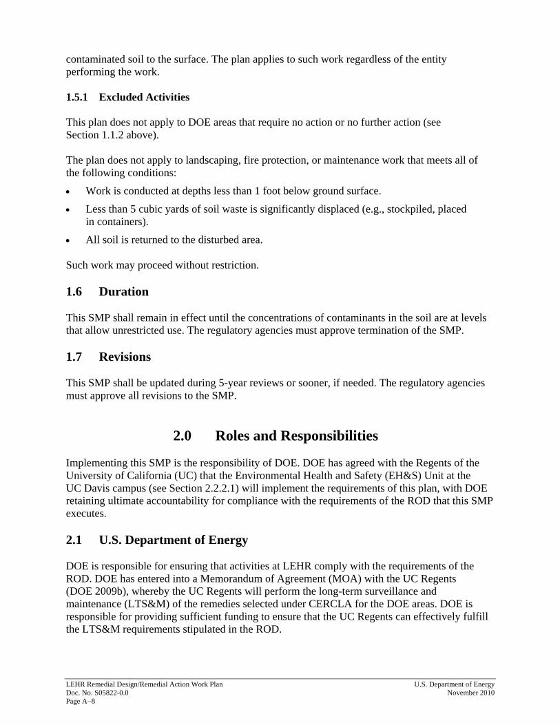
contaminated soil to the surface. The plan applies to such work regardless of the entity performing the work. 1.5.1 Excluded Activities This plan does not apply to DOE areas that require no action or no further action (see Section 1.1.2 above). The plan does not apply to landscaping, fire protection, or maintenance work that meets all of the following conditions:
• Work is conducted at depths less than 1 foot below ground surface.
• Less than 5 cubic yards of soil waste is significantly displaced (e.g., stockpiled, placed in containers).
• All soil is returned to the disturbed area. Such work may proceed without restriction. 1.6 Duration This SMP shall remain in effect until the concentrations of contaminants in the soil are at levels that allow unrestricted use. The regulatory agencies must approve termination of the SMP. 1.7 Revisions This SMP shall be updated during 5-year reviews or sooner, if needed. The regulatory agencies must approve all revisions to the SMP.
2.0 Roles and Responsibilities Implementing this SMP is the responsibility of DOE. DOE has agreed with the Regents of the University of California (UC) that the Environmental Health and Safety (EH&S) Unit at the UC Davis campus (see Section 2.2.2.1) will implement the requirements of this plan, with DOE retaining ultimate accountability for compliance with the requirements of the ROD that this SMP executes. 2.1 U.S. Department of Energy DOE is responsible for ensuring that activities at LEHR comply with the requirements of the ROD. DOE has entered into a Memorandum of Agreement (MOA) with the UC Regents (DOE 2009b), whereby the UC Regents will perform the long-term surveillance and maintenance (LTS&M) of the remedies selected under CERCLA for the DOE areas. DOE is responsible for providing sufficient funding to ensure that the UC Regents can effectively fulfill the LTS&M requirements stipulated in the ROD.

U.S. Department of Energy LEHR Remedial Design/Remedial Action Work Plan November 2010 Doc. No. S05822-0.0 Page A−9
2.1.1 DOE Office of Legacy Management The DOE Office of Legacy Management ensures that DOE’s long-term cleanup obligations are met. The Office of Legacy Management identifies actions and plans, such as this SMP, that are necessary to maintain the protection of a remedy. These actions are documented in an LTS&M Plan (DOE 2005) that states how the requirements of the ROD and remedial implementation work plans, and 5-year review findings shall be met. The LEHR LTS&M Plan defines the requirements for managing and containing soil at the site. As part of the implementation of the LTS&M Plan, the Office of Legacy Management is responsible for annually reporting to the California Department of Toxic Substances Control (DTSC) and all other signatories to the ROD the status of land-use controls and for conducting 5-year reviews as required by the ROD. 2.2 University of California 2.2.1 UC Regents The UC Regents have entered into an MOA (DOE 2009b), whereby the UC Regents are responsible for:
• Recording the land-use covenant with DTSC.
• Developing and maintaining internal policies and procedures to ensure that land-use restrictions (such as this SMP) are maintained.
• Visiting sites to ensure that land-use restrictions (such as this SMP) are maintained.
• Developing and providing annual training for campus stakeholders affected by the restrictions (such as this SMP).
2.2.2 UC Davis Administrative and Resource Management Division The UC Davis Administrative and Resource Management Division provides facilities, land management, and safety services on the UC Davis campus. 2.2.2.1 EH&S Unit The EH&S Unit within the Administrative and Resource Management Division reviews and approves projects conducted by the Design and Construction Management, Facilities Management, Campus Planning, Community Resources, and other units. The review by EH&S focuses on compliance with safety regulations. For the purpose of this SMP, the EH&S Unit is responsible for communicating the nature and scope of institutional controls applicable to the DOE areas at the LEHR Site to the other units performing or contracting work, and for ensuring that the institutional controls are implemented.

LEHR Remedial Design/Remedial Action Work Plan U.S. Department of Energy Doc. No. S05822-0.0 November 2010 Page A−10
The EH&S Unit shall maintain and make available to interested parties copies of this SMP and the RD/RAWP. The EH&S Unit shall develop and maintain internal policies and procedures to ensure that:
• This SMP and other land-use restrictions are implemented;
• The DOE areas are visited to verify that all land-use restrictions are maintained; and
• Campus stakeholders affected by the restrictions receive annual training. The EH&S Unit shall review and, upon concurrence from a qualified environmental professional (see Section 2.3), approve all requests for subsurface disturbance at the LEHR Site, and ensure that the appropriate controls are in place before and during soil-disturbing activities. The EH&S Unit shall maintain records of all activities conducted in the DOE areas and shall provide DOE with these records upon request, or as required by this SMP, the RD/RAWP, the ROD, or the MOA between DOE and the UC Regents. 2.2.2.2 Entity Performing Work The entity that performs work in any DOE area subject to this SMP is responsible for submitting a permit application to the EH&S Unit, a successor unit or organization, or a unit to which EH&S has delegated its responsibilities under the MOA and this SMP, for review and approval before any soil-disturbing activities begin. The entity must also develop all required plans and procedures, and secure appropriate regulatory permits. The entity performing work must conduct all work in conformance with the requirements of this SMP and any requirements imposed by the EH&S Unit or regulatory agencies, and must provide the EH&S Unit with documentation required by this SMP, the Soil Disturbance Permit, and regulatory drivers. 2.3 Environmental Professional An environmental professional will oversee all soil disturbance activities in the DOE areas subject to this SMP. The environmental professional must be qualified by education, training, or experience—or some combination—to review proposed work in areas subject to this SMP for potential risks; risk controls; waste disposal requirements; and compliance with all applicable laws, regulations, and industry standards, as applicable. For any work proposed for the DOE areas subject to this SMP, the environmental professional shall be responsible for reviewing permits, plans, and documents; advising the EH&S Unit or DOE on the appropriate methods or controls for the work; and overseeing the implementation of all controls required for the work. An environmental professional may be an employee of the University of California or a subcontractor to the University of California or DOE.
3.0 Areas and Contaminants Subject to Soil Management Requirements
This SMP applies to areas where potential contaminants remain in soil (Figure A–3). As discussed in Section 1.1.1, DOE removed all waste from the DOE areas at LEHR. Small quantities of several contaminants remain in the soil. lists constituents that may be present in site

U.S. Department of Energy LEHR Remedial Design/Remedial Action Work Plan November 2010 Doc. No. S05822-0.0 Page A−11
soils from 0 to 10 feet below ground surface. All contaminants present in soil above background concentrations should be considered when soil is evaluated for on-site reuse or off-site disposal. Site risks from the residual contamination were quantified and characterized in the site-wide risk assessments (UC Davis 2004, UC Davis 2006, Weiss 2005) that addressed human health, ecological receptors, and groundwater resources. The risk assessments showed that contaminants can remain in DOE areas’ soil at concentrations above site background without posing a significant risk, depending on the contaminant’s toxicity, mobility, and relative background concentration. EPA requires that contaminants that may pose an estimated excess cancer risk greater than 1 in 1 million be evaluated further and, possibly, cleaned up. The risk assessments showed that most of the contaminants remaining in soil did not pose such a risk. Risk to the hypothetical on-site resident was below this threshold at DSS 3, Dry Wells A–E, and the Ra/Sr Treatment Systems area. The risk assessments also indicated that the potential risk to on-site construction workers was less than 1 in 1 million at DSS 3; Dry Wells A–E; and the Ra/Sr Treatment Systems, SWT, and EDPs areas. The risk calculations were based on conservative assumptions. Risk to a hypothetical on-site resident was based on exposure to soil through direct dermal contact, ingestion, inhalation of soil particulates, ingestion of home-grown produce and external radiation from radionuclides in soil. The exposure duration for residents was assumed to extend over 30 years, including 6 years as a child and 24 years as an adult and to occur 350 days per year. Risk to a construction worker was based on exposure to soil through direct dermal contact, ingestion, inhalation of soil particulates and external radiation. The construction worker was assumed to be exposed on 250 days for the duration of 1 year. The estimated human health risk to a hypothetical on-site resident was above 1 in 1 million for some contaminants at the DSS 4, EDPs, and SWT areas. The highest risk to the hypothetical on-site resident was 4 in 10,000 from benzo(k)fluoranthene at DSS 4, primarily due to ingesting homegrown produce. The ingestion of strontium-90 in homegrown produce also poses slight risks at the SWT area (3 in 1 million) and EDPs area (1 in 1 million). On-site construction workers were estimated to have a 1-in-1-million risk from benzo(a)pyrene in subsurface soil at DSS 4. In Table A–1, constituents of concern, due to potential human health risks, are noted with an “HH.” The risk managers decided to address potential risks associated with these constituents through land-use restrictions, including this SMP. The human health risks did not necessitate the implementation of cleanup technology. The risk assessments indicated that residual contamination in DOE areas presents no significant risks to ecological receptors; consequently, no ecological risk management actions are being taken at the DOE areas. Some contaminants at the DSS 3 and 4, Dry Wells A–E, Ra/Sr Treatment Systems, and SWT areas were found to pose potential risk to groundwater if they were to migrate from site soils to groundwater. DOE is required to monitor groundwater at the site for these constituents (noted with a “GW” in Table A–1) and evaluate the need for remedial action should these contaminants impact groundwater beneath the site. The wells that will be used for this groundwater monitoring are shown on Figure A–3.

LEHR Remedial Design/Remedial Action Work Plan U.S. Department of Energy Doc. No. S05822-0.0 November 2010 Page A−12
Table A–1. Constituents Detected at DOE Areas at Concentrations Above Site Background
Area Above-Background Constituent Statistical Basisa
Domestic Septic System 3
Cesium-137 Max >UTL Lead-210 Max >UTL Strontium-90 Max >UTL Thallium Max >UTL Zinc Mann-Whitney (WRS Test) 1,3-Dichlorobenzene >5 percent detection 1,4-Dichlorobenzene >5 percent detection 2-Butanone >5 percent detection 2-Methylnaphthalene >5 percent detection Acetone >5 percent detection alpha-Chlordane >5 percent detection Aroclor-1254 >5 percent detection Benzaldehyde >5 percent detection Bis(2-ethylhexyl)phthalateb >5 percent detection Butylbenzylphthalate >5 percent detection Di-n-butylphthalate >5 percent detection Di-n-octylphthalate >5 percent detection Dieldrin >5 percent detection Diethylphthalate >5 percent detection Endrin aldehyde >5 percent detection Formaldehyde GW >5 percent detection gamma-Chlordane >5 percent detection Hexachlorobenzene >5 percent detection Isopropylbenzene >5 percent detection Methyl acetate >5 percent detection Pyrene >5 percent detection Styrene >5 percent detection Toluene >5 percent detection Trichlorofluoromethane >5 percent detection
Domestic Septic System 4
Chromium Mann-Whitney (WRS Test) Lead-210 Max >UTL Selenium Max >UTL Strontium-90 Max >UTL Uranium-235 Max >UTL 1,4-Dichlorobenzene >5 percent detection 2-Methylnaphthalene >5 percent detection 4,4’-DDE >5 percent detection Acenaphthene >5 percent detection Acetoneb >5 percent detection alpha-Chlordane >5 percent detection Anthracene >5 percent detection Benzo(a)anthracene HH >5 percent detection Benzo(a)pyrene HH >5 percent detection Benzo(b)fluoranthene HH >5 percent detection Benzo(g,h,i)perylene >5 percent detection

Table A–1 (continued). Constituents Detected at DOE Areas at Concentrations Above Site Background
U.S. Department of Energy LEHR Remedial Design/Remedial Action Work Plan November 2010 Doc. No. S05822-0.0 Page A−13
Area Above-Background Constituent Statistical Basisa
Domestic Septic System 4 (continued)
Benzo(k)fluoranthene HH >5 percent detection Bis(2-ethylhexyl)phthalateb >5 percent detection Butylbenzylphthalate >5 percent detection Carbazole >5 percent detection Chlordane >5 percent detection Chrysene >5 percent detection Dibenzo(a,h)anthracene HH >5 percent detection Dibenzofuran >5 percent detection Ethylbenzene >5 percent detection Fluoranthene >5 percent detection Fluorene >5 percent detection gamma-Chlordane >5 percent detection Heptachlor >5 percent detection Heptachlor epoxide >5 percent detection Indeno(1,2,3-cd)pyrene HH >5 percent detection Methylene chlorideb >5 percent detection Naphthalene >5 percent detection Phenanthrene >5 percent detection Phenol >5 percent detection Pyrene >5 percent detection Styrene >5 percent detection Toluene >5 percent detection Xylenes >5 percent detection
Dry Wells A–E
Arsenic Mann-Whitney (WRS Test) Barium Mann-Whitney (WRS Test) Beryllium Mann-Whitney (WRS Test) Carbon-14 Max >UTL Cobalt-60 Max >UTL Copper Mann-Whitney (WRS Test) Iron Mann-Whitney (WRS Test) Radium-226 Mann-Whitney (WRS Test) Selenium Max >UTL Silver Max >UTL Strontium-90 GW Max >UTL Thorium-228 Mann-Whitney (WRS Test) Thorium-232 Mann-Whitney (WRS Test) Thorium-234 Mann-Whitney (WRS Test) Uranium-233/234 Mann-Whitney (WRS Test) Uranium-238 Mann-Whitney (WRS Test) Vanadium Mann-Whitney (WRS Test) Zinc Mann-Whitney (WRS Test) 2-Butanone >5 percent detection alpha-Chlordane >5 percent detection Ethylbenzene >5 percent detection gamma-Chlordane >5 percent detection Toluene >5 percent detection
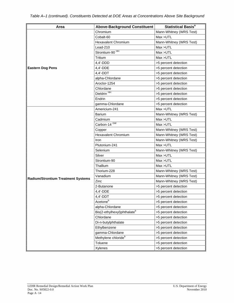
Table A–1 (continued). Constituents Detected at DOE Areas at Concentrations Above Site Background
LEHR Remedial Design/Remedial Action Work Plan U.S. Department of Energy Doc. No. S05822-0.0 November 2010 Page A−14
Area Above-Background Constituent Statistical Basisa
Eastern Dog Pens
Chromium Mann-Whitney (WRS Test) Cobalt-60 Max >UTL Hexavalent Chromium Mann-Whitney (WRS Test) Lead-210 Max >UTL Strontium-90 HH Max >UTL Tritium Max >UTL 4,4’-DDD >5 percent detection 4,4’-DDE >5 percent detection 4,4’-DDT >5 percent detection alpha-Chlordane >5 percent detection Aroclor-1254 >5 percent detection Chlordane >5 percent detection Dieldrin HH >5 percent detection Endrin >5 percent detection gamma-Chlordane >5 percent detection
Radium/Strontium Treatment Systems
Americium-241 Max >UTL Barium Mann-Whitney (WRS Test) Cadmium Max >UTL Carbon-14 GW Max >UTL Copper Mann-Whitney (WRS Test) Hexavalent Chromium Mann-Whitney (WRS Test) Iron Mann-Whitney (WRS Test) Plutonium-241 Max >UTL Selenium Mann-Whitney (WRS Test) Silver Max >UTL Strontium-90 Max >UTL Thallium Max >UTL Thorium-228 Mann-Whitney (WRS Test) Vanadium Mann-Whitney (WRS Test) Zinc Mann-Whitney (WRS Test) 2-Butanone >5 percent detection 4,4’-DDE >5 percent detection 4,4’-DDT >5 percent detection Acetoneb >5 percent detection alpha-Chlordane >5 percent detection Bis(2-ethylhexyl)phthalateb >5 percent detection Chlordane >5 percent detection Di-n-butylphthalate >5 percent detection Ethylbenzene >5 percent detection gamma-Chlordane >5 percent detection Methylene chlorideb >5 percent detection Toluene >5 percent detection Xylenes >5 percent detection

Table A–1 (continued). Constituents Detected at DOE Areas at Concentrations Above Site Background
U.S. Department of Energy LEHR Remedial Design/Remedial Action Work Plan November 2010 Doc. No. S05822-0.0 Page A−15
Area Above-Background Constituent Statistical Basisa
Southwest Trenches
Americium-241 Max >UTL Antimony Max >UTL Barium Mann-Whitney (WRS Test) Carbon-14 GW Max >UTL Cesium-137 Max >UTL Cobalt-60 Max >UTL Hexavalent Chromium Mann-Whitney (WRS Test) Iron Mann-Whitney (WRS Test) Lead-210 Max >UTL Plutonium-241 Max >UTL Selenium Max >UTL Silver Max >UTL Strontium-90 HH Max >UTL Thorium-228 Mann-Whitney (WRS Test) Tritium Max >UTL Vanadium Mann-Whitney (WRS Test) Zinc Mann-Whitney (WRS Test) 2-Butanone >5 percent detection 4,4’-DDD >5 percent detection 4,4’-DDE >5 percent detection 4,4’-DDT >5 percent detection alpha-Chlordane >5 percent detection Dieldrin >5 percent detection Ethylbenzene >5 percent detection Formaldehyde >5 percent detection gamma-Chlordane >5 percent detection Heptachlor >5 percent detection Heptachlor epoxide >5 percent detection Toluene >5 percent detection Xylenes >5 percent detection
Notes: a Background test results for inorganic constituents in soil from 0 to 10 feet below ground surface. The organic constituent background level is 0. Organic constituents are assumed to exceed background if the frequency of detection was 5 percent or more. Inorganic constituent statistical test results and the organic constituent frequency of detection are taken from the Revised LEHR/SCDS Site-Wide Risk Assessment, Volume I: Human Health Risk Assessment (UC Davis 2004). b Common laboratory contaminant. Abbreviations: >5 percent Detection = Organic DDD = Dichlorodiphenyldichloroethane DDE = Dichlorodiphenyldichloroethylene DDT = Dichlorodiphenyltrichloroethane DSS = Domestic Septic System EDPs = Eastern Dog Pens GW = Constituent of concern with potential to impact groundwater quality (DOE 2009a) HH = Human health constituent of concern (DOE 2009a) Mann-Whitney (WRS Test) = Constituent is above background based on results of Mann-Whitney statistical test (also known as Wilcoxon Rank Sum test). Max >UTL = Maximum detected concentration is above the background upper tolerance limit (80 percent lower confidence limit on the 95th percentile). Ra/Sr = Radium/Strontium SWT = Southwest Trenches WRS = Wilcoxon Rank Sum

LEHR Remedial Design/Remedial Action Work Plan U.S. Department of Energy Doc. No. S05822-0.0 November 2010 Page A−16
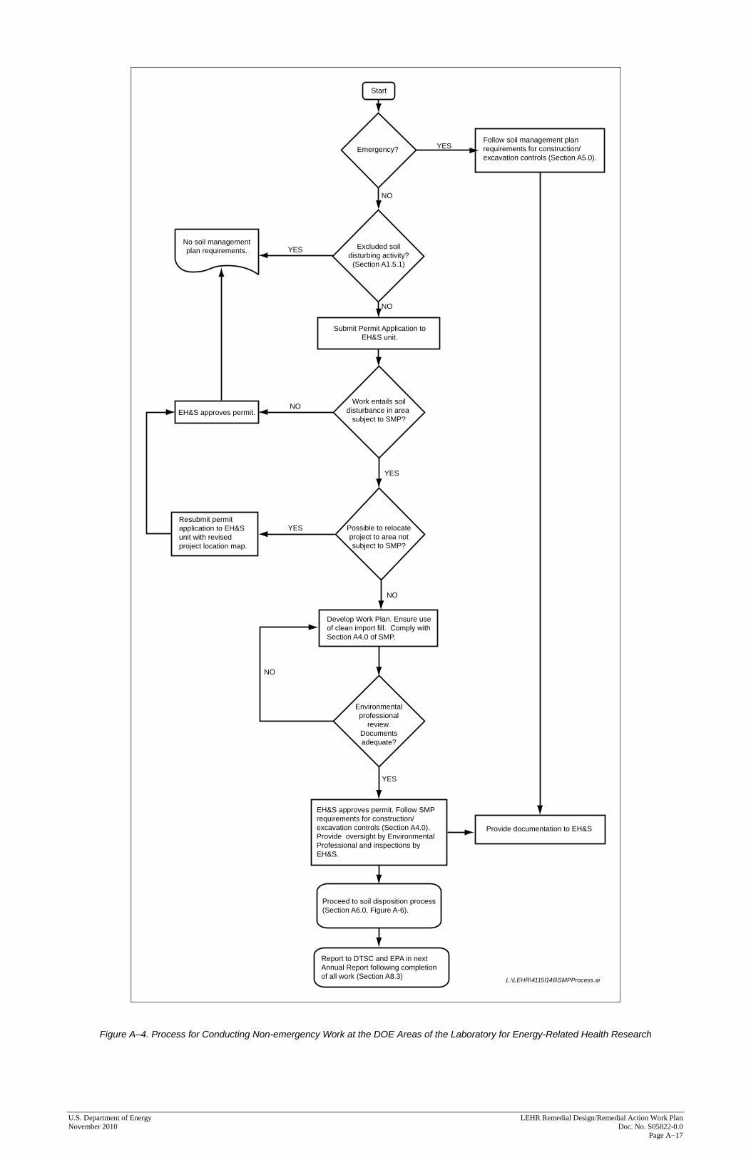
4.0 Soil Management During Excavation or Construction Soil with residual contamination may be encountered during maintenance, excavation, trenching, and other soil-disturbing activities at DOE areas at LEHR. All personnel, whether UC staff or contractors, conducting excavation, digging, or other soil-disturbing operations must be made aware that there is a potential for encountering contamination, and must know the procedures for dealing with contamination. All soil-disturbing activities at DOE areas subject to this SMP (except emergency activities) shall be conducted under the oversight of an environmental professional and shall follow the process illustrated in Figure A–4 and described below. Section 5.0 discusses emergency work. 4.1 Pre-Excavation and Pre-Construction Activities 4.1.1 Permit for Soil-Disturbing Activities Before any soil-disturbing activities are conducted at the DOE areas, the UC Davis EH&S Unit shall be notified of the nature and location of the work to be performed. A permit application (Attachment D)—detailing the nature of the project; the project’s location; and the expected depth of any proposed trenching, excavation, drilling, or other soil disturbance—shall be submitted to the EH&S Unit. No work may begin until the EH&S Unit approves the permit for the proposed project. The EH&S staff will review the proposed work locations to determine whether the work may occur in areas subject to this SMP. In conducting this review, survey maps for the DOE areas subject to land-use restrictions shall be used. If the proposed work may be conducted in areas subject to the SMP, the EH&S Unit will ensure that the UC Davis unit or contractor performing the work is aware of all of the requirements of this SMP and will work with the unit to ensure compliance. The EH&S Unit and the environmental professional will also assist the entity performing the work in determining whether any preconstruction soil sampling is required based on the intended disposition of the soil, available contaminant data, off-site disposal facility acceptance requirements, and other factors. As outlined in the Soil Disturbance Permit (Attachment D), soil disturbed at 0–10 feet below ground surface will be sampled for constituents in Table A–1 as appropriate based on location. Soil disturbed at >10 feet below ground surface will be sampled for constituents determined by professional judgment to be potentially present in the soil in concentrations above site background, based on the data presented in Attachment C. 4.1.2 Project Evaluation and Site Inspection An evaluation of the proposed project will be conducted by the EH&S Unit and an environmental professional, and will consist of a review of all available data, including survey maps and contaminant distribution data provided in this SMP (Section 3.0 and Attachments A and B) to determine the appropriate requirements regarding health and safety, storm water, and waste disposal. Because some of the residual contaminants are potentially subject to migration and degradation or decay, additional data and/or estimates of environmental fate and transport of residual contaminants will be considered by the EH&S Unit and environmental professional in the soil management planning process Information regarding residual contamination distribution
U.S. Department of Energy LEHR Remedial Design/Remedial Action Work Plan November 2010 Doc. No. S05822-0.0 Page A−17
YES
NO
NO
Emergency?
EH&S approves permit.
No soil managementplan requirements.
Submit Permit Application toEH&S unit.
Resubmit permitapplication to EH&Sunit with revisedproject location map.
EH&S approves permit. Follow SMPrequirements for construction/excavation controls (Section A4.0).Provide oversight by EnvironmentalProfessional and inspections byEH&S.
Provide documentation to EH&S
Follow soil management planrequirements for construction/excavation controls (Section A5.0).
Develop Work Plan. Ensure useof clean import fill. Comply withSection A4.0 of SMP.
Work entails soildisturbance in area
subject to SMP?
Excluded soildisturbing activity?
(Section A1.5.1)
Start
L:\LEHR\4115\146\SMPProcess.ai
Proceed to soil disposition process(Section A6.0, Figure A-6).
Report to DTSC and EPA in nextAnnual Report following completionof all work (Section A8.3)
YES
YES
NO
Possible to relocateproject to area notsubject to SMP?
Environmentalprofessional
review.Documentsadequate?
YES
NO
YES
NO
Figure A–4. Process for Conducting Non-emergency Work at the DOE Areas of the Laboratory for Energy-Related Health Research

LEHR Remedial Design/Remedial Action Work Plan U.S. Department of Energy Doc. No. S05822-0.0 November 2010 Page A–18
This page intentionally left blank
U.S. Department of Energy LEHR Remedial Design/Remedial Action Work Plan November 2010 Doc. No. S05822-0.0 Page A−19
and fate and transport is included in the Risk Characterization Report (Weiss 2005), which may be obtained from the EH&S Unit, DOE Office of Legacy Management, or EPA. Before any soil-disturbing activities are conducted at the DOE areas subject to this SMP, the EH&S Unit will—with the UC Davis unit or contractor performing the proposed work—inspect the site to physically identify areas of the proposed work that will be subject to the requirements of this SMP. If it is possible to move the proposed work to an area that is not subject to this SMP, or to an area with more-limited residual contamination, the EH&S Unit will recommend such a move, to avoid disturbing contaminated soils. 4.1.3 Control of Work Area Before any soil-disturbing activities are conducted at the DOE areas subject to this SMP, the UC Davis unit or contractor performing the work shall secure the work area to limit access to only those staff that are authorized and trained to work there. 4.1.4 Training All staff who will conduct soil-disturbing activities at the DOE areas subject to this SMP must receive appropriate training regarding the contaminants that might be present, the associated health hazards and hazard controls, soil-handling and waste-management requirements, and emergency procedures. As required by law and depending on their assignment, site workers shall be trained in hazardous waste operations and emergency response in accordance with the requirements of Title 29 Code of Federal Regulations Section 1910.120 and Section 5192 of Title 8 California Code of Regulations. Specific training requirements shall be included in work plans and Health and Safety Plans discussed below. UC Davis implements a Safety Management Program described in the UC Davis Policy and Procedure Manual, Chapter 290, Health and Safety Services, Section 151. The training related to soil-disturbing activities in the DOE areas subject to the SMP will be incorporated into this Safety Management Program. 4.1.5 Required Plans and Documentation Before soil-disturbing activities are conducted, a work plan that covers the following topics shall be developed and approved:
• Health and safety
• Soil moving and storage procedures, including equipment to be used
• Soil sampling and analysis
• Waste management The work plan should be tailored to the scope of the activity to be performed. Appropriate permits shall be obtained for the work to be performed.
1 The Policy and Procedure Manual can be found at http://manuals.ucdavis.edu/PPM/290/290-15.htm
LEHR Remedial Design/Remedial Action Work Plan U.S. Department of Energy Doc. No. S05822-0.0 November 2010 Page A–20
All plans for soil-disturbing activities must be reviewed by an environmental professional and approved by the EH&S Unit. 4.1.5.1 Health and Safety The health and safety element of the work plan should address potential exposure to site contaminants and provide requirements to control such exposure, including appropriate engineering and administrative controls and personal protective equipment. 4.1.5.2 Soil Sampling and Analysis The sampling and analysis element should be developed to ensure that samples are collected in conformance with EPA data-quality requirements, and meet the needs of the waste disposal facility in the case of off-site disposal. 4.1.5.3 Waste Management The waste management element should include procedures for segregating, characterizing, handling, storing, treating (if anticipated), and disposing of waste. Requirements for the proper disposal of investigation-derived waste and decontamination waste shall be included. The cost of disposing of low-level radioactive waste containing chemical contaminants can be significantly higher than the cost of disposing of soil with added radiological constituents, or soil containing only chemical contamination or no contamination. Soil with added radiological constituents should be segregated from soil containing only chemical contamination or no contamination. Soil determined to be hazardous shall be transported by a licensed hauler to a permitted hazardous waste disposal facility. Soil determined to be radioactive waste or mixed radioactive waste shall be transported to a disposal facility permitted to accept radioactive or mixed waste. 4.1.6 Excavation and Construction Activities Excavation and construction activities shall be performed in a manner that minimizes worker exposure and protects the environment from site contaminants. A designated work area boundary shall be established for excavation and construction activities. 4.1.7 Waste Segregation Waste areas shall be secured and posted. Soil from the top 1 foot below ground surface shall be segregated and returned to backfill the top of the excavation if soils will not be sampled. Soil with added radiological constituents should be segregated from soil containing only chemical contamination or no contamination. To facilitate preliminary waste segregation decisions in DOE soil management areas, Attachments A and B provide the existing soil analytical data. The data should be used to evaluate the types of contaminants that might be present and to plan excavation, soil-handling, stockpiling, and disposal activities. The evaluation and segregation approaches should be conducted or reviewed by the environmental professional.

U.S. Department of Energy LEHR Remedial Design/Remedial Action Work Plan November 2010 Doc. No. S05822-0.0 Page A−21
4.1.8 Unexpected Conditions Excavation, digging, or other soil-disturbing activities should immediately cease upon the discovery of potentially contaminated soil or other material in an area not previously identified as containing residual contaminants or contaminated features (e.g., underground sumps, underground tanks, underground drain lines suspected of containing contamination, laboratory waste). Evidence of potentially contaminated soil or other material includes, but is not limited to:
• Discolored soil;
• Odors;
• Readings on monitoring equipment (e.g., Photoionization Detector) indicating potential presence of contaminants;
• Laboratory glassware, chemical vials, bottles or other containers;
• Drums or carboys;
• Other laboratory equipment;
• Animal wastes or bones;
• Pipes or other debris that appear to be part of an underground waste management system, such as a sump, underground tank, leach field, and so on.
The EH&S Unit must be immediately notified of the discovery. If an excavation, digging, or other soil-disturbing activity results in an encounter with unexpected contamination identified as a CERCLA hazardous substance, notice will be promptly provided to DOE, EPA Region 9, DTSC, the California Regional Water Quality Control Board, and the California Department of Public Health so that a determination can be made regarding the need for a CERCLA response or further investigation. 4.1.9 Soil Stockpile Management Soil stockpiles, if used, shall be placed on top of heavy-duty plastic sheeting. Wherever possible, excavated soil will be stockpiled on areas with improved asphalt or concrete surface. Potentially hazardous or radioactive waste will be stored in a designated area. Unauthorized access to such areas will be prevented by fencing or other means. Soil stockpiles shall be covered with material adequate to prevent soil transport by wind or rainwater runoff. Covers shall be maintained in good condition. When not covered, soil stockpile surfaces will be kept visibly moist by water spray, as necessary.
LEHR Remedial Design/Remedial Action Work Plan U.S. Department of Energy Doc. No. S05822-0.0 November 2010 Page A–22
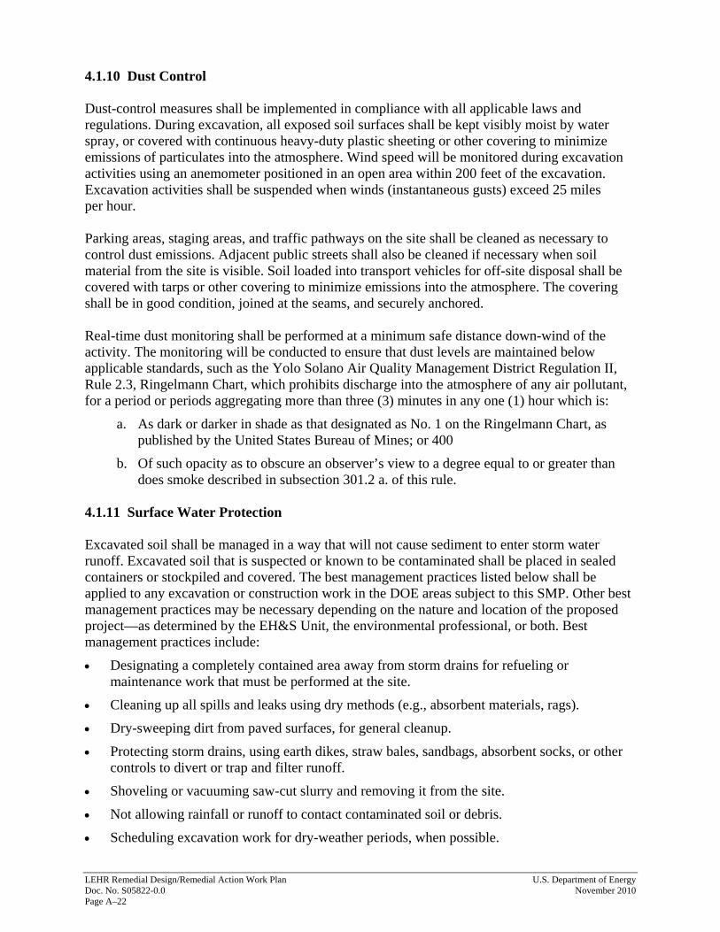
4.1.10 Dust Control Dust-control measures shall be implemented in compliance with all applicable laws and regulations. During excavation, all exposed soil surfaces shall be kept visibly moist by water spray, or covered with continuous heavy-duty plastic sheeting or other covering to minimize emissions of particulates into the atmosphere. Wind speed will be monitored during excavation activities using an anemometer positioned in an open area within 200 feet of the excavation. Excavation activities shall be suspended when winds (instantaneous gusts) exceed 25 miles per hour. Parking areas, staging areas, and traffic pathways on the site shall be cleaned as necessary to control dust emissions. Adjacent public streets shall also be cleaned if necessary when soil material from the site is visible. Soil loaded into transport vehicles for off-site disposal shall be covered with tarps or other covering to minimize emissions into the atmosphere. The covering shall be in good condition, joined at the seams, and securely anchored. Real-time dust monitoring shall be performed at a minimum safe distance down-wind of the activity. The monitoring will be conducted to ensure that dust levels are maintained below applicable standards, such as the Yolo Solano Air Quality Management District Regulation II, Rule 2.3, Ringelmann Chart, which prohibits discharge into the atmosphere of any air pollutant, for a period or periods aggregating more than three (3) minutes in any one (1) hour which is:
a. As dark or darker in shade as that designated as No. 1 on the Ringelmann Chart, as published by the United States Bureau of Mines; or 400
b. Of such opacity as to obscure an observer’s view to a degree equal to or greater than does smoke described in subsection 301.2 a. of this rule.
4.1.11 Surface Water Protection Excavated soil shall be managed in a way that will not cause sediment to enter storm water runoff. Excavated soil that is suspected or known to be contaminated shall be placed in sealed containers or stockpiled and covered. The best management practices listed below shall be applied to any excavation or construction work in the DOE areas subject to this SMP. Other best management practices may be necessary depending on the nature and location of the proposed project—as determined by the EH&S Unit, the environmental professional, or both. Best management practices include:
• Designating a completely contained area away from storm drains for refueling or maintenance work that must be performed at the site.
• Cleaning up all spills and leaks using dry methods (e.g., absorbent materials, rags).
• Dry-sweeping dirt from paved surfaces, for general cleanup.
• Protecting storm drains, using earth dikes, straw bales, sandbags, absorbent socks, or other controls to divert or trap and filter runoff.
• Shoveling or vacuuming saw-cut slurry and removing it from the site.
• Not allowing rainfall or runoff to contact contaminated soil or debris.
• Scheduling excavation work for dry-weather periods, when possible.

U.S. Department of Energy LEHR Remedial Design/Remedial Action Work Plan November 2010 Doc. No. S05822-0.0 Page A−23
• Avoiding over-application by water trucks for dust control.
• Protecting the area from rainfall and preventing runoff by using heavy-duty plastic and temporary roofs and berms.
4.1.12 Construction and Excavation Equipment Decontamination Decontamination procedures protect workers from contaminants that may have accumulated on tools and other equipment. Proper decontamination also prevents the transport of potentially harmful materials to uncontaminated areas. Construction and excavation equipment, such as drilling and excavating vehicles, shall be decontaminated at a designated location (i.e., a decontamination zone). The chosen location should be readily accessible and should be downwind and downgradient of work areas. Gross decontamination should be performed using a brush to loosen dirt and then a pressure washer or other suitable means. Cleaning and decontamination water shall be captured and placed in containers to prevent runoff from leaving the immediate work site. All wastewater generated from decontamination activities shall be sampled and disposed of in accordance with local, State, or federal requirements. Wastewater shall be discharged to the sanitary sewer in accordance with the requirements of the UC Davis Wastewater Treatment Plant. Discharges of pollutants into the storm drain system, waters of the State, or the environment are prohibited, unless a permit is in place to allow such discharges. 4.1.13 Worker Safety Safety measures shall be implemented in accordance with the health and safety element of the work plan or a site Health and Safety Plan. Open excavations will be demarcated with barricades and caution tape during periods of inactivity and at the end of each workday to reduce the potential of personnel falling into the excavations. The excavations will be maintained to mitigate physical hazards to personnel working in or entering the area after work is completed. 4.2 Imported Soil Backfill Soil for backfill may be imported from either on-site or off-site sources if soil shortages occur. Imported backfill must be sampled to ensure that contamination is not inadvertently brought onto the site. The project requestor must submit a Sampling and Analysis Plan to the EH&S Unit for approval prior to importing any material. The sampling protocol will require one 5-point composite sample for every 500 cubic yards of imported soil. For volatile organic compounds only, an individual sample will be collected according to EPA Method 5035 from each composite point, and each will be analyzed separately. At a minimum, all samples will be analyzed for the following parameters2:
• Soil Moisture by ASTM D2216 or equivalent,
• Metals (CAM 17) by EPA SW846 Method 6020,
2 The current version of the method posted in EPA’s updated SW846 at the time of sampling will be used. All analytic results for imported backfill should be reported based on dry weight with percent moisture reported so the results can be converted to wet weight basis when required.

LEHR Remedial Design/Remedial Action Work Plan U.S. Department of Energy Doc. No. S05822-0.0 November 2010 Page A–24
• Mercury by SW846 Method 7470
• Volatile organic compounds by SW846 Method 8260,
• Semivolatile organic compounds by SW846 Method 8270,
• Pesticides by SW846 Method 8081,
• Polychlorinated biphenyls (PCBs) by SW846 Method 8082,
• Total petroleum hydrocarbons by SW846 Methods 8015M/8020,
• Nitrate by SW846 Method 300.1, and
• Hexavalent chromium by SW846 Method 7199. The Sampling and Analysis Plan will name the analytical laboratory(ies) that will conduct the analyses, and will provide the Quality Assurance Plan, Standard Operating Procedures for the specified analyses, and tables showing reporting limits and method detection limits (MDLs) for all analytes. To the extent practical, all reporting limits should meet the detection levels shown on Table A–2. All MDLs must meet these detection levels. The analytical data, including that for radiological constituents, will be reviewed by the environmental professional to determine whether the import soil is acceptable for use as backfill. The EH&S Unit shall approve the use of imported fill before soil is imported from either on-site or off-site sources.
5.0 Soil Management During Emergency Work Emergency excavation or soil-disturbing activities that are required to protect human health, the environment (e.g., a broken gas line), or property may be performed in the DOE areas as required. Residual contaminants at the DOE areas do not pose a short-term threat to human health or the environment. The process illustrated in Figure A–5 shall be followed for emergency work. When practicable, the entity conducting emergency activities shall notify the EH&S Unit of the work. The EH&S Unit will provide guidance and may monitor the emergency excavation or soil-disturbing activities. Excavated soils must be placed in containers or stockpiled—or both—at the work site on an impervious surface (e.g., tarps, heavy-plastic sheeting), must have proper storm water controls, and must be protected from wind erosion and inclement weather until they can be evaluated for proper disposal. If immediate backfilling is necessary as part of the emergency response, soils excavated during emergency activities may be returned to the excavation; otherwise, soil excavated during the emergency will be evaluated as excavated waste according to the procedures in Section 6.0 and Figure A–6 after the emergency response is concluded. If the excavated soil (stockpiled, containerized, or returned to the excavation)is determined unacceptable for reuse, it will be removed and properly disposed of. The excavated soil will be replaced with imported backfill that has been tested and approved as acceptable as specified in Section 4.3 above.

U.S. Department of Energy LEHR Remedial Design/Remedial Action Work Plan November 2010 Doc. No. S05822-0.0 Page A−25
Emergency?
Notify EH&S unitas soon as practicable.
Proceed with work. Follow SMPrequirements for construction/excavation controls and maintaindocumentation of actions taken(Section A4.0).
Secure/Post areaWorkers safetyDust controlSurface water protectionProperly stockpile waste
Submit permit to EH&S unit.Follow process on Section A5.0Figure 4.1.
Provide documentationto EH&S.
Start
NO
YES
YES
YES
YES
NONo soil managementplan requirements.
Work entails soildisturbance in area
subject to SMP?
Excluded soildisturbing activity?
(Section A1.5.1)
Did workgenerate waste?
NO
NO
Proceed to soil disposition process(Section A6.0, Figure A-6).
L:\LEHR\4115\146\EmergencySMPProcess.ai
Report to DTSC and EPA in next AnnualReport following completion of all work
(Section A8.3)
Figure A–5. Process for Conducting Emergency Work at the DOE Areas of the Laboratory for Energy-Related Health Research

LEHR Remedial Design/Remedial Action Work Plan U.S. Department of Energy Doc. No. S05822-0.0 November 2010 Page A−26
NO
YES
YES
</=10 ft bgs>10 ft bgs
YES
YES
Iswork area
soil subject toSMP (Section
A1.5)?
No soil managementplan requirements.
Obtain DTSCapproval forsoil reuse.
Is risk acceptablefor onsite reuse?
Conduct riskassessment.
Optional:
NONO
NO
Follow soil management planrequirements for notificationsand construction/excavationcontrols (Section A4.0).
Collect samples ofexcavated soil and analyzefor constituents of concern(see Table A-1).
Soil may be reused on-site.
Areconstituents
abovebackground?
Soildisturbance
depth?
On-site soilreuse desired?
Document dispositionin annual report.
Start
L:\LEHR\4115\146\SoilMGMTFlowChart.ai
End
Determine the appropriateanalytical constituents.1Collect samples ofexcavated soil and analyzefor those constituents.
or excavated
1Professional judgement shall be utilized in determiningthe analytical constituents. Background values listed inTable A-4 and information in Attachments B and C maybe used to aid in this determination.
Characterize and dispose ofwaste soil or treat on site inaccordance with applicablelaws. (Section A6.0)
Figure A–6. Decision Process for Disposal of Excavated Soil

U.S. D
epartment of Energy
LEH
R R
emedial D
esign/Rem
edial Action W
ork Plan N
ovember 2010
D
oc. No. S05822-0.0
Page A–27
Table A–2. Laboratory Analysis Parameters, Analytical Methods, Containers, Holding Times, and Required Detection Limits for Soil/Solid Waste Samples
Parameter (Container) Analytical Methoda Required Detection Limit (pCi/g for radiochemicals,
mg/kg for metals/general chemistry)Holding Time DOE Area
Laboratory Analyses Radionuclides (16-ounce glass [2 each]): Americium-241 EML HASL 300b 0.01 6 months Ra/Sr, SWT Carbon-14 EPA EERF C-01c 0.1 6 months Ra/Sr, Dry Wells, SWT
Gamma Emitters — — —
Cesium-137 EPA 901.1 0.005 6 months DSS 3, Dry Wells, SWT Cobalt-60 EPA 901.1 0.005 6 months Dry Wells, EDPs, SWT Lead-210 EPA 901.1 1 6 months DSS 3, DSS 4, EDPs, SWT Radium-226d EPA 901.1 0.05 6 months Ra/Sr, Dry Wells Thorium-234 EPA 901.1 0.5 6 months Dry Wells Plutonium-241 EML HASL 300b 0.5 6 months Ra/Sr, SWT
Strontium-90 EPA Method 905.0e 0.05 6 months Ra/Sr, DSS3, DSS4, Dry Wells, EDPs, SWT
Tritium EPA Method 906.0f 1 6 months EDPs, SWT Thorium-228 EML HASL 300b 0.1 6 months Ra/Sr, Dry Wells, SWT Thorium-232 EML HASL 300b 0.05 6 months Dry Wells Uranium-233/234 EML HASL 300b 0.025 6 months Dry Wells Uranium-235 EML HASL 300b 0.01 6 months DSS 4 Uranium-238 EML HASL 300b 0.025 6 months Dry Wells Metals (4-ounce glass [2 each]): Antimony SW-846, Method 6020Ag 1 6 months SWT Arsenic SW-846, Method 6020Ag 1 6 months Dry Wells Barium SW-846, Method 6020Ag 40 6 months Ra/Sr, Dry Wells, SWT Beryllium SW-846, Method 6020Ag 0.1 6 months Dry Wells Cadmium SW-846, Method 6020Ag 0.1 6 months Ra/Sr Chromium (total) SW-846, Method 6020Ag 1 6 months DSS 4, Dry Wells, EDPs Copper SW-846, Method 6020Ag 1 6 months Ra/Sr, Dry Wells Iron SW-846, Method 6020Ag 20 6 months Ra/Sr, Dry Wells, SWT

Table A–2 (continued). Laboratory Analysis Parameters, Analytical Methods, Containers, Holding Times, and Required Detection Limits
for Soil/Solid Waste Samples
LEHR
Rem
edial Design/R
emedial A
ction Work Plan
U
.S. Departm
ent of Energy D
oc. No. S05822-0.0
N
ovember 2010
Page A−28 Parameter (Container) Analytical Methoda
Required Detection Limit (pCi/g for radiochemicals,
mg/kg for metals/general chemistry)Holding Time DOE Area
Laboratory Analyses Mercury SW-846, Method 7471g 0.1 28 days Dry Wells Molybdenum SW-846, Method 6020Ag 0.1 6 months DSS 3, Dry Wells Selenium SW-846, Method 6020Ag 1 6 months Ra/Sr, DSS 4, Dry Wells, SWTSilver SW-846, Method 6020Ag 0.25 6 months Ra/Sr, Dry Wells, SWT Thallium SW-846, Method 6020Ag 0.5 6 months Ra/Sr, DSS 3 Vanadium SW-846, Method 6020Ag 1 6 months Ra/Sr, Dry Wells, SWT Zinc SW-846, Method 6020Ag 1 6 months Ra/Sr, DSS 3, Dry Wells, SWTGeneral Chemistry (4-ounce glass)
Hexavalent Chromium SW-846, Method 3060A/7196g 0.1 24 hours Ra/Sr, Dry Wells, EDPs, SWT
Nitrate EPA Method 300.0h 1 48 hours Ra/Sr, DSS 3, SWT Organics: Volatile Organic Compounds (VOA vials [4 each] [12 VOA vials for MS/MSD samples])
SW-846, Method 8260/5035g See Table A−3
14 days Na bisulfate
methanol
Ra/Sr, DSS 3, DSS 4, Dry Wells, SWT
Semivolatile Organic Compounds (4-ounce glass) SW-846, Method 8260g See Table A−3
14 days to extraction, 40 days to analysis of
extract
Ra/Sr, DSS 3, DSS 4
Pesticides/Polychlorinated Biphenyls (4-ounce glass)
SW-846, Method 8081/8082g See Table A−3
14 days to extraction, 40 days to analysis of
extract
Ra/Sr, DSS 3, DSS 4, Dry Wells, EDPs, SWT
Formaldehyde (125-milliliter wide-mouth amber glass) SW-846, Method 8315g 0.1 7 days DSS 3, SWT

Table A–2 (continued). Laboratory Analysis Parameters, Analytical Methods, Containers, Holding Times, and Required Detection Limits
for Soil/Solid Waste Samples
U.S. D
epartment of Energy
LEH
R R
emedial D
esign/Rem
edial Action W
ork Plan N
ovember 2010
D
oc. No. S05822-0.0
Page A–29
Notes: a Or equivalent method. The laboratory must be certified through the California Department of Public Health. If the soil will be disposed of outside of California, the laboratory must also be certified in the state of the disposal facility. b From The Procedures Manual of the Environmental Measurements Laboratory (DHS 1997). c Tritium from Prescriptive Procedures for Measurement of Radioactivity in Drinking Water (EPA 1980). d Requires 30-day in-growth time and 1,000-minute count time. e Radioactive Strontium from Prescriptive Procedures for Measurement of Radioactivity in Drinking Water (EPA 1980). f EPA, Eastern Environmental Radiation Facility (EERF). g From Test Methods for Evaluating Solid Waste, Physical/Chemical Methods (EPA 2007). h Determination of Inorganic Anions by Ion Chromatography (EPA 1993). Abbreviations: EPA = U.S. Environmental Protection Agency mg/kg = Milligrams per kilogram pCi/g = Picocuries per gram Ra/Sr = Radium/Strontium Treatment Systems DSS3 = Domestic Septic System 3 DSS4 = Domestic Septic System 4 Dry Wells = Domestic Septic System Dry Wells A–E EDPs = Eastern Dog Pens SWT = Southwest Trenches
LEHR Remedial Design/Remedial Action Work Plan U.S. Department of Energy Doc. No. S05822-0.0 November 2010 Page A−30
When emergency excavation or soil-disturbing activities occur, the extent of the emergency work shall be documented, including the date the work was performed, who performed the work, the nature of the work, the volumes of soil disturbed, the nature and extent of any contamination discovered, the final disposal of any soils, and the resolution of the emergency situation. The documentation shall be submitted to the EH&S Unit within 30 days of the event. Waste that was generated during any emergency activity and that disturbs potential contaminated soils in the DOE areas subject to this SMP must be managed in accordance with the requirements of Section 6.0.
6.0 Characterization and Disposal of Excavated Waste This section provides requirements and a process for managing the disposal of waste soils (clean or contaminated) generated during maintenance, construction, excavation, and similar activities, and provides a process for determining how excavated soils shall be disposed of. Waste designation criteria and sampling and analysis specifications are included to ensure that a method consistent with the LEHR ROD is used in making decisions. 6.1 Soil Designation Categories Waste soil may be categorized as follows:
• Clean—Soil that contains constituents at or below site background concentrations.
• Nonhazardous—Soil with no added radioactivity and detectable levels of hazardous substances that are above background but below applicable federal and California hazardous waste standards.
• Hazardous—Soil with levels of hazardous substances above applicable federal and California hazardous waste standards.
• Radioactive—Soil with activities of radionuclides above site background levels. Soil must be disposed of according to its categorization. 6.2 Soil Characterization Figure A–6 summarizes the soil-management process. All soil excavated from DOE areas subject to soil management requirements (Figure A–3) must be characterized to determine if the soil is clean, nonhazardous, hazardous, or radioactive (see Section 6.1). Samples of excavated soil must be analyzed for waste characterization purposes. Sufficient data must be collected to meet the waste acceptance criteria of a disposal facility if the soil will not be reused on site. 6.2.1 Soil Sample Collection Before samples are collected, the project requestor must submit to the EH&S Unit a project-specific Sampling and Analysis Plan (an element of the Work Plan). The EH&S Unit will review the Sampling and Analysis Plan and determine its adequacy.

U.S. Department of Energy LEHR Remedial Design/Remedial Action Work Plan November 2010 Doc. No. S05822-0.0 Page A−31
Depending on the type of work to be conducted, the Sampling and Analysis Plan shall specify whether samples will be collected during waste generation or upon generation of stockpiles, and specify sample-collection techniques. The plan shall state that a minimum of one sample per 50 cubic yards be collected. Sample densities must also fulfill disposal facility waste acceptance requirements if soil is not to be reused on site. The plan shall specify procedures for decontaminating sampling equipment prior to sampling and between sampling locations. The plan shall also include a requirement for collecting duplicate samples for quality control purposes at a rate of at least 10 percent. To ensure sample integrity, samples shall be handled using complete chain-of-custody documentation and preserved using proper sample preservation techniques, holding times, and shipment methods. All samples should be identified by unique sample identification (ID) numbers. Samples should be properly labeled and packaged for shipment along with appropriate documentation. Table A–2 lists recommended container types, volume, sample preservation methods, and holding times. 6.2.2 Soil Sample Analysis Soil samples shall be analyzed in accordance with the Sampling and Analysis Plan that has been reviewed and accepted by an environmental professional and approved by the EH&S Unit. The analytical suite shall be chosen using sound professional judgment and shall reflect the project’s needs for data, taking into account the potential contamination present at the project location. All results shall be reported on a dry weight basis and moisture content shall also be reported. Results can be corrected to a wet-weight basis for comparison to waste disposal criteria and California hazardous waste thresholds. Data provided in this SMP are resources to aid the determination of a defensible analytical strategy. For characterization of soil generated during work conducted in the 0-to-10-foot below ground surface soil horizon, constituents historically detected in concentrations above background (see Table A–1) should be considered in selecting the analytical suite. The list in Table A–1 includes inorganic constituents with statistical test results indicating concentrations above site background, and organic constituents with a detection frequency of 5 percent or more. The list is based on data from soil samples collected between 0 and 10 feet below ground surface (UC Davis 2004). Attachment A provides more-detailed information about constituents detected in soil in the 0-to-10-foot below ground surface soil horizon. The data in Attachment A represents post-removal-action conditions; however, it may not reflect current conditions for constituents that are subject to degradation, chemical transformation, or transport. Additional constituents, including constituents of concern identified in the ROD as having a potential impact to human health or groundwater quality, may be present in concentrations above site background in soil below 10 feet. As illustrated in Figure A–6, soil excavated at depths below 10 feet below ground surface can be either shipped off site for disposal or evaluated for on-site reuse. A depth-specific evaluation of existing data may be conducted to determine which constituents should be analyzed in excavated soils. Attachment C provides existing analytical data for soil samples collected at the DOE areas subject to this SMP and data for soil samples collected at background locations. The data in Attachment C contains analytical results for all samples collected between the ground surface and the deepest depth explored. The data in

LEHR Remedial Design/Remedial Action Work Plan U.S. Department of Energy Doc. No. S05822-0.0 November 2010 Page A−32
Attachment C represents post-removal-action conditions; however, it may not reflect current conditions for constituents that are subject to degradation, chemical transformation, or transport. All samples must be analyzed by a laboratory certified in the State of California and the state of the waste disposal. Analyses performed must meet the requirements of the waste disposal facility if the waste is not to be reused on site.
Table A–2 specifies analytical methods and required detection limits for characterization analyses. The Sampling and Analysis Plan will name the analytical laboratory(ies) that will conduct the analyses, and will provide the laboratory(ies) Quality Assurance Plan, Standard Operating Procedures for the specified analyses, and tables showing reporting limits and MDLs for all analytes. To the extent practical, all reporting limits should meet the detection levels shown on Table A–2. All MDLs must meet these detection levels. 6.2.2.1 Data Quality Assessment All data generated for the purpose of characterizing excavated soil must be assessed to verify that the data meet the quality requirements in Section 10.2 of the QAPP. A detailed approach to assess data quality shall be specified in the sampling and analysis plans; however, data quality issues that will likely occur for soil sampling data are discussed in this section. First, the data must be reviewed to verify that they meet the quality objectives specified in Section 7.1 of the Remedial Design/Remedial Action Work Plan. The data shall be valid for determining the disposition of any soil that has been disturbed, including waste segregation, reuse, and disposal requirements. New and existing data will be used to:
• Identify waste segregation strategies;
• Develop appropriate worker health and safety controls;
• Identify materials recycling opportunities; and
• Appropriately dispose of sanitary, hazardous, low-level radioactive, and low-level mixed waste generated during soil-disturbing activities.
Data quality assessment begins with validation of the sample data used in the characterization. The validation shall be performed in accordance with the procedures in SOP 21.1. It should be noted that existing soil data were validated by the Project Chemist with the data qualifications presented in Attachment C. As part of the validation process, precision and accuracy will be assessed through validation of sample duplicates, calibrations, and spike samples. The parameter that will be used to validate precision is the relative percent difference (RPD). The RPD is used to determine whether a significant difference exists between duplicate samples, including matrix spike duplicates, laboratory control sample duplicates, and field duplicate samples. Other approaches to assessing precision involve statistical calculations or graphical representations that may be conducted after the data are validated. Acceptance limits for the RPDs of matrix spike duplicates, laboratory control sample duplicates, and field duplicates are provided in SOP 21.1. Accuracy will be assessed through validation of spike recovery and instrument calibration. Acceptance limits for matrix spike recovery, laboratory control sample spike recovery, and calibration parameters provided in SOP 21.1 shall be used. Depending on the analysis method

U.S. Department of Energy LEHR Remedial Design/Remedial Action Work Plan November 2010 Doc. No. S05822-0.0 Page A−33
and analyte, a review of linearity in the calibrated range, detector response, reference standards, and continuing calibration check standards shall be performed. Data representativeness will be achieved through the careful, informed use of existing data and the collection of representative samples to support soil management decisions. Sample locations and rationale will be addressed in the sampling and analysis plans developed before soil-disturbing activities are conducted (see Section 4.1.5) for non-emergency work. Representativeness will also be achieved through the proper collection and handling of samples to avoid interferences and to minimize contamination and loss (see SOPs 1.1, 2.1, and 9.1). Comparability among measurements will be achieved through the use of standard procedures and standard field data sheets presented in the project SOPs (see Appendix I of the Remedial Design/Remedial Action Work Plan). The completeness goal for samples collected to support future soil management decisions is 90 percent unless stated otherwise in project-specific work plans. This goal is per analyte per project. If project data are rejected during data validation and the completeness goal is not met, additional samples will be collected, if necessary, to provide sufficient data. When the data are validated and complete, they will be made available to data users for comparisons, calculations, and graphical representations to support project decisions. Most soil disturbance decisions will rely on comparisons of sample data to background and/or risk-based standards. A screening comparison of maximum concentrations to standards is typically conducted first, followed by the calculation of a statistically representative concentration and/or performance of statistical tests. If a maximum concentration is not accurate and no further statistical approach is taken, the comparison could lead to a project decision error. Part of the data validation process is to identify and assign qualifications to data that may not be accurate. The reason for the data qualification and its impact on the decision should be taken into consideration upon use of single estimated results. If the qualification indicates a high bias or the maximum is not qualified, but appears to be an outlier, the data can be tested according to an outlier test procedure (EPA 2006). Selection of the next-highest concentration may be appropriate depending on the data qualification or outlier test result. Justification for using a second-highest concentration should be provided if it becomes the basis of a project decision. Statistical representations of the data such as the upper confidence limit on the mean (UCL) can be calculated and used for project decisions. The UCL (typically the 95 percent UCL) may be compared to a risk-based standard, but it should never be compared to the background upper tolerance limit (UTL). The UCL is a representation of central tendency, while the background UTL represents an upper percentile of the background distribution; any comparison between these parameters is biased. Before calculation of a UCL, it is important to evaluate the data distribution using goodness-of-fit tests to determine which distribution assumption is most appropriate. UCLs can be calculated according to a variety of procedures depending on the distribution assumption. It is often the case that data representing contaminated soil do not fit any distribution and are best represented by a non-parametric UCL. ProUCL or other software packages for testing goodness-of-fit and calculating the UCL for data sets with and without non-detect observations may be used (EPA 2009).

LEHR Remedial Design/Remedial Action Work Plan U.S. Department of Energy Doc. No. S05822-0.0 November 2010 Page A−34
Soil data can be compared to background using statistical tests such as the Student’s t-Test or Wilcoxon Rank Sum Test. These tests would be used to compare a data set representing onsite soil with a background distribution and determine whether the distributions are shifted relative to one another. A null hypothesis, alternative hypothesis, and decision errors must be specified in the sampling and analysis plan when these tests will be conducted. The hypothesis statement and decision errors for removal actions and confirmation sampling conducted previously in DOE Areas were: Ho: Reference-based cleanup standard not achieved. Ha: Reference-based cleanup standard achieved. Type I decision error: 10 percent Type II decision error: 20 percent Where Ho is the null hypothesis, Ha is the alternative hypothesis and “Reference” is the background data set. If the Student’s t-Test or other parametric statistical test is selected, goodness-of-fit needs to be tested for the onsite and background data to determine whether the parametric distribution assumption is appropriate. Contaminated soil data rarely pass goodness-of-fit tests, so non-parametric tests such as the Wilcoxon Rank Sum Test are recommended. Non-parametric tests, however, can be insensitive to high concentrations at the upper tail of the onsite distribution (hot spots). A graphical comparison of onsite data to reference data should be included in the evaluation to identify hot spots if a non-parametric test is used. Other data quality issues include the use of outlier data and censored data. Point-to-point comparisons, parametric estimates, and parametric distribution tests are affected by outlier data. Non-parametric estimates and tests are much less sensitive when outlier data are used. Outlier data can lead to decision error in all cases. Statistical tests are available to determine whether a suspect result qualifies as an outlier (EPA 2006). Censored data are typically not a problem for point-to-point comparisons, but statistical parameter calculations and distribution tests can yield wrong results if data are highly censored. When results are censored, the reporting limits should be compared to the requirements specified in Table A–2 and Table A–3. Censored data that do not meet the reporting limit requirements may still be usable for project decisions if comparison criteria are above the elevated detection limits. ProUCL has been updated to accommodate UCL calculations using censored data sets (EPA 2009). If data with elevated reporting limits cannot be used, the reason for the reporting limit failure should be determined. Sample matrix/chemistry can cause elevated reporting limits and can be impossible to control. For cases where reporting limits can be controlled, the data set will be evaluated for completeness and the affected samples will be re-analyzed or re-collected, if necessary, to meet the 90 percent completeness goal. When the point-to-point data comparisons, parameter calculations, or distribution tests are performed, limitations shall be identified and their effect on the comparison or test result explained. The tolerable limits on decision errors shall be verified (see Type I and Type II decision errors discussed above). If a decision error exceeds the tolerable level, the error source shall be identified, if possible, and corrective actions determined, if any.

U.S. Department of Energy LEHR Remedial Design/Remedial Action Work Plan November 2010 Doc. No. S05822-0.0 Page A−35
Table A–3. Required Detection Limits for Organic Constituents
Analyte Required Detection Limit (µg/kg) DOE Area
Volatile Organic Compounds 2-Butanone 10 Ra/Sr, DSS 3, Dry Wells, SWT Acetone 10 Ra/Sr, DSS 3, DSS 4 Ethylbenzene 10 Ra/Sr, DSS 4, Dry Wells, SWT Isopropylbenzene 10 DSS 3 Methyl acetate 10 DSS 3 Methylene chloride 10 Ra/Sr, DSS 4 Styrene 10 DSS 3, DSS 4 Toluene 10 Ra/Sr, DSS 3, DSS 4, Dry Wells, SWT Trichlorofluoromethane 10 DSS 3 Xylenes (total) 10 Ra/Sr, DSS 4, SWT Semivolatile Organic Compounds 1,3-Dichlorobenzene 330 DSS 3 1,4-Dichlorobenzene 330 DSS 3, DSS 4 2-Methylnaphthalene 330 DSS 3, DSS 4 Acenaphthene 330 DSS 4 Anthracene 330 DSS 4 Benzaldehyde 800 DSS 3 Benzo(a)anthracene 330 DSS 4 Benzo(a)pyrene 330 DSS 4 Benzo(b)fluoranthene 330 DSS 4 Benzo(ghi)perylene 330 DSS 4 Benzo(k)fluoranthene 330 DSS 4 bis(2-Ethylhexyl)phthalate 330 Ra/Sr, DSS 3, DSS 4 Butylbenzylphthalate 330 DSS 3, DSS 4 Carbazole 330 DSS 4 Chrysene 330 DSS 4 Dibenzo(a,h)anthracene 330 DSS 4 Dibenzofuran 330 DSS 4 Diethylphthalate 330 DSS 3 Di-n-butylphthalate 330 Ra/Sr, DSS 3 Di-n-octylphthalate 330 DSS 3 Fluoranthene 330 DSS 4 Fluorene 330 DSS 4 Hexachlorobenzene 330 DSS 3 Indeno(1,2,3-cd)pyrene 330 DSS 4 Naphthalene 330 DSS 4 Phenanthrene 330 DSS 4 Phenol 330 DSS 4 Pyrene 330 DSS 3, DSS 4 Pesticides/Polychlorinated Biphenyls
alpha-Chlordane 1.7 Ra/Sr, DSS 3, DSS 4, Dry Wells, EDPs, SWT
gamma-Chlordane 1.7 Ra/Sr, DSS 3, DSS 4, Dry Wells, EDPs, SWT
Heptachlor 1.7 DSS 4, SWT Heptachlor epoxide 1.7 DSS 4, SWT

Table A–3 (continued). Required Detection Limits for Organic Constituents
LEHR Remedial Design/Remedial Action Work Plan U.S. Department of Energy Doc. No. S05822-0.0 November 2010 Page A−36
Analyte Required Detection Limit (µg/kg) DOE Area
4,4'-DDD 3.3 EDPs, SWT 4,4'-DDE 3.3 Ra/Sr, DSS 4, EDPs, SWT 4,4'-DDT 3.3 Ra/Sr, EDPs, SWT Dieldrin 3.3 DSS 3, EDPs, SWT Endrin 3.3 EDPs Endrin aldehyde 3.3 DSS 3 Chlordane 3.3 Ra/Sr, DSS 4, EDPs Aroclor-1254 33 DSS 3, EDPs Abbreviations: µg/kg = micrograms per kilogram DDD = dichlorodiphenyldichloroethane DDE = dichlorodiphenyldichloroethylene DDT = dichlorodiphenyltrichloroethane Ra/Sr = Radium/Strontium Treatment Systems DSS 3 = Domestic Septic System 3 DSS 4 = Domestic Septic System 4 Dry Wells = Domestic Septic System Dry Wells A–E EDPs = Eastern Dog Pens SWT = Southwest Trenches Suggestions for improved data collection and statistical evaluation will be provided, as appropriate, for the soil management project. The Project Chemist will identify the source of any failure to meet DQO performance/acceptance criteria and initiate corrective action, if necessary, to prevent future occurrences. 6.2.3 Excavated Soil Designation Soil designations shall be reviewed and accepted by an environmental professional before the soil is disposed of. Sample data for soil excavated from the 0-to-10-foot below ground surface soil horizon can be compared to the site background levels provided in Table A–4 to determine the soil’s designation. If the concentrations are below site background, the soil can be designated as clean and reused on site. If the contaminant concentrations in soil exceed the background levels listed in the table, an additional comparison to background data distributions, using a statistical test, may be conducted. By definition, 5 percent of uncontaminated soil is statistically expected to contain constituent concentrations above the background levels listed in Table A–4. These background levels are estimates of the 95th percentile of the sample distribution for site soil representative of background conditions. Thus, a soil stockpile may not contain contamination even though some results are above the background levels. Statistical tests such as the Wilcoxon Rank Sum test (Gilbert 1987) can be used to compare excavated soil data to the background data, and can more accurately determine whether excavated soil is contaminated. Additional sample collection may be necessary to meet the statistical power requirement of the test. Statistical tests generally require at least five samples.
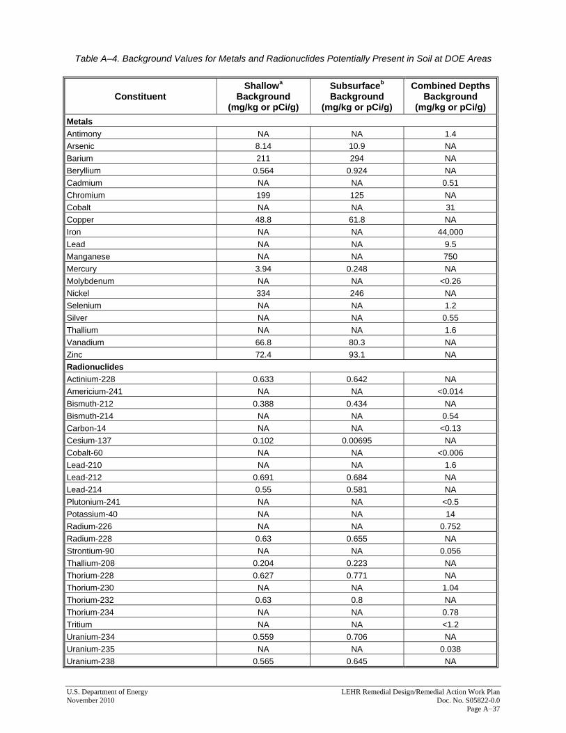
U.S. Department of Energy LEHR Remedial Design/Remedial Action Work Plan November 2010 Doc. No. S05822-0.0 Page A−37
Table A–4. Background Values for Metals and Radionuclides Potentially Present in Soil at DOE Areas
Constituent Shallowa
Background (mg/kg or pCi/g)
Subsurfaceb Background
(mg/kg or pCi/g)
Combined Depths Background
(mg/kg or pCi/g) Metals Antimony NA NA 1.4 Arsenic 8.14 10.9 NA Barium 211 294 NA Beryllium 0.564 0.924 NA Cadmium NA NA 0.51 Chromium 199 125 NA Cobalt NA NA 31 Copper 48.8 61.8 NA Iron NA NA 44,000 Lead NA NA 9.5 Manganese NA NA 750 Mercury 3.94 0.248 NA Molybdenum NA NA <0.26 Nickel 334 246 NA Selenium NA NA 1.2 Silver NA NA 0.55 Thallium NA NA 1.6 Vanadium 66.8 80.3 NA Zinc 72.4 93.1 NA Radionuclides Actinium-228 0.633 0.642 NA Americium-241 NA NA <0.014 Bismuth-212 0.388 0.434 NA Bismuth-214 NA NA 0.54 Carbon-14 NA NA <0.13 Cesium-137 0.102 0.00695 NA Cobalt-60 NA NA <0.006 Lead-210 NA NA 1.6 Lead-212 0.691 0.684 NA Lead-214 0.55 0.581 NA Plutonium-241 NA NA <0.5 Potassium-40 NA NA 14 Radium-226 NA NA 0.752 Radium-228 0.63 0.655 NA Strontium-90 NA NA 0.056 Thallium-208 0.204 0.223 NA Thorium-228 0.627 0.771 NA Thorium-230 NA NA 1.04 Thorium-232 0.63 0.8 NA Thorium-234 NA NA 0.78 Tritium NA NA <1.2 Uranium-234 0.559 0.706 NA Uranium-235 NA NA 0.038 Uranium-238 0.565 0.645 NA

Table A–4 (continued). Background Values for Metals and Radionuclides Potentially Present in Soil at
DOE Areas
LEHR Remedial Design/Remedial Action Work Plan U.S. Department of Energy Doc. No. S05822-0.0 November 2010 Page A−38
Constituent Shallowa
Background (mg/kg or pCi/g)
Subsurfaceb Background
(mg/kg or pCi/g)
Combined Depths Background
(mg/kg or pCi/g) General Chemistry Hexavalent Chromium NA NA 1.3 Nitrate NA NA 36 Notes: a Shallow soil background is representative of soil in the 0-to-4-foot depth interval. b Subsurface soil background is representative of soil deeper than 4 feet below ground surface and less than or equal to approximately 40 feet below ground surface. Abbreviations: mg/kg = Milligrams per kilogram pCi/g = Picocuries per gram NA = Not applicable <n = Not detected in background; detection limit of n Other approaches to designating soils as clean or contaminated may be used as long as regulatory approval is obtained for such approaches. 6.3 Waste Disposal Analytical data and process knowledge shall be used to certify and designate waste as clean, nonhazardous, hazardous, or radioactive, in accordance with applicable federal and State requirements. A designation report containing the technical basis for waste classification in accordance with all applicable regulatory requirements shall be completed to document the designation decision. The report shall be reviewed and accepted by an environmental professional and submitted to the EH&S Unit for review and approval. All off-site disposal of waste soil will be in a landfill that complies with the Off-Site Rule of Section 121(d)(3) of CERCLA (40 CFR 300.440). The landfill may require specific analytical testing to document that chemical concentrations do not exceed their waste acceptance criteria. 6.3.1 Clean Soil Clean excavated soil will be reused on site (such as for fill or other construction purposes), to the extent practicable. If on-site reuse is not practical or cost-effective, clean waste soil will be disposed of in a qualifying landfill (see Section 6.3 above). 6.3.2 Nonhazardous Soil Excavated soil classified as nonhazardous will be disposed of in a Class II or other acceptable landfill, depending on the acceptance criteria of the landfill. Such soil may not have any added radioactivity (i.e., above activities found in background soils). The landfill may require analytical testing of the soil to document that chemical concentrations do not exceed their waste acceptance criteria.
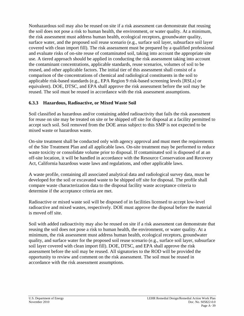
U.S. Department of Energy LEHR Remedial Design/Remedial Action Work Plan November 2010 Doc. No. S05822-0.0 Page A−39
Nonhazardous soil may also be reused on site if a risk assessment can demonstrate that reusing the soil does not pose a risk to human health, the environment, or water quality. At a minimum, the risk assessment must address human health, ecological receptors, groundwater quality, surface water, and the proposed soil reuse scenario (e.g., surface soil layer, subsurface soil layer covered with clean import fill). The risk assessment must be prepared by a qualified professional and evaluate risks of on-site reuse of contaminated soil, taking into account the appropriate site use. A tiered approach should be applied in conducting the risk assessment taking into account the contaminant concentrations, applicable standards, reuse scenarios, volumes of soil to be reused, and other applicable factors. The initial tier of this assessment shall consist of a comparison of the concentrations of chemical and radiological constituents in the soil to applicable risk-based standards (e.g., EPA Region 9 risk-based screening levels [RSLs] or equivalent). DOE, DTSC, and EPA shall approve the risk assessment before the soil may be reused. The soil must be reused in accordance with the risk assessment assumptions. 6.3.3 Hazardous, Radioactive, or Mixed Waste Soil Soil classified as hazardous and/or containing added radioactivity that fails the risk assessment for reuse on site may be treated on site or be shipped off site for disposal at a facility permitted to accept such soil. Soil removed from the DOE areas subject to this SMP is not expected to be mixed waste or hazardous waste. On-site treatment shall be conducted only with agency approval and must meet the requirements of the Site Treatment Plan and all applicable laws. On-site treatment may be performed to reduce waste toxicity or consolidate volume prior to disposal. If contaminated soil is disposed of at an off-site location, it will be handled in accordance with the Resource Conservation and Recovery Act, California hazardous waste laws and regulations, and other applicable laws. A waste profile, containing all associated analytical data and radiological survey data, must be developed for the soil or excavated waste to be shipped off site for disposal. The profile shall compare waste characterization data to the disposal facility waste acceptance criteria to determine if the acceptance criteria are met. Radioactive or mixed waste soil will be disposed of in facilities licensed to accept low-level radioactive and mixed wastes, respectively. DOE must approve the disposal before the material is moved off site. Soil with added radioactivity may also be reused on site if a risk assessment can demonstrate that reusing the soil does not pose a risk to human health, the environment, or water quality. At a minimum, the risk assessment must address human health, ecological receptors, groundwater quality, and surface water for the proposed soil reuse scenario (e.g., surface soil layer, subsurface soil layer covered with clean import fill). DOE, DTSC, and EPA shall approve the risk assessment before the soil may be reused. All signatories to the ROD will be provided the opportunity to review and comment on the risk assessment. The soil must be reused in accordance with the risk assessment assumptions.
LEHR Remedial Design/Remedial Action Work Plan U.S. Department of Energy Doc. No. S05822-0.0 November 2010 Page A−40
7.0 Inspections As frequently as appropriate for the work being performed, the EH&S Unit shall inspect active excavation, digging, or other soil-disturbing activities authorized by the EH&S Unit to ensure that they comply with this SMP. Stop-work orders shall be promptly issued if any noncompliance has occurred. An investigation shall be conducted to determine the cause of, and parties responsible for, any noncompliance before work activities resume. DOE and all signatories to the ROD shall be promptly notified of the findings of the investigation if the occurrence put human health or the environment at risk. Evidence of unauthorized soil disturbance shall be documented and reported to DOE, DTSC, and EPA within 30 days of its identification. Corrective action, if required, shall be developed in coordination with DOE, DTSC, EPA, other signatories to the ROD as appropriate, and the EH&S Unit.
8.0 Documentation 8.1 Recordkeeping The following documentation must be maintained and submitted to the EH&S Unit for all soil-disturbing projects:
• Work Plans
• Analytical data
• Soil designation reports
• Hazardous waste manifests
• Manifest fee documents
• Bills of Lading for Disposal 8.2 Soil Disturbance Reports A soil disturbance report shall be submitted to the EH&S Unit at the completion of soil-disturbing activities. At a minimum, the report shall include:
• A description of work performed;
• A map, with the project location and location(s) of soil disturbance, soil removal, soil reuse, and/or placement of imported soil;
• A map of waste storage and stockpile locations;
• A map of sampling locations, as appropriate;
• Contaminants of concern;
• EPA analytical methods;
• Analytical data results, including associated laboratory quality control reports;

U.S. Department of Energy LEHR Remedial Design/Remedial Action Work Plan November 2010 Doc. No. S05822-0.0 Page A−41
• A risk assessment with a recommended course of action;
• Waste characterization data;
• Waste profiles and manifests for soil disposed of at off-site disposal facilities;
• Volumes of soil reused on site along with surveyed coordinates indicating the location(s) where such soil was placed; and
• Analytical data for an imported soil placed on site. 8.3 Annual Reports Per the requirements of the ROD and as described in the RD/RAWP, DOE shall submit a written land-use covenant report to all ROD signatories annually. Reports shall be submitted within 30 days of the anniversary date of the ROD signature date and shall include:
• Inspection results;
• A certification attesting to compliance with the terms and conditions of the land-use covenant; and
• A discussion of any soil-disturbing activities and the final disposal of any wastes generated, any violations of the land-use covenant, and any action taken to ensure compliance with the land-use covenant.
These reports shall discuss SMP implementation and summarize the data and information described in Sections 8.1 and 8.2 above. 8.4 Audits DOE shall audit the implementation of this SMP as needed but no less frequently than every 5 years. The audit shall review:
• Compliance with this SMP,
• Safety documentation,
• Soil reuse approvals,
• Waste disposal records, and
• Incidents and corrective actions. The results of the audits shall be included in 5-year reviews. 8.5 5-Year Reviews Sites that have remaining hazardous substances, pollutants, or contaminants above levels that allow for unlimited use and unrestricted exposure after remedial actions must be reviewed every 5 years to ensure protection of human health and the environment. DOE will conduct a 5-year review in accordance with the requirement provided in the RD/RAWP, as well as any regulations, policies, and guidance applicable at the time. Any recommended SMP modification will be addressed during these reviews.
LEHR Remedial Design/Remedial Action Work Plan U.S. Department of Energy Doc. No. S05822-0.0 November 2010 Page A−42
9.0 References
DHS (Department of Homeland Security), 1997. The Procedures Manual of the Environmental Measurements Laboratory, New York, New York, February. DOE Order 5400.5, Change 2, Radioactive Protection of the Public and the Environment, January 7, 1993. DOE (U.S. Department of Energy), 2005. Site Management and Long-Term Surveillance and Maintenance Plan for the U.S. Department of Energy Laboratory for Energy-Related Health Research Federal Facility, Davis, California, DOE-LM/GJ897-2005, DOE Office of Legacy Management, October. DOE (U.S. Department of Energy), 2009a. Record of Decision for DOE Areas at the Laboratory for Energy-Related Health Research, University of California, Davis, LMS/LEH/S05069, September. DOE (U.S. Department of Energy), 2009b. Memorandum of Agreement between the United States Department of Energy and the Regents of the University of California Regarding the Investigation, Remediation, Long-Term Surveillance, Maintenance, and Contingent Remediation of the Laboratory for Energy-Related Health Research at the University of California, Davis. EPA (U.S. Environmental Protection Agency), 1980. Radioactive Strontium in Drinking Water, EPA Method 905.0, Cincinnati, Ohio, August. EPA (U.S. Environmental Protection Agency), 1993. Determination of Inorganic Anions by Ion Chromatography, Rev. 2.1, Method 300.0, Cincinnati, Ohio, August. EPA (U.S. Environmental Protection Agency), 1999. California Department of Toxic Substances Control (DTSC), Central Valley Regional Water Quality Control Board (CRWQCB), California Department of Health Services (DHS), and DOE, Federal Facility Agreement under CERCLA Section 120, Administrative Docket Number: 99 17, In the Matter of: The U.S. Department of Energy Laboratory for Energy-Related Health Research. EPA (U.S. Environmental Protection Agency), 2006. Data Quality Assessment: Statistical Methods for Practitioners, EPA QA/G-9S, EPA/240/B-06/003, Washington, DC, February. EPA (U.S. Environmental Protection Agency), 2007. Test Methods for Evaluating Solid Waste, Physical/Chemical Methods, 3rd ed., SW-846, February. EPA (U.S. Environmental Protection Agency), 2009. ProUCL 4.0 for Environmental Applications for Data Sets With and Without Nondetect Observations, http://www.epa.gov/osp/hstl/tsc/software.htm. 62 FR 51844–51845. U.S. Department of Energy, “Certification of the Radiological Condition of Four Buildings at the Laboratory for Energy-Related Health Research, Davis, California,” Federal Register, October 3, 1997.

U.S. Department of Energy LEHR Remedial Design/Remedial Action Work Plan November 2010 Doc. No. S05822-0.0 Page A−43
Gilbert, R.O., 1987. Statistical Methods for Environmental Pollution Monitoring, John Wiley and Sons, New York, New York. UC Davis (University of California, Davis), 2004. Revised LEHR/SCDS Site-Wide Risk Assessment, Volume I: Human Health Risk Assessment, University of California, Davis, March. UC Davis (University of California, Davis), 2006. Final LEHR/SCDS Site-Wide Ecological Risk Assessment, University of California, Davis, September 7. Weiss (Weiss Associates), 2000. Final Work Plan for the Removal Actions at Southwest Trenches, Ra/Sr Treatment Systems, and Domestic Septic System Areas for the Laboratory for Energy-Related Health Research, Rev. 0, University of California, Davis, July 24. Weiss (Weiss Associates), 2005. Site-Wide Risk Assessment, Volume I: Human Health Risk Assessment (Part B Risk Characterization for DOE Areas), Rev. 0, University of California, Davis, September 30.

LEHR Remedial Design/Remedial Action Work Plan U.S. Department of Energy Doc. No. S05822-0.0 November 2010 Page A−44
This page intentionally left blank
Attachment A
Tables of Contaminants Detected at Concentrations Above Site Background (0−10 Feet Below Ground Surface)
This page intentionally left blank
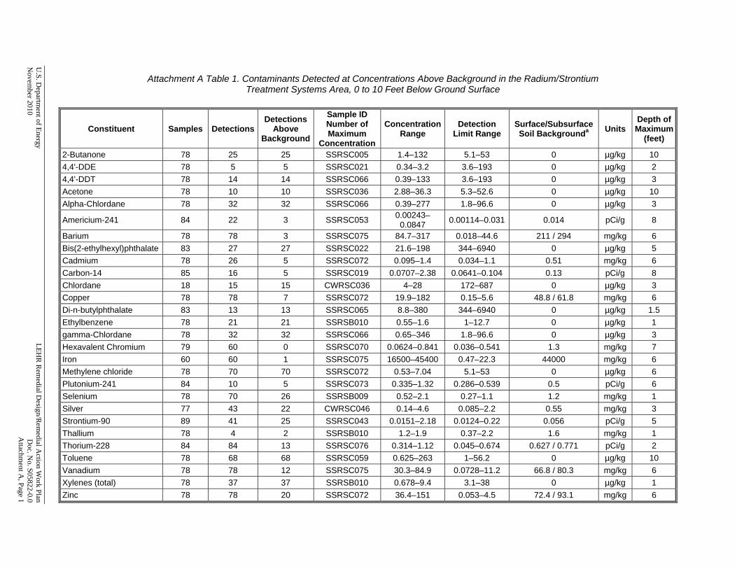
U.S. D
epartment of Energy
LEH
R R
emedial D
esign/Rem
edial Action W
ork Plan N
ovember 2010
D
oc. No. S05822-0.0
Attachm
ent A, Page 1
Attachment A Table 1. Contaminants Detected at Concentrations Above Background in the Radium/Strontium
Treatment Systems Area, 0 to 10 Feet Below Ground Surface
Constituent Samples DetectionsDetections
Above Background
Sample ID Number of Maximum
Concentration
Concentration Range
Detection Limit Range
Surface/Subsurface Soil Backgrounda Units
Depth of Maximum
(feet)
2-Butanone 78 25 25 SSRSC005 1.4–132 5.1–53 0 µg/kg 10 4,4'-DDE 78 5 5 SSRSC021 0.34–3.2 3.6–193 0 µg/kg 2 4,4'-DDT 78 14 14 SSRSC066 0.39–133 3.6–193 0 µg/kg 3 Acetone 78 10 10 SSRSC036 2.88–36.3 5.3–52.6 0 µg/kg 10 Alpha-Chlordane 78 32 32 SSRSC066 0.39–277 1.8–96.6 0 µg/kg 3
Americium-241 84 22 3 SSRSC053 0.00243–0.0847 0.00114–0.031 0.014 pCi/g 8
Barium 78 78 3 SSRSC075 84.7–317 0.018–44.6 211 / 294 mg/kg 6 Bis(2-ethylhexyl)phthalate 83 27 27 SSRSC022 21.6–198 344–6940 0 µg/kg 5 Cadmium 78 26 5 SSRSC072 0.095–1.4 0.034–1.1 0.51 mg/kg 6 Carbon-14 85 16 5 SSRSC019 0.0707–2.38 0.0641–0.104 0.13 pCi/g 8 Chlordane 18 15 15 CWRSC036 4–28 172–687 0 µg/kg 3 Copper 78 78 7 SSRSC072 19.9–182 0.15–5.6 48.8 / 61.8 mg/kg 6 Di-n-butylphthalate 83 13 13 SSRSC065 8.8–380 344–6940 0 µg/kg 1.5 Ethylbenzene 78 21 21 SSRSB010 0.55–1.6 1–12.7 0 µg/kg 1 gamma-Chlordane 78 32 32 SSRSC066 0.65–346 1.8–96.6 0 µg/kg 3 Hexavalent Chromium 79 60 0 SSRSC070 0.0624–0.841 0.036–0.541 1.3 mg/kg 7 Iron 60 60 1 SSRSC075 16500–45400 0.47–22.3 44000 mg/kg 6 Methylene chloride 78 70 70 SSRSC072 0.53–7.04 5.1–53 0 µg/kg 6 Plutonium-241 84 10 5 SSRSC073 0.335–1.32 0.286–0.539 0.5 pCi/g 6 Selenium 78 70 26 SSRSB009 0.52–2.1 0.27–1.1 1.2 mg/kg 1 Silver 77 43 22 CWRSC046 0.14–4.6 0.085–2.2 0.55 mg/kg 3 Strontium-90 89 41 25 SSRSC043 0.0151–2.18 0.0124–0.22 0.056 pCi/g 5 Thallium 78 4 2 SSRSB010 1.2–1.9 0.37–2.2 1.6 mg/kg 1 Thorium-228 84 84 13 SSRSC076 0.314–1.12 0.045–0.674 0.627 / 0.771 pCi/g 2 Toluene 78 68 68 SSRSC059 0.625–263 1–56.2 0 µg/kg 10 Vanadium 78 78 12 SSRSC075 30.3–84.9 0.0728–11.2 66.8 / 80.3 mg/kg 6 Xylenes (total) 78 37 37 SSRSB010 0.678–9.4 3.1–38 0 µg/kg 1 Zinc 78 78 20 SSRSC072 36.4–151 0.053–4.5 72.4 / 93.1 mg/kg 6
Attachment A Table 1 (continued). Contaminants Detected at Concentrations Above Background in the Radium/Strontium
Treatment Systems Area, 0 to 10 Feet Below Ground Surface
LEHR
Rem
edial Design/R
emedial A
ction Work Plan
U
.S. Departm
ent of Energy D
oc. No. S05822-0.0
N
ovember 2010
Attachm
ent A, Page 2
Notes: Concentrations reflect post-removal-action conditions. Includes inorganic constituents with statistical test results indicating above-background concentrations in soil from 0 to 10 feet below ground surface (UC Davis 2004). Includes organic constituents with detection frequency of 5 percent or more in soil from 0 to 10 feet below ground surface (SWRA Table 2 [UC Davis 2004]). Copy of soil data provided in Attachment C. a Background values for surface soil (0 to 4 feet below ground surface) and subsurface soil (greater than 4 feet below ground surface) provided for constituents with statistically significant vertical stratification (Weiss 2000). Single background value provided for non-stratified constituents. Abbreviations: µg/kg = micrograms per kilogram DDE = dichlorodiphenyldichloroethylene DDT = dichlorodiphenyltrichloroethane mg/kg = milligrams per kilogram pCi/g = picocuries per gram SWRA = Site-Wide Risk Assessment

U.S. D
epartment of Energy
LEH
R R
emedial D
esign/Rem
edial Action W
ork Plan N
ovember 2010
D
oc. No. S05822-0.0
Attachm
ent A, Page 3
Attachment A Table 2. Contaminants Detected at Concentrations Above Background in the
Domestic Septic System 3, 0 to 10 Feet Below Ground Surface
Constituent Samples DetectionsDetections
Above Background
Sample ID Number of Maximum
Concentration
Concentration Range
Detection Limit Range
Surface/Subsurface Soil Backgrounda Units
Depth of Maximum
(feet)
1,3-Dichlorobenzene 10 1 1 SSIBF155 0.286–0.286 9.6–367 0 µg/kg 6.5 1,4-Dichlorobenzene 10 2 2 CSD3C001 0.579–0.819 9.6–367 0 µg/kg 9 2-Butanone 10 2 2 LEHR-S-T304 2.55–4 9.6–12 0 µg/kg 8 2-Methylnaphthalene 10 7 7 SSD3C024 0.34–0.8 333–709 0 µg/kg 8 Acetone 10 3 3 CSD3C001 6.46–30.9 9.6–12 0 µg/kg 9 alpha-Chlordane 26 18 18 SSD3C047DL 0.063–161 1.7–38.2 0 µg/kg 5.9 Aroclor-1254 7 2 2 SSD3C024 21.7–225 33.3–69.4 0 µg/kg 8 Benzaldehyde 8 2 2 SSD3C024 15.6–53.8 333–709 0 µg/kg 8 bis(2-Ethylhexyl)phthalate 10 10 10 SSD3C036 11.5–101 333–709 0 µg/kg 5.5 Butylbenzylphthalate 10 3 3 SSD3C030 0.59–5.5 333–709 0 µg/kg 7 Cesium-137 31 7 5 LEHR-S-T301 0.0049–0.126 0.00209–0.053 0.102 / 0.00695 pCi/g 8 Dieldrin 7 1 1 SSIBF156 2.4–2.4 3.3–19.8 0 µg/kg 4.5 Diethylphthalate 10 4 4 SSD3C030 0.6–1.2 333–709 0 µg/kg 7 Di-n-butylphthalate 10 7 7 SSD3C036 2.9–20.6 333–709 0 µg/kg 5.5 Di-n-octylphthalate 10 1 1 SSIBF155 0.49–0.49 333–709 0 µg/kg 6.5 Endrin aldehyde 7 1 1 SSIBF156 0.35–0.35 3.3–6.9 0 µg/kg 4.5 Formaldehyde 20 19 19 SSD3C041 0.21–1.3 0.1–0.11 0 mg/kg 5.9 gamma-Chlordane 26 20 20 SSD3C047DL 0.13–294 1.7–38.2 0 µg/kg 5.9 Hexachlorobenzene 10 1 1 SSD3C024 125–125 333–709 0 µg/kg 8 Isopropylbenzene 8 1 1 SSIBF155 1.47–1.47 9.6–11.8 0 µg/kg 6.5 Lead-210 31 10 1 LEHR-S-T301 0.48–4.4 0.0691–1.76 1.6 pCi/g 8 Methyl acetate 8 1 1 SSD3C028 3.4–3.4 9.6–11.8 0 µg/kg 6 Pyrene 10 2 2 SSD3C025 0.81–3.3 333–709 0 µg/kg 8 Strontium-90 25 15 12 SSD3C062 0.0281–0.591 0.0154–0.0661 0.056 pCi/g 5.2 Styrene 10 1 1 SSIBF155 0.326–0.326 9.6–12 0 µg/kg 6.5 Thallium 10 3 2 CSD3C001 1.1–2.8 0.87–5.1 1.6 mg/kg 9 Toluene 10 7 7 SSD3C019 0.638–74.7 9.6–12 0 µg/kg 10 Trichlorofluoromethane 8 1 1 SSIBF155 1.18–1.18 9.6–11.8 0 µg/kg 6.5 Zinc 10 10 1 LEHR-S-T301 37.9–258 0.1–4.3 72.4 / 93.1 mg/kg 8

Attachment A Table 2 (continued). Contaminants Detected at Concentrations Above Background in the Domestic Septic System 3, 0 to 10 Feet Below Ground Surface
LEHR
Rem
edial Design/R
emedial A
ction Work Plan
U
.S. Departm
ent of Energy D
oc. No. S05822-0.0
N
ovember 2010
Attachm
ent A, Page 4
Notes: Concentrations reflect post-removal-action conditions. Includes inorganic constituents with statistical test results indicating above-background concentrations in soil from 0 to 10 feet below ground surface (UC Davis 2004). Includes organic constituents with detection frequency of 5 percent or more in soil from 0 to 10 feet below ground surface (SWRA Table 2 [UC Davis 2004]). Copy of soil data provided in Attachment C. aBackground values for surface soil (0 to 4 feet below ground surface) and subsurface soil (greater than 4 feet below ground surface) provided for constituents with statistically significant vertical stratification (Weiss 2000). Single background value provided for non-stratified constituents. Abbreviations: µg/kg micrograms per kilogram mg/kg milligrams per kilogram pCi/g picocuries per gram SWRA Site-Wide Risk Assessment

U.S. D
epartment of Energy
LEH
R R
emedial D
esign/Rem
edial Action W
ork Plan N
ovember 2010
D
oc. No. S05822-0.0
Attachm
ent A, Page 5
Attachment A Table 3. Contaminants Detected at Concentrations Above Background in the
Domestic Septic System 4, 0 to 10 Feet Below Ground Surface
Constituent Samples DetectionsDetections
Above Background
Sample ID Number of Maximum
Concentration Concentration
Range Detection
Limit RangeSurface/SubsurfaceSoil Backgrounda Units
Depth of Maximum
(feet) 1,4-Dichlorobenzene 6 2 2 SSD4C003A/B 3.2–4.1 350–360 0 µg/kg 4.2 2-Methylnaphthalene 6 2 2 SSD4C003A/B 8.8–56.7 350–360 0 µg/kg 4.2 4,4'-DDE 5 1 1 SSD4C005 8.1–8.1 3.5–35.8 0 µg/kg 4.2 Acenaphthene 6 2 2 SSD4C003A/B 71.4–342 350–360 0 µg/kg 4.2 Acetone 6 3 3 LEHR-S-T405 2.05–23 10.5–26.4 0 µg/kg 8.5 Alpha-Chlordane 5 2 2 SSD4C003A/B 16.7–179 1.8–18.3 0 µg/kg 4.2 Anthracene 6 3 3 SSD4C003A/B 11.7–1160 350–360 0 µg/kg 4.2 Benzo(a)anthracene 6 3 3 SSD4C003A/B 50.3–3760 350–360 0 µg/kg 4.2 Benzo(a)pyrene 6 3 3 SSD4C003A/B 38.8–2380 350–360 0 µg/kg 4.2 Benzo(b)fluoranthene 6 3 3 SSD4C002A/B 35.7–2700 350–360 0 µg/kg 4.2 Benzo(ghi)perylene 6 3 3 SSD4C002A/B 26.4–1750 350–360 0 µg/kg 4.2 Benzo(k)fluoranthene 6 3 3 SSD4C003A/B 40–1530 350–360 0 µg/kg 4.2 Bis(2-Ethylhexyl)phthalate 6 6 6 SSD4C001 36.2–440 350–360 0 µg/kg 7.8 Butylbenzylphthalate 6 1 1 SSD4C002A/B 13.1–13.1 350–360 0 µg/kg 4.2 Carbazole 6 2 2 SSD4C003A/B 88.8–486 350–360 0 µg/kg 4.2 Chlordane 1 1 1 SSD4C005 181–181 89.6–89.6 0 µg/kg 4.2 Chromium 6 6 6 LEHR-S-T402 159–319 0.061–2.1 199 / 125 mg/kg 8 Chrysene 6 3 3 SSD4C003A/B 53.7–3010 350–360 0 µg/kg 4.2 Dibenzo(a,h)anthracene 6 2 2 SSD4C002A/B 9.1–1080 350–360 0 µg/kg 4.2 Dibenzofuran 6 2 2 SSD4C003A/B 33.2–187 350–360 0 µg/kg 4.2 Ethylbenzene 6 1 1 SSD4C004 0.882–0.882 1–12 0 µg/kg 7.75 Fluoranthene 6 3 3 SSD4C003A/B 80–2900 350–360 0 µg/kg 4.2 Fluorene 6 3 3 SSD4C003A/B 3.6–507 350–360 0 µg/kg 4.2 gamma-Chlordane 5 3 3 SSD4C003A/B 1–275 1.8–18.3 0 µg/kg 4.2 Heptachlor 5 1 1 SSD4C003A/B 5.8–5.8 1.8–18.3 0 µg/kg 4.2 Heptachlor Epoxide 5 1 1 SSD4C003A/B 10.7–10.7 1.8–18.3 0 µg/kg 4.2 Indeno(1,2,3-cd)pyrene 6 2 2 SSD4C003A/B 431–1470 350–360 0 µg/kg 4.2 Lead-210 6 3 1 LEHR-S-T401 0.434–4.7 0.0352–1.3 1.6 pCi/g 5.5 Methylene Chloride 6 4 4 SSD4C003A/BDL 2.89–457 5.3–53.8 0 µg/kg 4.2 Naphthalene 6 2 2 SSD4C003A/B 13.3–70.5 350–360 0 µg/kg 4.2

Attachment A Table 3 (continued). Contaminants Detected at Concentrations Above Background in the Domestic Septic System 4, 0 to 10 Feet Below Ground Surface
LEHR
Rem
edial Design/R
emedial A
ction Work Plan
U
.S. Departm
ent of Energy D
oc. No. S05822-0.0
N
ovember 2010
Attachm
ent A, Page 6 Constituent Samples Detections
Detections Above
Background
Sample ID Number of Maximum
Concentration Concentration
Range Detection
Limit RangeSurface/SubsurfaceSoil Backgrounda Units
Depth of Maximum
(feet) Phenanthrene 6 3 3 SSD4C003A/B 37.4–2880 350–360 0 µg/kg 4.2 Pyrene 6 3 3 SSD4C003A/B 75.3–5110 350–360 0 µg/kg 4.2 Selenium 6 2 2 SSD4C003A/B 1.23–2 0.376–0.74 1.2 mg/kg 4.2 Strontium-90 6 0 0 NA NA 0.028–0.47 0.056 pCi/g NA Styrene 6 1 1 SSD4C004 0.673–0.673 1–12 0 µg/kg 7.75 Toluene 6 3 3 SSD4C001DL 1.52–197 1–52.9 0 µg/kg 7.8 Xylenes (Total) 6 2 2 SSD4C004 1.02–5.6 2.1–32.3 0 µg/kg 7.75 Notes: Concentrations reflect current conditions. No removal actions have been conducted. Includes inorganic constituents with statistical test results indicating above-background concentrations in soil from 0 to 10 feet below ground surface (UC Davis 2004). Includes organic constituents with detection frequency of 5 percent or more in soil from 0 to 10 feet below ground surface. SWRA Table 2 (UC Davis 2004). Copy of soil data provided in Attachment C. aBackground values for surface soil (0 to 4 feet below ground surface) and subsurface soil (greater than 4 feet below ground surface) provided for constituents with statistically significant vertical stratification (Weiss 2000). Single background value provided for non-stratified constituents. Abbreviations: µg/kg = micrograms per kilogram DDE = dichlorodiphenyldichloroethylene mg/kg = milligrams per kilogram NA = not applicable pCi/g = picocuries per gram SWRA = Site-Wide Risk Assessment

U.S. D
epartment of Energy
LEH
R R
emedial D
esign/Rem
edial Action W
ork Plan N
ovember 2010
D
oc. No. S05822-0.0
Attachm
ent A, Page 7
Attachment A Table 4. Contaminants Detected at Concentrations Above Background in the Dry Wells A–E Area,
0 to 10 Feet Below Ground Surface
Constituent Samples Detections Detections
Above Background
Sample ID Number of Maximum
Concentration Concentration
Range Detection Limit
Range Surface/Subsurface Soil Backgrounda Units
Depth of Maximum
(feet) 2-Butanone 9 5 5 SSSTC011 7–70 11.4–20 0 µg/kg 5 Alpha-Chlordane 9 4 4 SSSTC008 0.77–6.2 1.9–2.2 0 µg/kg 8 Arsenic 13 13 0 SSSTC006 5.9–10.8 0.56–2.4 8.14 / 10.9 mg/kg 5 Barium 13 13 0 SSDWC022 148–253 0.053–49.2 211 / 294 mg/kg 10 Beryllium 13 13 0 SSDWC023 0.31–0.58 0.046–1.2 0.564 / 0.924 mg/kg 10 Carbon-14 10 1 0 SSSTC006 0.0915–0.0915 0.0768–0.53 0.13 pCi/g 5 Cobalt-60 10 0 0 NA NA 0.00499–0.051 0.006 pCi/g NA Copper 13 13 0 SSDWC023 30.5–52.4 0.22–6.1 48.8 / 61.8 mg/kg 10 Ethylbenzene 9 4 4 SSSTC011 0.749–2.24 5–12.6 0 µg/kg 5 Gamma-Chlordane 9 4 4 SSSTC008 0.76–6.7 1.9–2.2 0 µg/kg 8 Iron 13 13 0 SSSTC006 30200–40300 0.48–24.6 44000 mg/kg 5 Radium-226 10 10 0 SSSTC005 0.43–0.675 0.0298–0.3 0.752 pCi/g 6 Selenium 13 5 1 SSDWC027 0.79–1.7 0.58–1.2 1.2 mg/kg 10 Silver 13 9 7 SSDWC027 0.47–27.6 0.14–2.4 0.55 mg/kg 10 Strontium-90 10 4 3 SSSTC006 0.0521–0.153 0.0355–0.51 0.056 pCi/g 5 Thorium-228 7 7 0 SSSTC006 0.604–0.771 0.162–0.408 0.627 / 0.771 pCi/g 5 Thorium-232 7 7 1 SSSTC006 0.325–0.875 0.0303–0.153 0.63 / 0.8 pCi/g 5 Thorium-234 10 7 1 SSSTC005 0.502–0.899 0.0908–1.5 0.78 pCi/g 6 Toluene 9 6 6 SSSTC008 1.47–214 5–24.4 0 µg/kg 8 Uranium-233/234 7 7 0 SSSTC006 0.486–0.57 0.00231–0.012 0.559 / 0.706 pCi/g 5 Uranium-238 7 7 0 SSSTC006 0.461–0.599 0.00231–0.0103 0.565 / 0.645 pCi/g 5 Vanadium 13 13 1 SSDWC023 56.8–82.9 0.1–12.3 66.8 / 80.3 mg/kg 10 Zinc 13 13 1 LEHR-S-T1A01(5.0) 70.3–136 0.11–4.9 72.4 / 93.1 mg/kg 5
Attachment A Table 4 (continued). Contaminants Detected at Concentrations Above Background in the Dry Wells A–E Area, 0 to 10 Feet Below Ground Surface
LEHR
Rem
edial Design/R
emedial A
ction Work Plan
U
.S. Departm
ent of Energy D
oc. No. S05822-0.0
N
ovember 2010
Attachm
ent A, Page 8
Notes: Concentrations reflect post-removal-action conditions. Includes inorganic constituents with statistical test results indicating above-background concentrations in soil from 0 to 10 feet below ground surface (UC Davis 2004). Includes organic constituents with detection frequency of 5 percent or more in soil from 0 to 10 feet below ground surface. SWRA Table 2 (UC Davis 2004). Copy of soil data provided in Attachment C. aBackground values for surface soil (0 to 4 feet below ground surface) and subsurface soil (greater than 4 feet below ground surface) provided for constituents with statistically significant vertical stratification (Weiss 2000). Single background value provided for non-stratified constituents. Abbreviations: µg/kg micrograms per kilogram mg/kg milligrams per kilogram NA not applicable pCi/g picocuries per gram SWRA Site-Wide Risk Assessment
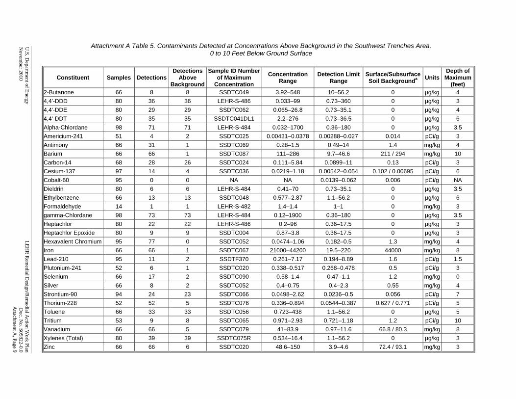
U.S. D
epartment of Energy
LEH
R R
emedial D
esign/Rem
edial Action W
ork Plan N
ovember 2010
D
oc. No. S05822-0.0
Attachm
ent A, Page 9
Attachment A Table 5. Contaminants Detected at Concentrations Above Background in the Southwest Trenches Area,
0 to 10 Feet Below Ground Surface
Constituent Samples DetectionsDetections
Above Background
Sample ID Number of Maximum
Concentration Concentration
Range Detection Limit
Range Surface/Subsurface Soil Backgrounda Units
Depth ofMaximum
(feet) 2-Butanone 66 8 8 SSDTC049 3.92–548 10–56.2 0 µg/kg 4 4,4'-DDD 80 36 36 LEHR-S-486 0.033–99 0.73–360 0 µg/kg 3 4,4'-DDE 80 29 29 SSDTC062 0.065–26.8 0.73–35.1 0 µg/kg 4 4,4'-DDT 80 35 35 SSDTC041DL1 2.2–276 0.73–36.5 0 µg/kg 6 Alpha-Chlordane 98 71 71 LEHR-S-484 0.032–1700 0.36–180 0 µg/kg 3.5 Americium-241 51 4 2 SSDTC025 0.00431–0.0378 0.00288–0.027 0.014 pCi/g 3 Antimony 66 31 1 SSDTC069 0.28–1.5 0.49–14 1.4 mg/kg 4 Barium 66 66 1 SSDTC087 111–286 9.7–46.6 211 / 294 mg/kg 10 Carbon-14 68 28 26 SSDTC024 0.111–5.84 0.0899–11 0.13 pCi/g 3 Cesium-137 97 14 4 SSDTC036 0.0219–1.18 0.00542–0.054 0.102 / 0.00695 pCi/g 6 Cobalt-60 95 0 0 NA NA 0.0139–0.062 0.006 pCi/g NA Dieldrin 80 6 6 LEHR-S-484 0.41–70 0.73–35.1 0 µg/kg 3.5 Ethylbenzene 66 13 13 SSDTC048 0.577–2.87 1.1–56.2 0 µg/kg 6 Formaldehyde 14 1 1 LEHR-S-482 1.4–1.4 1–1 0 mg/kg 3 gamma-Chlordane 98 73 73 LEHR-S-484 0.12–1900 0.36–180 0 µg/kg 3.5 Heptachlor 80 22 22 LEHR-S-486 0.2–96 0.36–17.5 0 µg/kg 3 Heptachlor Epoxide 80 9 9 SSDTC004 0.87–3.8 0.36–17.5 0 µg/kg 3 Hexavalent Chromium 95 77 0 SSDTC052 0.0474–1.06 0.182–0.5 1.3 mg/kg 4 Iron 66 66 1 SSDTC067 21000–44200 19.5–220 44000 mg/kg 8 Lead-210 95 11 2 SSDTF370 0.261–7.17 0.194–8.89 1.6 pCi/g 1.5 Plutonium-241 52 6 1 SSDTC020 0.338–0.517 0.268–0.478 0.5 pCi/g 3 Selenium 66 17 2 SSDTC090 0.58–1.4 0.47–1.1 1.2 mg/kg 0 Silver 66 8 2 SSDTC052 0.4–0.75 0.4–2.3 0.55 mg/kg 4 Strontium-90 94 24 23 SSDTC066 0.0498–2.62 0.0236–0.5 0.056 pCi/g 7 Thorium-228 52 52 5 SSDTC076 0.336–0.894 0.0544–0.387 0.627 / 0.771 pCi/g 5 Toluene 66 33 33 SSDTC056 0.723–438 1.1–56.2 0 µg/kg 5 Tritium 53 9 8 SSDTC065 0.971–2.93 0.721–1.18 1.2 pCi/g 10 Vanadium 66 66 5 SSDTC079 41–83.9 0.97–11.6 66.8 / 80.3 mg/kg 8 Xylenes (Total) 80 39 39 SSDTC075R 0.534–16.4 1.1–56.2 0 µg/kg 3 Zinc 66 66 6 SSDTC020 48.6–150 3.9–4.6 72.4 / 93.1 mg/kg 3

Attachment A Table 5 (continued). Contaminants Detected at Concentrations Above Background in the Southwest Trenches Area, 0 to 10 Feet Below Ground Surface
LEHR
Rem
edial Design/R
emedial A
ction Work Plan
U
.S. Departm
ent of Energy D
oc. No. S05822-0.0
N
ovember 2010
Attachm
ent A, Page 10
Notes: Concentrations reflect post-removal-action conditions. Includes inorganic constituents with statistical test results indicating above-background concentrations in soil from 0 to 10 feet below ground surface (UC Davis 2004). Includes organic constituents with detection frequency of 5 percent or more in soil from 0 to 10 feet below ground surface. SWRA Table 2 (UC Davis 2004). Copy of soil data provided in Attachment C. a Background values for surface soil (0 to 4 feet below ground surface) and subsurface soil (greater than 4 feet below ground surface) provided for constituents with statistically significant vertical stratification (Weiss 2000). Single background value provided for non-stratified constituents. Abbreviations: µg/kg = micrograms per kilogram DDD = dichlorodiphenyldichloroethane DDE = dichlorodiphenyldichloroethylene DDT = dichlorodiphenyltrichloroethane mg/kg = milligrams per kilogram NA = not applicable pCi/g = picocuries per gram SWRA = Site-Wide Risk Assessment

U.S. D
epartment of Energy
LEH
R R
emedial D
esign/Rem
edial Action W
ork Plan N
ovember 2010
D
oc. No. S05822-0.0
Attachm
ent A, Page 11
Attachment A Table 6. Contaminants Detected at Concentrations Above Background in the Eastern Dog Pens Area
Constituent Samples DetectionsDetections
Above Background
Sample ID Number of Maximum
Concentration
Concentration Range
Detection Limit Range
Surface/Subsurface Soil Backgrounda Units
Depth of Maximum
(feet)
4,4'-DDD 36 7 7 SSDP0343 0.82–3.3 3.4–4.2 0 µg/kg 1.02 4,4'-DDE 36 3 3 SSDP0330 0.3–3.6 3.4–4.2 0 µg/kg 2.01 4,4'-DDT 36 5 5 SSDP0318 0.48–5.8 3.4–4.2 0 µg/kg 1.17 Alpha-Chlordane 36 12 12 SSDP0346DL1 0.38–47.8 1.7–3.7 0 µg/kg 0.02 Aroclor-1254 37 2 2 SSDP0319 24.3–54.9 34–42.2 0 µg/kg 1.17 Chromium 37 37 3 SSDP0336 90.7–251 2–2.4 199 / 125 mg/kg 0.96 Cobalt-60 37 0 0 NA NA 0.00463–0.00773 0.006 pCi/g NA Dieldrin 37 13 13 SSDP0338DL1 0.76–223 3.4–18.1 0 µg/kg 0 gamma-Chlordane 36 12 12 SSDP0346DL1 0.4–43.4 1.7–3.7 0 µg/kg 0.02 Hexavalent Chromium 37 36 0 SSDP0320 0.077–0.673 0.204–0.254 1.3 mg/kg 3.17 Lead-210 37 10 0 SSDP0334 0.356–1.33 0.0656–2.09 1.6 pCi/g 0.41 Strontium-90 53 14 7 GSDP0004 0.023–0.201 0.0143–0.0493 0.056 pCi/g 1.5 Tritium 42 0 0 NA NA 0.874–1.18 1.2 pCi/g NA
Notes: Concentrations reflects current conditions after completion of a maintenance action to remove all concrete materials from the area. Includes inorganic constituents with statistical test results indicating above-background concentrations in soil from 0 to 10 feet below ground surface (UC Davis 2004). Includes organic constituents with detection frequency of 5 percent or more in soil from 0 to 10 feet below ground surface. SWRA Table 2 (UC Davis 2004). Copy of soil data provided in Attachment C. a Background values for surface soil (0 to 4 feet below ground surface) and subsurface soil (greater than 4 feet below ground surface) provided for constituents with statistically significant vertical stratification (Weiss 2000). Single background value provided for non-stratified constituents. Abbreviations: µg/kg = micrograms per kilogram DDD = dichlorodiphenyldichloroethane DDE = dichlorodiphenyldichloroethylene DDT = dichlorodiphenyltrichloroethane mg/kg = milligrams per kilogram NA = not applicable pCi/g = picocuries per gram SWRA = Site-Wide Risk Assessment

LEHR Remedial Design/Remedial Action Work Plan U.S. Department of Energy Doc. No. S05822-0.0 November 2010 Attachment A, Page 12
This page intentionally left blank

Attachment B
Soil Sample Location Figures

This page intentionally left blank
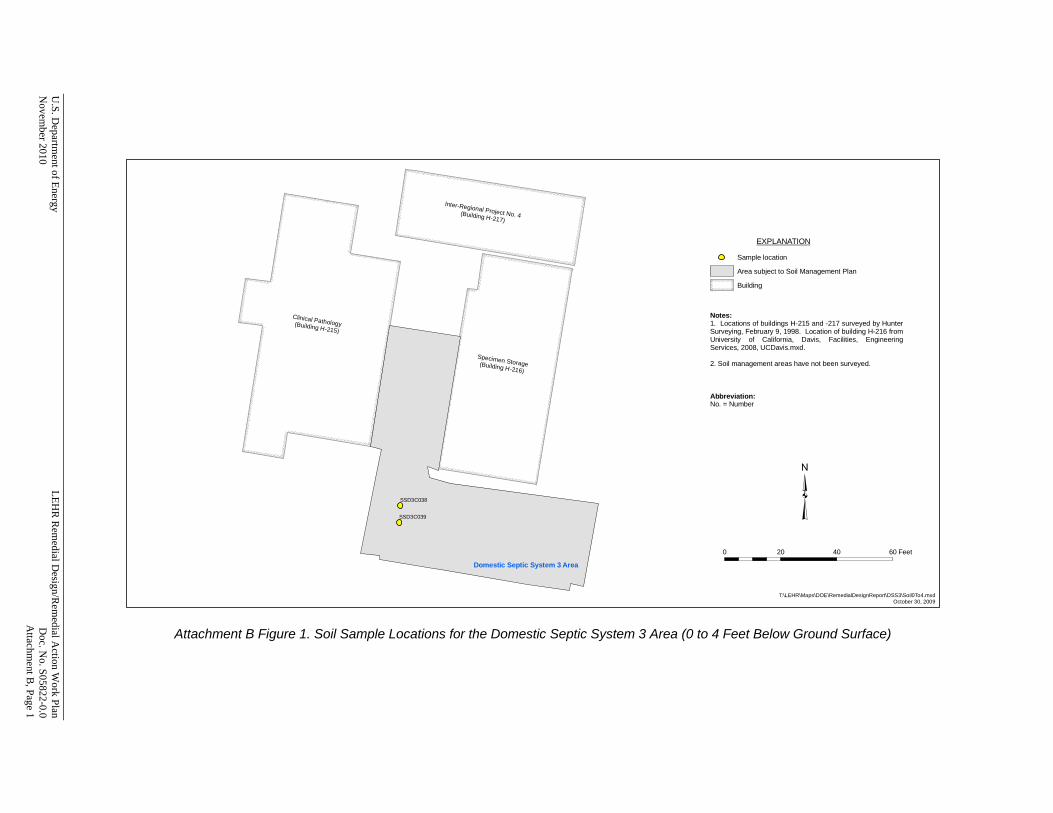
U.S. D
epartment of Energy
LEH
R R
emedial D
esign/Rem
edial Action W
ork Plan N
ovember 2010
D
oc. No. S05822-0.0
Attachm
ent B, Page 1
SSD3C038
SSD3C039
EXPLANATION
Sample location
Area subject to Soil Management Plan
Building
T:\LEHR\Maps\DOE\RemedialDesignReport\DSS3\Soil0To4.mxdOctober 30, 2009
0 20 40 60 Feet
Notes:1. Locations of buildings H-215 and -217 surveyed by HunterSurveying, February 9, 1998. Location of building H-216 fromUniversity of California, Davis, Facilities, EngineeringServices, 2008, UCDavis.mxd.
2. Soil management areas have not been surveyed.
Abbreviation:No. = Number
Domestic Septic System 3 Area
Clinical Pathology (Building H-215)
Specimen Storage(Building H-216)
Inter-Regional Project No. 4 (Building H-217)
Attachment B Figure 1. Soil Sample Locations for the Domestic Septic System 3 Area (0 to 4 Feet Below Ground Surface)
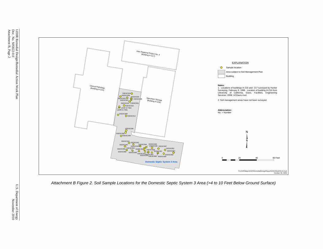
LEHR
Rem
edial Design/R
emedial A
ction Work Plan
U
.S. Departm
ent of Energy D
oc. No. S05822-0.0
N
ovember 2010
Attachm
ent B, Page 2
CSD3C001
LEHR-S-T301LEHR-S-T304
SSD3C001SSD3C002
SSD3C006
SSD3C009SSD3C012
SSD3C015SSD3C019
SSD3C024
SSD3C025SSD3C026
SSD3C028
SSD3C029
SSD3C030SSD3C031
SSD3C036
SSD3C040
SSD3C041SSD3C042
SSD3C043SSD3C044 SSD3C045
SSD3C046 SSD3C047
SSD3C048
SSD3C052SSD3C057
SSD3C058SSD3C059SSD3C060
SSD3C061
SSD3C062SSD3C063
SSD3C064SSD3C065
SSD3C066SSIBF155
EXPLANATION
Sample location
Area subject to Soil Management Plan
Building
T:\LEHR\Maps\DOE\RemedialDesignReport\DSS3\Soil4To10.mxdOctober 30, 2009
0 20 40 60 Feet
Notes:1. Locations of buildings H-215 and -217 surveyed by HunterSurveying, February 9, 1998. Location of building H-216 fromUniversity of California, Davis, Facilities, EngineeringServices, 2008, UCDavis.mxd.
2. Soil management areas have not been surveyed.
Abbreviation:No. = Number
Domestic Septic System 3 Area
Clinical Pathology (Building H-215)
Specimen Storage(Building H-216)
Inter-Regional Project No. 4 (Building H-217)
Attachment B Figure 2. Soil Sample Locations for the Domestic Septic System 3 Area (>4 to 10 Feet Below Ground Surface)

U.S. D
epartment of Energy
LEH
R R
emedial D
esign/Rem
edial Action W
ork Plan N
ovember 2010
D
oc. No. S05822-0.0
Attachm
ent B, Page 3
LEHR-S-T302LEHR-S-T303
LEHR-S-T305
LEHR-S-T306
SSD3C003SSD3C004 SSD3C005
SSD3C007SSD3C008
SSD3C010 SSD3C011
SSD3C013SSD3C014
SSD3C016SSD3C017
SSD3C032
SSD3C033
SSD3C034SSD3C049
SSD3C050 SSD3C051SSD3C053
SSD3C054
SSD3C055
SSD3C056
SSD3DL01
SSD3DL02
SSD3DL03
SSD3DL04SSD3DL05
SSD3DL06
SSD3DL07 SSD3DL08
SSD3DL09SSD3DL10
SSD3DL11
SSD3DL12
EXPLANATION
Sample location
Area subject to Soil Management Plan
Building
T:\LEHR\Maps\DOE\RemedialDesignReport\DSS3\Soil10Plus.mxdOctober 30, 2009
0 20 40 60 Feet
Notes:1. Locations of buildings H-215 and -217 surveyed by HunterSurveying, February 9, 1998. Location of building H-216 fromUniversity of California, Davis, Facilities, EngineeringServices, 2008, UCDavis.mxd.
2. Soil management areas have not been surveyed.
Abbreviation:No. = Number
Domestic Septic System 3 Area
Clinical Pathology (Building H-215)
Specimen Storage(Building H-216)
Inter-Regional Project No. 4 (Building H-217)
Attachment B Figure 3. Soil Sample Locations for the Domestic Septic System 3 Area (>10 to 40 Feet Below Ground Surface)
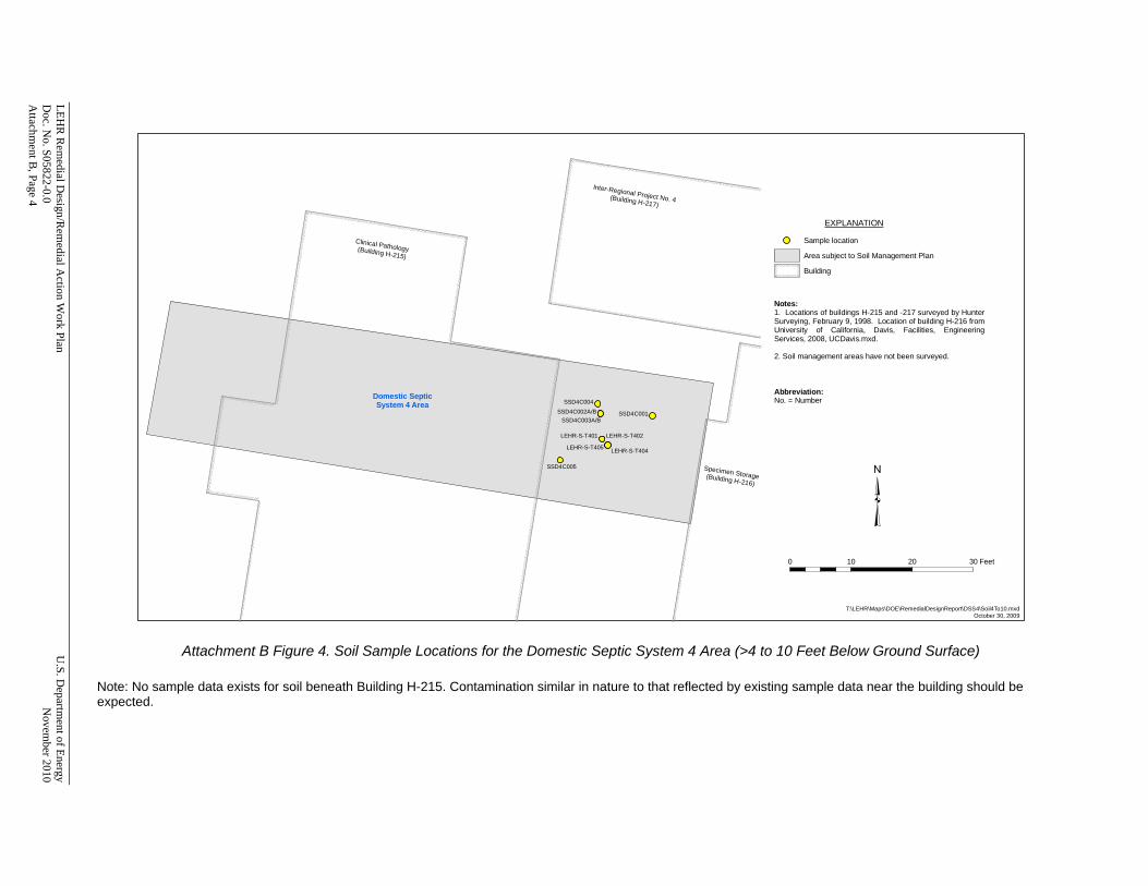
LEHR
Rem
edial Design/R
emedial A
ction Work Plan
U
.S. Departm
ent of Energy D
oc. No. S05822-0.0
N
ovember 2010
Attachm
ent B, Page 4
LEHR-S-T401 LEHR-S-T402
LEHR-S-T404LEHR-S-T405
SSD4C001SSD4C002A/BSSD4C003A/B
SSD4C004
SSD4C005
EXPLANATION
Sample location
Area subject to Soil Management Plan
Building
T:\LEHR\Maps\DOE\RemedialDesignReport\DSS4\Soil4To10.mxdOctober 30, 2009
0 10 20 30 Feet
Notes:1. Locations of buildings H-215 and -217 surveyed by HunterSurveying, February 9, 1998. Location of building H-216 fromUniversity of California, Davis, Facilities, EngineeringServices, 2008, UCDavis.mxd.
2. Soil management areas have not been surveyed.
Abbreviation:No. = NumberDomestic Septic
System 4 Area
Clinical Pathology (Building H-215)
Inter-Regional Project No. 4 (Building H-217)
Specimen Storage(Building H-216)
Attachment B Figure 4. Soil Sample Locations for the Domestic Septic System 4 Area (>4 to 10 Feet Below Ground Surface) Note: No sample data exists for soil beneath Building H-215. Contamination similar in nature to that reflected by existing sample data near the building should be expected.

U.S. D
epartment of Energy
LEH
R R
emedial D
esign/Rem
edial Action W
ork Plan N
ovember 2010
D
oc. No. S05822-0.0
Attachm
ent B, Page 5
LEHR-S-T403
LEHR-S-T406
SSD4DL02SSD4DL03
SSD4DL04
SSD4DL05
SSD4DL06SSD4DL07
EXPLANATION
Sample location
Area subject to Soil Management Plan
Building
T:\LEHR\Maps\DOE\RemedialDesignReport\DSS4\Soil10Plus.mxdOctober 30, 2009
0 10 20 30 Feet
Notes:1. Locations of buildings H-215 and -217 surveyed by HunterSurveying, February 9, 1998. Location of building H-216 fromUniversity of California, Davis, Facilities, EngineeringServices, 2008, UCDavis.mxd.
2. Soil management areas have not been surveyed.
Abbreviation:No. = NumberDomestic Septic
System 4 Area
Clinical Pathology (Building H-215)
Inter-Regional Project No. 4 (Building H-217)
Specimen Storage(Building H-216)
Attachment B Figure 5. Soil Sample Locations for the Domestic Septic System 4 Area (>10 to 37.8 Feet Below Ground Surface)

LEHR
Rem
edial Design/R
emedial A
ction Work Plan
U
.S. Departm
ent of Energy D
oc. No. S05822-0.0
N
ovember 2010
Attachm
ent B, Page 6
LEHR-S-T1A01(5.0)
LEHR-S-T1A02(5.0)LEHR-S-T1A03(7.5)
LEHR-S-T1A05
LEHR-S-T1A06
SSDWC019SSDWC022
SSDWC023
SSDWC027
SSSTC003SSSTC004
SSSTC005
SSSTC006
SSSTC008
SSSTC009
SSSTC010
SSSTC010DL
SSSTC011 SSSTC011DL
EXPLANATION
Sample location
Area subject to Soil Management Plan
Building
Road
T:\LEHR\Maps\DOE\RemedialDesignReport\DryWellsAE\Soil4To10.mxdOctober 30, 2009
0 20 40 60 Feet
Old
Dav
is R
oad
Notes:1. Locations of buildings H-213 and -219 surveyed by HunterSurveying, February 9, 1998. Location of road fromUniversity of California, Davis, Facilities, EngineeringServices, 2008, UCDavis.mxd.
2. Soil management areas have not been surveyed.
Abbreviation:No. = Number
Dry Wells A-EArea
Main Building (Building H-213)
Animal Hospital No. 1 (Building H-219)
Attachment B Figure 6. Soil Sample Locations for the Dry Wells A-E Area (>4 to 10 Feet Below Ground Surface)
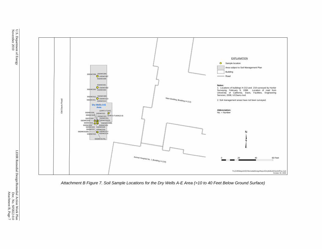
U.S. D
epartment of Energy
LEH
R R
emedial D
esign/Rem
edial Action W
ork Plan N
ovember 2010
D
oc. No. S05822-0.0
Attachm
ent B, Page 7
LEHR-S-T1A04(12.0)
LEHR-S-T1A07
SSDWC001
SSDWC002SSDWC003 SSDWC004
SSDWC005SSDWC006SSDWC007
SSDWC008
SSDWC009SSDWC010
SSDWC011
SSDWC012
SSDWC013
SSDWC014SSDWC015
SSDWC015DLSSDWC016
SSDWC017
SSDWC017DL
SSDWC018SSDWC020
SSDWC021
SSDWC024
SSDWC025SSDWC026
SSDWC028
SSDWC029SSDWC030
SSDWC031SSDWC031DL
SSDWC032
SSDWC033
SSDWC033DL
SSSTC007
EXPLANATION
Sample location
Area subject to Soil Management Plan
Building
Road
T:\LEHR\Maps\DOE\RemedialDesignReport\DryWellsAE\Soil10Plus.mxdOctober 30, 2009
0 20 40 60 Feet
Old
Dav
is R
oad
Notes:1. Locations of buildings H-213 and -219 surveyed by HunterSurveying, February 9, 1998. Location of road fromUniversity of California, Davis, Facilities, EngineeringServices, 2008, UCDavis.mxd.
2. Soil management areas have not been surveyed.
Abbreviation:No. = Number
Dry Wells A-EArea
Main Building (Building H-213)
Animal Hospital No. 1 (Building H-219)
Attachment B Figure 7. Soil Sample Locations for the Dry Wells A-E Area (>10 to 40 Feet Below Ground Surface)
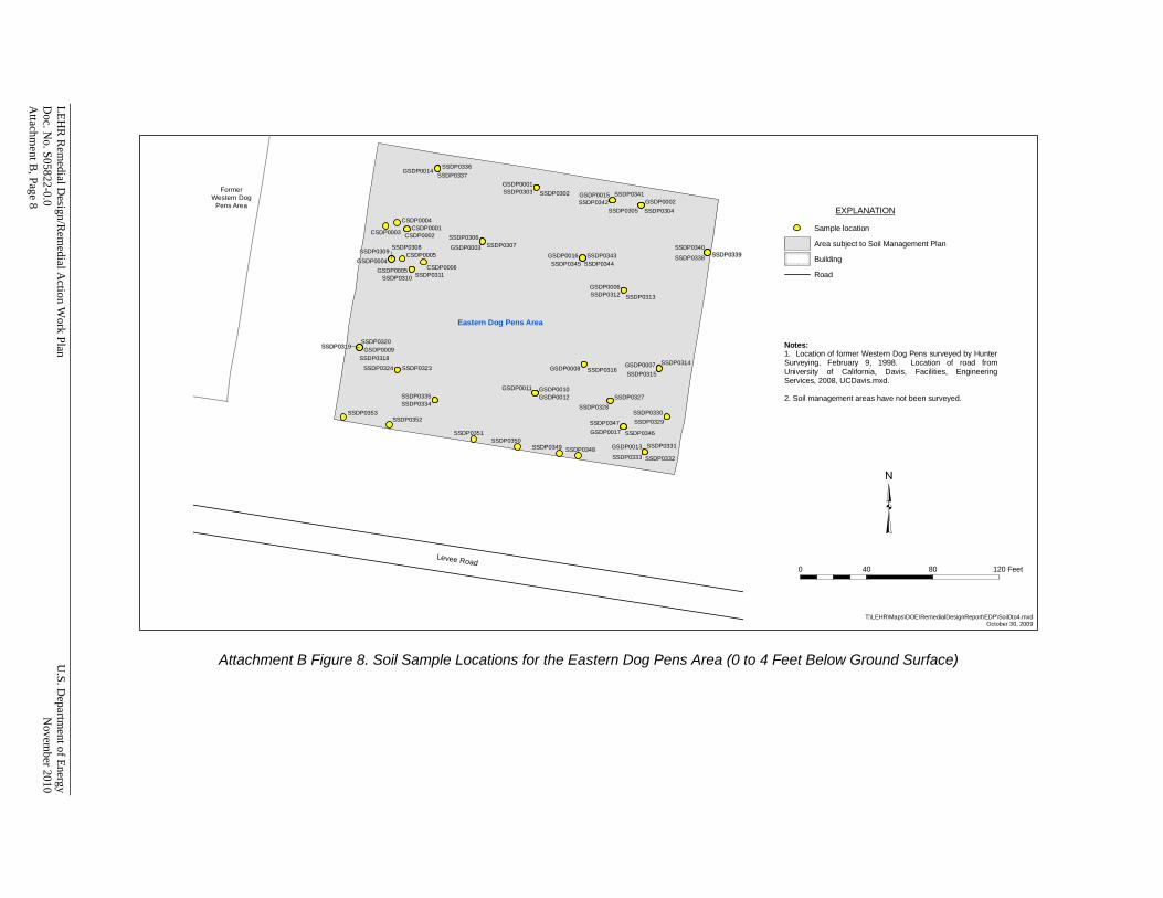
LEHR
Rem
edial Design/R
emedial A
ction Work Plan
U
.S. Departm
ent of Energy D
oc. No. S05822-0.0
N
ovember 2010
Attachm
ent B, Page 8
CSDP0001CSDP0002CSDP0003
CSDP0004
CSDP0005
CSDP0006
GSDP0001
GSDP0002
GSDP0003
GSDP0004GSDP0005
GSDP0006
GSDP0007GSDP0008
GSDP0009
GSDP0010GSDP0011GSDP0012
GSDP0013
GSDP0014
GSDP0015
GSDP0016
GSDP0017
SSDP0302SSDP0303
SSDP0304SSDP0305
SSDP0306SSDP0307SSDP0308
SSDP0309
SSDP0310 SSDP0311
SSDP0312 SSDP0313
SSDP0314
SSDP0315SSDP0316
SSDP0318
SSDP0319SSDP0320
SSDP0323SSDP0324
SSDP0327SSDP0328
SSDP0329SSDP0330
SSDP0331
SSDP0332SSDP0333
SSDP0334SSDP0335
SSDP0336SSDP0337
SSDP0338 SSDP0339SSDP0340
SSDP0341SSDP0342
SSDP0343SSDP0344SSDP0345
SSDP0346
SSDP0347
SSDP0348SSDP0349SSDP0350
SSDP0351
SSDP0352SSDP0353
EXPLANATION
Sample location
Area subject to Soil Management Plan
Building
Road
T:\LEHR\Maps\DOE\RemedialDesignReport\EDP\Soil0to4.mxdOctober 30, 2009
0 40 80 120 FeetLevee Road
Notes:1. Location of former Western Dog Pens surveyed by HunterSurveying, February 9, 1998. Location of road fromUniversity of California, Davis, Facilities, EngineeringServices, 2008, UCDavis.mxd.
2. Soil management areas have not been surveyed.
Eastern Dog Pens Area
FormerWestern Dog
Pens Area
Attachment B Figure 8. Soil Sample Locations for the Eastern Dog Pens Area (0 to 4 Feet Below Ground Surface)

U.S. D
epartment of Energy
LEH
R R
emedial D
esign/Rem
edial Action W
ork Plan N
ovember 2010
D
oc. No. S05822-0.0
Attachm
ent B, Page 9
SSRSC017
SSRSC030
SSRSC026
SSRSC007
SSRSC010
SSRSC029
SSRSC021
SSRSF158
SSRSC052SSRSC051
SSRSC066
SSRSC067
SSRSC064
SSRSC076
SSRSC063
SSRSC078
SSRSC031
SSRSC027
SSRSC011
SSRSC068
SSRSC065
EXPLANATION
Sample location
Area subject to Soil Management Plan
Building
Road
T:\LEHR\Maps\DOE\RemedialDesignReport\RaSr\Soil0To4.mxdOctober 30, 2009
0 30 60 90 Feet
Old
Dav
is R
oad
Notes:1. Locations of buildings H-215, -217, -218, and -219surveyed by Hunter Surveying, February 9, 1998. Location ofbuilding H-216 and road from University of California Davis,Facilities, Engineering Services, 2008, UCDavis.mxd.
2. Soil management areas have not been surveyed.
Abbreviation:No. = Number
Radium/StrontiumTreatment Systems Area
Animal Hospital No. 2 (Building H-218)
Animal Hospital No. 1 (Building H-219)
Clinical Pathology (Building H-215)
Inter-Regional Project No. 4 (Building H-217)
Specimen Storage(Building H-216)
Samplescollected inimported fill:
CWRSC025CWRSC026CWRSC027CWRSC028CWRSC032CWRSC033CWRSC034CWRSC035CWRSC036CWRSC037CWRSC040CWRSC041CWRSC042CWRSC043CWRSC044CWRSC045CWRSC046CWRSC047CWRSC059CWRSC061CWRSC062CWRSC063CWRSC064CWRSC067CWRSC068CWRSC069CWRSC070CWRSC071CWRSC072CWRSC073CWRSC075CWRSC076CWRSC077CWRSC078CWRSC079CWRSC080CWRSC081CWRSC082CWRSC083
Samplescollected inimported fill:
SSRSB001SSRSB002SSRSB003SSRSB004SSRSB005SSRSB006SSRSB007SSRSB008SSRSB009SSRSB010SSRSB011
Attachment B Figure 9. Soil Sample Locations for the Radium/Strontium Treatment Systems Area (0 to 4 Feet Below Ground Surface)

LEHR
Rem
edial Design/R
emedial A
ction Work Plan
U
.S. Departm
ent of Energy D
oc. No. S05822-0.0
N
ovember 2010
Attachm
ent B, Page 10
SSRSC001
SSRSC002
SSRSC003
SSRSC004
SSRSC005SSRSC006
SSRSC008
SSRSC009
SSRSC012
SSRSC015
SSRSC019
SSRSC022
SSRSC024
SSRSC025
SSRSC028
SSRSC032
SSRSC033
SSRSC036
SSRSC037
SSRSC038
SSRSC043
SSRSC044SSRSC045
SSRSC046
SSRSC047
SSRSC048
SSRSC049
SSRSC050
SSRSC053
SSRSC054
SSRSC055
SSRSC057SSRSC058
SSRSC059
SSRSC062
SSRSC069
SSRSC070
SSRSC071
SSRSC072
SSRSC073
SSRSC074
SSRSC075
SSRSC077
SSRSDL04
SSRSDL15
SSRSDL22
SSRSDL55
SSRSF154SSRSF155
SSRSF156
SSRSF159SSRSF160
SSRSF166
SSRSF167SSRSF168SSRSF169
SSRSF172SSRSF180
SSRSF181
SSRSF182SSRSF183
SSRSF184SSRSF185
EXPLANATION
Sample location
Area subject to Soil Management Plan
Building
Road
T:\LEHR\Maps\DOE\RemedialDesignReport\RaSr\Soil4To10.mxdOctober 30, 2009
0 30 60 90 Feet
Old
Dav
is R
oad
Notes:1. Locations of buildings H-215, -217, -218, and -219surveyed by Hunter Surveying, February 9, 1998. Location ofbuilding H-216 and road from University of California Davis,Facilities, Engineering Services, 2008, UCDavis.mxd.
2. Soil management areas have not been surveyed.
Abbreviation:No. = Number
Radium/StrontiumTreatment Systems Area
Animal Hospital No. 2 (Building H-218)
Animal Hospital No. 1 (Building H-219)
Clinical Pathology (Building H-215)
Inter-Regional Project No. 4 (Building H-217)
Specimen Storage(Building H-216)
Attachment B Figure 10. Soil Sample Locations for the Radium/Strontium Treatment Systems Area (>4 to 10 Feet Below Ground Surface)

U.S. D
epartment of Energy
LEH
R R
emedial D
esign/Rem
edial Action W
ork Plan N
ovember 2010
D
oc. No. S05822-0.0
Attachm
ent B, Page 11
SSRSC041
SSRSDL43
SSRSDL44
SSRSDL45
SSRSDL46SSRSDL47
SSRSDL48SSRSDL49
SSRSC018
LEHR-S-454LEHR-S-455LEHR-S-456
LEHR-S-457
SSRSC042
SSRSDL66
SSRSDL67SSRSDL68SSRSDL69
SSRSC040
SSRSDL01SSRSDL02
SSRSDL03SSRSC039
SSRSC035
SSRSDL62SSRSDL63 SSRSDL64
SSRSDL65
SSRSF161SSRSF162
SSRSF163
SSRSF164
SSRSF165
SSRSC014
SSRSC013
SSRSF170
SSRSF171
SSRSC023
SSRSC034
SSRSDL16SSRSDL17SSRSDL18
SSRSDL19SSRSDL20
SSRSDL21
SSRSC020SSRSDL39
SSRSDL40SSRSDL41
SSRSDL42
SSRSC016
SSRSDL05
SSRSDL06
SSRSDL07 SSRSDL08
SSRSDL09
SSRSDL10SSRSDL11
SSRSDL12SSRSDL13
SSRSDL14
SSRSF173SSRSF174SSRSF175
SSRSF176
SSRSF177
LEHR-S-449
LEHR-S-450LEHR-S-451
SSRSC061
SSRSC056
SSRSDL23
SSRSDL24
SSRSDL25
SSRSDL26SSRSDL27SSRSDL28
SSRSC060
SSRSDL33
SSRSDL34SSRSDL35
SSRSDL36
SSRSDL37
SSRSDL38
SSRSDL29SSRSDL30SSRSDL31
SSRSDL32
SSRSDL50
SSRSDL51SSRSDL52SSRSDL53
SSRSDL54
SSRSDL56
SSRSDL57SSRSDL58SSRSDL59
SSRSDL60
SSRSDL61
EXPLANATION
Sample location
Area subject to Soil Management Plan
Building
Road
T:\LEHR\Maps\DOE\RemedialDesignReport\RaSr\Soil10Plus.mxdOctober 30, 2009
0 30 60 90 Feet
Old
Dav
is R
oad
Notes:1. Locations of buildings H-215, -217, -218, and -219surveyed by Hunter Surveying, February 9, 1998. Location ofbuilding H-216 and road from University of California Davis,Facilities, Engineering Services, 2008, UCDavis.mxd.
2. Soil management areas have not been surveyed.
Abbreviation:No. = Number
Radium/StrontiumTreatment Systems Area
Animal Hospital No. 2 (Building H-218)
Animal Hospital No. 1 (Building H-219)
Clinical Pathology (Building H-215)
Inter-Regional Project No. 4 (Building H-217)
Specimen Storage(Building H-216)
Attachment B Figure 11. Soil Sample Locations for the Radium/Strontium Treatment Systems Area (>10 to 47.5 Feet Below Ground Surface)

LEHR
Rem
edial Design/R
emedial A
ction Work Plan
U
.S. Departm
ent of Energy D
oc. No. S05822-0.0
N
ovember 2010
Attachm
ent B, Page 12
LEHR-S-482
LEHR-S-483
LEHR-S-484
LEHR-S-485
LEHR-S-486LEHR-S-487
LEHR-S-488LEHR-S-489 LEHR-S-490
LEHR-S-491
LEHR-S-492
LEHR-S-493
LEHR-S-494
LEHR-S-495
SSDTC001SSDTC002
SSDTC004 SSDTC005SSDTC006
SSDTC007
SSDTC008 SSDTC009
SSDTC011SSDTC012
SSDTC013
SSDTC015
SSDTC016
SSDTC017
SSDTC018
SSDTC019
SSDTC020
SSDTC021 SSDTC022 SSDTC024
SSDTC025
SSDTC026SSDTC027
SSDTC028SSDTC029
SSDTC030
SSDTC031
SSDTC033
SSDTC034
SSDTC037
SSDTC039
SSDTC040
SSDTC049
SSDTC052
SSDTC053
SSDTC057
SSDTC058SSDTC059
SSDTC062
SSDTC068SSDTC069SSDTC070
SSDTC074
SSDTC075
SSDTC086
SSDTC090
SSDTF223
SSDTF225
SSDTF230
SSDTF234
SSDTF238
SSDTF239
SSDTF241
SSDTF242
SSDTF244
SSDTF245
SSDTF248
SSDTF251
SSDTF252
SSDTF258
SSDTF259
SSDTF263
SSDTF268SSDTF269
SSDTF360
SSDTF361
SSDTF362
SSDTF363
SSDTF364
SSDTF365
SSDTF366
SSDTF367
SSDTF368
SSDTF369
SSDTF370
SSDTF592
SSDTF602
SSDTF613
SSDTF624SSDTF635
SSDTF646
SSDTF654
SSDTF662
SSDTF735
SSDTF745
SSDTF755
SSDTF765
SSDTF808
SSDTF819
SSDTF829
SSDTF871
SSDTF881
SSDTF891
SSDTF901SSDTF909
SSDTF910
SSDTF920
SSDTF931
SSDTF941SSDTF952
EXPLANATION
Sample location
Area subject to Soil Management Plan
Building
Road
T:\LEHR\Maps\DOE\RemedialDesignReport\SWT\Soil0To4.mxdOctober 30, 2009
0 30 60 90 Feet
Old
Dav
is R
oad
Notes:1. Locations of buildings H-215, -217, -218, and -219surveyed by Hunter Surveying, February 9, 1998. Location ofbuilding H-216 and roads from University of California, Davis,Facilities, Engineering Services, 2008, UCDavis.mxd.
2. Soil management areas have not been surveyed.
SouthwestTrenches Area
Clinical Pathology (Building H-215)SpecimenStorage(Building H-216)
Levee Road
Attachment B Figure 12. Soil Sample Locations for the Southwest Trenches Area (0 to 4 Feet Below Ground Surface)

U.S. D
epartment of Energy
LEH
R R
emedial D
esign/Rem
edial Action W
ork Plan N
ovember 2010
D
oc. No. S05822-0.0
Attachm
ent B, Page 13
SSDTC032
SSDTC035
SSDTC036SSDTC038 SSDTC041
SSDTC042
SSDTC048
SSDTC050
SSDTC051
SSDTC054
SSDTC055 SSDTC056
SSDTC060SSDTC061
SSDTC063
SSDTC064
SSDTC065
SSDTC066 SSDTC067
SSDTC071SSDTC072
SSDTC073
SSDTC076
SSDTC077 SSDTC079
SSDTC083
SSDTC084
SSDTC087SSDTDL01
SSDTDL06
SSDTDL12
SSDTDL21
SSDTDL30SSDTDL35
SSDTF593SSDTF594
SSDTF603SSDTF604
SSDTF614SSDTF615
SSDTF625SSDTF626
SSDTF627
SSDTF636SSDTF637
SSDTF647
SSDTF648
SSDTF655 SSDTF656SSDTF663
SSDTF664
SSDTF673SSDTF674
SSDTF736
SSDTF737SSDTF746SSDTF747
SSDTF756
SSDTF757
SSDTF766
SSDTF767
SSDTF774
SSDTF809SSDTF810
SSDTF820SSDTF821
SSDTF830SSDTF831
SSDTF840SSDTF841
SSDTF864SSDTF865
SSDTF872SSDTF873
SSDTF882
SSDTF883
SSDTF892
SSDTF893
SSDTF902SSDTF903
SSDTF904SSDTF911SSDTF912
SSDTF921SSDTF922
SSDTF932SSDTF933
SSDTF942SSDTF943
SSDTF953SSDTF954
EXPLANATION
Sample location
Area subject to Soil Management Plan
Building
Road
T:\LEHR\Maps\DOE\RemedialDesignReport\SWT\Soil4To10.mxdOctober 30, 2009
0 30 60 90 Feet
Old
Dav
is R
oad
Notes:1. Locations of buildings H-215, -217, -218, and -219surveyed by Hunter Surveying, February 9, 1998. Location ofbuilding H-216 and roads from University of California, Davis,Facilities, Engineering Services, 2008, UCDavis.mxd.
2. Soil management areas have not been surveyed.
SouthwestTrenches Area
Clinical Pathology (Building H-215)SpecimenStorage(Building H-216)
Levee Road
Attachment B Figure 13. Soil Sample Locations for the Southwest Trenches Area (>4 to 10 Feet Below Ground Surface)

LEHR Remedial Design/Remedial Action Work Plan U.S. Department of Energy Doc. No. S05822-0.0 November 2010 Attachment B, Page 14
LEHR-S-357
LEHR-S-361
LEHR-S-466LEHR-S-467LEHR-S-469
LEHR-S-472LEHR-S-473LEHR-S-474
LEHR-S-477LEHR-S-478LEHR-S-480LEHR-S-481
SSDTC043SSDTC044
SSDTC045
SSDTC046
SSDTC047
SSDTC078
SSDTC080
SSDTC081SSDTC082
SSDTC085
SSDTC088SSDTC089
SSDTDL02SSDTDL03SSDTDL04SSDTDL05
SSDTDL07SSDTDL08SSDTDL09SSDTDL10SSDTDL11
SSDTDL13SSDTDL14SSDTDL15SSDTDL16SSDTDL17SSDTDL18SSDTDL19SSDTDL20
SSDTDL22SSDTDL23SSDTDL24SSDTDL25SSDTDL26SSDTDL27SSDTDL28SSDTDL29
SSDTDL31SSDTDL32SSDTDL33SSDTDL34
SSDTDL36SSDTDL37SSDTDL38SSDTDL39SSDTDL40
SSDTF595SSDTF596SSDTF597SSDTF598SSDTF599SSDTF600SSDTF601
SSDTF605SSDTF606SSDTF607SSDTF608SSDTF609SSDTF610SSDTF611SSDTF612
SSDTF616SSDTF617SSDTF618SSDTF619SSDTF620SSDTF621SSDTF622SSDTF623
SSDTF628SSDTF629SSDTF630SSDTF631SSDTF632SSDTF633SSDTF634
SSDTF638SSDTF639SSDTF640SSDTF641SSDTF642SSDTF643SSDTF644SSDTF645
SSDTF649SSDTF650SSDTF651SSDTF652SSDTF653SSDTF955SSDTF956SSDTF957SSDTF958SSDTF959SSDTF960SSDTF961SSDTF962
SSDTF657SSDTF658SSDTF659SSDTF660SSDTF661
SSDTF665SSDTF666SSDTF667SSDTF668SSDTF669SSDTF670SSDTF671SSDTF672
SSDTF675SSDTF676SSDTF677SSDTF678SSDTF679SSDTF680SSDTF681
SSDTF682SSDTF683SSDTF684SSDTF685SSDTF686SSDTF687SSDTF688SSDTF689
SSDTF690SSDTF691SSDTF692SSDTF693SSDTF694SSDTF695SSDTF696
SSDTF697SSDTF698SSDTF699SSDTF700SSDTF701SSDTF702SSDTF703SSDTF704
SSDTF705SSDTF706SSDTF707SSDTF708SSDTF709SSDTF710SSDTF711SSDTF712
SSDTF713SSDTF714SSDTF715SSDTF716SSDTF717SSDTF718SSDTF719SSDTF720
SSDTF721SSDTF722SSDTF723SSDTF724SSDTF725SSDTF726SSDTF727
SSDTF728SSDTF729SSDTF730SSDTF731SSDTF732SSDTF733SSDTF734
SSDTF738SSDTF739SSDTF740SSDTF741SSDTF742SSDTF743SSDTF744
SSDTF748SSDTF749SSDTF750SSDTF751SSDTF752SSDTF753SSDTF754
SSDTF758SSDTF759SSDTF760SSDTF761SSDTF762SSDTF763SSDTF764
SSDTF768SSDTF769SSDTF770SSDTF771SSDTF772SSDTF773
SSDTF775SSDTF776SSDTF777SSDTF778SSDTF779SSDTF780SSDTF781
SSDTF782SSDTF783SSDTF784SSDTF785SSDTF786
SSDTF787SSDTF788SSDTF789SSDTF790SSDTF791SSDTF792SSDTF793SSDTF794
SSDTF795SSDTF796SSDTF797SSDTF798SSDTF799SSDTF800SSDTF801
SSDTF802SSDTF803SSDTF804SSDTF805SSDTF806SSDTF807
SSDTF811SSDTF812SSDTF813SSDTF814SSDTF815SSDTF816SSDTF817SSDTF818SSDTF832SSDTF833SSDTF834SSDTF835SSDTF836SSDTF837SSDTF838SSDTF839
SSDTF822SSDTF823SSDTF824SSDTF825SSDTF826SSDTF827SSDTF828
SSDTF842SSDTF843SSDTF844SSDTF845SSDTF846SSDTF847SSDTF848SSDTF849
SSDTF850SSDTF851SSDTF852SSDTF853SSDTF854SSDTF855
SSDTF856SSDTF857SSDTF858SSDTF859SSDTF860SSDTF861SSDTF862SSDTF863
SSDTF866SSDTF867SSDTF868SSDTF869SSDTF870
SSDTF874SSDTF875SSDTF876SSDTF877SSDTF878SSDTF879SSDTF880
SSDTF884SSDTF885SSDTF886SSDTF887SSDTF888SSDTF889SSDTF890
SSDTF894SSDTF895SSDTF896SSDTF897SSDTF898SSDTF899SSDTF900
SSDTF905SSDTF906SSDTF907SSDTF908
SSDTF913SSDTF914SSDTF915SSDTF916SSDTF917SSDTF918SSDTF919
SSDTF923SSDTF924SSDTF925SSDTF926SSDTF927SSDTF928SSDTF929SSDTF930
SSDTF934SSDTF935SSDTF936SSDTF937SSDTF938SSDTF939SSDTF940
SSDTF944SSDTF945SSDTF946SSDTF947SSDTF948SSDTF949SSDTF950SSDTF951
EXPLANATION
Sample location
Area subject to Soil Management Plan
Building
Road
T:\LEHR\Maps\DOE\RemedialDesignReport\SWT\Soil10Plus.mxdNovember 5, 2009
0 20 40 60 Feet
Notes:1. Location of building H-215 surveyed by Hunter Surveying,February 9, 1998. Location of building H-216 and road fromUniversity of California, Davis, Facilities, EngineeringServices, 2008, UCDavis.mxd.
2. Soil management areas have not been surveyed.
SouthwestTrenches Area
Clinical Pathology (Building H-215)
SpecimenStorage(Building H-216)
Levee Road
Attachment B Figure 14. Soil Sample Locations for the Southwest Trenches Area (>10 to 44 Feet Below
Ground Surface)

Attachment C
Analytical Results, Soil Samples Collected in DOE Areas (on CD-ROM)

This page intentionally left blank
Attachment D
Soil Disturbance Permit

This page intentionally left blank

U.S. Department of Energy LEHR Remedial Design/Remedial Action Work Plan November 2010 Doc. No. S05822-0.0 Attachment D, Page 1
PERMIT APPLICATION FOR SOIL DISTURBANCE AT LEHR SUPERFUND SITE
This section to be completed by unit performing work.
Work requested by: Work to be performed by: Schedule: Describe proposed work, or attach documents describing scope: Anticipated depth of soil disturbance:
Map indicating project location(s) and anticipated area(s) of soil disturbance is attached. List project plans submitted with application:
Requestor Signature:
Unit:
Name/Title: Date:

LEHR Remedial Design/Remedial Action Work Plan U.S. Department of Energy Doc. No. S05822-0.0 November 2010 Attachment D, Page 2
PERMIT CONDITIONS This section to be completed by EH&S Unit.
Soil disturbed is in areas not subject to SMP for DOE areas. No SMP conditions apply. STOP HERE.
Work to be performed in areas subject to SMP for DOE areas. Site inspection conducted (date)
Possible to relocate work to avoid soil disturbance in area subject to SMP. Discussed
with project requestor. Describe, and attach site map with alternate location(s):
Requestor agrees to relocate work to area not subject to the SMP. Attach new map showing new project location. STOP HERE.
Project will disturb soil in area(s) subject to the SMP per survey maps and legal
descriptions of DOE areas subject to land-use restrictions. The conditions checked below will be in effect:
All project staff must be trained on aspects of the SMP relevant to their work.
Soil disturbed at 0–10 feet below ground surface will be sampled for constituents in attached table. (attach Table A−1 and indicate sections applicable to area being disturbed.)
Soil disturbed at 0–10 feet below ground surface contaminated above site background may not be reused on site without a risk assessment approved by DTSC and EPA. Soil with contaminant concentrations at or below background will be considered clean and may be reused on site.
Soil disturbed at >10 feet below ground surface will be sampled for constituents determined by professional judgment to be potentially present in the soil in concentrations above site background (source: Attachment C of the SMP).
Soil disturbed at >10 feet below ground surface will not be reused on site without a risk assessment approved by DTSC and EPA if it contains contaminant concentrations above the site background. Soil with contaminant concentrations below background values will be considered clean and may be reused on site.
Non-soil waste (e.g., personal protective equipment) contaminated from contact with site soil must be characterized and managed according to its designation.
The characterization of all waste is the responsibility of the requesting party. Results of any soil scan/sampling/characterization activities associated with this soil
disturbance will be submitted to the EH&S Unit. Provide map of soil excavation, soil reuse locations, volumes of soil reused, and/or
volumes of soil disposed of, and documentation of disposal. Oversight by an environmental professional is required on a/an [frequency] basis.
Inspection by the EH&S Unit to be conducted on a/an [frequency] basis.
If unusual or unexpected conditions are discovered, such as discoloration or unexpected contamination, during this soil disturbance, the project requestor will immediately notify the

U.S. Department of Energy LEHR Remedial Design/Remedial Action Work Plan November 2010 Doc. No. S05822-0.0 Attachment D, Page 3
EH&S Unit. The EH&S Unit will coordinate the notification of DOE and the regulatory agencies concerning the unexpected conditions.
Environmental Professional Review. (List documents reviewed and comments on the project’s compliance with the SMP; the ROD; and all applicable laws, regulations, and standards.)
Signature:
Name/Title: Date:
PERMIT APPROVAL
Project Approved
Project Denied (Explain rationale.)
EH&S Unit Representative Signature:
Name/Title: Date:
Comments on this package are noted below and retained in the file:

LEHR Remedial Design/Remedial Action Work Plan U.S. Department of Energy Doc. No. S05822-0.0 November 2010 Attachment D, Page 4
PERMIT CLOSE OUT
Required Project Documents Received
Missing Documents and Remedy/Date/Responsible Party
EH&S Unit Representative Signature:
Name/Title: Date: