APPENDIX A: REVIEW OF EXISTING PEDESTRIAN AND … and Bicycle Plan... · REVIEW OF EXISTING...
76
CITY OF PHILADELPHIA PEDESTRIAN & BICYCLE PLAN APRIL 2012 APPENDIX A: REVIEW OF EXISTING PEDESTRIAN AND BICYCLE PLANNING STUDIES This appendix provides an overview of previous planning efforts undertaken in and around Philadelphia that are relevant to the Plan. These include city initiatives, plans, studies, internal memos, and other relevant documents. This appendix briefly summarizes each previous plan or study, discusses its relevance to pedestrian and bicycle planning in Philadelphia, and lists specific recommendations when applicable.
Transcript of APPENDIX A: REVIEW OF EXISTING PEDESTRIAN AND … and Bicycle Plan... · REVIEW OF EXISTING...

C I T Y O F P H I L A D E L P H I A P E D E S T R I A N & B I C Y C L E P L A N A P R I L 2 0 1 2
APPENDIX A: REVIEW OF EXISTING PEDESTRIAN AND BICYCLE PLANNING STUDIES
This appendix provides an overview of previous planning efforts undertaken in and around Philadelphia that are relevant to the Plan. These include city initiatives, plans, studies, internal memos, and other relevant documents. This appendix briefly summarizes each previous plan or study, discusses its relevance to pedestrian and bicycle planning in Philadelphia, and lists specific recommendations when applicable.

CONTENTS
WALKING REPORTS AND STUDIES .......................................................................................................................... 1
Walking in Philadelphia ............................................................................................................................................ 1
South of South Walkabilty Plan................................................................................................................................. 1
North Broad Street Pedestrian Crash Study .............................................................................................................. 2
North Broad Street Pedestrian Safety Audit ............................................................................................................. 3
Pedestrian Safety and Mobility: Status and Initiatives ............................................................................................ 3
Neighborhood/Area Plans and Studies .................................................................................................................. 4
New Kensington Riverfront Plan ............................................................................................................................... 4
Parkwood Community Plan ....................................................................................................................................... 5
Urban Design Study for Logan Triangle .................................................................................................................... 5
Improvements to the Bustleton & Cottman Shopping Area ...................................................................................... 6
Ideas for Making the Connection around 30th
Street ................................................................................................ 7
Station Square Planning Study .................................................................................................................................. 7
UPENN Campus Circulation A Study of Multi-Modal Access ..................................................................................... 8
Powelton Village Directions .................................................................................................................................... 10
West Powelton and Saunders Park Neighborhood Plan ......................................................................................... 11
Walnut Hill Transit Oriented Development ............................................................................................................. 12
Walnut Hill Neighborhood Plan .............................................................................................................................. 13
The Centennial District Master Plan ....................................................................................................................... 14
Overbrook Farms Neighborhood Traffic Study ....................................................................................................... 15
Open Space & Greening Plan for the South Philadelphia Target Area .................................................................... 16
Lower Italian Market Revitalization Project Recommendations ............................................................................. 16
Northern Liberties Neighborhood Plan ................................................................................................................... 17
Mt. Airy Neighborhood Plan ................................................................................................................................... 17
Mt. Airy Placemaking & Streetscape Improvement Plan (for Germantown Ave.) .................................................. 18
Logan Square Neighborhood – Parkway Plan ......................................................................................................... 20
Mobilize to Thrive – Chestnut Hill Regional Area Study .......................................................................................... 21
Germantown and Nicetown Transit-Oriented Plan – Executive Summary ............................................................. 22
Managing Success in Center City: Reducing Congestion, Enhancing Public Spaces ................................................ 23
Passyunk Square Village Center Design Recommendations ................................................................................... 23
Center City Parking Policy Evaluation ..................................................................................................................... 24
Bicycling Reports and Studies .............................................................................................................................. 25
Mode Shift: Philadelphia’s Two-Wheeled Revolution in Progress ........................................................................... 25

Greater Philadelphia Bicycle Facts 2008 ................................................................................................................. 25
Bicycling in the Delaware Valley in 2005: Use, Safety, and Demographics ............................................................ 27
City of Philadelphia Bicycle Network Plan, Task 3 – Assessment of Existing Bicycling Conditions ......................... 29
Feedback on Philadelphia’s Application for a Bicycle-Friendly Community Designation ........................................ 29
Adopt-a-Rack Program ........................................................................................................................................... 30
Bicycle Parking: Key to a Green Philadelphia ......................................................................................................... 31
Bicycling Advisory Task Force Report ...................................................................................................................... 32
Shared-Use Trail Plans and Studies ...................................................................................................................... 33
North Delaware Riverfront Greenway Design Guidelines ....................................................................................... 33
North Delaware Greenway Gaps Feasibility Study ................................................................................................. 34
Tacony Creek Park Trail ........................................................................................................................................... 36
Frankford Greenway Master Plan ........................................................................................................................... 38
Port Richmond Trail ................................................................................................................................................ 39
Lardner’s Point Park ................................................................................................................................................ 40
Poquessing Creek Park Trail Improvements ............................................................................................................ 40
East Coast Greenway Alignment Alternatives Study ............................................................................................... 41
Improving Pedestrian and Bicycle Access to the John Heinz National Wildlife Refuge Clean Air Council (October, 2007) .................................................................................................................................................. 42
The Cobbs Creek Connector Trail from 70th St to the John Heinz National Wildlife Refuge ................................... 43
Trail Development Study for the Tinicum-Fort Mifflin Trail .................................................................................... 44
58th Street Greenway ............................................................................................................................................. 44
Schuylkill River Trail planning efforts ...................................................................................................................... 45
East Coast Greenway East/West Connectivity Study .............................................................................................. 49
Cresheim Trail Feasibility Study .............................................................................................................................. 49
Corridor Plans and Studies ................................................................................................................................... 50
Frankford Avenue Corridor TOD .............................................................................................................................. 50
North Delaware Riverfront Rail Stations Urban Design Study ................................................................................ 51
Roosevelt Boulevard Corridor Transportation Investment Study ............................................................................ 53
Cheltenham Avenue: A Plan for Bridging the Communities, Phase I ...................................................................... 54
Cheltenham Avenue, Phase III: Related Neighborhood Commercial Centers ......................................................... 55
Central Delaware Waterfront Master Plan ............................................................................................................. 55
Baltimore Avenue Community Corridor Design Study ............................................................................................ 56
US 30 Corridor Study (Draft) ................................................................................................................................... 57
City Avenue Access Management ........................................................................................................................... 58
Taming Traffic (Parkside Avenue) ........................................................................................................................... 58

West Market Street Corridor TOD ........................................................................................................................... 59
North Broad Street Transportation and Access Study............................................................................................. 61
Benjamin Franklin Parkway Circulation, Parking, and Transit Study ...................................................................... 62
Ridge Avenue Gateway Plan ................................................................................................................................... 63
Vine Street: Reconnecting Communities ................................................................................................................. 63
DVRPC Road Safety Audit Reports .......................................................................................................................... 64
Other Sources of Information .............................................................................................................................. 65
Increasing Intermodal Access to Transit: Fox Chase ............................................................................................... 65
Increasing Intermodal Access to Transit: Eastwick ................................................................................................. 66
Congestion and Crash Site Analysis Program: 58th Street, Baltimore Ave and Cobbs Creek Parkway ................... 66
Philadelphia Zoo Intermodal Transportation Project .............................................................................................. 67
Pennsylvania Act 209 Transportation Impact Fee Study: Roadway Sufficiency Analysis Report ............................ 68
GreenPlan Philadelphia ........................................................................................................................................... 68
Local Action Plan for Climate Change ..................................................................................................................... 69
Fairmount Park Strategic Plan ................................................................................................................................ 70
Center City Reports: Retaining College Graduates .................................................................................................. 70
Increasing Intermodal Access to Transit – Phases III and IV ................................................................................... 71
Planning Philadelphia’s Open Spaces: Pilot Study Findings and Recommendations for a Citywide Open Space Plan ................................................................................................................................................................................ 71

A PPEN D I X A | REV I EW O F EX I ST I N G PED EST RI A N A N D B I C Y C L E PL A N N I N G ST U D I ES PA G E 1
WALKING REPORTS AND STUDIES
Walking in Philadelphia Philadelphia City Planning Commission (Draft, completed June 2006)
Summary
This document outlines the reasons why walking is an important mode of travel in the city,
including attraction of tourists, residents’ health and well-being, and mobility for the young and
the elderly. It discusses the current walking conditions and problem areas such as uncontrolled
crosswalks, excessive traffic speed, and crowding on sidewalks, and lays out goals,
recommendations, and next steps for the city to improve its walkability. Generally,
Philadelphia’s downtown is one of the most walkable in the United States, with 17,000
downtown residents walking to work on a daily basis. Recommendations include increased
enforcement of traffic laws, better integration of land use and transportation decisions, and
filling gaps in the city’s sidewalk network.
Relevance to the new plan
The document identifies many “pedestrian-friendly design principles” that will need to be
addressed by the plan. Some of these principles include:
Ensure adequate clear width on sidewalks and other walkways.
Use buffers such as curb parking, tree lawns, and bike racks to separate pedestrians
from motor vehicle traffic.
Plan sidewalks (especially in the urban core) by delineating unique zones, such as the
furnishings zone, pedestrian zone, and the frontage/building zone.
Create safer road crossings, by making them visible, short, and signalized
South of South Walkabilty Plan Philadelphia City Planning Commission (Draft December 2008)
Summary The South of South Walkability Plan recognizes the value of walking as a mode of transportation and proposes ways to improve conditions for the pedestrians in the South of South neighborhood in Philadelphia. The study area, bounded by South Street, Broad Street, Washington Avenue, and the Schuylkill River, has seen significant redevelopment in the last decade. The hope is that through targeted public investment in projects to improve walkability, the neighborhood can build on its assets while mitigating existing problems. Further, with the “Six C’s” serving as a framework (Connected, Convenient, Conspicuous and safe, Convivial, Comfortable, and Consistent), this plan will guide comprehensive design improvements to enhance pedestrian safety, traffic flow, storm water systems, and neighborhood aesthetics along several key corridors in the study area.

A PPEN D I X A | REV I EW O F EX I ST I N G PED EST RI A N A N D B I C Y C L E PL A N N I N G ST U D I ES PA G E 2
Relevance to the new plan The South of South Walkability Plan serves as a local-level example for the city-wide Philadelphia Pedestrian and Bicycle Plan. Specific facility recommendations are outlined below.
Facility Recommendations
o To improve connectedness and convenience near the 19th Street and Washington Avenue intersection, this plan recommends bulb-outs with greenery, decorative crosswalks, regularly-spaced streetlights and street trees, back-in angled parking, and adding color to the bicycle lanes.
o To make the intersection of 22nd St. and Christian St. safer and more conspicuous, the plan recommends the installation of a raised intersection with decorative crosswalks and pedestrian-level lighting.
o A raised crosswalk is proposed at the entrance to the schoolyard at C.A. Arthur Elementary School, as this block was found to have above-average traffic speeds.
o Bulb-outs with greenery, street furniture, stormwater runoff management techniques, street lights and street trees were recommended at other locations including the streets alongside E.M. Stanton Elementary School and Universal Institute Charter School, as well as the intersection of Fitzwater and 18th Streets and the 2000 block of Kimball Street.
North Broad Street Pedestrian Crash Study Delaware Valley Regional Planning Commission (May 2008)
Summary This report presents a descriptive analysis of 210 pedestrian-involved motor vehicle crashes that occurred in priority pedestrian crash clusters along or intersecting a four-mile-long segment of North Broad Street between Diamond and Nedro streets in the City of Philadelphia from 2000 to 2006. This represents the largest concentration of such crashes in the Pennsylvania state highway system during this period.
Relevance to the new plan The study provided tabulations for crashes by pedestrian crash type and group, age of pedestrian and driver, time of day (see below) and day of the week in which crashes occurred, and roadway illumination levels. Another valuable element of this study is its discussion of nine priority pedestrian cluster locations found along North Broad Street. These cluster locations are situated around six SEPTA rail stations (from North Philadelphia station to Olney station) that generate an extremely high volume of pedestrian traffic. For each cluster location, the report provides a detailed discussion of street conditions, surrounding land

A PPEN D I X A | REV I EW O F EX I ST I N G PED EST RI A N A N D B I C Y C L E PL A N N I N G ST U D I ES PA G E 3
uses, and any unusual conditions that could contribute to pedestrian-involved motor vehicle crashes. Forty percent of the crashes occurred when a motorist failed to yield to a pedestrian crossing the street in a marked or unmarked crosswalk. The majority of these crashes took place at night.
North Broad Street Pedestrian Safety Audit Delaware Valley Regional Planning Commission (February 2009)
Summary This report serves as the follow-up to DVRPC’s North Broad Street Pedestrian Crash Study, released in May 2008. The report presents findings from a pedestrian safety audit conducted on a four-mile segment of North Broad Street between Lehigh Avenue and Old York Road in Philadelphia. The audit consists of three key objectives: to ascertain possible causes for pedestrian–vehicle conflicts, identify problem locations, and determine improvement recommendations. Due to the similarity of roadway conditions, crash patterns, and land use along the corridor, consistent issues were found which warrant common solutions that will improve the overall pedestrian environment. Relevance to the new plan The audit report provides a balance of engineering- and enforcement-based recommendations, and the recommendations are further balanced based on difficulty, implementation timeframe, and cost of implementation. This organization of the recommendations may prove useful as recommendations are developed for the upcoming Philadelphia Pedestrian and Bicycle Plan.
Facility Recommendations Shorter-term
- Striping and restriping all missing or faded crosswalks, bike lanes, and shoulders. - Ensure walk signal phases are of sufficient length. - Install pedestrian signals that provide dedicated right-of-way to pedestrians. - Include the provision of refuge islands at intersections with excessive crossing widths
and/ or high pedestrian volumes. - Sidewalk and curb repair should be given more attention along the entire corridor.
Medium-term
- Install new mid-block crossing locations - Reduce excessively wide lanes - Reconfigure or adjust signalization at skewed intersections
Pedestrian Safety and Mobility: Status and Initiatives Memo from Deborah Schaaf, addressed to the Bicycle/Pedestrian Advisory Task Force (November 2007)
Summary Current as of the fall of 2007, this document summarizes the ongoing campaigns and initiatives in Philadelphia intended to make walking in the city more safe and enjoyable. It discusses the significance of pedestrian deaths as a percentage of deaths overall in city traffic (~33%), and then mentions some efforts undertaken to combat this problem. The Roosevelt Boulevard

A PPEN D I X A | REV I EW O F EX I ST I N G PED EST RI A N A N D B I C Y C L E PL A N N I N G ST U D I ES PA G E 4
Safety Task Force, the School Safety Zone Task Force, DVRPC’s Regional Safety Task Force, the Streets Department’s “Drive CarePhilly” campaign, and the PhillyWalks advocacy organization are all poised to help support infrastructure improvements and new programs that will make walking more safe and convenient in Philadelphia.
Relevance to the new plan The memorandum provides a good overview of what resources are in place to help improve conditions for pedestrians in Philadelphia.
NEIGHBORHOOD/AREA PLANS AND STUDIES
New Kensington Riverfront Plan New Kensington CDC (February 2008)
Summary This plan provides a large scale vision and specific conceptual plans for the street and open space network in New Kensington, the former industrial district on the Delaware River. It builds off of work done for the Civic Vision for the Central Delaware. The plan offers a vision for balancing development and open space in a way that takes advantage of the natural resources and reflects traditional Philadelphia urban form. Relevance to the new plan The open space plan and street network emphasize waterfront access, neighborhood connectivity, and minimizing the impact of I-95 on pedestrians. The plan extends the grid network to the waterfront and identifies primary and secondary streets for access purposes. The plan also proposes transforming several key streets into “green streets” with extensive landscaping, additional pedestrian amenities and extensive stormwater management infrastructure.

A PPEN D I X A | REV I EW O F EX I ST I N G PED EST RI A N A N D B I C Y C L E PL A N N I N G ST U D I ES PA G E 5
Facility Recommendations include:
Frankford Avenue: A “green street” and a bicycle corridor.
Columbia Avenue: Raised crosswalks at intersecting side streets.
Lehigh Avenue: A park-like street with separated bike lanes and a heavily landscaped median.
Allegheny Avenue: On-street bike lanes plus a 12’-wide shared-use sidepath.
Delaware Avenue: On-street bike lanes plus shared-use path on river side.
Parkwood Community Plan Philadelphia City Planning Commission (2006)
Summary Parkwood was developed as a planned community in the 1950s. The Planning Commission worked with the community to create a roadmap for future improvements to improve the quality of life in the neighborhood. The planning process developed recommendations for streetscape, open space, housing, economic development, civic engagement, arts and culture and quality of life (crime, cleanliness, etc.). Relevance to the new plan As part of the streetscape recommendations, the plan focuses on sidewalk conditions, traffic calming and aesthetic improvements. The Commission notes that, in Pennsylvania, property owners are responsible for repairing and replacing sidewalks, although they are in the public right of way. There are, however, missing sidewalks that are the City’s responsibility, such as at Junod Playground. Facility Recommendations: Create continuous parkland and a trail along the Poquessing Creek, through the neighborhood to the Bucks County border, and connected to the East Coast Greenway. Establish a trail at Byberry Industrial Park, with connections to neighborhood parks, Benjamin Rush State Park, and the proposed Poquessing Trail.
Build new sidewalks and replace sidewalks where needed, especially near Dunks Ferry and Mechanicsville Roads.
Recommended streetscape improvements include bump-outs, medians, adding benches at bus stops, tree planting, and lighting.
Urban Design Study for Logan Triangle Philadelphia City Planning Commission (Draft, December 2009)
Summary This study makes urban design recommendations following the goals established in the Logan Triangle Technical Assistance Program report published by the Urban Land Institute in September 2009. It provides a two phase framework for transforming the neighborhood brownfield adjacent to Route 1 into a ‘green interim’ use. It utilizes green infrastructure as highlighted in the Greenworks Plan for Philadelphia to create interim uses for vacant lots on which more traditional redevelopment might not occur for years.

A PPEN D I X A | REV I EW O F EX I ST I N G PED EST RI A N A N D B I C Y C L E PL A N N I N G ST U D I ES PA G E 6
Relevance to new plan The study proposes eliminating many of the streets which extend from the residential neighborhood in order to create more developable sites and reduce impervious surfaces. The remaining through streets, Wyoming and 9th Street, will be upgraded to provide attractive, tree-shaded pedestrian connections. Facility Recommendations: Wyoming and 9th Streets will continue to be the primary streets through the Logan Triangle for vehicles, pedestrians and SEPTA service.
Improvements to the Bustleton & Cottman Shopping Area Philadelphia City Planning Commission (2004)
Summary The Planning Commission conducted an urban design study of the shopping area around the intersection of Bustleton and Cottman Avenues in Near Northeast Philadelphia. This area includes the Roosevelt Mall and abuts Roosevelt Boulevard on the east. The goals of the study were to strengthen the identity of the shopping area by creating an inviting and memorable place; to enhance the quality of life for neighborhood residents as well as shoppers; and to increase safety and security. Relevance to the new plan Currently the shopping area is heavily auto-dominated, but it is located in a fairly dense residential community. The study recommends improvements to make the shopping area more welcoming to people arriving on foot or by bus. Facility Recommendations:
- Install bollards to keep trucks off the sidewalk. - Establish a plan of pedestrian pathways and sidewalks for internal pedestrian
circulation. - Provide additional crossing opportunities on Cottman Avenue between Roosevelt
Boulevard and Castor Avenue. - Provide buffering between pedestrian zones and auto zones along Cottman Avenue
sidewalks. - Add bike racks.

A PPEN D I X A | REV I EW O F EX I ST I N G PED EST RI A N A N D B I C Y C L E PL A N N I N G ST U D I ES PA G E 7
Ideas for Making the Connection around 30th Street Philadelphia City Planning Commission (Draft April 2010)
Summary Produced by the Urban Design Division of the Philadelphia City Planning Commission, this review is a collection of ideas and options for the streets around the 30th Station, in particular, making connections to the nearby universities and related development..
Relevance for the new plan The review presents potential roadway profiles for 30th Street, 31st Street, JFK Boulevard and Market Street. Market and JFK west of 20th Street were left unresolved in Phase 1 of the Pedestrian and Bicycle Plan. Facility Recommendations include:
- Sidewalk widening and streetscape improvements for Schuylkill Avenue Esplanade from Market to Walnut.
- Vertical connections for bikes and pedestrians at 31st street
- A pedestrian promenade and busway on JFK Street
- Cycletrack or two-way bike path on 30th Street from Market to Walnut
Station Square Planning Study Philadelphia City Planning Commission (Completed June 2008)
Summary This study provides a vision for a new, grand “public outdoor room” between the 30th Street Station and the Old Post Office, now converted to the new IRS office. The2900 block of Market Street is a critical connection between Center City and West Philadelphia. The public realm between the two historic buildings is currently dominated by parking and loading. The study notes that “recent increased security at 30th Station . . . creates a sense of disarray for both pedestrians and vehicular traffic.” Station Square is also adjacent to new and planned development including the Cira Center, IRS, and Cira Center South. Relevance to the new plan
One of the goals of the project is to provide a pedestrian connection between West Philadelphia and the Schuylkill River Trail. The design proposed in the 2008 study has been superseded, but partial implementation of its objectives is underway with a revised design, shown above, through projects on both sides of Market Street.

A PPEN D I X A | REV I EW O F EX I ST I N G PED EST RI A N A N D B I C Y C L E PL A N N I N G ST U D I ES PA G E 8
Facility Recommendations:
Reclaim areas devoted to parking and motor vehicle circulation and expand pedestrian accommodation.
Create continuous broad sidewalks to unify the public space and to create a formal gateway and landmark.
UPENN Campus Circulation A Study of Multi-Modal Access UPENN and UPENN Health System, (April 2009)
Summary The purpose of this plan is to propose multi-modal solutions for existing and anticipated traffic congestion as UPenn plans for the construction of 4.3 million square feet of new development in the vicinity. The plan notes that students and faculty have a relatively minor impact on traffic because of their off-peak schedules and mode choice. It notes that it is the 30,000 employees of the universities and hospitals that fuel the congestion in the area. The proposed growth would add to this employee base and some of it will be located near existing “chokepoints.” Because the traffic congestion cannot be solved with road improvements alone, the plan sets a goal of 15% mode shift away from single-occupancy cars. The study topics include vehicular and pedestrian hot-spots, public transit, parking, and bicycling. Relevance to the new plan The study provides extensive existing condition descriptions of key roads, intersections, and problem spots. Among the problems cited were the lack of a convenient bicycle connection from the Schuylkill River Trail to West Philadelphia; pedestrian problem spots at 30th and Market, 34th and Walnut, and 33rd and Chestnut Streets; and gaps in the bike lane network on Walnut, Chestnut and

A PPEN D I X A | REV I EW O F EX I ST I N G PED EST RI A N A N D B I C Y C L E PL A N N I N G ST U D I ES PA G E 9
Spruce, as well as portions of University Ave and Civic Center Boulevard. Recommendations includes intersection design and signal changes, roadway modifications, new bike lanes, pedestrian bridges, transit connections, bike stations, as well as policy changes for parking, bicycling on campus, and the creation of a Transportation Management Association. Some of the circulation modifications call for adding widening roadways, adding double turn lanes and/or lengthening signal cycles to 120 seconds from 60 or 90 seconds.
Facility Recommendations:
Install textured pavement and in-pavement crosswalk flashers at the intersection of 34th and Locust Streets.
Install traffic calming island between northbound traffic lanes at 33rd Street and Smith Walk.
Widen University Avenue by 10 feet at Baltimore/Woodland Avenues.
Increase signal cycle at intersections on University Avenue/38th Street between I-76 Off ramp and Spruce Street to 120 seconds (from 60 or 90 seconds) during peak hours.
Add a pedestrian overpass at Civic Center Boulevard and Health Sciences Drive to reduce traffic delays caused by the pedestrian-activated phase.
Expand the bike network to Market, Chestnut and 32nd Streets.
Enhance bicycle function of Spruce Street.
Install median cut on 38th Street at Sansom Street. Allow 2-way bike travel on Sansom Street.
Explore off-street bike facility behind Franklin Field and Palestra along 32nd Street.
Increase bike parking in clusters near bike dismount zones, rather than at building front doors.
University City District Gateway Study University City District (Fall 2007)
Summary University City has numerous gateways, from neighborhood corridors to regional access points. The steering committee developed specific recommendations for five gateways. The study also provides streetscape and wayfinding guidelines to create an attractive, uniform, and recognizable public environment within the district. Relevance for the new plan The study presents a family of streetscape treatments inspired by some of the historic streets in the District and adjacent neighborhoods. The study proposes that these common elements should be used throughout the district by developers, utilities and city agencies. The guidelines are designed to improve the quality of the pedestrian experience including: pedestrian-scaled lighting, high-quality materials, special wayfinding, and street trees. The steering committee voiced concern with current “Walk Philadelphia” pedestrian wayfinding system and proposed the use of a “fingerpost” model instead.

A PPEN D I X A | REV I EW O F EX I ST I N G PED EST RI A N A N D B I C Y C L E PL A N N I N G ST U D I ES PA G E 10
Facility Recommendations include: - 30th Street Station area should be a grand, civic front door to West Philadelphia - On the 2900 block of Market Street (Station Square): Remove on-street parking;
widen the sidewalks; add planters, pedestrian lighting, bollards, and wayfinding; minimize overhead signs.
- On the 3000 block of Market Street: Add trees in planters; decorative sidewalk edging; Belgian block median; pedestrian-scale lighting, bump-outs; pedestrian refuge island at crosswalk.
- 38th Street & Lancaster Avenue is an important node on Lancaster Avenue’s retail corridor:
- install pedestrian lighting and plant street trees; add bollards to stop sidewalk parking; add bump-outs.
- 38th Street corridor is a gateway for trolley commuters: Create bump-outs; upgrade parking lot edges; provide at-grade cut-throughs for wheelchairs, strollers, and bicyclists on medians at cross streets.
- 40th and Market Streets is one of the liveliest commercial nodes in the District: Add bump-outs and sidewalk amenities; install an information kiosk; install glass awnings at the subway entrances.
- 40th & Baltimore Trolley Portal: Make the geometry of the plaza more formal with raised planting beds to direct pedestrians to safer crossing points; install public art and interpretive signage.
Powelton Village Directions Powelton Village Civic Association (2011)
Summary This neighborhood plan covers the area roughly bounded by Spring Garden Street, Lancaster Avenue, and 32nd Street. Powelton Village, adjacent to Drexel University, is faced with complex “town and gown” issues as the student population grows and the university expands. Relevance to the new plan 34th Street is identified as a barrier to pedestrians because its width and downhill slope encourage speeding. While the neighborhood has several bike lanes, it lacks a northbound bike lane serving the central area. Poor connections to 30th Street Station is noted as an issue. The streetscapes on four corridors are evaluated from a Complete Streets perspective.

A PPEN D I X A | REV I EW O F EX I ST I N G PED EST RI A N A N D B I C Y C L E PL A N N I N G ST U D I ES PA G E 11
Facility Recommendations include:
- Calm traffic on 34th Street with curb extensions or raised crossings between Lancaster Avenue and Spring Garden Street, possibly up to Mantua Avenue.
- Convert the direction of traffic on 34th Street (north of Market) and Spring Garden Street (30th to 34th) to two-way.
- Eliminate No Turn on Red sign at 31st and Spring Garden intersection. - Add bike lanes on 33rd Street and on Market east of 34th Street. - Reconfigure 38th Street between Lancaster Avenue and Chestnut Street, include
addition of landscaped buffer. - Streetscape improvements along JFK Boulevard and Market Street to provide better
connections between the neighborhood and 30th Street Station.
- Extend the West Bank Greenway south of Powelton Avenue to Market Street.
West Powelton and Saunders Park Neighborhood Plan
Delaware Valley Regional Planning Commission (2004)
Summary This plan is a neighborhood strategic plan to build a framework for economic development, housing and transportation improvements. The study area is focused on the neighborhoods between Market Street and Lancaster from 37th Street to 44th Street. Though near Drexel University and the University of Pennsylvania, this area suffers from disinvestment and poor pedestrian environments. Relevance to the new plan The plan includes recommendations to improve the pedestrian environment, particularly along Lancaster Avenue, with its diagonal intersections. Treatments include curb extensions, transit shelters, sidewalk repair and replacement, pedestrian scale lighting, street trees, and new crosswalks. Market and 38th Streets are considered barriers to pedestrian movement. The plan suggests a need for traffic calming on Powelton Avenue between 38th and 40th, and on 42nd Street. Facility Recommendations include:
- Create a plaza with seating at the intersection of 40th Street, Lancaster and Haverford Avenue.
- Curb extensions along Lancaster Avenue, 42nd Street (south of Haverford Avenue), 40th Street, and Powelton Avenue.

A PPEN D I X A | REV I EW O F EX I ST I N G PED EST RI A N A N D B I C Y C L E PL A N N I N G ST U D I ES PA G E 12
- Install a pedestrian signal at 38th Street and Powelton. - Institute a road diet on 38th Street and create a landscaped median similar to the one on
Spring Garden Street. - Convert Haverford and Spring Garden Streets to two-way operation to reduce speeding
and improve neighborhood connections. - Create a pedestrian route through the Presbyterian Hospital campus to connect
Saunders Park to Market Street at approximately 39th Street.
Walnut Hill Transit Oriented Development Philadelphia City Planning Commission, Walnut Hill Neighborhood Coordination Strategy Team (2009)
Summary The 46th Street El station in Walnut Hill is newly reconstructed but the land-uses in the vicinity of the station are predominately low-density and car-oriented. Underutilized and formerly industrial properties adjacent to a high-speed transit stop have the potential to be transformed into modern, dense mixed-use development.
Relevance to the new plan The planning memo suggests that TOD principles should be incorporated during redevelopment to create a walkable neighborhood center with pedestrian-friendly urban design. The memo recommends using funds recaptured from a proposed Transit Revitalization District to make improvements to the streetscape and public realm.
Facility Recommendations:
- Streetscape improvements on 46th and Farragut Streets between Market and Walnut Streets include curb extensions, sidewalk maintenance, pedestrian lighting, and pedestrian amenities.

A PPEN D I X A | REV I EW O F EX I ST I N G PED EST RI A N A N D B I C Y C L E PL A N N I N G ST U D I ES PA G E 13
- Provide wayfinding for the 46th Street Station. Include real-time information on transit arrivals.
Walnut Hill Neighborhood Plan Walnut Hill Community Association, The Enterprise Center CDC, and 572stakeholders (2007)
Summary The Walnut Hill Neighborhood Plan was holistic and comprehensive in its approach. The objectives of the plan are to preserve and revitalize the Walnut Hill Neighborhood and to “ensure that Walnut Hill remains a safe, vibrant, multi-ethnic, multi-generational neighborhood.” The plan identifies assets, examines challenges and develops priorities and recommendations for housing, neighborhood building, children and families, and economic development. Relevance to the new plan Two major concerns identified in the transportation section of the plan are speeding traffic on Chestnut and Walnut Streets and unattractive pedestrian links to the 46th Street Station from the south, particularly 46th and Farragut Streets. Vacant lots and deteriorated sidewalks discourage people from travelling to and from the El station or shopping on Market Street.
Facility Recommendations:
- Implement traffic calming and streetscape improvements on Chestnut and Walnut Streets, including sidewalk improvements, consistent street tree planting, bump-outs,

A PPEN D I X A | REV I EW O F EX I ST I N G PED EST RI A N A N D B I C Y C L E PL A N N I N G ST U D I ES PA G E 14
new street lights and bus shelters, and screening of parking lots. Reduce Chestnut Street to two travel lanes (like Walnut Street) and install a bike lane.
- Invest in streetscape improvements for key north-south connector streets: 48th, Farragut, and 46th Streets. These streets will receive sidewalk repair, tree pruning and installation, pedestrian lighting, and screening of parking lots.
The Centennial District Master Plan Fairmount Park Conservancy (2005)
Summary The purpose of the master plan is to provide a vision for improving access to and throughout the District in coordination with planned institutional investments in the District. The master plan outlines $100 million in infrastructure projects over the next 20 years that will augment and help to unify $200 million in public and private investments in the institutions. Relevance to the new plan The master plan proposes simplifying and consolidating vehicular access in the District while increasing alternative transportation. The plan also looks at upgrading neighborhood connections across barriers such as I-76, Girard and Parkside Avenues, and regional railroad lines.. Facility Recommendations:
- Create a 5K recreational loop to unify the district. Include new ped/bike bridges over roads to achieve an uninterrupted loop. (This loop is complete as of 2009 and known as the Centennial Loop Trail.)
- Provide a new transit line from 52nd Street and Lancaster, through the park to Center City.
- Improve wayfinding signage to park amenities for all modes. - Rebuild Parkside Avenue and introduce traffic calming and streetscape improvements. - Add new controlled pedestrian crossings of Parkside and Girard Avenues between 38th
and 52nd Streets. - Enhance Girard Avenue bridge with pedestrian improvements including viewing
platforms and a new stair connection to the Kelly Drive path.

A PPEN D I X A | REV I EW O F EX I ST I N G PED EST RI A N A N D B I C Y C L E PL A N N I N G ST U D I ES PA G E 15
Overbrook Farms Neighborhood Traffic Study The Overbrook Farms Club (2010)
Summary This neighborhood-sponsored study focuses on traffic calming and parking issues in the area bounded by City Avenue, Woodbine Avenue, Cardinal Avenue, and 66th Street. Relevance to the new plan The study includes many recommendations to reduce traffic speed and discourage cut-through traffic generated by congestion on City Avenue.
Facility Recommendations:
- Install bumpouts at many intersections along Overbrook Avenue, Sherwood Road, Drexel Road, and Woodbine Avenue.
- Add median islands to Overbrook and Woodbine Avenues, and 66th Street. - Reconfigure three-way intersection of Woodbine Avenue, Lancaster Avenue, and 63rd
Street. - Road diet on 63rd Street to provide at least one bike lane. - Consider directional changes on Overbrook Avenue and Upland Way. - Provide bike parking at Overbrook train station. - Close 64th Street at City Avenue. - Consider diagonal diverters within study area to reduce cut-through traffic.

A PPEN D I X A | REV I EW O F EX I ST I N G PED EST RI A N A N D B I C Y C L E PL A N N I N G ST U D I ES PA G E 16
Open Space & Greening Plan for the South Philadelphia Target Area Pennsylvania Horticultural Society’s Philadelphia Green Program (July 2006)
Summary This plan is a comprehensive vision and strategy for open space within a large portion of South Philadelphia. Bridging many distinct neighborhoods, the study area is faced with many challenges including increasing development impacts, strains on existing infrastructure, physical barriers, vacant and underutilized land, poor play space for schools, limited park space and street trees and, underutilized existing parks that are physically removed from the surrounding context. The recommendations are intended to improve local greening efforts and range from cost-effective improvements for homeowners to larger initiatives that concentrate greening investment in order to have a measurable and visible impact. The plan also includes guidelines for streetscape plantings and improvements as well as detailed design approaches for five ‘focal areas’ that were determined through a comprehensive analysis of the area. Relevance to the new plan The Open Space and Greening Plan recommends that the city improve pedestrian linkages between open space, schools, activity centers, and community institutions. It also echoes several other documents in this memorandum by recommending improved access to the Schuylkill River waterfront. The plan purports that additional gateways are needed to link adjacent neighborhoods to the water’s edge.
Lower Italian Market Revitalization Project Recommendations Passyunk Square Civic Association (August 2008)
Summary Lower Italian Market is seeing an influx of new residents, rising home prices, and a spike in development around 9th Street. In response, the Passyunk Square Civic Association (PSCA) has created a community-driven plan intended to embrace the neighborhood’s own evolving character, and to develop it as a place at once grounded in but also distinct from the traditional Market neighborhood. Relevance to the new plan The report notes as a key issue the fact the Italian Market’s pedestrian’s “slow-speed” experience is endangered by the neighborhood’s increasing auto-centricity. Some features that make Lower Italian Market unwelcoming to pedestrians include deteriorated crosswalks, lighting, and signage, as well as a lack of street furniture. The authors would like to lessen the perceived physical boundary created by Washington Avenue and promote travel to and from the corridor by bicycle and foot.
Facility Recommendations
- Introduce a green median along Washington Avenue near 9th Street, in order to create a visual break and a pedestrian refuge in the mid-point of the vast cartway; further, this will help to “shrink” Washington Avenue, at least in appearance.
- Constrict vehicular traffic flow near the 9th Street and Washington Avenue intersection, to slow speeds and encourage pedestrian and bicycle activity

A PPEN D I X A | REV I EW O F EX I ST I N G PED EST RI A N A N D B I C Y C L E PL A N N I N G ST U D I ES PA G E 17
- Replace one or two on-street vehicle parking spaces with bicycle parking (along East Passyunk Avenue and 9th Street)
Northern Liberties Neighborhood Plan Northern Liberties Neighbors Association (November 2005)
Summary With a focus on proactively influencing and guiding the physical, social, and economic change occurring in Northern Liberties, the Northern Liberties Neighbors Association’s (NLNA) plan provides seven key recommendations including a “Green” philosophy, a seamless transition between the traditional neighborhood fabric and the developing waterfront, and re-establishing 2nd Street as the heart of the neighborhood. Relevance to the new plan The Northern Liberties Neighborhood Plan addresses the fact that while the neighborhood is walkable and bikeable in terms of size and scale, it can still be relatively challenging to navigate due to construction-induced sidewalk blockages, cluttered or missing sidewalks, and a general lack of bicycle parking. Facility Recommendations
- NLNA should include bicycle lanes in their list of streetscape improvements along 2nd, Laurel, Brown Streets and Fairmount Avenue
- All developments that create destinations, residential, commercial, or recreational, should be required to accommodate bicycle storage (the Northern Liberties currently lacks an adequate supply of bicycle racks or lockers for storage)
- Sidewalk repair that accompanies streetscape improvements will facilitate better pedestrian mobility
Mt. Airy Neighborhood Plan Delaware Valley Regional Planning Commission (November 2004)
Summary The Mt. Airy Neighborhood Plan assesses the challenges and opportunities faced by Mt. Airy in the areas of housing, economic development, circulation, and community building, and makes recommendations with an eye toward improving quality of life for residents and visitors. Relevance to the new plan Mt. Airy is first and foremost a walking, biking, and transit-oriented community. With this in mind, the plan asks that all circulation improvements put the pedestrian realm, including sidewalks and crosswalks, first. In keeping with this recommendation, the Philadelphia Pedestrian and Bicycle Plan will consider the needs of pedestrians and bicyclists in Mt. Airy, in order to enhance their experience and improve safety.
Facility Recommendations
- Add new sidewalks, pedestrian-scale lighting, street trees, flowers, and ground covers in the tree pits along Germantown Avenue.

A PPEN D I X A | REV I EW O F EX I ST I N G PED EST RI A N A N D B I C Y C L E PL A N N I N G ST U D I ES PA G E 18
- Improve the pedestrian’s ability to navigate and cross at the intersections of o Phil-Ellena St. and Germantown Avenue o Upsal and Crittenden Sts. o Pelham and Hortter Sts. o Lincoln Drive and Westview St. o Allens Lane and McCallum St.
- Add sidewalks along Wissahickon Avenue where it borders Fairmount Park, especially near streets that lead to the park, such as Westview St. and Kitchens Lane.
- Transform the abandoned rail line that crosses Germantown Ave. between Mt. Airy and Chestnut Hill into a walking/biking trail, which could serve as an entrance to the entire Fairmount Park trail system.
Mt. Airy Placemaking & Streetscape Improvement Plan (for Germantown Ave.) Mt. Airy, USA (April 2008)
Summary The Mt. Airy Placemaking & Streetscape Improvement Plan is designed to support and enhance Germantown Avenue’s recent economic and civic resurgence. The plan lays the groundwork for a series of improvements to the physical infrastructure of the Avenue between Washington Lane and Cresheim Valley Road. The recommendations fall into the categories of Streetscape Elements, Special Projects, Mobility and Traffic, and Navigation and Wayfinding. Relevance to the new plan The chapter on Mobility and Traffic identifies solutions to the circulation problems along the Avenue, namely congestion and conflict between motorists and pedestrians, in order to make the Avenue more safe and appealing. The Streetscape Elements chapter further considers the appeal of the walking environment, by recommending features like pedestrian-scale lighting, street trees, benches, and trash receptacles.
Facility Recommendations - Provide crosswalks at all signalized intersections, with proper pavement markings and
signage. - Mark pedestrian crossings at unsignalized intersections - Install pedestrian signal heads - Create bump-outs at corners with significant pedestrian activity - Create a mid-block crossing on Germantown Avenue, somewhere between the
intersections with Mount Airy Avenue and Mount Pleasant Avenue
Mt. Pleasant Avenue Intersection Project - Present an attractive, identifiable entry into “downtown” Mt. Airy. - Create formal gathering spaces. - Provide amenities such as bus shelters and trash receptacles; incorporate art into bus
shelters. - Replace sidewalk and curb as they “turn the corner” along Mount Pleasant Avenue. - Bring life to the southeast corner with an eatery that features a sidewalk patio.

A PPEN D I X A | REV I EW O F EX I ST I N G PED EST RI A N A N D B I C Y C L E PL A N N I N G ST U D I ES PA G E 19
Mt. Airy Playground Interface Project - Construct a method of access that is attractive, inviting, and that can serve as a small
public space itself. - Create a better transition along the Avenue between “downtown” and Lovett Library to
encourage pedestrian activity to continue down the Avenue.
Chinatown/Callowhill Neighborhood Plan Delaware Valley Regional Planning Commission (November 2004)
Summary Chinatown and Callowhill have the potential to be great walking trip generators, in part due to their proximity and walkability to a multitude of destinations in Center City, including Convention Center and Independence Mall. Some of the challenges include poor pedestrian connections across the Vine Street Expressway, inadequate pedestrian facilities north of Vine Street, high-speed traffic on local streets (especially traffic associated with the Expressway), and a general lack of pedestrian enhancements on major arterials. Relevance to the new plan Through its recommendations, the Chinatown/Callowhill Neighborhood Plan seeks to improve circulation in the area, and it devotes significant attention to making walking a safer and more convenient mode choice. Facility Recommendations
- Extensive traffic calming along the Vine Street local service roads, both north and south of the Expressway (early-action item)
o Reduction in the number of lanes on the north side of the expressway o Reduction in lane widths on both sides of the expressway o Widening of sidewalks o Installation of intensive streetscape enhancements o Installation of curb extensions at all intersections with on-street parking o Installation of highly-visible crosswalks
- Reconnect Franklin Square with Chinatown, especially through pedestrian access o Make entrances to the park more attractive o Restore, and in some places modify, the path system around the park o Institute traffic calming all around the park, and improve pedestrian
connections along Race Street o Transform 6th Street leading from the south to Franklin Square into an urban
boulevard with wide sidewalks and pedestrian amenities. o Create more comfortable and attractive places for pedestrians to cross Vine
Street at the underpass on 6th, 7th, and 8th Streets

A PPEN D I X A | REV I EW O F EX I ST I N G PED EST RI A N A N D B I C Y C L E PL A N N I N G ST U D I ES PA G E 20
Logan Square Neighborhood – Parkway Plan Logan Square Neighborhood Association Philadelphia City Planning Commission (January 2009)
Summary The Logan Square Neighborhood – Parkway Plan (LSNPP) articulates a shared vision for the Logan Square neighborhood, which includes the Benjamin Franklin Parkway.
Relevance to the new plan Planning for pedestrians and cyclists in the Logan Square neighborhood is relevant to the Philadelphia Pedestrian and Bicycle Plan given the surrounding mix of residential, commercial, and institutional uses, the amount of pedestrian traffic generated there, and the potential for conflict between pedestrians, cyclists and motorists. The LSNPP provides many recommendations that directly enhance the pedestrian environment. Pedestrian Facility Recommendations Benjamin Franklin Parkway
- Reduce the “outer” Parkway sections to operate with just one traffic lane during non-peak periods
- Widen the center median islands from 10’ to 20’ for better pedestrian refuges.
- Add bulb-outs and tighten the curb radii along the Parkway (specifically at 21st and 22nd Streets)
- Improve the intersection of 24th Street and Eakins Oval to eliminate the large radius, free-flow right turn onto 24th Street, and create an urban intersection with a crosswalk instead.
Other recommendations
- Add a four-way stop sign at 22nd and Cherry Streets
- Prioritize traffic calming along Callowhill Street and on 22nd Street south of Vine.
- Install a “thin buffer” at the curb where narrow sidewalks are not protected by parallel parking. Bike racks and honor box corrals can serve this purpose well.
- Eliminate free right turn and add a crosswalk at the intersection of 23rd Street and Vine Expressway off-ramp.
- Eliminate the right angle parking on Hamilton Street at 21st in front of the WaWa.
- Install crosswalks at all corners regardless of pedestrian volumes.
- Install pedestrian countdown timers on all crossings wider than three uninterrupted traffic lanes.
- Evaluate the potential for non-peak-period pedestrian-only signals at crucial locations where it is difficult to control the speeds of turning traffic.
Bicycle Facility Recommendations
- Complete the bicycle lanes on 22nd Street as the primary northbound connector.
- Install bicycle lanes on 20th Street south of the Benjamin Franklin Parkway as the primary southbound connector, with 19th Street providing southbound circulation above the Parkway.

A PPEN D I X A | REV I EW O F EX I ST I N G PED EST RI A N A N D B I C Y C L E PL A N N I N G ST U D I ES PA G E 21
- Establish the Pennsylvania Avenue/Callowhill Street corridor as a continuous neighborhood-serving east-west alternative to the Parkway, with Callowhill Street as a shared, heavily-traffic-calmed “destination” zone.
- Correct the existing problematic transitions—primarily along the Parkway—by revisiting their geometric alignments and increasing their visibility.
- Relocate Parkway bike lanes to the outer, traffic-calmed sections of the Parkway.
- Consider the installation of off-street bicycle paths along the north/east edges of Love Park and the northern apron of City Hall Plaza
- Consider a northbound bicycle lane on 16th Street (feeding the Parkway) by eliminating the exclusive right-turn lane to Arch Street.
- Add bicycle parking at Callowhill Street, the Van Colln ball fields, and the Spring Garden subway station.
- Install combined bicycle parking/rental facilities at Race Street/Schuylkill River Park, Logan Square at the Free Library, and JFK Plaza/Love Park.
- Clearly mark (and maintain) specially colored bicycle lanes at all conflict points, i.e. wherever motor vehicles regularly cross the alignment of the bicycle lane.
Mobilize to Thrive – Chestnut Hill Regional Area Study Delaware Valley Regional Planning Commission (Draft – November 2008)
Summary Mobilize to Thrive takes a comprehensive look at the existing transportation conditions in the Chestnut Hill region. To enhance mobility, as well as economic viability, the study recommends enhancing the pedestrian orientation of the region’s main streets and rail station areas. The study suggests improved walkability will encourage local residents to shop locally, allow shoppers driving from elsewhere to “park once, shop twice,” and could grow transit ridership into the region because of the ease in walking from stations and bus stops to close-by destinations. The study also recommends mixed-use reinvestment in the main street areas, and inter-modal transportation linkages throughout the region. Relevance to the new plan In general, the study endorses transportation improvements that allow people to:
- Move around without feeling threatened by excessive traffic speeds and volumes
- Move easily between Germantown, Mt. Airy, and Chestnut Hill and Erdenheim/Flourtown
- Utilize easy and clear pedestrian linkages from transit stations to Germantown Avenue and Bethlehem Pike
Facility Recommendations
- At intersections with low numbers of left turns, identify the opportunities for “bulb-outs” to better accommodate crossing pedestrians. These should be installed in conjunction with high visibility crosswalk markings, and signs notifying motorists to yield to pedestrians.
- Install wayfinding signage along Germantown Avenue.
- Improve the gateway into Springfield Township, especially at the intersection of Bethlehem Pike / Paper Mill Road / Stenton Avenue, by adding sidewalks where they are

A PPEN D I X A | REV I EW O F EX I ST I N G PED EST RI A N A N D B I C Y C L E PL A N N I N G ST U D I ES PA G E 22
missing, installing pedestrian indicators at signals, and upgrading all pavement markings.
- Incorporate traffic calming on Bethlehem Pike near Paper Mill Road, including conversion of the existing through/right turn lane at Stenton and Paper Mill Road to a right turn only lane, installation of a curb extension and striping, and the installation of banners and other placemaking elements in existing median.
Germantown and Nicetown Transit-Oriented Plan – Executive Summary Philadelphia City Planning Commission (Executive Summary –released January 2009)
Summary The Germantown and Nicetown Transit-Oriented Neighborhood Plan takes a comprehensive look at Germantown’s land use patterns, historic resources, recreation, economic development, and quality of life issues. This master plan is the first for Germantown in several years that is comprehensive, municipally endorsed, and reflective of wide community participation. The plan was created to guide and attract public and private investment in Germantown, and area residents, property owners, businesses, developers, and implementing city and state agencies should be able to use the plan to leverage change and direct actions. The plan emphasizes transportation resources as key to community and economic development. As a transit-oriented plan framed around the five train stations in the study area, this plan aims to maximize access to public transportation, revitalize transit stations as centers of activity, and encourage transit ridership. Relevance to the new plan Transit-oriented development (TOD), which promotes transit ridership by concentrating a mix of uses around a transit station, tends to have a greater economic spillover into the surrounding community than does auto-oriented infrastructure and surface parking. Further, because TOD allows transit to fulfill the travel needs of more residents, these residents will almost certainly walk and bicycle more, too. In short, new TOD in the city of Philadelphia will bring more walkers and cyclists into their respective mode shares, and thus will be a key consideration for the recommendations of the Philadelphia Pedestrian and Bicycle Plan.

A PPEN D I X A | REV I EW O F EX I ST I N G PED EST RI A N A N D B I C Y C L E PL A N N I N G ST U D I ES PA G E 23
Managing Success in Center City: Reducing Congestion, Enhancing Public Spaces Center City District/Central Philadelphia Transpo rtation Management Association (February 2008)
Summary Traffic congestion is an impediment to the continued economic vitality of downtown Philadelphia, though ironically, the problem has emerged in part due to past successes in development and business density in the city. The ongoing economic prosperity there should not be stinted; rather, some improvements to the transportation network ought to be made so that transit can move more efficiently, bicyclists can more easily access the area, and pedestrians can get around more safely. The improvements recommended in this report are categorized as short-term, mid-term, and long-term solutions.
Relevance to the new plan The Managing Success report recommends several non-motorized improvements in Center City, including: pedestrian countdown timers at busy crosswalks, enhanced bike lanes, bike boxes at intersections, additional bike parking in the street and in private garages, and all-way pedestrian crossings. Facility Recommendations
- In order to reduce congestion and improve safety at the same time, this study recommends: Continued installation of pedestrian countdown timers in Center City
‘Sharrows’ in travel lane, as well as ‘share the road’ signage alongside the road Painting the intersection box, and placing signs for motorists that say “DON’T BLOCK
THE BOX” (enforce motorist compliance with citations and fines) Enhance bike lane network in Center City
i. Several east/west and north/south streets within the central business district could be designated streets in which bicycles are given greater priority and the space devoted to other modes of transportation is curtailed.
ii. Consider parking-protected bike lanes on 22nd Street and, possibly, on Sansom Street.
Passyunk Square Village Center Design Recommendations Philadelphia City Planning Commission (January 2007)
Summary Passyunk Square, which houses a supermarket and older adult center, is located in a densely populated area in South Philadelphia. With parking lots covering much of the land at the intersection of Reed Street, 10th Street, and Passyunk Avenue, the pedestrian’s sense of streetscape continuity is significantly disrupted. Further, vehicular traffic and non-motorized users tend to conflict with one another. This study seeks to offer remedies through public green spaces, vegetative buffers between vehicular and pedestrian environments, sidewalk trees, historical interpretation, and even the introduction of a new commercial development that would enhance the pedestrian’s sense of streetscape continuity. Through these measures,

A PPEN D I X A | REV I EW O F EX I ST I N G PED EST RI A N A N D B I C Y C L E PL A N N I N G ST U D I ES PA G E 24
Passyunk Avenue can maintain its historical presence as a strong commercial corridor in South Philadelphia.
Relevance to the new plan This South Philadelphia intersection is relevant to the Philadelphia Pedestrian and Bicycle Plan given the surrounding mix of residential, commercial, and institutional uses, the amount of pedestrian traffic generated there, and the documented conflict between pedestrians and motorists. The report provides recommendations that directly enhance the pedestrian environment, and generally add to the urban feel of Passyunk Square.
Center City Parking Policy Evaluation Philadelphia City Planning Commission (July 2005)
Summary Recognizing that there has been a trend from 1980 to 2000 away from transit use and toward single-occupancy vehicle (SOV) commuting into downtown Philadelphia—caused to some extent by an oversupply of off-street parking in Center City (see figure below)—this study’s authors make parking policy recommendations to the Philadelphia City Planning Commission and Philadelphia Parking Authority, so that they might counter this trend. Pricing strategies, improved design of parking facilities, required parking for bicycles, and parking information distribution are among the recommendations made. San Francisco, Arlington, and Chicago serve as case studies. Relevance to the new plan Automobile parking policy is relevant to bicycle and pedestrian planning, in that when parking is widely available and inexpensive, demand for alternative modes is suppressed. Better design

A PPEN D I X A | REV I EW O F EX I ST I N G PED EST RI A N A N D B I C Y C L E PL A N N I N G ST U D I ES PA G E 25
of parking facilities improves the pedestrian environment and makes walking more attractive. The recommendation for required bicycle parking will be fully developed through the Philadelphia Pedestrian and Bicycle Plan.
BICYCLING REPORTS AND STUDIES
Mode Shift: Philadelphia’s Two-Wheeled Revolution in Progress Bicycle Coalition of Greater Philadelphia (2011)
Summary This report summarizes and analyzes data from a variety of sources, all of which demonstrate a significant growth in bicycling in Philadelphia, particularly in the Greater Center City area. Relevance to the new plan The report argues that cyclists are more attracted to streets with better bike facilities, and that such facilities lead to better bicycling behavior. Streets with bike lanes were found to have less sidewalk riding and less wrong-way riding than streets without bike lanes.
Greater Philadelphia Bicycle Facts 2008 Bicycle Coalition of Greater Philadelphia (August 2008)
Summary This concise memorandum lists figures related to the current level of bicycle ridership in the Greater Philadelphia region, the rates of increase in bicycle ridership since the 1990s (as measured at several intercept points), the demographic make-up of cyclists in the city, and a comparison of the bicycle mode to other modes of travel. For example, one striking figure (see below) demonstrates that average hourly numbers of cyclists crossing over the Schuylkill River have steadily increased in years leading up to 2008. The fact sheet later outlines the benefits of riding a bike, the wants and needs of typical cyclists, and the shifts in motorist behavior (as well as conditions for drivers) since the $4/gallon peak in the price of gasoline. Relevance to the new plan The data figures listed in Greater Philadelphia Bicycle Facts 2008 provide a valuable sketch of the demographic make-up of cyclists, it provides many powerful statistics and figures about bicycle ridership levels.

A PPEN D I X A | REV I EW O F EX I ST I N G PED EST RI A N A N D B I C Y C L E PL A N N I N G ST U D I ES PA G E 26
Double Dutch: Bicycling Jumps in Philadelphia
Bicycle Coalition of Greater Philadelphia (Fall 2008)
Summary In fall 2008, the Bicycle Coalition of Greater Philadelphia (BCGP) conducted bicycle counts as part of the Bicycle Ambassadors program. The Bicycle Ambassadors program uses face to face marketing and education to encourage adult bicyclists to ride more safely and follow the rules of the road. The counts conducted by the Ambassadors reported that “bicycling in Philadelphia has increased 300%” since 1990. From 2005 to 2008, the number of bicyclists counted has doubled at all Schuylkill River bridges and at two observed intersections. This report summarizes the findings of the 2008 bicycle counts and compares them to counts conducted in previous years. Relevance to the new plan Double Dutch provides valuable information on bicycling usage patterns in Philadelphia, and as such will inform the development of the Philadelphia Pedestrian and Bicycle Plan.
Bicycle Coalition of Greater Philadelphia

A PPEN D I X A | REV I EW O F EX I ST I N G PED EST RI A N A N D B I C Y C L E PL A N N I N G ST U D I ES PA G E 27
Bicycling in the Delaware Valley in 2005: Use, Safety, and Demographics Delaware Valley Regional Planning Commission (published 2007)
Summary This document describes the results of the 2005 Philadelphia Metropolitan Bicycle Travel Survey, used to create a broad profile sketch of cyclists in the region. While the study area is centered on Philadelphia, it also encompasses counties in southern New Jersey, northern Delaware, and northeastern Maryland. Intercept surveys were conducted with cyclists at locations around the region, and in areas with a variety of development patterns. Cyclists were asked to describe whether their bicycle ride was to work, to school, or just for pleasure, whether they feel safe on the roadways, and what the impediments to cycling are for them. Relevance to the new plan The data rendered by Bicycling in the Delaware Valley provide a valuable sketch of the demographic make-up of cyclists in the greater Philadelphia region. One interesting finding is that “bicyclists choose the bicycle over other modes overwhelmingly for reasons relating to health, pleasure and personal well-being.” (p. 2) Another key finding of the report is that the density of housing and employment in a given area can effectively predict level of bicycle ridership (see figures 27, 29, 31), as well as ease and convenience—or “bikeability”—for cyclists. This finding could help in prioritizing bike facility improvements as part of the network development stage of the plan. Following are additional network-oriented findings included in the report.
o Nearly two thirds of daily bicycle trips are for utilitarian transportation purposes, rather than for exercise or recreation
o Trips where bicycles are carried aboard a train or bus for part of the trip constitute 12 percent of daily bicycle trips
o Bicycle lanes are favored by bicyclists over any other facility type, and over any other action to induce increased ridership; just behind bike lanes in popularity are wide roadway shoulders

A PPEN D I X A | REV I EW O F EX I ST I N G PED EST RI A N A N D B I C Y C L E PL A N N I N G ST U D I ES PA G E 28
Bicycling in the Delaware Valley in 2005 – Selected graphs from the study
Frequency of bike travel at intercept locations during study
month, by area type Note that the frequency of response for “daily or almost daily” declines sharply from CBD/Fringe (47%) across the spectrum to Rural/Open Rural (4%).
Frequency of bicycling to work during study month, by area type The frequency of respondents who bicycle to work daily, almost daily, or 10-20 times per month declines steeply from those in the CBD/Fringe (66%) to those in Rural/Open Rural (5%) parts of the region.
Frequency of bicycling to school during study month, by area type The percentage and frequency of bicyclists commuting to school is relatively small regionally, as compared to those commuting to work. Fewer than one in five has biked to school at least once during the study month. Again, the percentage declines across area types.

A PPEN D I X A | REV I EW O F EX I ST I N G PED EST RI A N A N D B I C Y C L E PL A N N I N G ST U D I ES PA G E 29
City of Philadelphia Bicycle Network Plan, Task 3 – Assessment of Existing Bicycling Conditions City of Philadelphia Streets Department (1997)
Summary The Philadelphia Bicycle Network Plan was intended to promote bicycling both as a mode of transportation and as a recreational activity within the city. The plan identified locations where new facilities were needed to provide better connectivity between common origins and destinations. It also explored programs useful in encouraging cycling, such as education and training, commuting incentives, and enhanced transit access. Task 3, titled “Assessment of Existing Bicycling Conditions” looks at the numerous factors creating latent demand for cycling in the city, as well as the barriers to cycling, such as roadway debris, lack of bike parking, and concern for personal safety.
Relevance to the new plan The intention of the new plan is to identify and help prioritize bicycle infrastructure improvements that will enhance the safety and convenience of bicycling in Philadelphia. The new plan will build upon the work done for the first Bicycle Network plan.
Feedback on Philadelphia’s Application for a Bicycle-Friendly Community Designation League of American Bicyclists (LAB)(2006)
Summary Philadelphia has all the ingredients to become a truly Bicycle-Friendly Community (BCF). There is a supportive city government, an established bike culture, and effective cycling advocates, including 12 local bicycling clubs. Although Philadelphia was not selected as a BCF this year, reviewers hope that this marks a commitment and growing momentum in the community to make improvements in the future. Highlights of the application included the weekend bicycle “parkways,” mountain biking facilities within the city, and the developing network of facilities in the region. Relevance to the new plan The completion of the Philadelphia Pedestrian and Bicycle Plan will satisfy one of the recommendations of the BCF committee. Some of the other recommendations include:
- Continue training for city staff on bicycle facility planning and design. Establish an ongoing training plan.
- Expand motorist education and Share-the-Road encouragement programs by creating informational hand-outs for drivers and cyclists.
- Create secure bicycle parking throughout the community. In addition, enact a regulation requiring inclusion of bike parking in development plans.
- Implement a Safe Routes to School program that includes education and encouragement components to build on the engineering efforts on the ground.
- Plan and deliver a series of Bicycle-Friendly Community workshops for your community.

A PPEN D I X A | REV I EW O F EX I ST I N G PED EST RI A N A N D B I C Y C L E PL A N N I N G ST U D I ES PA G E 30
Bike Lane Survey Philadelphia City Planning Commission (December 2005)
Summary The Philadelphia City Planning Commission conducted an extensive assessment of the City’s bicycle lanes in 2003 and 2004. The purpose of this survey was to determine the overall level of safety, connectivity, and comprehensiveness of the city’s bicycle lane network. Surveyors used the Philadelphia Bicycle Map (issued by the Streets Department) in order to determine the location of bicycle lanes throughout the city. All streets labeled on the map as having a “Bicycle Lane” were vetted on the ground. The evaluation of the lanes was based on Striping, Pavement, Mid-block Danger Index, and Intersection Danger Index.
The quality and level of connectivity of Philadelphia’s bicycle network varies greatly across the city. West and Southwest Philadelphia and Olney/Oak Lane all have good network coverage according to the survey findings, and well-marked lanes and smooth roadway conditions contributed to a positive overall riding experience in these areas. However, the quality of the biking experience in South Philadelphia and the Northeast is somewhat compromised by the lack of lanes in more densely populated neighborhoods and/or the overall speed and volume of adjacent automobile traffic. Bikers in Center City, Lower North, and Northwest Philadelphia are poorly served by the bike lane network. The absence of bicycle lanes and of connections to existing bicycle infrastructure, such as trails in the city’s watershed parks, resulted in poor ratings overall for these sections of the City.
Relevance to the new plan The information provided by the Planning Commission’s Bike Lane Survey may be incorporated into a geographic information system, and the data could be symbolized visually so as to display locations in the study area that are well-served by bicycle lanes and locations that need bike lane improvements.
Adopt-a-Rack Program City of Philadelphia Streets Department (October 2008)
Summary
After six years of discussion and planning, Philadelphia's Adopt a Rack contract was inaugurated at the Academy of Natural Sciences on October 27, 2008. Five new racks were installed in the front of the building, and several were installed on 19th Street. This improvement makes the Academy a more bicycle-friendly building. Ultimately, more than 1400 new bike racks will be installed around the City in locations where property owners, business districts and community groups have signed maintenance agreements. In those areas where business districts or property owners will not sign agreements, the Bicycle Coalition of Greater Philadelphia is working with the Streets Department to get racks installed in important locations.
Relevance to the new plan While the scope of the Philadelphia Pedestrian and Bicycle Plan does not include a thorough bike parking assessment, the consultant may include policy recommendations as part of the planning process. The Bicycle Parking study, conducted by the Bicycle Coalition of Greater

A PPEN D I X A | REV I EW O F EX I ST I N G PED EST RI A N A N D B I C Y C L E PL A N N I N G ST U D I ES PA G E 31
Philadelphia, as well as the Adopt a Rack program, will inform the new plan and help guide any broader-level bicycle parking recommendations.
Bicycle Parking: Key to a Green Philadelphia Bicycle Coalition of Greater Philadelphia (May 2008)
Summary Increasing the supply of bike parking is essential in Philadelphia to meet existing demand, and to encourage more people to use bikes for work, shopping, entertainment and to access cultural destinations. The Streets Department has installed 1200 inverted U racks on sidewalks and is planning to install over 1400 more during 2008. More spaces will be needed for the estimated tens of thousands of active bicyclists during the summer peak-riding season. Some of the recommendations of this report include:
o Establish bike parking standards and guidelines for appropriate bike parking equipment, spacing and siting, as well as standards for minimum number of required bicycle parking spaces for different buildings and venues
o Add bicycle parking at theaters, museums, City Hall, the Pennsylvania Convention Center, the Kimmel Center, and other tourist and cultural attractions
o Place bike racks under building overhangs and canopies, to protect the users and their bicycles from rain and snow
o Replace “wave” and “comb” -type bike racks with “inverted U,” “A,” or “post and loop” racks, which more efficiently and safely accommodate most bicycles
Relevance to the new plan While the scope of the Philadelphia Pedestrian and Bicycle Plan does not include a comprehensive bike parking assessment, the Steering Committee will be developing bicycle parking policy recommendations. The Bicycle Parking study, conducted by the Bicycle Coalition of Greater Philadelphia, will inform these recommendations.

A PPEN D I X A | REV I EW O F EX I ST I N G PED EST RI A N A N D B I C Y C L E PL A N N I N G ST U D I ES PA G E 32
Bicycle Coalition of Greater Philadelphia
Bicycling Advisory Task Force Report Bicycling Advisory Task Force (March 2006)
Summary The Bicycling Advisory Task Force (BATF) was formed in December 2005 to explore ways to improve the bicycling environment in Philadelphia. The Task Force is made up of representatives of City agencies, bicycling advocacy groups, business improvement districts, community development corporations, educational institutions, and other organizations with an interest in bicycling. This report lists the Task Force’s recommendations for the Mayor and

A PPEN D I X A | REV I EW O F EX I ST I N G PED EST RI A N A N D B I C Y C L E PL A N N I N G ST U D I ES PA G E 33
Managing Director, many of which overlap with those posited by the Bicycle Coalition of Greater Philadelphia. Some of the recommendations include continuing development of the North Delaware Riverfront Trail, enforcing the prohibition of ATVs on the Cobbs Creek Bikeway, developing a Bike Station at the former Visitors Center in JFK Plaza, as well as many promotion and marketing strategies. Relevance to the new plan The BATF is a valuable consortium of stakeholders interested in seeing conditions for cyclists and pedestrians improve in the years to come. Their March 2006 report will help guide us toward the physical improvements and programs that will affect the broadest swath of cyclists and pedestrians in Philadelphia.
SHARED-USE TRAIL PLANS AND STUDIES
North Delaware Riverfront Greenway Design Guidelines Delaware River City Corporation (2009)
Summary The Delaware River City Corporation developed design guidelines for the North Delaware Riverfront Greenway, planned to extend eleven miles from Allegheny Avenue to the Poquessing Creek. It also identifies and establishes looser guidelines for trail entrances and connecting streets. Relevance to New Plan This document shows the primary and secondary alignments of the North Delaware Greenway. It also designates nine “Gateway Streets” which connect to the trailheads. In addition, five “Connector Streets” are selected, each of which connects to a secondary trail entrance.
Facility Recommendations include: Gateway Streets are to include Complete Streets accommodations such as safe sidewalks and bicycle lanes, frequent crossing opportunities, median islands, curb bump-outs, and comfortable and accessible transit stops, as well as directional signage and other wayfinding. The nine Gateway Streets are:
Allegheny Avenue (Pulaski Park)

A PPEN D I X A | REV I EW O F EX I ST I N G PED EST RI A N A N D B I C Y C L E PL A N N I N G ST U D I ES PA G E 34
Orthodox Street
Bridge Street
Carver Street (Arsenal Boat Launch)
Levick Street (Lardner’s Point Park)
Princeton Avenue (Tacony Boat Launch)
Rhawn Street (Pennypack on the Delaware Park)
Linden Avenue (Pleasant Hill Park)
Grant Avenue (Glen Foerd Park)
The Connector Streets are also supposed to include similar Complete Streets type accommodations. The five Connector Streets are:
Castor Avenue
Buckius Street
Devereaux Street
Unruh Avenue
Cottman Avenue
North Delaware Greenway Gaps Feasibility Study Delaware River City Corporation, (2009)
Summary The North Delaware Greenway Gaps Feasibility Study focuses on three sections of the 11-mile North Delaware Greenway in northeast Philadelphia. These segments do not have clear right-of-way for a trail alignment and have multiple property owners and industrial and residential conflicts. The study areas include the Bridesburg, Tacony/Holmesburg, and Torresdale gaps. They study analyzed potential trail alignments and ranked each by feasibility and land use compatibility to identify next steps and a recommended alignment for each section.

A PPEN D I X A | REV I EW O F EX I ST I N G PED EST RI A N A N D B I C Y C L E PL A N N I N G ST U D I ES PA G E 35
Relevance to the new plan Several of the recommended alignments are on-road and are future connections to the North Delaware Greenway where green infrastructure, bicycle, and pedestrian facilities should be provided. The Plan also looked at roadway right-of-ways along each on-road alignment recommendation and includes a summary analysis of suitability for on-road bicycle and pedestrian facilities. Finally, the Plan indicates potential obstacles to a trail use along each studied alignment. Facility Recommendations include:
- Sidepath along the in-design Delaware Avenue Extension between Lewis Street and Orthodox Street (connecting to the in-construction Port Richmond Trail on Allegheny and N Delaware Avenue)
- Green Street connection along Bridge and Orthodox Streets. Green streets have stormwater and green features such as street trees and planted areas.
- Trail along the water north of Orthodox and over Old Frankford Creek, connecting to the Fish & Boat property
- Trail along the waterfront parallel to Milnor Street between Princeton and Rhawn with easements to major properties, including Waste Management (connecting to Pennypack on the Delaware Park and the Pennypack Trail)
- On-road trail/bike lanes/sidepath along State Road from Linden to Grant (in design as part of a PWD project)

A PPEN D I X A | REV I EW O F EX I ST I N G PED EST RI A N A N D B I C Y C L E PL A N N I N G ST U D I ES PA G E 36
Tacony Creek Park Trail Philadelphia Parks & Recreation, Final Design completed 2011(Phase I)
Summary Philadelphia Park and Recreation and Philadelphia Water Department have completed designs for a new/improved Tacony Creek Park Trail from Roosevelt Boulevard to Ramona & I Streets in Tacony Creek Park. The design plans are in two parts: Phase I: Ramona & I Streets to Whitaker Avenue, Phase 2: Whitaker Avenue to Roosevelt Boulevard. Phase I is 95% designed as of May 2011, Phase 2 is underway. Relevance to new plan This new trail will connect a significantly underserved neighborhood to green space and recreation amenities and also connect to the existing Tacony Creek Trail that runs into Montgomery County. In addition, there are plans for an on-road connection to the East Coast Greenway interim alignment on Torresdale Avenue, as well as long-term plans for connections to both the North Delaware Greenway along the waterfront and the Frankford Creek Greenway. Finally, there is potential for a connection from this trail segment to link to Pennypack Park via a PECO right-of-way and create a loop between the Pennypack Trail, East Coast Greenway, and Tacony Creek Trail. Direct or nearby bike lane and sidewalk connections to each of the planned trail heads would increase community access to the trail facilities. Facility Recommendations: Trail heads at Ramona & I, Whitaker & Louden, Roosevelt Boulevard & Bingham 10-12’ path along this alignment, with direct connection to existing trail just north of Roosevelt Boulevard along the creek.

A PPEN D I X A | REV I EW O F EX I ST I N G PED EST RI A N A N D B I C Y C L E PL A N N I N G ST U D I ES PA G E 37

A PPEN D I X A | REV I EW O F EX I ST I N G PED EST RI A N A N D B I C Y C L E PL A N N I N G ST U D I ES PA G E 38
Frankford Greenway Master Plan Philadelphia Water Department (2007)
Summary The 2.7 mile stretch of Frankford Creek in Northeast Philadelphia is the only open-air creek in the City not surrounded by planned or existing park lands. The Philadelphia Water Department funded this master plan to start the effort to develop a greenway system, preserve the history of the corridor, provide a riparian buffer, manage storm water, and provide connectivity for and to surrounding communities. Relevance to new plan The greenway will connect to the North Delaware Greenway at the base of the Betsy Ross Bridge, the East Coast Greenway (both on-road and along N Delaware Greenway eventually) at Torresdale Avenue, be very close to the soon to be built Tacony Creek Trail at Ramona and I Streets (and accessible by bike lane along Cayuga Street). A preliminary design study for the greenway is high on Park & Rec’s priority list.
(From Frankford Creek Redevelopment Area Plan, PCPC 2002)
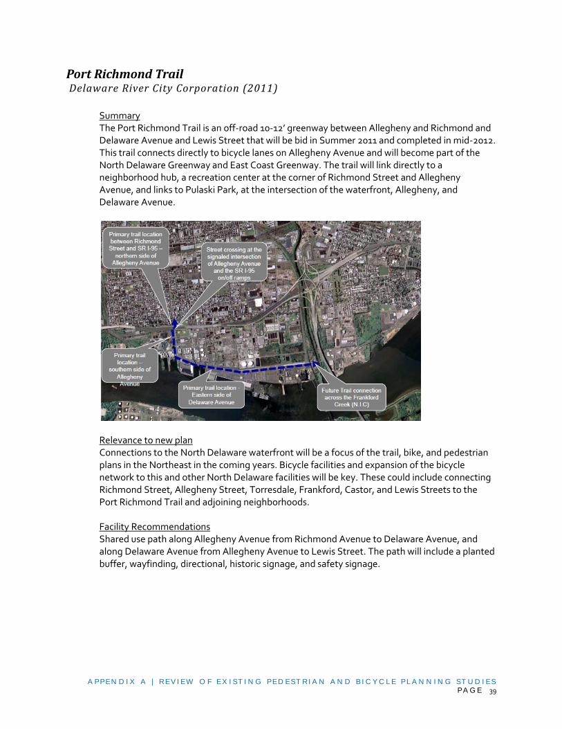
A PPEN D I X A | REV I EW O F EX I ST I N G PED EST RI A N A N D B I C Y C L E PL A N N I N G ST U D I ES PA G E 39
Port Richmond Trail Delaware River City Corporation (2011)
Summary The Port Richmond Trail is an off-road 10-12’ greenway between Allegheny and Richmond and Delaware Avenue and Lewis Street that will be bid in Summer 2011 and completed in mid-2012. This trail connects directly to bicycle lanes on Allegheny Avenue and will become part of the North Delaware Greenway and East Coast Greenway. The trail will link directly to a neighborhood hub, a recreation center at the corner of Richmond Street and Allegheny Avenue, and links to Pulaski Park, at the intersection of the waterfront, Allegheny, and Delaware Avenue.
Relevance to new plan Connections to the North Delaware waterfront will be a focus of the trail, bike, and pedestrian plans in the Northeast in the coming years. Bicycle facilities and expansion of the bicycle network to this and other North Delaware facilities will be key. These could include connecting Richmond Street, Allegheny Street, Torresdale, Frankford, Castor, and Lewis Streets to the Port Richmond Trail and adjoining neighborhoods. Facility Recommendations Shared use path along Allegheny Avenue from Richmond Avenue to Delaware Avenue, and along Delaware Avenue from Allegheny Avenue to Lewis Street. The path will include a planted buffer, wayfinding, directional, historic signage, and safety signage.

A PPEN D I X A | REV I EW O F EX I ST I N G PED EST RI A N A N D B I C Y C L E PL A N N I N G ST U D I ES PA G E 40
Lardner’s Point Park Delaware River City Corporation, to be built 2011-2012
Summary Lardner’s Point Park is along the North Delaware Greenway under the Tacony Palmyra Bridge that will be bid in summer 2011 and is nearly fully funded. The park will function as a waterfront amenity for the adjoining neighborhoods but also will feature a trail head with parking and comfort facilities and a portion of the trail is part of the North Delaware Greenway.
Relevance to new plan Connections to the North Delaware waterfront will be a focus of the trail, bike, and pedestrian plans in the Northeast in the coming years. Bicycle facilities and expansion of the bicycle network to this and other North Delaware facilities will be key. These could include connecting Comly, Unruh, Princeton, Tacony, State, and New State Road to Lardner’s Point Park and adjoining neighborhoods. Facility Recommendations No network recommendations, site plan only.
Poquessing Creek Park Trail Improvements Philadelphia Parks & Recreation, Design completed 2011
Summary Poquessing Creek Park Trail extension will connect Junod Playground on Dunks Ferry Road to Benjamin Rush State Park on Roosevelt Boulevard. There is currently no connection off-road or direct connection between the disjointed Poquessing Creek Park and neighborhoods. The trail will also provide a connection to Benjamin Rush State Park, currently only accessible by car via Roosevelt Boulevard, not a bike- or pedestrian-friendly alternative. Finally, there will be a direct connection via the trail to Bucks County, as there is a bridge over the Poquessing at the

A PPEN D I X A | REV I EW O F EX I ST I N G PED EST RI A N A N D B I C Y C L E PL A N N I N G ST U D I ES PA G E 41
terminus of the trail. The trail will be 10-12’ paved and connect to the recreation center, through easements on private land, over a brook, and back to Fairmount Park property. Relevance to new plan The new trail will foster neighborhood connections to green space. Direct or nearby bike lane and sidewalk connections to each planned trailhead would increase community access to the trail facilities. Adjacent and nearby roadways include: Dunks Ferry Road, Roosevelt Boulevard, Byberry Road, Knights Road, Academy Road, Thornton Road, Southampton Road, and Townsend Road. Facility Recommendations Trail with trailheads at Dunks Ferry Road, McNulty Road, Mechanicsville Road
East Coast Greenway Alignment Alternatives Study Pennsylvania Environmental Council
Summary This study investigates six potential alignments for the East Coast Greenway from Philadelphia to Darby Creek in Delaware County. The purpose of the study is to provide PA Environmental Council with a framework for prioritization and implementation of the Greenway.

A PPEN D I X A | REV I EW O F EX I ST I N G PED EST RI A N A N D B I C Y C L E PL A N N I N G ST U D I ES PA G E 42
Relevance to the new plan The study provides a detailed inventory of natural and cultural resources along each of the alignments. Some of the alignments are described as acceptable cycle routes but not suitable for pedestrians. This portion of the trail system would provide access to the Philadelphia International Airport.
Facility Recommendations The study concludes that the ideal long-term alignment is an off-road alignment (A) utilizing the Schuylkill Trail Extension and future Fort Mifflin Trail. Right of way and potential contamination, as well as cost, are cited as potential obstacles to securing this alignment. In the interim, it recommends (F) an inland alignment which travels along the Darby Creek and Cobbs Creek trails. This alignment utilizes low traffic volume streets for the on-road portion and also provides access to the John Heinz National Wildlife Refuge. The alignment of recommendation F, from east to west within Philadelphia, follows: Lindbergh Boulevard, Elmwood Avenue, 58thStreet, Chester Avenue, 59thStreet (all of which are part of the soon to be constructed 58th Street Greenway, described at the end of this section), Cobbs Creek Trail, Elmwood Avenue, Lindbergh Boulevard, and the Heinz Refuge driveway.
Improving Pedestrian and Bicycle Access to the John Heinz National Wildlife Refuge Clean Air Council (October, 2007)
Summary This study investigated four opportunities to connect the surrounding neighborhoods, particularly those south of I-95, to the John Heinz National Wildlife Refuge (JHNWR). Two of the options are located within Philadelphia city limits, the first providing access from the Eastwick SEPTA station and the second providing access from the airport along the abandoned Chester Short Line trolley bed. These connections will help to bridge a critical gap between the three major trail systems in the area: the Cobbs Creek Trail, the future Tinicum-Fort Mifflin Trail, and the extension of the Schuylkill River Trail, all of which are part of the proposed alignment for the East Coast Greenway through this region. Relevance to the new plan While both of the access points within Philadelphia are informally utilized today, the upgraded paths and wayfinding will improve access to the neighborhood thereby Proposed Eastwick Station Connection
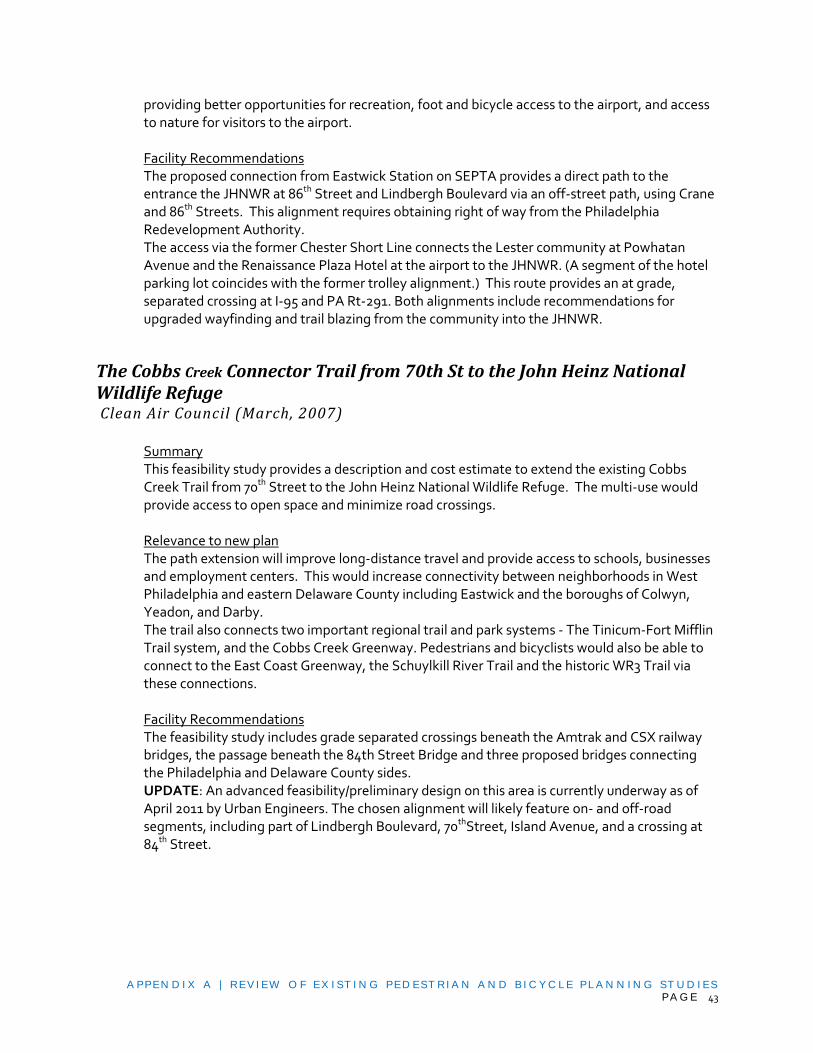
A PPEN D I X A | REV I EW O F EX I ST I N G PED EST RI A N A N D B I C Y C L E PL A N N I N G ST U D I ES PA G E 43
providing better opportunities for recreation, foot and bicycle access to the airport, and access to nature for visitors to the airport. Facility Recommendations The proposed connection from Eastwick Station on SEPTA provides a direct path to the entrance the JHNWR at 86th Street and Lindbergh Boulevard via an off-street path, using Crane and 86th Streets. This alignment requires obtaining right of way from the Philadelphia Redevelopment Authority. The access via the former Chester Short Line connects the Lester community at Powhatan Avenue and the Renaissance Plaza Hotel at the airport to the JHNWR. (A segment of the hotel parking lot coincides with the former trolley alignment.) This route provides an at grade, separated crossing at I-95 and PA Rt-291. Both alignments include recommendations for upgraded wayfinding and trail blazing from the community into the JHNWR.
The Cobbs Creek Connector Trail from 70th St to the John Heinz National Wildlife Refuge Clean Air Council (March, 2007)
Summary This feasibility study provides a description and cost estimate to extend the existing Cobbs Creek Trail from 70th Street to the John Heinz National Wildlife Refuge. The multi-use would provide access to open space and minimize road crossings. Relevance to new plan The path extension will improve long-distance travel and provide access to schools, businesses and employment centers. This would increase connectivity between neighborhoods in West Philadelphia and eastern Delaware County including Eastwick and the boroughs of Colwyn, Yeadon, and Darby. The trail also connects two important regional trail and park systems - The Tinicum-Fort Mifflin Trail system, and the Cobbs Creek Greenway. Pedestrians and bicyclists would also be able to connect to the East Coast Greenway, the Schuylkill River Trail and the historic WR3 Trail via these connections. Facility Recommendations The feasibility study includes grade separated crossings beneath the Amtrak and CSX railway bridges, the passage beneath the 84th Street Bridge and three proposed bridges connecting the Philadelphia and Delaware County sides. UPDATE: An advanced feasibility/preliminary design on this area is currently underway as of April 2011 by Urban Engineers. The chosen alignment will likely feature on- and off-road segments, including part of Lindbergh Boulevard, 70thStreet, Island Avenue, and a crossing at 84th Street.

A PPEN D I X A | REV I EW O F EX I ST I N G PED EST RI A N A N D B I C Y C L E PL A N N I N G ST U D I ES PA G E 44
Trail Development Study for the Tinicum-Fort Mifflin Trail The Clean Air Council (June, 2003)
Summary The purpose of the Tinicum-Fort Mifflin Trail is to increase access and visibility to Fort Mifflin while providing a riverfront path from Essington, in Tinicum to the southern edge of Philadelphia. From here, the proposed Schuylkill River Trail extension would connect to the heart of Philadelphia. The Tinicum-Fort Mifflin trail will be 11.3 miles long. With few exceptions, the proposed alignment is along available right of way. However, expansion plans for the airport could have a significant impact on the trail alignment. Relevance to the new plan
A short-term version of the trail is mainly on-street from Bartram Gardens to Fort Mifflin mainly along Lindbergh Boulevard or Essington Ave and Island Avenue. Following the implementation of the long-term, off-road alignment, the on-street improvements will continue to serve the neighborhood bike network. This on-street system will also provide a connection with the Cobbs Creek Trail.
Facility Recommendations Specific recommendations include:
Potential sidepath on Lindbergh Boulevard
Bike lanes on Fort Mifflin Road
Signage and wayfinding improvements at trail heads and along city streets, including Island Avenue, Enterprise Avenue, 84th Street, 2nd Street (Tinicum Township), and Wanamaker Road (Tinicum Township)
58th Street Greenway Pennsylvania Environmental Council (2011)
Summary The 58th Street Greenway is a planned on and off-road greenway in Southwest Philadelphia along Lindbergh Boulevard, Elmwood Avenue, 58thStreet, Chester Avenue, and 59th Street. The Greenway will connect Bartram’s Garden to the Cobbs Creek Greenway and serve as a key bicycle and recreation facility and part of the East Coast Greenway. The project is a Federal TIGER funded project and will be constructed between 2011-2012.
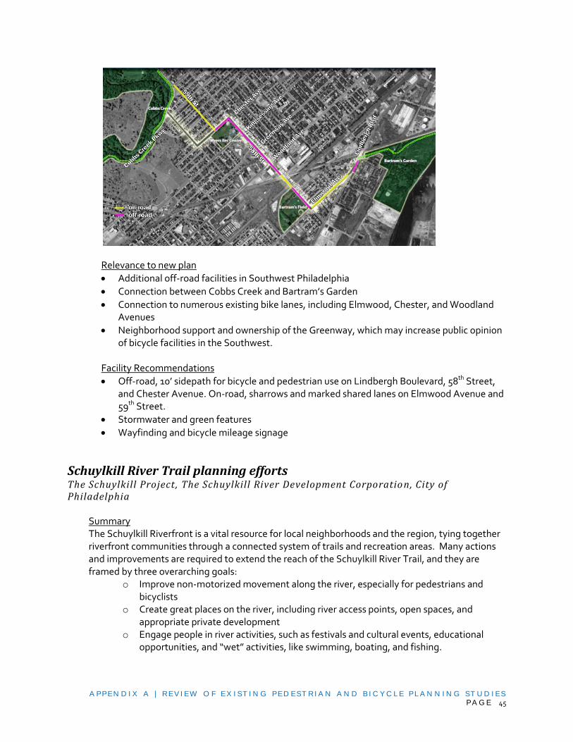
A PPEN D I X A | REV I EW O F EX I ST I N G PED EST RI A N A N D B I C Y C L E PL A N N I N G ST U D I ES PA G E 45
Relevance to new plan
Additional off-road facilities in Southwest Philadelphia
Connection between Cobbs Creek and Bartram’s Garden
Connection to numerous existing bike lanes, including Elmwood, Chester, and Woodland Avenues
Neighborhood support and ownership of the Greenway, which may increase public opinion of bicycle facilities in the Southwest.
Facility Recommendations
Off-road, 10’ sidepath for bicycle and pedestrian use on Lindbergh Boulevard, 58th Street, and Chester Avenue. On-road, sharrows and marked shared lanes on Elmwood Avenue and 59th Street.
Stormwater and green features
Wayfinding and bicycle mileage signage
Schuylkill River Trail planning efforts The Schuylkill Project , The Schuylkill River Development Corporatio n, City of Philadelphia
Summary The Schuylkill Riverfront is a vital resource for local neighborhoods and the region, tying together riverfront communities through a connected system of trails and recreation areas. Many actions and improvements are required to extend the reach of the Schuylkill River Trail, and they are framed by three overarching goals:
o Improve non-motorized movement along the river, especially for pedestrians and bicyclists
o Create great places on the river, including river access points, open spaces, and appropriate private development
o Engage people in river activities, such as festivals and cultural events, educational opportunities, and “wet” activities, like swimming, boating, and fishing.

A PPEN D I X A | REV I EW O F EX I ST I N G PED EST RI A N A N D B I C Y C L E PL A N N I N G ST U D I ES PA G E 46
Some of the projects prioritized by various master plans include closing several gaps on the Wissahickon Creek trails, providing river access north of the Falls Bridge in East Falls, restoration of the Manayunk Canal Locks, and renovation of the Bathey House building for private development and public use.
Relevance to the new plan The first goal mentioned above is directly relevant to the City’s goal for the Philadelphia Pedestrian and Bicycle Plan to “increase the number and frequency of people walking and bicycling within the City of Philadelphia.” Further, the proposed actions include closing gaps in the shared-use trail system, improving and maintaining the quality of the trails through landscaping and wayfinding signage, and improving pedestrian and bicycle movement on nearby streets. Existing and future Schuylkill River Trail facilities are visualized on the following map:

A PPEN D I X A | REV I EW O F EX I ST I N G PED EST RI A N A N D B I C Y C L E PL A N N I N G ST U D I ES PA G E 47
Schuylkill River Trail Development Map

A PPEN D I X A | REV I EW O F EX I ST I N G PED EST RI A N A N D B I C Y C L E PL A N N I N G ST U D I ES PA G E 48
Facility Recommendations (Schuylkill River Trail) Tidal Schuylkill River Master Plan (March 2003)
- Improved pedestrian connections to the Philadelphia Zoo - South Street Bridge pedestrian access ramps (Center City/University City) - Extension of "High Line Park" to connect the Mill Creek Greenway
and the Schuylkill River Trail (Center City/University City) - Greenway along the riverfront at Historic Bartram’s Garden - Greenway on one or both sides of the river (Passyunk Crescent/Sunoco Area) - Waterfront walkway (Water Activity Center) - Provide a Greenway along the river to link Fairmount Park areas above the Dam with Fort
Mifflin - Grays Ferry Crescent Greenway: The City and the United States Army Corps of Engineers are
working together to develop a 100’ wide greenway from University Avenue Bridge to Gray’s Ferry Bridge.
- Bartram's Trail North: Create a pedestrian and bicycle trail from Historic Bartram's Garden north to the Grays Ferry Bridge.
Schuylkill Trails Master Plan – South Street to Bartrams Garden (August 2005)
- Grays Ferry Avenue Streetscape Improvements o Bicycle Lanes in each direction on Grays Ferry Ave. from Washington Ave. to the Bridge o Sidewalk improvements from Ellsworth to 31st Street, o Both are intended to better connect Schuylkill Trails to surrounding neighborhoods
- Water’s Edge North o Construct a structured trail at water’s edge
- Water’s Edge South o Construct a structured trail at water’s edge where necessary o Create two points of neighborhood access: one at the shopping center entrance and
one down Ellsworth Street. Both entrances to the waterfront trail will require pedestrian and bike-friendly ramps.
o Improve the pedestrian environment along Grays Ferry Avenue through the creation of street trees, planting beds, and improved lighting.
- Crescent Beach o Connect waterfront trail to adjacent east parcel through tunnel o Create safe and accessible entry point from the University Avenue Bridge
- Schuylkill Bend o Continue streetscape improvements to entrance of Grays Ferry Bridge.
- Forgotten Bottom Park o Re-position existing railroad bridge for use as primary pedestrian and bicycle access. o Provide neighborhood access to the waterfront trail from Grays Ferry Avenue, near
entrance to the Bridge. o Extend a spur of the trail to the Trolley Works site where future active and passive
recreation is proposed.
A PPEN D I X A | REV I EW O F EX I ST I N G PED EST RI A N A N D B I C Y C L E PL A N N I N G ST U D I ES PA G E 49
East Coast Greenway East/West Connectivity Study Pennsylvania Environmental Council
Summary This study is intended to find an on-road route for the East Coast Greenway (ECG) to pass through the city from east to west after coming down from north of Philadelphia along the Riverfront Trail, and before the ECG heads south out of the city via the Schuylkill River Trail. This plan is still in its preliminary stages, and new information will be incorporated into the Philadelphia Pedestrian and Bicycle Plan as it becomes available. Draft recommendations (as of Oct. 2008) At this point in the planning process, there are three east-to-west routes under consideration. These routes are also drawn on the map to the right.
1. Spring Garden Street 2. Benjamin Franklin Parkway/East Market Street, Independence National Historic Park 3. Spruce Street
Cresheim Trail Feasibility Study Friends of the Cresheim Trail (January 2008)
Summary Recently approved by the Cresheim Trail Committee, this study investigates the feasibility of a multi-use recreational trail linking portions of Whitemarsh, Springfield and Cheltenham Townships in Montgomery County to the Wissahickon section of Fairmount Park in Philadelphia. The proposed trail would extend for approximately six miles and would connect to Wissahickon Creek at both its north and south ends. This study looks at links between the proposed trail and neighboring communities, intending to facilitate these linkages. The study also considers opportunities and constraints affecting the proposed trail alignment, and it outlines recommendations for implementation.
Relevance to the new plan As demonstrated by the map below (excerpted from the Cresheim Trail Feasibility Study), this multi-use trail will connect Philadelphians to an extensive network of existing and proposed trails throughout Montgomery County, to the northwest of the city (Cresheim Trail is

A PPEN D I X A | REV I EW O F EX I ST I N G PED EST RI A N A N D B I C Y C L E PL A N N I N G ST U D I ES PA G E 50
highlighted in yellow in the below map). Any plans to enhance this trail network provide added incentive for recreational cyclists to ride out from Philadelphia to enjoy the nearby countryside.
Montgomery County Planning Commission
CORRIDOR PLANS AND STUDIES
Frankford Avenue Corridor TOD Philadelphia City Planning Commission (July 2006)
Summary This plan is very similar to the West Market Street Corridor TOD report completed at the same time. As part of a comprehensive Transit Oriented Development Plan, the study highlights the importance of creating a pedestrian-oriented environment and improved bicycle accommodation. Relevance for the new plan The plan identifies primary pedestrian access routes to the stations along Frankford Avenue. It includes recommendations for geometric improvements to intersections as well as sidewalk treatments such as curb extensions, pedestrian lighting and specialty paving. The plan proposes a Transit Oriented Development zoning overlay which would include guidelines for bike parking in commercial development and FAR bonuses for public open space. The plan describes a Parking Benefit District to pay for improvements and bicycle facilities. The plan also suggests sidewalk maintenance program and on-going evaluation of the pedestrian environment.

A PPEN D I X A | REV I EW O F EX I ST I N G PED EST RI A N A N D B I C Y C L E PL A N N I N G ST U D I ES PA G E 51
Facility Recommendations
Station access streets between Penn Street and Duffield Street should receive sidewalk, landscaping, lighting, and signage improvements. The intersections of the station access streets with Frankford Avenue should be prioritized for pedestrian-friendly design.
Add pedestrian connections through parking lots and development sites.
Convert alleys and small streets near subway stations to exclusive pedestrian use (Granite St, Paul St.).
Provide curb extensions and sidewalk widenings where the columns of the El narrow the sidewalk.
Reconfigure related intersections of Frankford/Oxford/Margaret/Arrott/Paul to improve sight lines, shorten crossing distances, and simplify signal timing.
Maintain uncontrolled crossings of Frankford Avenue through mid-block crosswalks, pedestrian signals, and/or refuge islands (Granite).
Add bike parking at the Erie-Torresdale station (outside the study area) to connect to existing bike lanes.
Install bicycle lanes on Frankford and Bustleton Avenues north of the Frankford Transportation Center.
Fill in several-block gap on Oxford Avenue with bike lanes or sharrows and signage.
North Delaware Riverfront Rail Stations Urban Design Study Philadelphia City Planning Commission (April 2008)
Summary The study examines five stations along the R7 line that connects Philadelphia to Trenton, NJ. The stations are located on the Delaware Riverfront; they are: Bridesburg, Wissinoming, Tacony, Holmesburg Junction, and Torresdale. The study recommends station area improvements, pedestrian and bicycle connector upgrades and potential redevelopment sites. The objective of the study is to recommend ways to transform each station into an active, community asset and to encourage ridership on the line. Relevance to the new plan One of the goals of the study is to promote walking and biking in addition to transit use. Many of the recommendations focus on “connector streets” that provide access to the stations.

A PPEN D I X A | REV I EW O F EX I ST I N G PED EST RI A N A N D B I C Y C L E PL A N N I N G ST U D I ES PA G E 52
Recommendations include traffic calming, adding bicycle lanes, signage and pedestrian amenities. Facility Recommendations
Intersection improvements at: State Road and Grant Avenue; James Street and Grant Avenue; Rhawn Street and State Road; Comly and Tacony Streets; Bridge and Harbison Streets; and Bridge and Tacony Streets.
Traffic calming on Rhawn Street from Torresdale Avenue to State Road.
A bike station on Rhawn Street at Holmesburg Junction.
Create a Poquessing Creek Trail.
Create a new north-south riverfront street to connect the former Dodge Steel site to the Tacony Army Warehouses.
Add bike lanes to Comly, Keystone and Tulip Streets near Wissinoming Station
Road diet with bike lanes on Bridge Street from Torresdale Avenue to future North Delaware Greenway.
Upgrade Comly Street as a pedestrian connector
US 1 Roosevelt Boulevard Corridor Study Delaware Valley Regional Planning Commission (2007)
Summary This study looks at 8 miles of Roosevelt Boulevard from 9th Street to Grant Avenue. The report is a traffic and safety study focused on strategies for improving pedestrian safety. It examined all of the pedestrian crossings and vehicular “crossovers,” which provide access from the express lanes to service roads and vice versa. The study also analyzed a reconfiguration of the Boulevard that would consolidate the express and local lanes, eliminating the side medians and crossovers, reducing the total number of lanes from twelve to ten, simplifying operations at the intersections, and adding bike lanes.

A PPEN D I X A | REV I EW O F EX I ST I N G PED EST RI A N A N D B I C Y C L E PL A N N I N G ST U D I ES PA G E 53
Relevance to the new plan Fourteen intersections were studied, along with ten unsignalized crosswalks. Since the study, the unsignalized crossings are in the process of being upgraded to signals or eliminated. The study provides thorough information on each crossing including crash data, the profile of pedestrians observed during counts (e.g. adults, school children, bus riders), as well as orthophotos of each crossing. There are numerous schools located on either side of the corridor. As a result, a very high number of the pedestrians observed at crossings throughout the corridor were school children. Bus riders were also present in high numbers. Roosevelt at C Street was the busiest weekday pedestrian crossing observed (with many school children); the crossing at Cottman Ave had the highest volume of pedestrians overall. Both Cottman Avenue and C Street are nodes of bus service. Facility Recommendations
The study indicated types of pedestrian improvements for each crossing, such as restriping the crosswalks, installing countdown pedestrian signals, safety signage, revising the pedestrian crossing time, and relocation of bus stops. The study also recommended eliminating several crossovers and mid-block crossings.
Of the 10 unsignalized crosswalks, 5 were recommended to be upgraded with traffic signals (with countdowns), and 5 were recommended for removal.
Twelve of 37 crossovers were recommended for removal, while ten were recommended to be lengthened.
Roosevelt Boulevard Corridor Transportation Investment Study Philadelphia City Planning Commission (2003)
Summary
This study examined a variety of alternatives to improve transportation in the Roosevelt Boulevard corridor, ranging from heavy and light rail to express bus, with an option of grade-separating the express traffic lanes. The selected preferred alternative (C’) was a new subway/elevated line in the center median of Roosevelt Boulevard, connecting to the Broad Street Subway Line. For this alternative, the rail would be in an open cut at the stations only.
Relevance for the new plan This proposal would increase transit options for residents, employees, and shoppers along the Roosevelt Boulevard corridor. Most of the focus was on three rail alternatives. Of these, Alternative C, the most costly, would allow for a multi-use path along the median.

A PPEN D I X A | REV I EW O F EX I ST I N G PED EST RI A N A N D B I C Y C L E PL A N N I N G ST U D I ES PA G E 54
Alternative D, the most finance-able, would limit pedestrian crossings to locations with overpasses or pedestrian bridges. Alternative C’, the Locally Preferred Alternative, would not significantly change the pedestrian crossings, nor would it facilitate a median path. Facility Recommendations The study did not recommend an alternative.
Cheltenham Avenue: A Plan for Bridging the Communities, Phase I Cheltenham Township/Northwest Philadelphia Joint Planning Initiative
Summary This planning document focuses on Cheltenham Avenue from Easton Road to North Broad Street, and on several nodes along or near it. The study is part of an on-going joint effort between the City of Philadelphia and Cheltenham Township to strengthen and revitalize neighborhood commercial centers.
Relevance for new plan Recommendations address development controls and the public environment, particularly pedestrian safety and transit access. There is no mention of bicycle accommodations, except to say that Cheltenham Avenue has excess capacity and traffic lanes could be converted to bike lanes in some areas. Facility Recommendations
At Cheltenham Avenue and Ogontz Avenue: strengthen transit and pedestrian connections through widened sidewalk with street trees, safer crossings, improved bus stops.
At Cheltenham Avenue and Easton Road/Wadsworth Avenue: add bump-outs to shorten pedestrian crossings; add bus shelters.
Streetscape recommendations for all corridors and nodes include continuous sidewalks with landscaped buffers; raised landscaped medians; consistent street lighting with a “kit-of-parts” approach to pedestrian lighting; wayfinding signs; bus shelters with

A PPEN D I X A | REV I EW O F EX I ST I N G PED EST RI A N A N D B I C Y C L E PL A N N I N G ST U D I ES PA G E 55
seating; more trees in front yards and parking lots; and improved pedestrian connections between public sidewalks and building entrances.
Cheltenham Avenue, Phase III: Related Neighborhood Commercial Centers Cheltenham Township/Northwest Philadelphia Joint Planning Initiative (2007)
Summary This planning document focuses on retail corridors near Cheltenham Avenue between Easton Road and North Broad Street, as part of an on-going joint effort between the City of Philadelphia and Cheltenham Township to strengthen and revitalize neighborhood commercial centers. Relevance for new plan The recommendations for funding in nearly every district include façade improvements, pedestrian-scale lighting, wayfinding, tree planting and promoting specific development opportunities. There is no mention of bicycle accommodations. Facility Recommendations In addition to the general improvements listed above, the following are specific recommendations related to pedestrians.
Washington Lane at LimeKiln Pike: Replace curbs and sidewalks.
Stenton Avenue near Mt. Airy Avenue: Edge Landscaping and fencing along parking areas.
Stenton Avenue near Washington Avenue: Replace curbs and sidewalks.
Central Delaware Waterfront Master Plan Delaware River Waterfront Corporation (2011)
Summary Though not released until June of 2011, at this point we know the Plan will include several recommendations for economic development, greening, and public use of the waterfront. The plan will lay out recommendations to bring investment and people to the waterfront.

A PPEN D I X A | REV I EW O F EX I ST I N G PED EST RI A N A N D B I C Y C L E PL A N N I N G ST U D I ES PA G E 56
Relevance to New Plan The plan will recommend a series of connector streets between neighborhoods and the waterfront, as well as a green space every ½ mile at the end of each connector street. Green streets are also proposed, which are streets with stormwater and green planted amenities and are inviting for pedestrian and bicycle traffic. Proposed green streets in the Phase 2 study area include:
Columbia
Berks
Cumberland
Lehigh
Somerset
Allegheny These will connect to a waterfront bike trail that will run from Tasker to Penn Treaty Park at Columbia Avenue in a timeline of roughly 5 years. Facility Recommendations The Plan is broad and conceptual at this time and is scheduled for a June 2011 release date.
Baltimore Avenue Community Corridor Design Study Cedar Park Neighbors Association (2010)
Summary This project included the conceptual design for a master plan for revitalizing Baltimore Avenue from 49th Street to 52nd Street. The plan includes building façade renovations, redevelopment, new civic space, and streetscape improvements. Relevance to the new plan The primary goal was to restore a sense of continuity and vitality between two strategic pedestrian-oriented commercial corridors: Baltimore Avenue and 52nd Street. Traffic calming at intersections was also a goal. Facility Recommendations include:
- Bumpouts at all intersections on Baltimore Avenue from 49th to 52nd Street, Catherine and 50th Streets.
- Create a “green corridor” along 51st Street to connect Baltimore Avenue with Malcolm X Park to north (at Larchwood) and Kingsessing Park to south. The proposal would include bike lanes in the street, and would add street trees in urban bioswales, reducing the Walking Zone to 5’.
- Whitby Avenue 5100 block: add bumpouts and green center median or angle parking. - Add plaza at southwest corner of Baltimore Avenue and 51st Street. - Streetscape improvements

A PPEN D I X A | REV I EW O F EX I ST I N G PED EST RI A N A N D B I C Y C L E PL A N N I N G ST U D I ES PA G E 57
US 30 Corridor Study (Draft) Delaware Valley Regional Planning Commission (2010)
Summary The US 30 Corridor Study was initiated by the Delaware Valley Regional Planning Commission to help coordinate transportation and land use planning across a multi-county corridor stretching from West Philadelphia through Delaware County to Chester County. The draft document presents preliminary recommendations.
Relevance to the new plan A figure shows many “bike route modifications” in the Philadelphia portion of the study area, but there is no text to accompany these recommendations, with one exception. Pedestrian recommendations are included for each subarea of the report. Facility Recommendations include:
- Stripe bike lanes along 59th Street between Lancaster Avenue and Upland Way. - Continue streetscape improvements such as sidewalks, street trees, high visibility
crosswalks, pedestrian scaled lighting, and street furniture, along Lancaster Avenue between 52nd and 59th Streets and along 59th Street from Lancaster Avenue to Upland Way.

A PPEN D I X A | REV I EW O F EX I ST I N G PED EST RI A N A N D B I C Y C L E PL A N N I N G ST U D I ES PA G E 58
City Avenue Access Management Delaware Valley Regional Planning Commission (2005)
Summary This report uses the section of City Avenue between 54th Street and I-76 as PENNDOT case-study for access management on major corridors. Access management aims to improve safety and efficiency by formalizing the roadway with medians and turn lanes while limiting curb cuts. Relevance to the new plan The study includes crash data and lists lack of pedestrian refuges, excessive curb cuts, high traffic volume, and high turning volumes as potential causes of pedestrian crashes. This area of this case study exhibits densely developed mixed land uses with nodes of heavy pedestrian activity, but access management strategies have been used successfully to reduce crashes in a highly congested area. Facility Recommendations
- Install a non-traversable median with dedicated left turn lanes west of Kings Grant Drive to 54th Street.
- Reduce the number of driveways by half and provide joint access through remaining driveways. Increase average driveway spacing to 500 feet, and make more use of side streets for property access.
- Add two bus pull-outs - at mid-block locations; though passengers would be forced to walk to the nearest intersection to cross. On the Philadelphia side, a bus pull-out is recommended between 51st Street and Bala Avenue while, on the Montgomery County side, the bus pull-out is recommended between Bryn Mawr Avenue and Bala Avenue.
- Add right turn deceleration lanes at Conshocken State Road, 47th Street, Belmont Avenue, Stout Road, Kings Grant Drive, Decker Boulevard, and Monument Road intersections.
Taming Traffic (Parkside Avenue) Delaware Valley Regional Planning Commission (2007)
Summary This report is one in a series to apply traffic calming to problem locations in the DVRPC region. One of the locations studied in the report is Parkside Avenue from the intersection of 40th Street and Girard Avenue to the intersection with 52nd Street. Six main issues were identified that could be addressed through traffic calming and context-sensitive solutions, and specific improvements were focused on 7 locations. Relevance to the new plan Parkside Avenue was identified as a barrier in the Centennial District Master Plan. It carries a significant amount of traffic and the western half is regularly used for motorcycle racing. Among the issues addressed is the insufficient number of pedestrian crossings, especially west of Belmont Avenue. The Girard Avenue intersection was cited as confusing and potentially dangerous.

A PPEN D I X A | REV I EW O F EX I ST I N G PED EST RI A N A N D B I C Y C L E PL A N N I N G ST U D I ES PA G E 59
Facility Recommendations include:
- Add center median to Parkside Avenue between 52nd and 40th Streets. - Reconfigure 52nd Street intersection to shorten pedestrian crossings. - Add traffic signal and pedestrian crossing at 51st Street intersection. - Install an Urban Single Lane roundabout at 50th Street, realigning 50th Street to
become one of three approaches, and adding pedestrian crossings at all approaches. - Add pedestrian crossing at 49th Street and improve passenger facilities at the bus
turnaround. - Install a midblock crosswalk aligned with the sidewalk along West Memorial Hall Drive,
and close East Memorial Hall Drive. - Reconfigure the park access roads at 41st Street, to straighten the crosswalks and
create a safer intersection. - Add midblock crosswalk north of Girard Avenue, at entrance to High School of the
Future. - Reconfigure intersection of Parkside and Girard, closing the right-turn channel from
Girard to Parkside, and replacing it with a traditional exclusive right turn lane at the intersection.
West Market Street Corridor TOD Philadelphia City Planning Commission (July 2006)
Summary This is a comprehensive plan for station-area redevelopment along the Market Street corridor, specifically the stations between 46th Street and 63rd Street, in anticipation of the elevated line rehabilitation. It addresses transportation, land-use, zoning, parking management, redevelopment strategies and funding sources. Overall it promotes guidelines and tools for creating transit oriented development with a mixture of uses and transportation options. Relevance to the new plan The plan provides recommendations for streetscape and intersection improvements along the entire corridor. The plan proposes categorizing side streets as primary and secondary pedestrian access corridors to the stations and organizing streetscape improvements accordingly. It also includes bike racks and bike stations. The plan describes a Parking Benefit District to pay for improvements and bicycle facilities. The plan also suggests on-going evaluation and maintenance of the pedestrian environment.

A PPEN D I X A | REV I EW O F EX I ST I N G PED EST RI A N A N D B I C Y C L E PL A N N I N G ST U D I ES PA G E 60
Facility Recommendations - Intersections of station access streets with Arch, Market, and Chestnut Streets should
get priority for pedestrian-friendly design. - Add pedestrian connections through parking lots and development sites. - Provide curb extensions and sidewalk widenings where the columns of the El narrow
the sidewalk. - Add pedestrian-scale lighting, especially at intersections and mid-block crossings. - Convert alleys and small streets near subway stations to exclusive pedestrian use. - Limit through traffic on Market Street, to reduce speeding. - Mark bike lanes on Chestnut, Walnut, 52nd, and 54th Streets, but not on Market Street,
because of concern for double parking. - Encourage bike parking in and near station areas, and a bike station at 63rd Street
Station.
Civic Vision for the Central Delaware – Mobility chapter Penn Praxis (November 2007)
Summary This civic vision recommends improving movement systems along the central Delaware riverfront by increasing opportunities for public access to the riverfront and shaping urban development through infrastructure investment and land-use and transportation policies that allow for multiple transportation modes. At present, the central Delaware riverfront is generally oriented to automobiles and is difficult to traverse on foot and bike. The riverfront is also inadequately served by public transit. Sidewalks at riverfront destinations are often narrow, disconnected and sometimes missing altogether.
Relevance to the new plan The Central Delaware Waterfront Plan, through its recommendations, emphasizes the importance of diversity in mode choice and the urban-style density of development that makes trips by foot, bike, and transit realistic options. The end goal of the plan is to transform the waterfront into a “multi-modal, dense, and walkable” corridor. Such a corridor would likely be safer for existing pedestrians, and also would draw new walkers, which are two key objectives of the Philadelphia Pedestrian and Bicycle Plan. Facility Recommendations
- Create a new Delaware Boulevard that is pedestrian-oriented, landscaped, and multimodal.
- Create a street network that extends the city’s existing street grid on the west side of I-95 all the way to the river, including a network of sidewalks and continuous riverfront access.
- Expand the transit system: establish policies that minimize the impact of traffic and parking on the environment, support new riverfront activity, and increase connections to neighborhoods and existing transit lines.
- Create a continuous riverfront trail, along the river where possible, along the Boulevard where necessary.

A PPEN D I X A | REV I EW O F EX I ST I N G PED EST RI A N A N D B I C Y C L E PL A N N I N G ST U D I ES PA G E 61
North Broad Street Transportation and Access Study Philadelphia City Planning Commission (June 2007)
Summary This study analyzed strategies to improve overall access to destinations along the North Broad Street corridor; help balance the needs of all roadway users, including motorists, transit riders, cyclists, and pedestrians; create a better balance among the various types of vehicle parking (on-street and off-street); and improve connectivity and safety for cyclists and pedestrians in particular. The study included a detailed analysis of options for adding bike lanes to Broad Street, but all were ultimately ruled out.
Relevance to the new plan This study identifies needed non-motorized improvements in the North Broad Street corridor, such as Share-the-Road signage, added bike parking, additional time for pedestrian crossings, pedestrian countdown timers, and wayfinding signs. The figure below shows locations where bicycle crashes are occurring at the highest frequencies (symbolized by red X’s), which will be useful to help prioritize intersections for safety enhancements. Typically, collisions occur more often at intersections than they do along mid-block segments. Facility Recommendations Bicycle Facilities
- Additional “Share the Road” signs - Cyclists should be encouraged to use the numbered streets parallel to Broad Street –
such as 16th Street or 13th Street (pavement in good repair), also 15th Street (poorer pavement quality)
- Bicycle racks greatly needed, especially near Hahnemann Hospital, the State Office Building, Philadelphia Community College, the Convention Center and Temple University
Bicycle facilities and conditions : North Broad Street

A PPEN D I X A | REV I EW O F EX I ST I N G PED EST RI A N A N D B I C Y C L E PL A N N I N G ST U D I ES PA G E 62
Pedestrian Facilities
- Set signal progression for slower speed; - Using 60-second cycle during off-peak times rather than 90 second cycle - Introduce raised islands in the median area, as on South Broad Street. - Install countdown signals - Consider a leading pedestrian interval of three to five seconds to allow pedestrians a
headstart in the crosswalk at Broad and Vine Streets. - Wayfinding signs would increase awareness of the attractions as well as provide direction.
Benjamin Franklin Parkway Circulation, Parking, and Transit Study City of Philadelphia (January 2007)
Summary This study was conducted to help incorporate the Benjamin Franklin Parkway more seamlessly into the fabric of the neighboring community. The vision was that it would become a resource that everybody can drive, bike, and walk along and across comfortably. The study observed that while the Parkway is a “beautiful urban boulevard,” it does “suffer from a primacy of vehicle traffic, intersections that are overwhelming to pedestrians, unappealing bicycle lanes, and frequent disruption from special events.” Relevance to the new plan Because it is such a key open space and transportation facility in Center City, the Philadelphia Pedestrian and Bicycle Plan will consider improving bicycle and pedestrian access to and from the Benjamin Franklin Parkway. The Parkway study’s recommendations for the area of the Parkway between 20th Street and Eakins Oval garnered broad consensus during the study and have already been adopted by the Fairmount Park Commission and are moving into final design. However, some of the other recommendations, most notably the design for Eakins Oval, will require further work before concept approval can be achieved.
Facility Recommendations: The study developed two alternative circulation plans and the City selected Option D as the best. Key features of this plan are:
- Calm traffic in the outer sections of the Parkway by removing a traffic lane from each side (peak period traffic lanes can remain at current count through peak-hour clearance of parking as needed)

A PPEN D I X A | REV I EW O F EX I ST I N G PED EST RI A N A N D B I C Y C L E PL A N N I N G ST U D I ES PA G E 63
- Relocate bike lanes from the center sections to the traffic-calmed outer sections; - Widen center median refuge island from 10’ to 20’ - Transform Eakins Oval into Eakins Triangle, by relocating the road that currently travels
between the Art Museum and Eakins Oval to the east side of the Washington monument and fountains, and rationalizing and tightening several intersections
- Add protected pedestrian crossings at critical locations, particularly between the Philadelphia Museum of Art and Eakins Oval and between the Philadelphia Museum of Art and the Perelman Building
- Provide advance bike signals at intersections where needed.
Ridge Avenue Gateway Plan East Falls Development Corporation, Manayunk Development Corporation, Roxborough Development Corporation, The Schuylkill Project (DRAFT – July 2008)
Summary The plan, which focuses on Ridge Avenue and the area around the Wissahickon Creek, lays out recommendations to help raise the quality of life in the Gateway Area. Generally, the goals of the plan are to
- improve the navigability of the Gateway Area; - create better bicycle and pedestrian connections; - improve vehicular movement and access; - facilitate transit ridership; and - enhance the urban landscape amenities in the area.
The plan establishes three priority areas, with specific recommendations outlined for each area. Following are some of the recommendations. In the Ridge to East Falls area, trail improvements, better pedestrian safety, and wayfinding signage at the entry to the East Falls Riverfront Business District are recommended. Similar recommendations apply to the Roxborough-East Falls-Manayunk (REM) Gateway area, and the plan additionally recommends improved transit station accessibility and truck access on Ridge Avenue. Recommendations for Ridge to Roxborough focus more on streetscape, landscape, and navigability of the area through visual cues. At the end of each priority area in the plan document, relative cost estimates for implementation are provided.
Relevance to the new plan While the scope of the Ridge Avenue Gateway Plan goes beyond the scope of the Pedestrian and Bicycle plan, many of the goals coincide. For example, both plans have goals to improve the convenience, connectivity, safety, and attractiveness of the walking and bicycling networks.
Vine Street: Reconnecting Communities Center City District (March 2003)
Summary This study focused on improving the pedestrian connections that were viewed as inhibiting residential and economic development in the area north of Vine Street. Place-making workshops were held and recommendations developed for four sections along Vine Street:

A PPEN D I X A | REV I EW O F EX I ST I N G PED EST RI A N A N D B I C Y C L E PL A N N I N G ST U D I ES PA G E 64
Franklin Square, Chinatown, Broad Street, and Logan Square. Among the “key opportunities” identified were to:
Retrofit the surface level of Vine Street so that it looks, feels, and functions like a local street or boulevard rather than a highway.
Highlight the unique character of the communities and special places along Vine Street.
Revitalize Logan Circle and Franklin Square.
Relevance to the new plan The Vine Street workshops helped to develop ideas for ways that the Vine Street Expressway could become less of a barrier. These types of recommendations could be applicable to other barrier situations in the City. Many of the study recommendations were subsequently incorporated into other plans, especially the Chinatown/Callowhill Neighborhood Plan, and various plans for Logan Square. Facility Recommendations
- Improve pedestrian access into and around Franklin Square through traffic calming, including narrowing of Race Street, 6th Street, and the ramp approaching the Benjamin Franklin Bridge.
- Establish Franklin Square as a destination by transforming it with family-oriented activities. (This has been accomplished.)
- Reconfigure the 9th and Vine and 9th and Callowhill intersections to slow traffic entering Chinatown.
- Improve the mini-park on the 10th Street overpass. - Reduce or narrow lanes of surface Vine Street in Chinatown, at Hahnemann Hospital,
and Logan Square. - Add crosswalks to the circle in Logan Square. (This has been accomplished.) - Cover all or parts of the depressed Vine Expressway.
DVRPC Road Safety Audit Reports Delaware Valley Regional Planning Commission
Summary DVRPC has authored Road Safety Audit Reports for several major corridors in Philadelphia, including:
- Allegheny Avenue (completed June 2007) - Market Street (completed June 2008) - Erie Avenue and Olney Avenue (completed July 2008)
The Road Safety Audit addresses the level of safety for all users on the roadway. The road safety audit program is conducted to generate improvement recommendations and countermeasures for roadway segments demonstrating a history of, or potential for a high incidence of motor vehicle crashes. The emphasis is on identifying low-cost, quick-turnaround projects to address the safety problems, but it will occasionally include the more complex projects.
Relevance to the new plan While safety and collision prevention are important for all modes of travel, the Market Street report demonstrates that crashes involving vehicles and pedestrians are the most costly, both financially and in terms of lives. By outlining numerous safety issues, and by providing detailed

A PPEN D I X A | REV I EW O F EX I ST I N G PED EST RI A N A N D B I C Y C L E PL A N N I N G ST U D I ES PA G E 65
traffic data and cost estimates for improvements, all of the reports help justify the importance of improving conditions for pedestrians and bicyclists in Philadelphia.
Market Street Highway Safety Improvement Program (HSIP) Benefit Calculations
OTHER SOURCES OF INFORMATION
Increasing Intermodal Access to Transit: Fox Chase Delaware Valley Regional Planning Commission (2007)
Summary This study utilizes pedestrian level of service and bicycle level of service models to assess five rail stations: Bryn Mawr, Fox Chase, Erie, Glenside and Atco (in New Jersey). The Fox Chase station, which is within the Phase 2 study area, is the focus in this review. Relevance to the new plan Fox Station performed well in the Pedestrian Level of Service analysis but unevenly in the Bicycle Level of Service. The side streets scored well for bicycle comfort but the major roads, such as Oxford Avenue did not. The study surmised that the Fox Chase Station is heavily accessed by pedestrians and/or bicyclists because its ridership far exceeds the number of parking spaces at the station. The study refers to a planned streetscape improvement project along Oxford Ave and Huntington Pike (Rt. 232) that will improve sidewalk conditions and improve the intersection of Oxford Avenue/Rhawn Street/Pine Road/Route 232.

A PPEN D I X A | REV I EW O F EX I ST I N G PED EST RI A N A N D B I C Y C L E PL A N N I N G ST U D I ES PA G E 66
Facility Recommendations include: - Complete the walkway to Fox Chase station from the adjacent Wawa site. - Install bike lanes on Rhawn Street and Oxford Avenue. - Improve wayfinding around the station for existing pedestrian and bicycle routes. - Relocate bike parking at the station closer to the boarding locations
Increasing Intermodal Access to Transit: Eastwick Delaware Valley Regional Planning Commission (2006) Summary This study utilizes pedestrian level of service and bicycle level of service models to assess six rail stations: Beverly/Edgewater Park, Burlington Town Center, Cynwyd, Eastwick, Oreland, and
Riverton. The Eastwick station, which is within the Phase 2 study area, is the focus in this review. Relevance to the new plan Land use in the study area around the Eastwick station is mostly non-residential. Pedestrian and Bicycle Level of Service in residential sections tend to be high, but PLOS drops off in the station vicinity. Bike lanes on Mario Lanza Boulevard and Bartram Avenue provide direct access to Eastwick Station. 85th is a popular walking route into the neighborhood; however, it lacks sidewalks and dead-ends prior to the station. There is a dirt path (desire line) from the station and Mario Lanza Boulevard to 85th Street. The connection from the station to the recently developed airport hotels on Bartram Avenue is poor. Facility Recommendations include:
- Install a sidewalk along Bartram Avenue from the intersection of Tinicum Boulevard to the station access drive.
- Upgrade the dirt path from Mario Lanza Boulevard to the beginning of 85th Street and install sidewalks on 85th Street.
- Install bicycle parking at Eastwick Station.
Congestion and Crash Site Analysis Program: 58th Street, Baltimore Ave and Cobbs Creek Parkway Delaware Valley Regional Planning Commission (2007) Summary This study analyzes the five-legged intersection of Baltimore Avenue, 58th Street, and Cobbs Creek Parkway in West Philadelphia and provides recommendations to improve pedestrian safety and vehicular Level of Service. The intersection is a high crash area for pedestrians and vehicles. Relevance to the new plan This intersection is in a medium-density residential area with heavy pedestrian volumes due to the proximity of transit, a library and park. The Route 34 trolley travels along Baltimore Ave, there are numerous bus routes, and the Angora SEPTA station is nearby on 58th Street. Because it is a five-legged intersection, the crosswalks are long and diagonal. A significant amount of jaywalking was observed during the study. There are bike lanes on Cobbs Creek Parkway.

A PPEN D I X A | REV I EW O F EX I ST I N G PED EST RI A N A N D B I C Y C L E PL A N N I N G ST U D I ES PA G E 67
Facility Recommendations
- Maintain the existing 4.2 second leading pedestrian interval at all crossings.
- Restripe all of the crosswalks (and other lane markings). Crosswalks should be continental.
- Remove on-street parking along east side of Cobbs Creek Parkway from Baltimore Avenue to 59th Street to create dedicated turning lanes. Remove on-street parking from westbound Baltimore Avenue approach.
- Create bump-outs at Baltimore Ave and Cobbs Creek Parkway and Baltimore Ave and 58th Street to improve pedestrian visibility, safety, and transit boarding/alighting.
Philadelphia Zoo Intermodal Transportation Project Philadelphia Zoo (2010)
Summary The Zoo is working on an intermodal transportation project to improve vehicular entry, traffic patterns, and parking, and potentially stimulate economic development and revitalize the surrounding areas. Relevance to the new plan The project includes several intersection improvements and pedestrian amenities, and is being done in conjunction with the conversion of the east side sidewalk of 34th Street to a sidewalk trail for an extension of the West Bank Greenway from Spring Garden Street to Girard Avenue. Facility Recommendations include:
- Modify signals, signs, and striping at intersection of Girard Avenue and 38th Street to improve vehicular operations and pedestrian safety.
- Add traffic signal at I-76 west-bound off ramp to 34th Street just south of Girard Avenue; this will protect users of the new West Bank Greenway.
- Install bike racks.
A PPEN D I X A | REV I EW O F EX I ST I N G PED EST RI A N A N D B I C Y C L E PL A N N I N G ST U D I ES PA G E 68
Pennsylvania Act 209 Transportation Impact Fee Study: Roadway Sufficiency Analysis Report Lower Merion Township (Draft, May 2011)
Summary This Roadway Sufficiency Analysis Report was prepared for Lower Merion Township in accordance with state requirements for the assessment of transportation impact fees on new development. The study area includes all of City Avenue between I-76 and 54th Street. Relevance to the new plan The study includes 2010 PM peak hour turning movements and LOS at nine intersections on City Avenue. Preliminary recommendations show lane additions in many locations, lengthening crossing distances of City Avenue and, in some cases, infringing on already narrow sidewalks. Facility Recommendations:
- Relocate existing raised crosswalk on 54th Street; eliminate on-street parking to add a traffic lane; and widen curb radii at intersection with City Avenue.
- Remove on-street parking from Bryn Mawr Avenue; narrow or relocate sidewalk to add two traffic lanes.
- Relocate and narrow sidewalk on City Avenue approach to Conshohocken State Road to add a eastbound traffic lane.
- At Belmont Avenue and City Avenue intersection, relocate and narrow the sidewalks on both approaches to add traffic lanes. In all cases, the relocated sidewalk appears to be about 5’ wide.
- Relocate and narrow sidewalk on City Avenue from Belmont Avenue to Presidential Boulevard in order to accommodate added traffic lanes. Relocate and narrow sidewalk on Monument Road approach to accommodate double right turn at island.
GreenPlan Philadelphia City of Philadelphia, Office of the Managing Director (January 2009)
Summary
The mission of GreenPlan Philadelphia is to reconnect all Philadelphians to green parks and open space by developing a long-term vision, preparing a strategic plan, and implementing the plan’s recommendations over 15 years. Planners conducted 12 public workshops in all parts of the City. Issues of access to open space were raised at all of the workshops, and trails and bikeways were among the most-requested improvements. Targets include:
- Ensure that there is a recreational trail or bikeway within one-half mile of all residents
- Connect trails to create a comprehensive citywide system - Supplement the proposed off-road trail system by bringing on-street
interconnected bicycle lanes and bikeways to a total of 300 miles.

A PPEN D I X A | REV I EW O F EX I ST I N G PED EST RI A N A N D B I C Y C L E PL A N N I N G ST U D I ES PA G E 69
Supporting Recommendations include: - Collaborate with communities outside Philadelphia to link City trails to regional
systems - Create bikeways physically separated from pedestrian walkways and vehicle lanes
where physical conditions permit. - Develop bicycle stations at key commuter nodes. - Incorporate street and sidewalk improvements into “Green Street” projects that
address stormwater, streetscape, pedestrian, bicycle, and traffic calming functions.
- Evaluate the potential for public, civic, or private bike-sharing programs.
Local Action Plan for Climate Change City of Philadelphia, Sustainability Working Group (April 2007)
Summary Philadelphia’s Sustainability Working Group (SWG) prepared this plan in April 2007 with the intention of helping the city to reduce its emissions of greenhouse gases. The SWG was an interagency group convened by the Managing Director’s Office, the Philadelphia City Planning Commission, the Law Department, and the Commerce Department. Although Philadelphia’s per-capita emissions level is relatively low compared to the country as a whole (see figure below), urbanized areas are still responsible for as much as 75 percent of the world’s gross energy consumption and associated emissions. Philadelphia’s overall goal of reducing greenhouse gas emissions is anchored by its participation in the Cities for Climate Protection Campaign, the U.S. Mayors’ Climate Protection Agreement, and the Clinton Foundation’s internationally-recognized Climate Change Initiative. Relevance to the new plan Within its Transportation priority area, Philadelphia’s Local Action Plan for Climate Change recommends generally that the City “improve citywide bicycle and pedestrian accessibility,” by making resources available for the design and implementation of new facilities. These resources could come in the form of private investments from the development community, or they could be public construction/retrofit projects that incorporate non-motorized facilities. The Local Action Plan justifies the city’s ongoing bicycle and pedestrian planning efforts in terms of their role in reducing greenhouse gas emissions.

A PPEN D I X A | REV I EW O F EX I ST I N G PED EST RI A N A N D B I C Y C L E PL A N N I N G ST U D I ES PA G E 70
Fairmount Park Strategic Plan City of Philadelphia, Fairmount Park Commission (June 2004)
Summary Consisting of 77 parks in 12 park complexes, the Fairmount Park system covers an area of 9,204 acres, the equivalent of one tenth of Philadelphia’s land area. Given Fairmount Park’s continuing role in providing outdoor recreation opportunities in the region, this plan gathered input from residents and stakeholders to create a vision for the future of the park. In addition, the plan assessed the operational, financial, facility, partnership, and governance issues associated with the Park system.
The Strategic Plan will serve as a roadmap for the Fairmount Park system with intensive implementation efforts for the first five years and continued follow-through for the next five years.
Relevance to the new plan Through a citywide survey of Philadelphians, Fairmount Park was the most frequently mentioned asset that makes Philadelphia a good place to live, while only 29% of the respondents stated they use the Park frequently. Eighty percent (80%) of respondents were overall satisfied with Fairmount Park, while only half were satisfied with safety, cleanliness, and maintenance. The recommendations to improve the user-friendliness of the park system include making it more navigable with wayfinding signage, promoting the park’s trail system through a marketing campaign, and creating new trail connections to surrounding neighborhoods.
Center City Reports: Retaining College Graduates Central Philadelphia Development Corporation (Oct. 2006)
Summary The revival of Philadelphia’s downtown core can be attributed in part to the city’s ability to attract the young and well-educated to the Center City area. This type of resident (age 25-34) tends to eat and recreate outside the home, so downtown sidewalk cafes and health clubs are often well-patronized by these young professionals. To maintain, or even increase the economic vitality in the city, Philadelphia needs to both increase the educational attainment of its native residents, and also draw college graduates from other parts of the country. A 2006 survey of recent college graduates living in the Philadelphia region showed that walkability was a primary factor in residents’ choice to live in Center City. The survey also showed that 56% of Center City’s young professionals walk to work, while 11% bike to work (full-time employees).
Relevance to the new plan Given that the 25-34 year-old demographic group demands walkability in the places they consider living, the Philadelphia Pedestrian and Bicycle Plan will be attentive to their feedback on existing conditions in Center City, and it will recognize the value their residence brings to the city. Planning for a safer, better-connected non-motorized network will enhance mobility and accessibility for all residents and make the city more attractive for young people in particular as a place to live and work.

A PPEN D I X A | REV I EW O F EX I ST I N G PED EST RI A N A N D B I C Y C L E PL A N N I N G ST U D I ES PA G E 71
Increasing Intermodal Access to Transit – Phases III and IV Delaware Valley Regional Planning Commission (August 2006)
Summary Phases III and IV of Increasing Intermodal Access to Transit look at several transit stations in southeast Pennsylvania and in New Jersey to evaluate the accessibility of the stations for pedestrians and cyclists, and to identify reasonable strategies that could improve intermodal access to the stations. The study concluded that for all of the stations, including the SEPTA stations studied in Philadelphia (Erie, Fox Chase, and Eastwick), the more walk- and bike-friendly stations are those with a more decentralized, interconnected street grid and a diverse mix of land uses nearby. The highly urban New Jersey stations in this phase of the study were more accessible than the more suburban stations in Pennsylvania and New Jersey. Some recommended improvements to the transit stations include crosswalks, dedicated bicycle lanes, shared lane pavement markings, and generally considering walkers and cyclists in future transit-oriented development planning. Relevance to the new plan The study titled Bicycling in the Delaware Valley demonstrated that a significant number of Philadelphia’s walking and biking trips are either to or from a transit station. With this conclusion in mind, as well as the findings of Increasing Intermodal Access to Transit, the new plan will consider the level of accessibility at transit stations as a critical piece of the connectivity and wayfinding needs for cyclists and pedestrians in the city. Some of the recommended improvements in phases III and IV include: Erie Station
o Use of shared lane pavement markings on 13th and 16th Streets, to advertise them to all roadway users as north-south bicycle corridors
o Continuation of bicycle lanes on Erie Avenue to the east of Broad Street o Consider the use of “pedestrian scramble” crossing over the entire
Broad/Erie/Germantown intersection
Planning Philadelphia’s Open Spaces: Pilot Study Findings and Recommendations for a Citywide Open Space Plan Philadelphia City Planning Commission (September 2005)
Summary At the time of the release of Planning Philadelphia’s Open Spaces, the city had not yet completed a comprehensive open-space plan. To help initiate and guide future planning efforts—especially efforts to ensure residents’ proximity to parks and recreational areas—researchers evaluated Philadelphia’s inventory of protected open spaces and asked the following research questions:
1. Can all residents conveniently walk to a park or open space? If not, could conditions be reasonably altered to make this vision a reality?
2. How well do existing open spaces help control stormwater run-off, and how could the city achieve the goal of capturing surface run-off from 30% of impervious surfaces?

A PPEN D I X A | REV I EW O F EX I ST I N G PED EST RI A N A N D B I C Y C L E PL A N N I N G ST U D I ES PA G E 72
3. Do the pilot study areas have the potential to form an interconnected system of parks and green spaces? (thereby transforming open spaces into both “routes” and “destinations”)
Researchers selected three adjacent neighborhoods in southwest Center City (Point Breeze, South of South, and Grays Ferry) as one of two study areas. The study areas represented a range of demographic and open space characteristics, and the findings have been used to inform open-space planning efforts in the greater region.
Relevance to the new plan This report recommends that Philadelphia beautify and connect non-motorized routes throughout the city. It recommends that protected open spaces within walking distance of residents be maintained, and that new parks be built to serve residents currently beyond walking distance from parklands. The pilot study found that the majority of residents in southwest Center City need only walk .25 miles to reach a passive park or active recreation site.