Appendix A Planning and Public Process - Baker …...Appendix A Planning and Public Process The...
109
Appendix A Planning and Public Process The following appendix documents the Northeast Oregon Natural Hazards Mitigation planning and public involvement processes. Persons Involved Project Managers .......................................................................................... P1 Steering Committee Members ...................................................................... P2 City Workgroups .......................................................................................... P3 Stakeholders .................................................................................................. P4 Persons Involved: 2003 Planning Process .................................................... P5 Persons Responsible for Plan Continuation, 2007..................................... P6-7 Steering Committee Meetings Meeting Dates 2006-07................................................................................ M1 Meeting Dates 2003 ..................................................................................... M1 Meeting Minutes: Phase I ‘Kickoff’ ........................................................ M2-5 Meeting Minutes: Phase II ‘Risk Assessment’ ...................................... M6-17 Meeting Minutes: Phase III ‘Action Identification’ ............................ M18-19 Meeting Minutes: Phase IV ‘Plan Implementation and Maintenance’ M20-21 Stakeholder Interviews Stakeholder Interview Description ............................................................ S1-5 Stakeholder Interview Transcripts ........................................................... S6-80
Transcript of Appendix A Planning and Public Process - Baker …...Appendix A Planning and Public Process The...
Appendix A Planning and Public Process
The following appendix documents the Northeast Oregon Natural Hazards Mitigation planning and public involvement processes.
Persons Involved
Project Managers .......................................................................................... P1 Steering Committee Members ...................................................................... P2 City Workgroups .......................................................................................... P3 Stakeholders.................................................................................................. P4 Persons Involved: 2003 Planning Process .................................................... P5 Persons Responsible for Plan Continuation, 2007.....................................P6-7
Steering Committee Meetings
Meeting Dates 2006-07................................................................................M1 Meeting Dates 2003.....................................................................................M1 Meeting Minutes: Phase I ‘Kickoff’ ........................................................ M2-5 Meeting Minutes: Phase II ‘Risk Assessment’ ...................................... M6-17 Meeting Minutes: Phase III ‘Action Identification’ ............................ M18-19 Meeting Minutes: Phase IV ‘Plan Implementation and Maintenance’ M20-21
Stakeholder Interviews
Stakeholder Interview Description ............................................................S1-5 Stakeholder Interview Transcripts ...........................................................S6-80
Persons Involved 2006-07 Northeast Oregon Natural Hazards Mitigation Plan
Project Managers RARE Participant
• Megan Findley; Northeast Oregon Project Coordinator, Oregon Natural Hazards Workgroup
Meeting Facilitators
• Krista Mitchell; Assistant Director, Oregon Natural Hazards Workgroup • Ian Finseth; Oregon Emergency Management • Dennis Olson; Community Assistance Liaison, Oregon Natural Hazards Workgroup
Local Leads
Baker County • Mark Bennett, Baker County Emergency Management Grant County • John Boynton, Grant County Emergency Management (October 2006-March 2007) • Jim McNellis, Grant County Sheriff’s Department (April, 2007-August, 2007) Union County • Dara Salmon, Union County Emergency Services (October 2006-March 2007) • JB Brock, Union County Emergency Services / Union County Planning (March 2007-
August 2007) Wallowa County • Mike Hayward, Wallowa County Commissioner
Northeast Oregon Natural Hazard Mitigation Plan Page P-1
Steering Committee Members Baker County • Mark Bennett, Baker County Emergency Management • Jerry Boyd, Baker County Dispatch • Ken Helgerson, Baker County Roads Department • Laura Livingston, Baker County Planning Department • Noel Livingston, United States Forest Service • Cory Parsons, Oregon State University Extension Service • Warren Thompson, Baker County Sheriff • Gary Timm, Baker County Emergency Management / Fire Authority
Grant County • John Boynton, Grant County Emergency Management • Peggy Gray, City of John Day • T.R. Hilton, Director of Emergency Medical Services • Stan Horrell, Mayor, Prairie City • Gary Judd, Grant County Regional Airport • Valerie Luttrell, City of John Day Telecommunications Supervisor • Jim McNellis, Grant County Sheriff’s Department • Judi McNellis, City of Mt. Vernon • Mark Webb, Grant County Judge
Union County • Michael P. Barry, Oregon Department of Transportation • JB Brock, Union County Emergency Services / Union County Planning • Ray Hamann, La Grande Rural Fire Protection District • Hanley Jenkins, II, Union County Planning Department • Dara Salmon, Union County Emergency Services • Rob Yuodelis, Eastern Oregon University Environmental Health and Safety Director
Wallowa County • Lance Bailey, Wallowa County Planning Department • Mike Hayward, Wallowa County Commissioner • Paul Karvoski, Wallowa County Emergency Management • Russ McMartin, Wallowa County Public Works
Northeast Oregon Natural Hazard Mitigation Plan Page P-2

City Workgroups La Grande • Michael Boquist, City of La Grande Planning Department • John Courtney, City of La Grande Police Department • Liz Hill, City of La Grande Public Works • Eldon Slippy, City of La Grande Manager / Finance Department • Mark Touhen, City of La Grande Parks Department • Bruce Weimer, City of La Grande Fire Department Baker City • Mark Bennett, Baker County Emergency Management • Evan MacKenzie, Baker City Planning Department • Michelle Owen, Baker City Public Works • Jennifer Watkins, Baker City Administrator Halfway • Mark Bennett, Baker County Emergency Management • Page Frederickson, City of Halfway Public Works • Gordon Kaesemeyer, Mayor • James Young, Powder Basin Watershed Council • Trina Duncan, City of Halfway Administrator John Day • Peggy Gray, City Manager
Northeast Oregon Natural Hazard Mitigation Plan Page P-3
Stakeholders • American Red Cross, La Grande: Gene Paul • Baker County Consolidated 9-1-1 Dispatch Center: Jerry Boyd, Director • Baker County Emergency Management / Baker County Planning: Mark Bennett • Bureau of Land Management, Baker City: Melinda Martin • City of Baker City, Evan MacKenzie, Planning Director • City of Cove: Donna Lewis, City Administrator • City of Cove: Richard Thew, Mayor • City of Enterprise: Michelle Young and Larry Estes, • City of Greenhorn, Fran Villwock • City of Halfway, Gordon Kaesemeyer, Mayor and Page Frederickson, Public Works
Director • City of Island City, Judy A. Ryss • City of John Day, Peggy Gray, City Manager • City of La Grande, Liz Hill • City of Richland: Gerry Stevens, City Administrator • City of Sumpter: Toni Thompson, City Administrator • City of Union: Jeff Wise, City Administrator • Community Connection of Baker County, Mary Jo Carpenter • Community Connections Senior Center, La Grande • Eastern Oregon Head Start, Marilyn Herbst • Eastern Oregon University: Rob Yuodelis, Director of Environmental Health and Safety • Elgin Rural Fire Department, Patrick McDonald • Grande Ronde Hospital, Norman Kerr • Grant County, Mark Webb, County Judge • Greater Eastern Oregon Development Corporation (GEODC), Sondra Lino • Northeast Oregon Economic Development District: Lisa Dawson • Northeast Oregon Housing Authority, Dale Inslee • Oregon Department of Forestry, Baker City: Keith Schollenberger • Oregon Department of Forestry, La Grande: Jaime Knight • Union County Chamber of Commerce: Judy Loudermilk, Executive Director • Union County Emergency Services: Dara Salmon • Union County Planning Department: Hanley Jenkins, II, Director • Wallowa County Emergency Services: Paul Karvoski • Wallowa County Planning Department: Lance Bailey, Director • Wallowa Resources, Nils Christoffersen • Wallowa Soil and Water Conservation District, Cynthia Warnock
Northeast Oregon Natural Hazard Mitigation Plan Page P-4
Persons Involved: 2003 Northeast Oregon Natural Hazards Risk Reduction Planning Process Boards of Commissioners Baker County
• Fred Warner, Jr. Chair • Tim Kerns • Dr. Carl Stiff
Grant County
• Dennis Reynolds, Judge • Boyd Briton • Scott Myers
Union County • Steve McClure, Chair • John Lamoreau • Colleen MacLeod
Wallowa County
• Mike Hayward, Chair • Ben Boswell • Dan DeBoie
Regional Steering Committee
• Mark Bennett, Baker County Emergency Management / Baker County Planning Department
• David Cary, Grant County Emergency Management • Terry Drever Gee, Baker County Citizen Representative • Mike Hayward, Wallowa County Commissioner • Hanley Jenkins, II, Union County Planning Department • John Lamoreau, Union County Commissioner • Matthew Marmor, Wallowa County Department of Emergency Services • Hilary McNary, Grant County Planning Department • Bill Oliver, Wallowa County Planning Department • Dara Salmon, Union County Emergency Services
Stakeholders
• City of Elgin • Island City Sanitation District • City of La Grande Public Works • City of Imbler • City of Union • Oregon Trail Electric
Northeast Oregon Natural Hazard Mitigation Plan Page P-5
Persons Responsible for Plan Continuation as of August, 2007 The following persons will serve as conveners for the Northeast Oregon Natural Hazards Mitigation Plan. Each convener will also participate in, and co-chair the regional coordinating body; conveners may change over time.
Baker County: Holly Kerns, Planning Department; Mark Bennett, Emergency Services Grant County: Peggy Gray, City of John Day, and Mark Webb, County Judge Union County: Dara Salmon and J.B. Brock, Emergency Services Wallowa County: Lance Bailey, Planning Department
Members The following persons / organizations will be represented in the local coordinating bodies. Local conveners will be responsible for inviting persons to meetings:
Baker County • Mark Bennett, Baker County Emergency Management • Jerry Boyd, Baker County Dispatch • Ken Helgerson, Baker County Roads Department • Holly Kerns, Baker County Planning Department • Noel Livingston, United States Forest Service • Cory Parsons, Oregon State University Extension Service • Warren Thompson, Baker County Sheriff • Gary Timm, Baker County Emergency Management / Fire • Evan MacKenzie, Baker City Planning Department • Michelle Owen, Baker City Public Works • Jennifer Watkins, Baker City Administrator • Page Frederickson, City of Halfway Public Works • Gordon Kaesemeyer, Mayor • James Young, Powder Basin Watershed Council • Trina Duncan, City of Halfway Administrator • City of Sumpter • City of Greenhorn • City of Haines • City of Halfway • City of Huntington • City of Richland • City of Unity
Grant County • Peggy Gray, City of John Day • T.R. Hilton, Director of Emergency Medical Services • Stan Horrell, Mayor, Prairie City • Gary Judd, Grant County Regional Airport
Northeast Oregon Natural Hazard Mitigation Plan Page P-6

• Valerie Luttrell, City of John Day Telecommunications Supervisor • Jim McNellis, Grant County Sheriff’s Department • Judi McNellis, City of Mt. Vernon • Mark Webb, Grant County Judge • City of Dayville • City of Granite • City of Long Creek • City of Monument • City of Seneca
Union County • Michael P. Barry, Oregon Department of Transportation • JB Brock, Union County Emergency Services / Union County Planning • Ray Hamann, La Grande Rural Fire Protection District • Hanley Jenkins, II, Union County Planning Department • Dara Salmon, Union County Emergency Services • Rob Yuodelis, Eastern Oregon University Environmental Health and Safety Director • Michael Boquist, City of La Grande Planning Department • John Courtney, City of La Grande Police Department • Liz Hill, City of La Grande Public Works • Eldon Slippy, City of La Grande Manager / Finance Department • Mark Touhen, City of La Grande Parks Department • Bruce Weimer, City of La Grande Fire Department • City of Cove • City of Elgin, • City of Imbler • City of Island City • City of North Powder • City of Summerville • City of Union
Wallowa County • Lance Bailey, Wallowa County Planning Department • Mike Hayward, Wallowa County Commissioner • Paul Karvoski, Wallowa County Emergency Management • Russ McMartin, Wallowa County Public Works • City of Enterprise • City of Joseph • City of Wallowa • City of Lostine
Northeast Oregon Natural Hazard Mitigation Plan Page P-7
Steering Committee Meetings 2006-07 Northeast Oregon Natural Hazards Mitigation Plan
Meeting Dates, 2006-07 Phase I: Kickoff
• Wallowa County: November 28, 2006 • Union County: November 29, 2006 • Baker County: November 29, 2006 • Grant County: November 30, 2006
Phase II: Risk Assessment
• Union County: February 20, 2007 • Baker County: February 22, 2007 • Grant County: March 15, 2007 • Wallowa County: March 19, 2007
Phase III: Action Item Identification
• Baker County: May 16, 2007 • Grant County: May 16, 2007 • Union County: May 17, 2007 • Wallowa County: May 17, 2007
Phase IV: Plan Implementation and Maintenance
• Baker County: July 10, 2007 • Wallowa County: June 28, 2007 • Union County: July 12, 2007 • Grant County: Individual meeting dates
2003 Meeting Dates
• January 15, 2003, La Grande • February 20, 2003, Baker City • April 1, 2003, La Grande • June 11, 2003, La Grande • November 4, 2003, La Grande • December 4, 16, 17, 18: public meetings in each county
Northeast Oregon Natural Hazard Mitigation Plan Page M-1

Meeting Minutes: Phase I ‘Kickoff’
Date: Wednesday, November 29, 2006 Time: 3:00pm – 4:00pm Location: Board of Commissioners’ Chamber; Baker County Courthouse, Baker City OR Subject: Baker County Steering Committee Kickoff Meeting On Wednesday, November 29, 2006, the following persons attended the Baker County Steering Committee Kickoff Meeting: Moderators:
• Krista Mitchell; Oregon Natural Hazards Workgroup (ONHW) • Ian Finseth; Oregon Emergency Management (OEM) • Megan Findley; Resource Assistance for Rural Environments (RARE) Participant, ONHW
Committee Members:
• Mark Bennett; Baker County Emergency Management • Warren Thompson; Baker County Sheriff • Laura Livingston; Baker County Planning Department • Cory Parsons; OSU Extension • Ken Helgerson; Baker County RL. Department Not present: • Gary Timm; Baker County Emergency – Fire • Jerry Boyd; Baker County Dispatch • Noel Livingston; USFS – Emergency/Fire
The group convened to discuss the year-long development of a Natural Hazards Mitigation Plan for Northeast Oregon (Wallowa, Union, Baker, and Grant Counties). Following introductions, Krista Mitchell described funding sources, and Mark Bennett explained previous efforts towards the creation of this plan, in addition to the need for its completion. Megan Findley described the year’s process in conjunction with the group’s roles and responsibilities. Committee members discussed public involvement strategies, and decided to conduct stakeholder interviews. Megan Findley asked committee members to: 1) provide her with a list of stakeholders to contact for interview; 2) review a document profiling the region’s demographics, infrastructure, and economic status, and, if available, to provide her with updated information; 3) provide her with a list of existing regional and/or local plans, reports, or technical documents of relevance to the natural hazard mitigation plan’s development. Communication between group members will proceed via email, and members were directed to ONHW’s website at www.oregonshowcase.org for assistance. The second steering committee meeting will occur on February 22, 2007 from 2:00-5:00pm at the same location. At this meeting, committee members will invite an extended group of persons to help them in identifying natural hazards and in assessing the county’s risks. Megan Findley will provide an updated regional profile for members’ review, and work to incorporate previous efforts/accomplishments into the present processes.
Northeast Oregon Natural Hazard Mitigation Plan Page M-2
Date: Thursday, November 30, 2006 Time: 1:00pm – 2:00pm Location: 205 S. Humbolt St., Canyon City, OR Subject: Grant County Steering Committee Kickoff Meeting On Wednesday, November 29, 2006, the following persons attended the Grant County Steering Committee Kickoff Meeting: Moderators:
• Krista Mitchell; Oregon Natural Hazards Workgroup (ONHW) • Ian Finseth; Oregon Emergency Management (OEM) • Megan Findley; Resource Assistance for Rural Environments (RARE) Participant, ONHW
Committee Members:
• John K. Boynton; Grant County Emergency Management • Jim McNellis; Undersheriff, Grant County • Peggy Gray; City Manager, John Day • Gary Judd; Grant County Airport Director • Judi McNellis; City Recorder, Mt. Vernon • Stanley Horrell; Mayor, Prairie City • T.R. Hilton; Director of Emergency Medical Services, Grant County • Mark Webb; Mayor-Elect, Grant County Not present: • Val Luttrell; Director of 911 Center, Grant County
The group convened to discuss the year-long development of a Natural Hazards Mitigation Plan for Northeast Oregon (Wallowa, Union, Baker, and Grant Counties). Following introductions, Krista Mitchell described funding sources, and John Boynton explained previous efforts at the creation of this plan, in addition to the need for its completion. Megan Findley described the year’s process in conjunction with the group’s roles and responsibilities. Committee members discussed public involvement strategies, and decided to conduct stakeholder interviews. Megan Findley asked committee members to: 1) provide her with a list of stakeholders to contact for interview; 2) review a document profiling the region’s demographics, infrastructure, and economic status, and, if available, to provide her with updated information; 3) provide her with a list of existing regional and/or local plans, reports, or technical documents of relevance to the natural hazard mitigation plan’s development. Communication between group members will proceed via email, and members were directed to ONHW’s website at www.oregonshowcase.org for assistance. The next meeting will occur on March 15, 2007 from 1:00-4:00pm in a new location. At this meeting, committee members will invite an extended group of persons to help them in identifying natural hazards and in assessing the county’s risks. Megan Findley will provide an updated regional profile for members’ review, and work to incorporate previous efforts/accomplishments into the present processes.
Northeast Oregon Natural Hazard Mitigation Plan Page M-3
Date: Wednesday, November 29, 2006 Time: 10:00am – 11:00am Location: 1001 4th St, Misener Room, La Grande, OR Subject: Union County Steering Committee Kickoff Meeting On Wednesday, November 29, 2006, the following persons attended the Union County Steering Committee Kickoff Meeting: Moderators:
• Krista Mitchell; Oregon Natural Hazards Workgroup (ONHW) • Ian Finseth; Oregon Emergency Management (OEM) • Megan Findley; Resource Assistance for Rural Environments (RARE) Participant, ONHW
Committee Members:
• Dara Salmon; Union County Emergency Services • Ray Hamann; La Grande RFPD • Rob Yuodeles; Eastern Oregon University • Michael P. Barry; Oregon Department of Transportation • Hanley Jenkins II; Union County Planning Department
The group convened to discuss the year-long development of a Natural Hazards Mitigation Plan for Northeast Oregon (Wallowa, Union, Baker, and Grant Counties). Following introductions, Krista Mitchell described funding sources, and Dara Salmon explained previous efforts at the creation of this plan, in addition to the need for its completion. Megan Findley described the year’s process in conjunction with the group’s roles and responsibilities. Committee members discussed public involvement strategies, and decided to begin with stakeholder interviews. Dara Salmon suggested the creation of an Eastern Oregon University workgroup for community input. Megan Findley asked committee members to: 1) provide her with a list of stakeholders to contact for interview; 2) review a document profiling the region’s demographics, infrastructure, and economic status, and, if available, to provide her with updated information; 3) provide her with a list of existing regional and/or local plans, reports, or technical documents of relevance to the natural hazard mitigation plan’s development. Communication between group members will proceed via email, and members were directed to ONHW’s website at www.oregonshowcase.org for assistance. The next meeting will occur on February 20, 2007 from 2:00-5:00pm at the same location. At this meeting, committee members will invite an extended group of persons to help them in identifying natural hazards and in assessing the county’s risks. Megan Findley will provide an updated regional profile for members’ review, and work to incorporate previous efforts/accomplishments into the present processes.
Northeast Oregon Natural Hazard Mitigation Plan Page M-4
Date: Tuesday, November 28, 2006 Time: 1:00pm – 2:00pm Location: Meeting Hall Adjacent to County Courthouse, Enterprise OR Subject: Wallowa County Steering Committee Kickoff Meeting On Tuesday, November 28, 2006, the following persons attended the Wallowa County Steering Committee Kickoff Meeting: Moderators:
• Krista Mitchell; Oregon Natural Hazards Workgroup (ONHW) • Ian Finseth; Oregon Emergency Management (OEM) • Megan Findley; Resource Assistance for Rural Environments (RARE) Participant, ONHW
Committee Members:
• Russ McMartin; Wallowa County Public Works • Lance Bailey; Wallowa County Planning Department • Paul Karvoski; Wallowa County Emergency Management • Mike Hayward; Wallowa County Commissioner
The group convened to discuss the year-long development of a Natural Hazards Mitigation Plan for Northeast Oregon (Wallowa, Union, Baker, and Grant Counties). Following introductions, Krista Mitchell described funding sources, and Commissioner Hayward explained previous efforts at the creation of this plan, in addition to the need for its completion. Megan Findley described the year’s process in conjunction with the group’s roles and responsibilities. Committee members discussed public involvement strategies, and decided to begin with stakeholder interviews. Megan Findley asked committee members to: 1) provide her with a list of stakeholders to contact for interview; 2) review a document profiling the region’s demographics, infrastructure, and economic status, and, if available, to provide her with updated information; 3) provide her with a list of existing regional and/or local plans, reports, or technical documents of relevance to the natural hazard mitigation plan’s development. Communication between group members will proceed via email, and members were directed to ONHW’s website at www.oregonshowcase.org for assistance. The next meeting will occur sometime in March; members are currently deciding among possible dates. In March, committee members will invite an extended group of persons to help them in identifying natural hazards and in assessing the county’s risks. Megan Findley will provide an updated regional profile for members’ review, and work to incorporate previous efforts/accomplishments into the present processes.
Northeast Oregon Natural Hazard Mitigation Plan Page M-5

Meeting Minutes: Phase II ‘Risk Assessment’
Date: Thursday, February 22, 2007 Time: 2:00pm – 5:00pm Location: Board of Commissioners Chamber; Baker County Courthouse, Baker City OR Subject: Baker County Risk Assessment Meeting On Thursday, February 22, 2007, the following persons attended the Baker County Risk Assessment Meeting: Moderators:
• Megan Findley; Resource Assistance for Rural Environments (RARE) Participant, Oregon Natural Hazards Workgroup (ONHW)
• Dennis Olson; Community Assistance Liaison, ONHW Committee Members in Attendance:
• Mark Bennett; Baker County Emergency Management • Noel Livingston; USDA Forest Service • Laura Livingston; Baker County Planning Department • Ken Helgerson; Baker County Roads Department • Cory Parsons; Baker County Oregon State University Extension Office • Gary Timm; Baker County Emergency Management
The group convened to assess Baker County’s risk of natural disaster by evaluating: 1) the region’s hazards, and 2) the community’s assets (i.e., population, economy, land use and development, critical facilities and infrastructure, cultural assets, and natural resources). Megan Findley began the meeting by reviewing the first quarter’s accomplishments, and describing the components of a successful risk assessment. Committee members participated in a “community asset identification” exercise, in which they listed features, assets, or resources that either allow the community to function, or help to define the community and make it unique. Listed at the end of this document are the assets and/or issues identified in the work session. Mark Bennett gave a brief overview of the county’s hazards, and committee members located the hazards and community assets on maps provided by ODOT. Megan, with the assistance of ONHW staff, will begin to identify potential mitigation actions based on the information collected at this meeting. The group is set to meet again in May 2007 to discuss a mission statement and mitigation action items. From the Baker community asset identification exercise: Environmental Assets:
• Agricultural and timber resources • Baker City has an unfiltered watershed (one of two in the state) • River system integral to agricultural success: Eagle Creek, Pine Creek, Burnt River, Wolf Creek,
North Powder Watershed, Powder Watershed • Wilderness areas and wildlife populations (tourism, hunting, etc.) • Hells Canyon National Recreation Area (asset or detriment) • The road infrastructure impacts the surrounding environment • Mining
Northeast Oregon Natural Hazard Mitigation Plan Page M-6

Cultural and Historic Resources
• Oregon Trail Interpretive Center • Quail Ridge Golf Course • Mining (Sumpter Dredge, ghost towns) • The Oregon Trail • Agriculture • Museums • The Geiser Grande Hotel • Sumpter Valley Railroad • Chinese Cemetery • St. Francis Cathedral • Scenic Byways and All-American Roads; Hells Canyon • El Dorado Ditch (national historic ditch) • Archeological sites (Holcomb river, and Hells Canyon region) • Denny Flat • Historic buildings and districts all over the county.
Human Population
• There are five specific geographic populations in this county (the cities); all are very distinct and geographically dispersed without a lot of communication or interconnection. If areas need to be warned of an event or need emergency assistance, quick response will be difficult.
• Baker City has a hospital; most of the smaller communities rely on this hospital for medical assistance.
• Baker City has a Correctional Institute (minimum security) with a maximum of 150-170 men. This is a state facility
• There are a number of nursing homes, foster care services, and extended care facilities in Baker City
• There are a large number of persons dispersed throughout the county (who don’t live in incorporated areas). There’s little idea of how to count or make contact with these persons.
• Community Connections and Step Forward offer transportation options – primarily for seniors. • The Red Cross has an emergency shelter at the fairgrounds (among other places, including the
YMCA and schools) • There are a large number of self-sufficient persons living in Baker County; the special needs
populations may require attention. • Some areas have one way in and one way out: City of Granite, for example. Halfway has a
similar problem in the winter months. Infrastructure and Critical Facilities
• Airport • Idaho Power • Union-Pacific NW Rail Corridor (Balen Industries, Ash Grove significantly reliant on RR) • Williams Natural Gas and Chevron Pipelines • Level 3 fiber optics • Water and Wastewater treatment plants in every community • Baker City Watershed • Flooding is a hazard to the water treatment facilities; every one of them is right alongside a river,
with the exception of Richland’s and Haines’s. • Drought has a negative effect on tourism, agriculture, industry, wildlife and fishing
Northeast Oregon Natural Hazard Mitigation Plan Page M-7

• Mason Dam, Unity, Wolf Creek Reservoir, Picture Creek Reservoir, Thief Valley Reservoir, Hells Canyon Complex
Economic Assets
• Manufacturing and agriculture • Tourism • Government (collectively the largest employer in Baker County) • Timber industry (part federal, part private) • Mining; potential to grow. Sumpter is the second highest valued mineral site in the country.
Baker has a mineral extraction zone. • Balen Manufacturing (livestock equipment) • Marvin Wood Products (pre-development for windows) • The cement plant (Ash Grove) is dependent on their location • Limited power outages aren’t a problem; long term power outages would devastate the economy /
health care / food distribution system Additional Comments
• There’s an expectation of service now that wasn’t always there (fire, police, paved roads, power, etc.). Baker County used to be full of self-sufficient small-scale farmers, but over time small farms were engulfed by larger operations, and the bigger cities saw an influx in population (In Sumpter, there used to be nearly 10,000 people; Auburn was a contender for the county seat and it’s a ghost town now). Now, there’s an increased reliance on services that small towns cannot reasonably supply.
Northeast Oregon Natural Hazard Mitigation Plan Page M-8
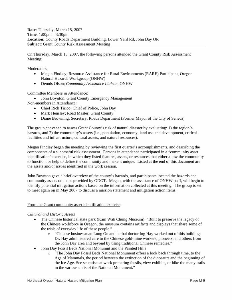
Date: Thursday, March 15, 2007 Time: 1:00pm – 3:30pm Location: County Roads Department Building, Lower Yard Rd, John Day OR Subject: Grant County Risk Assessment Meeting On Thursday, March 15, 2007, the following persons attended the Grant County Risk Assessment Meeting: Moderators:
• Megan Findley; Resource Assistance for Rural Environments (RARE) Participant, Oregon Natural Hazards Workgroup (ONHW)
• Dennis Olson; Community Assistance Liaison, ONHW Committee Members in Attendance:
• John Boynton; Grant County Emergency Management Non-members in Attendance:
• Chief Rich Tirico; Chief of Police, John Day • Mark Hensley; Road Master, Grant County • Diane Browning; Secretary, Roads Department (Former Mayor of the City of Seneca)
The group convened to assess Grant County’s risk of natural disaster by evaluating: 1) the region’s hazards, and 2) the community’s assets (i.e., population, economy, land use and development, critical facilities and infrastructure, cultural assets, and natural resources). Megan Findley began the meeting by reviewing the first quarter’s accomplishments, and describing the components of a successful risk assessment. Persons in attendance participated in a “community asset identification” exercise, in which they listed features, assets, or resources that either allow the community to function, or help to define the community and make it unique. Listed at the end of this document are the assets and/or issues identified in the work session. John Boynton gave a brief overview of the county’s hazards, and participants located the hazards and community assets on maps provided by ODOT. Megan, with the assistance of ONHW staff, will begin to identify potential mitigation actions based on the information collected at this meeting. The group is set to meet again on in May 2007 to discuss a mission statement and mitigation action items. From the Grant community asset identification exercise: Cultural and Historic Assets
• The Chinese historical state park (Kam Wah Chung Museum): “Built to preserve the legacy of the Chinese workforce in Oregon, the museum contains artifacts and displays that share some of the trials of everyday life of these people.”
o “Chinese businessman Lung On and herbal doctor Ing Hay worked out of this building. Dr. Hay administered care to the Chinese gold-mine workers, pioneers, and others from the John Day area and beyond by using traditional Chinese remedies.”
• John Day Fossil Beds National Monumnt and the Painted Hills o “The John Day Fossil Beds National Monument offers a look back through time, to the
Age of Mammals, the period between the extinction of the dinosaurs and the beginning of the Ice Age. See scientists at work preparing fossils, view exhibits, or hike the many trails in the various units of the National Monument.”
Northeast Oregon Natural Hazard Mitigation Plan Page M-9
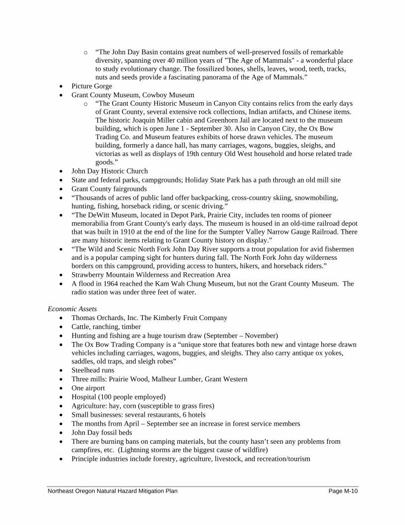
o “The John Day Basin contains great numbers of well-preserved fossils of remarkable diversity, spanning over 40 million years of "The Age of Mammals" - a wonderful place to study evolutionary change. The fossilized bones, shells, leaves, wood, teeth, tracks, nuts and seeds provide a fascinating panorama of the Age of Mammals.”
• Picture Gorge • Grant County Museum, Cowboy Museum
o “The Grant County Historic Museum in Canyon City contains relics from the early days of Grant County, several extensive rock collections, Indian artifacts, and Chinese items. The historic Joaquin Miller cabin and Greenhorn Jail are located next to the museum building, which is open June 1 - September 30. Also in Canyon City, the Ox Bow Trading Co. and Museum features exhibits of horse drawn vehicles. The museum building, formerly a dance hall, has many carriages, wagons, buggies, sleighs, and victorias as well as displays of 19th century Old West household and horse related trade goods.”
• John Day Historic Church • State and federal parks, campgrounds; Holiday State Park has a path through an old mill site • Grant County fairgrounds • “Thousands of acres of public land offer backpacking, cross-country skiing, snowmobiling,
hunting, fishing, horseback riding, or scenic driving.” • “The DeWitt Museum, located in Depot Park, Prairie City, includes ten rooms of pioneer
memorabilia from Grant County's early days. The museum is housed in an old-time railroad depot that was built in 1910 at the end of the line for the Sumpter Valley Narrow Gauge Railroad. There are many historic items relating to Grant County history on display.”
• “The Wild and Scenic North Fork John Day River supports a trout population for avid fishermen and is a popular camping sight for hunters during fall. The North Fork John day wilderness borders on this campground, providing access to hunters, hikers, and horseback riders.”
• Strawberry Mountain Wilderness and Recreation Area • A flood in 1964 reached the Kam Wah Chung Museum, but not the Grant County Museum. The
radio station was under three feet of water. Economic Assets
• Thomas Orchards, Inc. The Kimberly Fruit Company • Cattle, ranching, timber • Hunting and fishing are a huge tourism draw (September – November) • The Ox Bow Trading Company is a “unique store that features both new and vintage horse drawn
vehicles including carriages, wagons, buggies, and sleighs. They also carry antique ox yokes, saddles, old traps, and sleigh robes”
• Steelhead runs • Three mills: Prairie Wood, Malheur Lumber, Grant Western • One airport • Hospital (100 people employed) • Agriculture: hay, corn (susceptible to grass fires) • Small businesses: several restaurants, 6 hotels • The months from April – September see an increase in forest service members • John Day fossil beds • There are burning bans on camping materials, but the county hasn’t seen any problems from
campfires, etc. (Lightning storms are the biggest cause of wildfire) • Principle industries include forestry, agriculture, livestock, and recreation/tourism
Northeast Oregon Natural Hazard Mitigation Plan Page M-10
“Local economic development efforts in Grant County have focused on supporting and strengthening existing businesses, and the promotion of outdoor recreation. The growth of bed and breakfast establishments and specialty crafts companies may indicate a trend of developing market niches (JKA, 2006). Prairie City has two small wood products companies that focus on post and pole and juniper operations and a juniper/pine decorative furniture shop which sells “all the furniture we can make”, much of it through catalog sales (JKA, 2006). Strawberry Mountain Natural Beef opened for business in John Day in 2005, and currently comprises 12 ranchers from the John Day area. In addition, a bowstring manufacturing facility exists in Grant County’s new airport industrial park.”
Human Population
• BMW rally at the fairgrounds • Three major nursing homes: two in John Day, and one in Prairie City (Blue Mountain Nursing
Home) • Adult Foster Care: one in John Day, and one in West Branch • Summer and fall months see an increase in population for tourism and hunting • Prairie City has a very popular 4th of July Parade • Concentrations of persons (per day) can be found in the federal buildings, schools, and mills • The Forest Service has three buildings and houses about 200-300 employees (John Day). Prairie
City has about 175 persons employed through the Forest Service (?) • Camp Logan is an event where nearly 100 people convene and dress up in early 18th century
apparel. o Camp Logan was a military post close to present day Prairie City and was established in
1865 by the First Oregon Volunteers and then later occupied by the regular army. It remained until 1869. The historic site was located approximately 5 miles south of present day Prairie City.
o Portraying Camp Logan, Dixie Town and Grant County in the year 1867. o Camp Logan Days is sponsored by the Prairie City School History Club and 5th Grade
Class. o Each year, around the 3rd weekend in May, the camp is re-created by the Prairie City
School History Club. Students from the fifth grade class and any interested members of the community participate in a living history exhibit, open to the public.
• There are no housing developments in high hazard zones (that the group is aware of) • Portland State population projections:
o Certified population estimate, July 1, 2006: 7630 o Certified population estimate, July 1, 2005: 7685 o Population Change, 2005-2006: -55 o Percent Change, 2005-2006 -.7%
Environmental Assets
• Wilderness Areas; Malheur Forest • There’s a fault line that runs almost directly through the center of the valley (near where the river
runs). It’s been inactive for 5000 years. • There’s a small fault line under the football field by the high school. • Lightning storms and heavy winds increase the number of forest fires, building collapses, and
power outages • The John Day Valley has seen building damage from high winds and dust devils • Landslides occur in Mt. Vernon but they’re very small • There are occasional rock falls in Picture Gorge, but they affect an area that sees very little traffic
Northeast Oregon Natural Hazard Mitigation Plan Page M-11

• Forest fires would negatively affect the economic benefits that Grant County sees from hunting, tourism, and camping
• Grant County contains parts of four national forests. Infrastructure and Critical Facilities
• John Day has four (soon to be five) water towers (well-drilled) • There’s a 9-1-1 Center in John Day on Main St.; it’s also the John Day Police Department. City
Hall is attached. • The Sheriff’s Office and Jail are located in Canyon City • Oregon State Police is in a substation in the City of John Day • The Sheriff’s Office covers all city boundaries within the county. • Federal offices include the BLM, Forest Service, and Law Enforcement Office • Each small city has an ambulance, and there’s a hospital in John Day (Blue Mountain Hospital) • There’s a fire department in most cities, with the exception of Kimberly • The American Red Cross has a trailer full of equipment at the Mormon Church in John Day • There’s a Senior Center in John Day on Dayton St. • John Day has a wastewater treatment plant; Canyon City uses it. Prairie City has a treatment
plant with an irrigation system as well – as do Mt. Vernon and Long Creek • Mt. Vernon’s and John Day’s water treatment plants are near rivers, but this has never been a
problem • The backup dispatch for the 9-1-1 center is the sheriff’s department • The bridge system in Picture Gorge (if destroyed), would be a big problem • There are four ways in and out of the county (access and evacuation is not a huge problem) • There’s a river behind the jail that might be a problem. It’s a 47-bed facility with 12 employees,
five road officers, and an emergency manager. If it rose five feet, it could be a problem.
Northeast Oregon Natural Hazard Mitigation Plan Page M-12
Date: Tuesday, February 20, 2007 Time: 2:00pm – 5:00pm Location: Annex Conference Room, 1106 K Ave, La Grande OR Subject: Union County Risk Assessment Meeting On Tuesday, February 20, 2006, the following persons attended the Union County Risk Assessment Meeting: Moderators:
• Megan Findley; Resource Assistance for Rural Environments (RARE) Participant, Oregon Natural Hazards Workgroup (ONHW)
• Dennis Olson; Community Assistance Liaison, ONHW Committee Members in Attendance:
• Dara Salmon; Union County Emergency Services • Ray Hamann; La Grande RFPD • Rob Yuodeles; Eastern Oregon University • Michael P. Barry; Oregon Department of Transportation • Hanley Jenkins II; Union County Planning Department • JB Brock; Union County Emergency Services
The group convened to assess Union County’s risk of natural disaster by evaluating: 1) the region’s hazards, and 2) the community’s assets (i.e., population, economy, land use and development, critical facilities and infrastructure, cultural assets, and natural resources). Megan Findley began the meeting by reviewing the first quarter’s accomplishments, and describing the components of a successful risk assessment. Committee members participated in a “community asset identification” exercise, in which they listed features, assets, or resources that either allow the community to function, or help to define the community and make it unique. Listed at the end of this document are the assets and/or issues identified in the work session. Dara Salmon gave a brief overview of the county’s hazards, and committee members located the hazards and community assets on maps provided by ODOT. Megan, with the assistance of ONHW staff, will begin to identify potential mitigation actions based on the information collected at this meeting. The group is set to meet again on April 2, 2007 at 2:00 to discuss a mission statement and mitigation action items. From the Union community asset identification exercise: Economic Assets:
• Eastern Oregon University o Infrastructure o On-line services o Business-related programs o Student organizations
• Industrial Parks • Airport • Agricultural Base • Transportation of goods and services • Forest/timberlands
Northeast Oregon Natural Hazard Mitigation Plan Page M-13
• Boise Cascade • Government (collectively the largest employer in Union County) • RV manufacturing • Hospital • Tourism • Wal-Mart • Renewable energy: future initiatives in wind and biomass
Infrastructure and Critical Facilities
• Eastern Oregon University o Critical facilities centrally located in the city o Some HAZMAT (science building)
• Hospital: vulnerable to landslides • Roads & bridges – limited access points/routes • Excellent fire & police • Pipelines: natural gas & fuel oil • Union County airport • Union-Pacific railroad • I-84 / state highways • Government buildings / EOC dispatch, etc. • Schools and churches • Community Connections and Neighbor-to-Neighbor (food bank) • American Red Cross
Cultural & Historic Resources
• Older Eastern Oregon University buildings • Churches • Hot Lake • Archeological sites • Oregon Trail • Pioneer cemeteries • La Grande homes tour • Union Hotel • Elgin Opera House • Symphony / plays @ EOU • La Grande library (new) • Train depot • Historic bridges • Five museums
Environmental Assets
• Golf course: Buffalo Peak (City of Union) / La Grande Country Club (La Grande) • Timber and Forest land: 49% of the county’s land • Agricultural land • Reservoirs • River systems: Upper Grande Ronde watershed • Wildlife population • Natural forests / Eagle Cap Wilderness
Northeast Oregon Natural Hazard Mitigation Plan Page M-14
• Hunting & fishing • Geothermal • Mt. Emily public access • Sprout Springs / Anthony Lakes Ski Areas • Elgin – Joseph RR • Ladd Marsh • Wetlands
Human Population Assets
• Urban / wildland interface / rural residential areas are of concern • The Grande Ronde Hospital is in a dangerous location • Aging population • Eastern Oregon University:
o Shelter / ARC designated o Earthquake resistant building (new one) o Steam-power plant o Community of expertise / extensive partnerships
• Group homes / nursing homes • Seven incorporated cities within county boundaries • Tourists – hunting, skiing, camping areas • Boise Mills • Government headquarters (for multiple organizations) • Significant portion of the population is self-reliant • Industrial areas
Northeast Oregon Natural Hazard Mitigation Plan Page M-15
Date: Monday, March 19, 2007 Time: 2:00pm – 4:30pm Location: Meeting Hall Adjacent to County Courthouse, Enterprise OR Subject: Wallowa County Risk Assessment Meeting On Monday, March 19, 2007, the following persons attended the Wallowa County Risk Assessment Meeting: Moderators:
• Megan Findley; Resource Assistance for Rural Environments (RARE) Participant, Oregon Natural Hazards Workgroup (ONHW)
• Dennis Olson; Community Assistance Liaison, ONHW Committee Members in Attendance:
• Paul Karvoski; Wallowa County Emergency Management • Russ McMartin; Wallowa County Public Works
Non-members in Attendance: • J.R. Cook; Assistant Planning Director, Umatilla County
The group convened to assess Wallowa County’s risk of natural disaster by evaluating: 1) the region’s hazards, and 2) the community’s assets (i.e., population, economy, land use and development, critical facilities and infrastructure, cultural assets, and natural resources). Megan Findley began the meeting by reviewing the first quarter’s accomplishments, and describing the components of a successful risk assessment. Persons in attendance participated in a “community asset identification” exercise, in which they listed features, assets, or resources that either allow the community to function, or help to define the community and make it unique. Listed at the end of this document are the assets and/or issues identified in the work session. Participants located the hazards and community assets on maps provided by ODOT. Megan, with the assistance of ONHW staff, will begin to identify potential mitigation actions based on the information collected at this meeting. The group is set to meet again on in May 2007 to discuss a mission statement and mitigation action items. From the Wallowa community asset identification exercise: Hazard Vulnerabilities:
• The City of Enterprise has experienced flooding issues with both the Wallowa River and Prairie Creek
• The Grande Ronde River has caused flooding damage in the unincorporated town of Troy • The Imnaha River has damaged homes (several in 1997) and roads. Some homes have resultantly
been moved to higher ground. • Personal homes at the head of Wallowa Lake (South end) have been destroyed by the Wallowa
River. • The Imnaha Basin and Snake River Canyon have, historically, been the location of major fires. • Wallowa Lake State Park has not seen wildfire for 30-40 years. The Forest Service is working on
fuels reductions, but under the right conditions, the build-up of fuels will eventually ignite. Access to this area is extremely limited and presents a major vulnerability; with only one access road, summer tourists and residents may have difficulty evacuating in an emergency event.
Northeast Oregon Natural Hazard Mitigation Plan Page M-16
Infrastructure • The Dam at Wallowa Lake is over 100 years old and is in dire need of renovation. • Wallowa County has as new hospital, as of January 2007 • The subdivision of Imnaha River Woods (25 miles upriver of Imnaha, with 10-15 homes), has a
60ft flat bridge (made from a flat railroad-car) that residents must cross when entering or leaving their development. Should the Imnaha River flood, the bridge will likely fail.
• In the unincorporated community of Troy, there’s an old truss bridge that was originally built for vehicular traffic, but can currently sustain no more than foot traffic. This bridge connects the community to the school. Further south is a bridge that’s suitable for traffic. Should the truss bridge fail (from wear and tear or flooding), which it soon will, then residents will have to travel a fair distance to get to the school (i.e., drive south a for few miles, and then back north to the same latitude across the river).
• There are three bridges on highway 82 that ODOT is scheduled to replace. • There is a new justice center where all of the law-enforcement agencies are located. • There are high schools in Joseph, Enterprise, and Wallowa and elementary schools in each of the
cities, plus Troy. Lostine has the Providence Academy (religious school), which is where the old public school was located. Students from Imnaha attend Joseph’s schools; students from Troy attend Enterprise’s high school, and students from Lostine are split between Wallowa and Enterprise’s school systems.
• There are daily rock slides at Wallowa Lake on its west side; the county has done exploratory work to create an access route / right of way from the west, but private landowners have successfully prevented this from happening.
• Rock slides along the Imnaha River occur daily. Roads tend to be sited at the bottom of canyons for ease of construction
• Transmission lines run through the Hell’s Canyon Dam in the Imnaha Valley; a new fiber optic line will come up through the canyon from the town of Minam.
• Wallowa County has two airports: one in Enterprise (city airport), and one in Joseph (state airport)
• Enterprise, Wallowa, and Joseph have water treatment facilities; Enterprise is in the process of upgrading its facility; Lostine is working on building a new water system.
• Joseph’s water comes from wells and the Wallowa Lake. Human Population
• Alpine House in Joseph is a retirement home • Part of the old hospital in Enterprise will soon be a nursing home • There are some group homes for the mentally disabled in Enterprise. The old hospital may
eventually house Alzheimer’s patients (through a local nonprofit). • In the summer and fall months, Wallowa Lake sees a large amount of tourism; populations in
Joseph and Enterprise temporarily and significantly, increase. • There’s a hay station in Minam: the number of bale sales increases each year • There’s no cell phone coverage in several areas including Imnaha and Troy
Northeast Oregon Natural Hazard Mitigation Plan Page M-17

Meeting Minutes: Phase III ‘Action Identification’
Dates, Times, Locations: May 16, 2007: Baker County 9:00am – 12:00pm; Baker County Library May 16, 2007: Grant County 2:00pm – 4:00pm; Grant County Roads Department May 17, 2007: Union County 9:00am – 11:00am; 1106 K St. Commissioners’ Conference Room May 17, 2007: Wallowa County 2:00pm – 4:30pm; City of Enterprise City Hall
Subject: Baker, Grant, Union, and Wallowa County Action Identification Meetings Meeting Moderators:
• Megan Findley; Resource Assistance for Rural Environments (RARE) Participant, Oregon Natural Hazards Workgroup (ONHW)
• Dennis Olson; Community Assistance Liaison, ONHW • Krista Mitchell; Assistant Director, ONHW
Steering Committee Attendees:
Baker County • Jerry Boyd, Baker County 9-1-1 Dispatch Center • Laura Livingston, Baker County Planning Department • Ken Helgerson, Baker County Roads Department • Gary Timm, Baker County Emergency Management / Fire • Mark Bennett, Baker County Emergency Management • Noel Livingston, USDA Forest Service, Wallowa-Whitman
Grant County
• Peggy Gray, City of John Day • Jim McNellis, Grant County Sheriff’s Office • Gary Judd, Grant County Regional Airport
Union County
• Hanley Jenkins, County Planning Department • Michael P. Barry, Oregon Department of Transportation
Wallowa County
• Russ McMartin, County Public Works • Mike Hayward, Wallowa County Board of Commissioners • Paul Karvoski, Wallowa County Emergency Management • Lance Bailey, Wallowa County Planning Department
Each steering committee convened to review the regional mission and goals, and to choose mitigation action items for the region and Baker County. Megan Findley first presented the mission and goals to each steering committee. The mission, “Create a disaster resilient Northeast Oregon” was drafted by the Oregon Natural Hazards Workgroup and agreed upon by all committee members. Goals were developed in a collaborative effort between ONHW, the RARE Participant, and county steering committees. ONHW developed a set of draft goals that were based on goals from an existing regional economic development strategy. The strategy was prepared by Northeast Oregon Economic Development District’s (NEOEDD), a public organization that offers business assistance, technical assistance, and planning to Baker, Union, and Wallowa Counties.
Northeast Oregon Natural Hazard Mitigation Plan Page M-18

In their ‘Northeast Oregon Comprehensive Economic Development Strategy,’ NEOEDD lists the following goals:
Goal 1: Ensure that the regional economy is disaster resilient Goal 2: Protect the citizens of the region through education and outreach efforts. Goal 3: Maintain and enhance organizational and community capacity Goal 4: Reduce the impact of natural hazards on regional and community infrastructure.
The following table illustrates how the economic strategy goals were revised by ONHW to reflect mitigation principles. Table 3.1 Relation between Economic Strategy and Multi-Jurisdictional Plan goals.
Comprehensive Economic Development Strategy Goals
Community Asset or Vulnerability Mitigation Plan Goal
Diversify and Expand the Economy Local Economy Ensure that the regional economy is disaster resilient
Maintain and Expand Workforce Training and Educational Opportunities for All Ages Citizens/Workforce Protect the citizens of the region through
education and outreach efforts
Maintain and Enhance Organizational and Community Capacity Community Capacity Maintain and Enhance Organizational and
Community Capacity
Develop and Maintain Necessary Infrastructure Critical Infrastructure
Reduce the impact of natural hazards on critical regional and community infrastructure
Source: ONHW, 2006
Regional economic development goals are relevant to natural hazard mitigation because they address important community assets and vulnerabilities that are susceptible to natural hazards. Further, NEOEDD’s Economic Development Strategy goals have been approved by representatives from three of the four counties in the Region 7 Natural Hazards Mitigation Plan. Adopting already-agreed upon goals aligns with FEMA’s requirement to implement the mitigation plan through existing plans and programs. Megan Findley, with input from each Steering Committee, made small modifications to the wording and organization of ONHW’s proposed goal statements. She additionally added objective statements to describe the intended outcomes of goals. Megan then presented a set of thirty-one action items for committees’ review. She asked to receive votes for approval/disapproval, as well as nominations for the coordinating and partnering organizations. Committee members in each county reviewed all 31 actions and approved each action’s addition to the plan. Megan recorded various suggestions as to the wording of actions, and/or the pairing of similar action items. Following the meeting, Megan contacted individual steering committee members for their further assistance in developing more thoroughly-conceived action items. She additionally contacted the steering committee members who were unable to attend meetings, to gather their review of the plan’s mission, goals, and action items.
Northeast Oregon Natural Hazard Mitigation Plan Page M-19

Meeting Minutes: Phase IV ‘Plan Implementation and Maintenance’
Dates, Times, Locations: July 10, 2007: Baker County 9:00am – 10:30am; Baker County Courthouse July 12, 2007: Union County 9:00am – 10:30am; 1106 K St. Commissioners’ Conference Room July 28, 2007: Wallowa County 1:00pm – 2:00pm; Wallowa County Courthouse
Subject: Baker, Grant, Union, and Wallowa County Plan Implementation and Maintenance Meetings
Meeting Moderators: • Megan Findley; Resource Assistance for Rural Environments (RARE) Participant, Oregon
Natural Hazards Workgroup (ONHW) • Dennis Olson; Community Assistance Liaison, ONHW
Steering Committee Attendees:
Baker County • Mark Bennett; Baker County Emergency Management • Laura Livingston, Baker County Planning Department • Ken Helgerson; Baker County Roads Department • Cory Parsons; Baker County Oregon State University Extension Office • Warren Thompson; Baker County Sheriff • Jerry Boyd; Baker County Dispatch
Union County
• Dara Salmon; Union County Emergency Services • Rob Yuodeles; Eastern Oregon University • Michael P. Barry; Oregon Department of Transportation • J.B. Brock; Union County Emergency Services
Wallowa County
• Russ McMartin, County Public Works • Paul Karvoski, Wallowa County Emergency Management • Lance Bailey, Wallowa County Planning Department
Each group convened to review the plan implementation and maintenance requirements. Megan Findley presented information describing 1) how the plan should be maintained and updated; 2) the process for implementing an action item; 3) methods and ideas for continuing to engage public participation; and 4) potential funding sources. Each group chose a convener for future meetings, and discussed additional needs/concerns. Each Steering Committee chose to meet again in mid - August to review the draft plan as a group. Megan Findley agreed to attend this meeting to help members better understand the plan’s components and review process. Grant County did not participate in a fourth Steering Committee Meeting due to scheduling conflicts and time / resource constraints Instead, Megan met individually with the following persons on two occasions. At these meetings, Megan discussed action items, as well as implementation & maintenance procedures.
• Valerie Luttrell • Judi McNellis • Stanley Horrell • Gary Judd
• Jim McNellis • T.R. Hilton • Peggy Gray • Mark Webb
Northeast Oregon Natural Hazard Mitigation Plan Page M-20

Northeast Oregon Natural Hazard Mitigation Plan Page M-21
Stakeholder Interviews 2006-07 Northeast Oregon Natural Hazards Mitigation Plan
Stakeholder Interview Description Stakeholder interviews allowed communities to collect information on critical issues, needs, current activities, and opportunities for collaboration related to natural hazard mitigation. A “stakeholder” could be a neighboring community, agency, business, academic institution, non-profit, or other interested party. Involving stakeholder input in the planning process:
• Built ownership and community support for the plan; • Helped to ensure that the final plan reflected community’s priorities; and • Helped to foster the collaboration that was necessary for successful plan implementation
and maintenance.
The language of the Disaster Mitigation Act of 2000 requires that the planning effort provide an opportunity for the public to be involved in developing the plan. Inviting stakeholders to participate in the interviews provided this opportunity.
Stakeholder interviews provided input on: the risk assessment, potential action items, and existing plans related to natural hazard mitigation. Information provided by stakeholders additionally helped identify and foster potential partnerships. The following persons/groups were interviewed during the 2006-2007 planning process:
o American Red Cross, La Grande: Gene Paul o Baker County Consolidated 9-1-1 Dispatch Center: Jerry Boyd, Director o Baker County Emergency Management: Mark Bennett o Bureau of Land Management, Baker City: Melinda Martin o City of Baker City: Evan MacKenzie, Planning Director o City of Cove: Donna Lewis, City Administrator o City of Cove: Richard Thew, Mayor o City of Enterprise: Michelle Young and Larry Estes o City of Greenhorn: Fran Villwock o City of Halfway: Gordon Kaesemeyer, Mayor and Page Frederickson, Public Works
Director o City of Island City, Judy A. Ryss o City of John Day, Peggy Gray, City Manager o City of La Grande, Liz Hill o City of Richland: Gerry Stevens, City Administrator o City of Sumpter: Toni Thompson, City Administrator o City of Union: Jeff Wise, City Administrator o Community Connection of Baker County, Mary Jo Carpenter o Community Connections Senior Center, La Grande o Eastern Oregon Head Start, Marilyn Herbst o Eastern Oregon University: Rob Yuodelis, Director of Environmental Health and Safety o Elgin Rural Fire Department, Patrick McDonald o Grande Ronde Hospital, Norman Kerr
Northeast Oregon Natural Hazard Mitigation Plan Page S-1

o Grant County, Mark Webb, County Judge o Greater Eastern Oregon Development Corporation (GEODC), Sondra Lino o Northeast Oregon Economic Development District: Lisa Dawson o Northeast Oregon Housing Authority, Dale Inslee o Oregon Department of Forestry, Baker City: Keith Schollenberger o Oregon Department of Forestry, La Grande: Jaime Knight o Union County Chamber of Commerce: Judy Loudermilk, Executive Director o Union County Emergency Services: Dara Salmon o Union County Planning Department: Hanley Jenkins, II, Director o Wallowa County Emergency Services: Paul Karvoski o Wallowa County Planning Department: Lance Bailey, Director o Wallowa Resources, Nils Christoffersen o Wallowa Soil and Water Conservation District, Cynthia Warnock
Stakeholder Interview Methodology I) Megan Findley conducted 19 of the 35 stakeholder interviews; four of the 19 were conducted
via email, and 15 were conducted in-person. Each organization received the following list of questions.
General Questions
1. From your organization’s perspective, what hazard(s) pose the greatest threat to the community and why?
2. Does your organization maintain information or data on the impact of previous disasters? How so?
Community Vulnerability
Population 3. Are there certain populations within the community that might be at greater risk? Please
explain… 4. What organizations in the community provide services to special populations in the
community?
Economic Assets 5. How might natural hazards impact the local economy? 6. Which businesses would be significantly impacted by the temporary loss of utilities?
Cultural and Historic 7. Are there cultural or historic resources that are important to the community? What are they?
Critical Facilities and Infrastructure 8. What critical facilities and infrastructure does your community rely on to function?
Natural Resources 9. Could natural hazards impact environmental resources in your community? If so, how?
Land Use and Development
Northeast Oregon Natural Hazard Mitigation Plan Page S-2
10. Do you foresee population growth or change in your community? If so, where? 11. Are there existing developments in areas you think are subject to natural hazards?
a. What are the current and future development trends?
Resources/Activities 12. Does your organization currently work in natural hazard mitigation? If yes, how? 13. What role can your organization play in reducing risk in your community? 14. Does your organization have any plans or policies that affect local residents, the economy,
natural resources, or land use and development?
Action Items 15. What activities do you think your community should take to reduce risk and prevent loss
from future natural hazard events? (If you had the $, how would you spend it?) a. Are there any activities your organization could do to reduce risk?
16. In what ways would like to see agencies, organizations or individuals in NE Oregon participate and coordinate to reduce risk from natural hazards? a. What agencies or organizations in the community or the region do you think should be
involved in risk reduction activities in this community? 17. Can you think of other people or organizations we should contact?
II) Sixteen interviews were completed by mail. Adrian Albrich, the Risk Management
Consultant for Eastern Oregon City County Insurance Services, distributed the following memo to all remaining cities, counties, and organizations in Region 7.
Memo To: Northeast Oregon Cities
From: Oregon Natural Hazard Workgroup at the University of Oregon
Date: April 25, 2007
Re: Northeast Oregon Regional Natural Hazard Mitigation Plan
Purpose
The purpose of this memo is to provide your community with a brief background on a regional natural hazard mitigation planning effort that is taking place in Northeast Oregon. The memo also serves as a data collection tool to gather information about natural hazards from your community’s perspective.
Background
Last fall, Baker, Grant, Union and Wallowa Counties began a planning process to develop a regional natural hazard mitigation plan. The purpose of the plan is (1) to identify the natural hazard issues that the region faces and (2) to identify projects and activities the communities can engage in to reduce the impact of natural hazards in the future. Cities can sign on to the regional plan by answering the following questions, identifying community specific projects, and adopting the regional plan. Participating in the planning process and adopting the plan makes the community eligible for pre and post-disaster funding sources.
Northeast Oregon Natural Hazard Mitigation Plan Page S-3
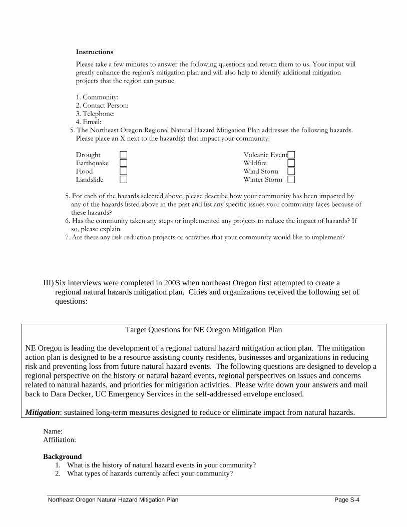
Instructions
Please take a few minutes to answer the following questions and return them to us. Your input will greatly enhance the region’s mitigation plan and will also help to identify additional mitigation projects that the region can pursue. 1. Community: 2. Contact Person: 3. Telephone: 4. Email:
5. The Northeast Oregon Regional Natural Hazard Mitigation Plan addresses the following hazards. Please place an X next to the hazard(s) that impact your community. Drought Earthquake Flood Landslide
Volcanic Event Wildfire Wind Storm Winter Storm
5. For each of the hazards selected above, please describe how your community has been impacted by
any of the hazards listed above in the past and list any specific issues your community faces because of these hazards?
6. Has the community taken any steps or implemented any projects to reduce the impact of hazards? If so, please explain.
7. Are there any risk reduction projects or activities that your community would like to implement?
III) Six interviews were completed in 2003 when northeast Oregon first attempted to create a
regional natural hazards mitigation plan. Cities and organizations received the following set of questions:
Target Questions for NE Oregon Mitigation Plan NE Oregon is leading the development of a regional natural hazard mitigation action plan. The mitigation action plan is designed to be a resource assisting county residents, businesses and organizations in reducing risk and preventing loss from future natural hazard events. The following questions are designed to develop a regional perspective on the history or natural hazard events, regional perspectives on issues and concerns related to natural hazards, and priorities for mitigation activities. Please write down your answers and mail back to Dara Decker, UC Emergency Services in the self-addressed envelope enclosed. Mitigation: sustained long-term measures designed to reduce or eliminate impact from natural hazards.
Name: Affiliation: Background
1. What is the history of natural hazard events in your community? 2. What types of hazards currently affect your community?
Northeast Oregon Natural Hazard Mitigation Plan Page S-4
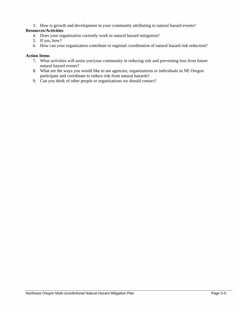
3. How is growth and development in your community attributing to natural hazard events? Resources/Activities
4. Does your organization currently work in natural hazard mitigation? 5. If yes, how? 6. How can your organization contribute to regional coordination of natural hazard risk reduction?
Action Items
7. What activities will assist you/your community in reducing risk and preventing loss from future natural hazard events?
8. What are the ways you would like to see agencies, organizations or individuals in NE Oregon participate and coordinate to reduce risk from natural hazards?
9. Can you think of other people or organizations we should contact?
Northeast Oregon Multi-Jurisdictional Natural Hazard Mitigation Plan Page S-5
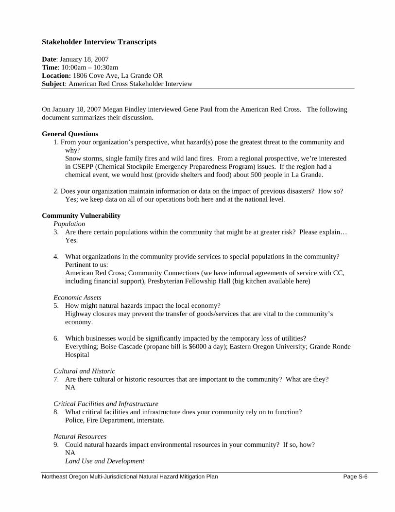
Stakeholder Interview Transcripts Date: January 18, 2007 Time: 10:00am – 10:30am Location: 1806 Cove Ave, La Grande OR Subject: American Red Cross Stakeholder Interview On January 18, 2007 Megan Findley interviewed Gene Paul from the American Red Cross. The following document summarizes their discussion. General Questions
1. From your organization’s perspective, what hazard(s) pose the greatest threat to the community and why? Snow storms, single family fires and wild land fires. From a regional prospective, we’re interested in CSEPP (Chemical Stockpile Emergency Preparedness Program) issues. If the region had a chemical event, we would host (provide shelters and food) about 500 people in La Grande.
2. Does your organization maintain information or data on the impact of previous disasters? How so?
Yes; we keep data on all of our operations both here and at the national level. Community Vulnerability
Population 3. Are there certain populations within the community that might be at greater risk? Please explain…
Yes. 4. What organizations in the community provide services to special populations in the community?
Pertinent to us: American Red Cross; Community Connections (we have informal agreements of service with CC, including financial support), Presbyterian Fellowship Hall (big kitchen available here)
Economic Assets 5. How might natural hazards impact the local economy?
Highway closures may prevent the transfer of goods/services that are vital to the community’s economy.
6. Which businesses would be significantly impacted by the temporary loss of utilities?
Everything; Boise Cascade (propane bill is $6000 a day); Eastern Oregon University; Grande Ronde Hospital
Cultural and Historic 7. Are there cultural or historic resources that are important to the community? What are they?
NA
Critical Facilities and Infrastructure 8. What critical facilities and infrastructure does your community rely on to function?
Police, Fire Department, interstate.
Natural Resources 9. Could natural hazards impact environmental resources in your community? If so, how?
NA Land Use and Development
Northeast Oregon Multi-Jurisdictional Natural Hazard Mitigation Plan Page S-6

10. Do you foresee population growth or change in your community? If so, where? “Absolutely not.”
11. Are there existing developments in areas you think are subject to natural hazards?
NA a. What are the current and future development trends?
NA Resources/Activities
12. Does your organization currently work in natural hazard mitigation? If yes, how? No, the Red Cross typically works in response.
13. What role can your organization play in reducing risk in your community?
Respond to emergencies
14. Does your organization have any plans or policies that affect local residents, the economy, natural resources, or land use and development? No. We don’t influence decision making, land use or development.
Action Items
15. What activities do you think your community should take to reduce risk and prevent loss from future natural hazard events? (If you had the $, how would you spend it?) 1) Work on wildfire (fuels reductions; insect abatements to reduce the fuel loads) 2) Conduct earthquake surveys to strengthen predictive information 3) Improve winter storm warning devices. (To their detriment, information is not always accurate for travelers coming from The Dalles or Ontario.)
a. Are there any activities your organization could do to reduce risk?
NA; we’re responders.
16. In what ways would like to see agencies, organizations or individuals in NE Oregon participate and coordinate to reduce risk from natural hazards? Coordinate efforts when possible; everyone’s working on their own, trying to fight for the same dollar.
a. What agencies or organizations in the community or the region do you think should be involved in risk reduction activities in this community? Everyone
17. Can you think of other people or organizations we should contact?
Agricultural Resources Center Lab in Union; Oregon State Extension Services
Northeast Oregon Multi-Jurisdictional Natural Hazard Mitigation Plan Page S-7
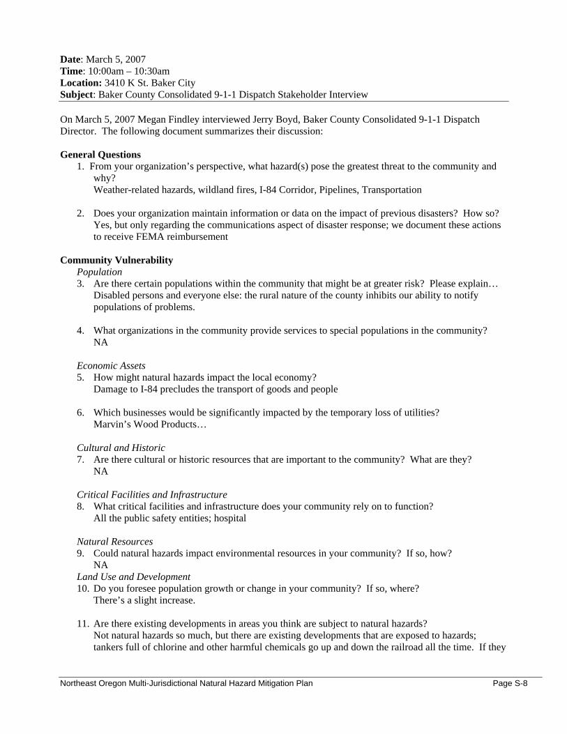
Date: March 5, 2007 Time: 10:00am – 10:30am Location: 3410 K St. Baker City Subject: Baker County Consolidated 9-1-1 Dispatch Stakeholder Interview On March 5, 2007 Megan Findley interviewed Jerry Boyd, Baker County Consolidated 9-1-1 Dispatch Director. The following document summarizes their discussion: General Questions
1. From your organization’s perspective, what hazard(s) pose the greatest threat to the community and why? Weather-related hazards, wildland fires, I-84 Corridor, Pipelines, Transportation
2. Does your organization maintain information or data on the impact of previous disasters? How so?
Yes, but only regarding the communications aspect of disaster response; we document these actions to receive FEMA reimbursement
Community Vulnerability
Population 3. Are there certain populations within the community that might be at greater risk? Please explain…
Disabled persons and everyone else: the rural nature of the county inhibits our ability to notify populations of problems.
4. What organizations in the community provide services to special populations in the community?
NA
Economic Assets 5. How might natural hazards impact the local economy?
Damage to I-84 precludes the transport of goods and people
6. Which businesses would be significantly impacted by the temporary loss of utilities? Marvin’s Wood Products…
Cultural and Historic 7. Are there cultural or historic resources that are important to the community? What are they?
NA
Critical Facilities and Infrastructure 8. What critical facilities and infrastructure does your community rely on to function?
All the public safety entities; hospital
Natural Resources 9. Could natural hazards impact environmental resources in your community? If so, how?
NA Land Use and Development 10. Do you foresee population growth or change in your community? If so, where?
There’s a slight increase.
11. Are there existing developments in areas you think are subject to natural hazards? Not natural hazards so much, but there are existing developments that are exposed to hazards; tankers full of chlorine and other harmful chemicals go up and down the railroad all the time. If they
Northeast Oregon Multi-Jurisdictional Natural Hazard Mitigation Plan Page S-8

derail and rupture (which has happened before), we would need to evacuate schools, this facility, the hospital, and an eldercare facility nearby.
a. What are the current and future development trends?
NA
Resources/Activities 12. Does your organization currently work in natural hazard mitigation? If yes, how?
Not directly
13. What role can your organization play in reducing risk in your community? If we had reverse 9-11 facilities, we could help with warning the community.
14. Does your organization have any plans or policies that affect local residents, the economy, natural
resources, or land use and development? NA
Action Items
15. What activities do you think your community should take to reduce risk and prevent loss from future natural hazard events? (If you had the $, how would you spend it?) We need a better means of notifying the public; Beacon is the notification system (current one), and it can be used for any major event. Beacon requires the dispatch center to call a community contact, who then puts signs up around the community. These signs let people know there’s some kind of problem, and it directs people to the dispatch website and/or radio for information. This is all dependent on people noticing when the e-signs are up and/or taking the initiative listen to the radio. A reverse-notification system would automatically call phone numbers in the district, thereby tremendously enhancing the dispatch’s ability to notify, and the public’s ability to respond.
a. Are there any activities your organization could do to reduce risk?
NA (see above)
16. In what ways would you like to see agencies, organizations or individuals in NE Oregon participate and coordinate to reduce risk from natural hazards? NA
a. What agencies or organizations in the community or the region do you think should be
involved in risk reduction activities in this community? NA
17. Can you think of other people or organizations we should contact?
NA
Northeast Oregon Multi-Jurisdictional Natural Hazard Mitigation Plan Page S-9

Date: February 22, 2007 Time: NA Location: NA Subject: Baker County Emergency Management Stakeholder Interview On February 22, 2007 Mark Bennett, Baker County Emergency Manager/Planning Director completed the following survey: General Questions
1. From your organization’s perspective, what hazard(s) pose the greatest threat to the community and why? See County Hazards Analysis and Community Wildfire Protection Plan
2. Does your organization maintain information or data on the impact of previous disasters? How so?
Limited historical data Community Vulnerability
Population 3. Are there certain populations within the community that might be at greater risk? Please explain…
Special Needs, Seniors--- Lack of public transportation system, no county TV or Radio stations for alert and warning, vast geographical expanse, lack of rural responders (especially EMS providers) lack of special needs/seniors locations pre-identified. Special needs buses extremely limited and located in Baker City.
4. What organizations in the community provide services to special populations in the community?
Community Connections, Step Forward, (Baker City)
Economic Assets 5. How might natural hazards impact the local economy?
The county’s economy is principally based upon agriculture with support from tourism. Any interruption of either area (and a natural hazard will more than likely impact both areas) will result in direct impact to the economy. Interruptions to the natural gas system will result in Baker City’s inability to heat residents’ homes and businesses. Interruptions could be the result of seismic activity, fires, flooding or landslides. Fires, flooding, volcanic, or seismic activity can severely interrupt agriculture in Baker County, impacting the production, storage and transportation of the particular products.
6. Which businesses would be significantly impacted by the temporary loss of utilities?
Hotels, motels, restaurants all serving the tourism industry: The outgrowth would be that that segment would go elsewhere.
Cultural and Historic 7. Are there cultural or historic resources that are important to the community? What are they?
Each community in Baker County has identified significant cultural and historical resources: Baker City: Historic Baker City, Chinese Cemetery, St. Anthony’s Cathedral, Oregon Trail Interpretive Center, Phillips Res. Baker City Watershed, The Oregon Trail Haines: Rock Creek Power Plant, Phillips Park, Elkhorn Wilderness Halfway: Cornicopia, Brownlee Res. , Eagle Cap Wilderness Huntington: Brownlee Res. Richland: Brownlee Res.
Northeast Oregon Multi-Jurisdictional Natural Hazard Mitigation Plan Page S-10
Sumpter: Sumpter Dredge, Phillips Res., Sumpter Valley RR, Sumpter Dredge Tailings Park, McCulley Forks Watershed Unity: Unity Dam, Monument Rock Wilderness
Critical Facilities and Infrastructure 8. What critical facilities and infrastructure does your community rely on to function?
I-84, Idaho Power Grid, Union-Pacific NW Rail Corridor, Williams Natural Gas Pipelines, Chevron Pipelines Mason Dam, Unity Dam, Wolfe Creek Res., Thief Valley Res.
Natural Resources 9. Could natural hazards impact environmental resources in your community? If so, how?
Yes. Wildfires, flooding, seismic activity, landslides, and volcanic activity can lead to loss of timber, vegetation, and water resources, and the destruction of ecosystems.
Land Use and Development 10. Do you foresee population growth or change in your community? If so, where?
No. Portland State Univ. has projected a fairly level population until 2025 11. Are there existing developments in areas you think are subject to natural hazards?
Yes, (Fire) they are identified in the Community Wildfire Protection Plan. (Localized flooding) Halfway and Pine Cr. /Wingville.
a. What are the current and future development trends?
Not a significant change in the land use mosaic. Resources/Activities
12. Does your organization currently work in natural hazard mitigation? If yes, how? We work in partnership with NRCS, SWCD, USACE and USDA Farm Services Agency.
13. What role can your organization play in reducing risk in your community?
Community outreach, education, preparedness
14. Does your organization have any plans or policies that affect local residents, the economy, natural resources, or land use and development? No.
Action Items
15. What activities do you think your community should take to reduce risk and prevent loss from future natural hazard events? (If you had the $, how would you spend it?) Stream Mitigation efforts in the Halfway/Pine Creek area
a. Are there any activities your organization could do to reduce risk?
Watershed enhancement, stream stabilization
16. In what ways would like to see agencies, organizations or individuals in NE Oregon participate and coordinate to reduce risk from natural hazards? More on-the-ground assistance from Federal agencies
a. What agencies or organizations in the community or the region do you think should be
involved in risk reduction activities in this community? The cities, the county, directly-affected state agencies
Northeast Oregon Multi-Jurisdictional Natural Hazard Mitigation Plan Page S-11

17. Can you think of other people or organizations we should contact?
NA
Northeast Oregon Multi-Jurisdictional Natural Hazard Mitigation Plan Page S-12
Date: February 28, 2007 Time: 2:30pm – 3:30pm Location: 3285 11th St, Baker City OR Subject: Bureau of Land Management, Baker City Stakeholder Interview On February 28, 2007 Megan Findley interviewed Melinda Martin from the Bureau of Land Management in Baker City, OR. The following document summarizes their discussion. General Questions
18. From your organization’s perspective, what hazard(s) pose the greatest threat to the community and why? From a fuels management perspective: wildfire (excessive fuels buildups)
19. Does your organization maintain information or data on the impact of previous disasters? How so?
Yes, we maintain a database on past fires that includes information about the extent, structures involved, and when it happened (among additional information).
Community Vulnerability
Population 20. Are there certain populations within the community that might be at greater risk? Please explain…
Older persons and asthmatics are more susceptible to the dangers of wildfire smoke. More generally, populations within the wildland/urban interfaces are at great risk to disaster than others.
21. What organizations in the community provide services to special populations in the community?
The BLM’s ‘community’ is fairly large, but from the wildfire perspective: the forest service, BLM, rural (and volunteer) fire departments The Fire Defense Board (Gary Timm) coordinates wildland fire trainings for all the volunteer fire departments. ODF – National Fire Plan
Economic Assets 22. How might natural hazards impact the local economy?
Wildfires cause timber income losses. In the Southern Oregon areas (Baker County and south), fires contribute to the loss of pasture lands.
23. Which businesses would be significantly impacted by the temporary loss of utilities?
Timber mills (and any other industries supporting the local economy).
Cultural and Historic 24. Are there cultural or historic resources that are important to the community? What are they?
Oregon Trail; old mining sites, old town sites (Auburn = old mining town site) Balm Creek – being cleaned from mining leftovers
Critical Facilities and Infrastructure 25. What critical facilities and infrastructure does your community rely on to function?
Gas pipelines and power lines (which we, in particular, have to look out for)
Natural Resources 26. Could natural hazards impact environmental resources in your community? If so, how?
Wildfire affects timber and forest stands in addition to water quality, air quality, and wildlife habitat.
Northeast Oregon Multi-Jurisdictional Natural Hazard Mitigation Plan Page S-13
Land Use and Development 27. Do you foresee population growth or change in your community? If so, where?
Yes. The area seems to be growing, especially in the wildland-urban interface areas. Also, housing costs have increased fairly recently
28. Are there existing developments in areas you think are subject to natural hazards?
Wood Tick village (one of those villages on the edge of developments) and WUI zones (identified in the CWPP)
a. What are the current and future development trends? (See above)
Resources/Activities
29. Does your organization currently work in natural hazard mitigation? If yes, how? Yes, we do fuels reduction projects both within and outside of WUI zones
30. What role can your organization play in reducing risk in your community?
We help to develop mitigation plans for the CWPP’s; we have efficient wildland fire suppression capabilities, and we have fuels reduction projects on our lands and adjacent lands. We can work to educate landowners and community members on fire-prevention practices.
31. Does your organization have any plans or policies that affect local residents, the economy, natural
resources, or land use and development? From a fuels standpoint, we have plans for doing fuels reduction projects; this affects the local economy because local people are getting the contracts We manage smoke so-as not to impact the populations (but it does affect folks if it’s not managed right).
Action Items
32. What activities do you think your community should take to reduce risk and prevent loss from future natural hazard events? (If you had the $, how would you spend it?) With extra money, we would continue to do fuels reduction projects, and work to create fuels breaks in wildland-urban interface areas. We could also do more education with landowners on risk-reduction practices.
a. Are there any activities your organization could do to reduce risk?
Same as above
33. In what ways would you like to see agencies, organizations or individuals in NE Oregon participate and coordinate to reduce risk from natural hazards? If there was a way that we could involve more people (for education purposes), that would be great.
a. What agencies or organizations in the community or the region do you think should be
involved in risk reduction activities in this community? BLM, forest service, ODF, volunteer fire departments and organizations, counties and cities
34. Can you think of other people or organizations we should contact?
Northeast Oregon Multi-Jurisdictional Natural Hazard Mitigation Plan Page S-14
US Forest Service (and anyone involved in the CWPP); Jay Rasmussen (Forest Service for La Grande District); Steve Hawkins (Burnt Powder Fire Zone); Enterprise Ranger District – Jenny Reinhart Ken Rockwell, “Fuels Forrester,” works with the Wallowa-Whitman National Forest; he works in Baker at the Supervisor’s Office (Post-Office Federal Building) Fire Management Office 541-523-1262
Additional Comments: **We’d like maps that include existing roads and access abilities for both private and public roads. An accurate representation of transportation systems is needed.
Northeast Oregon Multi-Jurisdictional Natural Hazard Mitigation Plan Page S-15
Memo To: Community Stakeholders in Northeast Oregon From: Oregon Natural Hazard Workgroup at the University of Oregon Date: April 24, 2007 Re: Northeast Oregon Regional Natural Hazard Mitigation Plan
Purpose
The purpose of this memo is to provide your organization with a brief background on a regional natural hazard mitigation planning effort that is taking place in Northeast Oregon. The memo also serves as a data collection tool to gather information about natural hazards from your organization’s perspective.
Background
Last fall, Baker, Grant, Union and Wallowa Counties began a planning process to develop a regional natural hazard mitigation plan. The purpose of the plan is (1) to identify the natural hazard issues that the region faces and (2) to identify projects and activities the communities can engage in to reduce the impact of natural hazards in the future. This mitigation planning process is greatly enhanced when special districts and community organizations are involved and can provide additional information.
Instructions
Please take a few minutes to answer the following questions and return them to us by Wednesday, May 2nd. Your input will greatly enhance the region’s mitigation plan and will also help to identify additional mitigation projects that the region can pursue. 1. Organization: City of Baker City 2. Contact Person: Evan MacKenzie, Planning Director 3. Telephone: 541-524-2030 4. Email: [email protected] 5. The Northeast Oregon Regional Natural Hazard Mitigation Plan addresses the following hazards. Please replace the box(es) with Xs next to the hazard(s) that your organization is most concerned about. Drought Wildfire Winter Storm 6. Briefly describe why these hazards are of concern for your organization. Please be as specific as possible. Weather-related emergencies are the most likely to affect Baker City and Baker County. We are prone to extreme temperatures both in the summer and winter. Harsh winters bring lots of snow and cold, and force closure of Interstate 84 on a regular basis. A prolonged heavy winter storm could cut off our supply chain. A heavy winter might also lead to a wet spring, which has the potential to lead to heavy forest growth. In our typically dry summers, that means a lot of fuel for wildfires. If the summer is more dry than normal, this danger increases. If the winter was very dry, like the most recent winter, we may also face the possibility of dry forests. We do not have a large urban/forest interface, but the possibility exists for fire to come down from the hills none the less. A forest fire in the City’s (drinking) watershed would impact our water supply drastically. We have numerous diversions to utilize depending on the location of a fire, but typically in the summer months we’re using water from most of our sources. Drought would also be a concern as Goodrich Reservoir may not fill in dry years-low snow quantities leave us with little snow melt going into the reservoir for spring.
Northeast Oregon Multi-Jurisdictional Natural Hazard Mitigation Plan Page S-16
7. Please describe how your organization has been impacted by any of the hazards listed above in the past? (For example - loss of power, closure of transportation systems, damage to property, etc. Please be as specific as possible). Interstate 84 is closed on a regular basis in the winter due to heavy snow. We have not been affected recently by any wildfires that came close to town. We did have an irrigation ditch break above town a couple years ago, sending water and mud several feet deep into a residential area below.
8. What role can your organization play in reducing risk from natural hazards in your community? We have no control over the weather. All we can do is ask the local population to make sure they have enough supplies in the winter in case the interstate is closed for an extended period. Summer heat waves are not unusual here. Most people exercise enough common sense to have at least minimal preparations for extreme weather. Many people, even in town, have four-wheel-drive vehicles, ATVs and snowmobiles than can be used for winter emergencies. The City can encourage residents to have enough food and fuel on hand to get through big winter storms.
9. Are there any risk reduction projects that your organization would like to implement that would directly benefit your organization, your facilities or your employees?
Many City staff have been through numerous Emergency Management training exercises. These classes and exercises should be continued to keep us all prepared. 10. Are there any risk reduction projects that your organization would like to see implemented that would benefit the community in general? A Watershed Fuel Reduction program is necessary to continue to remove fire fuel from our watershed in order to maintain our water supply for the community. Should a fire erupt in the watershed, it would have catastrophic consequences.
Northeast Oregon Multi-Jurisdictional Natural Hazard Mitigation Plan Page S-17
Date: January 10, 2007 Time: 9:00am Location: City Hall, Cove OR Subject: Stakeholder Interview with the City of Cove, OR On January 18, 2007 Megan Findley interviewed Donna Lewis, City of Cove Administrator. The following summarizes their discussion:
1. From your organization’s perspective, what hazard(s) pose the greatest threat to the community and why? Wind storms, trees on houses; not too many problems with flooding; The hydro plant is vulnerable drought (because it needs water to run). The city is contracted to make a certain amount of power until 2009. It cannot always meet its quota, which is a financial concern above all else. Wildfire is always a concern, but there’s little history of it. *Non – wildland fires have twice destroyed the town (its hotels and restaurants); there used to be prunes in the area (cherries now), and fire was caused by the prune dryers Mill creek comes through town – but flooding is not an issue
2. Does your organization maintain information or data on the impact of previous disasters? How so?
No Community Vulnerability
Population 3. Are there certain populations within the community that might be at greater risk? Please explain…
Cove has a number of retired persons in residence. Any disaster would be particularly difficult for this segment of the population.
4. What organizations in the community provide services to special populations in the community?
• School children have community hour requirements; typically, they provide services to seniors, but any community project is an opportunity for service fulfillment.
• The Cove Community Association services the community based on its current needs; there are about 14 of 15 board members, and very little people come on a regular basis (20 or so). The group looks for and initiates projects in the community, and they’re involved with maintaining and updating the Emergency Response Plan.
• Rural fire department
Economic Assets 5. How might natural hazards impact the local economy?
Drought will hurt the city’s ability to produce power from the hydro plant; wind and drought can hurt the cherry growers.
6. Which businesses would be significantly impacted by the temporary loss of utilities?
The hydro plant; the city owns the plant and they sell power to OTEC. It has to have power to run. Cove businesses include: beauty shop, tanning parlor, gas station and grocery store. Schools would be the most greatly impacted by the temporary loss of utilities; K-12, 200 kids.
Cultural and Historic 7. Are there cultural or historic resources that are important to the community? What are they?
Senior population (collective knowledge); library; historic sites – Baptist and Episcopal Church
Northeast Oregon Multi-Jurisdictional Natural Hazard Mitigation Plan Page S-18
Critical Facilities and Infrastructure 8. What critical facilities and infrastructure does your community rely on to function?
One well; two reservoir sites; lagoon and wastewater systems; roads; electricity;
Natural Resources 9. Could natural hazards impact environmental resources in your community? If so, how?
Drought has affected shallow wells in the area; right now there’s a ban on drilling irrigation wells. Land Use and Development 10. Do you foresee population growth or change in your community? If so, where?
Growth is not expected within the city limits. Cove has a large amount of residential land available; they have the potential to grow three times as big, but it is unlikely to happen. The wastewater system is going to be upgraded (this was a prior inhibitor to development). Cost of road construction is also an inhibitor to incoming developers; (developers have to pay for the initial cost of infrastructure).
11. Are there existing developments in areas you think are subject to natural hazards?
Yes: all developments are subject to wind and wildfire. a. What are the current and future development trends?
The comprehensive plan allows for more residential development; Cove has specifically omitted industry and commercial growth from its plans.
Resources/Activities
12. Does your organization currently work in natural hazard mitigation? If yes, how? No
13. What role can your organization play in reducing risk in your community?
Information dissemination; community education
14. Does your organization have any plans or policies that affect local residents, the economy, natural resources, or land use and development? Land use development codes / zoning ordinances / transportation plan
Action Items
15. What activities do you think your community should take to reduce risk and prevent loss from future natural hazard events? (If you had the $, how would you spend it?) Educate homeowners on ways to prevent wind damage
a. Are there any activities your organization could do to reduce risk?
Mailings, education
16. In what ways would like to see agencies, organizations or individuals in NE Oregon participate and coordinate to reduce risk from natural hazards? Pool knowledge and resources
a. What agencies or organizations in the community or the region do you think should be
involved in risk reduction activities in this community? City, fire department, Cove Community Association, school
17. Can you think of other people or organizations we should contact?
Northeast Oregon Multi-Jurisdictional Natural Hazard Mitigation Plan Page S-19

Cove Community Association and the fire department; CCA: Lynn Stolen: 568-4800
Northeast Oregon Multi-Jurisdictional Natural Hazard Mitigation Plan Page S-20
Date: January 10, 2007 Time: 1:00pm Location: City Hall, Cove OR Subject: Stakeholder Interview with the Mayor of Cove OR On January 18, 2007 Megan Findley interviewed Richard Thew, City of Cove Mayor. The following summarizes their discussion: General Questions
1. From your organization’s perspective, what hazard(s) pose the greatest threat to the community and why? Wildfire and wind
2. Does your organization maintain information or data on the impact of previous disasters? How so? No
Community Vulnerability
Population 3. Are there certain populations within the community that might be at greater risk? Please explain…
The elderly and disabled are less mobile than others, and thus at a greater risk should evacuation or quick response be required.
4. What organizations in the community provide services to special populations in the community?
School; Cove Community Association (and their various programs)
Economic Assets 5. How might natural hazards impact the local economy?
Cove’s local economy is fairly insignificant; road closures between La Grande and Cove would most greatly affect the town (since a large portion of the population commutes).
6. Which businesses would be significantly impacted by the temporary loss of utilities?
The hydro plant (needs electricity to run), the corner store, tavern, Artesian Blue (bottled water plant)
Cultural and Historic 7. Are there cultural or historic resources that are important to the community? What are they?
The Ascension School
Critical Facilities and Infrastructure 8. What critical facilities and infrastructure does your community rely on to function?
Water (well) and sewer/wastewater system; roads; utilities
Natural Resources 9. Could natural hazards impact environmental resources in your community? If so, how?
Wildfire might reduce timber resources; occasionally, hailstorms will impact farming/ranching operations.
Land Use and Development 10. Do you foresee population growth or change in your community? If so, where?
Yes, the town continues to slowly grow at a predicted 1-2% per year.
Northeast Oregon Multi-Jurisdictional Natural Hazard Mitigation Plan Page S-21
11. Are there existing developments in areas you think are subject to natural hazards?
In the community outside city boundaries, residential construction is increasingly moving further and further out. Their access to emergency services thus becomes limited.
a. What are the current and future development trends?
Currently, we don’t see a lot of development. In the future, we’ll see an increase in retirement communities.
Resources/Activities
12. Does your organization currently work in natural hazard mitigation? If yes, how? To some degree, yes; we’re all involved in the NIMS preparation.
13. What role can your organization play in reducing risk in your community?
Risk is fairly low, and we resultantly haven’t given it much thought.
14. Does your organization have any plans or policies that affect local residents, the economy, natural resources, or land use and development? Yes, the city oversees land use and development. The city has recently upgraded the wastewater system; this will allow for an increase in development.
Action Items
15. What activities do you think your community should take to reduce risk and prevent loss from future natural hazard events? (If you had the $, how would you spend it?) Contribute funding to the Cove Community Association; maintain and strengthen infrastructure.
a. Are there any activities your organization could do to reduce risk?
(See above)
16. In what ways would you like to see agencies, organizations or individuals in NE Oregon participate and coordinate to reduce risk from natural hazards? We currently have cooperation agreements with adjacent counties for emergency response; this allows us to pool our resources. (This should continue)
a. What agencies or organizations in the community or the region do you think should be
involved in risk reduction activities in this community? City, County, Cove Community Association, Women’s Improvement Club (group formed by ladies in the library)
17. Can you think of other people or organizations we should contact?
Fire Department: Mr. Linden (Linden’s Auto Repair) – he’s also on the city council Cove Community Association: Mr. Lynn Stolen
Northeast Oregon Multi-Jurisdictional Natural Hazard Mitigation Plan Page S-22
Date: January 18, 2007 Time: 1:30pm – 2:30pm Location: City Hall, Enterprise OR Subject: City of Enterprise Stakeholder Interview On January 18, 2007 Megan Findley interviewed Michelle Young and Larry Estes from the City of Enterprise. The following summarizes their discussion: General Questions
1. From your organization’s perspective, what hazard(s) pose the greatest threat to the community and why? Flooding from Prairie Creek is the most common hazard that occurs. Floods’ damage to sewer lines is a concern. Potential earthquakes (and resulting landslides) could break water lines, sewer lines, and damage critical facilities / infrastructure.
2. Does your organization maintain information or data on the impact of previous disasters? How so?
Yes; on flooding. Last flood was in 1989; kept a file because they had hoped for assistance, but there wasn’t enough damage (in dollar losses) to receive aid.
Community Vulnerability
Population 3. Are there certain populations within the community that might be at greater risk? Please explain…
Landowners in the floodplain 4. What organizations in the community provide services to special populations in the community?
Red Cross; County Emergency Management Services; Search and Rescue; Fire Department; Community Connections (Enterprise)
Economic Assets 5. How might natural hazards impact the local economy?
Landslides both within Wallowa County and adjacent counties can block the city’s access to services and products on highways (has occurred)
6. Which businesses would be significantly impacted by the temporary loss of utilities?
Most businesses have temporary backups and generators. If power outages continued for more than a week, everyone would be affected. The loss of water would be a major concern.
Cultural and Historic 7. Are there cultural or historic resources that are important to the community? What are they?
Many historic structures; would be a tremendous loss if there was an earthquake. Most historic structures are not in the floodplains.
Critical Facilities and Infrastructure 8. What critical facilities and infrastructure does your community rely on to function?
Highways; power; wastewater treatment plant; hospital; water
Natural Resources 9. Could natural hazards impact environmental resources in your community? If so, how?
NA
Northeast Oregon Multi-Jurisdictional Natural Hazard Mitigation Plan Page S-23

Land Use and Development 10. Do you foresee population growth or change in your community? If so, where?
Enterprise sees more population movement than growth. There is an existing and continuing shift in age of population from families to retired couples.
11. Are there existing developments in areas you think are subject to natural hazards?
Developments along the floodplain
a. What are the current and future development trends? Residential
Resources/Activities
12. Does your organization currently work in natural hazard mitigation? If yes, how? Not really; the city relies on the county for emergency management services.
13. What role can your organization play in reducing risk in your community?
Implementation of zoning ordinances; i.e., requiring all new buildings to be above the 100ft flood line (FEMA guidelines for insurance).
14. Does your organization have any plans or policies that affect local residents, the economy, natural
resources, or land use and development? Yes; the city maintains plans for land use and development. The County’s watershed plan protects the city’s watershed. Note: This was a superfund site years ago, from contamination to the water source. (Pressure treating for fence posts had arsenic and things)
Action Items
15. What activities do you think your community should take to reduce risk and prevent loss from future natural hazard events? (If you had the $, how would you spend it?) Purchase a backup generator for the well; Purchase whatever open space is undeveloped in the floodplain to minimize risk.
a. Are there any activities your organization could do to reduce risk? NA?
16. In what ways would like to see agencies, organizations or individuals in NE Oregon participate and
coordinate to reduce risk from natural hazards? Each city needs to work with the county to create a response plan; the county has a plan, but the cities do not have their own plans, or a copy of the county’s. If there were a true emergency, no one would know what to do. There’s a total lack of preparedness and training. The County could use more financial assistance to support their emergency manager.
a. What agencies or organizations in the community or the region do you think should be
involved in risk reduction activities in this community? Public works, fire department, police, schools, hospital (within each city of the county), county health department, Red Cross, County EMS
17. Can you think of other people or organizations we should contact?
Health Department
Northeast Oregon Multi-Jurisdictional Natural Hazard Mitigation Plan Page S-24
Memo To: Community Stakeholders in Northeast Oregon From: Oregon Natural Hazard Workgroup at the University of Oregon Date: April 24, 2007 Re: Northeast Oregon Regional Natural Hazard Mitigation Plan
Purpose
The purpose of this memo is to provide your organization with a brief background on a regional natural hazard mitigation planning effort that is taking place in Northeast Oregon. The memo also serves as a data collection tool to gather information about natural hazards from your organization’s perspective.
Background
Last fall, Baker, Grant, Union and Wallowa Counties began a planning process to develop a regional natural hazard mitigation plan. The purpose of the plan is (1) to identify the natural hazard issues that the region faces and (2) to identify projects and activities the communities can engage in to reduce the impact of natural hazards in the future. This mitigation planning process is greatly enhanced when special districts and community organizations are involved and can provide additional information.
Instructions
Please take a few minutes to answer the following questions and return them to us by Wednesday, May 2nd. Your input will greatly enhance the region’s mitigation plan and will also help to identify additional mitigation projects that the region can pursue. 1. Organization: City of Greenhorn, OR 2. Contact Person: Fran Villwock 3. Telephone: West: 503.897.2623 East: 541.788.5220 4. Email: [email protected] 5. The Northeast Oregon Regional Natural Hazard Mitigation Plan addresses the following hazards. Please replace the box(es) with Xs next to the hazard(s) that your organization is most concerned about. Drought Wildfire Wind Storm Winter Storm 6.. Briefly describe why these hazards are of concern for your organization. Please be as specific as possible. Remote location, lack of water, distance from fire protection 7. Please describe how your organization has been impacted by any of the hazards listed above in the past? (For example - loss of power, closure of transportation systems, damage to property, etc. Please be as specific as possible). Damage to property - wind 8. What role can your organization play in reducing risk from natural hazards in your community? Participate in the National Fire Plan; approve a water system.
9. Are there any risk reduction projects that your organization would like to implement that would directly benefit your organization, your facilities or your employees?
Northeast Oregon Multi-Jurisdictional Natural Hazard Mitigation Plan Page S-25

No employees 10. Are there any risk reduction projects that your organization would like to see implemented that would benefit the community in general? Have fire truck on site with people trained to operate.
Northeast Oregon Multi-Jurisdictional Natural Hazard Mitigation Plan Page S-26
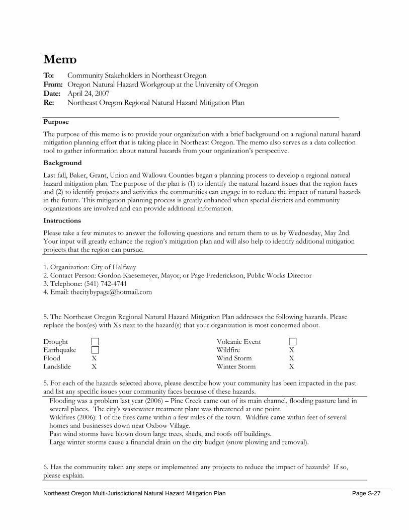
Memo To: Community Stakeholders in Northeast Oregon From: Oregon Natural Hazard Workgroup at the University of Oregon Date: April 24, 2007 Re: Northeast Oregon Regional Natural Hazard Mitigation Plan
Purpose
The purpose of this memo is to provide your organization with a brief background on a regional natural hazard mitigation planning effort that is taking place in Northeast Oregon. The memo also serves as a data collection tool to gather information about natural hazards from your organization’s perspective.
Background
Last fall, Baker, Grant, Union and Wallowa Counties began a planning process to develop a regional natural hazard mitigation plan. The purpose of the plan is (1) to identify the natural hazard issues that the region faces and (2) to identify projects and activities the communities can engage in to reduce the impact of natural hazards in the future. This mitigation planning process is greatly enhanced when special districts and community organizations are involved and can provide additional information.
Instructions
Please take a few minutes to answer the following questions and return them to us by Wednesday, May 2nd. Your input will greatly enhance the region’s mitigation plan and will also help to identify additional mitigation projects that the region can pursue. 1. Organization: City of Halfway 2. Contact Person: Gordon Kaesemeyer, Mayor; or Page Frederickson, Public Works Director 3. Telephone: (541) 742-4741 4. Email: [email protected] 5. The Northeast Oregon Regional Natural Hazard Mitigation Plan addresses the following hazards. Please replace the box(es) with Xs next to the hazard(s) that your organization is most concerned about. Drought Earthquake Flood X Landslide X
Volcanic Event Wildfire X Wind Storm X Winter Storm X
5. For each of the hazards selected above, please describe how your community has been impacted in the past and list any specific issues your community faces because of these hazards.
Flooding was a problem last year (2006) – Pine Creek came out of its main channel, flooding pasture land in several places. The city’s wastewater treatment plant was threatened at one point. Wildfires (2006): 1 of the fires came within a few miles of the town. Wildfire came within feet of several homes and businesses down near Oxbow Village. Past wind storms have blown down large trees, sheds, and roofs off buildings. Large winter storms cause a financial drain on the city budget (snow plowing and removal).
6. Has the community taken any steps or implemented any projects to reduce the impact of hazards? If so, please explain.
Northeast Oregon Multi-Jurisdictional Natural Hazard Mitigation Plan Page S-27

Northeast Oregon Multi-Jurisdictional Natural Hazard Mitigation Plan Page S-28
No major projects, but last year when flooding and high creek water threatened the city’s wastewater lagoons, a small dike was built to help hold the high water back. Landowners and ODOT paid to have a small area of Pine Creek deepened. 7. Are there any risk reduction projects or activities that your community would like to implement? We would like to see a study done on the whole Pine Creek – to determine possible flooding areas, and to see if material removed to deepen the creek would allow for better flow of high water.
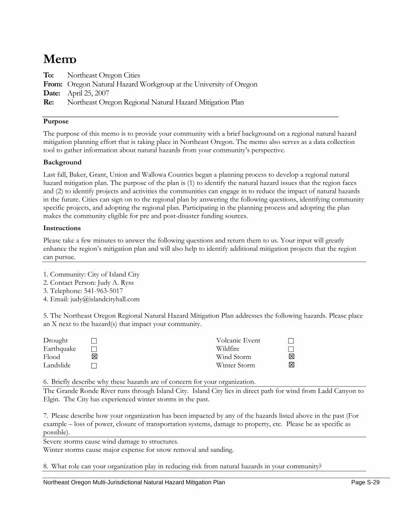
Northeast Oregon Multi-Jurisdictional Natural Hazard Mitigation Plan Page S-29
Memo To: Northeast Oregon Cities From: Oregon Natural Hazard Workgroup at the University of Oregon Date: April 25, 2007 Re: Northeast Oregon Regional Natural Hazard Mitigation Plan
Purpose
The purpose of this memo is to provide your community with a brief background on a regional natural hazard mitigation planning effort that is taking place in Northeast Oregon. The memo also serves as a data collection tool to gather information about natural hazards from your community’s perspective.
Background
Last fall, Baker, Grant, Union and Wallowa Counties began a planning process to develop a regional natural hazard mitigation plan. The purpose of the plan is (1) to identify the natural hazard issues that the region faces and (2) to identify projects and activities the communities can engage in to reduce the impact of natural hazards in the future. Cities can sign on to the regional plan by answering the following questions, identifying community specific projects, and adopting the regional plan. Participating in the planning process and adopting the plan makes the community eligible for pre and post-disaster funding sources.
Instructions
Please take a few minutes to answer the following questions and return them to us. Your input will greatly enhance the region’s mitigation plan and will also help to identify additional mitigation projects that the region can pursue. 1. Community: City of Island City 2. Contact Person: Judy A. Ryss 3. Telephone: 541-963-5017 4. Email: [email protected] 5. The Northeast Oregon Regional Natural Hazard Mitigation Plan addresses the following hazards. Please place an X next to the hazard(s) that impact your community. Drought Earthquake Flood Landslide
Volcanic Event Wildfire Wind Storm Winter Storm
6. Briefly describe why these hazards are of concern for your organization. The Grande Ronde River runs through Island City. Island City lies in direct path for wind from Ladd Canyon to Elgin. The City has experienced winter storms in the past. 7. Please describe how your organization has been impacted by any of the hazards listed above in the past (For example – loss of power, closure of transportation systems, damage to property, etc. Please be as specific as possible). Severe storms cause wind damage to structures. Winter storms cause major expense for snow removal and sanding. 8. What role can your organization play in reducing risk from natural hazards in your community?
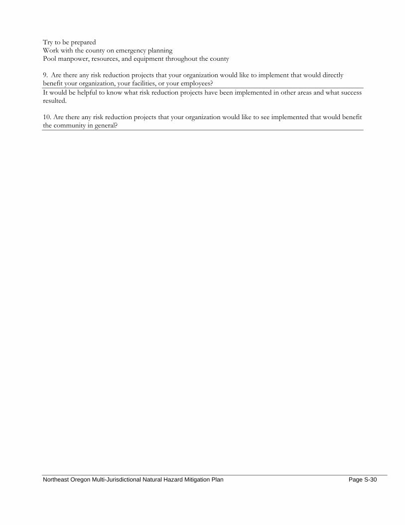
Northeast Oregon Multi-Jurisdictional Natural Hazard Mitigation Plan Page S-30
Try to be prepared Work with the county on emergency planning Pool manpower, resources, and equipment throughout the county 9. Are there any risk reduction projects that your organization would like to implement that would directly benefit your organization, your facilities, or your employees? It would be helpful to know what risk reduction projects have been implemented in other areas and what success resulted. 10. Are there any risk reduction projects that your organization would like to see implemented that would benefit the community in general?
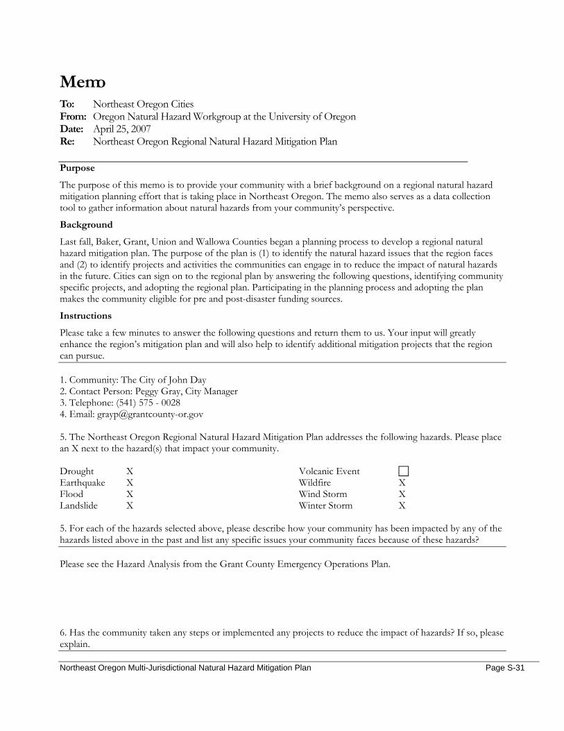
Northeast Oregon Multi-Jurisdictional Natural Hazard Mitigation Plan Page S-31
Memo To: Northeast Oregon Cities From: Oregon Natural Hazard Workgroup at the University of Oregon Date: April 25, 2007 Re: Northeast Oregon Regional Natural Hazard Mitigation Plan
Purpose
The purpose of this memo is to provide your community with a brief background on a regional natural hazard mitigation planning effort that is taking place in Northeast Oregon. The memo also serves as a data collection tool to gather information about natural hazards from your community’s perspective.
Background
Last fall, Baker, Grant, Union and Wallowa Counties began a planning process to develop a regional natural hazard mitigation plan. The purpose of the plan is (1) to identify the natural hazard issues that the region faces and (2) to identify projects and activities the communities can engage in to reduce the impact of natural hazards in the future. Cities can sign on to the regional plan by answering the following questions, identifying community specific projects, and adopting the regional plan. Participating in the planning process and adopting the plan makes the community eligible for pre and post-disaster funding sources.
Instructions
Please take a few minutes to answer the following questions and return them to us. Your input will greatly enhance the region’s mitigation plan and will also help to identify additional mitigation projects that the region can pursue. 1. Community: The City of John Day 2. Contact Person: Peggy Gray, City Manager 3. Telephone: (541) 575 - 0028 4. Email: [email protected] 5. The Northeast Oregon Regional Natural Hazard Mitigation Plan addresses the following hazards. Please place an X next to the hazard(s) that impact your community. Drought X Earthquake X Flood X Landslide X
Volcanic Event Wildfire X Wind Storm X Winter Storm X
5. For each of the hazards selected above, please describe how your community has been impacted by any of the hazards listed above in the past and list any specific issues your community faces because of these hazards?
Please see the Hazard Analysis from the Grant County Emergency Operations Plan.
6. Has the community taken any steps or implemented any projects to reduce the impact of hazards? If so, please explain.
Northeast Oregon Multi-Jurisdictional Natural Hazard Mitigation Plan Page S-32
Drought- In 2001 the City of John Day’s Water System Master Plan was finalized and will be used for the next twenty years as a resource for future planning of the City’s water system. The most critical project identified was to have more water storage and a new water source. In 2002 a new 850,000 gallon water reservoir was completed and a new well and pump station are now in service. This gives the City a total of approximately 1,689,800 gallons of water storage. The City of John Day also extended water lines to the Grant County Regional Airport in 2005 and added a 250,000 water reservoir giving the airport and new industrial park added fire protection. Flood – Since the 1964 flood; the Army Corps of Engineers have completed some channel work on the John Day River in an effort to keep the river from overflowing caused by rapid snowmelt from warm rains in the mountain regions. A Land Use Development Code has been implemented to make sure development in flood plain areas are reasonably safe from flooding and comply with applicable code regulations. Landslides – Areas have been identified and Development Code requires a site investigation report for the subject area.
Wildfire – In 2004 the Grant County Fire Plan was completed. The goals of the Fire Plan are as follows:
1. To make people of the community aware of and foster a respect for the risk of fire throughout the county.
2. To develop strategies for fuel reduction and fire suppression that Grant County residents can understand to better protect against catastrophic fire and that all agencies can incorporate into their management practices.
3. To make all agencies and residents of the county aware of programs available (that will help financially and through training) to reduce the potential of loss of life or property to wildfire.
Winter Storm – During times of extreme winter weather, various agencies will be called upon to expand their operations. These operations must be coordinated in order to maximize their effectiveness. Grant County has several agencies which can provide support to local agencies as needed. 7. Are there any risk reduction projects or activities that your community would like to implement?
A Risk Management Plan and concerns regarding the need for updating our Grant County Emergency Operations Plan.
Northeast Oregon Multi-Jurisdictional Natural Hazard Mitigation Plan Page S-33
Memo To: Northeast Oregon Cities From: Oregon Natural Hazard Workgroup at the University of Oregon Date: April 25, 2007 Re: Northeast Oregon Regional Natural Hazard Mitigation Plan
Purpose
The purpose of this memo is to provide your community with a brief background on a regional natural hazard mitigation planning effort that is taking place in Northeast Oregon. The memo also serves as a data collection tool to gather information about natural hazards from your community’s perspective.
Background
Last fall, Baker, Grant, Union and Wallowa Counties began a planning process to develop a regional natural hazard mitigation plan. The purpose of the plan is (1) to identify the natural hazard issues that the region faces and (2) to identify projects and activities the communities can engage in to reduce the impact of natural hazards in the future. Cities can sign on to the regional plan by answering the following questions, identifying community specific projects, and adopting the regional plan. Participating in the planning process and adopting the plan makes the community eligible for pre and post-disaster funding sources.
Instructions
Please take a few minutes to answer the following questions and return them to us. Your input will greatly enhance the region’s mitigation plan and will also help to identify additional mitigation projects that the region can pursue. 1. Community: City Of La Grande 2. Contact Person: 3. Telephone: 4. Email: 5. The Northeast Oregon Regional Natural Hazard Mitigation Plan addresses the following hazards. Please place an X next to the hazard(s) that impact your community. Drought Earthquake Flood Landslide
Volcanic Event Wildfire Wind Storm Winter Storm
5. For each of the hazards selected above, please describe how your community has been impacted by any of the hazards listed above in the past and list any specific issues your community faces because of these hazards?
Drought-the impact of drought will be felt county wide, it is not expected that the city will have any impacts above and beyond what the county experiences. Earthquake-There are several areas within the city limits that are seismically sensitive, notably the Sunnyhills Area, the downtown area because of the number of older buildings, and the Hospital, which has a fault line underlying the facility.
Northeast Oregon Multi-Jurisdictional Natural Hazard Mitigation Plan Page S-34
Flood-The Morgan Lake Dam is currently considered a high risk dam, if it breaks, Deal Canyon and school areas are expected to be in the flood area. The Grande Ronde River has flooded within the city limits several times in the past and given the right conditions will certainly flood again. Landslide-Landslide is a low risk. However there are buildings and homes on and around hillsides at higher risk. Volcanic Activity-the Mount St. Helen’s eruption did impact La Grande with a coating of ash, and there are several active volcanoes near enough that given the right conditions could have an impact on the city as well. Wildfire-The Rooster Peak fire in the 1970’s destroyed several homes, and endangered many other structures. The City is bordered by forestlands and wildfire is always a risk. Wind Storm-Windstorms are frequent particularly in the summers when they are associated with thunderstorms. The storms have caused structural damage, electrical outages, traffic disruption, etc. Winter Storm-Winter storms often close the passes around La Grande, disrupting transportation of supplies and individual travel. The snow and ice can also pose a hazard in the city, slowing traffic, contributing to an increase in traffic accidents, causing electrical outages and structural damage.
6. Has the community taken any steps or implemented any projects to reduce the impact of hazards? If so, please explain.
Overall, the City has adopted the Union County Emergency Response Plan for responding to any emergency including all the natural disasters listed above. Drought-The City has a Water Master Plan which addresses water use conservation and other measures that can be implemented in the case of drought. Earthquake-City building codes specify seismic building requirements for new construction, these codes have been in place since 1975. Flood-The Morgan Lake Dam is inspected annually by the State Dam Safety Office, any recommended measures are undertaken by the City. The City has adopted a Surface Water Plan and has a Storm Water Program intended to reduce the impact of flooding due to storm conditions. Volcanic Activity-no projects known. Wildfire-no projects known. Wind Storm-The City has a robust Urban Forestry program, which includes monitoring the health of trees in the right-of-way, replacing old and unhealthy trees, and a trimming and branch removal process to lessen extent of damage trees may cause during wind events. Winter Storm-The City has street program for applying rock on the streets when icy and slick, and plowing when the snow reaches 6 inches.
7. Are there any risk reduction projects or activities that your community would like to implement? The City would like some information on what types of risk reduction projects and/or activities are available and have demonstrated effectiveness.
Northeast Oregon Multi-Jurisdictional Natural Hazard Mitigation Plan Page S-35
Date: February 28, 2007 Time: 11:30am – 12:00pm Location: City Hall, Richland OR Subject: City of Richland Stakeholder Interview On February 28, 2007 Megan Findley interviewed Gerri Stevens, Richland City Administrator. The following document summarizes their discussion. General Questions
1. From your organization’s perspective, what hazard(s) pose the greatest threat to the community and why? Earthquake; the city is located on a fault line. Hole-in-the wall landslide caused highway closures; this highlighted the need alternate routes in and out of the city.
2. Does your organization maintain information or data on the impact of previous disasters? How so?
No (little need to do so). Community Vulnerability
Population 3. Are there certain populations within the community that might be at greater risk? Please explain…
Elderly populations 4. What organizations in the community provide services to special populations in the community?
Community Connection from Baker provides a bus to Baker City once a week, and senior meals one day a week in Halfway and one day a week in Richland (with transportation included)
Economic Assets 5. How might natural hazards impact the local economy?
Landslides can potentially close highways and isolate the city from the transport of goods; Persons within Richland depend on Baker for shopping needs and medical services (hospital). An earthquake would devastate the area.
6. Which businesses would be significantly impacted by the temporary loss of utilities?
Everyone would be affected: restaurants, bar, grocery store, liquor store, feed store, telephone company, TV cable company, real estate business, motel, gas station, city hall
Cultural and Historic 7. Are there cultural or historic resources that are important to the community? What are they?
Eagle Valley Cemetery, a pioneer cemetery about a mile from city limits
Critical Facilities and Infrastructure 8. What critical facilities and infrastructure does your community rely on to function?
Water, sewer, streets & highway, telephone, Power Company, TV cable, cell phone, internet (for bill pay)
Natural Resources 9. Could natural hazards impact environmental resources in your community? If so, how?
Tourism (hunting/fishing: Brownley reservoir) All-American Road; Hells Canyon Scenic Byway; Bike Trail
Northeast Oregon Multi-Jurisdictional Natural Hazard Mitigation Plan Page S-36
Land Use and Development 10. Do you foresee population growth or change in your community? If so, where?
No 11. Are there existing developments in areas you think are subject to natural hazards?
The entire jurisdiction is at risk for the hazards most likely to affect Richland
a. What are the current and future development trends? None
Resources/Activities
12. Does your organization currently work in natural hazard mitigation? If yes, how? No
13. What role can your organization play in reducing risk in your community? Unaware of any current reasons and/or ways to reduce risk
14. Does your organization have any plans or policies that affect local residents, the economy, natural
resources, or land use and development? Zoning ordinance
Action Items
15. What activities do you think your community should take to reduce risk and prevent loss from future natural hazard events? (If you had the $, how would you spend it?) Structurally retrofit essential buildings and hire a building inspector for guidance; Purchase equipment to clear debris should an earthquake or slide occur Purchase a snow plow
a. Are there any activities your organization could do to reduce risk?
NA
16. In what ways would you like to see agencies, organizations or individuals in NE Oregon participate and coordinate to reduce risk from natural hazards? There should be better coordination between the cities and county for emergency preparedness/response.
a. What agencies or organizations in the community or the region do you think should be
involved in risk reduction activities in this community? NA
17. Can you think of other people or organizations we should contact?
Mayor; Volunteer Fire Department
Northeast Oregon Multi-Jurisdictional Natural Hazard Mitigation Plan Page S-37
Date: March 8, 2007 Time: NA Location: NA Subject: City of Sumpter Stakeholder Interview On March 8, 2007 Toni Thompson, Sumpter City Administrator, completed the following stakeholder interview on her own: General Questions
1. From your organization’s perspective, what hazard(s) pose the greatest threat to the community and why? Wildfires: We are basically surrounded by forest and could be wiped out if a fire got started nearby and quickly got out of control. Also, our watershed is vulnerable to fires; if this occurred we would be without water.
2. Does your organization maintain information or data on the impact of previous disasters? How so? No.
Community Vulnerability
Population 3. Are there certain populations within the community that might be at greater risk? Please explain…
Our population includes a large share or elderly who would be unable to fight a fire or move quickly to get away from one. We also have a large group of homes owned as second homes and there might not be someone present to protect the structure.
4. What organizations in the community provide services to special populations in the community?
No particular organization; we all try to watch out for each other.
Economic Assets 5. How might natural hazards impact the local economy?
Our economy is very tourism-oriented. Any large fire or other significant material disaster would keep people away and that would impact all businesses & therefore all citizens.
6. Which businesses would be significantly impacted by the temporary loss of utilities? Any of our businesses would be impacted by loss of utilities, regardless of how temporary and any problem in our watershed could result in loss of water for an extended period of time.
Cultural and Historic 7. Are there cultural or historic resources that are important to the community? What are they?
A number of historic buildings and homes – Sumpter Valley Dredge State Heritage (Yuba style dredge) Area. Sumpter Valley Railroad Restoration.
Critical Facilities and Infrastructure 8. What critical facilities and infrastructure does your community rely on to function?
Water, electricity, and highways
Natural Resources 9. Could natural hazards impact environmental resources in your community? If so, how?
Absolutely – again, anything that impacts our watershed (could be fire, landslide, erosion on a large scale) adversely impacts us.
Northeast Oregon Multi-Jurisdictional Natural Hazard Mitigation Plan Page S-38
Land Use and Development 10. Do you foresee population growth or change in your community? If so, where?
Yes – the newer developments will be in more heavily forested areas.
11. Are there existing developments in areas you think are subject to natural hazards? The town is surrounded by forest and we have a large amount of trees within the city limits.
a. What are the current and future development trends? More buildings in less accessible, heavily forested areas
Resources/Activities
12. Does your organization currently work in natural hazard mitigation? If yes, how? Try to use our land use regulations to mitigate the impact of growth in forested areas.
13. What role can your organization play in reducing risk in your community?
Keep land use regulation up to date and made to protect people in forested areas. Try to work with USFS to help reduce fuel loads in the watershed and to keep timber harvesting from making large areas subject to erosion or landslides.
14. Does your organization have any plans or policies that affect local residents, the economy, natural
resources, or land use and development? As the City, we have plans and policies that affect all of the above.
Action Items
15. What activities do you think your community should take to reduce risk and prevent loss from future natural hazard events? (If you had the $, how would you spend it?) We have worked with the State Dept. of Forestry on wildfire mitigation plans. This has helped but as population increases with the more rural areas this helps less.
a. Are there any activities your organization could do to reduce risk?
NA
16. In what ways would you like to see agencies, organizations or individuals in NE Oregon participate and coordinate to reduce risk from natural hazards? Public meetings have been held and these help. The wildland fuels reduction program helps. People need to help themselves with choices of roofing, etc.
a. What agencies or organizations in the community or the region do you think should be
involved in risk reduction activities in this community? City of Sumpter, Baker County, Forestry, BLM, USFS, Watershed Councils, Ranchers, Fire Departments, etc.
17. Can you think of other people or organizations we should contact?
All of the above
Northeast Oregon Multi-Jurisdictional Natural Hazard Mitigation Plan Page S-39
Date: January 10, 2007 Time: 10:30am Location: City Hall, Union OR Subject: City of Union Stakeholder Interview On January 10, 2007 Megan Findley interviewed Jeff Wise, Union City Administrator, and Paul Phillips, Union City Public Works. The following summarizes their discussion: General Questions
1. From your organization’s perspective, what hazard(s) pose the greatest threat to the community and why? Severe winter storms; we don’t have the equipment to handle heavy amounts of snow Drought – warming
2. Does your organization maintain information or data on the impact of previous disasters? How so?
Yes, current issues/disasters have files. Community Vulnerability
Population 3. Are there certain populations within the community that might be at greater risk? Please explain…
Elderly – immune systems; Union is turning into a bedroom community to La Grande 4. What organizations in the community provide services to special populations in the community?
Church groups – The Latter Day Saints, the Methodist Church; Lions Club
Economic Assets 5. How might natural hazards impact the local economy?
Connections to La Grande are necessary. A large part of community’s economy is reliant on tourism and commuters; thus, roads are vital for its continued success. The city is dependent on La Grande’s merchandise due to the introduction of Wal-Mart. Highway connections between the two cities are important. The local government does not have the funds to repair or handle any disaster and/or its ramifications.
6. Which businesses would be significantly impacted by the temporary loss of utilities?
The health clinic, grocery stores, businesses. Without heat, the elderly would suffer.
Cultural and Historic 7. Are there cultural or historic resources that are important to the community? What are they?
Union is an historic town; there are many historic buildings here, and the city is reliant upon these buildings for tourism. Most of downtown buildings are on the national historic register, and many homes have signs indicating when they were built. Brick foundry Carnegie library (one of the few remaining)
Critical Facilities and Infrastructure 8. What critical facilities and infrastructure does your community rely on to function?

Northeast Oregon Multi-Jurisdictional Natural Hazard Mitigation Plan Page S-40
Wastewater treatment plant; 2 wells; Victorian homes and businesses; two highways; health clinic, drug store.
Natural Resources 9. Could natural hazards impact environmental resources in your community? If so, how?
Yes; if water became contaminated, we’re not equipped to distribute water bottles; Freezing causes flooding and takes out the roads. Heavy snow could impact the farming / cattle operations, as could drought. Threat of ice thaw breakage and clogging: ice breakages can hit bridges unless broken up before damage can occur.
Land Use and Development 10. Do you foresee population growth or change in your community? If so, where?
The city foresees growth; large portions of land recently purchased for global online distributing (warehouses); residential growth will occur from a new windmill facility that’s going up by Telecaset. *The city is looking to expand its economic base with the hope that growth results.
11. Are there existing developments in areas you think are subject to natural hazards?
Most of the town is in a 100 to 500 year floodplain
a. What are the current and future development trends? Currently: a lot of land is being bought.
Resources/Activities
12. Does your organization currently work in natural hazard mitigation? If yes, how? No; the City relies on the County due to lack of funding
13. What role can your organization play in reducing risk in your community?
Union is in active alliance with the county; it share an intergovernmental agreement with Northeast Oregon counties to share equipment in the event of disasters.
14. Does your organization have any plans or policies that affect local residents, the economy, natural
resources, or land use and development? Land use and planning strategies / policies and ordinances.
Action Items
15. What activities do you think your community should take to reduce risk and prevent loss from future natural hazard events? (If you had the $, how would you spend it?) Put money towards the volunteer fire and ambulance department; upgrade equipment (new ambulance), develop strategic disaster response planning. EMS is looking for new defibrillators, and they need a new alarm bell (gets stuck in the “on” position).
a. Are there any activities your organization could do to reduce risk? NA
16. In what ways would like to see agencies, organizations or individuals in NE Oregon participate and
coordinate to reduce risk from natural hazards? Dara D. Salmon (Union County Emergency Services) currently does a great job at coordinating efforts, and keeping the cities informed of funding opportunities and training courses; the city would like to see her continue in her position.
Northeast Oregon Multi-Jurisdictional Natural Hazard Mitigation Plan Page S-41
a. What agencies or organizations in the community or the region do you think should be
involved in risk reduction activities in this community? Schools; retirement homes/adult foster care owners
17. Can you think of other people or organizations we should contact?
Sue Briggs, Union Chamber of Commerce Bill Hooker, fire chief Claracy Hancock – city secretary (utility billing clerk) Mike Colkitt – Union Market (grocery store), member of fire department, ambulance, and business owner
Northeast Oregon Multi-Jurisdictional Natural Hazard Mitigation Plan Page S-42
Memo To: Community Stakeholders in Northeast Oregon From: Oregon Natural Hazard Workgroup at the University of Oregon Date: April 24, 2007 Re: Northeast Oregon Regional Natural Hazard Mitigation Plan
Purpose
The purpose of this memo is to provide your organization with a brief background on a regional natural hazard mitigation planning effort that is taking place in Northeast Oregon. The memo also serves as a data collection tool to gather information about natural hazards from your organization’s perspective.
Background
Last fall, Baker, Grant, Union and Wallowa Counties began a planning process to develop a regional natural hazard mitigation plan. The purpose of the plan is (1) to identify the natural hazard issues that the region faces and (2) to identify projects and activities the communities can engage in to reduce the impact of natural hazards in the future. This mitigation planning process is greatly enhanced when special districts and community organizations are involved and can provide additional information.
Instructions
Please take a few minutes to answer the following questions and return them to us by Wednesday, May 2nd. Your input will greatly enhance the region’s mitigation plan and will also help to identify additional mitigation projects that the region can pursue. 1. Organization: Community Connection of Baker County; 2810 Cedar St, Baker City, OR 97814 2. Contact Person: Mary Jo Carpenter 3. Telephone: (541) 523 - 6591 4. Email: [email protected] 5. The Northeast Oregon Regional Natural Hazard Mitigation Plan addresses the following hazards. Please replace the box(es) with Xs next to the hazard(s) that your organization is most concerned about. Drought Earthquake Flood X Landslide
Volcanic Event Wildfire Wind Storm X Winter Storm X
6.. Briefly describe why these hazards are of concern for your organization. Please be as specific as possible. Our concern in a natural hazard event would be the care and help for the frail seniors in our community. These are people who usually live alone in their homes, and may or may not have local family to help them in a disaster. Our goal would be to see that they have transportation, food, shelter, and medical care, and/or help with medications. 7. Please describe how your organization has been impacted by any of the hazards listed above in the past? (For example - loss of power, closure of transportation systems, damage to property, etc. Please be as specific as possible). Windstorm: perhaps one time per year, there has been short-term power loss (less than 2 hours); no significant impact on seniors.
8. What role can your organization play in reducing risk from natural hazards in your community? Provision of transportation, food, shelter (at facility). 9. Are there any risk reduction projects that your organization would like to implement that would directly benefit your organization, your facilities or your employees? 10. Are there any risk reduction projects that your organization would like to see implemented that would benefit the community in general? We are currently involved in the DHS (Department of Human Services) Emergency Preparedness planning group, but we would like to address the needs of frail/vulnerable populations in case of disaster. Contact at DHS in Salem: Connie Soldana
Northeast Oregon Multi-Jurisdictional Natural Hazard Mitigation Plan Page S-43
Date: March 22, 2007 Time: 10:30am Location: 1504 Albany St Subject: La Grande Community Connections Senior Center Stakeholder Interview On March 22, 2007 a representative from the La Grande Community Connections Senior Center completed this survey on her own. The following lists her responses: General Questions
1. From your organization’s perspective, what hazard(s) pose the greatest threat to the community and why? Snow and ice storms
2. Does your organization maintain information or data on the impact of previous disasters? How so?
No Community Vulnerability
Population 3. Are there certain populations within the community that might be at greater risk? Please explain…
Yes, seniors and low income citizens. 4. What organizations in the community provide services to special populations in the community?
Community Connections, Shelter from the Storm, Neighbor to Neighbor ministries.
Economic Assets 5. How might natural hazards impact the local economy?
Disruptions to transportation systems via natural hazards may impact the local economy.
6. Which businesses would be significantly impacted by the temporary loss of utilities? Hospitals, senior care facilities, grocery stores, etc.
Cultural and Historic 7. Are there cultural or historic resources that are important to the community? What are they?
Yes
Critical Facilities and Infrastructure 8. What critical facilities and infrastructure does your community rely on to function?
Hospital and grocery stores
Natural Resources 9. Could natural hazards impact environmental resources in your community? If so, how?
Yes. We have a large population of farmers, and our communities rely on their successes. Land Use and Development 10. Do you foresee population growth or change in your community? If so, where?
Yes, I believe our community is growing very quickly.
11. Are there existing developments in areas you think are subject to natural hazards? NA
a. What are the current and future development trends?
Northeast Oregon Multi-Jurisdictional Natural Hazard Mitigation Plan Page S-44

Resources/Activities 12. Does your organization currently work in natural hazard mitigation? If yes, how?
No
13. What role can your organization play in reducing risk in your community? We can participate in awareness campaigns.
14. Does your organization have any plans or policies that affect local residents, the economy, natural
resources, or land use and development? No
Action Items
15. What activities do you think your community should take to reduce risk and prevent loss from future natural hazard events? (If you had the $, how would you spend it?) Awareness meetings / information dissemination
a. Are there any activities your organization could do to reduce risk?
We can inform seniors with any necessary information.
16. In what ways would you like to see agencies, organizations or individuals in NE Oregon participate and coordinate to reduce risk from natural hazards? NA
a. What agencies or organizations in the community or the region do you think should be
involved in risk reduction activities in this community? Hospital, fire station, police, Eastern Oregon University, La Grande High School
17. Can you think of other people or organizations we should contact?
Northeast Oregon Multi-Jurisdictional Natural Hazard Mitigation Plan Page S-45

Memo To: Community Stakeholders in Northeast Oregon From: Oregon Natural Hazard Workgroup at the University of Oregon Date: April 24, 2007 Re: Northeast Oregon Regional Natural Hazard Mitigation Plan
Purpose
The purpose of this memo is to provide your organization with a brief background on a regional natural hazard mitigation planning effort that is taking place in Northeast Oregon. The memo also serves as a data collection tool to gather information about natural hazards from your organization’s perspective.
Background
Last fall, Baker, Grant, Union and Wallowa Counties began a planning process to develop a regional natural hazard mitigation plan. The purpose of the plan is (1) to identify the natural hazard issues that the region faces and (2) to identify projects and activities the communities can engage in to reduce the impact of natural hazards in the future. This mitigation planning process is greatly enhanced when special districts and community organizations are involved and can provide additional information.
Instructions
Please take a few minutes to answer the following questions and return them to us by Wednesday, May 2nd. Your input will greatly enhance the region’s mitigation plan and will also help to identify additional mitigation projects that the region can pursue. 1. Organization: Eastern Oregon Head Start 2. Contact Person: Marilyn Herbst 3. Telephone: (541) 962 - 3798 4. Email: [email protected] 5. The Northeast Oregon Regional Natural Hazard Mitigation Plan addresses the following hazards. Please replace the box(es) with Xs next to the hazard(s) that your organization is most concerned about. Drought Earthquake Flood X Landslide
Volcanic Event Wildfire Wind Storm X Winter Storm X
6. Briefly describe why these hazards are of concern for your organization. Please be as specific as possible. We have centers in La Grande, Baker City, Union and Elgin. All are within city limits and operate September – May. In the 30+ years I have lived in Union County, flood, wind and snow have been the major hazards in these areas.
Northeast Oregon Multi-Jurisdictional Natural Hazard Mitigation Plan Page S-46

7. Please describe how your organization has been impacted by any of the hazards listed above in the past? (For example - loss of power, closure of transportation systems, damage to property, etc. Please be as specific as possible). All of the items listed above have affected our centers. We have concerns about 1) children being stranded at the centers for extended hours from weather related hazards, and 2) having water and food supplies on hand for emergencies. 8. What role can your organization play in reducing risk from natural hazards in your community? Have a response plan in place Communication / plan with parents Trained staff / emergency preparedness 9. Are there any risk reduction projects that your organization would like to implement that would directly benefit your organization, your facilities or your employees?
- Staff training from emergency services - Possibly role play practice as we do for CPR & First Aid training
10. Are there any risk reduction projects that your organization would like to see implemented that would benefit the community in general? Closer communication and understanding of what we should do and what emergency services would do in case of disaster.
Northeast Oregon Multi-Jurisdictional Natural Hazard Mitigation Plan Page S-47
Date: April 11, 2007 Time: 9:00am Location: Eastern Oregon University Subject: Eastern Oregon University Stakeholder Interview On April 11, 2007 Megan Findley interviewed Rob Yuodelis, Director of Eastern Oregon University Environmental Health and Safety. The following document summarizes their discussion. Main Concerns (summary):
• Age of buildings and earthquake-readiness • Lack of coordination between University employees and La Grande officials re: hazard mitigation
and response. • Hazardous materials in Badgley Hall: should they be released, the University and City are
unprepared to respond in an adequate fashion. • Flooding potential to both Quinn Coliseum and Hoke Hall, both of which are Red Cross shelters for
the City. • Pierce library contains historic materials of significant, immeasurable value. • Eastern Oregon University is built atop what used to be a large cemetery. Because many of the
graves were unmarked, bodies remain on-site. New construction or digging of any kind presents problems.
• All of the University’s utilities run through the steam tunnels. If one segment breaks, all utilities will be disrupted. The vulnerability and resilience of these steam tunnels is unknown. The utilities have been organized like this for fear of digging in new areas and finding new graves.
• The University and its professors rely on distance education for a significant part of their incomes. Internet connections are thus essential. Likewise, the University maintains a number of partnerships. Staff persons from various locations will rely on the University for assistance in times of disaster.
• Campus population is highest at 10:00am during weekdays; population concentrations vary significantly throughout the day and year.
Discussion topics: Critical facilities on campus include the Physical Plant and the Facilities and Planning building. The Physical Plant contains boilers and generates heat. Facilities and Planning performs maintenance and repairs throughout campus. These two buildings are right next to each other on the east side of campus. Pierce Library is another critical component of the University; the library maintains communication systems throughout campus and La Grande (for K-12 schools) and throughout the nation for distance education. Pierce library has been flooded in the past; as a result, the building has been retrofitted for flood and fire resilience, and a backup generator is on-hand. Quinn Hall and the Hoke Student Union Building are Red Cross designated shelters for the City of La Grande. Quinn is the University’s gymnasium and can hold large amounts of people; Hoke has a cafeteria and cooking resources available. Both buildings are on low ground and sit within the path of a natural drainage system. Between the two buildings, engineers have crafted a stormwater drainage system that is currently used as a volleyball court. If the configuration of this system changes, either by a drainage backup or earthquake, the shelters would most likely flood. The University will occasionally experience short-term power-outages. Power comes to the University from an outside source. The boilers in the Physical Plant are fed by gas; the University is exploring new developments in biomass to secure additional and more reliable heating sources. Badgley Hall sits on a steep slope, and has been secured by deep footings. Nevertheless, the potential threat of earthquakes or fire raises issues within this building. Should they be released, the third floor of Badgley Northeast Oregon Multi-Jurisdictional Natural Hazard Mitigation Plan Page S-48
contains a threatening amount of hazardous materials. The City of La Grande is probably not prepared to handle a potential disaster of such magnitude. Side not: the University performs a hazardous materials inventory every year. The University’s population varies greatly depending on the time of day and year. 10:00am during the school year is the peak time for students to be on campus. After 2:00pm, building occupancy is primarily reduced to University employees. Buildings with highest occupancies during the day are Badgley, Loso Hall, and the dormitories. Additionally, the University maintains a number of partnerships with various organizations. Employees from various locations are housed at EOU like tenants; if EOU is part of a natural disaster, employees within all of the partnerships will look to EOU for response and suffer economic consequences if EOU cannot respond in a timely fashion. This includes professors who rely on distance education (and internet connections) for the majority of their salary. Growth within the University is projected to be near 10% over the next five years. Badgley Hall is slated to grow into its adjacent parking lot, and a new library (location undetermined) will be built. Dorian Hall, the old dormitory building, will be torn down and Hunt Hall will be remodeled. Eastern Oregon University is built on top of what used to be a large cemetery. Pauper graves (unmarked grave sites) have been found during constructions. Any new projects thus require extra time, money, and labor to ensure that graves are not touched. The Community School of the Arts (CSA) serves the surrounding community with classes, music lessons, and group activities.
Northeast Oregon Multi-Jurisdictional Natural Hazard Mitigation Plan Page S-49
Memo To: Community Stakeholders in Northeast Oregon From: Oregon Natural Hazard Workgroup at the University of Oregon Date: May 2, 2007 Re: Northeast Oregon Regional Natural Hazard Mitigation Plan
Purpose
The purpose of this memo is to provide your organization with a brief background on a regional natural hazard mitigation planning effort that is taking place in Northeast Oregon. The memo also serves as a data collection tool to gather information about natural hazards from your organization’s perspective.
Background
Last fall, Baker, Grant, Union and Wallowa Counties began a planning process to develop a regional natural hazard mitigation plan. The purpose of the plan is (1) to identify the natural hazard issues that the region faces and (2) to identify projects and activities the communities can engage in to reduce the impact of natural hazards in the future. This mitigation planning process is greatly enhanced when special districts and community organizations are involved and can provide additional information.
Instructions
Please take a few minutes to answer the following questions and return them to us by Wednesday, May 2nd. Your input will greatly enhance the region’s mitigation plan and will also help to identify additional mitigation projects that the region can pursue. 1. Organization: Elgin Rural Fire Department 2. Contact Person: Patrick McDonald 3. Telephone: (541) 437 - 7241 4. Email: [email protected] 5. The Northeast Oregon Regional Natural Hazard Mitigation Plan addresses the following hazards. Please replace the box(es) with Xs next to the hazard(s) that your organization is most concerned about. Drought Earthquake Flood X Landslide X
Volcanic Event Wildfire X Wind Storm Winter Storm X
6. Briefly describe why these hazards are of concern for your organization. Please be as specific as possible. Our department has dealt with these situations in the past. We are mainly concerned with wildfires.
7. Please describe how your organization has been impacted by any of the hazards listed above in the past? (For example - loss of power, closure of transportation systems, damage to property, etc. Please be as specific as possible). We have spent many hours training and fighting wildfires. When a landslide broke the natural gas line feeding the town of Elgin, we assisted the gas company. 8. What role can your organization play in reducing risk from natural hazards in your community? We work closely with Oregon Department of Forestry and Fire Prevention Co-op in trying to promote safety.
Northeast Oregon Multi-Jurisdictional Natural Hazard Mitigation Plan Page S-50
9. Are there any risk reduction projects that your organization would like to implement that would directly benefit your organization, your facilities or your employees? We are presently planning on building a new fire station that will benefit the community we serve and be an asset to our organization. 10. Are there any risk reduction projects that your organization would like to see implemented that would benefit the community in general?
Northeast Oregon Multi-Jurisdictional Natural Hazard Mitigation Plan Page S-51
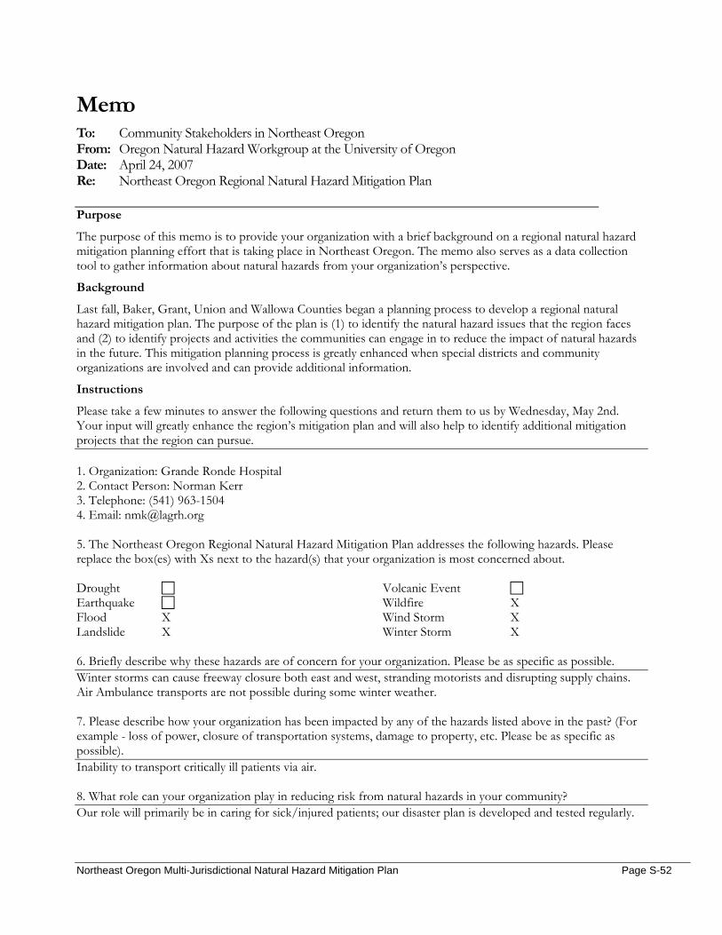
Memo To: Community Stakeholders in Northeast Oregon From: Oregon Natural Hazard Workgroup at the University of Oregon Date: April 24, 2007 Re: Northeast Oregon Regional Natural Hazard Mitigation Plan
Purpose
The purpose of this memo is to provide your organization with a brief background on a regional natural hazard mitigation planning effort that is taking place in Northeast Oregon. The memo also serves as a data collection tool to gather information about natural hazards from your organization’s perspective.
Background
Last fall, Baker, Grant, Union and Wallowa Counties began a planning process to develop a regional natural hazard mitigation plan. The purpose of the plan is (1) to identify the natural hazard issues that the region faces and (2) to identify projects and activities the communities can engage in to reduce the impact of natural hazards in the future. This mitigation planning process is greatly enhanced when special districts and community organizations are involved and can provide additional information.
Instructions
Please take a few minutes to answer the following questions and return them to us by Wednesday, May 2nd. Your input will greatly enhance the region’s mitigation plan and will also help to identify additional mitigation projects that the region can pursue. 1. Organization: Grande Ronde Hospital 2. Contact Person: Norman Kerr 3. Telephone: (541) 963-1504 4. Email: [email protected] 5. The Northeast Oregon Regional Natural Hazard Mitigation Plan addresses the following hazards. Please replace the box(es) with Xs next to the hazard(s) that your organization is most concerned about. Drought Earthquake Flood X Landslide X
Volcanic Event Wildfire X Wind Storm X Winter Storm X
6. Briefly describe why these hazards are of concern for your organization. Please be as specific as possible. Winter storms can cause freeway closure both east and west, stranding motorists and disrupting supply chains. Air Ambulance transports are not possible during some winter weather.
7. Please describe how your organization has been impacted by any of the hazards listed above in the past? (For example - loss of power, closure of transportation systems, damage to property, etc. Please be as specific as possible). Inability to transport critically ill patients via air. 8. What role can your organization play in reducing risk from natural hazards in your community? Our role will primarily be in caring for sick/injured patients; our disaster plan is developed and tested regularly.
Northeast Oregon Multi-Jurisdictional Natural Hazard Mitigation Plan Page S-52
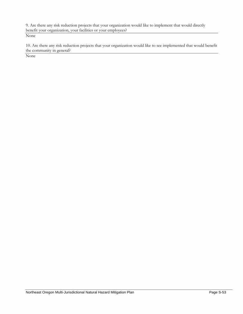
9. Are there any risk reduction projects that your organization would like to implement that would directly benefit your organization, your facilities or your employees? None 10. Are there any risk reduction projects that your organization would like to see implemented that would benefit the community in general? None
Northeast Oregon Multi-Jurisdictional Natural Hazard Mitigation Plan Page S-53
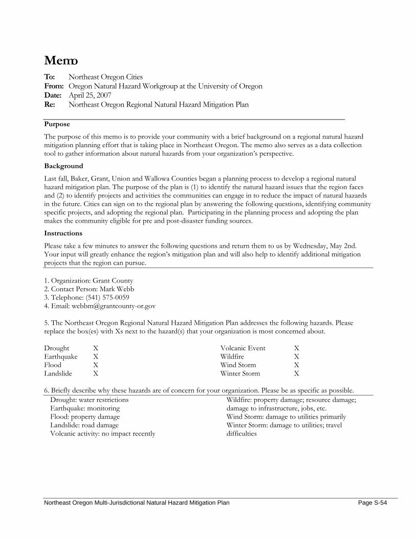
Memo To: Northeast Oregon Cities From: Oregon Natural Hazard Workgroup at the University of Oregon Date: April 25, 2007 Re: Northeast Oregon Regional Natural Hazard Mitigation Plan
Purpose
The purpose of this memo is to provide your community with a brief background on a regional natural hazard mitigation planning effort that is taking place in Northeast Oregon. The memo also serves as a data collection tool to gather information about natural hazards from your organization’s perspective.
Background
Last fall, Baker, Grant, Union and Wallowa Counties began a planning process to develop a regional natural hazard mitigation plan. The purpose of the plan is (1) to identify the natural hazard issues that the region faces and (2) to identify projects and activities the communities can engage in to reduce the impact of natural hazards in the future. Cities can sign on to the regional plan by answering the following questions, identifying community specific projects, and adopting the regional plan. Participating in the planning process and adopting the plan makes the community eligible for pre and post-disaster funding sources.
Instructions
Please take a few minutes to answer the following questions and return them to us by Wednesday, May 2nd. Your input will greatly enhance the region’s mitigation plan and will also help to identify additional mitigation projects that the region can pursue. 1. Organization: Grant County 2. Contact Person: Mark Webb 3. Telephone: (541) 575-0059 4. Email: [email protected] 5. The Northeast Oregon Regional Natural Hazard Mitigation Plan addresses the following hazards. Please replace the box(es) with Xs next to the hazard(s) that your organization is most concerned about. Drought X Earthquake X Flood X Landslide X
Volcanic Event X Wildfire X Wind Storm X Winter Storm X
6. Briefly describe why these hazards are of concern for your organization. Please be as specific as possible.
Drought: water restrictions Earthquake: monitoring Flood: property damage Landslide: road damage Volcanic activity: no impact recently
Wildfire: property damage; resource damage; damage to infrastructure, jobs, etc. Wind Storm: damage to utilities primarily Winter Storm: damage to utilities; travel difficulties
Northeast Oregon Multi-Jurisdictional Natural Hazard Mitigation Plan Page S-54

7. Has the community taken any steps or implemented any projects to reduce the impact of hazards? If so, please explain. See above 8. Are there any risk reduction projects or activities that your community would like to implement? Our primary concern lies with wildfire – a present danger to our communities, lives, and surrounding natural resources: take cost effective, responsible measures to address wildfires in our national forests.
Northeast Oregon Multi-Jurisdictional Natural Hazard Mitigation Plan Page S-55

Memo To: Community Stakeholders in Northeast Oregon From: Oregon Natural Hazard Workgroup at the University of Oregon Date: April 24, 2007 Re: Northeast Oregon Regional Natural Hazard Mitigation Plan
Purpose
The purpose of this memo is to provide your organization with a brief background on a regional natural hazard mitigation planning effort that is taking place in Northeast Oregon. The memo also serves as a data collection tool to gather information about natural hazards from your organization’s perspective.
Background
Last fall, Baker, Grant, Union and Wallowa Counties began a planning process to develop a regional natural hazard mitigation plan. The purpose of the plan is (1) to identify the natural hazard issues that the region faces and (2) to identify projects and activities the communities can engage in to reduce the impact of natural hazards in the future. This mitigation planning process is greatly enhanced when special districts and community organizations are involved and can provide additional information.
Instructions
Please take a few minutes to answer the following questions and return them to us by Wednesday, May 2nd. Your input will greatly enhance the region’s mitigation plan and will also help to identify additional mitigation projects that the region can pursue. 1. Organization: Greater Eastern Oregon Development Corporation (GEODC) 2. Contact Person: Sondra Lino 3. Telephone: (541)575-2786 4. Email: [email protected] 5. The Northeast Oregon Regional Natural Hazard Mitigation Plan addresses the following hazards. Please replace the box(es) with Xs next to the hazard(s) that your organization is most concerned about. Drought Earthquake Flood Landslide
Volcanic Event Wildfire X Wind Storm X Winter Storm X
6. Briefly describe why these hazards are of concern for your organization. Please be as specific as possible. Hazards are not a focus of GEODC, but the issues checked are those most likely to impact the area that we serve.
7. Please describe how your organization has been impacted by any of the hazards listed above in the past? (For example - loss of power, closure of transportation systems, damage to property, etc. Please be as specific as possible). There has been no impact beyond cancellation of scheduled meetings due to hazardous driving conditions.
Northeast Oregon Multi-Jurisdictional Natural Hazard Mitigation Plan Page S-56
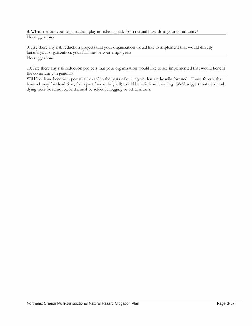
8. What role can your organization play in reducing risk from natural hazards in your community? No suggestions.
9. Are there any risk reduction projects that your organization would like to implement that would directly benefit your organization, your facilities or your employees? No suggestions. 10. Are there any risk reduction projects that your organization would like to see implemented that would benefit the community in general? Wildfires have become a potential hazard in the parts of our region that are heavily forested. Those forests that have a heavy fuel load (i. e., from past fires or bug kill) would benefit from cleaning. We’d suggest that dead and dying trees be removed or thinned by selective logging or other means.
Northeast Oregon Multi-Jurisdictional Natural Hazard Mitigation Plan Page S-57
Date: March 27, 2007 Time: 9:00am Location: Wallowa County Library, NEOEDD Office, Enterprise OR Subject: Northeast Oregon Economic Development District Stakeholder Interview On March 27, 2007 Megan Findley interviewed Lisa Dawson from the Northeast Oregon Economic Development District. The following document summarizes their discussion. NEOEDD serves Baker, Union and Wallowa Counties equally. They do multiple things:
1) General economic development planning; (strategic plan) strategy for 3-county region. Projects are submitted by cities, counties and non-profits, and NEOEDD prioritizes their work accordingly. NEOEDD has a committee that prioritizes projects based on their readiness to proceed and the likelihood that the project will receive funding.
2) Projects: community or non-profit based a. Help businesses access loans
3) Facilitation, board training, grant-writing/administration 4) Business services (Heather): Connecting Oregon for Rural Entrepreneurship (CORE) has five major
areas of influence through which it supports entrepreneurship a. Networking b. Access to capital c. Technical assistance and training d. Youth entrepreneurship e. Culture
From the NEOEDD Strategic Plan:
The Northeast Economic Development District is a public organization established in 1985 by an Intergovernmental Agreement between Baker, Union and Wallowa Counties. The District has its own Bylaws and operates as an independent legal entity. The Board of Directors is representative of the private economic interests of the District, the unemployed/underemployed and elected officials from the county courts and city councils in the tri-county area. The 19 member Board of Directors (six from each county plus one at-large member) meets once each quarter to conduct the affairs of the District. The six member Executive Committee (two from each county) conducts all personnel functions. There are other organizations actively involved in economic development in Northeast Oregon. The District has formed partnerships with these organizations and is involved in all District-wide economic development activities. The District offers three main programs: business assistance, technical assistance and planning. Business Assistance:The District provides business loans through the District’s Revolving Loan Fund, Microloan Program and the Northeast Oregon Business Development’s Intermediary Relending Program. The District also offers loan packaging services and makes recommendations on financing structures or strategies. The District also provides information on other business incentives. Technical Assistance: NEOEDD provides a variety of services to local governments, businesses and non-profits including grant research, writing and administration; accounting and financial management; consultation on funding strategies and administration of economic development programs and projects. We can help with procurement and management of consultants, media and public relations, and research and technical writing. The District also serves as a data source for researchers and provides referrals to other technical assistance providers. NEOEDD assists with organizational development issues such as budget and finance, board development, policy
Northeast Oregon Multi-Jurisdictional Natural Hazard Mitigation Plan Page S-58
development and writing. NEOEDD staff can conduct team building activities and provide facilitation for public input, meetings and conflict management. Planning: NEOEDD develops the Comprehensive Economic Development Strategy for the tri-county area and participates in infrastructure planning, industrial site inventory, strategic planning and policy development.
Hazards; Economic Impacts, Issues and/or Assets:
1. Enterprise has occasionally flooded. There are a number of businesses that could be impacted by flood; there’s an area in Enterprise where Prairie Creek crosses the road, and this, she believes, is a vulnerable spot for businesses. Prairie Creek has flooded in the past; it hasn’t caused damage of a devastating scale, but perhaps there’s the potential.
2. Every business at the head (south end) of the lake is threatened by wildfire. This area draws the majority of summer months’ tourists.
3. Highway 3 has been closed for landslides, and this has impacted commercial operations. This highway is the major connection between Lewiston and Wallowa.
4. Our storms have not been severe enough to close businesses for long periods of time, if at all. 5. Occasionally, there have been disaster designations from wildfire that have allowed businesses to
borrow money from the Small Business Association (SBA) from the loss in sales/revenue incurred. 6. Highway connections between Baker and Wallowa have closed due to wildfires. Closures have
lasted long enough that we’ve resultantly seen decreases in tourism and negative affects to the economy in both counties.
7. Second-home owners impact land prices, create jobs in the construction industry, and purchase local materials when in town. (Check census for number of second home owners)
8. Oregon tourism commission has a website that has publications that show expenditures by county and by category of business (lodging, fuel sales, etc.) They also have impacts in $$ amounts and tax dollars. You’ll find that Union has the most, then Baker, and the Wallowa (and assumption is that there’s overnight visitors because they’re on the interstate).
9. Figure for tourism: State parks can give info on how many people stay over, and for Wallowa, it’s about 100,000 per year (check this).
10. Wallowa sees a dramatic increase in population during the summer months. Joseph merchants and Wallowa Lake businesses rely on tourists to stay in business. Most businesses at Wallowa Lake are only open in the summer.
11. All of Wallowa County’s telecommunications are transmitted from the same spot. If this area were hit by severe weather or wildfire, there is no backup / no redundancy and communications would be lost.
What would you like to see included in this plan?
1. If there’s a way to get businesses thinking about how to prepare for and prevent disaster from happening (if you had some “what-if” solutions on hand), we would be interested in helping; we would be the appropriate persons with which to partner.
2. If there are specific assets that need to be purchased (for renovations, etc.), we’d be an appropriate partner in locating funding sources.
3. The Wallowa Lake Dam is a significant flood threat. It is 80-90 years old and needs to be replaced. The Dam is owned by the Associated Ditch Companies, and acquiring funds for its replacement has been a complicated, controversial problem. There is a small, vocal group that’s opposed to seeking federal funding, for fear of losing water rights, etc. The Nez Perce tribe has an interest in establishing salmon runs as well.
a. The Associated Ditch Companies have sought funding from the Bureau of Reclamation in the past.
Who should we talk to?
Northeast Oregon Multi-Jurisdictional Natural Hazard Mitigation Plan Page S-59
1. Airports: each airport is seeking funding for something; perhaps their goals are aligned with hazard mitigation.
2. Fire stations are requesting building equipment, training, etc. If there is a funding source for them to access, please let NEOEDD know about it.
3. Fueling facilities Additional Notes: There’s an Economic Action Team in Wallowa County, or maybe a “rural design assistance team” that’s tasked itself with created a value-added center as well as a county brand. There’s no staff, as far as Lisa knows. http://www.doj.state.or.us/cgi-bin/charigroup_db_query.pl
Northeast Oregon Multi-Jurisdictional Natural Hazard Mitigation Plan Page S-60
Memo To: Community Stakeholders in Northeast Oregon From: Oregon Natural Hazard Workgroup at the University of Oregon Date: April 24, 2007 Re: Northeast Oregon Regional Natural Hazard Mitigation Plan
Purpose
The purpose of this memo is to provide your organization with a brief background on a regional natural hazard mitigation planning effort that is taking place in Northeast Oregon. The memo also serves as a data collection tool to gather information about natural hazards from your organization’s perspective.
Background
Last fall, Baker, Grant, Union and Wallowa Counties began a planning process to develop a regional natural hazard mitigation plan. The purpose of the plan is (1) to identify the natural hazard issues that the region faces and (2) to identify projects and activities the communities can engage in to reduce the impact of natural hazards in the future. This mitigation planning process is greatly enhanced when special districts and community organizations are involved and can provide additional information.
Instructions
Please take a few minutes to answer the following questions and return them to us by Wednesday, May 2nd. Your input will greatly enhance the region’s mitigation plan and will also help to identify additional mitigation projects that the region can pursue. 1. Organization: Northeast Oregon Housing Authority 2. Contact Person: Dale Inslee 3. Telephone: 541 . 963 . 5360 ext. 30 4. Email: [email protected] 5. The Northeast Oregon Regional Natural Hazard Mitigation Plan addresses the following hazards. Please replace the box(es) with Xs next to the hazard(s) that your organization is most concerned about. Drought Earthquake X Flood X Landslide
Volcanic Event Wildfire Wind Storm Winter Storm X
6. Briefly describe why these hazards are of concern for your organization. Please be as specific as possible. Our housing units usually house the disadvantaged and Elderly, both groups adversely effected by power outages, displacement having no where else to reside.
7. Please describe how your organization has been impacted by any of the hazards listed above in the past? (For example - loss of power, closure of transportation systems, damage to property, etc. Please be as specific as possible). The only thing that has been a hardship so far is freezing water lines during severe cold.
Northeast Oregon Multi-Jurisdictional Natural Hazard Mitigation Plan Page S-61
8. What role can your organization play in reducing risk from natural hazards in your community? Have an action plan 9. Are there any risk reduction projects that your organization would like to implement that would directly benefit your organization, your facilities or your employees? That the City would have emergency power for those on oxygen and evacuation assistance for the elderly and handicapped. 10. Are there any risk reduction projects that your organization would like to see implemented that would benefit the community in general?
Northeast Oregon Multi-Jurisdictional Natural Hazard Mitigation Plan Page S-62

Date: February 5, 2007 Time: 9:00am Location: 2995 Hughs Lane, Baker City OR Subject: Oregon Department of Forestry, Baker City Stakeholder Interview On February 5, 2007 Megan Findley interviewed Keith Schollenberger from the Oregon Department of Forestry (La Grande). The following document summarizes their discussion. General Questions
1. From your organization’s perspective, what hazard(s) pose the greatest threat to the community and why? Wildfire
2. Does your organization maintain information or data on the impact of previous disasters? How so?
Yes, we maintain records of wildfires within the County. Community Vulnerability
Population 3. Are there certain populations within the community that might be at greater risk? Please explain…
Yes, the urban interface areas; two critical ones in Baker County: 1) Pine Creek area communities (high density) just NW of Baker City 2) Sumpter Valley
The Greenhorn community (partially in Baker and Grant) has summer homes and no fire protection. Response would take at least an hour, and would need to be done with aircraft.
4. What organizations in the community provide services to special populations in the community?
NA
Economic Assets 5. How might natural hazards impact the local economy?
In the short term, disasters bring money into the economy, but depending on the location and severity, there can be devastating long-term effects (in terms of timber resources and the tourist economy)
The Sumpter watershed is especially vulnerable because the community doesn’t have wells (or any backup system). Sumpter is a tourist area for about 250,000 people in the summer; damage to their watershed affects both their economy and Baker City’s.
6. Which businesses would be significantly impacted by the temporary loss of utilities?
Everyone Cultural and Historic 7. Are there cultural or historic resources that are important to the community? What are they?
Oregon Trail Interpretive Center Hell’s Canyon Reservoir, Oxbow reservoir, and Brownley Reservoir are all significant to electrical generation, fisheries (recreation), and farming.
Critical Facilities and Infrastructure 8. What critical facilities and infrastructure does your community rely on to function?
Clean water, electric, hydropower (all the dams listed above from Idaho power); domestic water, roads (I-84).
Northeast Oregon Multi-Jurisdictional Natural Hazard Mitigation Plan Page S-63
Natural Resources 9. Could natural hazards impact environmental resources in your community? If so, how?
Wildfire can permanently devastate ecosystems and hurt watersheds. Additionally, Baker County has an anadromous fish population that could be weakened by natural hazard.
Land Use and Development 10. Do you foresee population growth or change in your community? If so, where?
Yes; we have a good transportation system, railroad system, I-84. We have all the makings of demographic change. Baker Valley will see the most change because of the harsher winters (this would be the best place to be).
11. Are there existing developments in areas you think are subject to natural hazards?
There’s a recreational resort in Cornucopia that would be particularly susceptible to wildfire; Power lines, major national transmission lines could be impacted by wildfire; Livestock and agricultural practices are dependent on water; Phillips Lake (recreation, irrigation) in Sumpter Anthony Lakes Ski Resort, guide businesses, etc.
a. What are the current and future development trends?
Business innovation Resources/Activities
12. Does your organization currently work in natural hazard mitigation? If yes, how? Yes, by cooperatively integrating our resource-based emergency; additionally, we administer National Fire Plan grants.
13. What role can your organization play in reducing risk in your community? Continue to administer National Fire Plan Grant dollars
14. Does your organization have any plans or policies that affect local residents, the economy, natural
resources, or land use and development? We’re in the process of implementing Senate Bill 360. We completed a Community Wildfire Protection Plan which identifies several mitigation actions. The County Advisory Team (composed of governmental agencies) does not impose regulations, but recommends actions to the county or agency in question.
Action Items
15. What activities do you think your community should take to reduce risk and prevent loss from future natural hazard events? (If you had the $, how would you spend it?) Continue to fund (or increase funding to) the National Fire Plan. Educate landowners about fire-prevention practices.
a. Are there any activities your organization could do to reduce risk?
Educate landowners about fire-prevention practices. Maintain the CWPP
16. In what ways would you like to see agencies, organizations or individuals in NE Oregon participate and coordinate to reduce risk from natural hazards? NA
a. What agencies or organizations in the community or the region do you think should be
involved in risk reduction activities in this community?
Northeast Oregon Multi-Jurisdictional Natural Hazard Mitigation Plan Page S-64
Include law enforcement in wildfire prevention; sheriff’s office, city, and state.
17. Can you think of other people or organizations we should contact? Idaho Power, OTEC
Additional Comments: Fires from this year:
• Foster Gulch Complex • Twin Lakes Complex • Red Mountain Complex
Northeast Oregon Multi-Jurisdictional Natural Hazard Mitigation Plan Page S-65
Date: February 1, 2007 Time: 9:00am Location: 611 20th St, La Grande OR Subject: Oregon Department of Forestry, La Grande Stakeholder Interview On February 1, 2007 Megan Findley interviewed Jaime Knight from the Oregon Department of Forestry (La Grande). The following document summarizes their discussion. General Questions
1. From your organization’s perspective, what hazard(s) pose the greatest threat to the community and why? Wildfire
2. Does your organization maintain information or data on the impact of previous disasters? How so?
We have data on every fire that’s occurred in or around La Grande; we also have mapping on properties that have completed their fire perimeters (available if needed).
Community Vulnerability
Population 3. Are there certain populations within the community that might be at greater risk? Please explain…
Yes, vulnerable communities are identified in the CWPP, including homes by Morgan Lake and Palmer Lake (North of Elgin). These areas are not as highly visible as anything here in the valley; a fire could in these locations could spread quickly without notice or warning. Additionally, homes on Mt. Emily.
4. What organizations in the community provide services to special populations in the community?
Community Connections, Red Cross, Lions
Economic Assets 5. How might natural hazards impact the local economy?
Depending on the hazard, a disaster might boost the economy for a little while (there’s usually a short-term population boom, especially when groups/populations arrive to help with wildfire). If locations are permanently damaged by fire, however, the tourism and recreation-based economies would suffer.
6. Which businesses would be significantly impacted by the temporary loss of utilities?
Everyone Cultural and Historic 7. Are there cultural or historic resources that are important to the community? What are they?
Every site is important to someone; historic schoolhouses and grange buildings (there’s one between here and Summerville); summer camps and church areas are important to people in the community.
Critical Facilities and Infrastructure 8. What critical facilities and infrastructure does your community rely on to function?
Power, water sources, freeway, hospital, etc. Residential areas and increased development around the hospital are of great concern; this is where the Rooster Peak Fire happened in 1973.
Natural Resources 9. Could natural hazards impact environmental resources in your community? If so, how?
Northeast Oregon Multi-Jurisdictional Natural Hazard Mitigation Plan Page S-66
Yes, anything (fires, floods, etc) could impact forest lands, wetlands, rivers, creeks, wildlife population…
Land Use and Development 10. Do you foresee population growth or change in your community? If so, where?
Yes, more people want to live in the urban interface areas; these are more populated than 10 years ago. We’re also losing agricultural lands to developments.
11. Are there existing developments in areas you think are subject to natural hazards?
Yes; anything in the hillside development areas are subject to wildfire (see CWPP for communities identified at risk from wildfire).
a. What are the current and future development trends?
More development in wildland urban interface area. Resources/Activities
12. Does your organization currently work in natural hazard mitigation? If yes, how? Yes, we apply for National Fire Plan grants to create defensible space around homes in the urban-wildland interface. This helps to create a community barrier that benefits the urban area as a whole.
13. What role can your organization play in reducing risk in your community? (See above); continue to educate people about things they can do to protect their property
14. Does your organization have any plans or policies that affect local residents, the economy, natural
resources, or land use and development? Senate Bill 360 passed in 1997 through the state legislature after the fires of 1996 burned several homes. The law states that in urban interface areas where 4 dwellings are found within 40 acres , homeowners must reduce fuels around their homes. This is a voluntary program, but if a fire occurs in one of these areas, homeowners may be liable for up to $100,000 in extra suppression costs (although this is not a fine). This is still a fairly new program.
Action Items
15. What activities do you think your community should take to reduce risk and prevent loss from future natural hazard events? (If you had the $, how would you spend it?) Increase attention to effective land use planning practices that prevent people from building in areas that are difficult to protect. Also, provide funding for private landowners’ home improvements.
a. Are there any activities your organization could do to reduce risk?
Continue existing mitigation activities
16. In what ways would you like to see agencies, organizations or individuals in NE Oregon participate and coordinate to reduce risk from natural hazards? Continue to build and strengthen existing interagency partnerships in Union; continue training exercises, maintain the CWPP, etc.
a. What agencies or organizations in the community or the region do you think should be involved in risk reduction activities in this community? Anyone and everyone who wants to be
17. Can you think of other people or organizations we should contact?
Mike Johnson or Jay Rasmussen at the Forest Service (fuels people)
Northeast Oregon Multi-Jurisdictional Natural Hazard Mitigation Plan Page S-67
Rural Fire Departments Melinda Martin (BLM); fuels person for Baker BLM lands Get into the CWPP meeting on the 13th of March 10:00 at the County ODF: Baker County (Keith Schullenberger or Joe Hessel) ODF: Wallowa County (Matt Howard or Kristy Shaw) ODF: Grant County (Russ Lane: Boss of the John Day Office)
Additional comments: If there was another major fire (Rooster Peak Fire in 73); if that same fire were to happen today, it’d be a major disaster because of the # homes that have been built in this area. We might fall short in providing aid to these people (not sure who’s watching this). If National Fire Plan doesn’t hold out, it would be good to finish mapping programs for every community (in the CWPP as a table); there are 11 communities that haven’t been mapped yet. CWPP meeting in March; all the mitigation activities in CWPP are being worked on piecemeal (hard to know whether they’re being worked on or not).
Northeast Oregon Multi-Jurisdictional Natural Hazard Mitigation Plan Page S-68
Date: January 11, 2007 Time: 10:00am Location: 102 Elm St, La Grande OR Subject: Union County Chamber of Commerce Stakeholder Interview On January 11, 2007 Megan Findley interviewed Judy Loudermilk, Executive Director of the Union County Chamber of Commerce. The following summarizes their discussion: General Questions
1. From your organization’s perspective, what hazard(s) pose the greatest threat to the community and why? Drought and severe weather (windstorms), wildfire
The Grande Ronde Hospital is in a dangerous zone for landslides. 2. Does your organization maintain information or data on the impact of previous disasters? How so?
No Community Vulnerability
Population 3. Are there certain populations within the community that might be at greater risk? Please explain…
The agricultural community is greatly susceptible to drought or flood. Homeowners in the wildland/urban interface are at greater risk to wildfire.
The elderly population is less mobile or resistant to adverse conditions. 4. What organizations in the community provide services to special populations in the community?
The American Red Cross; Oregon National Guard; Community Connections; Search and Rescue; Neighbor to Neighbor; Salvation Army (currently non-active); Rotary Club, Lions, Soroptomist Club, Churches
Economic Assets 5. How might natural hazards impact the local economy?
Drought will affect the agricultural community; floods may affect anyone in harm’s way; severe wind and weather could potentially affect the entire valley (agriculture, employment areas, and infrastructure services); road closures temporarily help restaurants and motels, but the transport of goods and services is lost.
6. Which businesses would be significantly impacted by the temporary loss of utilities?
Boise Cascade – maintains three separate plants in the area; Cherry Trailers; Nash Trailers; Beretto Manufacturing Small businesses: JR Interiors; Eagle Cap Carriage (small manufacturing company); Eagle truck stop; etc.
Cultural and Historic 7. Are there cultural or historic resources that are important to the community? What are they?
Hot Lakes Springs, Historic Union Hotel (Union), Elgin Opera House, Oregon Trail at Birnie Park, Historic Homes (all over: Elgin, Union, La Grande)
Critical Facilities and Infrastructure 8. What critical facilities and infrastructure does your community rely on to function?
Power, OTEC, AVISTA (gas companies); City services in each community: water, sewer; La Grande Hospital, Union County Emergency Services, ODOT
Northeast Oregon Multi-Jurisdictional Natural Hazard Mitigation Plan Page S-69
Natural Resources 9. Could natural hazards impact environmental resources in your community? If so, how?
Flood: farmland Fire: habitat, trees, landslides; decreased water retention can lead to flash floods
Land Use and Development 10. Do you foresee population growth or change in your community? If so, where?
Yes, slow growth is slated to occur in planned development areas 11. Are there existing developments in areas you think are subject to natural hazards?
Properties within the floodplain, but they may already be adequately prepared.
a. What are the current and future development trends? There will be an increasing number of people who can and will work out of their homes; we may see more young families moving in as a result.
Resources/Activities
12. Does your organization currently work in natural hazard mitigation? If yes, how? No; natural hazards are not an issue. If they were, we might, or could work in mitigation.
13. What role can your organization play in reducing risk in your community?
If there’s something that needs to happen, the chamber can help organize the action that needs to be taken.
14. Does your organization have any plans or policies that affect local residents, the economy, natural resources, or land use and development? The Chamber is concerned with enhancing the economy both locally and regionally. We additionally work in coordination with Union County Economic Development Corporation and Contact Committee through the County.
Action Items
15. What activities do you think your community should take to reduce risk and prevent loss from future natural hazard events? (If you had the $, how would you spend it?) Structurally secure older buildings for earthquake
a. Are there any activities your organization could do to reduce risk?
Information dissemination
16. In what ways would like to see agencies, organizations or individuals in NE Oregon participate and coordinate to reduce risk from natural hazards? Continue to use Emergency Services as a coordinating body
a. What agencies or organizations in the community or the region do you think should be
involved in risk reduction activities in this community? Union County Emergency Services
17. Can you think of other people or organizations we should contact?
Hanley Jenkins, County Planner; Leigh Manuel at Hot Springs Mayor in Island City – Dale DeLong Hospital People: Meredith Lair (963-1431) UCEDC: Union County Economic Development Corporation: Craig Thompson (963-0926)
Northeast Oregon Multi-Jurisdictional Natural Hazard Mitigation Plan Page S-70

Boise Cascade: Steve Lyon (962-2074)
Northeast Oregon Multi-Jurisdictional Natural Hazard Mitigation Plan Page S-71
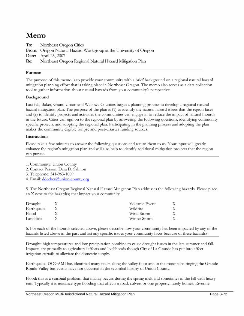
Memo To: Northeast Oregon Cities From: Oregon Natural Hazard Workgroup at the University of Oregon Date: April 25, 2007 Re: Northeast Oregon Regional Natural Hazard Mitigation Plan
Purpose
The purpose of this memo is to provide your community with a brief background on a regional natural hazard mitigation planning effort that is taking place in Northeast Oregon. The memo also serves as a data collection tool to gather information about natural hazards from your community’s perspective.
Background
Last fall, Baker, Grant, Union and Wallowa Counties began a planning process to develop a regional natural hazard mitigation plan. The purpose of the plan is (1) to identify the natural hazard issues that the region faces and (2) to identify projects and activities the communities can engage in to reduce the impact of natural hazards in the future. Cities can sign on to the regional plan by answering the following questions, identifying community specific projects, and adopting the regional plan. Participating in the planning process and adopting the plan makes the community eligible for pre and post-disaster funding sources.
Instructions
Please take a few minutes to answer the following questions and return them to us. Your input will greatly enhance the region’s mitigation plan and will also help to identify additional mitigation projects that the region can pursue. 1. Community: Union County 2. Contact Person: Dara D. Salmon 3. Telephone: 541-963-1009 4. Email: [email protected] 5. The Northeast Oregon Regional Natural Hazard Mitigation Plan addresses the following hazards. Please place an X next to the hazard(s) that impact your community. Drought X Earthquake X Flood X Landslide X
Volcanic Event X Wildfire X Wind Storm X Winter Storm X
6. For each of the hazards selected above, please describe how your community has been impacted by any of the hazards listed above in the past and list any specific issues your community faces because of these hazards? Drought: high temperatures and low precipitation combine to cause drought issues in the late summer and fall. Impacts are primarily to agricultural efforts and livelihoods though City of La Grande has put into effect irrigation curtails to alleviate the domestic supply. Earthquake: DOGAMI has identified many faults along the valley floor and in the mountains ringing the Grande Ronde Valley but events have not occurred in the recorded history of Union County. Flood: this is a seasonal problem that mainly occurs during the spring melt and sometimes in the fall with heavy rain. Typically it is nuisance type flooding that affects a road, culvert or one property, rarely homes. Riverine
Northeast Oregon Multi-Jurisdictional Natural Hazard Mitigation Plan Page S-72
flooding occurs during pineapple express events and can cause widespread and heavy damage to roads throughout the valley and to properties in La Grande, Island City, Elgin, Imbler, Union and the unincorporated county. These usually occur in the spring and the last one was the 96 flood. Landslide: this is a highly specific hazard that affects the south hills of La Grande. Events have not occurred for many years but can be triggered by heavy rain events. La Grande has a development code to deal with construction in these areas. Volcanic: the last event to affect Union County was the eruption of Mt. St. Helens which brought ash fallout that affected machinery and people’s breathing. Wildfire: this is the most prevalent hazard and has high impact areas throughout the unincorporated areas of Union County. The CWPP IDs these interface areas. Wind Storm: impacts throughout Union County during thunderstorms and winter storms. Impacts include power outages, drifting snow, closed freeways, tree blowdown. Winter Storm: impacts throughout Union County and can be made worse by heavy wind. Heavy snow usually does not pose widespread problems without the wind to drift it and close freeways and cause power outages.
7. Has the community taken any steps or implemented any projects to reduce the impact of hazards? If so, please explain. See Landslide for development ordinance and WF for CWPP. The utility (OTEC) has implemented mitigation projects using FEMA mitigation $ to strengthen power lines by installing additional poles to shorten spans. 8. Are there any risk reduction projects or activities that your community would like to implement? 1. Retrofit the Riveria building (currently used for the Kid’s Club) for EQ. 2. Address road elevation issues in the City of Elgin affected by high water events.
Northeast Oregon Multi-Jurisdictional Natural Hazard Mitigation Plan Page S-73
Date: March 3, 2007 Time: NA Location: NA Subject: Union County Planning Department Stakeholder Interview On March 3, 2007 Hanley Jenkins II, Union County Planning Director, completed the following survey on his own: General Questions
1. From your organization’s perspective, what hazard(s) pose the greatest threat to the community and why? Flood, ice storms, snowstorms, wildland fire
2. Does your organization maintain information or data on the impact of previous disasters? How so?
FEMA floodplain maps (FIRM) Community Vulnerability
Population 3. Are there certain populations within the community that might be at greater risk? Please explain…
Flood: residents adjacent or within floodplains Valley floor: severe wind & snow events
4. What organizations in the community provide services to special populations in the community?
County Emergency Management Department County Sheriff County Search & Rescue County Public Works Department
Economic Assets 5. How might natural hazards impact the local economy?
Impact to infrastructure: bridges, roads, power, sewer, water, etc. will affect the local economy.
6. Which businesses would be significantly impacted by the temporary loss of utilities? Boise Cascade Mills Trailer Manufacturing Facilities EOU
Cultural and Historic 7. Are there cultural or historic resources that are important to the community? What are they?
NA
Critical Facilities and Infrastructure 8. What critical facilities and infrastructure does your community rely on to function?
Roads, bridges, power, natural gas, water, sewer, storm water drainage, fire & police protection
Natural Resources 9. Could natural hazards impact environmental resources in your community? If so, how?
Flooding could change the drainage channel, cause erosion & sedimentation, and impact fisheries habitats.
Land Use and Development 10. Do you foresee population growth or change in your community? If so, where?
Northeast Oregon Multi-Jurisdictional Natural Hazard Mitigation Plan Page S-74

Average annual growth rate is projected at 0.7% over the next 18 years. Most growth will occur inside incorporated areas.
11. Are there existing developments in areas you think are subject to natural hazards? North La Grande Black Hawk Trail & Fruitdale Rd. area
a. What are the current and future development trends?
La Grande and Island City will receive 75% of the growth. Resources/Activities
12. Does your organization currently work in natural hazard mitigation? If yes, how? Yes, emergency services & public works
13. What role can your organization play in reducing risk in your community?
Floodplain overlay zone administration
14. Does your organization have any plans or policies that affect local residents, the economy, natural resources, or land use and development? Floodplain Overlay Zone administration; fire protection requirements within zone
Action Items
15. What activities do you think your community should take to reduce risk and prevent loss from future natural hazard events? (If you had the $, how would you spend it?) NA
a. Are there any activities your organization could do to reduce risk?
NA
16. In what ways would you like to see agencies, organizations or individuals in NE Oregon participate and coordinate to reduce risk from natural hazards? NA
a. What agencies or organizations in the community or the region do you think should be
involved in risk reduction activities in this community? NA
17. Can you think of other people or organizations we should contact?
NA
Northeast Oregon Multi-Jurisdictional Natural Hazard Mitigation Plan Page S-75
Date: March 27, 2007 Time: 11:00am – 11:30am Location: Wallowa County Courthouse Subject: Wallowa County Emergency Services Stakeholder Interview On March 27, 2007 Megan Findley met briefly with Paul Karvoski from Wallowa County Emergency Services in Enterprise, OR. The following document summarizes their discussion. Transmission lines come into Wallowa through the Hells Canyon Dam. The power lines that serve Wallowa come from Walla Walla, WA. The dam is a secondary source. Chief Joseph Days brings in 10,000 people for the last full week of July. The county would like to include Imnaha Woods in the CWPP wildland/urban interface assessment. Sheep Ridge – has sheriff’s dept. frequencies, hospital freq’s, weather data, TV translator, cell phone tower, internet, on the top of the hill behind the Courthouse – problems with those going down from wind, etc. There is one place in the county where all communication towers are located; it’s called Sheep Ridge. The sheriff’s department frequencies, hospital frequencies, weather data, TV translator, cell phone tower, and internet are located on the hill behind the Courthouse; the towers have sustained wind damage in the past, and transmission will occasionally go down.
Northeast Oregon Multi-Jurisdictional Natural Hazard Mitigation Plan Page S-76
Date: March 27, 2007 Time: 10:00am – 11:00am Location: Wallowa County Courthouse, Enterprise OR Subject: Lance Bailey, Wallowa County Planning Department Stakeholder Interview On March 27, 2007 Megan Findley interviewed Lance Bailey from the Wallowa County Planning Department in Enterprise, OR. The following document summarizes their discussion. Wallowa County issues permits within two zones at Wallowa Lake for short-term property rentals. ‘Short term’ applies to any rentals of 30 days or less. Lance would like to require property owners to renew their permits on a yearly basis so that the County can maintain data on the number of property rentals. The approval could be conditional upon a successful fire safety inspection (i.e., potential mitigation action). Wallowa Lake is a concern to Wallowa County for several reasons: 1) the recreation area at the head of the lake (south end) is at high risk of wildfire. Fuels have accumulated because the area has been without fire for 30-40 years. 2) The head of Wallowa Lake has only one access road. If wildfire occurs, residents and tourists may have difficulty evacuating, and emergency response teams will be limited as well. The county has pursued alternate access routes from the west side of the lake, but landowners have successfully prevented this from happening. 3) Wallowa Lake is at risk of dam failure. The dam is over 100 years old, and needs replacement as soon as possible. Similarly, homes at the south end of Wallowa Lake have been washed out by the Wallowa River in past years. Wallowa County could benefit from floodplain review. The county does not have a floodplain ordinance, and instead relies on FEMA to perform the review. If FEMA does not identify properties as within the floodplain (extent unknown), then the county does not regulate the land. Lance believes that there are areas along Hurricane Creek that are not listed in the floodplain and should be, including locations near the bridge (airport) that have been highly managed (dredged, burned, etc.). The composition of the population has changed, but the population count has remained steady. There appears to be population growth (construction), but what’s really happening is that more people are single and retired, and thus occupying more space than one family (four persons) living under the same roof might. There is one place in the county where all communication towers are located. In the past, radio stations have failed and the repeater was once down for three weeks straight. Measure 37 claims may cause issues in the future; there are parts of the county that may be hazardous if opened for development (i.e., top of the murrain by Wallowa Lake, and/or windy sections of the valley floor). Wallowa County would like to create another section within the CWPP to include an assessment of Imnaha Woods. The Department of Forestry will take the lead. The Wallowa County State Parks Master Plan lists a number of projects. Chris Perkins would be my contact, should I inquire about this plan.
Northeast Oregon Multi-Jurisdictional Natural Hazard Mitigation Plan Page S-77
Memo To: Community Stakeholders in Northeast Oregon From: Oregon Natural Hazard Workgroup at the University of Oregon Date: April 24, 2007 Re: Northeast Oregon Regional Natural Hazard Mitigation Plan
Purpose
The purpose of this memo is to provide your organization with a brief background on a regional natural hazard mitigation planning effort that is taking place in Northeast Oregon. The memo also serves as a data collection tool to gather information about natural hazards from your organization’s perspective.
Background
Last fall, Baker, Grant, Union and Wallowa Counties began a planning process to develop a regional natural hazard mitigation plan. The purpose of the plan is (1) to identify the natural hazard issues that the region faces and (2) to identify projects and activities the communities can engage in to reduce the impact of natural hazards in the future. This mitigation planning process is greatly enhanced when special districts and community organizations are involved and can provide additional information.
Instructions
Please take a few minutes to answer the following questions and return them to us by Wednesday, May 2nd. Your input will greatly enhance the region’s mitigation plan and will also help to identify additional mitigation projects that the region can pursue. 1. Organization: Wallowa Resources 2. Contact Person: Nils Christoffersen 3. Telephone: (541) 426-8053 ext 25 4. Email: [email protected] 5. The Northeast Oregon Regional Natural Hazard Mitigation Plan addresses the following hazards. Please replace the box(es) with Xs next to the hazard(s) that your organization is most concerned about. Drought Earthquake Flood Landslide
Volcanic Event Wildfire Wind Storm Winter Storm
6. Briefly describe why these hazards are of concern for your organization. Please be as specific as possible. Wildfire risk in Wallowa County has been an issue of increasing concern since the late 1970’s when forest ecologists started documenting changing forest conditions that increased the probability of severe wildfire events. Since 1986, Wallowa County has experienced recurring large-scale wildfire events that pose threats to our natural resources, community, public health and safety and economic development opportunities. There is particular concern about fire in our highest density recreation areas and specific wildland urban interface areas where transportation systems are limited and pose constraints to emergency evacuation. Until the Wallowa Lake Dam is repaired or replaced, there is also concern about potential dam failure and flooding of the upper valley.
Northeast Oregon Multi-Jurisdictional Natural Hazard Mitigation Plan Page S-78

7. Please describe how your organization has been impacted by any of the hazards listed above in the past? (For example - loss of power, closure of transportation systems, damage to property, etc. Please be as specific as possible). The only direct impact to our organization is occasional air quality impacts during wildfire events.
8. What role can your organization play in reducing risk from natural hazards in your community? Wallowa Resources is an active member of the Wallowa County Natural Resources Advisory Committee and Chairs the Wallowa County Community Wildfire Protection Plan sub-committee. Wallowa Resources is also an active partner with both USFS and ODF on forest health projects, including forest condition assessments, fuel reduction and defensible space activities.
9. Are there any risk reduction projects that your organization would like to implement that would directly benefit your organization, your facilities or your employees? Anything advances our efforts to get ahead of the accelerating forest health concerns – specifically continued increases in standing and downed dead wood – would be beneficially. USFS has spent over $18 million on fire suppression in Wallowa County since 2000. Some increase in money invested in forest management prior to fire would pay dividends to the forest and community. This would also have a local and regional atmospheric benefit as well.
10. Are there any risk reduction projects that your organization would like to see implemented that would benefit the community in general? Priorities identified in Wallowa County Community Wildfire Protection Plan, which is available on line. In addition to comment above, we do need to find a solution for the Wallowa Lake Dam.
Northeast Oregon Multi-Jurisdictional Natural Hazard Mitigation Plan Page S-79
Memo To: Community Stakeholders in Northeast Oregon From: Oregon Natural Hazard Workgroup at the University of Oregon Date: April 24, 2007 Re: Northeast Oregon Regional Natural Hazard Mitigation Plan
Purpose
The purpose of this memo is to provide your organization with a brief background on a regional natural hazard mitigation planning effort that is taking place in Northeast Oregon. The memo also serves as a data collection tool to gather information about natural hazards from your organization’s perspective.
Background
Last fall, Baker, Grant, Union and Wallowa Counties began a planning process to develop a regional natural hazard mitigation plan. The purpose of the plan is (1) to identify the natural hazard issues that the region faces and (2) to identify projects and activities the communities can engage in to reduce the impact of natural hazards in the future. This mitigation planning process is greatly enhanced when special districts and community organizations are involved and can provide additional information.
Instructions
Please take a few minutes to answer the following questions and return them to us by Wednesday, May 2nd. Your input will greatly enhance the region’s mitigation plan and will also help to identify additional mitigation projects that the region can pursue. 1. Organization: Wallowa SWCD 2. Contact Person: Cynthia Warnock 3. Telephone: 541 426-4521 ext. 106 4. Email: [email protected] 5. The Northeast Oregon Regional Natural Hazard Mitigation Plan addresses the following hazards. Please replace the box(es) with Xs next to the hazard(s) that your organization is most concerned about. Drought X Earthquake Flood X Landslide X
Volcanic Event Wildfire X Wind Storm Winter Storm
6. Briefly describe why these hazards are of concern for your organization. Please be as specific as possible. The Wallowa SWCD assists landowners with technical advice for natural resources as well as helping them with permits, grant application etc. We have seen the floods and landslides and have had numerous requests for help.
Northeast Oregon Multi-Jurisdictional Natural Hazard Mitigation Plan Page S-80