Appendix 10 - info.gov.hk
37
Appendix 10 DRAINAGE IMPACT ASSESSMENT
Transcript of Appendix 10 - info.gov.hk
Appendix 10
DRAINAGE IMPACT ASSESSMENT

Master Mind Development Limited
. .
Proposed Sai Kung Pak Lap Nature Education Park
Drainage Impact Assessment
Project Profile Report
June 2021

Page i
Drainage Impact Assessment – Project Profile Report
Proposed Sai Kung Pak Lap Nature Education Park
AIM Group Limited
C184 DIA Report 210618.doc
Contents
1 Introduction ............................................................................................................... 1
1.1 Background .................................................................................................................. 1
1.2 Information Available for the Study .............................................................................. 1
2 Project Outline ........................................................................................................... 1
2.1 Project Title .................................................................................................................. 1
2.2 Proponent ..................................................................................................................... 1
2.3 Contact Person ............................................................................................................. 1
2.4 Nature and Description of the Project........................................................................... 2
2.5 Planning Application ..................................................................................................... 2
2.6 Location ........................................................................................................................ 2
3 Planning and Implementation Programme ............................................................. 2
3.1 Planning and Implementation ....................................................................................... 2
3.2 Project Timetable ......................................................................................................... 2
3.3 Interface with Other Projects ........................................................................................ 3
4 Existing Drainage ...................................................................................................... 3
4.1 Existing Drainage Routes and Conditions .................................................................... 3
5 Drainage Impact Assessment .................................................................................. 3
5.1 Drainage Impact Assessment ...................................................................................... 3
5.2 Drainage Impact ........................................................................................................... 4
5.3 Potential Mitigation Measures ...................................................................................... 6
6 Conclusions ............................................................................................................... 9

Page ii
Drainage Impact Assessment – Project Profile Report
Proposed Sai Kung Pak Lap Nature Education Park
AIM Group Limited
C184 DIA Report 210618.doc
APPENDICES
Appendix A
Master Layout Plan
Appendix B
Site Photographs
Appendix C
Runoff Calculations
Appendix D
Hydraulic Capacity Calculations
Appendix E
Figures
Figure 1 - Site Location
Figure 2 - Overall Catchment Area
Figure 3 - Local Drainage Channels
Page 1
Drainage Impact Assessment – Project Profile Report
Proposed Sai Kung Pak Lap Nature Education Park
AIM Group Limited
C184 DIA Report 210618.doc
1 Introduction
1.1 Background
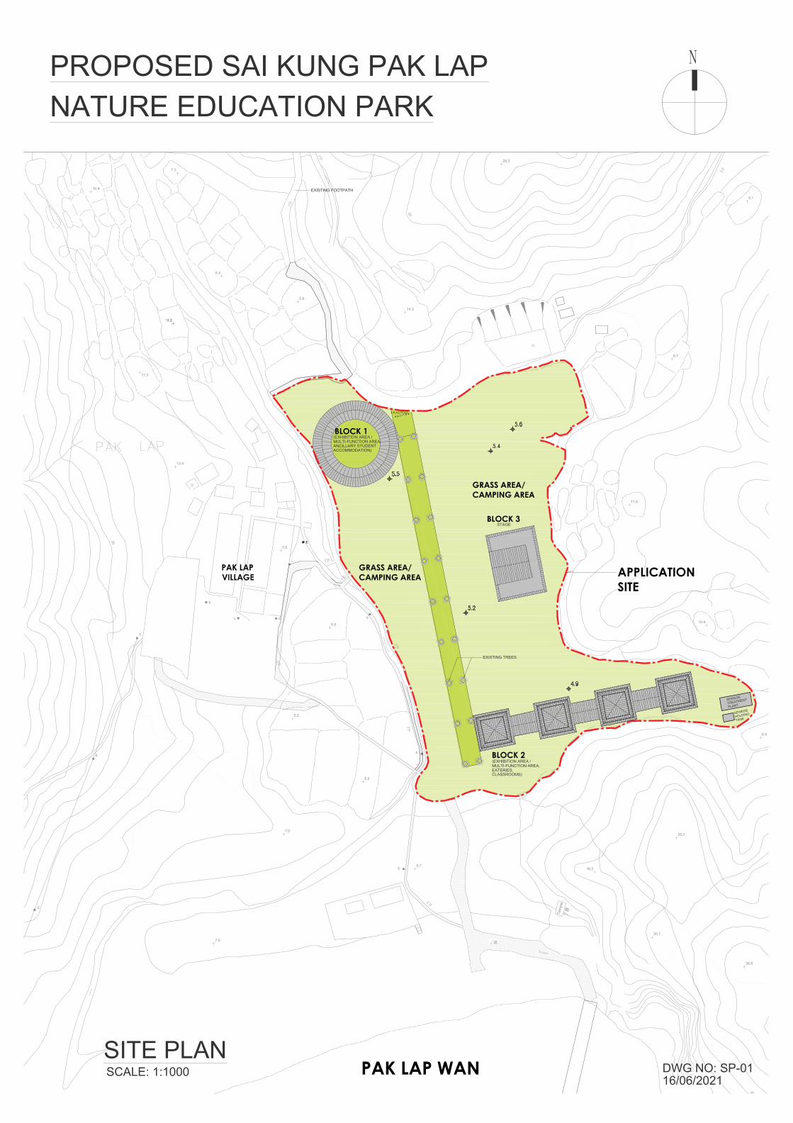
1.1.1 This Drainage Impact Assessment (DIA) has been prepared in support of a Section 16 (S16) Application to the Town Planning Board (TPB) for the proposed Sai Kung Pak Lap Nature Education Park at Pak Lap, Sai Kung.
1.1.2 The Site is to be developed to provide a nature educational park with ancillary simple overnight accommodation. Master Layout Plans are included in Appendix A.
1.1.3 This Report assesses the drainage impacts in the vicinity of the Site as a result of the proposed development.
1.1.4 This Report has been prepared in accordance with the requirements of the DIA process for private sector projects set out under Drainage Services Department’s (DSD’s) Technical Advice Note No. 1.
1.2 Information Available for the Study
1.2.1 Reference has been made to Drainage Services Departments DSD’s Stormwater Drainage Manual (SDM), 5th Edition, and public drainage information presented on Land’s Department’s GeoInfo Map website.
1.2.2 Reference has also been made to a topographic survey carried out for this Project.
2 Project Outline
2.1 Project Title
2.1.1 The project title is “Proposed Sai Kung Pak Lap Nature Education Park”. The location of the Site is shown on Figure 1.
2.2 Proponent
2.2.1 The proponent of the project is Master Mind Development Limited.
2.3 Contact Person
2.3.1 For issues relating to this DIA Study, please contact Ir Colin Moreby of AIM Group Limited at 2572 6533.
Page 2
Drainage Impact Assessment – Project Profile Report
Proposed Sai Kung Pak Lap Nature Education Park
AIM Group Limited
C184 DIA Report 210618.doc
2.4 Nature and Description of the Project
2.4.1 The Application Site has an area of about 13,990m2 and is within an area currently zoned “Agriculture” under the draft Outline Zoning Plan (OZP) for Pak Lap (No. No. S/SK-PL/3), while lands in the vicinity of the site are zoned as “Conservation Area” and “Village Type Development”.
2.4.2 The Application Site is rural in nature, which is bounded by a footpath to the west and north and by mainly vegetation to the east and south. A number of low-rise residential houses are located west and north of the Application Site.
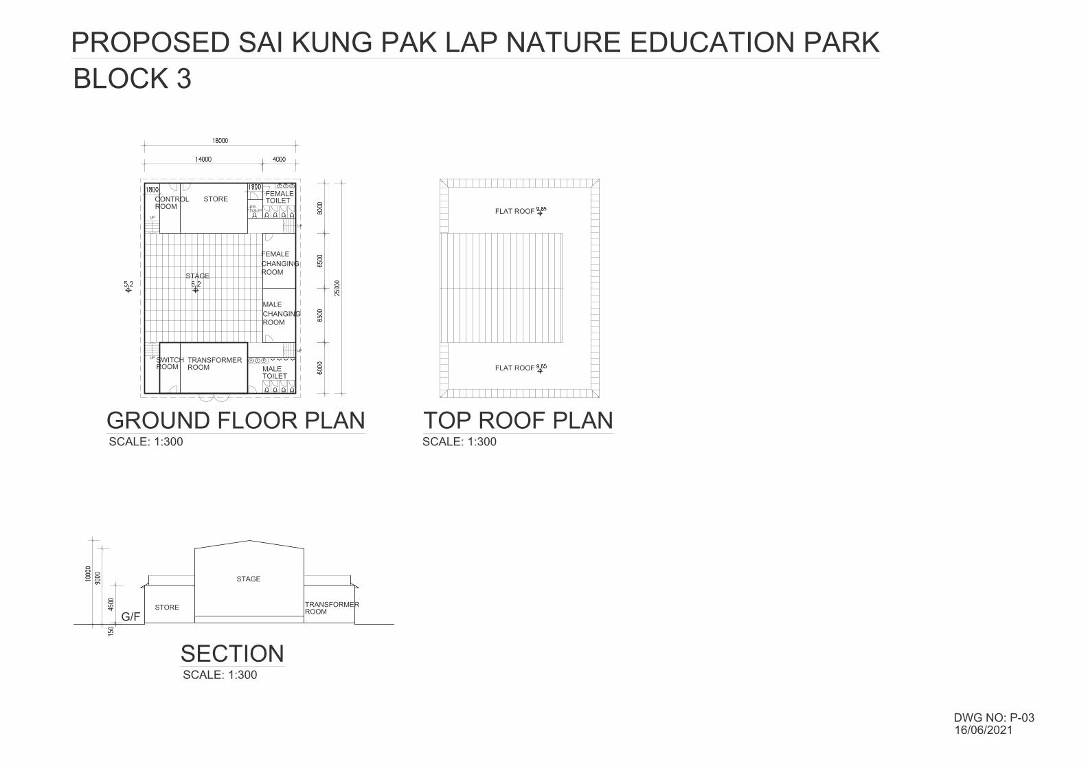
2.4.3 Based on the current design scheme, two 4-storey building blocks (Block 1 and Block 2) comprising exhibition/multi-function areas, ancillary overnight accommodation, eateries and classrooms and a 1-storey building block (Block 3) will be provided.
2.5 Planning Application
2.5.1 This DIA Report has been prepared in support of a S16 Submission to the TPB.
2.6 Location
2.6.1 The Application Site is located to the east of Pak Lap Village, approximately 600m to the south of Sai Kung Man Yee Road.
3 Planning and Implementation Programme
3.1 Planning and Implementation
3.1.1 The proposed development will be planned and implemented under the supervision of appropriately qualified and experienced professionals. The construction of any works for the proposed development will be carried out by a suitable Contractor.
3.2 Project Timetable
3.2.1 The Development is expected to be complete by late 2024.
Page 3
Drainage Impact Assessment – Project Profile Report
Proposed Sai Kung Pak Lap Nature Education Park
AIM Group Limited
C184 DIA Report 210618.doc
3.3 Interface with Other Projects
3.3.1 There is no foreseeable direct interaction with other development projects in the area, which should be considered at this time.
4 Existing Drainage
4.1 Existing Drainage Routes and Conditions
4.1.1 The Site is located within a large (approximately 467,028m2) overall catchment (see Figure 2), with the overall catchment made up of 3 main sub-catchments (Catchments A, B and C). Also shown on Figure 2 are the main drainage routes for the main sub-catchments, with the main drainage channel running immediately to the west of the Site. The channels connect close to the south-western corner of the Site, before running westwards and discharging at the western end of the beach. Photographs of the existing Site and surrounding areas are included in Appendix B.
4.1.2 The main drainage channel is a formed, approximately trapezoidal section, with an earth bottom and rubble walls. There are also some short weirs across the channel. The main drainage channel running westwards along the rear of the beach is a natural streamcourse with some stony sections.
4.1.3 It should be noted that the Site would have historically been a natural flood (storage) basin for the area.
5 Drainage Impact Assessment
5.1 Drainage Impact Assessment
General
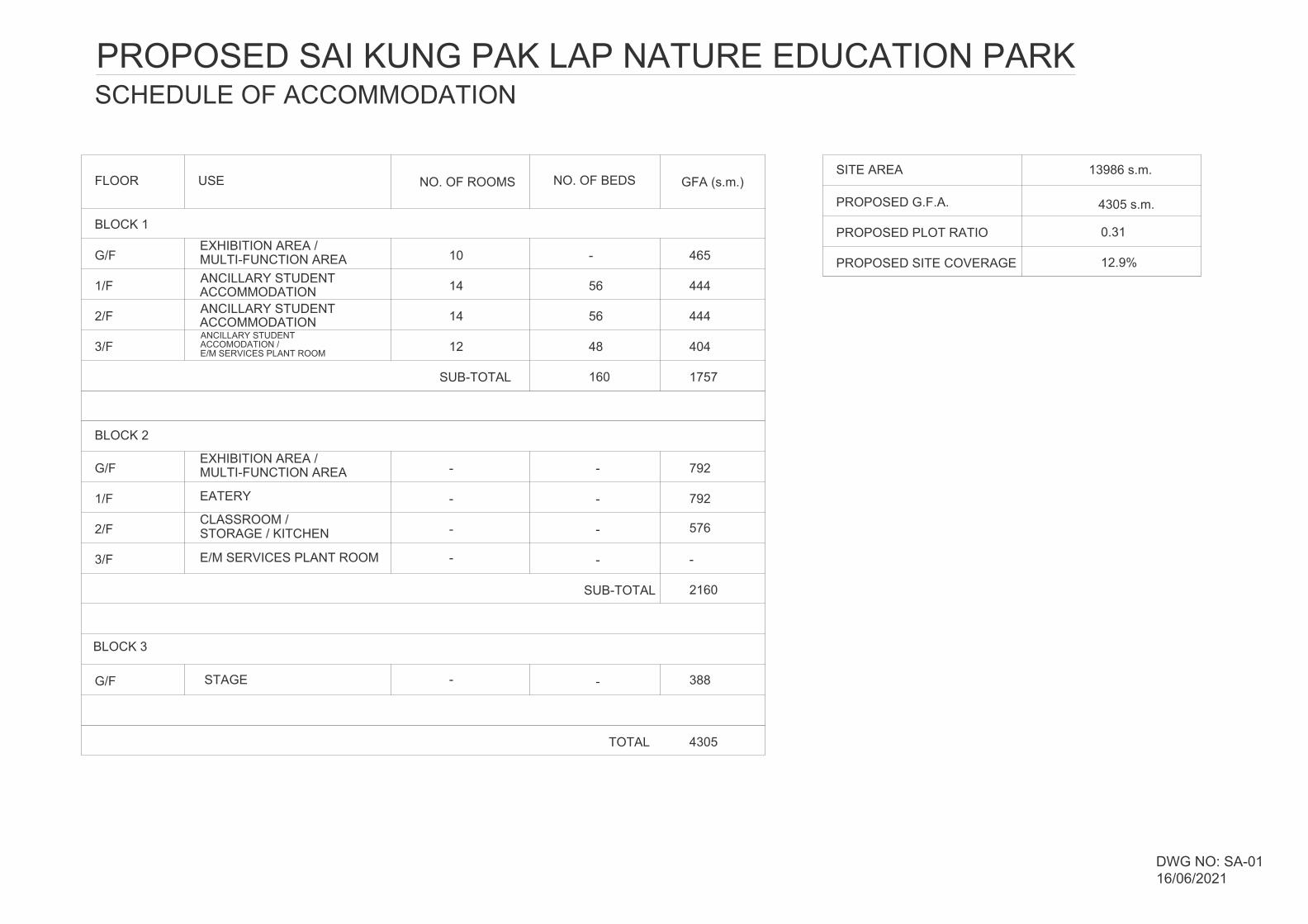
5.1.1 The Master Layout Plan (MLP) for the proposed development includes three buildings, Blocks 1, 2 and 3, as well as a sewage treatment plant and a sewage holding tank. However, the proposed Site Coverage is only 12.9% (approximately 1,805m2), with the remainder being retained as flat vegetation (grass).
5.1.2 The Site coverage represents only approximately 0.4% of the overall Catchment Area ad the increased runoff as a result of the new buildings
Page 4
Drainage Impact Assessment – Project Profile Report
Proposed Sai Kung Pak Lap Nature Education Park
AIM Group Limited
C184 DIA Report 210618.doc
will therefore be minimal. The key issue for this DIA is the likely situation under extreme rainfall events.
Assessment Criteria
5.1.3 As the catchment areas are all fairly small, the Rational Method (as set out in Section 7.5.2 of the SDM) has been used for the calculation of runoff.
5.1.4 The 1 in 50-year scenario has been considered, as the Site will drain to a main rural drainage channel. However, 1 in 2-year and 1 in 10-year scenarios have also been included for reference.
5.1.5 Allowances for increased rainfall intensity up to mid-21st Century have been included in the runoff calculations, in accordance with Section 6.8 of the DSD Stormwater Drainage Manual (SDM). Increased tide levels have also been considered.
5.1.6 Manning’s Equation has been used for the assessment of the capacity of the main streamcourse.
5.2 Drainage Impact
Increased Runoff
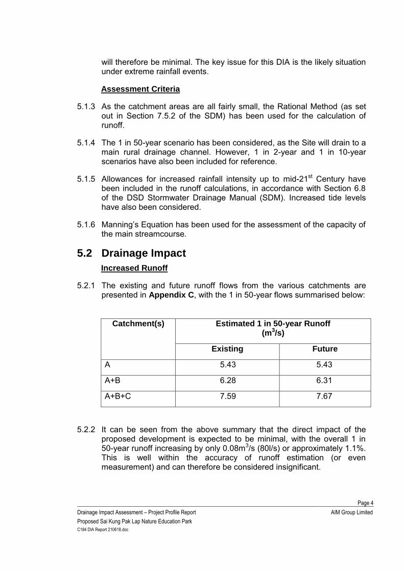
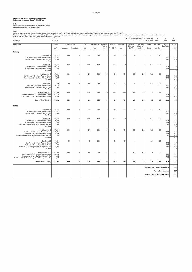
5.2.1 The existing and future runoff flows from the various catchments are presented in Appendix C, with the 1 in 50-year flows summarised below:
Catchment(s) Estimated 1 in 50-year Runoff (m3/s)
Existing Future
A 5.43 5.43
A+B 6.28 6.31
A+B+C 7.59 7.67
5.2.2 It can be seen from the above summary that the direct impact of the proposed development is expected to be minimal, with the overall 1 in 50-year runoff increasing by only 0.08m3/s (80l/s) or approximately 1.1%. This is well within the accuracy of runoff estimation (or even measurement) and can therefore be considered insignificant.
Page 5
Drainage Impact Assessment – Project Profile Report
Proposed Sai Kung Pak Lap Nature Education Park
AIM Group Limited
C184 DIA Report 210618.doc
Drainage Channel Capacities
5.2.3 Although the proposed development will only result in minimal increases in runoff, it is also necessary to consider the existing drainage channel capacities and the likely conditions during storm events. Hydraulic calculations for the capacities of the main channels are included in Appendix D. It should be noted that all of the main drainage channels are outside the Application Site.
5.2.4 At the downstream end of Catchment A (a short distance to the north of the Site) there is a pond with an overflow weir into the main channel. The pond will provide some attenuation (i.e. there will be some temporary storage and the peak discharge will be slightly reduced). An initial assessment of the pond retention indicates that the peak flow is not significantly reduced, particularly because the water level will rise and spill over various sections of the downstream embankment. Retention in the pond has therefore been ignored for the purposes of this DIA.
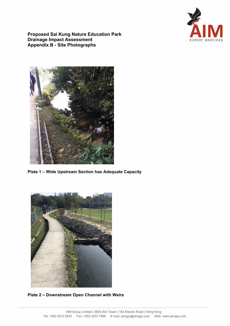
5.2.5 The weir (at the pond) discharges into a fairly wide open-channel (see Plate 1, Appendix B). The most upstream section of the channel has adequate capacity (approximately 5.66m3/s) for even the 1 in 50-year peak discharge, particularly considering the (small) retention in the pond.
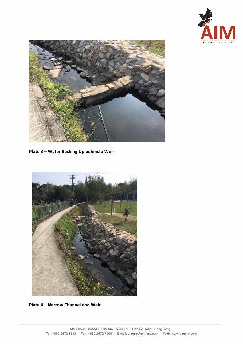
5.2.6 Further downstream, particularly from the footbridge access to the village onwards, the channel gets significantly narrower, with the capacity reducing to less than 2m3/s in places. However, the capacity of the channel is even further reduced by a series of weirs across the channel (see Plates 2 to 4). This means that the flow will back up behind the weirs before overflowing, rather than flowing smoothly, as in a normal open channel. The capacity over the weirs (without flooding out of the channel) is only approximately 1.5m3/s, i.e. much less than the expected peak flows.
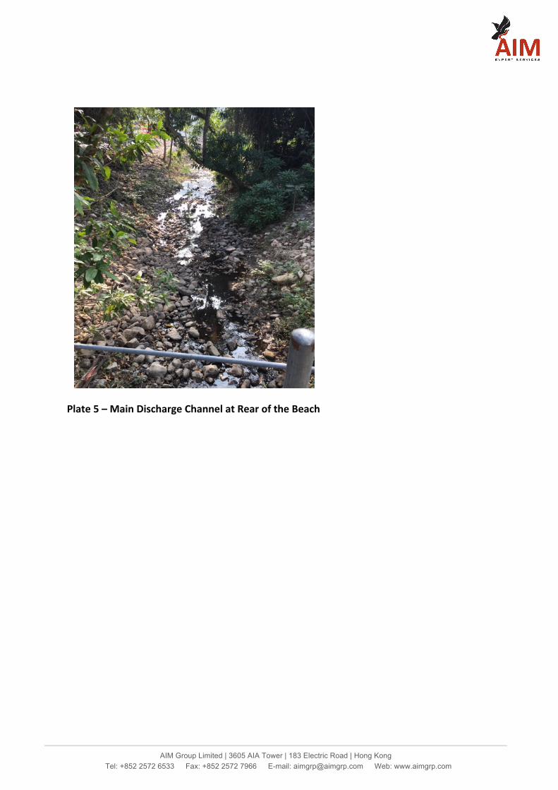
5.2.7 Further downstream, to the south-west of the Site, the flows from all 3 sub-catchments converge and discharge into a very stony rough open channel at the rear of the beach (see Plate 5). Based on assumed dimensions and levels, the main channel has generally adequate capacity for the overall peak flows, although there may be some sections which will not have adequate capacity. A further factor is that the main channel discharges into the sea and the hydraulic conditions in the channel will be tidally affected.
5.2.8 The channel serving Catchment C comprises a simple trapezoidal earth channel running along the eastern and southern Site boundaries. The capacity of the channel is less than the expected peak flow. This channel could probably be classed as village drainage, with a 1 in 10-year rainfall
Page 6
Drainage Impact Assessment – Project Profile Report
Proposed Sai Kung Pak Lap Nature Education Park
AIM Group Limited
C184 DIA Report 210618.doc
as the assessment criteria), although it would still have inadequate capacity.
Expected Conditions Under Peak Flows
Main Discharge Channel
5.2.9 Under the tide and rainfall assessment combinations set out in the DSD SDM, there will be flooding at the upstream end of the main discharge channel. It is not expected to be deep, but it could be extensive, as the surrounding ground levels are quite flat. The narrow section at the footbridge would cause local increased flooding
Main Channel Adjacent to the Site
5.2.10 The main channel adjacent to the Site is much more complex to assess, particularly due to the multiple weirs and also the likelihood of flooding, both into the Site and also towards Pak Lap Village. The levels on each side of the channel are broadly similar and it is expected that, as the channel capacity is exceeded, the water level will continue to rise and spill over into the flat area between the stream and the village. However, when it rises above the level of the footpath on the eastern side of the channel, it will spill over into the Site, which is lower than the footpath, i.e. the footpath will effectively act as an overflow weir. As shown on Figure 3, the capacity just before the footpath is flooded is only 2.96m3/s, while to peak flow is expected to be 6.31m3/s. As the Site is flat, the flooding is expected to be extensive, although probably not deep.
Channel for Catchment C
5.2.11 The channel serving Catchment C has a capacity in the order of 0.8m3/s, compared to a 1 in 10-year runoff of 1.09m3/s, so there will be some minor flooding. Although the flooding will not be severe, it will add to the overall problems.
5.3 Potential Mitigation Measures
Channel Improvement/New Drains
5.3.1 The most common solution for drainage capacity problems is to provide new or enlarged drainage facilities. However, in this case, any new drainage systems would need to be substantial and, importantly, would need to be constructed outside the Site boundary, which would be be beyond the scope of this current Application.
5.3.2 There would be the alternative option to provide new drainage systems within the Site. However, any new drains would simply transfer the flows
Page 7
Drainage Impact Assessment – Project Profile Report
Proposed Sai Kung Pak Lap Nature Education Park
AIM Group Limited
C184 DIA Report 210618.doc
faster than under existing conditions and would therefore adversely affect the downstream hydraulic conditions.
Storage
5.3.3 The Site currently provides flood storage, when any flows spill over from the main channel and/or back up from the main discharge channel behind the beach, and it would be possible to provide this storage in a more controlled manner, either with an open storage “pond/lake/lagoon” or by providing an underground tank. However, an initial simplified assessment of the flows indicates that an overall storage volume of 2,800m3 would need to be provided for the excess flows from Catchments A and B alone. It is noted that the actual volume required might be changed by a detailed computer modelling exercise, but it is likely to be of the same order of magnitude.
5.3.4 It can be argued that the whole area currently floods anyway, so this Project should only be responsible for the volume of storage currently provided with the Site. However, even if the volume could be, say, halved, the tank would still be a major structure. Any smaller storage volume would only resolve part of the flooding issue.
5.3.5 A pond or tank of the capacity required (e.g. 2m deep x 100m long x 14m wide) would occupy a very large proportion of the Site and would probably be extremely expensive to construct, particularly as an underground tank (N.B. the Site has a very high groundwater table, so an underground tank would need to be massive to withstand the upthrust).
5.3.6 One further consideration is that any storage facility would need to be pumped out after any major storm event and this would represent an ongoing operational and maintenance liability.
5.3.7 Overall, the storage option is not considered to be practical/feasible.
Raised Ground Levels
5.3.8 A further option to protect the Site would be to elevate the ground levels, above any likely flood levels. However, this would remove the existing flood storage at the Site and make the flooding elsewhere (e.g. the village) even worse. This would not be acceptable.
5.3.9 One variation to this option would be to simply elevate the buildings (possibly on columns) and provide raised walkways between them. The depth of flooding is probably not great (almost certainly much less than 1m), so the buildings would not need to elevated by much. This would allow the existing temporary flooding to continue and maintain the existing flood storage volume, thus providing valuable flood protection for
Page 8
Drainage Impact Assessment – Project Profile Report
Proposed Sai Kung Pak Lap Nature Education Park
AIM Group Limited
C184 DIA Report 210618.doc
nearby areas, such as the village. It is noted that this arrangement is not uncommon internationally.
Polder Scheme
5.3.10 Polder schemes essentially involve isolating a particular area from the surrounding drainage systems (with embankments and/or walls) and providing pumps to deal with the runoff from within the isolated area. These arrangements have been used successfully for some village areas in the New Territories. However, the most significant issues are that the existing flood storage within the Site would be lost and the pumped discharge from the Site would affect the drainage conditions in the surrounding areas. Both of these impacts would be unacceptable.
5.3.11 A further consideration is that there would be a significant on-going operational and maintenance liability.
Proposed Mitigation Option
5.3.12 The proposed option for the Site is to elevate the buildings above any potential flood level (including allowance for freeboard) and simply allow the existing temporary flooding at the Site to continue (as it has done for decades, at least). This approach would have minimal impact on the current drainage regimes in the area and, importantly, would maintain the existing flood storage at the Site, which provides valuable flood protection for nearby areas, including the village.
5.3.13 Accurate assessment of likely flood levels would require complex modelling and it would be inappropriate to attempt such an exercise at this early stage of implementation. It is proposed that detailed assessments would be carried out in later stages of implementation, when further details of the proposed development would be available. Any such detailed assessments would need to consider both increased rainfall intensity and higher tide levels as a result of global warming, as set out in the SDM.
Page 9
Drainage Impact Assessment – Project Profile Report
Proposed Sai Kung Pak Lap Nature Education Park
AIM Group Limited
C184 DIA Report 210618.doc
6 Conclusions
6.1.1 There will be a very small (insignificant) increase in the volume of runoff from the Site as a result of the Proposed Development.
6.1.2 The existing main drains in the area are already under-capacity. However, they are all located outside the Application Site and cannot be upgraded.
6.1.3 The Site floods temporarily under severe rainstorm events and thus provides valuable flood storage and flood protection for surrounding areas.
6.1.4 The overall drainage concept is to continue to allow flooding of the Site, with the buildings to be designed to be above any flood level. This approach will maintain the flood storage at the Site and therefore maintain the flood protection to surrounding areas.
6.1.5 A detailed analysis of the hydraulic conditions and potential flood levels would require complex modelling and would therefore be inappropriate for an initial DIA such as this. Further assessments would be required in later stages of Project implementation.
6.1.6 There will be no unacceptable increases to the risks of flooding at the Site or in surrounding areas and no unacceptable adverse drainage impacts.

Appendix A Master Layout Plan
PAK LAP WAN
4 FLAG POSTS
(EXHIBITION AREA /MULTI-FUNCTION AREA,
ACCOMMODATION)
16/06/2021
Tem
ple
20
20
20
L
E
EL E
E
E
E
E
E
E
EXISTING FOOTPATH
(EXHIBITION AREA /MULTI-FUNCTION AREA,EATERIES,CLASSROOMS)
SITE PLANSCALE: 1:1000 DWG NO: SP-01
PLANTTREATMENTSEWEGE
TANKHOLDINGSEWEGE
EXISTING TREES
STAGE
ANCILLARY STUDENT
PROPOSED SAI KUNG PAK LAPNATURE EDUCATION PARK

GROUND FLOOR PLANSCALE: 1:300
16/06/2021
EXHIBITION AREA /MULTI-FUNCTION AREA
BLOCK 1
FIRST FLOOR PLAN ~
EXHIBITION AREA /MULTI-FUNCTION AREA
ACCOMMODATION
G/F
1/F
2/F
3/F
SECTIONSCALE: 1:300
ELEC.
ACCOMMODATION
VOID
ACCOMMODATION
VOID
ROOMPLANTA/C
ROOMPUMP
ACCOMMODATION
ROOM
WATERMETERROOM
EXIT
MAIN ENTRANCE
SECONDARY ENTRANCE
ELEC.METER
METERROOM
TEL.ROOM
TEL.ROOM
METERROOM
WATER
TANKWATER
WATER
ROOMPLANTA/C
TEL.ROOM
TOP ROOF PLANSCALE: 1:300
ROOM
ELEC.METERROOM
NO. OF ROOMS : 10
NO. OF ROOMS : 14
NO. OF ROOMS : 12
DWG NO: P-01
SCALE: 1:300
SECOND FLOOR PLAN SCALE: 1:300
THIRD FLOOR PLAN
STUDENTANCILLARY
STUDENTANCILLARY
ANCILLARY STUDENT
ANCILLARY STUDENT
ACCOMMODATIONANCILLARY STUDENT
PROPOSED SAI KUNG PAK LAP NATURE EDUCATION PARK

GROUND FLOOR PLANSCALE: 1:400
FIRST FLOOR PLAN
SECOND FLOOR PLAN
TOP ROOF PLAN
EXHIBITION AREA /MULTI-FUNCTION AREA
KITCHENFEMALE
LAV.
D.LAV.
THIRD FLOOR PLAN
SCALE: 1:400
SCALE: 1:400
SCALE: 1:400
SCALE: 1:400
EXHIBITION AREA /
MULTI-FUNCTION AREA
G/F
1/F
2/F
3/F
SECTIONSCALE: 1:400
EXHIBITION AREA /
MULTI-FUNCTION AREA
EXHIBITION AREA /
MULTI-FUNCTION AREA
EXHIBITION AREA /
MULTI-FUNCTION AREA
BLOCK 2
16/06/2021DWG NO: P-02
ROOMPLANT
A/C
ROOMPUMP
TANKWATER
ROOMPLANTA/C
PROPOSED SAI KUNG PAK LAP NATURE EDUCATION PARK
D.LAV.
D.LAV. MALE
LAV.
KITCHEN
KITCHEN
EXHIBITION AREA /MULTI-FUNCTION AREA
KITCHENFEMALELAV.
D.LAV.
ROOMPLANTA/C
ROOMPUMP
TANKWATER
ROOMPLANT
A/C
D.LAV.
D.LAV.MALE
LAV.
KITCHEN
D.LAV.
KITCHEN
LAV.D.LAV.LAV.
GROUND FLOOR PLANSCALE: 1:300
ROOMCHANGINGFEMALE
ROOMCHANGINGMALE
STORE
SWITCHROOM
TOILETFEMALE
TOILETMALE
G/F
SECTIONSCALE: 1:300
STORE
BLOCK 3
TOP ROOF PLANSCALE: 1:300
16/06/2021DWG NO: P-03
CONTROLROOM
ROOMTRANSFORMER
ROOMTRANSFORMER
UP
UP
UP
DIS.TOILET
UP
FLAT ROOF
FLAT ROOF
PROPOSED SAI KUNG PAK LAP NATURE EDUCATION PARK
SCHEDULE OF ACCOMMODATION
FLOOR NO. OF ROOMS
G/F
GFA (s.m.)
1/F
2/F
SUB-TOTAL
BLOCK 1
USE
EXHIBITION AREA /MULTI-FUNCTION AREA 10 465
14 444
14 444
1757
G/F - 792
BLOCK 2
TOTAL 4305
16/06/2021
SITE AREA
PROPOSED G.F.A.
13986 s.m.
4305 s.m.
PROPOSED PLOT RATIO 0.31
ACCOMMODATION
3/F 12 404E/M SERVICES PLANT ROOM
NO. OF BEDS
56
48
-
56
ACCOMODATION /
160
-
-1/F 792
SUB-TOTAL 2160
EXHIBITION AREA /MULTI-FUNCTION AREA
PROPOSED SITE COVERAGE 12.9%
-2/F
-3/F -
EATERY -
- 576CLASSROOM /
E/M SERVICES PLANT ROOM -
DWG NO: SA-01
BLOCK 3
G/F STAGE -- 388
ANCILLARY STUDENT
ACCOMMODATIONANCILLARY STUDENT
ANCILLARY STUDENT
PROPOSED SAI KUNG PAK LAP NATURE EDUCATION PARK
STORAGE / KITCHEN

Appendix B Site Photographs
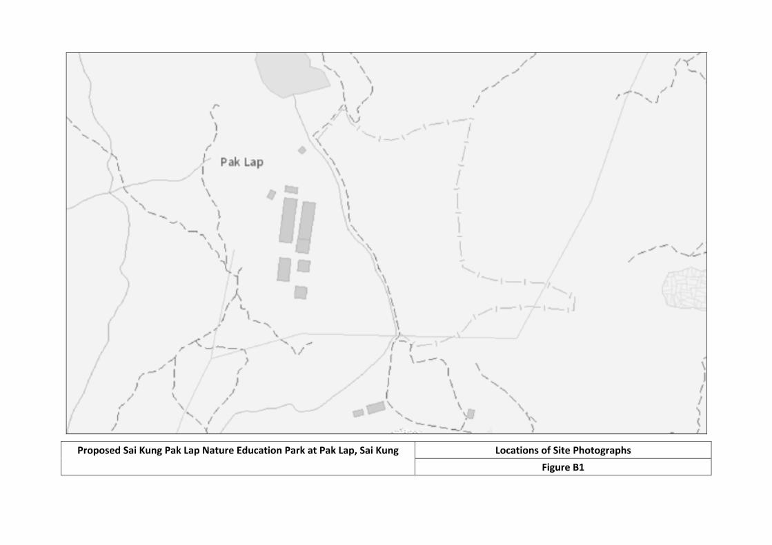
Proposed Sai Kung Pak Lap Nature Education Park at Pak Lap, Sai Kung Locations of Site Photographs Figure B1
colinmoreby
Line
colinmoreby
Line
colinmoreby
Line
colinmoreby
Line
colinmoreby
Line
colinmoreby
Text Box
1
colinmoreby
Text Box
2
colinmoreby
Text Box
3
colinmoreby
Text Box
4
colinmoreby
Text Box
5
colinmoreby
Text Box
Proposed Sai Kung Pak Lap Nature Education Park
AIM Group Limited | 3605 AIA Tower | 183 Electric Road | Hong Kong Tel: +852 2572 6533 Fax: +852 2572 7966 E-mail: [email protected] Web: www.aimgrp.com
Proposed Sai Kung Nature Education Park Drainage Impact Assessment Appendix B - Site Photographs
Plate 1 – Wide Upstream Section has Adequate Capacity
Plate 2 – Downstream Open Channel with Weirs
AIM Group Limited | 3605 AIA Tower | 183 Electric Road | Hong Kong Tel: +852 2572 6533 Fax: +852 2572 7966 E-mail: [email protected] Web: www.aimgrp.com
Plate 3 – Water Backing Up behind a Weir
Plate 4 – Narrow Channel and Weir
AIM Group Limited | 3605 AIA Tower | 183 Electric Road | Hong Kong Tel: +852 2572 6533 Fax: +852 2572 7966 E-mail: [email protected] Web: www.aimgrp.com
Plate 5 – Main Discharge Channel at Rear of the Beach

Appendix C Runoff Calculations

1 in 2 year
Proposed Sai Kung Pak Lap Education ParkCatchment Areas and Run-off (1 in 2 Year)
Refer:DSD Stormwater Drainage Manual (SDM, 5th Edition)Refer to Figure 2 for Catchment Areas
Notes:Adjacent Catchments comprise mostly unpaved steep upland areas (C = 0.35), with old villages housing at Pak Lap Tsuen and some minor footpaths (C = 0.85)The future development will comprise buildings (C = 1.0). Flat vegetated areas within the Site will not change significantly, but are much smaller than the overall catchments, so assume included in overall catchment areasCatchments are reasonably small, so Rational Method is appropriate
a, b and c from the DSD SDM (Table 3a) a b cIntensity= a/(tc+b)^c 1 in 2 year 499.8 4.26 0.494
Catchment Area Levels (mPD)1 Fall Overland, L Stream/ Fall, H Overland tc Velocity Flow Time Total tc Intensity Runoff Run-offPipe, L (Channel) (Channel/ Coefficient
(m2) Upsteam Downstream (m) (m) (m) (m/100m) (min) (m/s) (min) (min) (mm/h) (m3/s)
Existing
Catchment A 325,471 130 6 124 688 - 18.0 15.7 - 0 15.7 114Catchment A - Steep Natural Slopes 323,445 0.35 3.59
Catchment A - Buildings/Hard Paving 2,026 0.85 0.05Sub-Total 3.64
Catchment B 62,413 170 6 164 412 - 39.8 9.5 - 0 9.5 137Catchment B - Steep Natural Slopes 60,144 0.35 0.80
Catchment B - Buildings/Hard Paving 2,270 0.85 0.07Sub-Total 0.88
Catchment A+B 387,884 130 6 124 688 211 18.0 15.4 1.5 2.3 17.8 109Catchment A+B - Steep Natural Slopes 383,589 0.35 4.05
Catchment A+B - Buildings/Hard Paving 4,296 0.85 0.11Sub-Total 4.16
Catchment C 79,114 55 6 49 590 - 8.3 18.1 - 0 18.1 108Catchment C - Steep Natural Slopes 78,792 0.35 0.83
Catchment C - Buildings/Hard Paving 323 0.85 0.01Sub-Total 0.83
Catchment A+B+C 467,028 130 6 124 688 211 18.0 15.1 1.5 2.3 17.5 109Catchment A+B+C - Steep Natural Slopes 462,410 0.35 4.91
Catchment A+B+C - Buildings/Hard Paving 4,618 0.85 0.12
Overall Total (A+B+C) 467,028 130 6 124 688 211 18.0 15.1 1.5 2.3 17.5 109 0.35 5.03
Future
Catchment A 325,471 130 6 124 688 - 18.0 15.7 - 0 15.7 114Catchment A - Steep Natural Slopes 323,445 0.35 3.59
Catchment A - Buildings/Hard Paving 2,026 0.85 0.05Sub-Total 3.64
Catchment B 62,413 170 6 164 412 - 39.8 9.5 - 0 9.5 137Catchment -B Steep Natural Slopes 59,339 0.35 0.79
Catchment B - Buildings/Hard Paving 2,270 0.85 0.07Catchment B - Buildings/Hard Paving at the Site 804 1.00 0.03
Sub-Total 0.90
Catchment A+B 387,884 130 6 124 688 211 18.0 15.4 1.5 2.3 17.8 109Catchment A+B - Steep Natural Slopes 382,784 0.35 4.04
Catchment A+B - Buildings/Hard Paving 4,296 0.85 0.11Catchment A+B - Buildings/Hard Paving at the Site 804 1.00 0.02
Sub-Total 4.18
Catchment C 79,114 55 6 49 590 - 8.3 18.1 - 0 18.1 108Catchment C - Steep Natural Slopes 77,791 0.35 0.82
Catchment C - Buildings/Hard Paving 323 0.85 0.01Catchment C - Buildings/Hard Paving at the Site 1,001 1.00 0.03
Sub-Total 0.85
Catchment A+B+C 467,028 130 6 124 688 211 18.0 15.1 1.5 2.3 17.5 109Catchment A+B+C - Steep Natural Slopes 462,410 0.35 4.91
Catchment A+B+C - Buildings/Hard Paving 4,618 0.85 0.12Catchment A+B+C - Buildings/Hard Paving at the Site 1,805 1.00 0.05
Overall Total (A+B+C) 467,028 130 6 124 688 211 18.0 15.1 1.5 2.3 17.5 109 0.36 5.09
Increase from Existing to Future 0.05
Percentage Increase 1.1%
Future Flow at Mid-21st Century 5.62

1 in 10 year
Proposed Sai Kung Pak Lap Education ParkCatchment Areas and Run-off (1 in 10 Year)
Refer:DSD Stormwater Drainage Manual (SDM, 5th Edition)Refer to Figure 1 for Catchment Areas
Notes:Adjacent Catchments comprise mostly unpaved steep upland areas (C = 0.35), with old villages housing at Pak Lap Tsuen and some minor footpaths (C = 0.85)The future development will comprise buildings (C = 1.0). Flat vegetated areas within the Site will not change significantly, but are much smaller than the overall catchments, so assume included in overall catchment areasCatchments are reasonably small, so Rational Method is appropriate
a, b and c from the DSD SDM (Table 3a) a b cIntensity= a/(tc+b)^c 1 in 10 year 471.9 3.02 0.397
Catchment Area Levels (mPD)1 Fall Overland, L Stream/ Fall, H Overland tc Velocity Flow Time Total tc Intensity Runoff Run-offPipe, L (Channel) (Channel/ Coefficient
(m2) Upsteam Downstream (m) (m) (m) (m/100m) (min) (m/s) (min) (min) (mm/h) (m3/s)
Existing
Catchment A 325,471 130 6 124 688 - 18.0 15.7 - 0 15.7 148Catchment A - Steep Natural Slopes 323,445 0.35 4.64
Catchment A - Buildings/Hard Paving 2,026 0.85 0.07Sub-Total 4.71
Catchment B 62,413 170 6 164 412 - 39.8 9.5 - 0 9.5 173Catchment B - Steep Natural Slopes 60,144 0.35 1.01
Catchment B - Buildings/Hard Paving 2,270 0.85 0.09Sub-Total 1.11
Catchment A+B 387,884 130 6 124 688 211 18.0 15.4 1.5 2.3 17.8 142Catchment A+B - Steep Natural Slopes 383,589 0.35 5.28
Catchment A+B - Buildings/Hard Paving 4,296 0.85 0.14Sub-Total 5.43
Catchment C 79,114 55 6 49 590 - 8.3 18.1 - 0 18.1 141Catchment C - Steep Natural Slopes 78,792 0.35 1.08
Catchment C - Buildings/Hard Paving 323 0.85 0.01Sub-Total 1.09
Catchment A+B+C 467,028 130 6 124 688 211 18.0 15.1 1.5 2.3 17.5 142Catchment A+B+C - Steep Natural Slopes 462,410 0.35 6.40
Catchment A+B+C - Buildings/Hard Paving 4,618 0.85 0.16
Overall Total (A+B+C) 467,028 130 6 124 688 211 18.0 15.1 1.5 2.3 17.5 142 0.35 6.56
Future
Catchment A 325,471 130 6 124 688 - 18.0 15.7 - 0 15.7 148Catchment A - Steep Natural Slopes 323,445 0.35 4.64
Catchment A - Buildings/Hard Paving 2,026 0.85 0.07Sub-Total 4.71
Catchment B 62,413 170 6 164 412 - 39.8 9.5 - 0 9.5 173Catchment -B Steep Natural Slopes 59,339 0.35 1.00
Catchment B - Buildings/Hard Paving 2,270 0.85 0.09Catchment B - Buildings/Hard Paving at the Site 804 1.00 0.04
Sub-Total 1.13
Catchment A+B 387,884 130 6 124 688 211 18.0 15.4 1.5 2.3 17.8 142Catchment A+B - Steep Natural Slopes 382,784 0.35 5.27
Catchment A+B - Buildings/Hard Paving 4,296 0.85 0.14Catchment A+B - Buildings/Hard Paving at the Site 804 1.00 0.03
Sub-Total 5.45
Catchment C 79,114 55 6 49 590 - 8.3 18.1 - 0 18.1 141Catchment C - Steep Natural Slopes 77,791 0.35 1.06
Catchment C - Buildings/Hard Paving 323 0.85 0.01Catchment C - Buildings/Hard Paving at the Site 1,001 1.00 0.04
Sub-Total 1.11
Catchment A+B+C 467,028 130 6 124 688 211 18.0 15.1 1.5 2.3 17.5 142Catchment A+B+C - Steep Natural Slopes 462,410 0.35 6.40
Catchment A+B+C - Buildings/Hard Paving 4,618 0.85 0.16Catchment A+B+C - Buildings/Hard Paving at the Site 1,805 1.00 0.07
Overall Total (A+B+C) 467,028 130 6 124 688 211 18.0 15.1 1.5 2.3 17.5 142 0.36 6.63
Increase from Existing to Future 0.07
1 in 50 year
Proposed Sai Kung Pak Lap Education ParkCatchment Areas and Run-off (1 in 50 Year)
Refer:DSD Stormwater Drainage Manual (SDM, 5th Edition)Refer to Figure 1 for Catchment Areas
Notes:Adjacent Catchments comprise mostly unpaved steep upland areas (C = 0.35), with old villages housing at Pak Lap Tsuen and some minor footpaths (C = 0.85)The future development will comprise buildings (C = 1.0). Flat vegetated areas within the Site will not change significantly, but are much smaller than the overall catchments, so assume included in overall catchment areasCatchments are reasonably small, so Rational Method is appropriate
a, b and c from the DSD SDM (Table 3a) a b cIntensity= a/(tc+b)^c 1 in 50 year 451.3 2.46 0.337
Catchment Area Levels (mPD)1 Fall Overland, L Stream/ Fall, H Overland tc Velocity Flow Time Total tc Intensity Runoff Run-offPipe, L (Channel) (Channel/ Coefficient
(m2) Upsteam Downstream (m) (m) (m) (m/100m) (min) (m/s) (min) (min) (mm/h) (m3/s)
Existing
Catchment A 325,471 130 6 124 688 - 18.0 15.7 - 0 15.7 170Catchment A - Steep Natural Slopes 323,445 0.35 5.35
Catchment A - Buildings/Hard Paving 2,026 0.85 0.08Sub-Total 5.43
Catchment B 62,413 170 6 164 412 - 39.8 9.5 - 0 9.5 196Catchment B - Steep Natural Slopes 60,144 0.35 1.15
Catchment B - Buildings/Hard Paving 2,270 0.85 0.11Sub-Total 1.25
Catchment A+B 387,884 130 6 124 688 211 18.0 15.4 1.5 2.3 17.8 164Catchment A+B - Steep Natural Slopes 383,589 0.35 6.12
Catchment A+B - Buildings/Hard Paving 4,296 0.85 0.17Sub-Total 6.28
Catchment C 79,114 55 6 49 590 - 8.3 18.1 - 0 18.1 163Catchment C - Steep Natural Slopes 78,792 0.35 1.25
Catchment C - Buildings/Hard Paving 323 0.85 0.01Sub-Total 1.26
Catchment A+B+C 467,028 130 6 124 688 211 18.0 15.1 1.5 2.3 17.5 165Catchment A+B+C - Steep Natural Slopes 462,410 0.35 7.41
Catchment A+B+C - Buildings/Hard Paving 4,618 0.85 0.18
Overall Total (A+B+C) 467,028 130 6 124 688 211 18.0 15.1 1.5 2.3 17.5 165 0.35 7.59
Future
Catchment A 325,471 130 6 124 688 - 18.0 15.7 - 0 15.7 170Catchment A - Steep Natural Slopes 323,445 0.35 5.35
Catchment A - Buildings/Hard Paving 2,026 0.85 0.08Sub-Total 5.43
Catchment B 62,413 170 6 164 412 - 39.8 9.5 - 0 9.5 196Catchment -B Steep Natural Slopes 59,339 0.35 1.13
Catchment B - Buildings/Hard Paving 2,270 0.85 0.11Catchment B - Buildings/Hard Paving at the Site 804 1.00 0.04
Sub-Total 1.28
Catchment A+B 387,884 130 6 124 688 211 18.0 15.4 1.5 2.3 17.8 164Catchment A+B - Steep Natural Slopes 382,784 0.35 6.10
Catchment A+B - Buildings/Hard Paving 4,296 0.85 0.17Catchment A+B - Buildings/Hard Paving at the Site 804 1.00 0.04
Sub-Total 6.31
Catchment C 79,114 55 6 49 590 - 8.3 18.1 - 0 18.1 163Catchment C - Steep Natural Slopes 77,791 0.35 1.23
Catchment C - Buildings/Hard Paving 323 0.85 0.01Catchment C - Buildings/Hard Paving at the Site 1,001 1.00 0.05
Sub-Total 1.29
Catchment A+B+C 467,028 130 6 124 688 211 18.0 15.1 1.5 2.3 17.5 165Catchment A+B+C - Steep Natural Slopes 462,410 0.35 7.41
Catchment A+B+C - Buildings/Hard Paving 4,618 0.85 0.18Catchment A+B+C - Buildings/Hard Paving at the Site 1,805 1.00 0.08
Overall Total (A+B+C) 467,028 130 6 124 688 211 18.0 15.1 1.5 2.3 17.5 165 0.36 7.67
Increase from Existing to Future 0.08
Percentage Increase 1.1%
Future Flow at Mid-21st Century 8.47
Appendix D Hydraulic Capacity Calculations
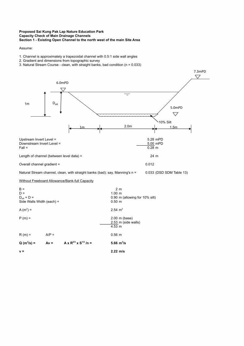
Proposed Sai Kung Pak Lap Nature Education ParkCapacity Check of Main Drainage ChannelsSection 1 - Existing Open Channel to the north west of the main Site Area
Assume:
1. Channel is approximately a trapezoidal channel with 0.5:1 side wall angles2. Gradient and dimensions from topographic survey3. Natural Stream Course - clean, with straight banks, bad condition (n = 0.033)
Upstream Invert Level = 5.28 mPDDownstream Invert Level = 5.00 mPDFall = 0.28 m
Length of channel (between level data) = 24 m
Overall channel gradient = 0.012
Natural Stream channel, clean, with straight banks (bad); say, Manning's n = 0.033 (DSD SDM Table 13)
Without Freeboard Allowance/Bank-full Capacity
B = 2 mD = 1.00 mDsilt = D = 0.90 m (allowing for 10% silt)Side Walls Width (each) = 0.50 m
A (m2) = 2.54 m2
P (m) = 2.00 m (base)2.53 m (side walls)4.53 m
R (m) = A/P = 0.56 m
Q (m3/s) = Av = A x R2/3 x S1/2 /n = 5.66 m3/s
v = 2.22 m/s
2.0m
1m
10% Silt
Dsilt
1.5m 1m
7.3mPD
6.0mPD
5.0mPD

Proposed Sai Kung Pak Lap Nature Education ParkCapacity Check of Main Drainage ChannelsSection 2 - Existing Open Channel to the west of the main Site Area
Assume:
1. Channel is approximately a trapezoidal channel with 0.3:1 side wall angles2. Gradient and dimensions from topographic survey
Capacity of Main Central Weir
Flow, Q = 1.5bh1.5
Q = 1.5 x 1.9 x 0.91.5 = 2.43 m3/s
Capaity of Village Flood Area
Upstream Invert Level = 5.93 mPDDownstream Invert Level = 5.8 mPDFall = 0.13 m
Length of channel (between level data) = 12.5 m
Overall channel gradient, S = 0.010
Pasture, short grass (bad); say, Manning's n = 0.033 (Research data)
A (m2) = 0.5 x 8 x 0.2 0.80 m2
P (m) = (0.22+82)0.5 8.00 m
R (m) = A/P = 0.10 m
Q (m3/s) = Av = A x R2/3 x S1/2 /n = 0.53 m3/s
OVERALL DISCHARGE BEFORE FLOODING = 2.96 m3/s
1.7m
1.05m
Weir 0.35m
0.3m 0.3m
1.9m 0.7m
5.72mPD 5.93mPD 5.93mPD
4.67mPD
8m
0.2m
THE SITE
PAK LAP VILLAGE
5.5mPD

Proposed Sai Kung Pak Lap Nature Education ParkCapacity Check of Main Drainage ChannelsSection 3 - Existing Main Open Channel to the west of the main Site Area
Assume:
1. Channel is approximately a trapezoidal channel with 0.5:1 side wall angles2. Gradient and dimensions from topographic survey3. Natural Stream Course - lower stages, stony, bad condition (n = 0.033)
Upstream Invert Level = 5.54 mPDDownstream Invert Level = 4.24 mPDFall = 1.3 m
Length of channel (between level data) = 200 m
Overall channel gradient = 0.007
Natural Stream channel, lower stages, stony (bad); say, Manning's n = 0.06 (DSD SDM Table 13)
Without Freeboard Allowance
B = 1.7 mD = 0.70 mDsilt = D = 0.63 m (allowing for 10% silt)Side Walls Width (each) = 0.50 m
Top Width = 2.7 m
A (m2) = 1.39 m2
P (m) = 1.70 m (base)1.61 m (side walls)3.31 m
R (m) = A/P = 0.42 m
Q (m3/s) = Av = A x R2/3 x S1/2 /n = 1.04 m3/s
v = 0.75 m/s
1.7m
0.7m
10% Silt
Dsilt
0.5m 0.5m
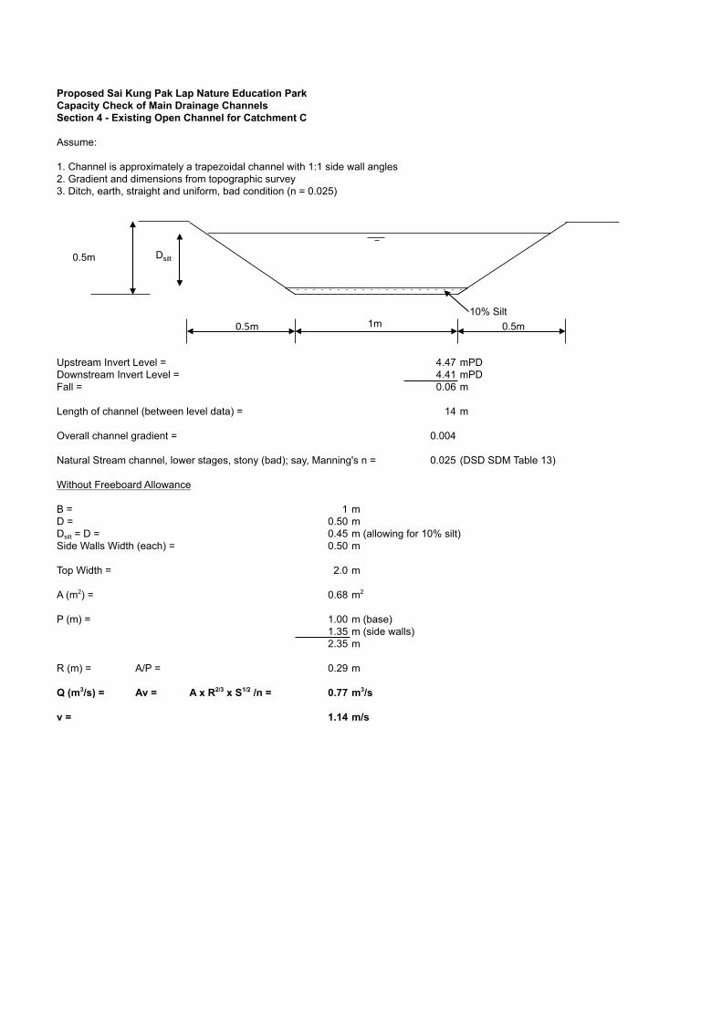
Proposed Sai Kung Pak Lap Nature Education ParkCapacity Check of Main Drainage ChannelsSection 4 - Existing Open Channel for Catchment C
Assume:
1. Channel is approximately a trapezoidal channel with 1:1 side wall angles2. Gradient and dimensions from topographic survey3. Ditch, earth, straight and uniform, bad condition (n = 0.025)
Upstream Invert Level = 4.47 mPDDownstream Invert Level = 4.41 mPDFall = 0.06 m
Length of channel (between level data) = 14 m
Overall channel gradient = 0.004
Natural Stream channel, lower stages, stony (bad); say, Manning's n = 0.025 (DSD SDM Table 13)
Without Freeboard Allowance
B = 1 mD = 0.50 mDsilt = D = 0.45 m (allowing for 10% silt)Side Walls Width (each) = 0.50 m
Top Width = 2.0 m
A (m2) = 0.68 m2
P (m) = 1.00 m (base)1.35 m (side walls)2.35 m
R (m) = A/P = 0.29 m
Q (m3/s) = Av = A x R2/3 x S1/2 /n = 0.77 m3/s
v = 1.14 m/s
1m
0.5m
10% Silt
Dsilt
0.5m 0.5m
Appendix E Figures

Proposed Sai Kung Pak Lap Nature Education Park at Pak Lap, Sai Kung Site Location
Figure 1
colinmoreby
Oval
colinmoreby
Line
colinmoreby
Text Box
SITE LOCATION
colinmoreby
Text Box
Proposed Sai Kung Pak Lap Nature Education Park
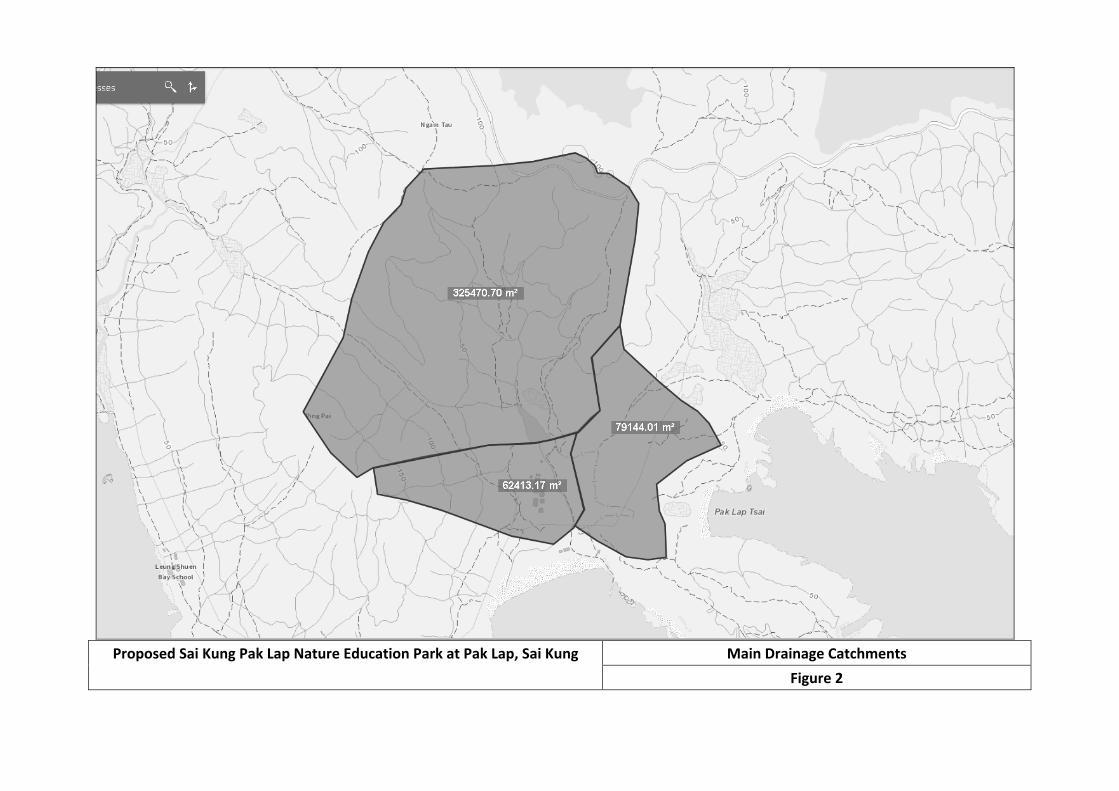
Proposed Sai Kung Pak Lap Nature Education Park at Pak Lap, Sai Kung Main Drainage Catchments
Figure 2
colinmoreby
Polygonal Line
colinmoreby
Polygonal Line
colinmoreby
Polygonal Line
colinmoreby
Polygonal Line
colinmoreby
Rectangle
colinmoreby
Text Box
INDICATIVE SITE AREA
colinmoreby
Text Box
MAIN DRAINAGE ROUTES
colinmoreby
Line
colinmoreby
Text Box
CATCHMENT A
colinmoreby
Text Box
CATCHMENT B
colinmoreby
Text Box
CATCHMENT C
colinmoreby
Text Box
Proposed Sai Kung Pak Lap Nature Education Park
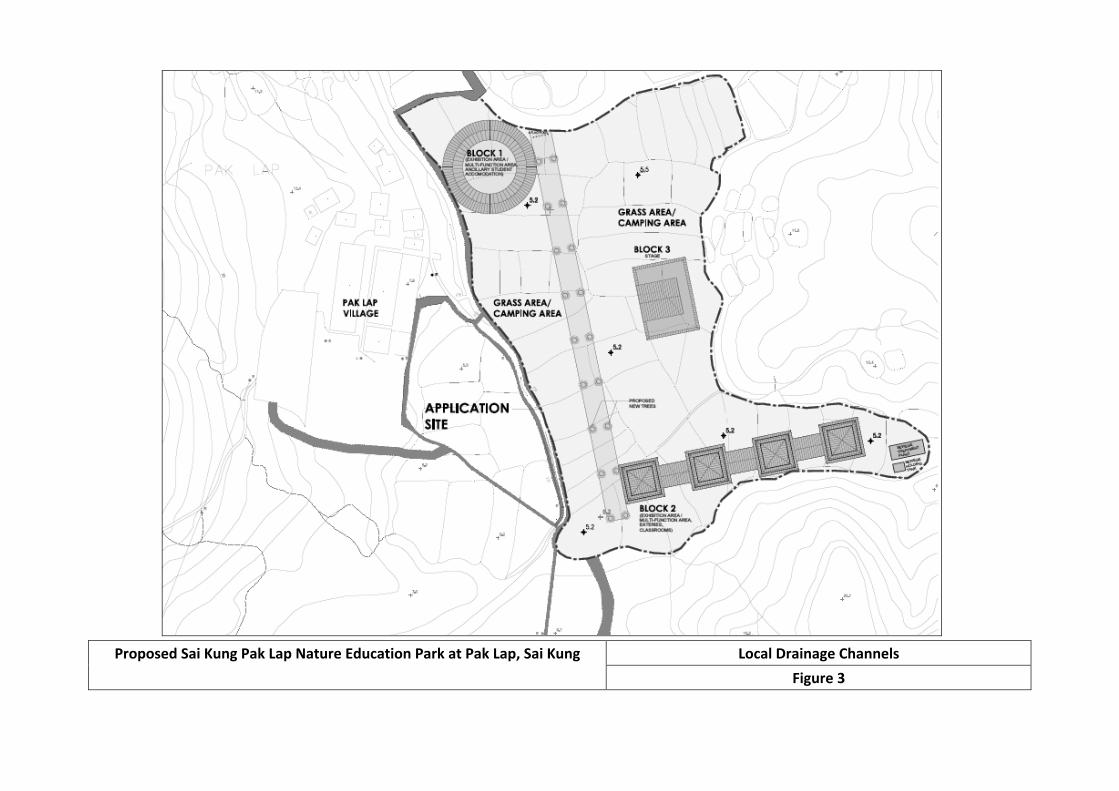
Proposed Sai Kung Pak Lap Nature Education Park at Pak Lap, Sai Kung Local Drainage Channels
Figure 3
colinmoreby
Polygonal Line
colinmoreby
Polygonal Line
colinmoreby
Line
colinmoreby
Line
colinmoreby
Line
colinmoreby
Line
colinmoreby
Line
colinmoreby
Line
colinmoreby
Rectangle
colinmoreby
Text Box
DRAINAGE CHANNEL
colinmoreby
Text Box
APPLICATION SITE
colinmoreby
Line
colinmoreby
Line
colinmoreby
Line
colinmoreby
Line
colinmoreby
Line
colinmoreby
Text Box
CHANNEL SECTION (INDICATIVE) SEE APPENDIX C
colinmoreby
Text Box
1
colinmoreby
Text Box
2
colinmoreby
Text Box
3
colinmoreby
Text Box
4
colinmoreby
Text Box
Proposed Sai Kung Pak Lap Nature Education Park