APPENDIX 1: VISUAL FRAMEWORK & TESTING
88
APPENDIX 1: VISUAL FRAMEWORK & TESTING
Transcript of APPENDIX 1: VISUAL FRAMEWORK & TESTING
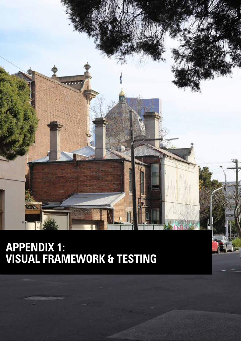
APPENDIX 1: VISUAL FRAMEWORK & TESTING
World Heritage Strategy Plan Review for the REB & Carlton Gardens World Heritage Environs Area| Visual Framework & Testing
2 Hansen Partnership & HLCD Pty Ltd
CONTENTS
1.0 Introduction 3
2.0 Views & Vistas 4
3.0 Views & Vistas Assessment 9
4.0 Built Form Testing 48
5.0 Additional Built Form Testing & Photomontages 68
6.0 Summary of Recommendations 83
Figure 1 - Flagpole Visibility 10
Figure 2 - Lantern Visibility 10
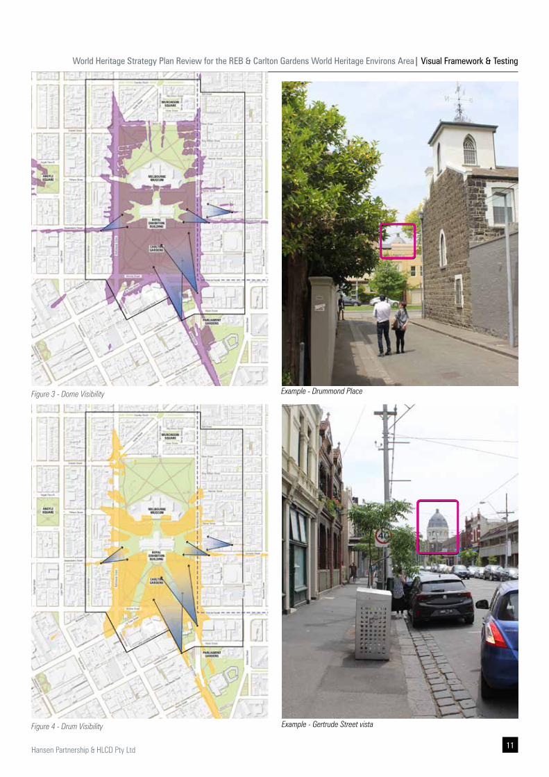
Figure 3 - Dome Visibility 11
Figure 4 - Drum Visibility 11
Figure 5 - Views & Vistas Assessment Framework 13
Figure 6 - Built Form Testing Areas 50
Figure 7 - Camera View Locations 69
Figure 8 - Recommended expansion of DDO6 84
Figure 9 - Recommendations 87
Commonly used throughout this report are abbreviations for key terminology. These are:
▪ 2009 Strategy Plan - 2009 World Heritage Environs Strategy Plan
▪ CoM - City of Melbourne Council
▪ CoY - City of Yarra Council
▪ C1Z - Commercial 1 Zone
▪ DDO - Design & Development Overlay
▪ DELWP - Department of Environment, Land Water & Planning
▪ GRZ - General Residential Zone
▪ Hansen - Hansen Partnership Pty Ltd
▪ HLCD - HLCD Pty Ltd
▪ HO - Heritage Overlay
▪ HV - Heritage Victoria
▪ MUZ - Mixed Use Zone
▪ NRZ - Neighbourhood Residential Zone
▪ Operational Guidelines - Operational Guidelines for the Implementation of the World Heritage Convention (2019)
▪ OUV - Outstanding Universal Value
▪ PUZ - Public Use Zone
▪ REB - Royal Exhibition Building
▪ REB&CG - Royal Exhibition Buildings & Carlton Gardens
▪ REB&CGSC - Royal Exhibition Buildings & Carlton Gardens World Heritage Steering Committee
▪ SoS - Statement of Significance
▪ VHR - Victorian Heritage Register
▪ VCAT - Victoria Civil & Administrative Tribunal
▪ WHEA - World Heritage Environs Area
Abbreviations
World Heritage Strategy Plan Review for the REB & Carlton Gardens World Heritage Environs Area| Visual Framework & Testing
3Hansen Partnership & HLCD Pty Ltd
This report constitutes important background work involving analysis of views and vistas, as well as built form analysis which has informed the suite of recommendations outlined within the draft Strategy Plan. Key sections of this report are also included in the Strategy Plan.
The views, vistas and built form analysis processes have been informed by the following process:
▪ Literature review of relevant views and vistas analysis, documentation and assessment.
▪ Desktop analysis of zone of visual influence.
▪ Identification of aspect and prospect views.
▪ Identification and definition of primary, secondary and supporting views.
▪ Site visits and photographic documentation.
▪ Assessment of view types and identification of sensitive areas for built form testing.
▪ Built form (3D massing) testing of sensitive primary view lines.
1.0 Introduction
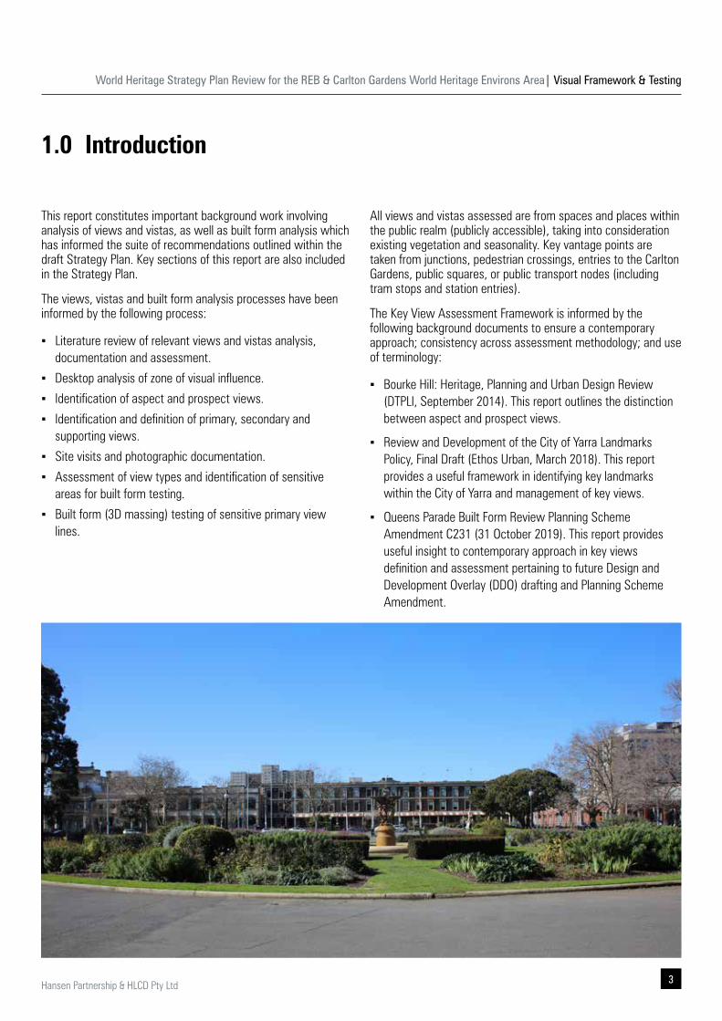
All views and vistas assessed are from spaces and places within the public realm (publicly accessible), taking into consideration existing vegetation and seasonality. Key vantage points are taken from junctions, pedestrian crossings, entries to the Carlton Gardens, public squares, or public transport nodes (including tram stops and station entries).
The Key View Assessment Framework is informed by the following background documents to ensure a contemporary approach; consistency across assessment methodology; and use of terminology:
▪ Bourke Hill: Heritage, Planning and Urban Design Review (DTPLI, September 2014). This report outlines the distinction between aspect and prospect views.
▪ Review and Development of the City of Yarra Landmarks Policy, Final Draft (Ethos Urban, March 2018). This report provides a useful framework in identifying key landmarks within the City of Yarra and management of key views.
▪ Queens Parade Built Form Review Planning Scheme Amendment C231 (31 October 2019). This report provides useful insight to contemporary approach in key views definition and assessment pertaining to future Design and Development Overlay (DDO) drafting and Planning Scheme Amendment.
World Heritage Strategy Plan Review for the REB & Carlton Gardens World Heritage Environs Area| Visual Framework & Testing
4 Hansen Partnership & HLCD Pty Ltd
Views which have been specifically considered and analysed as part of the visual framework and testing include:
▪ Particular emphasis on identifying the location of views and vistas of the REB & Carton Gardens site (building, Dome, gardens) and views out to the surrounding area from within the REB & Carlton Gardens were documented. It comprises type of views and potential management issues to warrant built form testing.
▪ Some of these views (significant and less significant) were acknowledged in the 2009 Strategy Plan, although there was a lack of detailed built form testing undertaken at the time. Regardless of this, some policies where introduced into the Melbourne and Yarra Planning Schemes to address the consideration of selected views.
▪ The Key View Assessment Framework is not intended to replace or overwrite findings from the 2009 Strategy Plan (and recommendation of the Standing Committee). It has been prepared in accordance to contemporary context and to address gaps identified in the WHEA Discussion Paper.
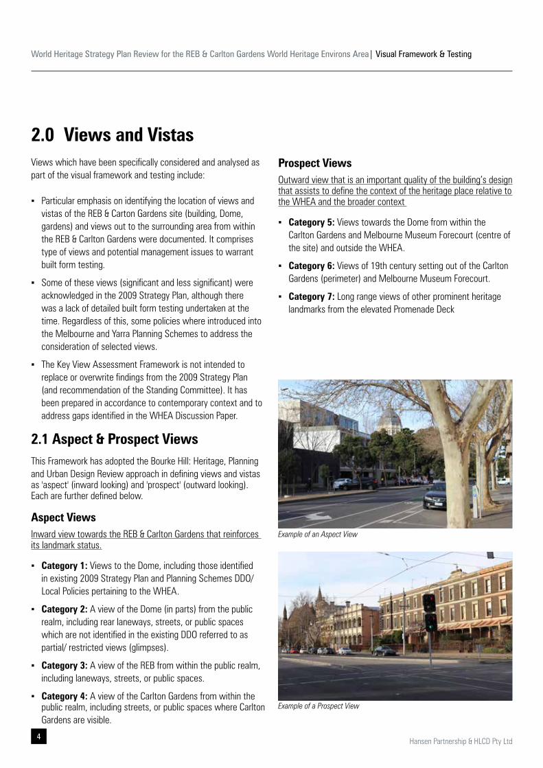
2.1 Aspect & Prospect Views This Framework has adopted the Bourke Hill: Heritage, Planning and Urban Design Review approach in defining views and vistas as 'aspect' (inward looking) and 'prospect' (outward looking). Each are further defined below.
Aspect ViewsInward view towards the REB & Carlton Gardens that reinforces its landmark status.
▪ Category 1: Views to the Dome, including those identified in existing 2009 Strategy Plan and Planning Schemes DDO/ Local Policies pertaining to the WHEA.
▪ Category 2: A view of the Dome (in parts) from the public realm, including rear laneways, streets, or public spaces which are not identified in the existing DDO referred to as partial/ restricted views (glimpses).
▪ Category 3: A view of the REB from within the public realm, including laneways, streets, or public spaces.
▪ Category 4: A view of the Carlton Gardens from within the public realm, including streets, or public spaces where Carlton Gardens are visible.
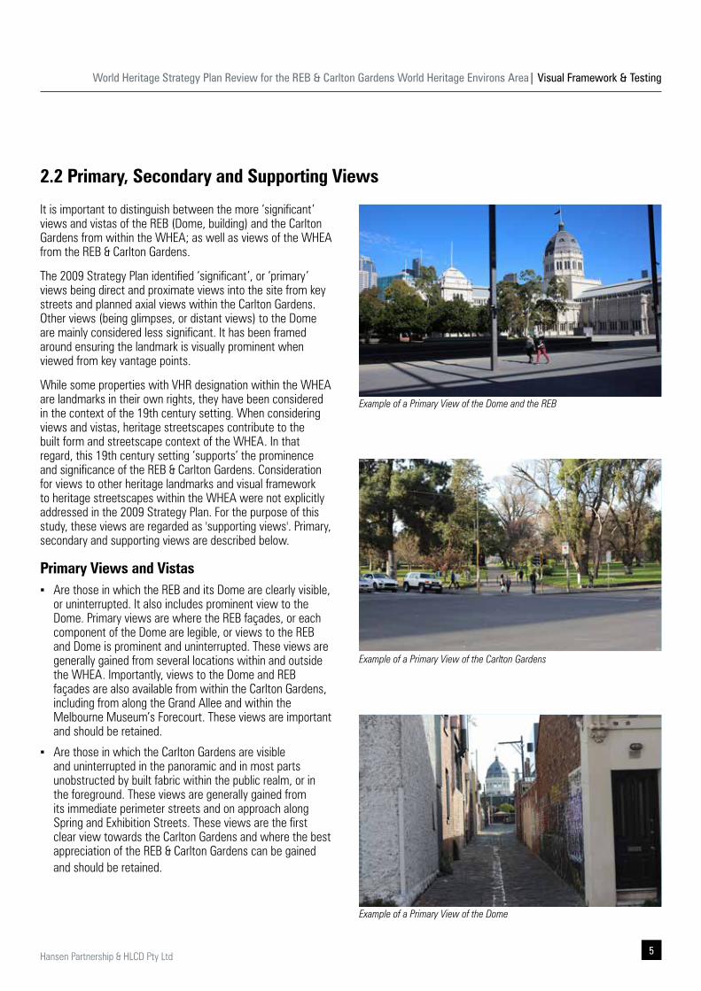
2.0 Views and VistasProspect Views Outward view that is an important quality of the building’s design that assists to define the context of the heritage place relative to the WHEA and the broader context
▪ Category 5: Views towards the Dome from within the Carlton Gardens and Melbourne Museum Forecourt (centre of the site) and outside the WHEA.
▪ Category 6: Views of 19th century setting out of the Carlton Gardens (perimeter) and Melbourne Museum Forecourt.
▪ Category 7: Long range views of other prominent heritage landmarks from the elevated Promenade Deck
Example of an Aspect View
Example of a Prospect View
World Heritage Strategy Plan Review for the REB & Carlton Gardens World Heritage Environs Area| Visual Framework & Testing
5Hansen Partnership & HLCD Pty Ltd
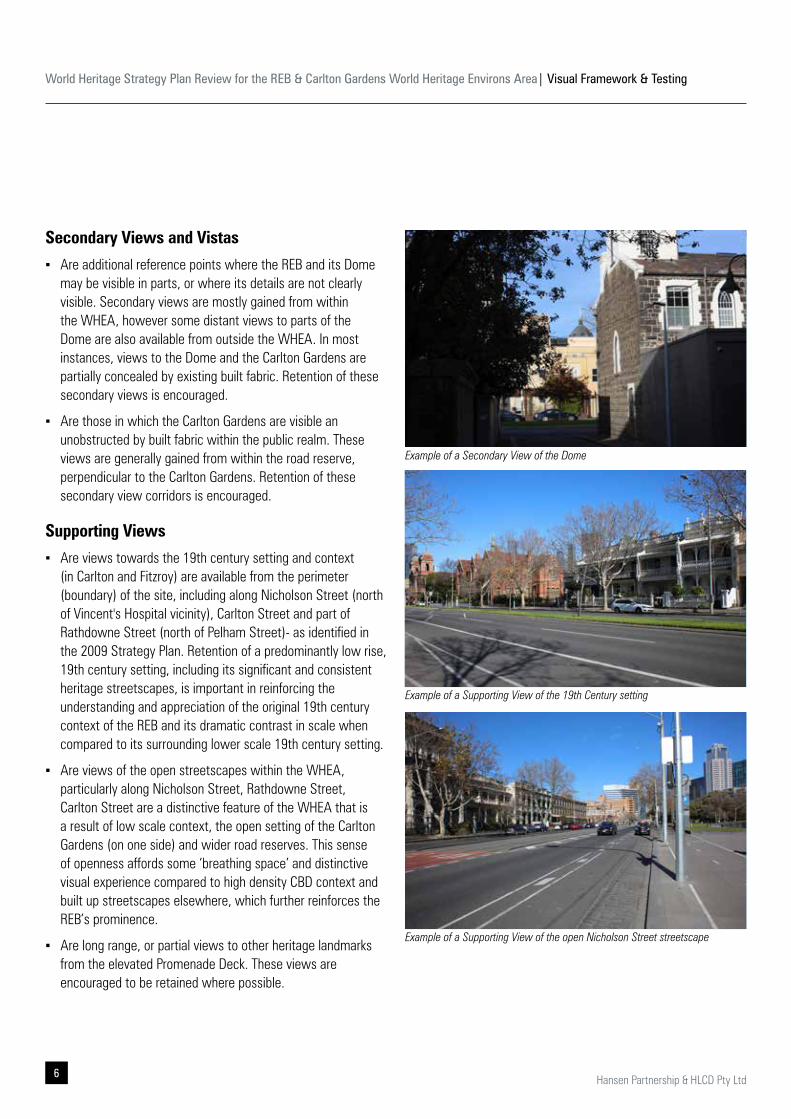
It is important to distinguish between the more ‘significant’ views and vistas of the REB (Dome, building) and the Carlton Gardens from within the WHEA; as well as views of the WHEA from the REB & Carlton Gardens.
The 2009 Strategy Plan identified ‘significant’, or ‘primary’ views being direct and proximate views into the site from key streets and planned axial views within the Carlton Gardens. Other views (being glimpses, or distant views) to the Dome are mainly considered less significant. It has been framed around ensuring the landmark is visually prominent when viewed from key vantage points.
While some properties with VHR designation within the WHEA are landmarks in their own rights, they have been considered in the context of the 19th century setting. When considering views and vistas, heritage streetscapes contribute to the built form and streetscape context of the WHEA. In that regard, this 19th century setting ‘supports’ the prominence and significance of the REB & Carlton Gardens. Consideration for views to other heritage landmarks and visual framework to heritage streetscapes within the WHEA were not explicitly addressed in the 2009 Strategy Plan. For the purpose of this study, these views are regarded as 'supporting views'. Primary, secondary and supporting views are described below.
Primary Views and Vistas ▪ Are those in which the REB and its Dome are clearly visible,
or uninterrupted. It also includes prominent view to the Dome. Primary views are where the REB façades, or each component of the Dome are legible, or views to the REB and Dome is prominent and uninterrupted. These views are generally gained from several locations within and outside the WHEA. Importantly, views to the Dome and REB façades are also available from within the Carlton Gardens, including from along the Grand Allee and within the Melbourne Museum’s Forecourt. These views are important and should be retained.
▪ Are those in which the Carlton Gardens are visible and uninterrupted in the panoramic and in most parts unobstructed by built fabric within the public realm, or in the foreground. These views are generally gained from its immediate perimeter streets and on approach along Spring and Exhibition Streets. These views are the first clear view towards the Carlton Gardens and where the best appreciation of the REB & Carlton Gardens can be gained and should be retained.
2.2 Primary, Secondary and Supporting Views
Example of a Primary View of the Dome
Example of a Primary View of the Dome and the REB
Example of a Primary View of the Carlton Gardens
World Heritage Strategy Plan Review for the REB & Carlton Gardens World Heritage Environs Area| Visual Framework & Testing
6 Hansen Partnership & HLCD Pty Ltd
Secondary Views and Vistas
▪ Are additional reference points where the REB and its Dome may be visible in parts, or where its details are not clearly visible. Secondary views are mostly gained from within the WHEA, however some distant views to parts of the Dome are also available from outside the WHEA. In most instances, views to the Dome and the Carlton Gardens are partially concealed by existing built fabric. Retention of these secondary views is encouraged.
▪ Are those in which the Carlton Gardens are visible an unobstructed by built fabric within the public realm. These views are generally gained from within the road reserve, perpendicular to the Carlton Gardens. Retention of these secondary view corridors is encouraged.
Supporting Views
▪ Are views towards the 19th century setting and context (in Carlton and Fitzroy) are available from the perimeter (boundary) of the site, including along Nicholson Street (north of Vincent's Hospital vicinity), Carlton Street and part of Rathdowne Street (north of Pelham Street)- as identified in the 2009 Strategy Plan. Retention of a predominantly low rise, 19th century setting, including its significant and consistent heritage streetscapes, is important in reinforcing the understanding and appreciation of the original 19th century context of the REB and its dramatic contrast in scale when compared to its surrounding lower scale 19th century setting.
▪ Are views of the open streetscapes within the WHEA, particularly along Nicholson Street, Rathdowne Street, Carlton Street are a distinctive feature of the WHEA that is a result of low scale context, the open setting of the Carlton Gardens (on one side) and wider road reserves. This sense of openness affords some ‘breathing space’ and distinctive visual experience compared to high density CBD context and built up streetscapes elsewhere, which further reinforces the REB’s prominence.
▪ Are long range, or partial views to other heritage landmarks from the elevated Promenade Deck. These views are encouraged to be retained where possible.
Example of a Secondary View of the Dome
Example of a Supporting View of the 19th Century setting
Example of a Supporting View of the open Nicholson Street streetscape
World Heritage Strategy Plan Review for the REB & Carlton Gardens World Heritage Environs Area| Visual Framework & Testing
7Hansen Partnership & HLCD Pty Ltd
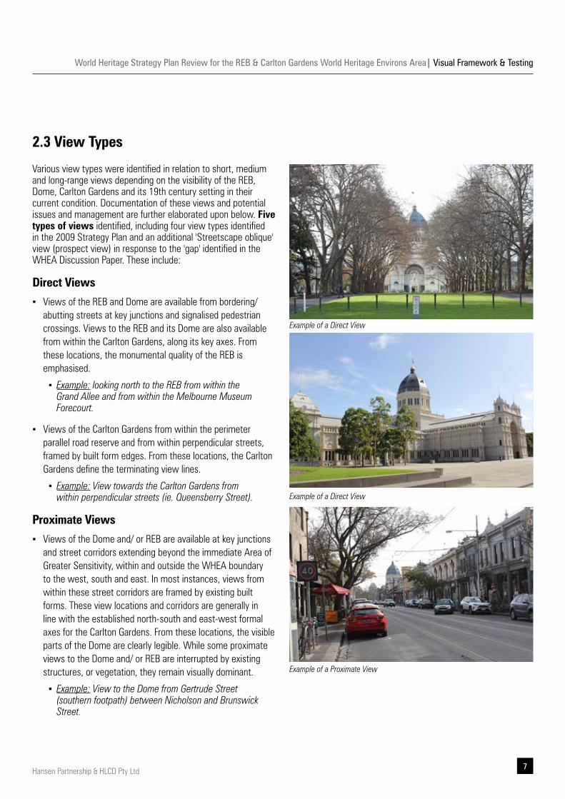
Various view types were identified in relation to short, medium and long-range views depending on the visibility of the REB, Dome, Carlton Gardens and its 19th century setting in their current condition. Documentation of these views and potential issues and management are further elaborated upon below. Five types of views identified, including four view types identified in the 2009 Strategy Plan and an additional 'Streetscape oblique' view (prospect view) in response to the 'gap' identified in the WHEA Discussion Paper. These include:
Direct Views
▪ Views of the REB and Dome are available from bordering/ abutting streets at key junctions and signalised pedestrian crossings. Views to the REB and its Dome are also available from within the Carlton Gardens, along its key axes. From these locations, the monumental quality of the REB is emphasised.
▪ Example: looking north to the REB from within the Grand Allee and from within the Melbourne Museum Forecourt.
▪ Views of the Carlton Gardens from within the perimeter parallel road reserve and from within perpendicular streets, framed by built form edges. From these locations, the Carlton Gardens define the terminating view lines.
▪ Example: View towards the Carlton Gardens from within perpendicular streets (ie. Queensberry Street).
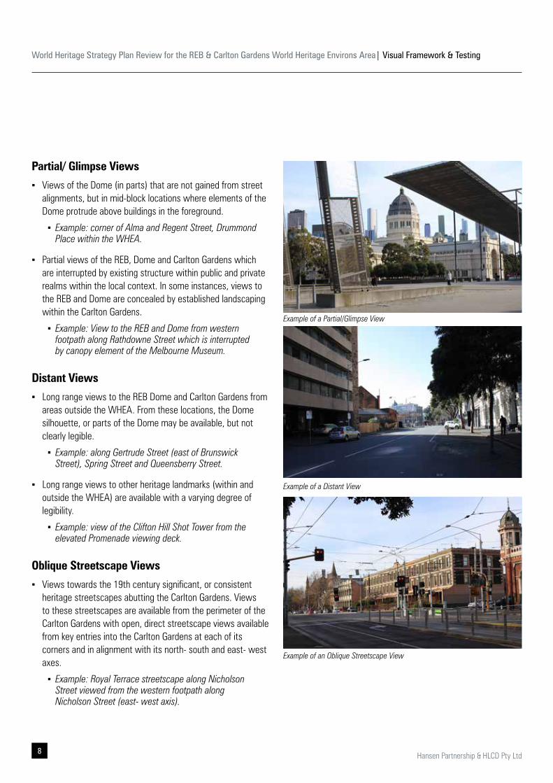
Proximate Views
▪ Views of the Dome and/ or REB are available at key junctions and street corridors extending beyond the immediate Area of Greater Sensitivity, within and outside the WHEA boundary to the west, south and east. In most instances, views from within these street corridors are framed by existing built forms. These view locations and corridors are generally in line with the established north-south and east-west formal axes for the Carlton Gardens. From these locations, the visible parts of the Dome are clearly legible. While some proximate views to the Dome and/ or REB are interrupted by existing structures, or vegetation, they remain visually dominant.
▪ Example: View to the Dome from Gertrude Street (southern footpath) between Nicholson and Brunswick Street.
2.3 View Types
Example of a Direct View
Example of a Direct View
Example of a Proximate View
World Heritage Strategy Plan Review for the REB & Carlton Gardens World Heritage Environs Area| Visual Framework & Testing
8 Hansen Partnership & HLCD Pty Ltd
Partial/ Glimpse Views
▪ Views of the Dome (in parts) that are not gained from street alignments, but in mid-block locations where elements of the Dome protrude above buildings in the foreground.
▪ Example: corner of Alma and Regent Street, Drummond Place within the WHEA.
▪ Partial views of the REB, Dome and Carlton Gardens which are interrupted by existing structure within public and private realms within the local context. In some instances, views to the REB and Dome are concealed by established landscaping within the Carlton Gardens.
▪ Example: View to the REB and Dome from western footpath along Rathdowne Street which is interrupted by canopy element of the Melbourne Museum.
Distant Views
▪ Long range views to the REB Dome and Carlton Gardens from areas outside the WHEA. From these locations, the Dome silhouette, or parts of the Dome may be available, but not clearly legible.
▪ Example: along Gertrude Street (east of Brunswick Street), Spring Street and Queensberry Street.
▪ Long range views to other heritage landmarks (within and outside the WHEA) are available with a varying degree of legibility.
▪ Example: view of the Clifton Hill Shot Tower from the elevated Promenade viewing deck.
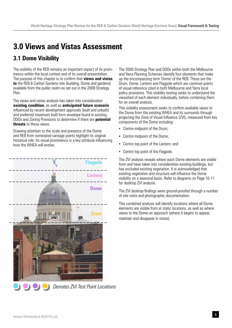
Oblique Streetscape Views
▪ Views towards the 19th century significant, or consistent heritage streetscapes abutting the Carlton Gardens. Views to these streetscapes are available from the perimeter of the Carlton Gardens with open, direct streetscape views available from key entries into the Carlton Gardens at each of its corners and in alignment with its north- south and east- west axes.
▪ Example: Royal Terrace streetscape along Nicholson Street viewed from the western footpath along Nicholson Street (east- west axis).
Example of a Partial/Glimpse View
Example of a Distant View
Example of an Oblique Streetscape View
World Heritage Strategy Plan Review for the REB & Carlton Gardens World Heritage Environs Area| Visual Framework & Testing
9Hansen Partnership & HLCD Pty Ltd
3.0 Views and Vistas Assessment3.1 Dome Visibility
The visibility of the REB remains an important aspect of its prom-inence within the local context and of its overall presentation. The purpose of this chapter is to confirm that views and vistas to the REB & Carlton Gardens site (building, Dome and gardens) available from the public realm as set out in the 2009 Strategy Plan.
The views and vistas analysis has taken into consideration existing condition, as well as anticipated future scenario influenced by recent development approvals (built and unbuilt) and preferred maximum built form envelope found in existing DDOs and Zoning Provisions to determine if there are potential threats to these views.
Drawing attention to the scale and presence of the Dome and REB from nominated vantage points highlight its original historical role. Its visual prominence is a key attribute influencing how the WHEA will evolve.
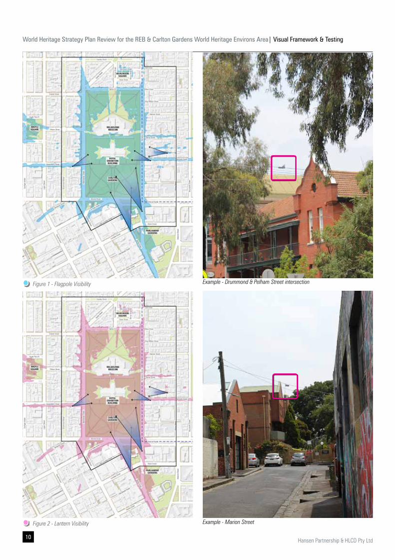
The 2009 Strategy Plan and DDOs within both the Melbourne and Yarra Planning Schemes identify four elements that make up the encompassing term 'Dome' of the REB. These are the Drum, Dome, Lantern and Flagpole which are common points of visual reference cited in both Melbourne and Yarra local policy provisions. This visibility testing seeks to understand the viewshed of each element individually, before combining them for an overall analysis. This visibility assessment seeks to confirm available views to the Dome from the existing WHEA and its surrounds through projecting the Zone of Visual Influence (ZVI), measured from key components of the Dome including:
▪ Centre midpoint of the Drum;
▪ Centre midpoint of the Dome;
▪ Centre top point of the Lantern; and
▪ Centre top point of the Flagpole.
The ZVI analysis reveals where each Dome elements are visible from and have taken into consideration existing buildings, but has excluded existing vegetation. It is acknowledged that existing vegetation and structure will influence the Dome visibility on a seasonal basis. Refer to diagrams on Page 10-11 for desktop ZVI analysis.
The ZVI desktop findings were ground-proofed through a number of site visits and photographic documentation.
This combined analysis will identify locations where all Dome elements are visible from at static locations, as well as where views to the Dome on approach (where it begins to appear, maintain and disappear in vistas).
Denotes ZVI Test Point Locations
Drum
Dome
Lantern
Flagpole
World Heritage Strategy Plan Review for the REB & Carlton Gardens World Heritage Environs Area| Visual Framework & Testing
10 Hansen Partnership & HLCD Pty Ltd
Example - Drummond & Pelham Street intersection
Example - Marion Street
Figure 1 - Flagpole Visibility
Figure 2 - Lantern Visibility
World Heritage Strategy Plan Review for the REB & Carlton Gardens World Heritage Environs Area| Visual Framework & Testing
11Hansen Partnership & HLCD Pty Ltd
Example - Drummond Place
Example - Gertrude Street vista
Figure 3 - Dome Visibility
Figure 4 - Drum Visibility
World Heritage Strategy Plan Review for the REB & Carlton Gardens World Heritage Environs Area| Visual Framework & Testing
12 Hansen Partnership & HLCD Pty Ltd
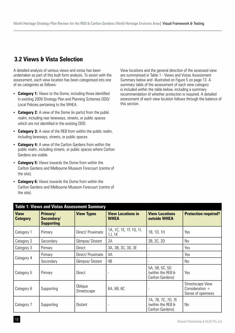
Table 1: Views and Vistas Assessment SummaryView Category
Primary/Secondary/Supporting
View Types View Locations in WHEA
View Locations outside WHEA
Protection required?
Category 1 Primary Direct/ Proximate 1A, 1C, 1E, 1F, 1G, 1I, 1J, 1K 1B, 1D, 1H Yes
Category 2 Secondary Glimpse/ Distant 2A 2B, 2C, 2D No
Category 3 Primary Direct 3A, 3B, 3C, 3D, 3E - Yes
Category 4Primary Direct/ Proximate 4A - Yes
Secondary Glimpse/ Distant 4B - No
Category 5 Primary Direct -5A, 5B, 5C, 5D (within the REB & Carlton Gardens)
Yes
Category 6 Supporting Oblique Streetscape 6A, 6B, 6C -
Streetscape View Consideration + Sense of openness
Category 7 Supporting Distant -7A, 7B, 7C, 7D, 7E (within the REB & Carlton Gardens)
No
A detailed analysis of various views and vistas has been undertaken as part of this built form analysis. To assist with the assessment, each view location has been categorised into one of six categories as follows:
▪ Category 1: Views to the Dome, including those identified in existing 2009 Strategy Plan and Planning Schemes DDO/ Local Policies pertaining to the WHEA.
▪ Category 2: A view of the Dome (in parts) from the public realm, including rear laneways, streets, or public spaces which are not identified in the existing DDO.
▪ Category 3: A view of the REB from within the public realm, including laneways, streets, or public spaces
▪ Category 4: A view of the Carlton Gardens from within the public realm, including streets, or public spaces where Carlton Gardens are visible.
▪ Category 5: Views towards the Dome from within the Carlton Gardens and Melbourne Museum Forecourt (centre of the site).
▪ Category 6: Views towards the Dome from within the Carlton Gardens and Melbourne Museum Forecourt (centre of the site).
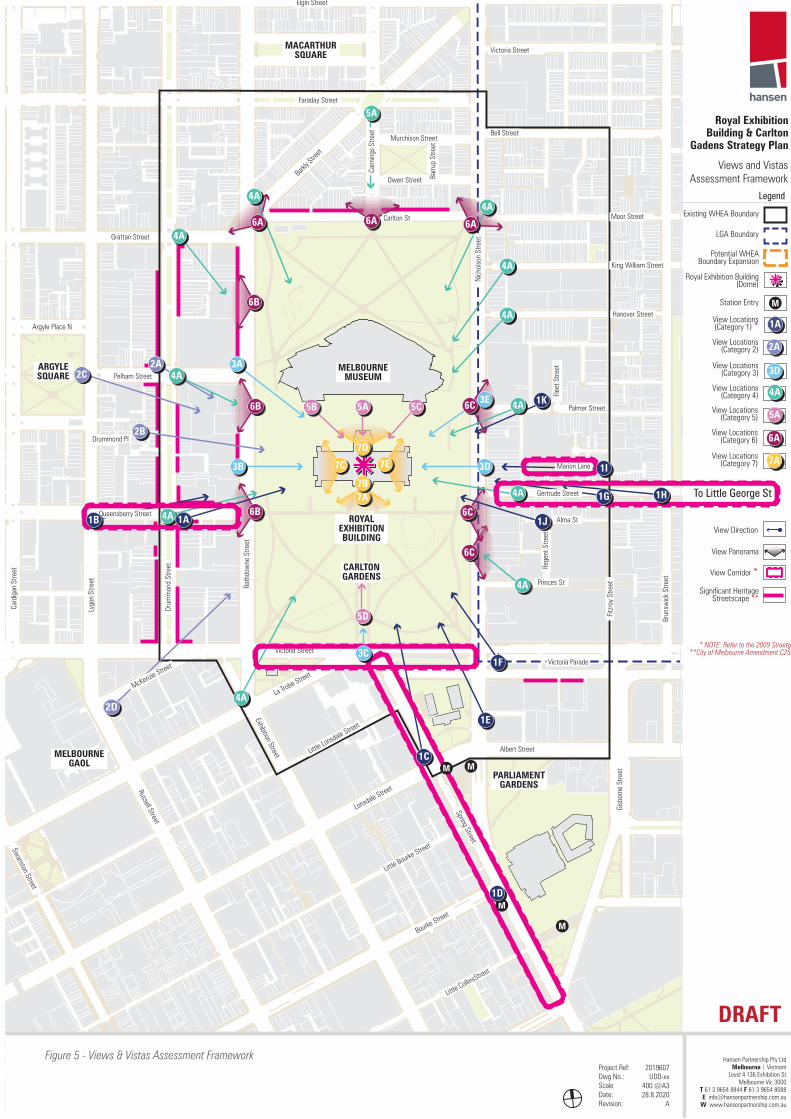
View locations and the general direction of the assessed view are summarised in Table 1 - Views and Vistas Assessment Summary below and illustrated on Figure 5 on page 13. A summary table of the assessment of each view category is included within the table below, including a summary recommendation of whether protection is required. A detailed assessment of each view location follows through the balance of this section.
3.2 Views & Vista Selection
World Heritage Strategy Plan Review for the REB & Carlton Gardens World Heritage Environs Area| Visual Framework & Testing
13Hansen Partnership & HLCD Pty Ltd
Victoria Street
La Trobe Street
Little Lonsdale Street
Spring Street
Exhibition Street
Victoria Parade
Albert Street
Rath
dow
ne S
treet
Drum
mon
d St
reet
Grattan Street
Carlton St
Faraday Street
Elgin Street
Murchison StreetBell Street
Victoria Street
Moor Street
King William Street
Hanover Street
Palmer Street
Gertrude Street
Owen StreetBark
ly Stre
et
Pelham Street
Queensberry Street
Cann
ings
Stre
et
Barru
p St
reet
Nich
olso
n St
reet
Rege
nt S
treet
Lonsdale Street
Little Bourke Street
Bourke Street
Little CollinsStreet
Russell Street
Lygo
n St
reet
Brun
swic
k St
reet
Fitzr
oy S
treet
Card
igan
Stre
et
Gisb
orne
Stre
et
Swanston Street
McKenzie Street
Argyle Place N
Marion Lane
Alma St
Drummond Pl
Princes St
Fleet
Stre
et
MACARTHURSQUARE
CARLTONGARDENS
MELBOURNE GAOL
PARLIAMENTGARDENS
MELBOURNEMUSEUM
ROYAL EXHIBITION BUILDING
ARGYLE SQUARE
Views and Vistas Assessment Framework
DRAFT
Project Ref: Dwg No.:ScaleDate:Revision:
2019607UDD-xx
400 @A328.8.2020
A
Royal Exhibition Building & Carlton
Gadens Strategy Plan
Hansen Partnership Pty LtdMelbourne | Vietnam
Level 4 136 Exhibition StMelbourne Vic 3000
T 61 3 9654 8844 F 61 3 9654 8088 E [email protected]
W www.hansenpartnership.com.au
Existing WHEA Boundary
Legend
LGA Boundary
Royal Exhibition Building (Dome)
Station Entry
View Direction
View Locations (Category 1) *View Locations
(Category 2)
1A1A
View Locations (Category 3)
View Locations (Category 4)
View Locations (Category 5)
View Locations (Category 6)
View Locations (Category 7)
2A2A
3D3D
4A4A
5A5A
7A7A
6A6A
7A7A
M
View Panorama
View Corridor *
* NOTE: Refer to the 2009 Straetgy**City of Melbourne Amendment C258
Significant Heritage Streetscape **
Potential WHEA Boundary Expansion
To Little George St
M M
M
M
7A7A7B7B
7C7C 7E7E7D7D
6A6A6A6A 6A6A
6C6C
6C6C
6C6C
6B6B
6B6B
6B6B
5A5A
5D5D
5B5B 5C5C
5A5A
4A4A
4A4A
4A4A
4A4A
4A4A
4A4A
4A4A
4A4A
4A4A4A4A
4A4A
3C3C
3D3D3B3B
3E3E
3A3A
2B2B
2A2A2C2C
2D2D
1A1A
1C1C
1D1D
1G1G
1I1I
1H1H
1F1F
1B1B 1J1J
1K1K
1E1E
Figure 5 - Views & Vistas Assessment Framework
World Heritage Strategy Plan Review for the REB & Carlton Gardens World Heritage Environs Area| Visual Framework & Testing
14 Hansen Partnership & HLCD Pty Ltd
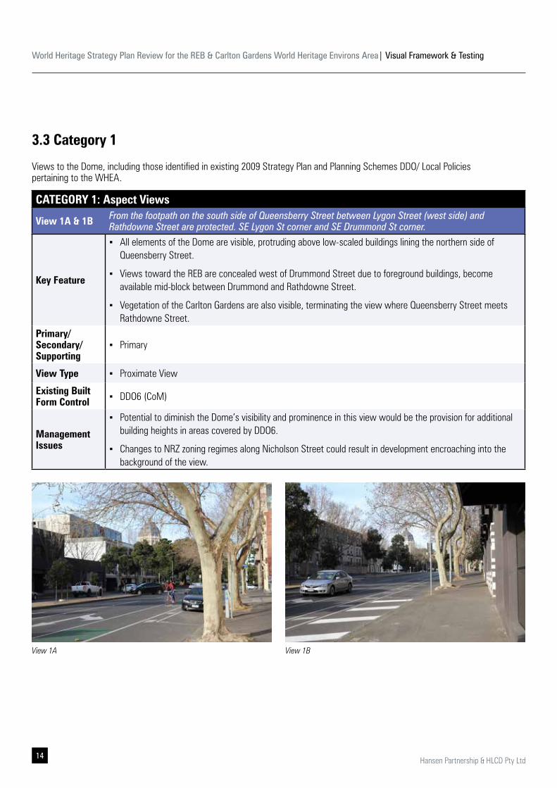
3.3 Category 1
CATEGORY 1: Aspect Views
View 1A & 1B From the footpath on the south side of Queensberry Street between Lygon Street (west side) and Rathdowne Street are protected. SE Lygon St corner and SE Drummond St corner.
Key Feature
▪ All elements of the Dome are visible, protruding above low-scaled buildings lining the northern side of Queensberry Street.
▪ Views toward the REB are concealed west of Drummond Street due to foreground buildings, become available mid-block between Drummond and Rathdowne Street.
▪ Vegetation of the Carlton Gardens are also visible, terminating the view where Queensberry Street meets Rathdowne Street.
Primary/ Secondary/ Supporting
▪ Primary
View Type ▪ Proximate View
Existing Built Form Control ▪ DDO6 (CoM)
Management Issues
▪ Potential to diminish the Dome’s visibility and prominence in this view would be the provision for additional building heights in areas covered by DDO6.
▪ Changes to NRZ zoning regimes along Nicholson Street could result in development encroaching into the background of the view.
View 1BView 1A
Views to the Dome, including those identified in existing 2009 Strategy Plan and Planning Schemes DDO/ Local Policies pertaining to the WHEA.
World Heritage Strategy Plan Review for the REB & Carlton Gardens World Heritage Environs Area| Visual Framework & Testing
15Hansen Partnership & HLCD Pty Ltd
CATEGORY 1: Aspect Views
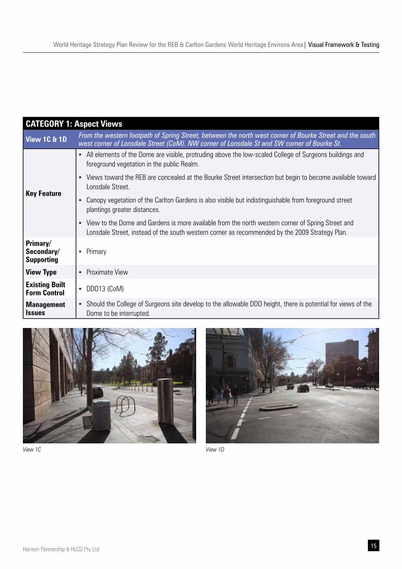
View 1C & 1D From the western footpath of Spring Street, between the north west corner of Bourke Street and the south west corner of Lonsdale Street (CoM). NW corner of Lonsdale St and SW corner of Bourke St.
Key Feature
▪ All elements of the Dome are visible, protruding above the low-scaled College of Surgeons buildings and foreground vegetation in the public Realm.
▪ Views toward the REB are concealed at the Bourke Street intersection but begin to become available toward Lonsdale Street.
▪ Canopy vegetation of the Carlton Gardens is also visible but indistinguishable from foreground street plantings greater distances.
▪ View to the Dome and Gardens is more available from the north western corner of Spring Street and Lonsdale Street, instead of the south western corner as recommended by the 2009 Strategy Plan.
Primary/ Secondary/ Supporting
▪ Primary
View Type ▪ Proximate View
Existing Built Form Control ▪ DDO13 (CoM)
Management Issues
▪ Should the College of Surgeons site develop to the allowable DDO height, there is potential for views of the Dome to be interrupted.
View 1DView 1C
World Heritage Strategy Plan Review for the REB & Carlton Gardens World Heritage Environs Area| Visual Framework & Testing
16 Hansen Partnership & HLCD Pty Ltd
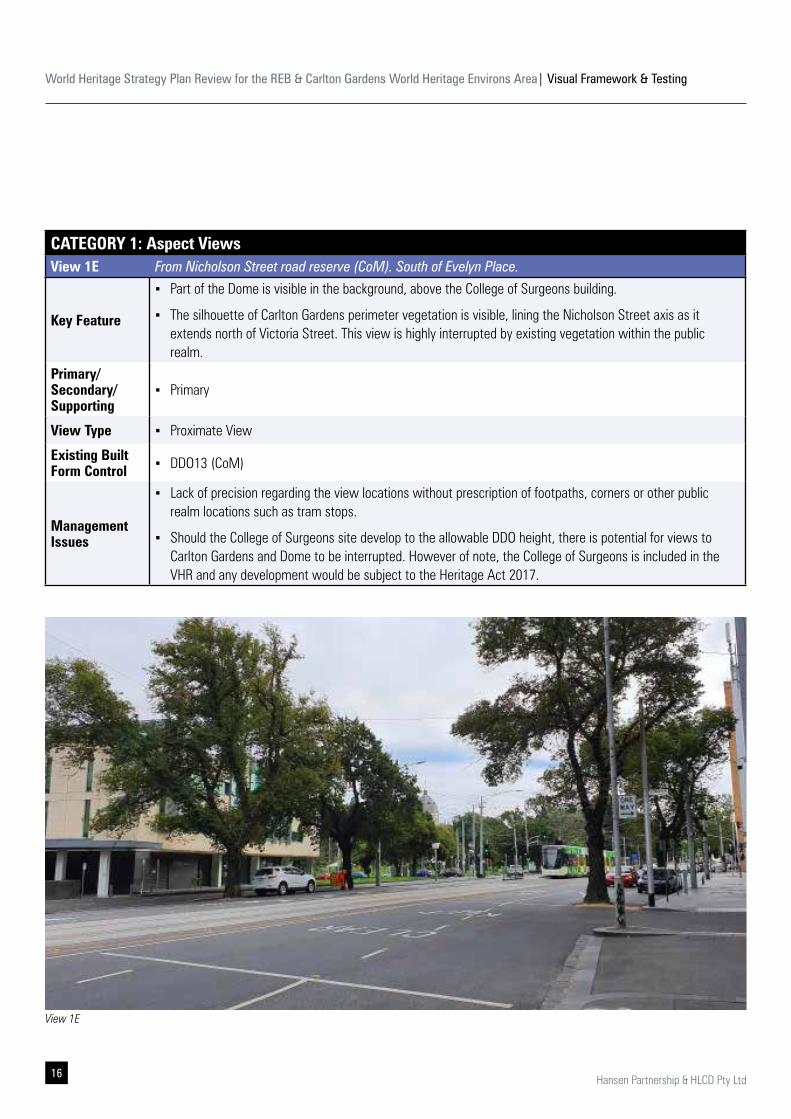
CATEGORY 1: Aspect ViewsView 1E From Nicholson Street road reserve (CoM). South of Evelyn Place.
Key Feature
▪ Part of the Dome is visible in the background, above the College of Surgeons building.
▪ The silhouette of Carlton Gardens perimeter vegetation is visible, lining the Nicholson Street axis as it extends north of Victoria Street. This view is highly interrupted by existing vegetation within the public realm.
Primary/ Secondary/ Supporting
▪ Primary
View Type ▪ Proximate View
Existing Built Form Control ▪ DDO13 (CoM)
Management Issues
▪ Lack of precision regarding the view locations without prescription of footpaths, corners or other public realm locations such as tram stops.
▪ Should the College of Surgeons site develop to the allowable DDO height, there is potential for views to Carlton Gardens and Dome to be interrupted. However of note, the College of Surgeons is included in the VHR and any development would be subject to the Heritage Act 2017.
View 1E
World Heritage Strategy Plan Review for the REB & Carlton Gardens World Heritage Environs Area| Visual Framework & Testing
17Hansen Partnership & HLCD Pty Ltd
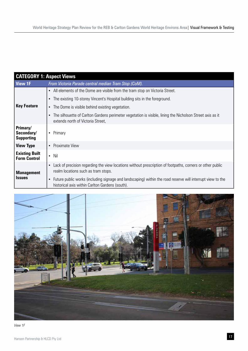
CATEGORY 1: Aspect ViewsView 1F From Victoria Parade central median Tram Stop (CoM).
Key Feature
▪ All elements of the Dome are visible from the tram stop on Victoria Street.
▪ The existing 10-storey Vincent's Hospital building sits in the foreground.
▪ The Dome is visible behind existing vegetation.
▪ The silhouette of Carlton Gardens perimeter vegetation is visible, lining the Nicholson Street axis as it extends north of Victoria Street,
Primary/ Secondary/ Supporting
▪ Primary
View Type ▪ Proximate View
Existing Built Form Control ▪ Nil
Management Issues
▪ Lack of precision regarding the view locations without prescription of footpaths, corners or other public realm locations such as tram stops.
▪ Future public works (including signage and landscaping) within the road reserve will interrupt view to the historical axis within Carlton Gardens (south).
View 1F
World Heritage Strategy Plan Review for the REB & Carlton Gardens World Heritage Environs Area| Visual Framework & Testing
18 Hansen Partnership & HLCD Pty Ltd
CATEGORY 1: Aspect Views
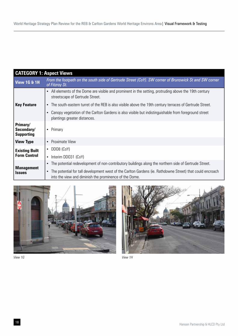
View 1G & 1H From the footpath on the south side of Gertrude Street (CoY). SW corner of Brunswick St and SW corner of Fitzroy St.
Key Feature
▪ All elements of the Dome are visible and prominent in the setting, protruding above the 19th century streetscape of Gertrude Street.
▪ The south-eastern turret of the REB is also visible above the 19th century terraces of Gertrude Street.
▪ Canopy vegetation of the Carlton Gardens is also visible but indistinguishable from foreground street plantings greater distances.
Primary/ Secondary/ Supporting
▪ Primary
View Type ▪ Proximate View
Existing Built Form Control
▪ DDO8 (CoY)
▪ Interim DDO31 (CoY)
Management Issues
▪ The potential redevelopment of non-contributory buildings along the northern side of Gertrude Street.
▪ The potential for tall development west of the Carlton Gardens (ie. Rathdowne Street) that could encroach into the view and diminish the prominence of the Dome.
View 1G View 1H
World Heritage Strategy Plan Review for the REB & Carlton Gardens World Heritage Environs Area| Visual Framework & Testing
19Hansen Partnership & HLCD Pty Ltd
View 1I
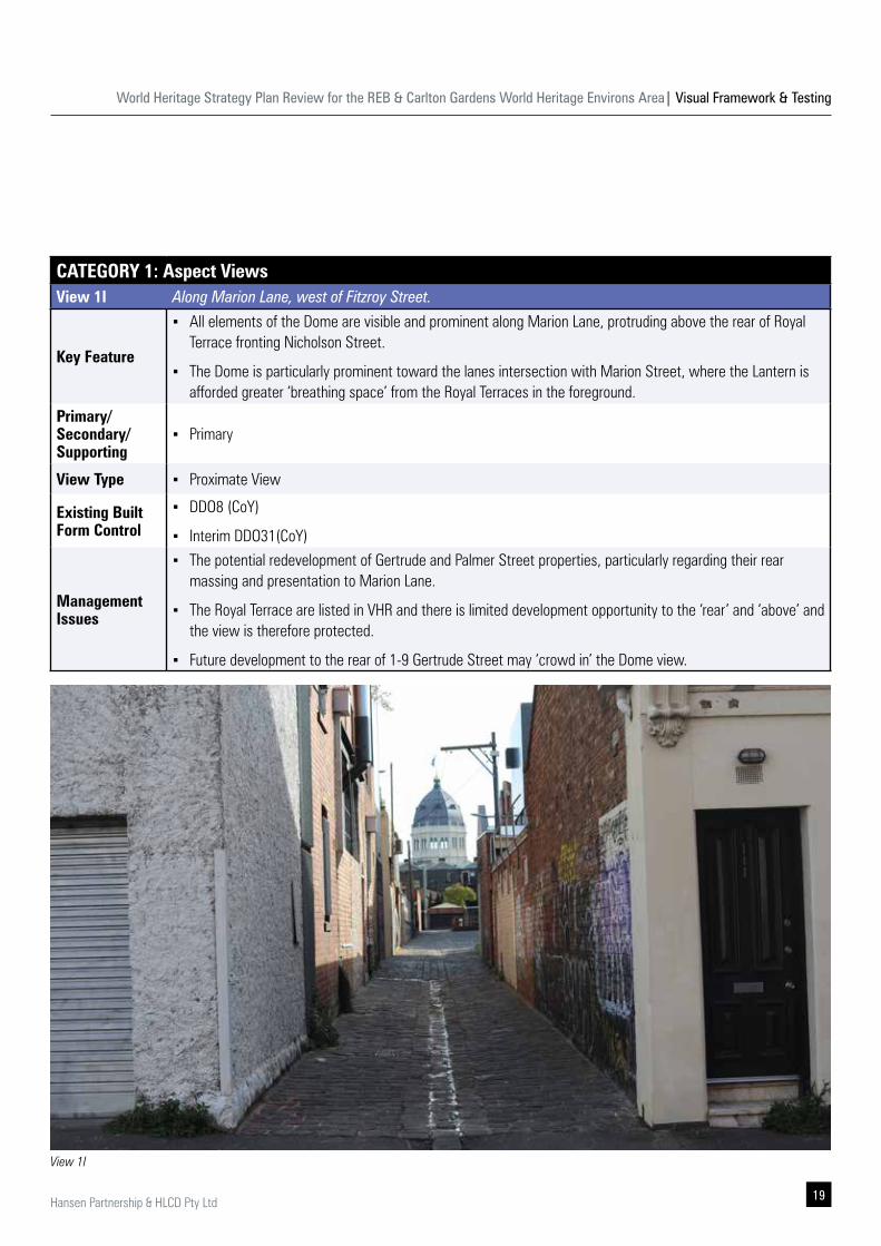
CATEGORY 1: Aspect ViewsView 1I Along Marion Lane, west of Fitzroy Street.
Key Feature
▪ All elements of the Dome are visible and prominent along Marion Lane, protruding above the rear of Royal Terrace fronting Nicholson Street.
▪ The Dome is particularly prominent toward the lanes intersection with Marion Street, where the Lantern is afforded greater ‘breathing space’ from the Royal Terraces in the foreground.
Primary/ Secondary/ Supporting
▪ Primary
View Type ▪ Proximate View
Existing Built Form Control
▪ DDO8 (CoY)
▪ Interim DDO31(CoY)
Management Issues
▪ The potential redevelopment of Gertrude and Palmer Street properties, particularly regarding their rear massing and presentation to Marion Lane.
▪ The Royal Terrace are listed in VHR and there is limited development opportunity to the ‘rear’ and ‘above’ and the view is therefore protected.
▪ Future development to the rear of 1-9 Gertrude Street may ‘crowd in’ the Dome view.
World Heritage Strategy Plan Review for the REB & Carlton Gardens World Heritage Environs Area| Visual Framework & Testing
20 Hansen Partnership & HLCD Pty Ltd
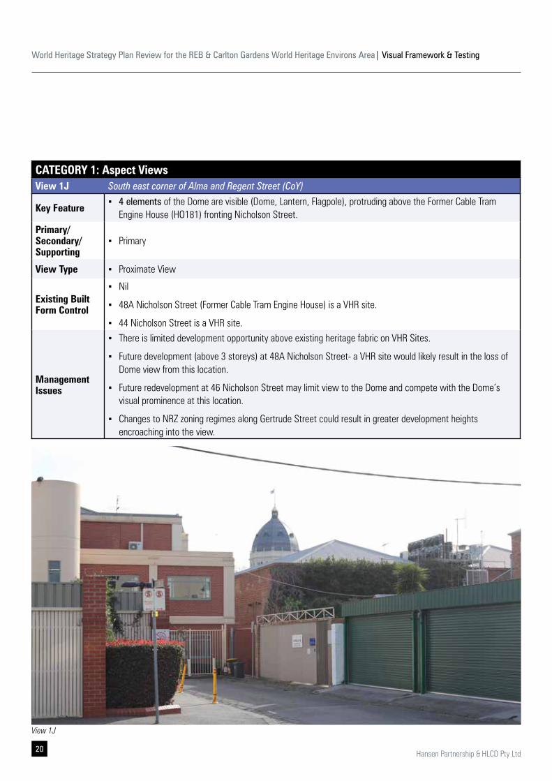
CATEGORY 1: Aspect ViewsView 1J South east corner of Alma and Regent Street (CoY)
Key Feature ▪ 4 elements of the Dome are visible (Dome, Lantern, Flagpole), protruding above the Former Cable Tram
Engine House (HO181) fronting Nicholson Street.Primary/ Secondary/ Supporting
▪ Primary
View Type ▪ Proximate View
Existing Built Form Control
▪ Nil
▪ 48A Nicholson Street (Former Cable Tram Engine House) is a VHR site.
▪ 44 Nicholson Street is a VHR site.
Management Issues
▪ There is limited development opportunity above existing heritage fabric on VHR Sites.
▪ Future development (above 3 storeys) at 48A Nicholson Street- a VHR site would likely result in the loss of Dome view from this location.
▪ Future redevelopment at 46 Nicholson Street may limit view to the Dome and compete with the Dome’s visual prominence at this location.
▪ Changes to NRZ zoning regimes along Gertrude Street could result in greater development heights encroaching into the view.
View 1J
World Heritage Strategy Plan Review for the REB & Carlton Gardens World Heritage Environs Area| Visual Framework & Testing
21Hansen Partnership & HLCD Pty Ltd
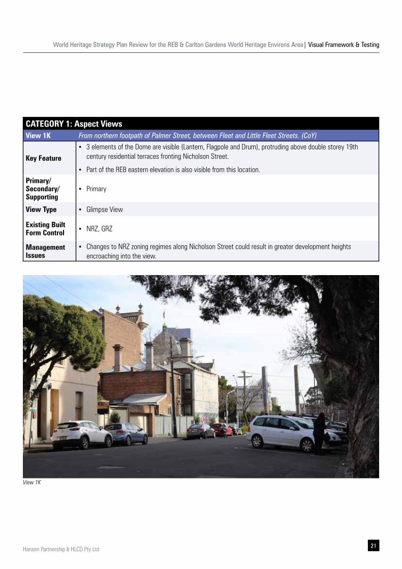
CATEGORY 1: Aspect ViewsView 1K From northern footpath of Palmer Street, between Fleet and Little Fleet Streets. (CoY)
Key Feature
▪ 3 elements of the Dome are visible (Lantern, Flagpole and Drum), protruding above double storey 19th century residential terraces fronting Nicholson Street.
▪ Part of the REB eastern elevation is also visible from this location. Primary/ Secondary/ Supporting
▪ Primary
View Type ▪ Glimpse View
Existing Built Form Control ▪ NRZ, GRZ
Management Issues
▪ Changes to NRZ zoning regimes along Nicholson Street could result in greater development heights encroaching into the view.
View 1K
World Heritage Strategy Plan Review for the REB & Carlton Gardens World Heritage Environs Area| Visual Framework & Testing
22 Hansen Partnership & HLCD Pty Ltd
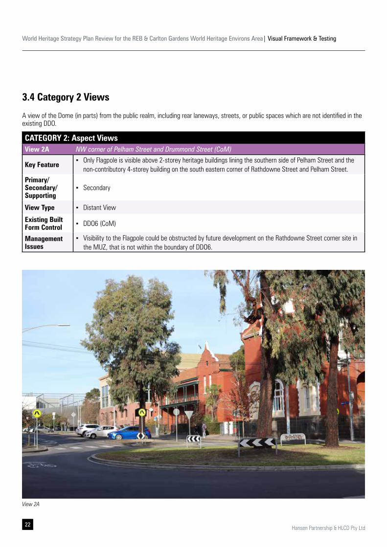
CATEGORY 2: Aspect ViewsView 2A NW corner of Pelham Street and Drummond Street (CoM)
Key Feature ▪ Only Flagpole is visible above 2-storey heritage buildings lining the southern side of Pelham Street and the
non-contributory 4-storey building on the south eastern corner of Rathdowne Street and Pelham Street.Primary/ Secondary/ Supporting
▪ Secondary
View Type ▪ Distant View
Existing Built Form Control ▪ DDO6 (CoM)
Management Issues
▪ Visibility to the Flagpole could be obstructed by future development on the Rathdowne Street corner site in the MUZ, that is not within the boundary of DDO6.
3.4 Category 2 Views
A view of the Dome (in parts) from the public realm, including rear laneways, streets, or public spaces which are not identified in the existing DDO.
View 2A
World Heritage Strategy Plan Review for the REB & Carlton Gardens World Heritage Environs Area| Visual Framework & Testing
23Hansen Partnership & HLCD Pty Ltd
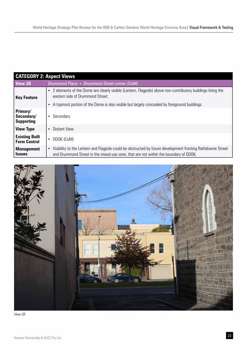
CATEGORY 2: Aspect ViewsView 2B Drummond Place + Drummond Street corner (CoM)
Key Feature
▪ 2 elements of the Dome are clearly visible (Lantern, Flagpole) above non-contributory buildings lining the eastern side of Drummond Street.
▪ A topmost portion of the Dome is also visible but largely concealed by foreground buildings.Primary/ Secondary/ Supporting
▪ Secondary
View Type ▪ Distant View
Existing Built Form Control ▪ DDO6 (CoM)
Management Issues
▪ Visibility to the Lantern and Flagpole could be obstructed by future development fronting Rathdowne Street and Drummond Street in the mixed use zone, that are not within the boundary of DDO6.
View 2B
World Heritage Strategy Plan Review for the REB & Carlton Gardens World Heritage Environs Area| Visual Framework & Testing
24 Hansen Partnership & HLCD Pty Ltd
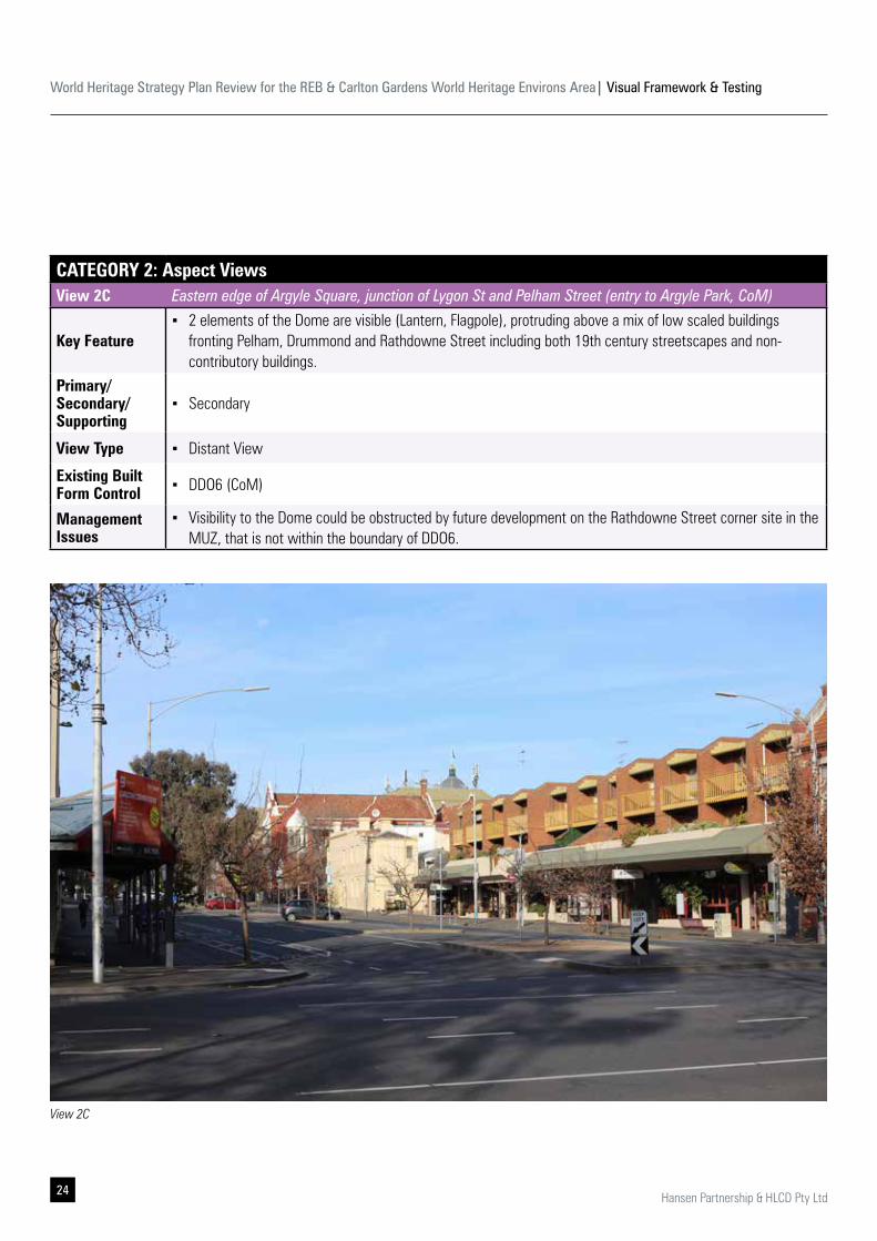
CATEGORY 2: Aspect ViewsView 2C Eastern edge of Argyle Square, junction of Lygon St and Pelham Street (entry to Argyle Park, CoM)
Key Feature ▪ 2 elements of the Dome are visible (Lantern, Flagpole), protruding above a mix of low scaled buildings
fronting Pelham, Drummond and Rathdowne Street including both 19th century streetscapes and non-contributory buildings.
Primary/ Secondary/ Supporting
▪ Secondary
View Type ▪ Distant View
Existing Built Form Control ▪ DDO6 (CoM)
Management Issues
▪ Visibility to the Dome could be obstructed by future development on the Rathdowne Street corner site in the MUZ, that is not within the boundary of DDO6.
View 2C
World Heritage Strategy Plan Review for the REB & Carlton Gardens World Heritage Environs Area| Visual Framework & Testing
25Hansen Partnership & HLCD Pty Ltd
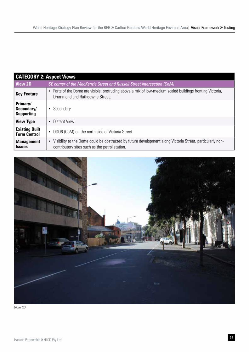
CATEGORY 2: Aspect ViewsView 2D SE corner of the MacKenzie Street and Russell Street intersection (CoM)
Key Feature ▪ Parts of the Dome are visible, protruding above a mix of low-medium scaled buildings fronting Victoria,
Drummond and Rathdowne Street.Primary/ Secondary/ Supporting
▪ Secondary
View Type ▪ Distant View
Existing Built Form Control ▪ DDO6 (CoM) on the north side of Victoria Street.
Management Issues
▪ Visibility to the Dome could be obstructed by future development along Victoria Street, particularly non-contributory sites such as the petrol station.
View 2D
World Heritage Strategy Plan Review for the REB & Carlton Gardens World Heritage Environs Area| Visual Framework & Testing
26 Hansen Partnership & HLCD Pty Ltd
CATEGORY 3: Aspect ViewsView 3A NW corner of Pelham Street and Rathdowne Street (CoM)
Key Feature
▪ Parts of the Dome and the REB western elevation and the Carlton Gardens are visible.
▪ The Melbourne Museum canopy ‘wing’ interrupts view to the Dome.
▪ Street furniture and signages form the foreground and interrupt vista to the Dome.
▪ Some high rises (within the CBD) are in the background. Primary/ Secondary/ Supporting
▪ Primary
View Type ▪ Direct view
Existing Built Form Control
▪ Nil (CoY) – South eastern part of Nicholson St.
▪ GRZ/ NRZ (CoY)– North eastern part of Nicholson St.
▪ DDO10 (CoM)- South part of Victoria St.
Management Issues
▪ High-rise development in the St. Vincent's’s hospital precinct and the north-eastern corner of the CDD and along Victoria Parade may influence the background of the view and the primacy of the Dome.
3.5 Category 3 Views
A view of the REB from within the public realm, including laneways, streets, or public spaces.
View 3A
World Heritage Strategy Plan Review for the REB & Carlton Gardens World Heritage Environs Area| Visual Framework & Testing
27Hansen Partnership & HLCD Pty Ltd
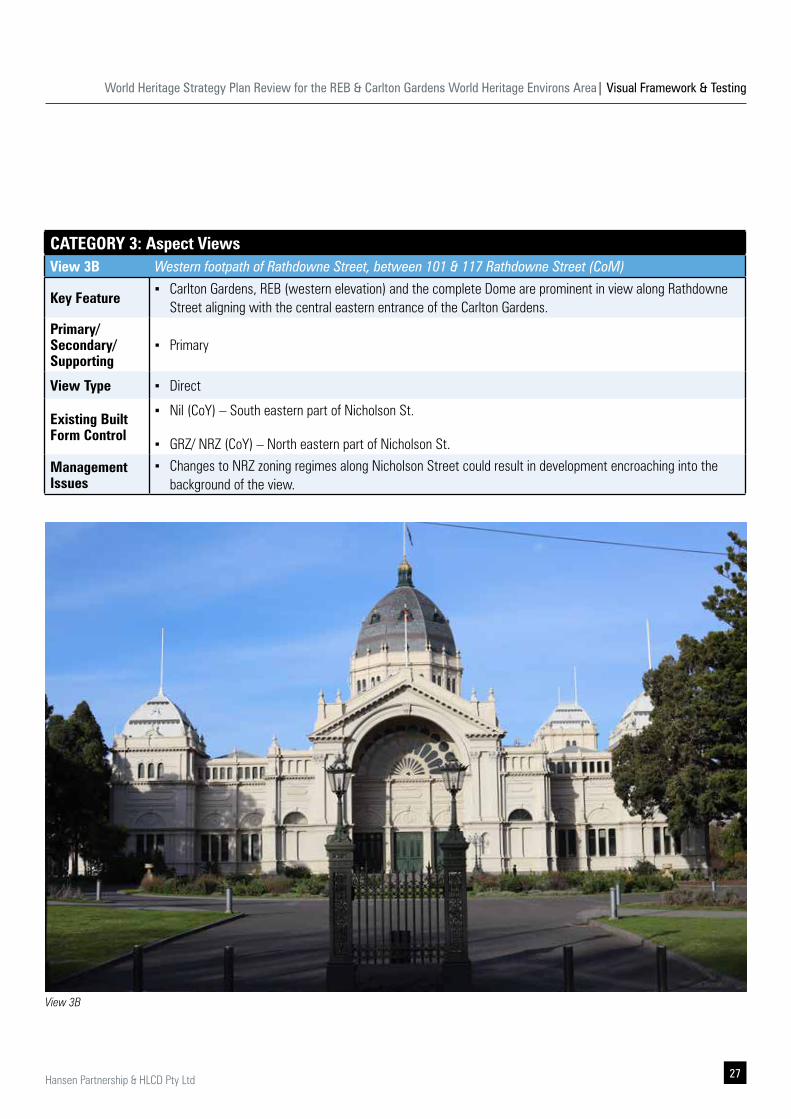
CATEGORY 3: Aspect ViewsView 3B Western footpath of Rathdowne Street, between 101 & 117 Rathdowne Street (CoM)
Key Feature ▪ Carlton Gardens, REB (western elevation) and the complete Dome are prominent in view along Rathdowne
Street aligning with the central eastern entrance of the Carlton Gardens.Primary/ Secondary/ Supporting
▪ Primary
View Type ▪ Direct
Existing Built Form Control
▪ Nil (CoY) – South eastern part of Nicholson St.
▪ GRZ/ NRZ (CoY) – North eastern part of Nicholson St.
Management Issues
▪ Changes to NRZ zoning regimes along Nicholson Street could result in development encroaching into the background of the view.
View 3B
World Heritage Strategy Plan Review for the REB & Carlton Gardens World Heritage Environs Area| Visual Framework & Testing
28 Hansen Partnership & HLCD Pty Ltd
CATEGORY 3: Aspect ViewsView 3C Intersection of Victoria, Latrobe and Spring Street, at the signalised junction and tram stop (CoM)
Key Feature ▪ Carlton Gardens, REB and the complete Dome are visible through the axis of the Grand Allee from footpaths
on both sides of Victoria Street as well as median tram stopsPrimary/ Secondary/ Supporting
▪ Primary
View Type ▪ Direct view
Existing Built Form Control ▪ Nil
Management Issues
▪ The alignment of public transport infrastructure and signage potentially cluttering the foreground of views from the southern footpath.
View 3C
World Heritage Strategy Plan Review for the REB & Carlton Gardens World Heritage Environs Area| Visual Framework & Testing
29Hansen Partnership & HLCD Pty Ltd
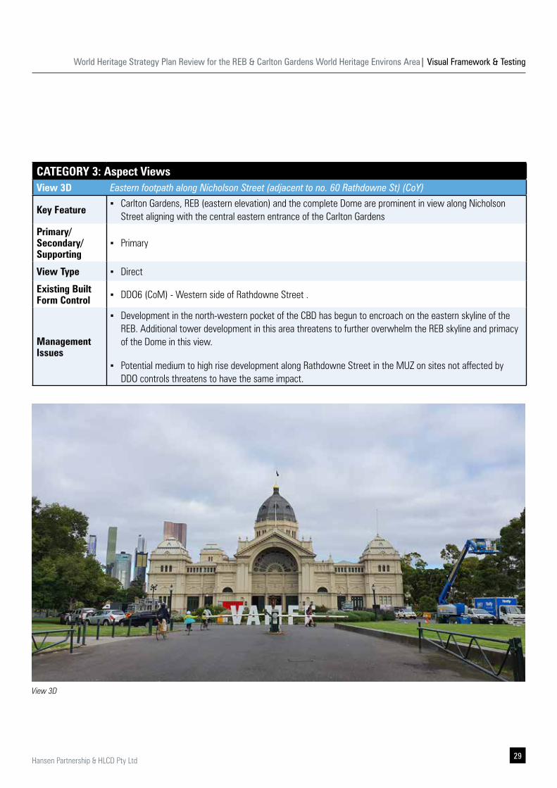
CATEGORY 3: Aspect ViewsView 3D Eastern footpath along Nicholson Street (adjacent to no. 60 Rathdowne St) (CoY)
Key Feature ▪ Carlton Gardens, REB (eastern elevation) and the complete Dome are prominent in view along Nicholson
Street aligning with the central eastern entrance of the Carlton GardensPrimary/ Secondary/ Supporting
▪ Primary
View Type ▪ Direct
Existing Built Form Control ▪ DDO6 (CoM) - Western side of Rathdowne Street .
Management Issues
▪ Development in the north-western pocket of the CBD has begun to encroach on the eastern skyline of the REB. Additional tower development in this area threatens to further overwhelm the REB skyline and primacy of the Dome in this view.
▪ Potential medium to high rise development along Rathdowne Street in the MUZ on sites not affected by DDO controls threatens to have the same impact.
View 3D
World Heritage Strategy Plan Review for the REB & Carlton Gardens World Heritage Environs Area| Visual Framework & Testing
30 Hansen Partnership & HLCD Pty Ltd
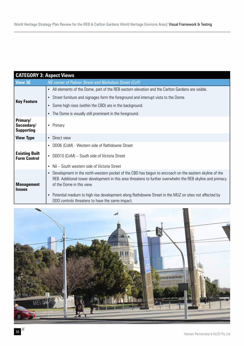
CATEGORY 3: Aspect ViewsView 3E NE corner of Palmer Street and Nicholson Street (CoY)
Key Feature
▪ All elements of the Dome, part of the REB eastern elevation and the Carlton Gardens are visible.
▪ Street furniture and signages form the foreground and interrupt vista to the Dome.
▪ Some high rises (within the CBD) are in the background.
▪ The Dome is visually still prominent in the foreground. Primary/ Secondary/ Supporting
▪ Primary
View Type ▪ Direct view
Existing Built Form Control
▪ DDO6 (CoM) - Western side of Rathdowne Street
▪ DDO10 (CoM) – South side of Victoria Street
▪ Nil – South western side of Victoria Street
Management Issues
▪ Development in the north-western pocket of the CBD has begun to encroach on the eastern skyline of the REB. Additional tower development in this area threatens to further overwhelm the REB skyline and primacy of the Dome in this view.
▪ Potential medium to high rise development along Rathdowne Street in the MUZ on sites not affected by DDO controls threatens to have the same impact.
View 3E
World Heritage Strategy Plan Review for the REB & Carlton Gardens World Heritage Environs Area| Visual Framework & Testing
31Hansen Partnership & HLCD Pty Ltd
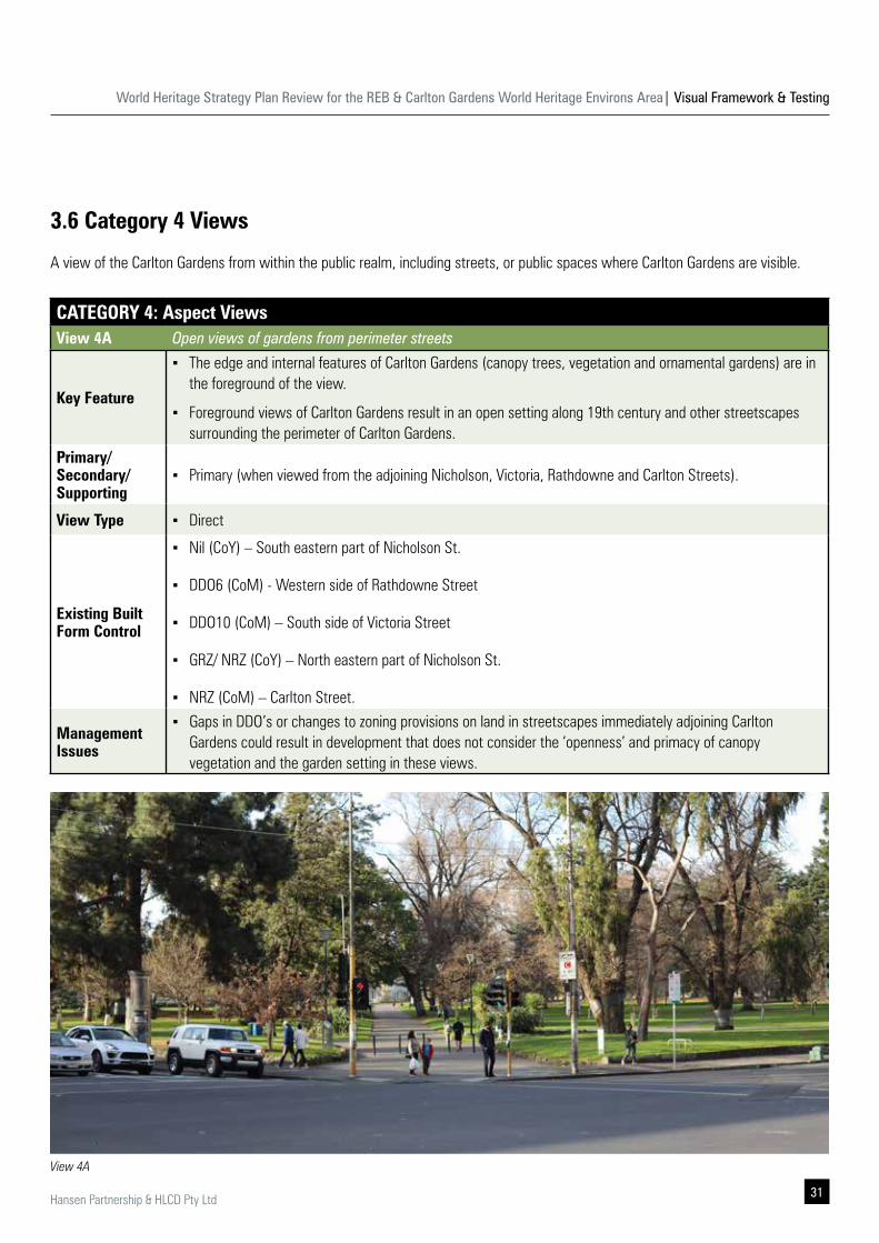
3.6 Category 4 Views
A view of the Carlton Gardens from within the public realm, including streets, or public spaces where Carlton Gardens are visible.
CATEGORY 4: Aspect ViewsView 4A Open views of gardens from perimeter streets
Key Feature
▪ The edge and internal features of Carlton Gardens (canopy trees, vegetation and ornamental gardens) are in the foreground of the view.
▪ Foreground views of Carlton Gardens result in an open setting along 19th century and other streetscapes surrounding the perimeter of Carlton Gardens.
Primary/ Secondary/ Supporting
▪ Primary (when viewed from the adjoining Nicholson, Victoria, Rathdowne and Carlton Streets).
View Type ▪ Direct
Existing Built Form Control
▪ Nil (CoY) – South eastern part of Nicholson St.
▪ DDO6 (CoM) - Western side of Rathdowne Street
▪ DDO10 (CoM) – South side of Victoria Street
▪ GRZ/ NRZ (CoY) – North eastern part of Nicholson St.
▪ NRZ (CoM) – Carlton Street.
Management Issues
▪ Gaps in DDO’s or changes to zoning provisions on land in streetscapes immediately adjoining Carlton Gardens could result in development that does not consider the ‘openness’ and primacy of canopy vegetation and the garden setting in these views.
View 4A
World Heritage Strategy Plan Review for the REB & Carlton Gardens World Heritage Environs Area| Visual Framework & Testing
32 Hansen Partnership & HLCD Pty Ltd
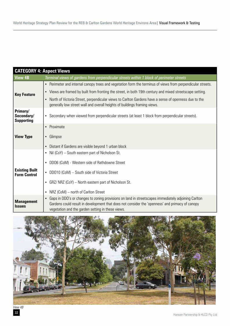
CATEGORY 4: Aspect ViewsView 4B Terminal views of gardens from perpendicular streets within 1 block of perimeter streets
Key Feature
▪ Perimeter and internal canopy trees and vegetation form the terminus of views from perpendicular streets.
▪ Views are framed by built from fronting the street, in both 19th century and mixed streetscape setting.
▪ North of Victoria Street, perpendicular views to Carlton Gardens have a sense of openness due to the generally low street wall and overall heights of buildings framing views.
Primary/ Secondary/ Supporting
▪ Secondary when viewed from perpendicular streets (at least 1 block from perpendicular streets).
View Type
▪ Proximate
▪ Glimpse
▪ Distant if Gardens are visible beyond 1 urban block
Existing Built Form Control
▪ Nil (CoY) – South eastern part of Nicholson St.
▪ DDO6 (CoM) - Western side of Rathdowne Street
▪ DDO10 (CoM) – South side of Victoria Street
▪ GRZ/ NRZ (CoY) – North eastern part of Nicholson St.
▪ NRZ (CoM) – north of Carlton Street
Management Issues
▪ Gaps in DDO’s or changes to zoning provisions on land in streetscapes immediately adjoining Carlton Gardens could result in development that does not consider the ‘openness’ and primacy of canopy vegetation and the garden setting in these views.
Hansen Partnership Pty Ltd 28
CCaatteeggoorryy 44 AAssppeecctt VViieewwss
VViieeww 44BB Terminal views of gardens from perpendicular streets within 1 block of perimeter streets.
KKeeyy FFeeaattuurree Perimeter and internal canopy trees and vegetation form the terminus of views from perpendicular streets. Views are framed by built from fronting the street, in both 19th century and mixed streetscape setting. North of Victoria Street, perpendicular views to the Gardens have a sense of openness due to the
generally low street wall and overall heights of buildings framing views. PPrriimmaarryy// SSeeccoonnddaarryy// SSuuppppoorrttiinngg
Secondary when viewed from perpendicular streets (at least 1 block from perpendicular streets)
VViieeww TTyyppee Proximate Glimpse Distant if Gardens are visible beyond 1 urban block
EExxiissttiinngg BBuuiilltt FFoorrmm CCoonnttrrooll
Nil (CoY) – South eastern part of Nicholson St. DDO6 (CoM) - Western side of Rathdowne Street DDO10 (CoM) – South side of Victoria Street GRZ/ NRZ (CoY) – North eastern part of Nicholson St. NRZ (CoM) – north of Carlton Street
MMaannaaggeemmeenntt IIssssuuee
Gaps in DDO’s or changes to zoning provisions on land in streetscapes immediately adjoining the gardens could result in development that does not consider the ‘openness’ and primacy of canopy vegetation and the garden setting in these views.
EExxiittiinngg ccoonnddiittiioonn
View 4B
World Heritage Strategy Plan Review for the REB & Carlton Gardens World Heritage Environs Area| Visual Framework & Testing
33Hansen Partnership & HLCD Pty Ltd
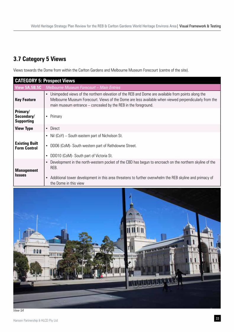
3.7 Category 5 Views
Views towards the Dome from within the Carlton Gardens and Melbourne Museum Forecourt (centre of the site).
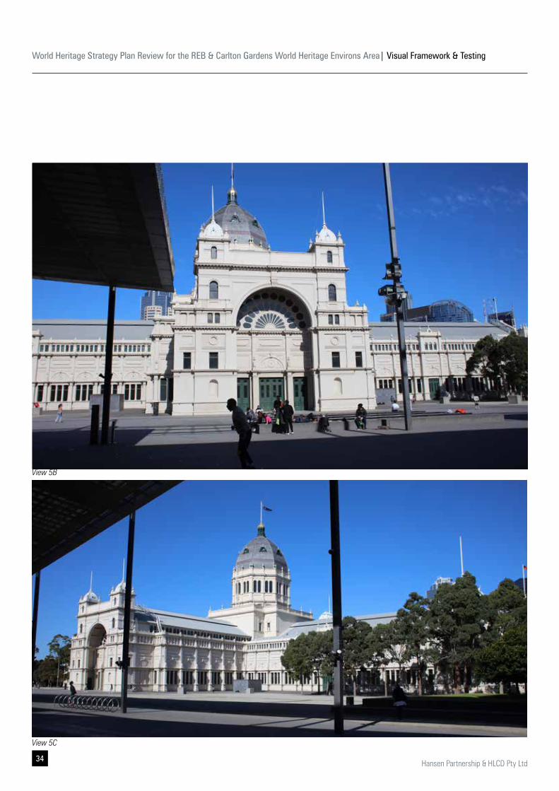
CATEGORY 5: Prospect ViewsView 5A,5B,5C Melbourne Museum Forecourt – Main Entries
Key Feature ▪ Unimpeded views of the northern elevation of the REB and Dome are available from points along the
Melbourne Museum Forecourt. Views of the Dome are less available when viewed perpendicularly from the main museum entrance – concealed by the REB in the foreground.
Primary/ Secondary/ Supporting
▪ Primary
View Type ▪ Direct
Existing Built Form Control
▪ Nil (CoY) – South eastern part of Nicholson St.
▪ DDO6 (CoM)- South western part of Rathdowne Street.
▪ DDO10 (CoM)- South part of Victoria St.
Management Issues
▪ Development in the north-western pocket of the CBD has begun to encroach on the northern skyline of the REB.
▪ Additional tower development in this area threatens to further overwhelm the REB skyline and primacy of the Dome in this view
View 5A
World Heritage Strategy Plan Review for the REB & Carlton Gardens World Heritage Environs Area| Visual Framework & Testing
34 Hansen Partnership & HLCD Pty Ltd
View 5B
View 5C
World Heritage Strategy Plan Review for the REB & Carlton Gardens World Heritage Environs Area| Visual Framework & Testing
35Hansen Partnership & HLCD Pty Ltd
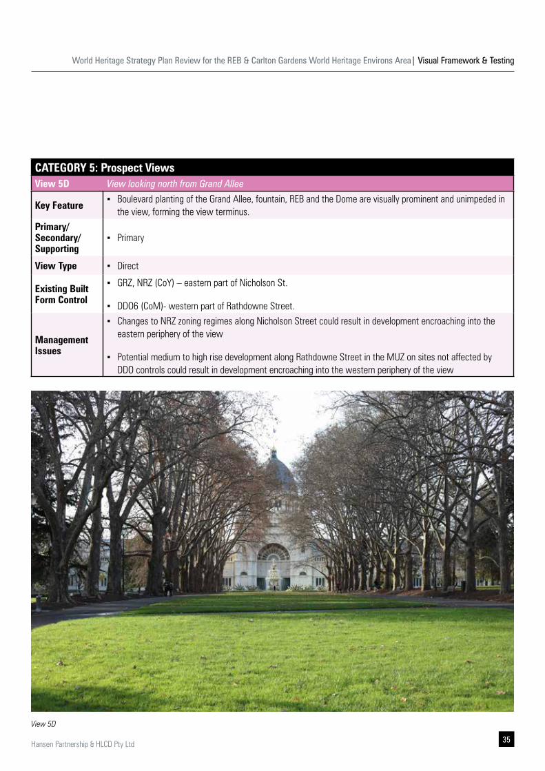
CATEGORY 5: Prospect ViewsView 5D View looking north from Grand Allee
Key Feature ▪ Boulevard planting of the Grand Allee, fountain, REB and the Dome are visually prominent and unimpeded in
the view, forming the view terminus. Primary/ Secondary/ Supporting
▪ Primary
View Type ▪ Direct
Existing Built Form Control
▪ GRZ, NRZ (CoY) – eastern part of Nicholson St.
▪ DDO6 (CoM)- western part of Rathdowne Street.
Management Issues
▪ Changes to NRZ zoning regimes along Nicholson Street could result in development encroaching into the eastern periphery of the view
▪ Potential medium to high rise development along Rathdowne Street in the MUZ on sites not affected by DDO controls could result in development encroaching into the western periphery of the view
View 5D
World Heritage Strategy Plan Review for the REB & Carlton Gardens World Heritage Environs Area| Visual Framework & Testing
36 Hansen Partnership & HLCD Pty Ltd
3.8 Category 6 Views
Views towards the Dome from within the Carlton Gardens and Melbourne Museum Forecourt (centre of the site).
CATEGORY 6: Prospect ViewsView 6A Southern footpath on Carlton Street at designated entries into the Carlton Gardens (CoM + CoY)
Key Feature ▪ Intact 19th century significant streetscape on the north side of Carlton Street.
Primary/ Secondary/ Supporting
▪ Supporting
View Type ▪ Oblique Streetscape
Existing Built Form Control
▪ GRZ, NRZ (CoM) – northern part of Carlton Street.
▪ Existing HO
Management Issues
▪ Contemporary new addition may diminish intact, significant heritage streetscapes, or consistent streetscapes.
▪ Taller development may diminish the sense of openness within the streetscapes surrounding the Carlton Gardens.
▪ GRZ is subject to change
World Heritage Strategy Plan Review for the REB & Carlton Gardens World Heritage Environs Area| Visual Framework & Testing
37Hansen Partnership & HLCD Pty Ltd
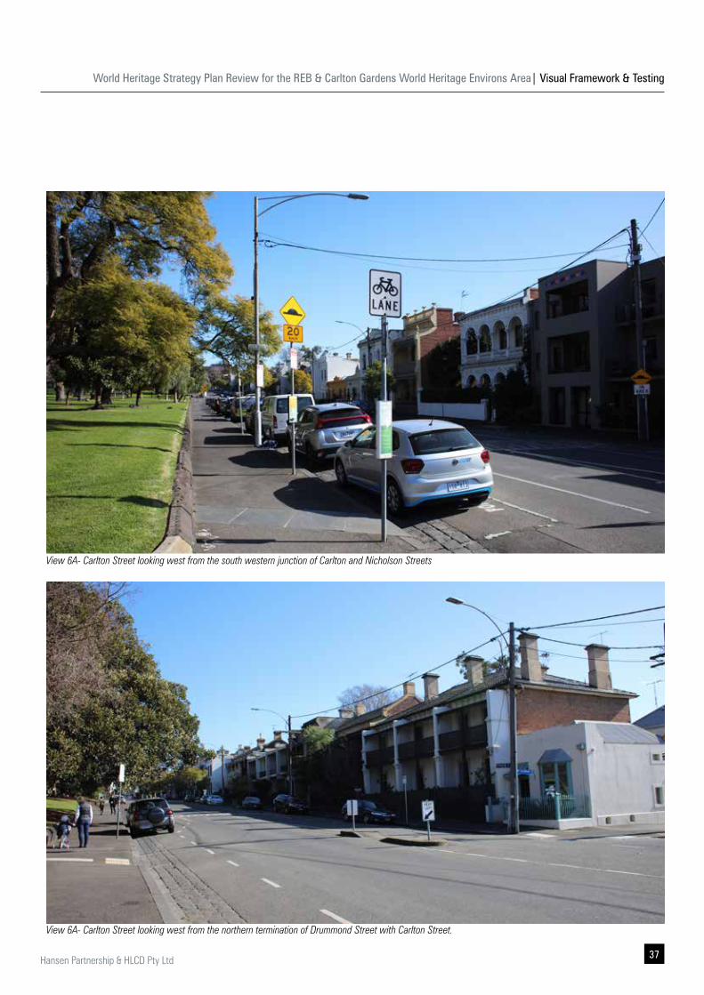
View 6A- Carlton Street looking west from the south western junction of Carlton and Nicholson Streets
View 6A- Carlton Street looking west from the northern termination of Drummond Street with Carlton Street.
World Heritage Strategy Plan Review for the REB & Carlton Gardens World Heritage Environs Area| Visual Framework & Testing
38 Hansen Partnership & HLCD Pty Ltd
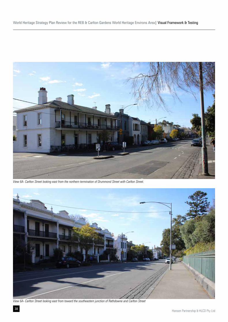
View 6A- Carlton Street looking east from the northern termination of Drummond Street with Carlton Street.
View 6A- Carlton Street looking east from toward the southeastern junction of Rathdowne and Carlton Street
World Heritage Strategy Plan Review for the REB & Carlton Gardens World Heritage Environs Area| Visual Framework & Testing
39Hansen Partnership & HLCD Pty Ltd
CATEGORY 6: Prospect Views
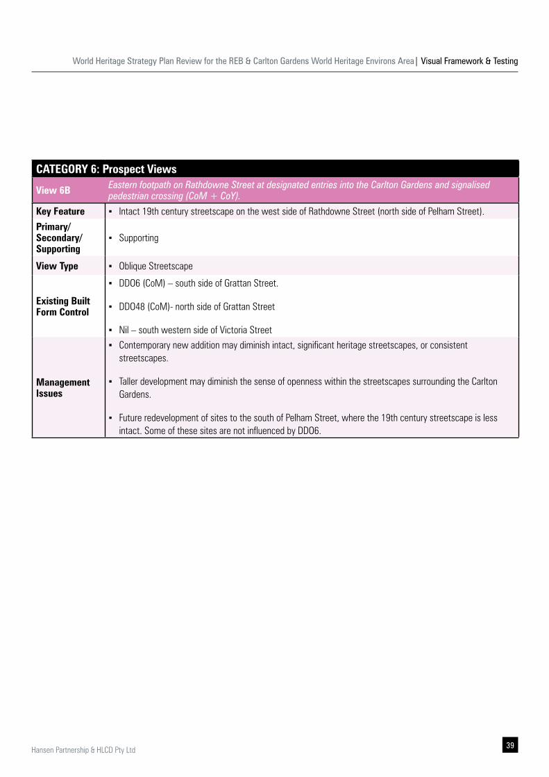
View 6B Eastern footpath on Rathdowne Street at designated entries into the Carlton Gardens and signalised pedestrian crossing (CoM + CoY).
Key Feature ▪ Intact 19th century streetscape on the west side of Rathdowne Street (north side of Pelham Street).
Primary/ Secondary/ Supporting
▪ Supporting
View Type ▪ Oblique Streetscape
Existing Built Form Control
▪ DDO6 (CoM) – south side of Grattan Street.
▪ DDO48 (CoM)- north side of Grattan Street
▪ Nil – south western side of Victoria Street
Management Issues
▪ Contemporary new addition may diminish intact, significant heritage streetscapes, or consistent streetscapes.
▪ Taller development may diminish the sense of openness within the streetscapes surrounding the Carlton Gardens.
▪ Future redevelopment of sites to the south of Pelham Street, where the 19th century streetscape is less intact. Some of these sites are not influenced by DDO6.
World Heritage Strategy Plan Review for the REB & Carlton Gardens World Heritage Environs Area| Visual Framework & Testing
40 Hansen Partnership & HLCD Pty Ltd
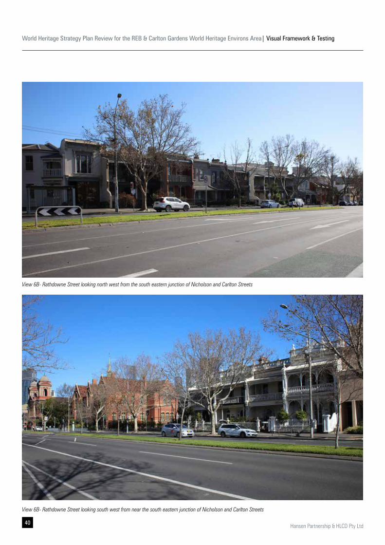
View 6B- Rathdowne Street looking north west from the south eastern junction of Nicholson and Carlton Streets
View 6B- Rathdowne Street looking south west from near the south eastern junction of Nicholson and Carlton Streets
World Heritage Strategy Plan Review for the REB & Carlton Gardens World Heritage Environs Area| Visual Framework & Testing
41Hansen Partnership & HLCD Pty Ltd
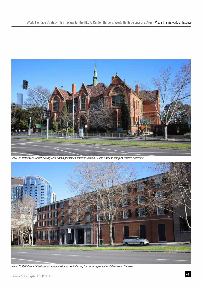
View 6B- Rathdowne Street looking west from a pedestrian entrance into the Carlton Gardens along its western perimeter
View 6B- Rathdowne Street looking south west from central along the western perimeter of the Carlton Gardens
World Heritage Strategy Plan Review for the REB & Carlton Gardens World Heritage Environs Area| Visual Framework & Testing
42 Hansen Partnership & HLCD Pty Ltd
CATEGORY 6: Prospect Views
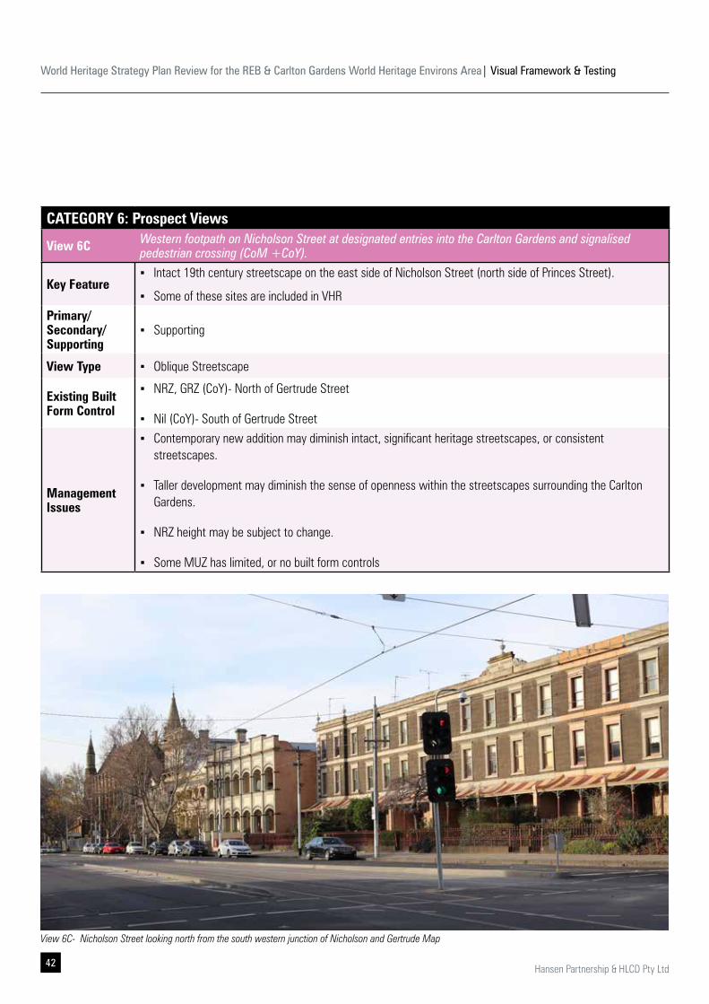
View 6C Western footpath on Nicholson Street at designated entries into the Carlton Gardens and signalised pedestrian crossing (CoM +CoY).
Key Feature ▪ Intact 19th century streetscape on the east side of Nicholson Street (north side of Princes Street).
▪ Some of these sites are included in VHRPrimary/ Secondary/ Supporting
▪ Supporting
View Type ▪ Oblique Streetscape
Existing Built Form Control
▪ NRZ, GRZ (CoY)- North of Gertrude Street
▪ Nil (CoY)- South of Gertrude Street
Management Issues
▪ Contemporary new addition may diminish intact, significant heritage streetscapes, or consistent streetscapes.
▪ Taller development may diminish the sense of openness within the streetscapes surrounding the Carlton Gardens.
▪ NRZ height may be subject to change.
▪ Some MUZ has limited, or no built form controls
View 6C- Nicholson Street looking north from the south western junction of Nicholson and Gertrude Map
World Heritage Strategy Plan Review for the REB & Carlton Gardens World Heritage Environs Area| Visual Framework & Testing
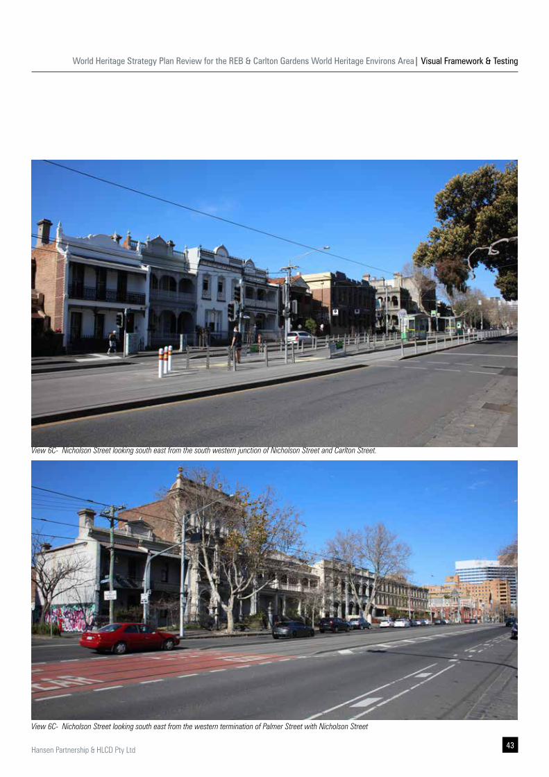
43Hansen Partnership & HLCD Pty Ltd
View 6C- Nicholson Street looking south east from the south western junction of Nicholson Street and Carlton Street.
View 6C- Nicholson Street looking south east from the western termination of Palmer Street with Nicholson Street
World Heritage Strategy Plan Review for the REB & Carlton Gardens World Heritage Environs Area| Visual Framework & Testing
44 Hansen Partnership & HLCD Pty Ltd
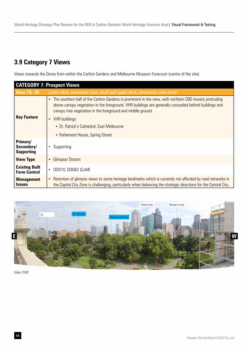
3.9 Category 7 Views
Views towards the Dome from within the Carlton Gardens and Melbourne Museum Forecourt (centre of the site).
CATEGORY 7: Prospect ViewsView 7A, 7B Lower deck, panoramic view south and upper deck, panoramic view south
Key Feature
▪ The southern half of the Carlton Gardens is prominent in the view, with northern CBD towers protruding above canopy vegetation in the foreground. VHR buildings are generally concealed behind buildings and canopy tree vegetation in the foreground and middle ground.
▪ VHR buildings
▪ St. Patrick’s Cathedral, East Melbourne
▪ Parliament House, Spring StreetPrimary/ Secondary/ Supporting
▪ Supporting
View Type ▪ Glimpse/ Distant
Existing Built Form Control ▪ DDO10, DDO62 (CoM)
Management Issues
▪ Retention of glimpse views to some heritage landmarks which is currently not afforded by road networks in the Capital City Zone is challenging, particularly when balancing the strategic directions for the Central City.
View 7A/B
St. Patrick'sSt. Parliament House
E W
Central Axis Shangri La site
World Heritage Strategy Plan Review for the REB & Carlton Gardens World Heritage Environs Area| Visual Framework & Testing
45Hansen Partnership & HLCD Pty Ltd
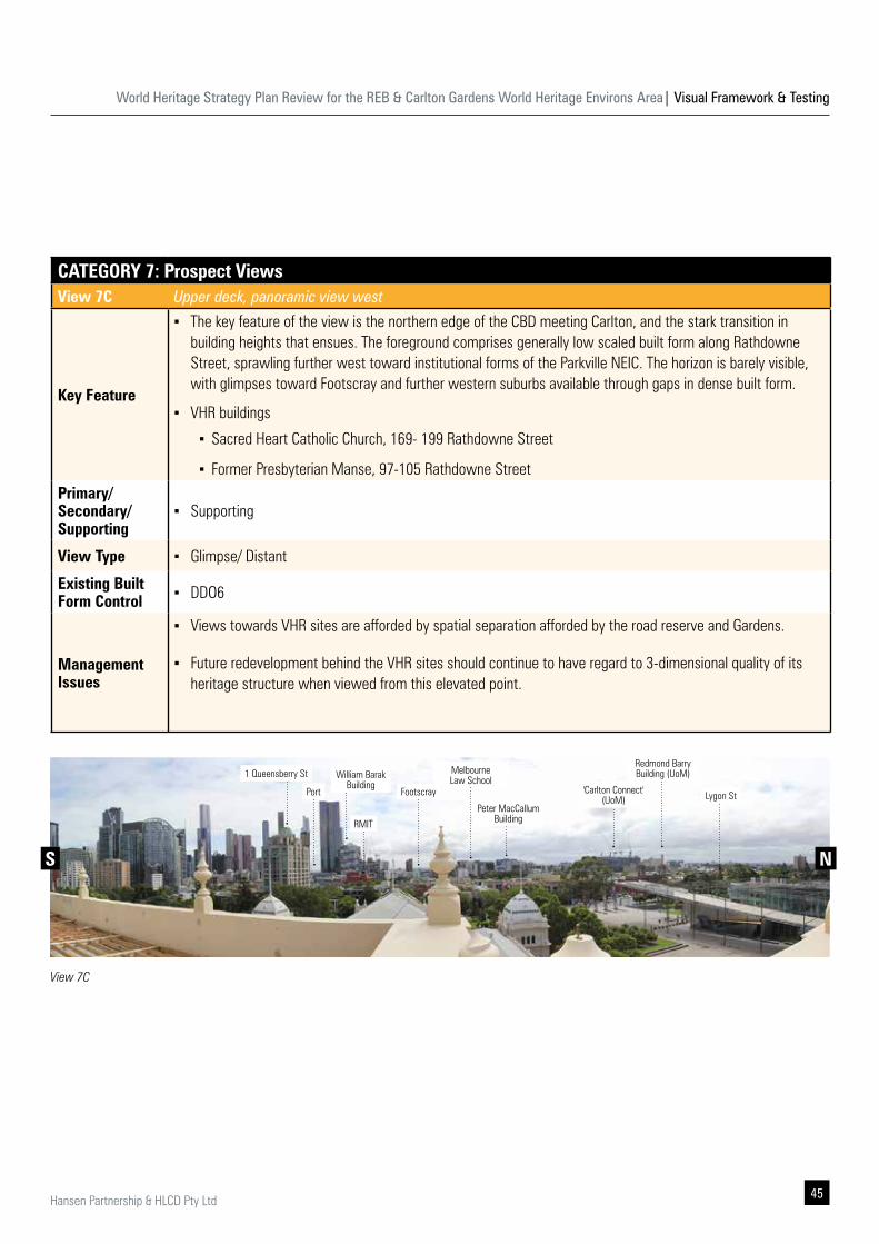
CATEGORY 7: Prospect ViewsView 7C Upper deck, panoramic view west
Key Feature
▪ The key feature of the view is the northern edge of the CBD meeting Carlton, and the stark transition in building heights that ensues. The foreground comprises generally low scaled built form along Rathdowne Street, sprawling further west toward institutional forms of the Parkville NEIC. The horizon is barely visible, with glimpses toward Footscray and further western suburbs available through gaps in dense built form.
▪ VHR buildings
▪ Sacred Heart Catholic Church, 169- 199 Rathdowne Street
▪ Former Presbyterian Manse, 97-105 Rathdowne StreetPrimary/ Secondary/ Supporting
▪ Supporting
View Type ▪ Glimpse/ Distant
Existing Built Form Control ▪ DDO6
Management Issues
▪ Views towards VHR sites are afforded by spatial separation afforded by the road reserve and Gardens.
▪ Future redevelopment behind the VHR sites should continue to have regard to 3-dimensional quality of its heritage structure when viewed from this elevated point.
View 7C
1 Queensberry St
Port Footscray
RMIT
William Barak Building
Redmond Barry Building (UoM)
'Carlton Connect' (UoM) Lygon St
Melbourne Law School
S N
Peter MacCallum Building
World Heritage Strategy Plan Review for the REB & Carlton Gardens World Heritage Environs Area| Visual Framework & Testing
46 Hansen Partnership & HLCD Pty Ltd
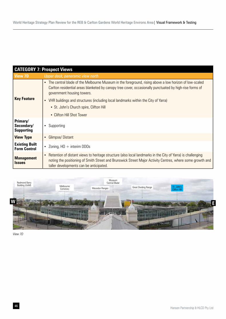
CATEGORY 7: Prospect ViewsView 7D Upper deck, panoramic view north
Key Feature
▪ The central blade of the Melbourne Museum in the foreground, rising above a low horizon of low-scaled Carlton residential areas blanketed by canopy tree cover, occasionally punctuated by high-rise forms of government housing towers.
▪ VHR buildings and structures (including local landmarks within the City of Yarra)
▪ St. John’s Church spire, Clifton Hill
▪ Clifton Hill Shot TowerPrimary/ Secondary/ Supporting
▪ Supporting
View Type ▪ Glimpse/ Distant
Existing Built Form Control ▪ Zoning, HO + interim DDOs
Management Issues
▪ Retention of distant views to heritage structure (also local landmarks in the City of Yarra) is challenging noting the positioning of Smith Street and Brunswick Street Major Activity Centres, where some growth and taller developments can be anticipated.
View 7D
Redmond Barry Building (UoM) Melbourne
Cemetary Macedon Ranges
Museum 'Central Blade'
Great Dividing Range St. John's Clifton Hill
EW
World Heritage Strategy Plan Review for the REB & Carlton Gardens World Heritage Environs Area| Visual Framework & Testing
47Hansen Partnership & HLCD Pty Ltd
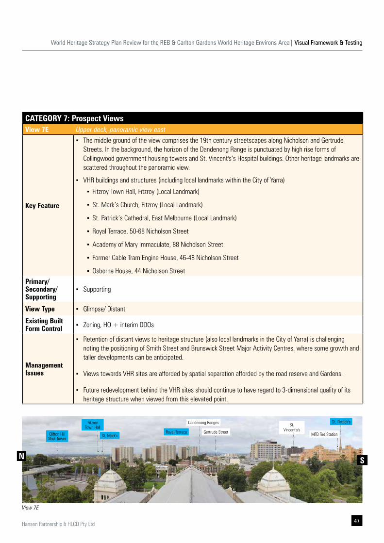
CATEGORY 7: Prospect ViewsView 7E Upper deck, panoramic view east
Key Feature
▪ The middle ground of the view comprises the 19th century streetscapes along Nicholson and Gertrude Streets. In the background, the horizon of the Dandenong Range is punctuated by high rise forms of Collingwood government housing towers and St. Vincent's’s Hospital buildings. Other heritage landmarks are scattered throughout the panoramic view.
▪ VHR buildings and structures (including local landmarks within the City of Yarra)
▪ Fitzroy Town Hall, Fitzroy (Local Landmark)
▪ St. Mark’s Church, Fitzroy (Local Landmark)
▪ St. Patrick’s Cathedral, East Melbourne (Local Landmark)
▪ Royal Terrace, 50-68 Nicholson Street
▪ Academy of Mary Immaculate, 88 Nicholson Street
▪ Former Cable Tram Engine House, 46-48 Nicholson Street
▪ Osborne House, 44 Nicholson StreetPrimary/ Secondary/ Supporting
▪ Supporting
View Type ▪ Glimpse/ Distant
Existing Built Form Control ▪ Zoning, HO + interim DDOs
Management Issues
▪ Retention of distant views to heritage structure (also local landmarks in the City of Yarra) is challenging noting the positioning of Smith Street and Brunswick Street Major Activity Centres, where some growth and taller developments can be anticipated.
▪ Views towards VHR sites are afforded by spatial separation afforded by the road reserve and Gardens.
▪ Future redevelopment behind the VHR sites should continue to have regard to 3-dimensional quality of its heritage structure when viewed from this elevated point.
View 7E
St. Patrick'sSt.
Vincent's's Gertrude Street
Dandenong Ranges
Royal TerraceClifton Hill Shot Tower
Fitzroy Town Hall
St. Mark's
N S
MFB Fire Station
World Heritage Strategy Plan Review for the REB & Carlton Gardens World Heritage Environs Area| Visual Framework & Testing
48 Hansen Partnership & HLCD Pty Ltd
4.0 Built Form Testing 4 .1 Purpose & Approach
Hansen had prepared 3-Dimensional massing model for key areas to test the impact of existing DDOs; recent development trajectory; and locations with an absence of built form control for primary views to the Dome, REB and its 19th century setting.
The built form tests demonstrate visual implications of potential built form outcomes to enable assessment and to determine how the preferred outcome meets the urban design principles. Details of the modelling approach and methodology are provided below.
▪ The development and use of such 3D massing model is common for strategic built form work of this kind to determine the general relationships between new urban form (various options and scenarios), primary views from identified vantage points discussed in Chapter 3 with input from HLCD.
▪ The massing model utilised is ‘fit for purpose’ for a broad precinct of this nature. It does not rely on detailed site survey data, rather more general available contour, landform and cadastral information provided by DELWP.
▪ Existing development and recent development approvals 3D model are also provided by DELWP. They are depicted as massing representations and do not seek to represent existing building detail, in terms of accurate appearance, materiality, etc.
▪ The massing model for the purpose of this built form testing was prepared in SketchUp Pro 2018 and 2019. Views were taken at eye level, 1.5m from ground level and were compared against existing photographs.
▪ It is also noted that the 3D model has not included any existing vegetation. The basis of the model (ie. Site boundaries, levels and existing vegetation) is not as accurate as one generated with a detailed site survey, or via photomontages.
▪ For the purpose of the built form testing on specific sites, where there is absence of built form, controls were modelled based on a typical 3.5m floor to floor height
Following on from the documentation and analysis of various views and vistas in Section 4.0, a critical follow on task was to undertake built form testing to determine the implications of existing built form control regime, or the lack of one in protecting primary prospect and aspect views and vistas.
The built form testing was not intended to be a comprehensive Built Form Review of all sites within the WHEA. Rather, it was focused around areas where primary views and key supporting views are available from and need to be protected.
World Heritage Strategy Plan Review for the REB & Carlton Gardens World Heritage Environs Area| Visual Framework & Testing
49Hansen Partnership & HLCD Pty Ltd
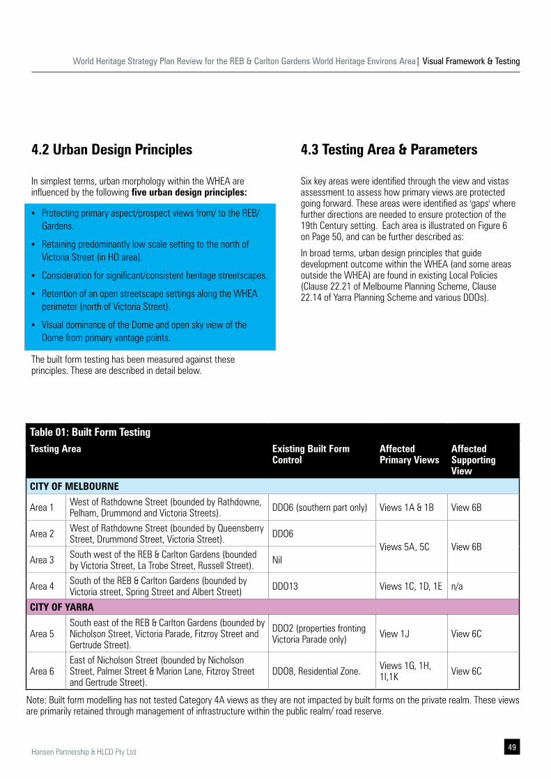
4.3 Testing Area & Parameters
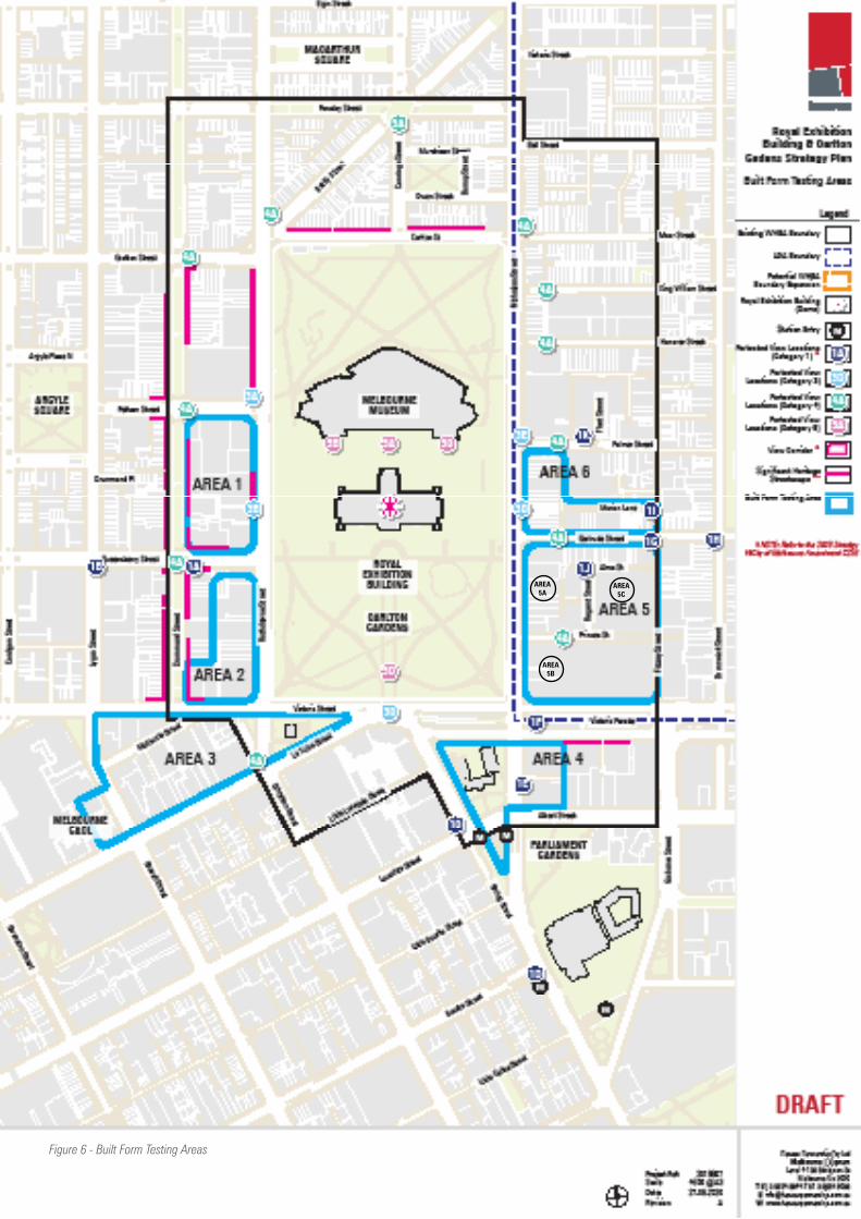
Six key areas were identified through the view and vistas assessment to assess how primary views are protected going forward. These areas were identified as 'gaps' where further directions are needed to ensure protection of the 19th Century setting. Each area is illustrated on Figure 6 on Page 50, and can be further described as:
In broad terms, urban design principles that guide development outcome within the WHEA (and some areas outside the WHEA) are found in existing Local Policies (Clause 22.21 of Melbourne Planning Scheme, Clause 22.14 of Yarra Planning Scheme and various DDOs).
4.2 Urban Design Principles
In simplest terms, urban morphology within the WHEA are influenced by the following five urban design principles:
▪ Protecting primary aspect/prospect views from/ to the REB/ Gardens.
▪ Retaining predominantly low scale setting to the north of Victoria Street (in HO area).
▪ Consideration for significant/consistent heritage streetscapes.
▪ Retention of an open streetscape settings along the WHEA perimeter (north of Victoria Street).
▪ Visual dominance of the Dome and open sky view of the Dome from primary vantage points.
The built form testing has been measured against these principles. These are described in detail below.
Table 01: Built Form TestingTesting Area Existing Built Form
ControlAffected Primary Views
Affected Supporting View
CITY OF MELBOURNE
Area 1 West of Rathdowne Street (bounded by Rathdowne, Pelham, Drummond and Victoria Streets). DDO6 (southern part only) Views 1A & 1B View 6B
Area 2 West of Rathdowne Street (bounded by Queensberry Street, Drummond Street, Victoria Street). DDO6
Views 5A, 5C View 6BArea 3 South west of the REB & Carlton Gardens (bounded
by Victoria Street, La Trobe Street, Russell Street). Nil
Area 4 South of the REB & Carlton Gardens (bounded by Victoria street, Spring Street and Albert Street) DDO13 Views 1C, 1D, 1E n/a
CITY OF YARRA
Area 5South east of the REB & Carlton Gardens (bounded by Nicholson Street, Victoria Parade, Fitzroy Street and Gertrude Street).
DDO2 (properties fronting Victoria Parade only) View 1J View 6C
Area 6East of Nicholson Street (bounded by Nicholson Street, Palmer Street & Marion Lane, Fitzroy Street and Gertrude Street).
DDO8, Residential Zone. Views 1G, 1H, 1I,1K View 6C
Note: Built form modelling has not tested Category 4A views as they are not impacted by built forms on the private realm. These views are primarily retained through management of infrastructure within the public realm/ road reserve.
World Heritage Strategy Plan Review for the REB & Carlton Gardens World Heritage Environs Area| Visual Framework & Testing
50 Hansen Partnership & HLCD Pty Ltd
Figure 6 - Built Form Testing Areas
AREA 5B
AREA 5A
AREA 5C
World Heritage Strategy Plan Review for the REB & Carlton Gardens World Heritage Environs Area| Visual Framework & Testing
51Hansen Partnership & HLCD Pty Ltd
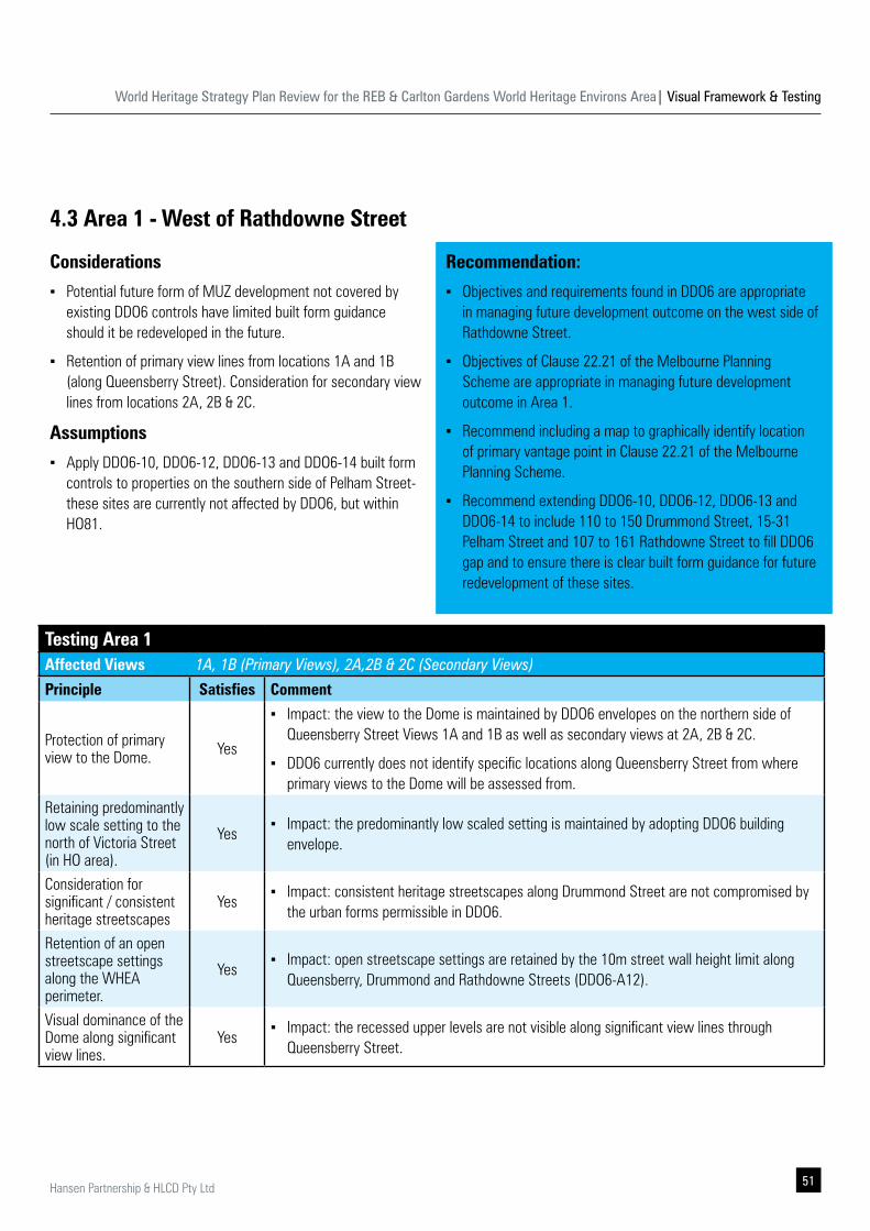
4.3 Area 1 - West of Rathdowne Street
Considerations
▪ Potential future form of MUZ development not covered by existing DDO6 controls have limited built form guidance should it be redeveloped in the future.
▪ Retention of primary view lines from locations 1A and 1B (along Queensberry Street). Consideration for secondary view lines from locations 2A, 2B & 2C.
Assumptions
▪ Apply DDO6-10, DDO6-12, DDO6-13 and DDO6-14 built form controls to properties on the southern side of Pelham Street- these sites are currently not affected by DDO6, but within HO81.
Testing Area 1Affected Views 1A, 1B (Primary Views), 2A,2B & 2C (Secondary Views)
Principle Satisfies Comment
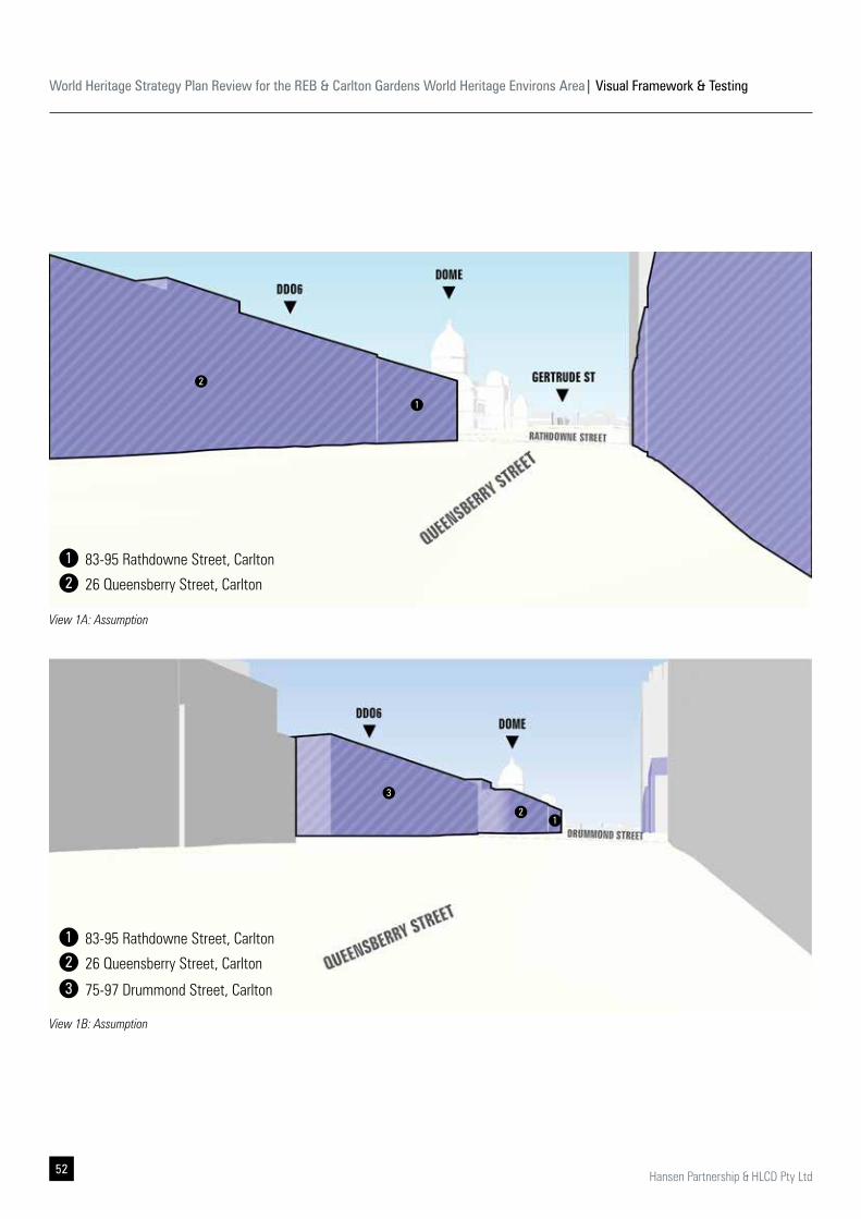
Protection of primary view to the Dome. Yes
▪ Impact: the view to the Dome is maintained by DDO6 envelopes on the northern side of Queensberry Street Views 1A and 1B as well as secondary views at 2A, 2B & 2C.
▪ DDO6 currently does not identify specific locations along Queensberry Street from where primary views to the Dome will be assessed from.
Retaining predominantly low scale setting to the north of Victoria Street (in HO area).
Yes ▪ Impact: the predominantly low scaled setting is maintained by adopting DDO6 building
envelope.
Consideration for significant / consistent heritage streetscapes
Yes ▪ Impact: consistent heritage streetscapes along Drummond Street are not compromised by
the urban forms permissible in DDO6.
Retention of an open streetscape settings along the WHEA perimeter.
Yes ▪ Impact: open streetscape settings are retained by the 10m street wall height limit along
Queensberry, Drummond and Rathdowne Streets (DDO6-A12).
Visual dominance of the Dome along significant view lines.
Yes ▪ Impact: the recessed upper levels are not visible along significant view lines through
Queensberry Street.
Recommendation:
▪ Objectives and requirements found in DDO6 are appropriate in managing future development outcome on the west side of Rathdowne Street.
▪ Objectives of Clause 22.21 of the Melbourne Planning Scheme are appropriate in managing future development outcome in Area 1.
▪ Recommend including a map to graphically identify location of primary vantage point in Clause 22.21 of the Melbourne Planning Scheme.
▪ Recommend extending DDO6-10, DDO6-12, DDO6-13 and DDO6-14 to include 110 to 150 Drummond Street, 15-31 Pelham Street and 107 to 161 Rathdowne Street to fill DDO6 gap and to ensure there is clear built form guidance for future redevelopment of these sites.
World Heritage Strategy Plan Review for the REB & Carlton Gardens World Heritage Environs Area| Visual Framework & Testing
52 Hansen Partnership & HLCD Pty Ltd
View 1A: Assumption
View 1B: Assumption
1
12
3
2
83-95 Rathdowne Street, Carlton
83-95 Rathdowne Street, Carlton
26 Queensberry Street, Carlton
26 Queensberry Street, Carlton
75-97 Drummond Street, Carlton
1
1
2
2
3
World Heritage Strategy Plan Review for the REB & Carlton Gardens World Heritage Environs Area| Visual Framework & Testing
53Hansen Partnership & HLCD Pty Ltd
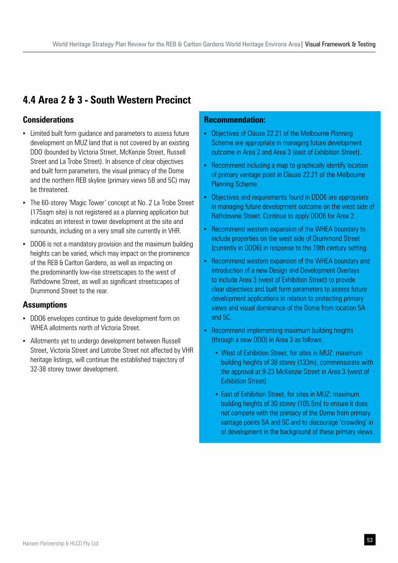
4.4 Area 2 & 3 - South Western Precinct
Considerations
▪ Limited built form guidance and parameters to assess future development on MUZ land that is not covered by an existing DDO (bounded by Victoria Street, McKenzie Street, Russell Street and La Trobe Street). In absence of clear objectives and built form parameters, the visual primacy of the Dome and the northern REB skyline (primary views 5B and 5C) may be threatened.
▪ The 60-storey ‘Magic Tower’ concept at No. 2 La Trobe Street (175sqm site) is not registered as a planning application but indicates an interest in tower development at the site and surrounds, including on a very small site currently in VHR.
▪ DDO6 is not a mandatory provision and the maximum building heights can be varied, which may impact on the prominence of the REB & Carlton Gardens, as well as impacting on the predominantly low-rise streetscapes to the west of Rathdowne Street, as well as significant streetscapes of Drummond Street to the rear.
Assumptions
▪ DDO6 envelopes continue to guide development form on WHEA allotments north of Victoria Street.
▪ Allotments yet to undergo development between Russell Street, Victoria Street and Latrobe Street not affected by VHR heritage listings, will continue the established trajectory of 32-38 storey tower development.
Recommendation:
▪ Objectives of Clause 22.21 of the Melbourne Planning Scheme are appropriate in managing future development outcome in Area 2 and Area 3 (east of Exhibition Street).
▪ Recommend including a map to graphically identify location of primary vantage point in Clause 22.21 of the Melbourne Planning Scheme.
▪ Objectives and requirements found in DDO6 are appropriate in managing future development outcome on the west side of Rathdowne Street. Continue to apply DDO6 for Area 2.
▪ Recommend western expansion of the WHEA boundary to include properties on the west side of Drummond Street (currently in DDO6) in response to the 19th century setting.
▪ Recommend western expansion of the WHEA boundary and introduction of a new Design and Development Overlays to include Area 3 (west of Exhibition Street) to provide clear objectives and built form parameters to assess future development applications in relation to protecting primary views and visual dominance of the Dome from location 5A and 5C.
▪ Recommend implementing maximum building heights (through a new DDO) in Area 3 as follows:
▪ West of Exhibition Street, for sites in MUZ: maximum building heights of 38 storey (133m), commensurate with the approval at 9-23 McKenzie Street in Area 3 (west of Exhibition Street).
▪ East of Exhibition Street, for sites in MUZ: maximum building heights of 30 storey (105.5m) to ensure it does not compete with the primacy of the Dome from primary vantage points 5A and 5C and to discourage ‘crowding’ in of development in the background of these primary views.
World Heritage Strategy Plan Review for the REB & Carlton Gardens World Heritage Environs Area| Visual Framework & Testing
54 Hansen Partnership & HLCD Pty Ltd
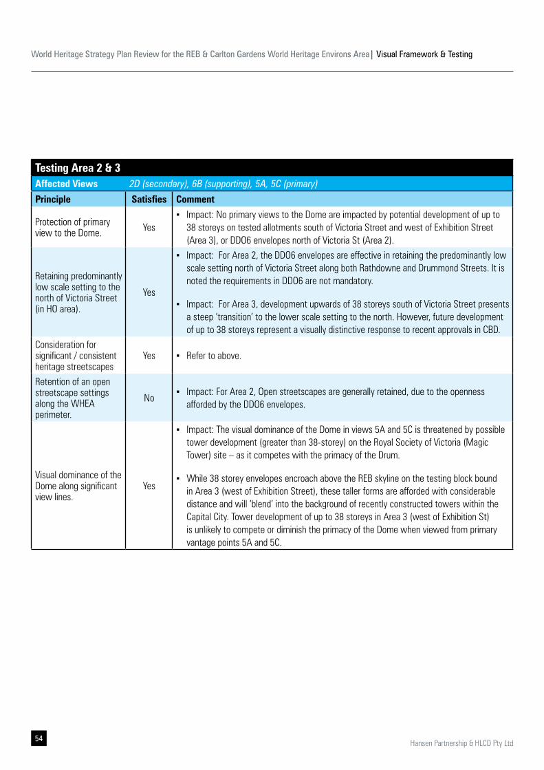
Testing Area 2 & 3Affected Views 2D (secondary), 6B (supporting), 5A, 5C (primary)
Principle Satisfies Comment
Protection of primary view to the Dome. Yes
▪ Impact: No primary views to the Dome are impacted by potential development of up to 38 storeys on tested allotments south of Victoria Street and west of Exhibition Street (Area 3), or DDO6 envelopes north of Victoria St (Area 2).
Retaining predominantly low scale setting to the north of Victoria Street (in HO area).
Yes
▪ Impact: For Area 2, the DDO6 envelopes are effective in retaining the predominantly low scale setting north of Victoria Street along both Rathdowne and Drummond Streets. It is noted the requirements in DDO6 are not mandatory.
▪ Impact: For Area 3, development upwards of 38 storeys south of Victoria Street presents a steep ‘transition’ to the lower scale setting to the north. However, future development of up to 38 storeys represent a visually distinctive response to recent approvals in CBD.
Consideration for significant / consistent heritage streetscapes
Yes ▪ Refer to above.
Retention of an open streetscape settings along the WHEA perimeter.
No ▪ Impact: For Area 2, Open streetscapes are generally retained, due to the openness
afforded by the DDO6 envelopes.
Visual dominance of the Dome along significant view lines.
Yes
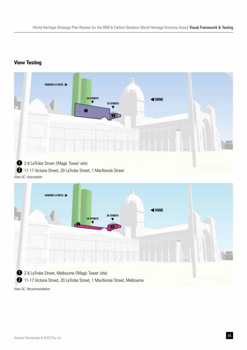
▪ Impact: The visual dominance of the Dome in views 5A and 5C is threatened by possible tower development (greater than 38-storey) on the Royal Society of Victoria (Magic Tower) site – as it competes with the primacy of the Drum.
▪ While 38 storey envelopes encroach above the REB skyline on the testing block bound in Area 3 (west of Exhibition Street), these taller forms are afforded with considerable distance and will ‘blend’ into the background of recently constructed towers within the Capital City. Tower development of up to 38 storeys in Area 3 (west of Exhibition St) is unlikely to compete or diminish the primacy of the Dome when viewed from primary vantage points 5A and 5C.
World Heritage Strategy Plan Review for the REB & Carlton Gardens World Heritage Environs Area| Visual Framework & Testing
55Hansen Partnership & HLCD Pty Ltd
View 5C: Assumption
2-8 LaTrobe Street ('Magic Tower' site)
2-8 LaTrobe Street, Melbourne ('Magic Tower' site)
11-17 Victoria Street, 20 LaTrobe Street, 1 MacKenzie Street
11-17 Victoria Street, 20 LaTrobe Street, 1 MacKenzie Street, Melbourne
View 5C: Recommendation
View Testing
1
1
12
2
1
2
2
World Heritage Strategy Plan Review for the REB & Carlton Gardens World Heritage Environs Area| Visual Framework & Testing
56 Hansen Partnership & HLCD Pty Ltd
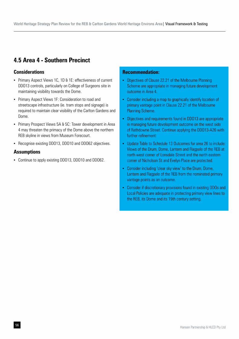
4.5 Area 4 - Southern Precinct
Considerations
▪ Primary Aspect Views 1C, 1D & 1E: effectiveness of current DDO13 controls, particularly on College of Surgeons site in maintaining visibility towards the Dome.
▪ Primary Aspect Views 1F: Consideration to road and streetscape infrastructure (ie. tram stops and signage) is required to maintain clear visibility of the Carlton Gardens and Dome.
▪ Primary Prospect Views 5A & 5C: Tower development in Area 4 may threaten the primacy of the Dome above the northern REB skyline in views from Museum Forecourt.
▪ Recognise existing DDO13, DDO10 and DDO62 objectives.
Assumptions
▪ Continue to apply existing DDO13, DDO10 and DDO62.
Recommendation:
▪ Objectives of Clause 22.21 of the Melbourne Planning Scheme are appropriate in managing future development outcome in Area 4.
▪ Consider including a map to graphically identify location of primary vantage point in Clause 22.21 of the Melbourne Planning Scheme.
▪ Objectives and requirements found in DDO13 are appropriate in managing future development outcome on the west side of Rathdowne Street. Continue applying the DDO13-A26 with further refinement:
▪ Update Table to Schedule 13 Outcomes for area 26 to include: Views of the Drum, Dome, Lantern and Flagpole of the REB at north west corner of Lonsdale Street and the north eastern corner of Nicholson St and Evelyn Place are protected.
▪ Consider including ‘clear sky view’ to the Drum, Dome, Lantern and Flagpole of the REB from the nominated primary vantage points as an outcome.
▪ Consider if discretionary provisions found in existing DDOs and Local Policies are adequate in protecting primary view lines to the REB, its Dome and its 19th century setting.
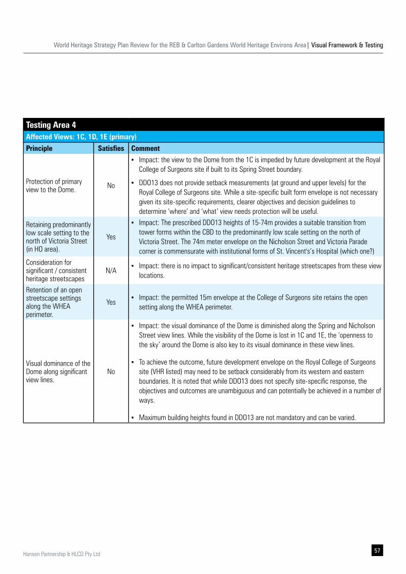
World Heritage Strategy Plan Review for the REB & Carlton Gardens World Heritage Environs Area| Visual Framework & Testing
57Hansen Partnership & HLCD Pty Ltd
Testing Area 4Affected Views: 1C, 1D, 1E (primary)
Principle Satisfies Comment
Protection of primary view to the Dome. No
▪ Impact: the view to the Dome from the 1C is impeded by future development at the Royal College of Surgeons site if built to its Spring Street boundary.
▪ DDO13 does not provide setback measurements (at ground and upper levels) for the Royal College of Surgeons site. While a site-specific built form envelope is not necessary given its site-specific requirements, clearer objectives and decision guidelines to determine ‘where’ and ‘what’ view needs protection will be useful.
Retaining predominantly low scale setting to the north of Victoria Street (in HO area).
Yes
▪ Impact: The prescribed DDO13 heights of 15-74m provides a suitable transition from tower forms within the CBD to the predominantly low scale setting on the north of Victoria Street. The 74m meter envelope on the Nicholson Street and Victoria Parade corner is commensurate with institutional forms of St. Vincent's’s Hospital (which one?)
Consideration for significant / consistent heritage streetscapes
N/A ▪ Impact: there is no impact to significant/consistent heritage streetscapes from these view
locations.
Retention of an open streetscape settings along the WHEA perimeter.
Yes ▪ Impact: the permitted 15m envelope at the College of Surgeons site retains the open
setting along the WHEA perimeter.
Visual dominance of the Dome along significant view lines.
No
▪ Impact: the visual dominance of the Dome is diminished along the Spring and Nicholson Street view lines. While the visibility of the Dome is lost in 1C and 1E, the ‘openness to the sky’ around the Dome is also key to its visual dominance in these view lines.
▪ To achieve the outcome, future development envelope on the Royal College of Surgeons site (VHR listed) may need to be setback considerably from its western and eastern boundaries. It is noted that while DDO13 does not specify site-specific response, the objectives and outcomes are unambiguous and can potentially be achieved in a number of ways.
▪ Maximum building heights found in DDO13 are not mandatory and can be varied.
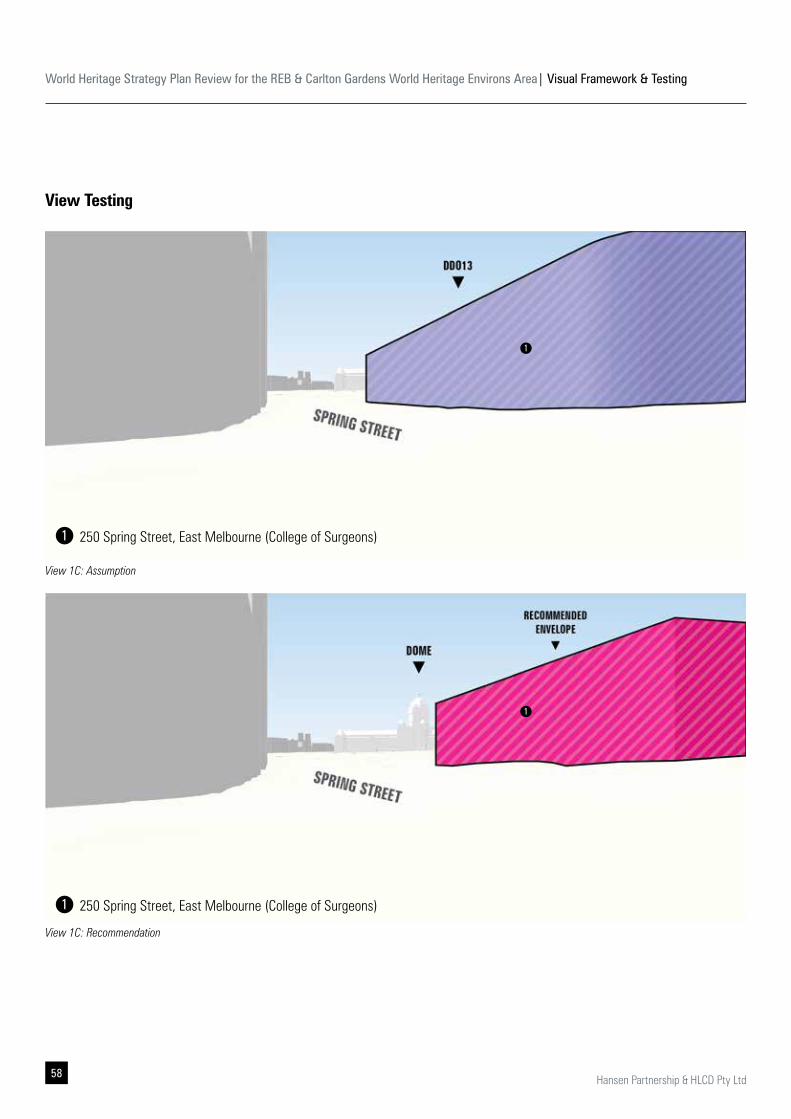
World Heritage Strategy Plan Review for the REB & Carlton Gardens World Heritage Environs Area| Visual Framework & Testing
58 Hansen Partnership & HLCD Pty Ltd
View 1C: Assumption
View 1C: Recommendation
View Testing
1
1
250 Spring Street, East Melbourne (College of Surgeons)
250 Spring Street, East Melbourne (College of Surgeons)
1
1
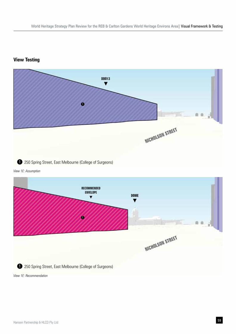
World Heritage Strategy Plan Review for the REB & Carlton Gardens World Heritage Environs Area| Visual Framework & Testing
59Hansen Partnership & HLCD Pty Ltd
View 1E: Assumption
View 1E: Recommendation
View Testing
1
1
250 Spring Street, East Melbourne (College of Surgeons)
250 Spring Street, East Melbourne (College of Surgeons)
1
1
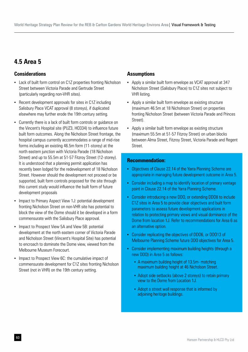
World Heritage Strategy Plan Review for the REB & Carlton Gardens World Heritage Environs Area| Visual Framework & Testing
60 Hansen Partnership & HLCD Pty Ltd
4.5 Area 5
Considerations
▪ Lack of built form control on C1Z properties fronting Nicholson Street between Victoria Parade and Gertrude Street (particularly regarding non-VHR sites).
▪ Recent development approvals for sites in C1Z including Salisbury Place VCAT approval (8 storeys), if duplicated elsewhere may further erode the 19th century setting.
▪ Currently there is a lack of built form controls or guidance on the Vincent's Hospital site (PUZ3, HO334) to influence future built form outcomes. Along the Nicholson Street frontage, the hospital campus currently accommodates a range of mid-rise forms including an existing 46.5m form (11-storey) at the north eastern junction with Victoria Parade (18 Nicholson Street) and up to 55.5m at 51-57 Fitzroy Street (12-storey). It is understood that a planning permit application has recently been lodged for the redevelopment of 18 Nicholson Street. However should the development not proceed or be supported, built form controls proposed for the site through this current study would influence the built form of future development proposals
▪ Impact to Primary Aspect View 1J: potential development fronting Nicholson Street on non-VHR site has potential to block the view of the Dome should it be developed in a form commensurate with the Salisbury Place approval.
▪ Impact to Prospect View 5A and View 5B: potential development at the north eastern corner of Victoria Parade and Nicholson Street (Vincent's Hospital Site) has potential to encroach to dominate the Dome view, viewed from the Melbourne Museum Forecourt.
▪ Impact to Prospect View 6C: the cumulative impact of commensurate development for C1Z sites fronting Nicholson Street (not in VHR) on the 19th century setting.
Assumptions
▪ Apply a similar built form envelope as VCAT approval at 347 Nicholson Street (Salisbury Place) to C1Z sites not subject to VHR listing.
▪ Apply a similar built form envelope as existing structure (maximum 46.5m at 18 Nicholnson Street) on properties fronting Nicholson Street (between Victoria Parade and Princes Street).
▪ Apply a similar built form envelope as existing structure (maximum 55.5m at 51-57 Fitzroy Street) on urban blocks between Alma Street, Fitzroy Street, Victoria Parade and Regent Street.
Recommendation:
▪ Objectives of Clause 22.14 of the Yarra Planning Scheme are appropriate in managing future development outcome in Area 5.
▪ Consider including a map to identify location of primary vantage point in Clause 22.14 of the Yarra Planning Scheme.
▪ Consider introducing a new DDO, or extending DDO8 to include C1Z sites in Area 5 to provide clear objectives and built form parameters to assess future development applications in relation to protecting primary views and visual dominance of the Dome from location 1J. Refer to recommendations for Area 6 as an alternative option.
▪ Consider replicating the objectives of DDO6, or DDO13 of Melbourne Planning Scheme future DDO objectives for Area 5.
▪ Consider implementing maximum building heights (through a new DDO) in Area 5 as follows:
▪ A maximum building height of 13.5m- matching maximum building height at 46 Nicholson Street.
▪ Adopt side setbacks (above 2 storeys) to retain primary view to the Dome from Location 1J.
▪ Adopt a street wall response that is informed by adjoining heritage buildings.
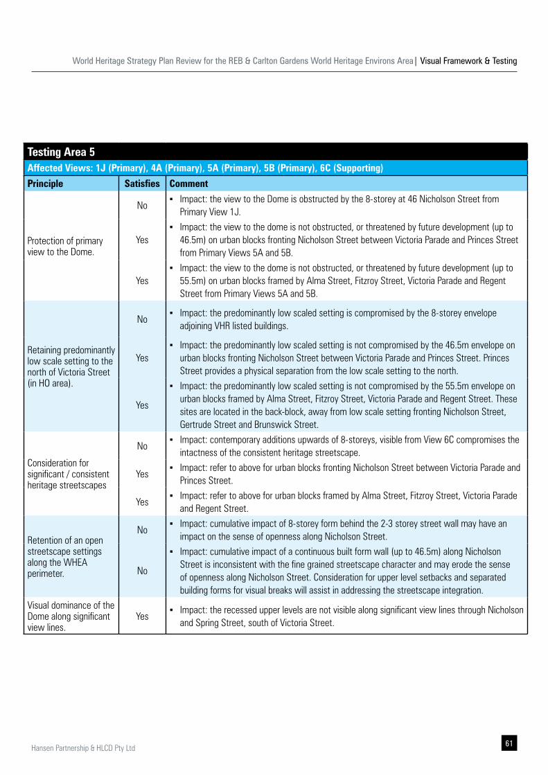
World Heritage Strategy Plan Review for the REB & Carlton Gardens World Heritage Environs Area| Visual Framework & Testing
61Hansen Partnership & HLCD Pty Ltd
Testing Area 5Affected Views: 1J (Primary), 4A (Primary), 5A (Primary), 5B (Primary), 6C (Supporting)
Principle Satisfies Comment
Protection of primary view to the Dome.
No ▪ Impact: the view to the Dome is obstructed by the 8-storey at 46 Nicholson Street from
Primary View 1J.
Yes ▪ Impact: the view to the dome is not obstructed, or threatened by future development (up to
46.5m) on urban blocks fronting Nicholson Street between Victoria Parade and Princes Street from Primary Views 5A and 5B.
Yes ▪ Impact: the view to the dome is not obstructed, or threatened by future development (up to
55.5m) on urban blocks framed by Alma Street, Fitzroy Street, Victoria Parade and Regent Street from Primary Views 5A and 5B.
Retaining predominantly low scale setting to the north of Victoria Street (in HO area).
No ▪ Impact: the predominantly low scaled setting is compromised by the 8-storey envelope
adjoining VHR listed buildings.
Yes ▪ Impact: the predominantly low scaled setting is not compromised by the 46.5m envelope on
urban blocks fronting Nicholson Street between Victoria Parade and Princes Street. Princes Street provides a physical separation from the low scale setting to the north.
Yes
▪ Impact: the predominantly low scaled setting is not compromised by the 55.5m envelope on urban blocks framed by Alma Street, Fitzroy Street, Victoria Parade and Regent Street. These sites are located in the back-block, away from low scale setting fronting Nicholson Street, Gertrude Street and Brunswick Street.
Consideration for significant / consistent heritage streetscapes
No ▪ Impact: contemporary additions upwards of 8-storeys, visible from View 6C compromises the
intactness of the consistent heritage streetscape.
Yes ▪ Impact: refer to above for urban blocks fronting Nicholson Street between Victoria Parade and
Princes Street.
Yes ▪ Impact: refer to above for urban blocks framed by Alma Street, Fitzroy Street, Victoria Parade
and Regent Street.
Retention of an open streetscape settings along the WHEA perimeter.
No ▪ Impact: cumulative impact of 8-storey form behind the 2-3 storey street wall may have an
impact on the sense of openness along Nicholson Street.
No
▪ Impact: cumulative impact of a continuous built form wall (up to 46.5m) along Nicholson Street is inconsistent with the fine grained streetscape character and may erode the sense of openness along Nicholson Street. Consideration for upper level setbacks and separated building forms for visual breaks will assist in addressing the streetscape integration.
Visual dominance of the Dome along significant view lines.
Yes ▪ Impact: the recessed upper levels are not visible along significant view lines through Nicholson
and Spring Street, south of Victoria Street.
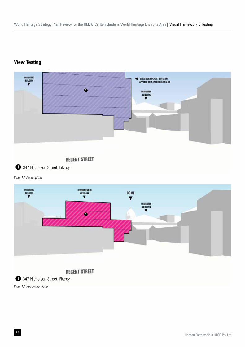
World Heritage Strategy Plan Review for the REB & Carlton Gardens World Heritage Environs Area| Visual Framework & Testing
62 Hansen Partnership & HLCD Pty Ltd
View Testing
View 1J: Assumption
View 1J: Recommendation
1
1
347 Nicholson Street, Fitzroy
347 Nicholson Street, Fitzroy
1
1
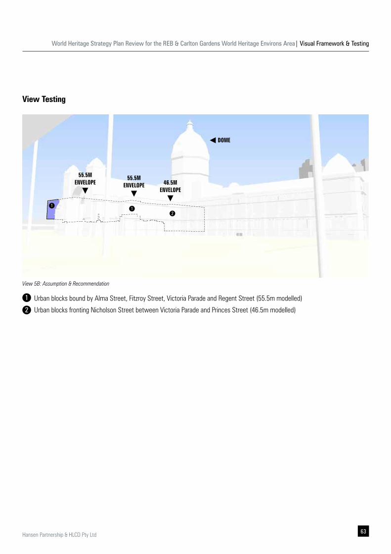
World Heritage Strategy Plan Review for the REB & Carlton Gardens World Heritage Environs Area| Visual Framework & Testing
63Hansen Partnership & HLCD Pty Ltd
DOME
55.5MENVELOPE
55.5MENVELOPE 46.5M
ENVELOPE
View 5B: Assumption & Recommendation
View Testing
11
2
Urban blocks bound by Alma Street, Fitzroy Street, Victoria Parade and Regent Street (55.5m modelled)
Urban blocks fronting Nicholson Street between Victoria Parade and Princes Street (46.5m modelled)
1
2
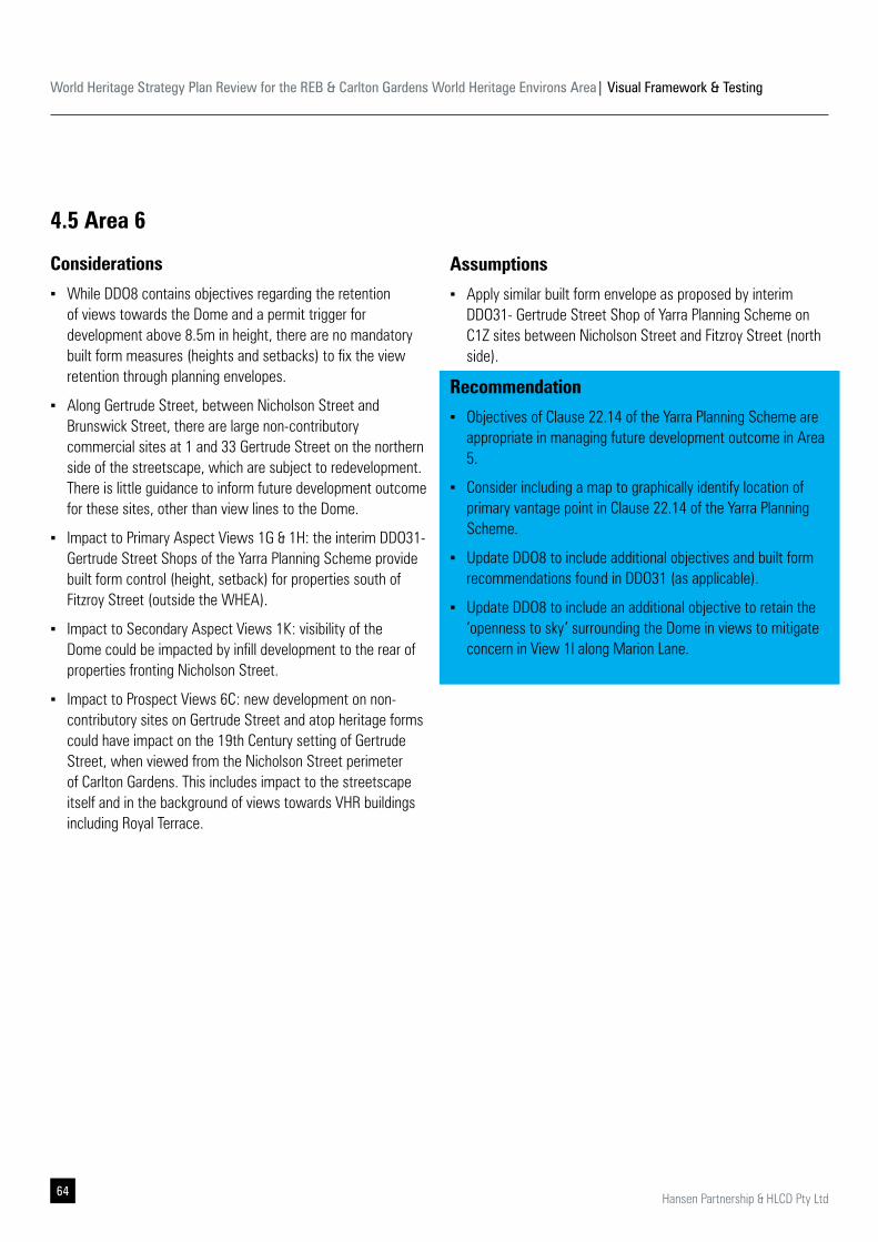
World Heritage Strategy Plan Review for the REB & Carlton Gardens World Heritage Environs Area| Visual Framework & Testing
64 Hansen Partnership & HLCD Pty Ltd
4.5 Area 6
Considerations
▪ While DDO8 contains objectives regarding the retention of views towards the Dome and a permit trigger for development above 8.5m in height, there are no mandatory built form measures (heights and setbacks) to fix the view retention through planning envelopes.
▪ Along Gertrude Street, between Nicholson Street and Brunswick Street, there are large non-contributory commercial sites at 1 and 33 Gertrude Street on the northern side of the streetscape, which are subject to redevelopment. There is little guidance to inform future development outcome for these sites, other than view lines to the Dome.
▪ Impact to Primary Aspect Views 1G & 1H: the interim DDO31- Gertrude Street Shops of the Yarra Planning Scheme provide built form control (height, setback) for properties south of Fitzroy Street (outside the WHEA).
▪ Impact to Secondary Aspect Views 1K: visibility of the Dome could be impacted by infill development to the rear of properties fronting Nicholson Street.
▪ Impact to Prospect Views 6C: new development on non-contributory sites on Gertrude Street and atop heritage forms could have impact on the 19th Century setting of Gertrude Street, when viewed from the Nicholson Street perimeter of Carlton Gardens. This includes impact to the streetscape itself and in the background of views towards VHR buildings including Royal Terrace.
Assumptions
▪ Apply similar built form envelope as proposed by interim DDO31- Gertrude Street Shop of Yarra Planning Scheme on C1Z sites between Nicholson Street and Fitzroy Street (north side).
Recommendation
▪ Objectives of Clause 22.14 of the Yarra Planning Scheme are appropriate in managing future development outcome in Area 5.
▪ Consider including a map to graphically identify location of primary vantage point in Clause 22.14 of the Yarra Planning Scheme.
▪ Update DDO8 to include additional objectives and built form recommendations found in DDO31 (as applicable).
▪ Update DDO8 to include an additional objective to retain the ‘openness to sky’ surrounding the Dome in views to mitigate concern in View 1I along Marion Lane.
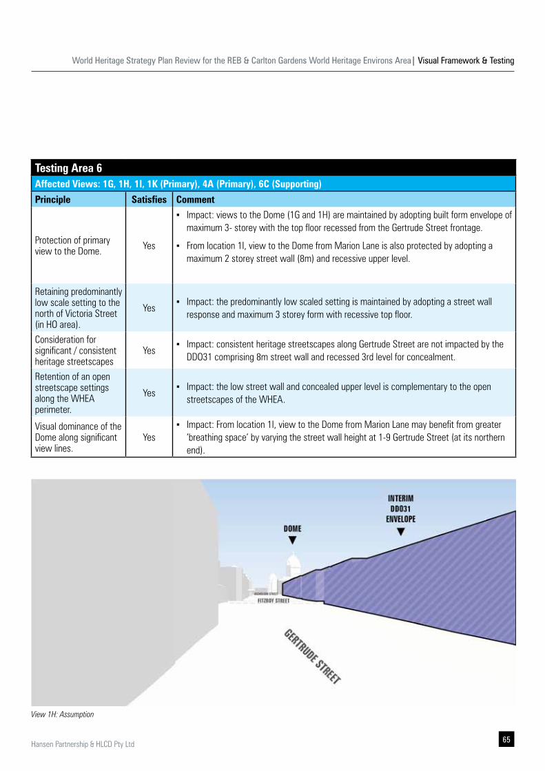
World Heritage Strategy Plan Review for the REB & Carlton Gardens World Heritage Environs Area| Visual Framework & Testing
65Hansen Partnership & HLCD Pty Ltd
Testing Area 6Affected Views: 1G, 1H, 1I, 1K (Primary), 4A (Primary), 6C (Supporting)
Principle Satisfies Comment
Protection of primary view to the Dome. Yes
▪ Impact: views to the Dome (1G and 1H) are maintained by adopting built form envelope of maximum 3- storey with the top floor recessed from the Gertrude Street frontage.
▪ From location 1I, view to the Dome from Marion Lane is also protected by adopting a maximum 2 storey street wall (8m) and recessive upper level.
Retaining predominantly low scale setting to the north of Victoria Street (in HO area).
Yes ▪ Impact: the predominantly low scaled setting is maintained by adopting a street wall
response and maximum 3 storey form with recessive top floor.
Consideration for significant / consistent heritage streetscapes
Yes ▪ Impact: consistent heritage streetscapes along Gertrude Street are not impacted by the
DDO31 comprising 8m street wall and recessed 3rd level for concealment.
Retention of an open streetscape settings along the WHEA perimeter.
Yes ▪ Impact: the low street wall and concealed upper level is complementary to the open
streetscapes of the WHEA.
Visual dominance of the Dome along significant view lines.
Yes ▪ Impact: From location 1I, view to the Dome from Marion Lane may benefit from greater
‘breathing space’ by varying the street wall height at 1-9 Gertrude Street (at its northern end).
View 1H: Assumption
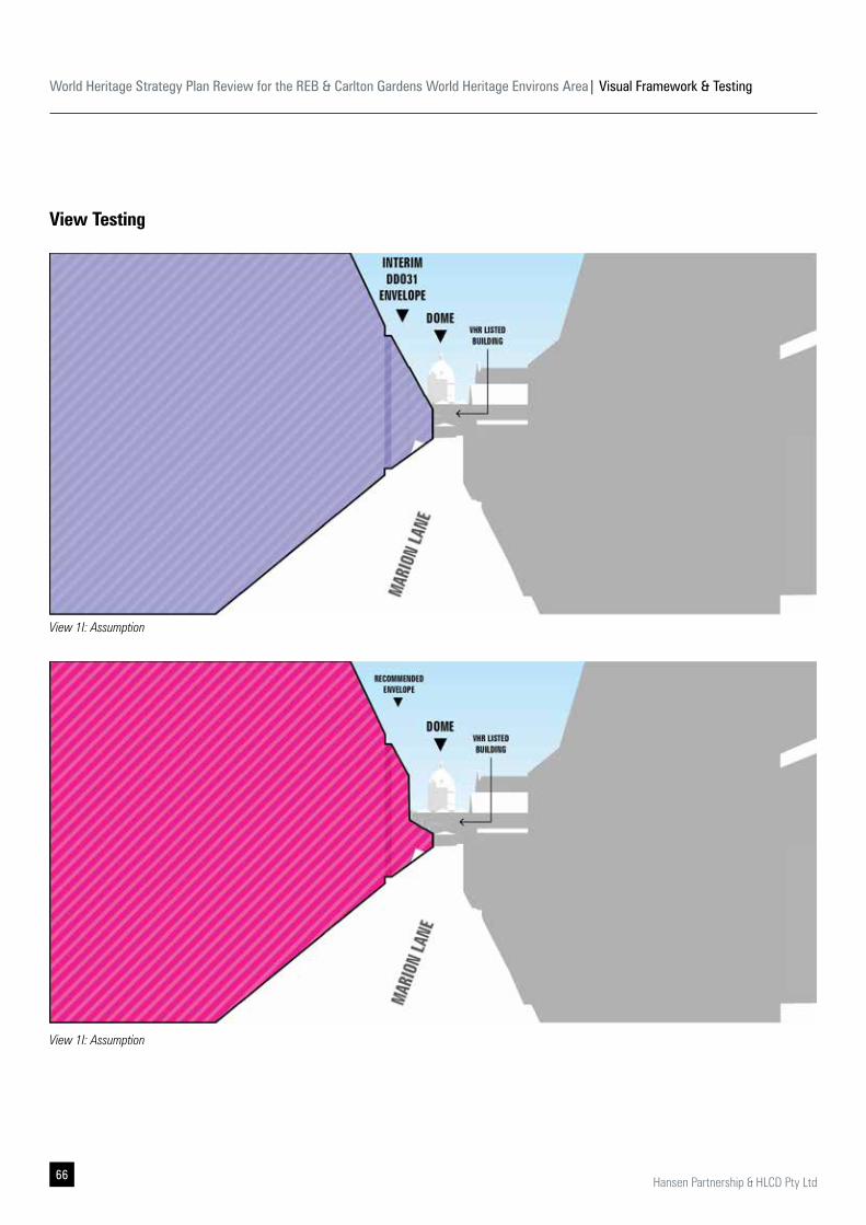
World Heritage Strategy Plan Review for the REB & Carlton Gardens World Heritage Environs Area| Visual Framework & Testing
66 Hansen Partnership & HLCD Pty Ltd
View Testing
View 1I: Assumption
View 1I: Assumption

World Heritage Strategy Plan Review for the REB & Carlton Gardens World Heritage Environs Area| Visual Framework & Testing
67Hansen Partnership & HLCD Pty Ltd
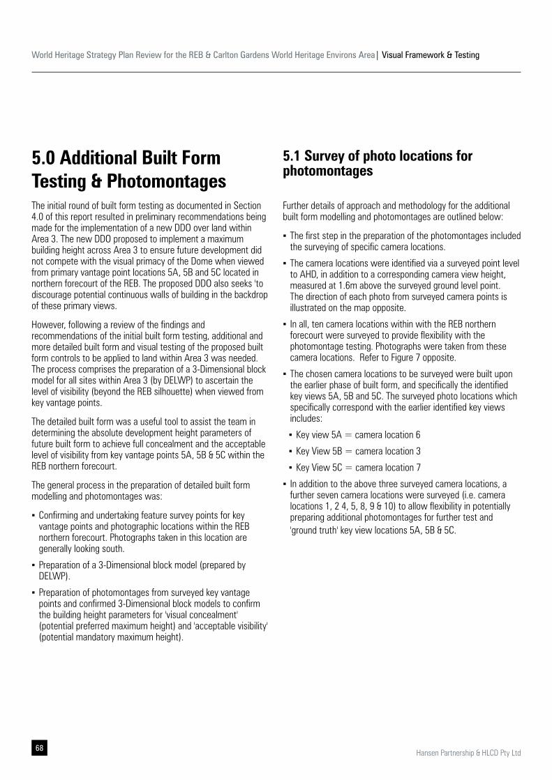
World Heritage Strategy Plan Review for the REB & Carlton Gardens World Heritage Environs Area| Visual Framework & Testing
68 Hansen Partnership & HLCD Pty Ltd
5.0 Additional Built Form Testing & PhotomontagesThe initial round of built form testing as documented in Section 4.0 of this report resulted in preliminary recommendations being made for the implementation of a new DDO over land within Area 3. The new DDO proposed to implement a maximum building height across Area 3 to ensure future development did not compete with the visual primacy of the Dome when viewed from primary vantage point locations 5A, 5B and 5C located in northern forecourt of the REB. The proposed DDO also seeks 'to discourage potential continuous walls of building in the backdrop of these primary views.
However, following a review of the findings and recommendations of the initial built form testing, additional and more detailed built form and visual testing of the proposed built form controls to be applied to land within Area 3 was needed. The process comprises the preparation of a 3-Dimensional block model for all sites within Area 3 (by DELWP) to ascertain the level of visibility (beyond the REB silhouette) when viewed from key vantage points.
The detailed built form was a useful tool to assist the team in determining the absolute development height parameters of future built form to achieve full concealment and the acceptable level of visibility from key vantage points 5A, 5B & 5C within the REB northern forecourt.
The general process in the preparation of detailed built form modelling and photomontages was:
▪ Confirming and undertaking feature survey points for key vantage points and photographic locations within the REB northern forecourt. Photographs taken in this location are generally looking south.
▪ Preparation of a 3-Dimensional block model (prepared by DELWP).
▪ Preparation of photomontages from surveyed key vantage points and confirmed 3-Dimensional block models to confirm the building height parameters for 'visual concealment' (potential preferred maximum height) and 'acceptable visibility' (potential mandatory maximum height).
5.1 Survey of photo locations for photomontages
Further details of approach and methodology for the additional built form modelling and photomontages are outlined below:
▪ The first step in the preparation of the photomontages included the surveying of specific camera locations.
▪ The camera locations were identified via a surveyed point level to AHD, in addition to a corresponding camera view height, measured at 1.6m above the surveyed ground level point. The direction of each photo from surveyed camera points is illustrated on the map opposite.
▪ In all, ten camera locations within with the REB northern forecourt were surveyed to provide flexibility with the photomontage testing. Photographs were taken from these camera locations. Refer to Figure 7 opposite.
▪ The chosen camera locations to be surveyed were built upon the earlier phase of built form, and specifically the identified key views 5A, 5B and 5C. The surveyed photo locations which specifically correspond with the earlier identified key views includes:
▪ Key view 5A = camera location 6
▪ Key View 5B = camera location 3
▪ Key View 5C = camera location 7
▪ In addition to the above three surveyed camera locations, a further seven camera locations were surveyed (i.e. camera locations 1, 2 4, 5, 8, 9 & 10) to allow flexibility in potentially preparing additional photomontages for further test and 'ground truth' key view locations 5A, 5B & 5C.
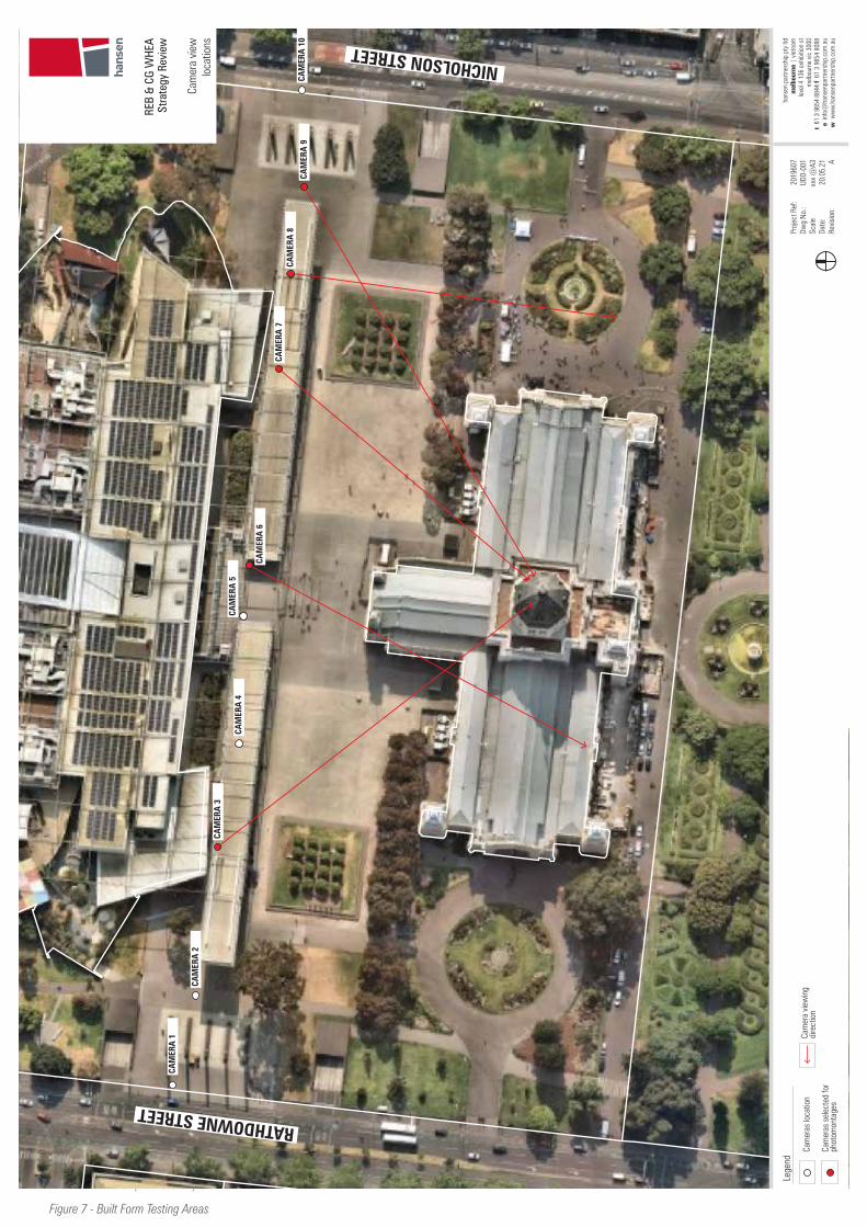
World Heritage Strategy Plan Review for the REB & Carlton Gardens World Heritage Environs Area| Visual Framework & Testing
69Hansen Partnership & HLCD Pty Ltd
CAM
ERA
1
CAM
ERA
2
CAM
ERA
3
CAM
ERA
4CA
MER
A 5
CAM
ERA
7CA
MER
A 8
CAM
ERA
9CA
MER
A 1
0
CAM
ERA
6
RATHDOWNE STREET
NICHOLSON STREET
Proj
ect R
ef:
Dw
g No
.:Sc
ale
Date
:Re
visio
n:
2019
607
UDD-
001
xxx
@A3
20.0
5.21 A
hans
en p
artn
ersh
ip p
ty lt
dm
elbo
urne
| v
ietn
am
leve
l 4 1
36 e
xhib
ition
st
mel
bour
ne v
ic 3
000
t 61
3 9
654
8844
f 6
1 3
9654
808
8 e
inf
o@ha
nsen
partn
ersh
ip.c
om.a
uw
ww
w.h
anse
npar
tner
ship
.com
.au
REB
& CG
WHE
A St
rate
gy R
evie
w
Cam
era
view
lo
catio
ns
Lege
nd
Cam
eras
loca
tion
Cam
era
view
ing
dire
ctio
nCa
mer
as s
elec
ted
for
phot
omon
tage
s
Figure 7 - Built Form Testing Areas
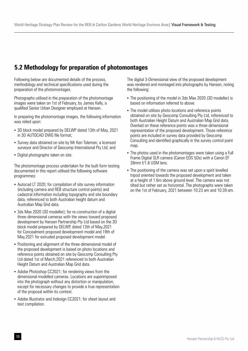
World Heritage Strategy Plan Review for the REB & Carlton Gardens World Heritage Environs Area| Visual Framework & Testing
70 Hansen Partnership & HLCD Pty Ltd
5.2 Methodology for preparation of photomontages
Following below are documented details of the process, methodology and technical specifications used during the preparation of the photomontages.
Photographs utilised in the preparation of the photomontage images were taken on 1st of February, by James Kelly, a qualified Senior Urban Designer employed at Hansen.
In preparing the photomontage images, the following information was relied upon:
▪ 3D block model prepared by DELWP dated 13th of May, 2021 in 3D AUTOCAD DWG file format;
▪ Survey data obtained on site by Mr Ken Toleman, a licensed surveyor and Director of Geocomp International Pty Ltd; and
▪ Digital photographs taken on site.
The photomontage process undertaken for the built form testing documented in this report utilised the following software programmes:
▪ Autocad LT 2020; for compilation of site survey information (including camera and REB structure control points) and cadastral information including topography and site boundary data, referenced to both Australian height datum and Australian Map Grid data.
▪ 3ds Max 2020 (3D modeller); for re-construction of a digital three-dimensional cameras with the views toward proposed development by Hansen Partnership Pty Ltd based on the 3D block model prepared by DELWP, dated 13th of May,2021 for Concealment proposed development model and 19th of May,2021 for extruded proposed development model.
▪ Positioning and alignment of the three-dimensional model of the proposed development is based on photo locations and reference points obtained on site by Geocomp Consulting Pty Ltd dated 1st of March,2021 referenced to both Australian Height Datum and Australian Map Grid data.
▪ Adobe Photoshop CC2021; for rendering views from the dimensional modelled cameras. Locations are superimposed into the photograph without any distortion or manipulation, except for necessary changes to provide a true representation of the proposal within its context.
▪ Adobe Illustrator and Indesign CC2021; for sheet layout and text compilation.
The digital 3-Dimensional view of the proposed development was rendered and montaged into photographs by Hansen, noting the following:
▪ The positioning of the model in 3ds Max 2020 (3D modeller) is based on information referred to above.
▪ The model utilises photo locations and reference points obtained on site by Geocomp Consulting Pty Ltd, referenced to both Australian Height Datum and Australian Map Grid data. Overlaid on these reference points was a three-dimensional representation of the proposed development. Those reference points are included in survey data provided by Geocomp Consulting and identified graphically in the survey control point map.
▪ The photos used in the photomontages were taken using a Full Frame Digital SLR camera (Canon EOS 5Ds) with a Canon EF 28mm f/1.8 USM lens.
▪ The positioning of the camera was set upon a spirit levelled tripod oriented towards the proposed development and taken at a height of 1.6m above ground level. The camera was not tilted but rather set as horizontal. The photographs were taken on the 1st of February, 2021 between 10:23 am and 10:39 am.
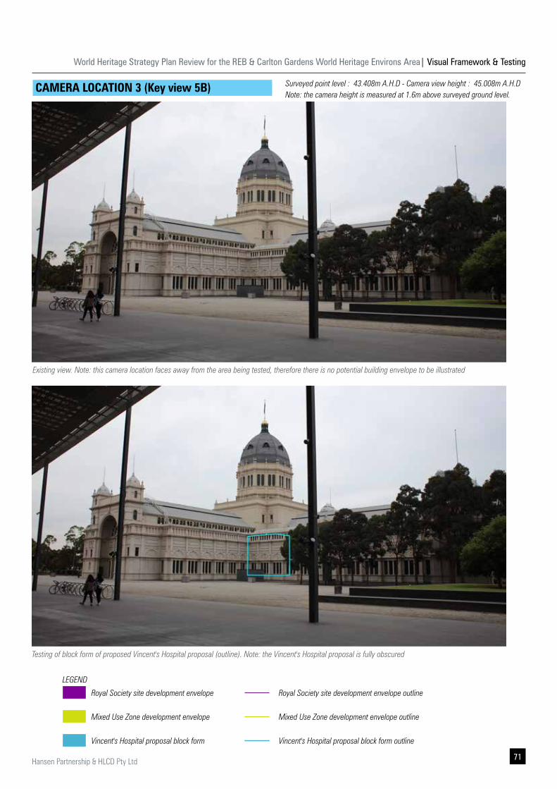
World Heritage Strategy Plan Review for the REB & Carlton Gardens World Heritage Environs Area| Visual Framework & Testing
71Hansen Partnership & HLCD Pty Ltd
Existing view. Note: this camera location faces away from the area being tested, therefore there is no potential building envelope to be illustrated
CAMERA LOCATION 3 (Key view 5B)
Testing of block form of proposed Vincent's Hospital proposal (outline). Note: the Vincent's Hospital proposal is fully obscured
Surveyed point level : 43.408m A.H.D - Camera view height : 45.008m A.H.D Note: the camera height is measured at 1.6m above surveyed ground level.
Royal Society site development envelope
Mixed Use Zone development envelope
Vincent's Hospital proposal block form
LEGEND
Royal Society site development envelope outline
Mixed Use Zone development envelope outline
Vincent's Hospital proposal block form outline
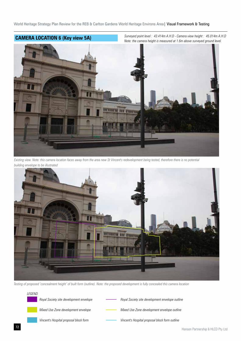
World Heritage Strategy Plan Review for the REB & Carlton Gardens World Heritage Environs Area| Visual Framework & Testing
72 Hansen Partnership & HLCD Pty Ltd
Existing view. Note: this camera location faces away from the area new St Vincent's redevelopment being tested, therefore there is no potential building envelope to be illustrated
CAMERA LOCATION 6 (Key view 5A)
Testing of proposed ‘concealment height’ of built form (outline). Note: the proposed development is fully concealed this camera location
Royal Society site development envelope
Mixed Use Zone development envelope
Vincent's Hospital proposal block form
LEGEND
Royal Society site development envelope outline
Mixed Use Zone development envelope outline
Vincent's Hospital proposal block form outline
Surveyed point level : 43.414m A.H.D - Camera view height : 45.014m A.H.D Note: the camera height is measured at 1.6m above surveyed ground level.
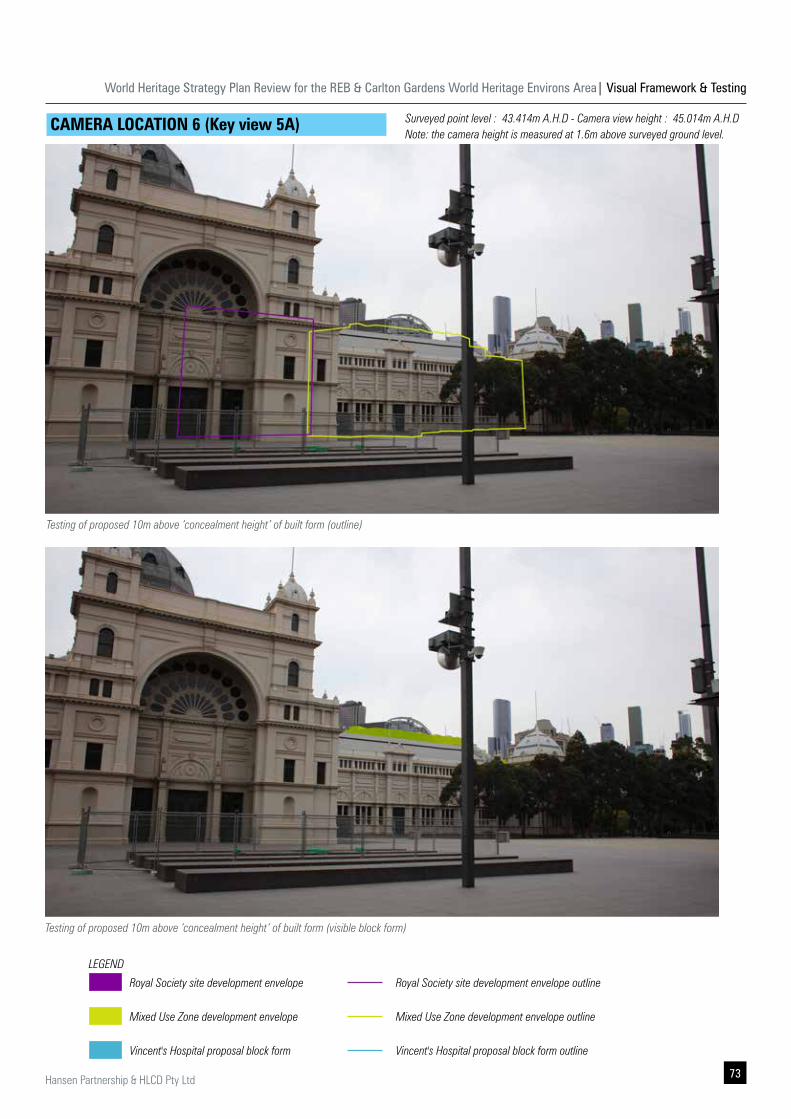
World Heritage Strategy Plan Review for the REB & Carlton Gardens World Heritage Environs Area| Visual Framework & Testing
73Hansen Partnership & HLCD Pty Ltd
Testing of proposed 10m above ‘concealment height’ of built form (outline)
CAMERA LOCATION 6 (Key view 5A)
Testing of proposed 10m above ‘concealment height’ of built form (visible block form)
Royal Society site development envelope
Mixed Use Zone development envelope
Vincent's Hospital proposal block form
LEGEND
Royal Society site development envelope outline
Mixed Use Zone development envelope outline
Vincent's Hospital proposal block form outline
Surveyed point level : 43.414m A.H.D - Camera view height : 45.014m A.H.D Note: the camera height is measured at 1.6m above surveyed ground level.
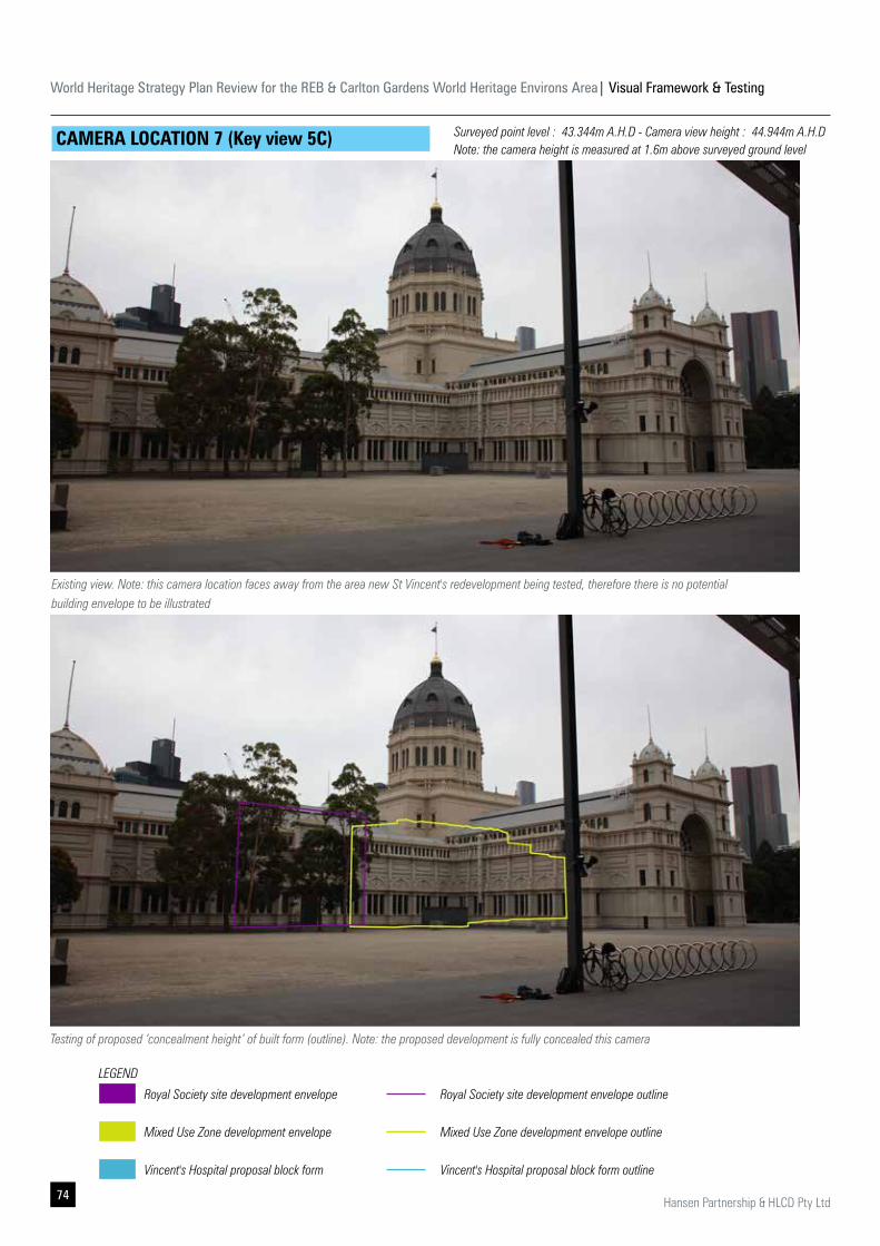
World Heritage Strategy Plan Review for the REB & Carlton Gardens World Heritage Environs Area| Visual Framework & Testing
74 Hansen Partnership & HLCD Pty Ltd
CAMERA LOCATION 7 (Key view 5C)
Testing of proposed ‘concealment height’ of built form (outline). Note: the proposed development is fully concealed this camera
Existing view. Note: this camera location faces away from the area new St Vincent's redevelopment being tested, therefore there is no potential building envelope to be illustrated
Royal Society site development envelope
Mixed Use Zone development envelope
Vincent's Hospital proposal block form
LEGEND
Royal Society site development envelope outline
Mixed Use Zone development envelope outline
Vincent's Hospital proposal block form outline
Surveyed point level : 43.344m A.H.D - Camera view height : 44.944m A.H.D Note: the camera height is measured at 1.6m above surveyed ground level
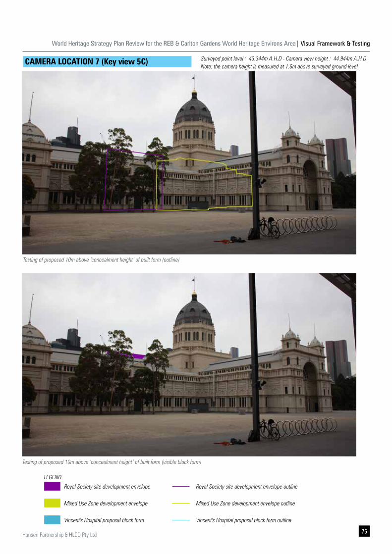
World Heritage Strategy Plan Review for the REB & Carlton Gardens World Heritage Environs Area| Visual Framework & Testing
75Hansen Partnership & HLCD Pty Ltd
CAMERA LOCATION 7 (Key view 5C)
Testing of proposed 10m above ‘concealment height’ of built form (visible block form)
Testing of proposed 10m above ‘concealment height’ of built form (outline)
Royal Society site development envelope
Mixed Use Zone development envelope
Vincent's Hospital proposal block form
LEGEND
Royal Society site development envelope outline
Mixed Use Zone development envelope outline
Vincent's Hospital proposal block form outline
Surveyed point level : 43.344m A.H.D - Camera view height : 44.944m A.H.D Note: the camera height is measured at 1.6m above surveyed ground level.

World Heritage Strategy Plan Review for the REB & Carlton Gardens World Heritage Environs Area| Visual Framework & Testing
76 Hansen Partnership & HLCD Pty Ltd
CAMERA LOCATION 8
Testing of proposed ‘concealment height’ of built form (outline). Note: the proposed development is fully concealed this camera location
Existing view
Royal Society site development envelope
Mixed Use Zone development envelope
Vincent's Hospital proposal block form
LEGEND
Royal Society site development envelope outline
Mixed Use Zone development envelope outline
Vincent's Hospital proposal block form outline
Surveyed point level : 43.345m A.H.D - Camera view height : 44.945m A.H.D Note: the camera height is measured at 1.6m above surveyed ground level.

World Heritage Strategy Plan Review for the REB & Carlton Gardens World Heritage Environs Area| Visual Framework & Testing
77Hansen Partnership & HLCD Pty Ltd
CAMERA LOCATION 8
Testing of proposed 10m above ‘concealment height’ of built form (visible block form)
Testing of proposed 10m above ‘concealment height’ of built form (outline)
Royal Society site development envelope
Mixed Use Zone development envelope
Vincent's Hospital proposal block form
LEGEND
Royal Society site development envelope outline
Mixed Use Zone development envelope outline
Vincent's Hospital proposal block form outline
Surveyed point level : 43.345m A.H.D - Camera view height : 44.945m A.H.D Note: the camera height is measured at 1.6m above surveyed ground level.
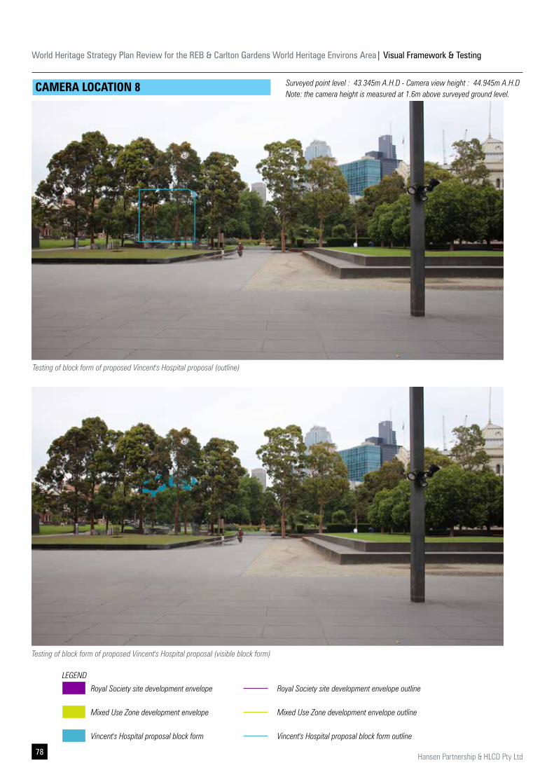
World Heritage Strategy Plan Review for the REB & Carlton Gardens World Heritage Environs Area| Visual Framework & Testing
78 Hansen Partnership & HLCD Pty Ltd
CAMERA LOCATION 8
Testing of block form of proposed Vincent's Hospital proposal (visible block form)
Testing of block form of proposed Vincent's Hospital proposal (outline)
Royal Society site development envelope
Mixed Use Zone development envelope
Vincent's Hospital proposal block form
LEGEND
Royal Society site development envelope outline
Mixed Use Zone development envelope outline
Vincent's Hospital proposal block form outline
Surveyed point level : 43.345m A.H.D - Camera view height : 44.945m A.H.D Note: the camera height is measured at 1.6m above surveyed ground level.
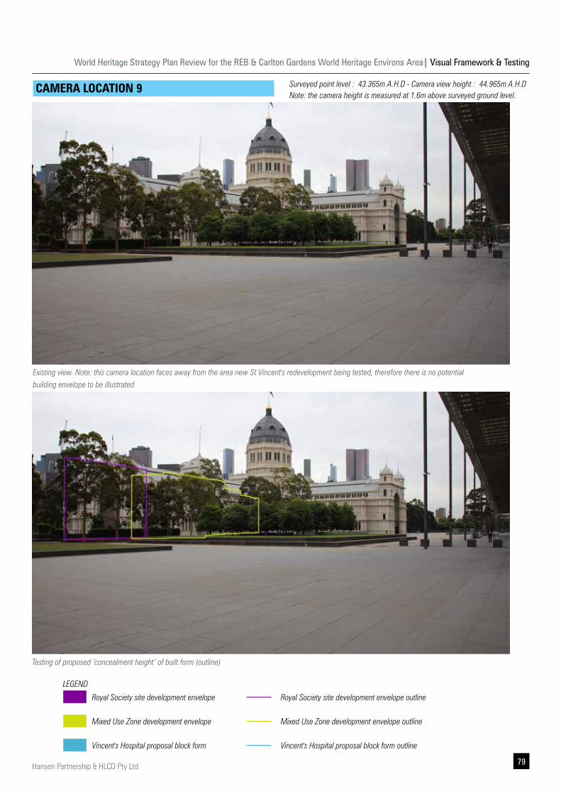
World Heritage Strategy Plan Review for the REB & Carlton Gardens World Heritage Environs Area| Visual Framework & Testing
79Hansen Partnership & HLCD Pty Ltd
CAMERA LOCATION 9
Testing of proposed ‘concealment height’ of built form (outline)
Existing view. Note: this camera location faces away from the area new St Vincent's redevelopment being tested, therefore there is no potential building envelope to be illustrated
Royal Society site development envelope
Mixed Use Zone development envelope
Vincent's Hospital proposal block form
LEGEND
Royal Society site development envelope outline
Mixed Use Zone development envelope outline
Vincent's Hospital proposal block form outline
Surveyed point level : 43.365m A.H.D - Camera view height : 44.965m A.H.D Note: the camera height is measured at 1.6m above surveyed ground level.
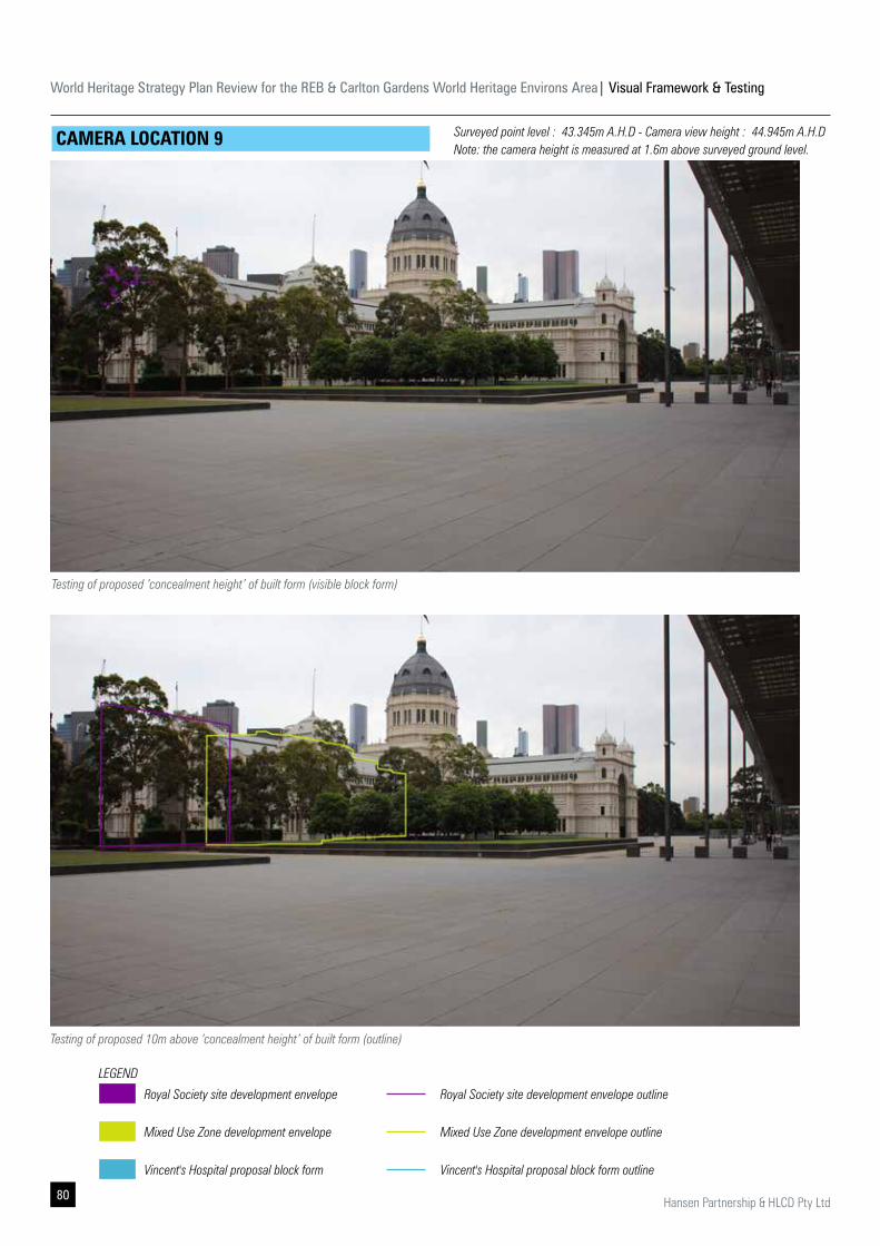
World Heritage Strategy Plan Review for the REB & Carlton Gardens World Heritage Environs Area| Visual Framework & Testing
80 Hansen Partnership & HLCD Pty Ltd
CAMERA LOCATION 9
Testing of proposed 10m above ‘concealment height’ of built form (outline)
Testing of proposed ‘concealment height’ of built form (visible block form)
Royal Society site development envelope
Mixed Use Zone development envelope
Vincent's Hospital proposal block form
LEGEND
Royal Society site development envelope outline
Mixed Use Zone development envelope outline
Vincent's Hospital proposal block form outline
Surveyed point level : 43.345m A.H.D - Camera view height : 44.945m A.H.D Note: the camera height is measured at 1.6m above surveyed ground level.
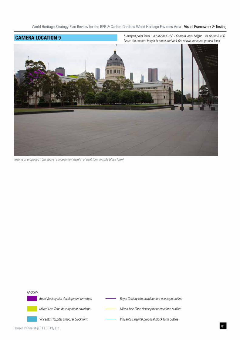
World Heritage Strategy Plan Review for the REB & Carlton Gardens World Heritage Environs Area| Visual Framework & Testing
81Hansen Partnership & HLCD Pty Ltd
CAMERA LOCATION 9
Testing of proposed 10m above ‘concealment height’ of built form (visible block form)
Royal Society site development envelope
Mixed Use Zone development envelope
Vincent's Hospital proposal block form
LEGEND
Royal Society site development envelope outline
Mixed Use Zone development envelope outline
Vincent's Hospital proposal block form outline
Surveyed point level : 43.365m A.H.D - Camera view height : 44.965m A.H.D Note: the camera height is measured at 1.6m above surveyed ground level.
World Heritage Strategy Plan Review for the REB & Carlton Gardens World Heritage Environs Area| Visual Framework & Testing
82 Hansen Partnership & HLCD Pty Ltd
The clear benefit of undertaking additional built from testing through the use of a 3-Dimensional block model (by DELWP) and the preparation of photomontages, was the ability to inform potential future built form parameters within Area 3 (i.e. on a site by site basis) to achieve partial, or full visual concealment from key views 5A and 5C.
The additional built form testing was able to establish and confirm the maximum building heights on a site by site basis for full concealment when viewed from identified key views 5A and 5C (as well as and secondary camera locations).
The additional built form testing was also able to establish an appropriate scale of built form above 'the full concealment height' which although would be visible from identified key views 5A and 5C (and secondary camera locations), would not overly dominate the primacy of the view of the northern elevation of the REB.
Through a process of workshop testing and discussions with DELWP, the appropriate 'visibility height' was determined to be 10m above the tested and confirmed 'concealment height'. This then allowed the potential consideration of a building rising to a maximum height of 10m above 'concealment height' on a site by site basis, which was confirmed when viewed from identified key views 5A and 5C (as well as and secondary camera locations).
The conducted built form testing functions to provide a documented evidence base for the confirmed building heights to be implemented through a DDO to be prepared for MUZ land within Area 3, and with the intention to implement built form controls to a preferred maximum building height (i.e. concealment height), and a mandatory maximum building height (i.e. 10m above concealment height).
5.2 Conclusions on additional built form testing
However, an additional recommendation is for a new DDO to be prepared to include a series of suitable objectives to ensure that any proposed future building which exceeds the preferred maximum building height (i.e. concealment height) does not potentially create a continuous wall of building as a backdrop of the REB silhouette from key vantage points. The recommended objectives address the following:
▪ An application to exceed the preferred maximum building height must meet the following design objectives to the satisfaction of the responsible authority, and demonstrate that the proposed building when viewed from the Melbourne Museum Forecourt (and particularly view locations 5A and 5C):
▪ Does not impact or overwhelm the visual dominance of the drum, dome, lantern and northern elevation of the Royal Exhibition Building;
▪ Ensures building design, setback and orientation does not overwhelm the northern elevation of the Royal Exhibition Building, by creating a solid horizontal ‘wall’ of built form silhouetting the ridgeline;
▪ Ensures materiality which is influenced by its heritage setting and is of muted materials and colours, and which avoids the use of larger areas of reflective materials.
▪ Ensures visibility of building services and plant equipment and plant is minimised and/or screened within of the maximum building height.
Also of note, during the additional testing process, potential built form scale on The Royal Society of Victoria site at 8 La Trobe Street was undertaken. However it was determined that such testing would not need to be potentially translated into a DDO, as other factors such as the site being included in the Victorian Heritage Register will play a much greater role in determining any potential future built form and development scale on this site.
Lastly, as the photomontages were prepared after a planning application for the Vincent's Hospital redevelopment had been lodged with Yarra City Council for consideration, the opportunity was taken to test and analyse the proposed built form scale from key and secondary vantage points from the REB northern forecourt. The outcomes of this visual built form testing is documented through the images within this report section.
World Heritage Strategy Plan Review for the REB & Carlton Gardens World Heritage Environs Area| Visual Framework & Testing
83Hansen Partnership & HLCD Pty Ltd
6.0 Summary of Recommendations
Following below is a summary of recommendations relating to each of the six areas subject to built form testing as outlined in Section 4.0 and Section 5.0. The summary recommendations are further categorised by the municipal areas of the City of Melbourne and City of Yarra. These are also summarised in Figure 07 on Page 68.
City of Melbourne - Area 1 & Area 2 City of Melbourne - Area 3Clause 22.21
▪ Objectives of Clause 22.21 of the Melbourne Planning Scheme are appropriate in managing future development outcome in Area 1 and Area 2.
▪ Recommend including a map to graphically identify location of primary vantage point in Clause 22.21 of the Melbourne Planning Scheme.
▪ Recommend amending Clause 22.21 to include provisions to address the protection of primary view lines, which includes:
▪ View 1A: View towards the Dome from the southern footpath of Queensberry Street, at the south eastern junction with Drummond Street.
▪ View 1B: View towards the Dome from the southern footpath of Queensberry Street, at the south eastern junction of Lygon Street (outside WHEA boundary).
▪ View 3A: View towards the REB, Dome and Carlton Gardens from the western footpath of Rathdowne Street, at the north western junction with Pelham Street.
▪ View 3B: View towards the REB, Dome and Carlton Gardens from the eastern footpath of Rathdowne Street, between 101 & 117 Rathdowne Street (pedestrian crossing).
▪ Recommend western expansion of the WHEA boundary to include properties on the west side of Drummond Street (currently in DDO6) in response to the 19th century setting.
DDO6 ▪ Objectives and requirements found in DDO6 are appropriate in managing future development outcome on the west side of Rathdowne Street. Continue to apply DDO6 for Area 1 and Area 2 currently in DDO6.
▪ Objectives and requirements found in DDO6 are appropriate in managing future development outcome on the west side of Rathdowne Street currently not in DDO6.
▪ Recommend extending DDO6-10, DDO6-12, DDO6-13 and DDO6-14 to include 110 to 150 Drummond Street, 15-31 Pelham Street, 107 to 161 Rathdowne Street to fill existing gap and ensure there is clear built form guidance for future redevelopment of these sites. Refer to Figure 7 on Page 68.
Clause 22.21
▪ Objectives of Clause 22.21 of the Melbourne Planning Scheme are appropriate in managing future development outcome in Area 3 (east of Exhibition Street).
▪ Recommend including a map to graphically identify location of primary vantage point in Clause 22.21 of the Melbourne Planning Scheme.
▪ Recommend amending Clause 22.21 to include provisions to address the protection of primary view lines, which includes:
▪ View 5A: View towards the Dome and REB northern elevation from the Melbourne Museum Forecourt (Central Entry).
▪ View 5B: View towards the Dome and REB northern elevation from the Melbourne Museum Forecourt (Western Entry).
▪ View 5C: View towards the Dome and REB northern elevation from the Melbourne Museum Forecourt (Eastern Entry/ Lift).
New DDO
▪ Recommend western expansion of the WHEA boundary and introduction of a new DDO for Area 3 (west of Exhibition Street) to provide clear objectives and built form parameters to assess future development applications in relation to protecting primary views and visual dominance of the Dome from location 5A and 5C.
▪ Recommend a new DDO for MUZ land within Area 3 west of Exhibition Street, to nominate a preferred maximum and mandatory maximum building heights on a site by site basis as determined by the detailed built form modelling. Include a series of objectives to apply to proposed future building which exceeds the preferred maximum building height (i.e. concealment height) to ensure it does not compete with or potentially create a continuous wall of building as a backdrop of the REB silhouette from key vantage points.
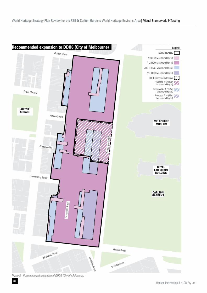
World Heritage Strategy Plan Review for the REB & Carlton Gardens World Heritage Environs Area| Visual Framework & Testing
84 Hansen Partnership & HLCD Pty Ltd
DDO6 Proposed Extension
DDO6 Boundary
Legend
A12 (10m Maximum Height)
A10 (8m Maximum Height)
A13 (13.5m Maximum Height)
A14 (16m Maximum Height)
Proposed A12 (10m Maximum Height)
Proposed A13 (13.5m Maximum Height)
Proposed A14 (16m Maximum Height)
Rath
dow
ne S
treet
Drum
mon
d St
reet
Grattan Street
Pelham Street
Queensberry Street
Argyle Place N
Drummond Pl
ARGYLE SQUARE
Victoria Street
McKenzie Street
La Trobe Street
Exhibition Street
CARLTONGARDENS
MELBOURNEMUSEUM
ROYAL EXHIBITION BUILDING
Figure 8 - Recommended expansion of DDO6 (City of Melbourne)
Recommended expansion to DDO6 (City of Melbourne)
World Heritage Strategy Plan Review for the REB & Carlton Gardens World Heritage Environs Area| Visual Framework & Testing
85Hansen Partnership & HLCD Pty Ltd
Clause 22.14
▪ Objectives of Clause 22.14 of the Yarra Planning Scheme are appropriate in managing future development outcome in Area 5.
▪ Recommend including a map to graphically identify location of primary vantage point in Clause 22.14 of the Yarra Planning Scheme.
▪ Recommend amending Clause 22.21 to include provisions to address the protection of primary view lines, which includes:
▪ View 1G: View of the Dome from the southern footpath of Gertrude Street, north western corner of Fitzroy Street junction.
▪ View 1H: View of the Dome from the from southern footpath of Gertrude Street, north western corner of Brunswick Street junction (outside WHEA).
▪ View 1J: View of the Dome from the from eastern footpath of Regent Street, north eastern corner of Alma Street junction.
New DDO
▪ Recommend introducing a new Design and Development Overlays to cover C1Z sites in Area 5 to provide clear objectives and built form parameters to assess future development applications in relation to protecting primary views and visual dominance of the Dome from location 1J. Refer to recommendations for Area 6 as an alternative option.
▪ Recommend replicating the objectives of DDO6, or DDO13 of Melbourne Planning Scheme future DDO objectives for Area 5.
▪ Recommend implementing maximum building heights (through a new DDO) in Area 5 as follows:
▪ A maximum building height of 13.5m - matching maximum building height at 46 Nicholson Street.
▪ Adopt side setbacks (above 2 storeys) to retain primary view to the Dome from Location 1J.
▪ Adopt a street wall response that is informed by adjoining heritage buildings.
City of Melbourne - Area 4 City of Yarra - Area 5
Clause 22.21
▪ Objectives of Clause 22.21 of the Melbourne Planning Scheme are appropriate in managing future development outcome in Area 4.
▪ Recommend including a map to graphically identify location of primary vantage point in Clause 22.21 of the Melbourne Planning Scheme.
▪ Recommend amending Clause 22.21 to include provisions to address the protection of primary view lines, which includes:
▪ View 1C: View towards the Dome from the western footpath of Spring Street, north west corner of Lonsdale Street junction.
▪ View 1D: View towards the Dome from the western footpath of Spring Street, south west corner of Bourke Street junction.
▪ View 1E: View towards the Dome from the eastern footpath of Nicholson Street, south of Evelyn Place.
▪ View 1F: View towards the Dome from the eastern footpath of Victoria Parade central median and Tram Stop.
DDO13
▪ Objectives and requirements found in DDO13 are appropriate in managing future development outcome on the west side of Rathdowne Street. Continue applying the DDO13-A26 with further recommended refinements, including:
▪ Update Table to Schedule 13 Outcomes for area 26 to: protect views of the Drum, Dome, Lantern and Flagpole of the REB at north west corner of Lonsdale Street; and the north eastern corner of Nicholson St and Evelyn Place.
▪ Add an outcome to retain ‘clear sky view’ to the Drum, Dome, Lantern and Flagpole of the REB from the nominated primary vantage points.
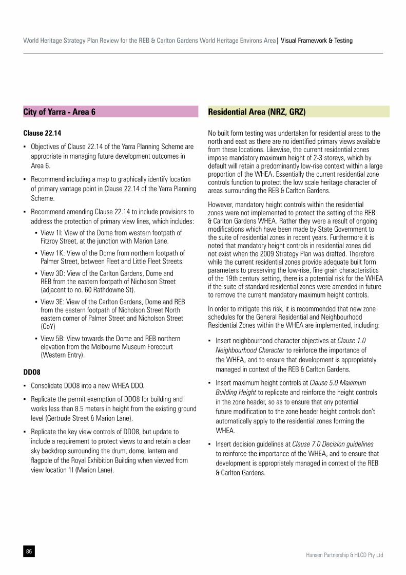
World Heritage Strategy Plan Review for the REB & Carlton Gardens World Heritage Environs Area| Visual Framework & Testing
86 Hansen Partnership & HLCD Pty Ltd
Clause 22.14
▪ Objectives of Clause 22.14 of the Yarra Planning Scheme are appropriate in managing future development outcomes in Area 6.
▪ Recommend including a map to graphically identify location of primary vantage point in Clause 22.14 of the Yarra Planning Scheme.
▪ Recommend amending Clause 22.14 to include provisions to address the protection of primary view lines, which includes:
▪ View 1I: View of the Dome from western footpath of Fitzroy Street, at the junction with Marion Lane.
▪ View 1K: View of the Dome from northern footpath of Palmer Street, between Fleet and Little Fleet Streets.
▪ View 3D: View of the Carlton Gardens, Dome and REB from the eastern footpath of Nicholson Street (adjacent to no. 60 Rathdowne St).
▪ View 3E: View of the Carlton Gardens, Dome and REB from the eastern footpath of Nicholson Street North eastern corner of Palmer Street and Nicholson Street (CoY)
▪ View 5B: View towards the Dome and REB northern elevation from the Melbourne Museum Forecourt (Western Entry).
DDO8
▪ Consolidate DDO8 into a new WHEA DDO.
▪ Replicate the permit exemption of DDO8 for building and works less than 8.5 meters in height from the existing ground level (Gertrude Street & Marion Lane).
▪ Replicate the key view controls of DDO8, but update to include a requirement to protect views to and retain a clear sky backdrop surrounding the drum, dome, lantern and flagpole of the Royal Exhibition Building when viewed from view location 1I (Marion Lane).
No built form testing was undertaken for residential areas to the north and east as there are no identified primary views available from these locations. Likewise, the current residential zones impose mandatory maximum height of 2-3 storeys, which by default will retain a predominantly low-rise context within a large proportion of the WHEA. Essentially the current residential zone controls function to protect the low scale heritage character of areas surrounding the REB & Carlton Gardens.
However, mandatory height controls within the residential zones were not implemented to protect the setting of the REB & Carlton Gardens WHEA. Rather they were a result of ongoing modifications which have been made by State Government to the suite of residential zones in recent years. Furthermore it is noted that mandatory height controls in residential zones did not exist when the 2009 Strategy Plan was drafted. Therefore while the current residential zones provide adequate built form parameters to preserving the low-rise, fine grain characteristics of the 19th century setting, there is a potential risk for the WHEA if the suite of standard residential zones were amended in future to remove the current mandatory maximum height controls.
In order to mitigate this risk, it is recommended that new zone schedules for the General Residential and Neighbourhood Residential Zones within the WHEA are implemented, including:
▪ Insert neighbourhood character objectives at Clause 1.0 Neighbourhood Character to reinforce the importance of the WHEA, and to ensure that development is appropriately managed in context of the REB & Carlton Gardens.
▪ Insert maximum height controls at Clause 5.0 Maximum Building Height to replicate and reinforce the height controls in the zone header, so as to ensure that any potential future modification to the zone header height controls don’t automatically apply to the residential zones forming the WHEA.
▪ Insert decision guidelines at Clause 7.0 Decision guidelines to reinforce the importance of the WHEA, and to ensure that development is appropriately managed in context of the REB & Carlton Gardens.
City of Yarra - Area 6 Residential Area (NRZ, GRZ)
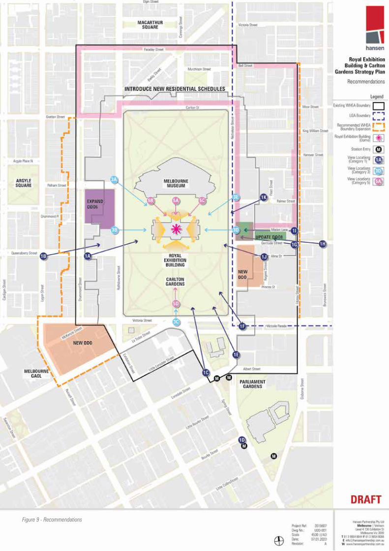
World Heritage Strategy Plan Review for the REB & Carlton Gardens World Heritage Environs Area| Visual Framework & Testing
87Hansen Partnership & HLCD Pty Ltd
Figure 9 - Recommendations
Hansen Partnership Pty Ltd
Melbourne | Gold Coast | Vietnamlevel 4 136 Exhibition StMelbourne Vic 3000 t 61 3 9654 8844 f 61 3 9654 8088 e [email protected] hansenpartnership.com.au
ABN 20 079 864 716 | ACN 079 864 716