Appendix E Visual Impact Assessment...Visual Impact Assessment (VIA) operates within the overall...
62
Boundary Street Upgrade Appendix E Review of Environmental Factors Appendix E Visual impact assessment
Transcript of Appendix E Visual Impact Assessment...Visual Impact Assessment (VIA) operates within the overall...

Boundary Street Upgrade Appendix E Review of Environmental Factors
Appendix E Visual impact assessment

BOUNDARY STREET UPGRADEVISUAL IMPACT ASSESSMENT S13-0057 ISSUE C

Cover Image: Heavy traffic on Boundary Street, looking towards the railway bridge

BOUNDARY STREET UPGRADEVISUAL IMPACT ASSESSMENT
Client:SKM100 Christie StreetPO Box 164St Leonards, SydneyNSW 2065
Prepared by
CLOUSTON AssociatesLandscape Architects • Urban Designers • Landscape PlannersLevel 2, 17 Bridge Street • Sydney NSW 2000PO Box R1388 • Royal Exchange NSW 1225 • AustraliaTelephone +61 2 8272 4999 • Facsimile +61 2 8272 4998Contact: Leonard LynchEmail • [email protected] • www.clouston.com.au
Document Issue Date Status Verified ValidatedS13-0057 A 31/07/2013 DRAFT MK
B 02/09/2013 DRAFT MKC 18/10/2013 FINAL MK CL
Note: This document is Preliminary unless Validated.
S13-0057 • OCT 2013

This page is intentionally blank
BOUNDARY STREET UPGRADE VISUAL IMPACT ASSESSMENT • ISSUE COCT 20134

TABLE OF CONTENTS Title page
CONTENTS
EXECUTIVE SUMMARY 6INTRODUCTION 8METHODOLOGY 10THE SITE 12THE PROPOSAL 15EXISTING VISUAL ENVIRONMENT 20VISUAL CATCHMENT ANALYSIS 22VISUAL IMPACT ASSESSMENT 24VISUAL IMPACT SUMMARY 51MITIGATION RECOMMENDATIONS 56APPENDIX A 59
BOUNDARY STREET UPGRADE VISUAL IMPACT ASSESSMENT • ISSUE C OCT 2013 5

BOUNDARY STREET UPGRADE VISUAL IMPACT ASSESSMENT • ISSUE COCT 20136
INTRODUCTIONThis Visual Impact Assessment (VIA) report identifies and evaluates the visual impacts of the proposed Boundary Street upgrade (the Proposal). This assessment addresses both construction and operational phase impacts of the Proposal, including an analysis of views from key vantage points and proposed mitigation measures to address these impacts.
THE PROPOSALThe Boundary Street upgrade extends from Pacific Highway to Melnotte Avenue, Roseville. The road will be widened to ease traffic congestion with the provision of two dedicated left turn and two dedicated right turn lanes from Boundary Street onto the Pacfic Highway.
THE SITEThe study area is located 500 metres south of Roseville Station and one kilometer north of Chatswood Station. The site is composed of mostly residential land uses, with a rail corridor crossing over Boundary Street adjacent to Hill Street. The site straddles Willoughby City Council to the south and Ku-ring-gai Council to the north. There is a high density of street tree planting and other vegetation along the road corridor.
VISUAL IMPACT ASSESSMENTOverall, the Boundary Street upgrade proposal can be said to be in keeping with the scale and bulk of existing road infrastructure in the area. The changes affect a limited number of properties and the upgrade is not expected to have a major impact on visual amenity once construction is complete.
Of the eleven receptors identified within this report, four recorded an impact rating of ‘High’ or ‘Moderate/High’ during the operational phase. These receptors have the greatest potential to be visually impacted by some aspect of the proposal.
• Viewpoint 3 - Road users and pedestrians on Boundary Street (near Archer Street).
• Viewpoint 4 - Five residential properties along the southern edge of Boundary Street (west of Archer Street).
• Viewpoint 5 - Six residential properties on the northern side of Boundary Street (west of Archer Street).
• Viewpoint 6 - Five residential properties along the northern edge of Boundary Street (east of Archer Street).
The residential scale and character of the Boundary Street road corridor is likely to change in the short to mid term as development along the road becomes more dense due to changes in planning controls. This will further reduce the sensitivity of the road corridor to change, leading to a reduction in the visual impacts associated with the proposal. Mitigation measures are crucial to ensure that the existing pleasant streetscape of the road corridor is preserved.
EXECUTIVE SUMMARY
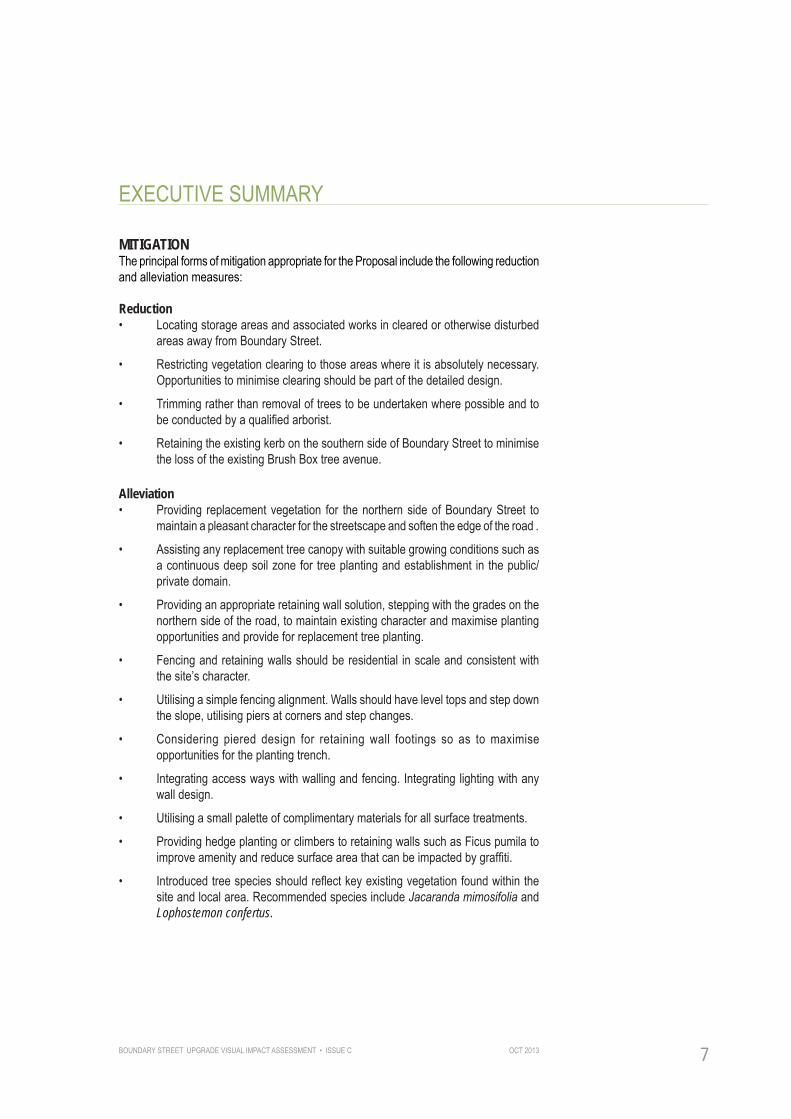
EXECUTIVE SUMMARY
BOUNDARY STREET UPGRADE VISUAL IMPACT ASSESSMENT • ISSUE C OCT 2013 7
MITIGATIONThe principal forms of mitigation appropriate for the Proposal include the following reduction and alleviation measures:
Reduction• Locating storage areas and associated works in cleared or otherwise disturbed
areas away from Boundary Street.
• Restricting vegetation clearing to those areas where it is absolutely necessary. Opportunities to minimise clearing should be part of the detailed design.
• Trimming rather than removal of trees to be undertaken where possible and to be conducted by a qualified arborist.
• Retaining the existing kerb on the southern side of Boundary Street to minimise the loss of the existing Brush Box tree avenue.
Alleviation• Providing replacement vegetation for the northern side of Boundary Street to
maintain a pleasant character for the streetscape and soften the edge of the road .
• Assisting any replacement tree canopy with suitable growing conditions such as a continuous deep soil zone for tree planting and establishment in the public/private domain.
• Providing an appropriate retaining wall solution, stepping with the grades on the northern side of the road, to maintain existing character and maximise planting opportunities and provide for replacement tree planting.
• Fencing and retaining walls should be residential in scale and consistent with the site’s character.
• Utilising a simple fencing alignment. Walls should have level tops and step down the slope, utilising piers at corners and step changes.
• Considering piered design for retaining wall footings so as to maximise opportunities for the planting trench.
• Integrating access ways with walling and fencing. Integrating lighting with any wall design.
• Utilising a small palette of complimentary materials for all surface treatments.
• Providing hedge planting or climbers to retaining walls such as Ficus pumila to improve amenity and reduce surface area that can be impacted by graffiti.
• Introduced tree species should reflect key existing vegetation found within the site and local area. Recommended species include Jacaranda mimosifolia and Lophostemon confertus.

BOUNDARY STREET UPGRADE VISUAL IMPACT ASSESSMENT • ISSUE COCT 20138
PURPOSE OF THE REPORTThe purpose of this report and the overall Review of Environmental Factors (REF) is to seek planning approval for the Boundary Street Upgrade, in accordance with Part 5 of the Environmental Planning and Assessment Act 1979 (EP&A Act).
This assessment is an independent report and is based on a professional analysis of the landscape and the proposal at the time of writing. The current and potential future viewers (visual receptors) themselves have not been consulted about their perceptions; the analysis and conclusions are therefore based solely on a professional assessment of the anticipated impacts, based on a best practice methodology.
Visual Impact Assessment (VIA) operates within the overall framework of an REF. It aims to ensure that all possible effects of change and development in the landscape, views and visual amenity are taken into account. Visual effects assessment is concerned with how the surroundings of individuals or groups of people may be specifically affected by change in the landscape, both quantitatively and qualitatively.
Judgement as to the significance of the effects is arrived at by a process of reasoning, based upon analysis of the baseline conditions, identification of receptors and assessment of their sensitivity, and the magnitude and nature of the changes that may result from the Proposal.
INTRODUCTION

BOUNDARY STREET UPGRADE VISUAL IMPACT ASSESSMENT • ISSUE C OCT 2013 9
INTRODUCTION
TERMS USED IN THE REPORTThe following provides a brief explanation of the terms and abbreviations commonly used in VIA reports and which appear in this report:
Duration: The length of time the visual receptor is exposed to the view. Magnitude: The scale, form and character of a development proposal or change in the landscape. In the case of visual assessment, also how far the proposal is from the receptor. Combined with sensitivity provides a measurement of impact. Magnitude of change: A quantitative assessment of the change in compositional elements of the view. Overall Visual Impact Rating: Determined by cross referencing sensitivity with magnitude.Quantum of view: The openness of the view and the angle of the view to the visual receptor.Sensitivity: The relative ability of a visual receptor to respond to and, where appropriate, accommodate change of a particular type. Combined with magnitude provides a measurement of impact for the visual receptor. View: The sight or prospect of some landscape or scene.Viewshed: The area which the proposal is visible to the human eye from a fixed vantage point.Visual Amenity: The measure of the visual quality of a site or area experienced by residents, workers or visitors. It is the collective impact of the visual components which make a site or an area pleasant to be in. Visual Impact: The impacts on the views from residences and other public places.Visual Receptor: The public or community at large who would have views of the proposal site either by virtue of where they live and/or work or from transport routes, paths, lookouts and the like.Visual Catchment: The area from which a particular point is visible, taking into account topography, vegetation and built form.

BOUNDARY STREET UPGRADE VISUAL IMPACT ASSESSMENT • ISSUE COCT 201310
METHODOLOGY
METHODOLOGYThis report has adopted the Guidelines for Landscape Character and Visual Impact Assessment as published by the Roads and Maritime Service, RMS. These provide the only documented guidelines for VIA by an Australian Government Agency and are considered the most appropriate for this study.
Key components of the VIA methodology include:• Site analysis - Based on desk top and field analysis, the natural environment
is identified and described as well as the human intervention and shaping of that environment, including settlements and the interaction between place and community.
• Assessment of the visibility of the Proposal - Based on desk top and site analysis, the extent of the development that is visible is defined.
• Identificationof key viewpoints -Based on desktop and field analysis, a schedule of key viewpoints is developed.
• Assessment of visual impacts - The unmitigated impact of the development on each representative viewpoint is assessed. Impacts are based on a composite of the sensitivity of the view and magnitude of the development in that view, before any mitigation strategy has been put in place.
• Cumulative Impact Analysis - The visual impact of any other similar nearby developments and potential developments is assessed.
• Development of mitigation strategy - Principles and strategies are developed to mitigate landscape character and visual impacts in the ongoing development of the design.

BOUNDARY STREET UPGRADE VISUAL IMPACT ASSESSMENT • ISSUE C OCT 2013 11
METHODOLOGY
REPORT STRUCTURE Following an introduction section that describes the existing site and the proposal, the VIA is structured in two parts:
Part A - Visual Impact Assessment Identification and analysis of impacts of the proposal on key viewpoints.
Part B - Mitigation RecommendationsDiscussion of the means by which the visual impacts identified can be precluded, reduced or offset.
SUPPORTING DOCUMENTSThe Boundary Street Intersection Improvements Concept Design Report March 2012 GHDhas assisted in the compilation of this report.

BOUNDARY STREET UPGRADE VISUAL IMPACT ASSESSMENT • ISSUE COCT 201312
THE SITEBoundary Street is a two-way carriageway consisting of three traffic lanes under the North Shore Line railway bridge. For commuters in suburbs east of Middle Harbour such as Killarney Heights, Forestville, Frenchs Forest, Belrose and Davidson, Boundary Street provides the most direct link to the Pacific Highway.
Middle Harbour and the associated valley form a significant natural barrier to the east extending north to St Ives. Roseville bridge provides a strategic connection delivering traffic from these suburbs via Warringah Road to Boundary street (refer Figure 1A and 1B).
Crossing the study area at its western end is the North Shore Rail Line linking the Sydney CBD with Hornsby and the Central Coast. The road has a restricted vertical clearance of 4.2 metres under the existing rail bridge.
The study area is located 500 metres south of Roseville Station and one kilometre north of Chatswood Station (refer Figure 1C).
Land use Residential is the dominant land use in the immediate vicinity of Boundary Street between the Pacific Highway and Archer Street. The other significant land use is the rail corridor, which crosses over Boundary Street adjacent to Hill Street.
Statutory and Planning ContextThe site straddles the local government boundaries of Willoughby City Council to the south and Ku-ring-gai Council to the north. Given the site’s strategic proximity to Chatswood and Roseville Stations, both councils have made special zoning provisions for this area with substantially increased building densities. The housing type is currently dominated by single storey detached housing in Federation or Interwar bungalow styles. The long term character impacts of introducing higher density buildings on Boundary Street and its surrounds are discussed further in this report.
TopographyTopography within the study area is generally flat with a gentle slope to the east of Boundary Street.
VegetationStreet trees and other vegetation in the area are made up of a variety of species of varying ages and heights, including, Lophostemon confertus, Jacarandas and Melaleucas, as well as weed species such as Privet and Camphor Laurel.
THE SITE

BOUNDARY STREET UPGRADE VISUAL IMPACT ASSESSMENT • ISSUE C OCT 2013 13
THE SITE
Figure 1A - Site context (not to scale)
Site location
Frenchs Forest
ForestvilleRoseville
Chatswood
Prospect ParramattaReservoir
CBD
Bankstown
Botany Bay
Figure 1B - Site context (not to scale)
North Sydney
St Leonards
Site Location
Sydney CBD
Mosman
Chatswood

BOUNDARY STREET UPGRADE VISUAL IMPACT ASSESSMENT • ISSUE COCT 201314
THE SITE
Chatswood
Roseville
Pacific Highway
North Shore Rail Line
Boundary Street
Study area
Figure 1C - Site context (not to scale)
LEGEND
Rail corridor
Highway
Study Road
BOUNDARY STREET UPGRADE VISUAL IMPACT ASSESSMENT • ISSUE C OCT 2013 15
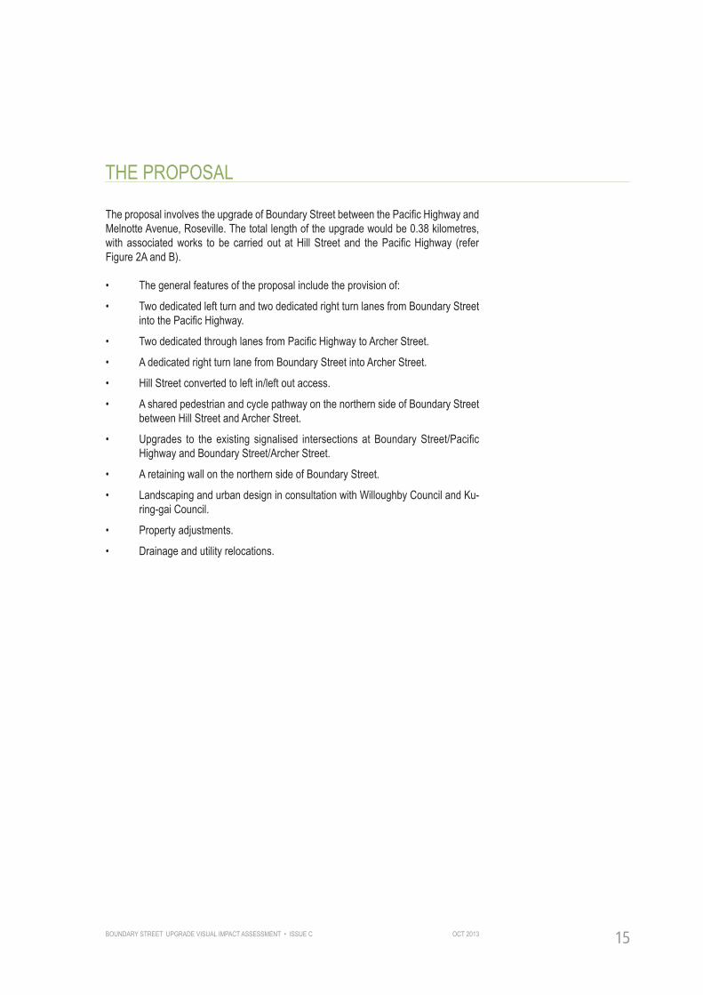
THE PROPOSAL
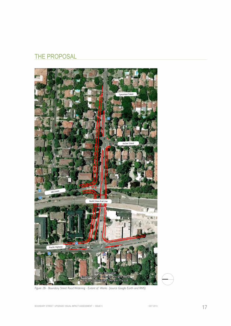
The proposal involves the upgrade of Boundary Street between the Pacific Highway and Melnotte Avenue, Roseville. The total length of the upgrade would be 0.38 kilometres, with associated works to be carried out at Hill Street and the Pacific Highway (refer Figure 2A and B).
• The general features of the proposal include the provision of:
• Two dedicated left turn and two dedicated right turn lanes from Boundary Street into the Pacific Highway.
• Two dedicated through lanes from Pacific Highway to Archer Street.
• A dedicated right turn lane from Boundary Street into Archer Street.
• Hill Street converted to left in/left out access.
• A shared pedestrian and cycle pathway on the northern side of Boundary Street between Hill Street and Archer Street.
• Upgrades to the existing signalised intersections at Boundary Street/Pacific Highway and Boundary Street/Archer Street.
• A retaining wall on the northern side of Boundary Street.
• Landscaping and urban design in consultation with Willoughby Council and Ku-ring-gai Council.
• Property adjustments.
• Drainage and utility relocations.

BOUNDARY STREET UPGRADE VISUAL IMPACT ASSESSMENT • ISSUE COCT 201316
THE PROPOSAL
Figure 2A - Boundary Street Road Widening - Design Intent (source RMS)
Poten
tial s
ite
comp
ound
loc
ation
BOUNDARY STREET UPGRADE VISUAL IMPACT ASSESSMENT • ISSUE C OCT 2013 17
THE PROPOSAL
Figure 2B - Boundary Street Road Widening - Extent of Works (source Google Earth and RMS)
Pacific Highway
Archer Street
Spearman Street
Hill Street
North Shore Rail Line

BOUNDARY STREET UPGRADE VISUAL IMPACT ASSESSMENT • ISSUE COCT 201318Heavy traffic on Boundary Street, looking west

BOUNDARY STREET UPGRADE VISUAL IMPACT ASSESSMENT • ISSUE C OCT 2013 19
PART A: VISUAL IMPACT ASSESSMENT

BOUNDARY STREET UPGRADE VISUAL IMPACT ASSESSMENT • ISSUE COCT 201320
STUDY AREAThe study area specific to the Visual Impact Assessment comprises that covered by the proposal as shown in Figure 2A and 2B. This includes the surrounding streets likely to be visually impacted by the Proposal.
The extent of the study area includes the Pacific Highway 100 metres north and south of Boundary Street, along Boundary Street from the Pacific Highway through to Spearman Street and the initial 100 metres of Corona, Hill and Archer Streets.
The visual environment of the study area is that of a typical developed urban setting, and is now described from a public and private realm perspective.
PUBLIC DOMAINView corridors to the site exist along roads including the Pacific Highway, Boundary Street, Hill Street and Archer Street. The most distinctive visual feature of Boundary Street is the green planted edge to the northern and southern sides of the road (refer Figure 3A and 3B).
The vegetation on the northern edge is particularly dense and is made up of a variety of tree species of varying ages and heights including Jacarandas and Melaleucas, as well as weed species such as Privet and Camphor Laurel. Whilst the vegetation is not considered ecologically significant, the mass of vegetation provides a visually important edge to the street and screens the residential properties behind.
Similarly, street tree planting of Lophostemon confertus (Brush Box) form a consistent planted edge to the southern side of Boundary Street, partially screening properties behind. These trees while not large or significant individual specimens, are mature and as a group they provide valuable visual amenity.
PRIVATE DOMAINResidential properties alongside the road currently have filtered views to the road corridor, and in some cases are almost completely screened by the surrounding vegetation (refer Figure 3A and 3B). The existing local housing character is predominantly from the period 1920 – 1945 and comprises examples of Inter-War housing. Due to changes in density controls, the residential character is anticipated to change to become high density on the Willoughby and Ku-ring-gai sides.
EXISTING VISUAL ENVIRONMENT

BOUNDARY STREET UPGRADE VISUAL IMPACT ASSESSMENT • ISSUE C OCT 2013 21
EXISTING VISUAL ENVIRONMENT
Figure 3A - Key visual components within study area - looking east (source Nokia Maps)
Figure 3B - Key visual components within study area - looking west (source Nokia Maps)
Vegetated edge to both sides of Boundary Street
Vegetated edge to both sides of
Boundary Street
Pacific Highway
Pacific Highway
Boun
dary
Stree
t
Boundary Street
Archer Street
Hill Street
North Shore Rail Line
Willoughby Council
Willoughby Council
Ku-ring-gai Council
Ku-ring-gai Council
North Shore Rail Line
Residential properties in proximity to road
Residential properties in proximity to road
Extent of works
Residential properties
Visually prominent vegetation

BOUNDARY STREET UPGRADE VISUAL IMPACT ASSESSMENT • ISSUE COCT 201322
VISUAL CATCHMENT ANALYSIS
VISUAL CATCHMENT ANALYSISPrior to the preparation of the detailed visual receptor analysis, a potential visual catchment for the Boundary Street upgrade works was identified through aerial mapping. Figure 4 indicates this approximate catchment as defined and created by topography, road layout, existing built form and vegetation.
KEY VISUAL RECEPTORSDuring a visit to the site, eleven key receptors with the potential to be visually impacted by some element of the proposal were selected (refer Figure 4). These include groups of residential properties along Boundary Street as well as road users and pedestrians.
The locations identified are:
1. Major Road - Pacific Highway - near Boundary Street intersection (looking north and south).
2. Major Road - Boundary Street - near railway bridge (looking west).
3. Major Road - Boundary Street - near Archer Street junction (looking east and west).
4. Private Property - Five residential properties on southern side of Boundary Street, west of Archer Street (looking north).
5. Private Property - Six residential properties on northern side of Boundary Street, west of Archer Street (looking south).
6. Private Property - Five residential properties on northern side of Boundary Street, east of Archer St (looking south).
7. Minor Road - Archer Street - looking north towards Boundary Street junction.
8. Major Road - Boundary Street - near Spearman Street (looking west).
9. Private Property - four properties on southern side of Boundary Street, east of Archer Street (looking north).
10. Minor Road - Hill Street (looking south).
11. Minor Road - Corona Avenue (looking east).

BOUNDARY STREET UPGRADE VISUAL IMPACT ASSESSMENT • ISSUE C OCT 2013 23
VISUAL CATCHMENT ANALYSIS
Figure 4 - Viewpoint Location Map
Potential visual catchment of proposed upgrade
Pacific Highway
Archer Street
Spearman Street
Hill Street
North Shore Rail Line
1
2
11
4
7
3
8
9
5
10
6
1
Boun
dary
Stree
t

BOUNDARY STREET UPGRADE VISUAL IMPACT ASSESSMENT • ISSUE COCT 201324
VIEWPOINT ANALYSISThe following section assesses the visual impact of the proposal on each of the selected viewpoints shown in Figure 4. This includes a description of the current view from each viewpoint followed by a discussion of the potential visual impacts of the proposal on that view at the operational phase.
Each viewpoint is accompanied by a photograph of the current view. For residential receptors, access was not possible to the property itself. A photo was taken at the closest publicly accessible point - often the end of the properties themselves. The description of visual impact is therefore estimated from the property’s main dwelling area.
For a detailed description of the assessment criteria and impact ratings used see Appendix A.
VISUAL IMPACT ASSESSMENT
MAGNITUDE
RECE
PTOR
SEN
SITI
VITY
RECE
PTOR
TYP
E
RECE
PTOR
ID
ENTI
FICA
TION
PHOT
O LO
CATI
ON
DIST
ANCE
QUAN
TUM
OF V
IEW
DURA
TION
MAGN
ITUD
E OF
CHA
NGE
SUMM
ARY
OF R
ATIN
GS
Major Road
Pacific Highway 1 H L L L L M/L
Visual Impact Rating LOW
OPERATION PHASE
VIEWPOINT 1
LocationPacific Highway - travelling north and southDistance to proposal - 0-100m
DescriptionThis receptors are road users on the Pacific Highway travelling north (A) and south (B), with views towards the Boundary Street intersection.
Current ViewAs shown in Photo 1A, the view on the approach to the Boundary Street intersection whislt travelling north is of a vegetated corner in the foreground. Views of the property behind are obscured by vegetation. The 7-Eleven gas station is visible on the eastern side of the road. Whislt travelling south the intersection is less visible as seen in photo 1B.
OperationThe widened road corridor will be visible by road users travelling both north and south on the Pacific Highway. The most noticeable change will be the removal of vegetation on the northern edge of Boundary Street and the addition of an embankment or retaining wall. The proposal, however, matches the scale and bulk of existing road infrastructure in the area and will not present a major visual impact from these locations.
B
A
BOUNDARY STREETPACIFIC HIGHWAY
Location map
Outline of proposed worksPhoto location and direction marker
Viewpoint location
Description of current view
Receptor marker
Rating table
Description of expected visual impact at operational stages
Overall operational impact rating
Viewpoint number

BOUNDARY STREET UPGRADE VISUAL IMPACT ASSESSMENT • ISSUE C OCT 2013 25
VISUAL IMPACT ASSESSMENT
METHODOLOGYThe overall impact rating of the proposal on any given receptor is based on factors of magnitude and sensitivity.
Sensitivity - each visual receptor type has an inherent and varied sensitivity to change in the visual scene based on their personal context in which the view is being experienced. This will have a direct bearing on the perception of visual impact experienced by the receptor and qualifies the quantitative impacts. Appendix A describes the levels of sensitivity for each receptor type.
Magnitude - the magnitude of the visual effects of the development within the landscape. A series of quantitative assessments are studied, including distance from development, quantum of view, duration of view and magnitude of change. Appendix A describes the ratings assigned to these quantitative assessments.
Overall impact ratingThe severity of these impacts is calculated using matrix Table 01 - based on a combination of magnitude and sensitivity.
MAGNITUDE
SENS
ITIV
ITY
High High/ Moderate Moderate Moderate/ Low Low Negligible
High High High Moderate-High Moderate-High Moderate Negligible
High/ Moderate High Moderate-High Moderate-High Moderate Moderate Negligible
Moderate Moderate-High Moderate-High Moderate Moderate Moderate-Low Negligible
Moderate/ Low Moderate-High Moderate Moderate Moderate-Low Moderate-Low Negligible
Low Moderate Moderate Moderate-Low Moderate-Low Low Negligible
NegligibleNegligible Negligible Negligible Negligible Negligible Negligible
Table 01: Overall impact rating as a combination of Sensitivity and Magnitude. Source: RTA (2009) Guideline for Landscape Character + Visual Assessment

BOUNDARY STREET UPGRADE VISUAL IMPACT ASSESSMENT • ISSUE COCT 201326
VISUAL IMPACT ASSESSMENT
VIEWPOINT 1B
A
Photo location
Receptor location
A
Vegetation to be removed from corner of road
BOUNDARY STREETPACIFIC HIGHWAY
LocationPacific Highway - travelling north and southDistance to proposal - 0-100 metres
DescriptionThese receptors are road users on the Pacific Highway travelling north (A) and south (B), with views towards the Boundary Street intersection.
Current ViewAs shown in Photo 1A, the view on the approach to the Boundary Street intersection whilst travelling north is of a vegetated corner in the foreground. Views of the property behind are obscured by vegetation. The 7-Eleven service station is visible on the eastern side of the road. Whilst travelling south, the intersection is less visible as seen in photo 1B, with the view dominated by the Pacific Highway road corridor extending into the distance.
VISUAL IMPACTOperationThe widened road corridor will be visible by road users travelling both north and south on the Pacific Highway. The most noticeable change will be the removal of vegetation on the northern edge of Boundary Street and the addition of an embankment or retaining wall. The proposal, however, matches the scale and bulk of existing road infrastructure in the area and is not expected to present a major visual impact or change to the composition of the scene from these locations.

CLARENCE RIVER WAY MASTERPLAN - COMMUNITY CONSULTATION REVIEW - CLIENT REVIEW DRAFT MARCH 2012 27
VISUAL IMPACT ASSESSMENT
1A - Existing view north along Pacific Highway towards Boundary Street 1B - Existing view along Pacific Highway towards Boundary Street
Vegetation to be removed from corner of road Vegetation to be removed from corner of road
Embankment or retaining wall to be placed along edge of new road alignment
RECE
PTOR
TYP
E
RECE
PTOR
ID
ENTI
FICA
TION
PHOT
O LO
CATI
ON
DIST
ANCE
QUAN
TUM
OF V
IEW
DURA
TION
MAGN
ITUD
E OF
CHA
NGE
SUMM
ARY
OF R
ATIN
GS
RECE
PTOR
SEN
SITI
VITY
MAGNITUDE
OPERATION PHASEMajor Pacific Highway 1 H L L L L M/LRoad
Visual Impact Rating MODERATE/LOW
From Table 01, using a combination of sensitivity and magnitude ratings.
BOUNDARY STREET UPGRADE VISUAL IMPACT ASSESSMENT • ISSUE COCT 201328
VISUAL IMPACT ASSESSMENT
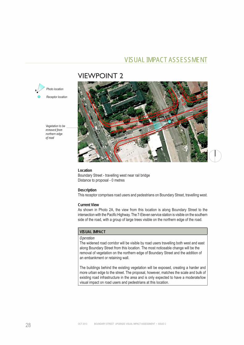
VIEWPOINT 2
Vegetation to be removed from northern edge of road
Photo location
Receptor location
A
A
BOUNDARY STREET
PACIFIC HIGHWAY
HILL STREET
LocationBoundary Street - travelling west near rail bridgeDistance to proposal - 0 metres
DescriptionThis receptor comprises road users and pedestrians on Boundary Street, travelling west.
Current ViewAs shown in Photo 2A, the view from this location is along Boundary Street to the intersection with the Pacific Highway. The 7-Eleven service station is visible on the southern side of the road, with a group of large trees visible on the northern edge of the road.
VISUAL IMPACTOperationThe widened road corridor will be visible by road users travelling both west and eastalong Boundary Street from this location. The most noticeable change will be theremoval of vegetation on the northern edge of Boundary Street and the addition ofan embankment or retaining wall.
The buildings behind the existing vegetation will be exposed, creating a harder and more urban edge to the street. The proposal, however, matches the scale and bulk of existing road infrastructure in the area and is only expected to have a moderate/low visual impact on road users and pedestrians at this location.
BOUNDARY STREET UPGRADE VISUAL IMPACT ASSESSMENT • ISSUE C OCT 2013 29
VISUAL IMPACT ASSESSMENT
2A - Existing view along Boundary Street from below rail bridge, looking west
Vegetation to be removed from northern edge of road
RECE
PTOR
TYP
E
RECE
PTOR
ID
ENTI
FICA
TION
PHOT
O LO
CATI
ON
DIST
ANCE
QUAN
TUM
OF V
IEW
DURA
TION
MAGN
ITUD
E OF
CHA
NGE
SUMM
ARY
OF R
ATIN
GS
RECE
PTOR
SEN
SITI
VITY
MAGNITUDE
OPERATION PHASEMajor Boundary Street 2 H M/L L M/L L M/LRoad
Visual Impact Rating MODERATE/LOWFrom Table 01, using a combination of sensitivity and magnitude

BOUNDARY STREET UPGRADE VISUAL IMPACT ASSESSMENT • ISSUE COCT 201330
VISUAL IMPACT ASSESSMENT
VIEWPOINT 3
Photo location
Receptor location
A
A
BVegetation to be removed on northern and southern side of road
BOUNDARY STREET
HILL STREET
ARCHER STREET
LocationBoundary Street, near Archer St looking west (A) and east (B)Distance to proposal - 0 metres
DescriptionThis receptor comprises road users and pedestrians on Boundary Street, travelling east and west.
Current ViewAs shown in Photo 3A, the view from this location is west along the Boundary Street road corridor. The railway bridge is visible in the middle distance with street tree planting visible on the southern edge of the road and a dense vegetated edge to the northern side. The view is similar looking east (Photo 3B), with a planted edge visible on both sides of the road, screening the residential properties behind.
VISUAL IMPACTOperationThe widened road corridor will be visible by road users and pedestrians travelling both west and east along Boundary Street from this location. The most noticeable change will be the removal of the dense vegetation on the northern edge of Boundary Street, the addition of an embankment/retaining wall and the removal of street trees on the southern edge. The existing/proposed buildings behind the vegetation on the northern side of the road will be exposed, creating a harder and more urban edge to the street.

BOUNDARY STREET UPGRADE VISUAL IMPACT ASSESSMENT • ISSUE C OCT 2013 31
VISUAL IMPACT ASSESSMENT
3A - Existing view along Boundary Street looking west
3B - Existing view along Boundary Street looking east
Vegetation to be removed from northern edge of road
Vegetation to be removed from southern edge of road
Embankment or retaining wall to be placed along edge of new road alignment
Embankment or retaining wall to be placed along edge of new road
Vegetation to be removed from northern edge of road
Vegetation to be removed from southern edge of road

BOUNDARY STREET UPGRADE VISUAL IMPACT ASSESSMENT • ISSUE COCT 201332
VISUAL IMPACT ASSESSMENT
MAGNITUDERE
CEPT
OR T
YPE
RECE
PTOR
ID
ENTI
FICA
TION
PHOT
O LO
CATI
ON
OPERATION PHASEMajor Boundary Street 3 H M/L L M/H M/H M
DIST
ANCE
RoadQU
ANTU
M OF
VIE
WVisual Impact Rating MODERATE/HIGH
DURA
TION
From Table 01, using a combination of sensitivity and magnitude
MAGN
ITUD
E OF
CHA
NGE
SUMM
ARY
OF R
ATIN
GS
RECE
PTOR
SEN
SITI
VITY

BOUNDARY STREET UPGRADE VISUAL IMPACT ASSESSMENT • ISSUE C OCT 2013 33
VISUAL IMPACT ASSESSMENT
VIEWPOINT 4
Vegetation to be removed from northern and southern side of road
Photo location
Receptor location
A
ABOUNDARY STREET
ARCHER STREET
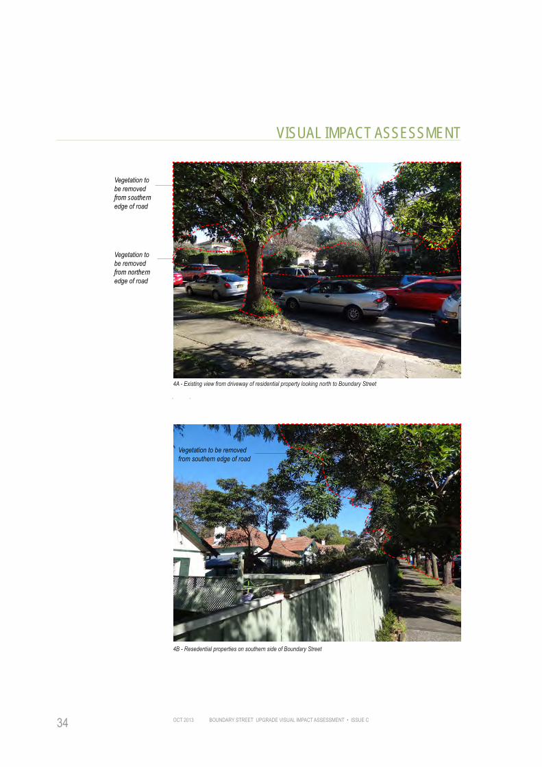
LocationFive Residential properties to the southern side of Boundary Street.Distance to proposal - 3 metres.
DescriptionThe photo is taken from the street end of the driveway of property A.
Current ViewAs shown in Photo 4A and 4B, the outlook from these properties is north towards the road. Views towards Boundary Street are partially screened by vegetation within the properties garden, a 1.5 metres high boundary fence and street trees next to the footpath.
VISUAL IMPACTOperationRemoval of vegetation on the southern and northern side of Boundary Street will be the most visible element of change from these properties. The buildings are single storey and the fence and existing garden planting will partially screen views of the widened road corridor and removed vegetation. The removal of all vegetation within the road corridor, however, will noticeably alter the character of the area and leave these residents with a greater exposer to the road environment.
MAGNITUDE
RECE
PTOR
SEN
SITI
VITY
RECE
PTOR
TYP
E
RECE
PTOR
ID
ENTI
FICA
TION
PHOT
O LO
CATI
ON
DIST
ANCE
QUAN
TUM
OF V
IEW
DURA
TION
MAGN
ITUD
E OF
CHA
NGE
SUMM
ARY
OF R
ATIN
GS
BOUNDARY STREET UPGRADE VISUAL IMPACT ASSESSMENT • ISSUE COCT 201334
VISUAL IMPACT ASSESSMENT
4A - Existing view from driveway of residential property looking north to Boundary Street
4B - Resedential properties on southern side of Boundary Street
Vegetation to be removed from southern edge of road
Vegetation to be removed from northern edge of road
Vegetation to be removed from southern edge of road

BOUNDARY STREET UPGRADE VISUAL IMPACT ASSESSMENT • ISSUE C OCT 2013 35
VISUAL IMPACT ASSESSMENT
RECE
PTOR
TYP
E
RECE
PTOR
ID
ENTI
FICA
TION
MAGNITUDE
PHOT
O LO
CATI
ON
DIST
ANCE
QUAN
TUM
OF V
IEW
DURA
TION
MAGN
ITUD
E OF
CHA
NGE
OPERATION PHASEPrivate Boundary Street 4 H M M/H M/H M/H M/H
SUMM
ARY
OF R
ATIN
GSProperty
Visual Impact Rating MODERATE/HIGHRE
CEPT
OR S
ENSI
TIVI
TYFrom Table 01, using a combination of sensitivity and magnitude

BOUNDARY STREET UPGRADE VISUAL IMPACT ASSESSMENT • ISSUE COCT 201336
VISUAL IMPACT ASSESSMENT
VIEWPOINT 5
Vegetation to be removed from northern edge of road
Photo location
Receptor location
A
A
ARCHER STREET
BOUNDARY STREET
Five properties subject to DA and likely to be demolished
LocationSix residential properties located on northern side of Boundary Street, west of Archer StreetDistance to proposal - 6 metres
DescriptionThe photo is taken from the elevated footpath that runs along the street front of these properties.
Current ViewAs shown in Photo 5, the current view from these residents is towards the road, heavily screened by a green wall of vegetation. The vegetation consist of trees and shrubs planted along the verge, to the front of property boundaries and within front gardens.
VISUAL IMPACTOperationThe widened road will be at a much closer proximity to the front of these properties and the road, pedestrians and traffic on Boundary Street will be fully visible. There will be a noticable loss of vegetation infront of the properties and along the southern edge of the road.
Of the six properties assessed, five have been purchased by a developer and may be demolished (as indicated by the dashed line above). A Development Application has been approved to develop the land into a block of multistorey apartments. This assessment considers the properties as they currently stand, although the impact rating will reduce if the land is developed and apartments constructed.
Any new apartment development will have a lower visual sensitivity and the magnitude of change will be reduced as the vegetation will likely be removed before the apartments are occupied. Planting within the new development may assist in partially screening views of the road.

BOUNDARY STREET UPGRADE VISUAL IMPACT ASSESSMENT • ISSUE C OCT 2013 37
VISUAL IMPACT ASSESSMENT
5 - Existing view from footpath along northern side of Boundary Street
All vegetation to be removed from northern edge of Boundary Street
RECE
PTOR
TYP
E
RECE
PTOR
ID
ENTI
FICA
TION
PHOT
O LO
CATI
ON
DIST
ANCE
QUAN
TUM
OF V
IEW
DURA
TION
MAGN
ITUD
E OF
CHA
NGE
SUMM
ARY
OF R
ATIN
GS
RECE
PTOR
SEN
SITI
VITY
MAGNITUDE
OPERATION PHASE
OPERATION PHASEPrivate Boundary Street 5 H H M/H H H M/HProperty
Visual Impact Rating HIGHFrom Table 01, using a combination of sensitivity and magnitude
BOUNDARY STREET UPGRADE VISUAL IMPACT ASSESSMENT • ISSUE COCT 201338
VISUAL IMPACT ASSESSMENT
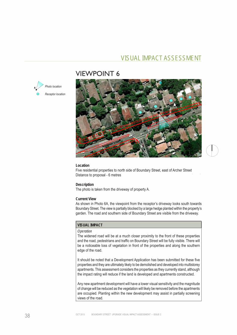
VIEWPOINT 6
A
ARCHER STREET
BOUNDARY STREET
Photo location
Receptor location
A
LocationFive residential properties to north side of Boundary Street, east of Archer StreetDistance to proposal - 6 metres
DescriptionThe photo is taken from the driveway of property A.
Current ViewAs shown in Photo 6A, the viewpoint from the receptor’s driveway looks south towards Boundary Street. The view is partially blocked by a large hedge planted within the property’s garden. The road and southern side of Boundary Street are visible from the driveway.
VISUAL IMPACTOperationThe widened road will be at a much closer proximity to the front of these properties and the road, pedestrians and traffic on Boundary Street will be fully visible. There will be a noticeable loss of vegetation in front of the properties and along the southern edge of the road.
It should be noted that a Development Application has been submitted for these five properties and they are ultimately likely to be demolished and developed into multistorey apartments. This assessment considers the properties as they currently stand, although the impact rating will reduce if the land is developed and apartments constructed.
Any new apartment development will have a lower visual sensitivity and the magnitude of change will be reduced as the vegetation will likely be removed before the apartments are occupied. Planting within the new development may assist in partially screening views of the road.

BOUNDARY STREET UPGRADE VISUAL IMPACT ASSESSMENT • ISSUE C OCT 2013 39
VISUAL IMPACT ASSESSMENT
6A - Existing view looking south to Boundary Street
6B - Garden of property on northern edge of Boundary Street
Approximate constructionline

BOUNDARY STREET UPGRADE VISUAL IMPACT ASSESSMENT • ISSUE COCT 201340
VISUAL IMPACT ASSESSMENT
MAGNITUDERE
CEPT
OR T
YPE
RECE
PTOR
ID
ENTI
FICA
TION
PHOT
O LO
CATI
ON
OPERATION PHASEPrivate Boundary Street 6 H H M/H H H M/H
DIST
ANCE
Property
QUAN
TUM
OF V
IEW
Visual Impact Rating HIGHDU
RATI
ONFrom Table 01, using a combination of sensitivity and magnitude
MAGN
ITUD
E OF
CHA
NGE
SUMM
ARY
OF R
ATIN
GS
RECE
PTOR
SEN
SITI
VITY

BOUNDARY STREET UPGRADE VISUAL IMPACT ASSESSMENT • ISSUE C OCT 2013 41
VISUAL IMPACT ASSESSMENT
VIEWPOINT 7Vegetation to be removed on northern edge of Boundary Street
Photo location
Receptor location
A
ARCHER STREET
BOUNDARY STREET
LocationArcher Street, looking northDistance to proposal - 100 metres
DescriptionThis receptor comprises road users on Archer Street, looking north towards the Boundary Street junction.
Current ViewAs shown in Photo 7A, the view from this location is of an urban residential setting along a tree lined road towards the junction. Vegetation on the northern side of Boundary Street is clearly visible at the end of the road corridor.
VISUAL IMPACTOperationThere will be a noticeable removal of vegetation at the end of the road corridor although this compromises only a small part of the total view. As road users and pedestrians travel closer to the Boundary Street intersection, the loss of vegetation will become increasingly apparent, although a major reduction in visual amenity is unlikely.
MAGNITUDE
RECE
PTOR
SEN
SITI
VITY
RECE
PTOR
TYP
E
RECE
PTOR
ID
ENTI
FICA
TION
PHOT
O LO
CATI
ON
DIST
ANCE
QUAN
TUM
OF V
IEW
DURA
TION
MAGN
ITUD
E OF
CHA
NGE
SUMM
ARY
OF R
ATIN
GS

BOUNDARY STREET UPGRADE VISUAL IMPACT ASSESSMENT • ISSUE COCT 201342
VISUAL IMPACT ASSESSMENT
7A - Existing view along Archer Street looking north towards Boundary Street
Vegetation to be removed from northern edge of Boundary Street
RECE
PTOR
TYP
E
RECE
PTOR
ID
ENTI
FICA
TION
PHOT
O LO
CATI
ON
DIST
ANCE
QUAN
TUM
OF V
IEW
DURA
TION
MAGN
ITUD
E OF
CHA
NGE
SUMM
ARY
OF R
ATIN
GS MAGNITUDE
RECE
PTOR
SEN
SITI
VITY
OPERATION PHASELocal Archer Street 7 M M/L L M/L M/L M/LRoad
Visual Impact Rating MODERATE/LOWFrom Table 01, using a combination of sensitivity and magnitude

BOUNDARY STREET UPGRADE VISUAL IMPACT ASSESSMENT • ISSUE C OCT 2013 43
VISUAL IMPACT ASSESSMENT
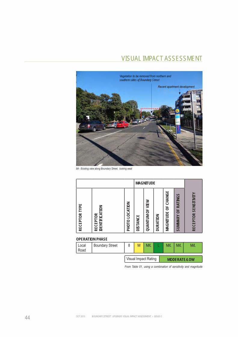
VIEWPOINT 8
New apartment building
Photo location
Receptor location
A
SPEARMAN STREET
BOUNDARY STREET
LocationBoundary Street near Spearman Street, looking west Distance to proposal - 90 metres
DescriptionThis receptor comprises road users on Boundary Street, near Spearman Street, looking west.
Current ViewAs shown in Photo 8, the view from this location is of a residential setting along the Boundary Street road corridor towards the rail bridge. On the northern side, vegetation has been cleared and a multistorey apartment building erected. On the southern side, a row of street trees is visible, extending to the top of the hill in the middle distance.
VISUAL IMPACTOperationThere will be a noticeable removal of vegetation at the end of the road corridor, compromising a small part of the total view. The widened road will be hard to distinguish from this location and will match the scale and bulk of the existing road infrastructure. The apartment building seen in this view is representative of the type of character that will likely exist along the road once future development takes place. It is noticeable that there are no street trees to the front of this apartment and the building is not screened from the road, resulting to a hard urban edge to Boundary Street in this location.
MAGNITUDE
RECE
PTOR
SEN
SITI
VITY
RECE
PTOR
TYP
E
RECE
PTOR
ID
ENTI
FICA
TION
PHOT
O LO
CATI
ON
DIST
ANCE
QUAN
TUM
OF V
IEW
DURA
TION
MAGN
ITUD
E OF
CHA
NGE
SUMM
ARY
OF R
ATIN
GS
BOUNDARY STREET UPGRADE VISUAL IMPACT ASSESSMENT • ISSUE COCT 201344
VISUAL IMPACT ASSESSMENT
8A - Existing view along Boundary Street, looking west
Vegetation to be removed from northern and southern sides of Boundary Street
Recent apartment development
RECE
PTOR
TYP
E
RECE
PTOR
ID
ENTI
FICA
TION
PHOT
O LO
CATI
ON
DIST
ANCE
QUAN
TUM
OF V
IEW
DURA
TION
MAGN
ITUD
E OF
CHA
NGE
SUMM
ARY
OF R
ATIN
GS MAGNITUDE
RECE
PTOR
SEN
SITI
VITY
OPERATION PHASELocal Boundary Street 8 M M/L L M/L M/L M/LRoad
Visual Impact Rating MODERATE/LOWFrom Table 01, using a combination of sensitivity and magnitude
BOUNDARY STREET UPGRADE VISUAL IMPACT ASSESSMENT • ISSUE C OCT 2013 45
MAGNITUDE
RECE
PTOR
SEN
SITI
VITY
RECE
PTOR
TYP
E
RECE
PTOR
ID
ENTI
FICA
TION
PHOT
O LO
CATI
ON
DIST
ANCE
QUAN
TUM
OF V
IEW
DURA
TION
MAGN
ITUD
E OF
CHA
NGE
SUMM
ARY
OF R
ATIN
GS
VISUAL IMPACT ASSESSMENT
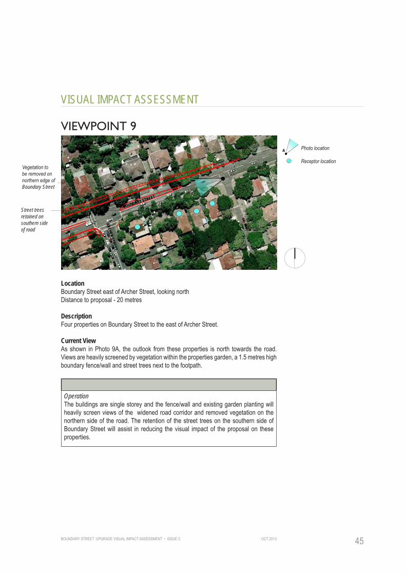
VIEWPOINT 9
Vegetation to be removed on northern edge of Boundary Street
Street trees retained on southern side of road
Photo location
Receptor location
A
ARCHER STREET
BOUNDARY STREET
LocationBoundary Street east of Archer Street, looking northDistance to proposal - 20 metres
DescriptionFour properties on Boundary Street to the east of Archer Street.
Current ViewAs shown in Photo 9A, the outlook from these properties is north towards the road. Views are heavily screened by vegetation within the properties garden, a 1.5 metres high boundary fence/wall and street trees next to the footpath.
VISUAL IMPACTOperationThe buildings are single storey and the fence/wall and existing garden planting will heavily screen views of the widened road corridor and removed vegetation on the northern side of the road. The retention of the street trees on the southern side of Boundary Street will assist in reducing the visual impact of the proposal on these properties.
BOUNDARY STREET UPGRADE VISUAL IMPACT ASSESSMENT • ISSUE COCT 201346
VISUAL IMPACT ASSESSMENT
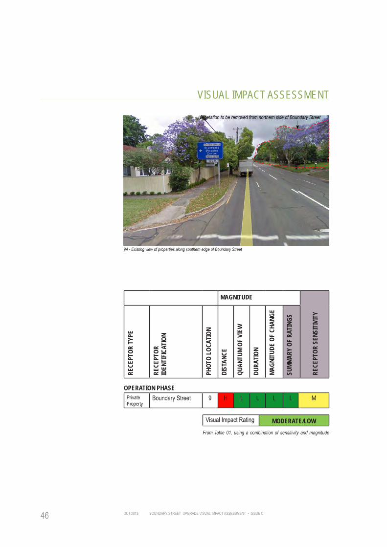
9A - Existing view of properties along southern edge of Boundary Street
Vegetation to be removed from northern side of Boundary Street
RECE
PTOR
TYP
E
RECE
PTOR
ID
ENTI
FICA
TION
PHOT
O LO
CATI
ON
DIST
ANCE
QUAN
TUM
OF V
IEW
DURA
TION
MAGN
ITUD
E OF
CHA
NGE
SUMM
ARY
OF R
ATIN
GS MAGNITUDE
RECE
PTOR
SEN
SITI
VITY
OPERATION PHASEPrivate Boundary Street 9 H L L L L MProperty
Visual Impact Rating MODERATE/LOWFrom Table 01, using a combination of sensitivity and magnitude
BOUNDARY STREET UPGRADE VISUAL IMPACT ASSESSMENT • ISSUE C OCT 2013 47
VISUAL IMPACT ASSESSMENT
MAGNITUDE
RECE
PTOR
SEN
SITI
VITY
RECE
PTOR
TYP
E
RECE
PTOR
ID
ENTI
FICA
TION
PHOT
O LO
CATI
ON
DIST
ANCE
QUAN
TUM
OF V
IEW
DURA
TION
MAGN
ITUD
E OF
CHA
NGE
SUMM
ARY
OF R
ATIN
GS
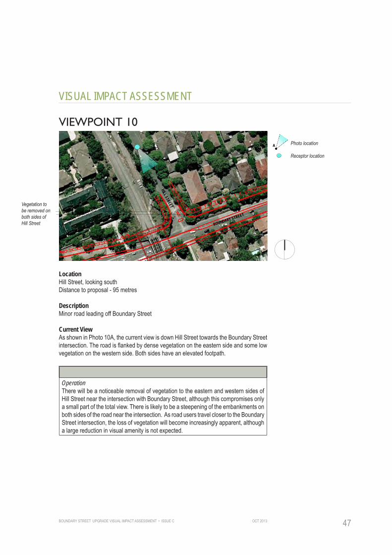
VIEWPOINT 10
Vegetation to be removed on both sides of Hill Street
Photo location
Receptor location
A
HILL STREETBOUNDARY STREET
LocationHill Street, looking southDistance to proposal - 95 metres
DescriptionMinor road leading off Boundary Street
Current ViewAs shown in Photo 10A, the current view is down Hill Street towards the Boundary Street intersection. The road is flanked by dense vegetation on the eastern side and some low vegetation on the western side. Both sides have an elevated footpath.
VISUAL IMPACTOperationThere will be a noticeable removal of vegetation to the eastern and western sides of Hill Street near the intersection with Boundary Street, although this compromises only a small part of the total view. There is likely to be a steepening of the embankments on both sides of the road near the intersection. As road users travel closer to the Boundary Street intersection, the loss of vegetation will become increasingly apparent, although a large reduction in visual amenity is not expected.

BOUNDARY STREET UPGRADE VISUAL IMPACT ASSESSMENT • ISSUE COCT 201348
VISUAL IMPACT ASSESSMENT
10A - Existing view south along Hill Street - looking towards Boundary Street
Vegetation to be removed from eastern and western sides of Hill Street
BOUNDARY STREET
RECE
PTOR
TYP
E
RECE
PTOR
ID
ENTI
FICA
TION
PHOT
O LO
CATI
ON
DIST
ANCE
QUAN
TUM
OF V
IEW
DURA
TION
MAGN
ITUD
E OF
CHA
NGE
SUMM
ARY
OF R
ATIN
GS MAGNITUDE
RECE
PTOR
SEN
SITI
VITY
OPERATION PHASEMinor Hill Street 10 M M L M/L M/L M/LRoad
Visual Impact Rating MODERATE/LOWFrom Table 01, using a combination of sensitivity and magnitude

BOUNDARY STREET UPGRADE VISUAL IMPACT ASSESSMENT • ISSUE C OCT 2013 49
MAGNITUDE
RECE
PTOR
SEN
SITI
VITY
RECE
PTOR
TYP
E
RECE
PTOR
ID
ENTI
FICA
TION
PHOT
O LO
CATI
ON
DIST
ANCE
QUAN
TUM
OF V
IEW
DURA
TION
MAGN
ITUD
E OF
CHA
NGE
SUMM
ARY
OF R
ATIN
GS
VISUAL IMPACT ASSESSMENT
VIEWPOINT 11
Vegetation to be removed from corner of intersection
Photo location
Receptor location
A
CORONA AVE
BOUNDARY STREET
PACIFIC HIGHWAY
LocationCorona Avenue, looking east. Distance to proposal - 50 metres.
DescriptionMinor road leading off Pacific Highway.
Current ViewAs shown in Photo 11A, the current view extends down Corona Ave towards the Pacific Highway and Boundary Street intersection. Mature vegetation found on the northern corner of the intersection is clearly visible in the middle of the view.
VISUAL IMPACTOperationThere will be a noticeable removal of vegetation at the northern corner of the intersection and a reduction in the green edge visible in the middle distance from Corona Avenue. This will open up views of buildings and the railway bridge behind. A major reduction in visual amenity is not expected as the proposal matches the scale and bulk of road infrastructure currently visible from this viewpoint.

BOUNDARY STREET UPGRADE VISUAL IMPACT ASSESSMENT • ISSUE COCT 201350
VISUAL IMPACT ASSESSMENT
11A - Existing view east along Corona Avenue - looking towards Pacific Highway and Boundary Street
PACIFIC HIGHWAY
Vegetation to be removed from northern corner of Boundary Street Intersection
BOUNDARY STREET
RECE
PTOR
TYP
E
RECE
PTOR
ID
ENTI
FICA
TION
PHOT
O LO
CATI
ON
DIST
ANCE
QUAN
TUM
OF V
IEW
DURA
TION
MAGN
ITUD
E OF
CHA
NGE
SUMM
ARY
OF R
ATIN
GS MAGNITUDE
RECE
PTOR
SEN
SITI
VITY
OPERATION PHASEMinor Corona Ave 11 H M L M M M/LRoad
Visual Impact Rating MODERATEFrom Table 01, using a combination of sensitivity and magnitude
BOUNDARY STREET UPGRADE VISUAL IMPACT ASSESSMENT • ISSUE C OCT 2013 51
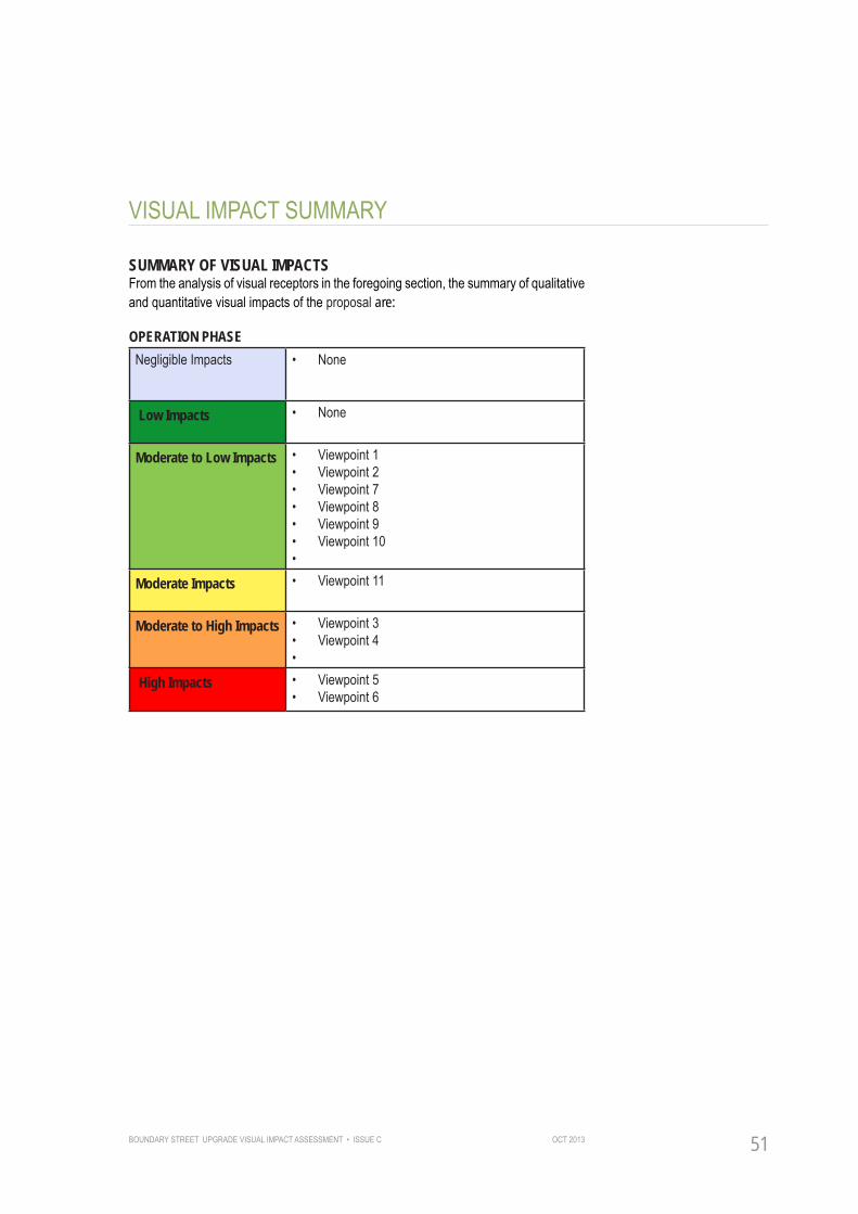
VISUAL IMPACT SUMMARY
SUMMARY OF VISUAL IMPACTSFrom the analysis of visual receptors in the foregoing section, the summary of qualitative and quantitative visual impacts of the proposal are:
OPERATION PHASENegligible Impacts • None
Low Impacts • None
Moderate to Low Impacts • Viewpoint 1 • Viewpoint 2• Viewpoint 7• Viewpoint 8• Viewpoint 9• Viewpoint 10•
Moderate Impacts • Viewpoint 11
Moderate to High Impacts • Viewpoint 3• Viewpoint 4•
High Impacts • Viewpoint 5• Viewpoint 6
MAGNITUDE
RECE
PTOR
SEN
SITI
VITY
RECE
PTOR
TYP
E
RECE
PTOR
ID
ENTI
FICA
TION
PHOT
O LO
CATI
ON
DIST
ANCE
QUAN
TUM
OF V
IEW
DURA
TION
MAGN
ITUD
E OF
CHA
NGE
SUMM
ARY
OF R
ATIN
GS

BOUNDARY STREET UPGRADE VISUAL IMPACT ASSESSMENT • ISSUE COCT 201352
VISUAL IMPACT SUMMARY
OPERATION PHASEOnce Boundary Street has been upgraded, the most visible elements of the scheme will be the new slope or retaining wall to the northern edge of the road, new infrastructure (such as raised medians, signage and signals) and the removal of vegetation alongside the northern and southern edge of the road.
This removal of vegetation will be the most visible element of the proposal, altering the character of the western end of Boundary Street where a dense green, vegetated edge currently defines the northern side of the road.
Post-construction, four viewpoints have recorded an impact rating of ‘Moderate/High’ to ‘High’, whilst the rest are ‘Moderate’ (viewpoint 10) or ‘Moderate/Low’. The properties on the southern edge of Boundary Street (viewpoint 3) will be affected by a noticeable reduction in the level of visual screening between their frontages and the road. This may be mitigated if street tree planting is included within the detailed design.
Five of the properties covered in viewpoint 6 are likely to be re-developed as apartments, decreasing their sensitivity to change and potentially reducing their impact rating from ‘High’ in the future. Road users at the western end of Boundary Street (viewpoint 4) will experience a noticeable change in the character of the road as the green edge is lost on both sides. This has led to a ‘Moderate/High’ impact rating for road users post-construction (refer Figure 05).
CONCLUSIONOverall, the Boundary Street upgrade proposal can be said to be in keeping with the scale and bulk of existing road infrastructure in the area. The changes affect a limited number of properties within the study area.
The future residential character and scale of the area is set to change in the short to mid-term future with density controls permitting a significantly higher density of development on Boundary Street. Single storey properties are likely to be converted to multistory apartment blocks. The street will take on a more urban character, with new residents moving into an already modified visual environment.
The loss of vegetation will be the most noticeable change for road users and the residents that remain. All opportunities should be taken to replace street trees where possible as discussed within the Mitigation section of this report.

BOUNDARY STREET UPGRADE VISUAL IMPACT ASSESSMENT • ISSUE C OCT 2013 53
VISUAL IMPACT SUMMARY
Figure 5 Operation Phase Visual Impacts
Low Impact
Moderate/Low Impact
Moderate/High Impact
High Impact
Pacific Highway
Archer Street
Spearman Street
Hill Street
North Shore Rail Line
1
2
4
7
3
8
6
1
5
9
10
Boun
dary
Stree
t
11 Moderate Impact
L
L
LM/L
M/L
M/L
M/L
M/L
M/L
M/L
M
M M/H
M/H
H
H
H
H
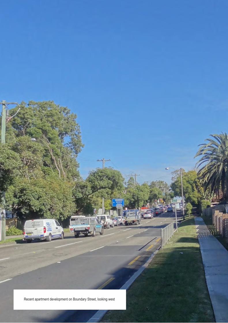
BOUNDARY STREET UPGRADE VISUAL IMPACT ASSESSMENT • ISSUE COCT 201354Recent apartment development on Boundary Street, looking west

BOUNDARY STREET UPGRADE VISUAL IMPACT ASSESSMENT • ISSUE C OCT 2013 55
PART B: MITIGATION
BOUNDARY STREET UPGRADE VISUAL IMPACT ASSESSMENT • ISSUE COCT 201356
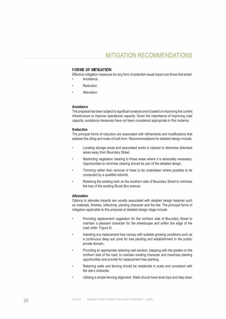
MITIGATION RECOMMENDATIONS
FORMS OF MITIGATIONEffective mitigation measures for any form of potential visual impact are those that entail:• Avoidance.
• Reduction.
• Alleviation.
AvoidanceThe proposal has been subject to significant analysis and is based on improving the current infrastructure to improve operational capacity. Given the importance of improving road capacity, avoidance measures have not been considered appropriate in this instance.
ReductionThe principal forms of reduction are associated with refinements and modifications that address the siting and scale of built form. Recommendations for detailed design include:
• Locating storage areas and associated works in cleared or otherwise disturbed areas away from Boundary Street.
• Restricting vegetation clearing to those areas where it is absolutely necessary. Opportunities to minimise clearing should be part of the detailed design.
• Trimming rather than removal of trees to be undertaken where possible to be conducted by a qualified arborist.
• Retaining the existing kerb on the southern side of Boundary Street to minimise the loss of the existing Brush Box avenue.
AlleviationOptions to alleviate impacts are usually associated with detailed design features such as materials, finishes, reflectivity, planting character and the like. The principal forms of mitigation applicable to this proposal at detailed design stage include:
• Providing replacement vegetation for the northern side of Boundary Street to maintain a pleasant character for the streetscape and soften the edge of the road (refer Figure 6).
• Assisting any replacement tree canopy with suitable growing conditions such as a continuous deep soil zone for tree planting and establishment in the public/private domain.
• Providing an appropriate retaining wall solution, stepping with the grades on the northern side of the road, to maintain existing character and maximise planting opportunities and provide for replacement tree planting.
• Retaining walls and fencing should be residential in scale and consistent with the site’s character.
• Utilising a simple fencing alignment. Walls should have level tops and step down

BOUNDARY STREET UPGRADE VISUAL IMPACT ASSESSMENT • ISSUE C OCT 2013 57
MITIGATION RECOMMENDATIONS
the slope, utilising piers at corners and step changes.
• Considering piered design for retaining wall footings so as to maximise opportunities for the planting trench.
• Integrating driveways with walling and fencing.
• Integrating lighting with the wall design.
• Utilising a small palette of complimentary materials for all surface treatments.
• Providing hedge planting or climbers to retaining walls to improve amenity and reduce surface area that can be impacted by graffiti.
• Reflecting existing vegetation found within the site and local area. Locally prevalent tree species include Jacaranda mimosifolia and Lophostemon confertus.

BOUNDARY STREET UPGRADE VISUAL IMPACT ASSESSMENT • ISSUE COCT 201358
MITIGATION RECOMMENDATIONS
Figure 6 Sketch of potential future development on northern side of Boundary Street
Railway Bridge Future apartment building
Replacement street tree planting to screen buildings behind and provide green edge to road
Retaining wall

BOUNDARY STREET UPGRADE VISUAL IMPACT ASSESSMENT • ISSUE C OCT 2013 59
APPENDIX A - VISUAL IMPACT RATING TABLEAn explanation of the rating categories used to determine the level of visual impact on each viewpoint. These have been developed by CLOUSTON Associates, based on RMS guidance.
SENSITIVITYQualitativeAssessmentDefinitionsReceptor sensitivity
H
M/H
M
M/L
L
Each visual receptor type has an inherent and varied sensitivity to change in the visual scene based on their personal context in which the view is being experienced. This will have a direct bearing on the perception of visual impact experienced by the receptor and qualifies the quantitative impacts:PublicReserve(PD)Parks,Reserves,Publicwalkways:the purpose of visiting and using reserves largely relates to an enhanced sense of wellbeing. Receptor is more sensitive to both positive and negative visual experiences, especially where the reserve is the destination for leisure and relaxation.Residential (R): view from dwelling or garden may be experienced regularly over extended periods of time; residents may have chosen the location specifically for the view and/or develop a strong familiarity and association with the view and have high sensitivity to change. Public Roads/Transport (T): the view experienced can be important to the driver/passenger but is sometimes a brief experience and the driver is usually focused on the road.CommercialProperty(C)-Work:view can enhance the work or education experience but focus of activity is not principally on the view.Semi-Privateproperty(P)-Work/Education/Serviceprovider:view can enhance the work or education experience but focus of activity is not principally on the view.
MAGNITUDEQuantitativeassessmentdefinitionsDistance
HML
The effect the development has on the view relating to the distance between the development and the visual receptor. The distances are from the approximate centre of the site and categorised as:Within 0 - 90 metres- high impact.90 to 500 metres - high to moderate impact.Further than 500 metres - low impact.
Quantum of view
H
M/H
M
M/LLN
The Quantum of view relates to the openness of the view and the angle of the view to the visual receptor. A development located in the direct line of sight has a higher impact than if it were located obliquely at the edge of the view. Whether the view of the development is filtered by vegetation etc. also affects the impact, as does the nature of the view (panoramic, restricted etc.). A small element within a panoramic view has less impact than the same element within a restricted or narrow view. The effects can be categorised as:A direct view of the development or its presence (sometimes in a very narrow or highly framed view), where the development occupies the greater proportion of the view cone.A direct view of the development within a panoramic view where the development occupies a large proportion of the view cone.A direct view of the development or its presence in a broader view where the development occupies a moderate proportion of the view cone.A direct or slightly oblique view of the development within a broad or panoramic view coneAn oblique, highly filtered or largely obscured view of the development.No view of the development site from this location.
Duration
HM/H
M
M/LL
The length of time the visual receptor is exposed to the view. The duration of view affects the impact of the development on the viewer - the longer the exposure the more detailed the impression of the proposed change in terms of visual impact:Significant part of the day - high impact: usually residential property.5 minutes to several hours - high to moderate impact: often from a garden or park or commercial property and work places.10 seconds to 1 minute - moderate impact: usually from a road/driveway entrance, walking past or entrance to commercial property.5 to 10 seconds - moderate to low impact: often from a road or walking past.1 to 5 seconds - low impact: usually from a road or railway

BOUNDARY STREET UPGRADE VISUAL IMPACT ASSESSMENT • ISSUE COCT 201360
APPENDIX A - VISUAL IMPACT RATING TABLE
Magnitude of change
HM/HMM/LLN
Magnitude of change is a quantitative assessment of the change in compositional elements of the view. If the proposed development is largely similar in nature and scale to that of existing elements in the vicinity, the magnitude of change is low. If the development radically changes the nature or composition of the elements in the view, the magnitude of change is high. Distance from the development will accentuate or moderate the scale and variety of visible elements in the overall view and hence influence this rating: Elements within the view will be greatly at odds with existing features in the landscapeElements within the view will be largely at odds with existing features in the landscape Elements within the view will be at odds with existing features in the landscapeElements within the view will be partly at odds with existing features in the landscapeElements and composition of the view will remain largely unaltered .No view of the development from this location.
Summary of Magnitude Ratings
FromH to N
A summary rating that combines all of the quantitative ratings. This is rated either high, moderate to high, moderate, moderate to low, low or none, where none implies no visible change based on the above criteria and high implies significant visible change in terms of the combined quantitative criteria
SUMMARY
Combined Rating
HM/HMM/LLN
The nature of the visual impact may be beneficial or adverse, based on a transparent professional assessment of the combined totals of qualitative and quantitative ratings and comments as outlined above. The final rating is derived using the RMS matrix table - 01:Highly adverse.Moderately to Highly adverse.Moderately adverse.Slightly adverse.Minorly adverseNegligible

BOUNDARY STREET UPGRADE VISUAL IMPACT ASSESSMENT • ISSUE C OCT 2013 61Footpath along northern edge of Boundary Street
CLOUSTON AssociatesLevel 2, 17 Bridge Street • Sydney NSW 2000
PO Box R1388 • Royal Exchange NSW 1225 • AustraliaMobile + 0418 981 869
Telephone +61 2 8272 4999Email • [email protected]