
Annex to ED Decision 2014/022/R - EASA · Annex to ED Decision 2014/022/R ... 010 00 00 00 AIR LAW...
105
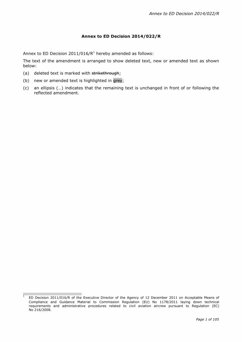
Annex to ED Decision 2014/022/R Page 1 of 105 Annex to ED Decision 2014/022/R Annex to ED Decision 2011/016/R 1 hereby amended as follows: The text of the amendment is arranged to show deleted text, new or amended text as shown below: (a) deleted text is marked with strikethrough; (b) new or amended text is highlighted in grey; (c) an ellipsis (…) indicates that the remaining text is unchanged in front of or following the reflected amendment. 1 ED Decision 2011/016/R of the Executive Director of the Agency of 12 December 2011 on Acceptable Means of Compliance and Guidance Material to Commission Regulation (EU) No 1178/2011 laying down technical requirements and administrative procedures related to civil aviation aircrew pursuant to Regulation (EC) No 216/2008.
Transcript of Annex to ED Decision 2014/022/R - EASA · Annex to ED Decision 2014/022/R ... 010 00 00 00 AIR LAW...
Annex to ED Decision 2014/022/R
Page 1 of 105
Annex to ED Decision 2014/022/R
Annex to ED Decision 2011/016/R1 hereby amended as follows:
The text of the amendment is arranged to show deleted text, new or amended text as shown
below:
(a) deleted text is marked with strikethrough;
(b) new or amended text is highlighted in grey;
(c) an ellipsis (…) indicates that the remaining text is unchanged in front of or following the
reflected amendment.
1 ED Decision 2011/016/R of the Executive Director of the Agency of 12 December 2011 on Acceptable Means of
Compliance and Guidance Material to Commission Regulation (EU) No 1178/2011 laying down technical requirements and administrative procedures related to civil aviation aircrew pursuant to Regulation (EC) No 216/2008.
Page 2 of 105
Subpart A – General requirements
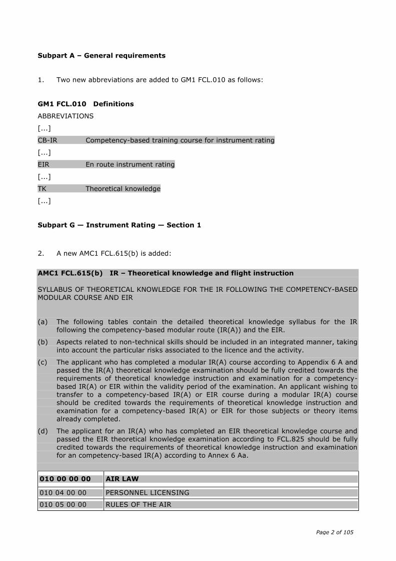
1. Two new abbreviations are added to GM1 FCL.010 as follows:
GM1 FCL.010 Definitions
ABBREVIATIONS
[...]
CB-IR Competency-based training course for instrument rating
[...]
EIR En route instrument rating
[...]
TK Theoretical knowledge
[...]
Subpart G — Instrument Rating — Section 1
2. A new AMC1 FCL.615(b) is added:
AMC1 FCL.615(b) IR – Theoretical knowledge and flight instruction
SYLLABUS OF THEORETICAL KNOWLEDGE FOR THE IR FOLLOWING THE COMPETENCY-BASED
MODULAR COURSE AND EIR
(a) The following tables contain the detailed theoretical knowledge syllabus for the IR
following the competency-based modular route (IR(A)) and the EIR.
(b) Aspects related to non-technical skills should be included in an integrated manner, taking
into account the particular risks associated to the licence and the activity.
(c) The applicant who has completed a modular IR(A) course according to Appendix 6 A and
passed the IR(A) theoretical knowledge examination should be fully credited towards the
requirements of theoretical knowledge instruction and examination for a competency-
based IR(A) or EIR within the validity period of the examination. An applicant wishing to
transfer to a competency-based IR(A) or EIR course during a modular IR(A) course
should be credited towards the requirements of theoretical knowledge instruction and
examination for a competency-based IR(A) or EIR for those subjects or theory items
already completed.
(d) The applicant for an IR(A) who has completed an EIR theoretical knowledge course and
passed the EIR theoretical knowledge examination according to FCL.825 should be fully
credited towards the requirements of theoretical knowledge instruction and examination
for an competency-based IR(A) according to Annex 6 Aa.
010 00 00 00 AIR LAW
010 04 00 00 PERSONNEL LICENSING
010 05 00 00 RULES OF THE AIR
Page 3 of 105
010 06 00 00 PROCEDURES FOR AIR NAVIGATION SERVICES — AIRCRAFT OPERATIONS (PANS OPS)
010 07 00 00 AIR TRAFFIC SERVICES AND AIR TRAFFIC MANAGEMENT
010 08 00 00 AERONAUTICAL INFORMATION SERVICE
010 09 00 00 AERODROMES (ICAO Annex 14, Volume I, Aerodrome Design and Operations)
022 00 00 00 AIRCRAFT GENERAL KNOWLEDGE — INSTRUMENTATION
022 02 00 00 MEASUREMENT OF AIR DATA PARAMETERS
022 04 00 00 GYROSCOPIC INSTRUMENTS
022 13 00 00 INTEGRATED INSTRUMENTS — ELECTRONIC DISPLAYS
033 00 00 00 FLIGHT PLANNING AND MONITORING
033 02 00 00 FLIGHT PLANNING FOR IFR FLIGHTS
033 03 00 00 FUEL PLANNING
033 04 00 00 PRE-FLIGHT PREPARATION
033 05 00 00 ICAO FLIGHT PLAN (ATS FLIGHT PLAN)
040 00 00 00 HUMAN PERFORMANCE
040 01 00 00 HUMAN FACTORS: BASIC CONCEPTS
040 02 00 00 BASIC AVIATION PHYSIOLOGY AND HEALTH MAINTENANCE
040 03 00 00 BASIC AVIATION PSYCHOLOGY
050 00 00 00 METEOROLOGY
050 01 00 00 THE ATMOSPHERE
050 02 00 00 WIND
050 03 00 00 THERMODYNAMICS
050 04 00 00 CLOUDS AND FOG
050 05 00 00 PRECIPITATION
050 06 00 00 AIR MASSES AND FRONTS
050 07 00 00 PRESSURE SYSTEMS
050 08 00 00 CLIMATOLOGY
050 09 00 00 FLIGHT HAZARDS
050 10 00 00 METEOROLOGICAL INFORMATION
062 00 00 00 RADIO NAVIGATION
062 02 00 00 RADIO AIDS
062 03 00 00 RADAR
062 05 00 00 AREA NAVIGATION SYSTEMS, RNAV/FMS
092 00 00 00 IFR COMMUNICATIONS
092 01 00 00 DEFINITIONS
092 02 00 00 GENERAL OPERATING PROCEDURES
092 03 00 00 ACTION REQUIRED TO BE TAKEN IN CASE OF COMMUNICATION FAILURE

Page 4 of 105
092 04 00 00 DISTRESS AND URGENCY PROCEDURES
092 05 00 00 RELEVANT WEATHER INFORMATION TERM
092 06 00 00 GENERAL PRINCIPLES OF VHF PROPAGATION AND ALLOCATION OF FREQUENCIES
092 07 00 00 MORSE CODE
Page 5 of 105
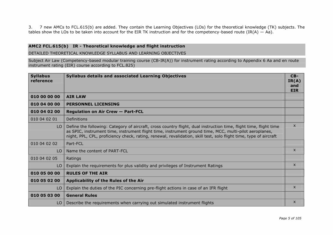
3. 7 new AMCs to FCL.615(b) are added. They contain the Learning Objectives (LOs) for the theoretical knowledge (TK) subjects. The
tables show the LOs to be taken into account for the EIR TK instruction and for the competency-based route (IR(A) — Aa).
AMC2 FCL.615(b) IR - Theoretical knowledge and flight instruction
DETAILED THEORETICAL KNOWLEDGE SYLLABUS AND LEARNING OBJECTIVES
Subject Air Law (Competency-based modular training course (CB-IR(A)) for instrument rating according to Appendix 6 Aa and en route
instrument rating (EIR) course according to FCL.825)
Syllabus
reference
Syllabus details and associated Learning Objectives CB-
IR(A)
and
EIR
010 00 00 00 AIR LAW
010 04 00 00 PERSONNEL LICENSING
010 04 02 00 Regulation on Air Crew — Part-FCL
010 04 02 01 Definitions
LO Define the following: Category of aircraft, cross country flight, dual instruction time, flight time, flight time
as SPIC, instrument time, instrument flight time, instrument ground time, MCC, multi-pilot aeroplanes,
night, PPL, CPL, proficiency check, rating, renewal, revalidation, skill test, solo flight time, type of aircraft
x
010 04 02 02 Part-FCL
LO Name the content of PART-FCL x
010 04 02 05 Ratings
LO Explain the requirements for plus validity and privileges of Instrument Ratings x
010 05 00 00 RULES OF THE AIR
010 05 02 00 Applicability of the Rules of the Air
LO Explain the duties of the PIC concerning pre-flight actions in case of an IFR flight x
010 05 03 00 General Rules
LO Describe the requirements when carrying out simulated instrument flights x
Page 6 of 105
Syllabus
reference
Syllabus details and associated Learning Objectives CB-
IR(A)
and
EIR
LO Explain why a time check has to be obtained before flight x
LO Describe the required actions to be carried out, if the continuation of a controlled VFR flight in VMC is not
practicable anymore
x
LO Describe the provisions for transmitting a position report to the appropriate ATS Unit including time of
transmission and normal content of the message
x
LO Describe the necessary action when an aircraft is experiencing a COM failure x
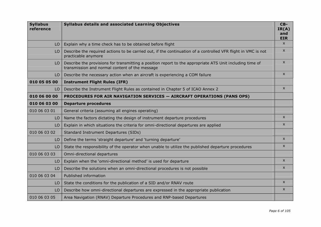
010 05 05 00 Instrument Flight Rules (IFR)
LO Describe the Instrument Flight Rules as contained in Chapter 5 of ICAO Annex 2 x
010 06 00 00 PROCEDURES FOR AIR NAVIGATION SERVICES — AIRCRAFT OPERATIONS (PANS OPS)
010 06 03 00 Departure procedures
010 06 03 01 General criteria (assuming all engines operating)
LO Name the factors dictating the design of instrument departure procedures x
LO Explain in which situations the criteria for omni-directional departures are applied x
010 06 03 02 Standard Instrument Departures (SIDs)
LO Define the terms ‘straight departure’ and ‘turning departure’ x
LO State the responsibility of the operator when unable to utilize the published departure procedures x
010 06 03 03 Omni-directional departures
LO Explain when the ‘omni-directional method’ is used for departure x
LO Describe the solutions when an omni-directional procedures is not possible x
010 06 03 04 Published information
LO State the conditions for the publication of a SID and/or RNAV route x
LO Describe how omni-directional departures are expressed in the appropriate publication x
010 06 03 05 Area Navigation (RNAV) Departure Procedures and RNP-based Departures
Page 7 of 105
Syllabus
reference
Syllabus details and associated Learning Objectives CB-
IR(A)
and
EIR
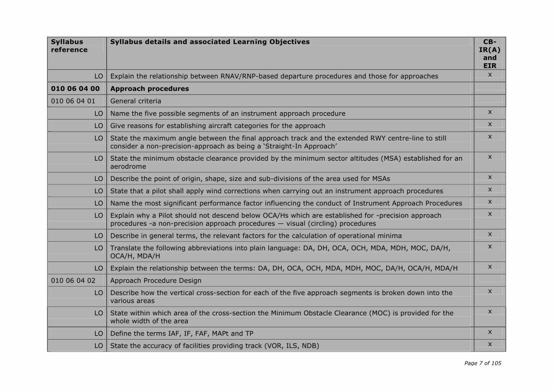
LO Explain the relationship between RNAV/RNP-based departure procedures and those for approaches x
010 06 04 00 Approach procedures
010 06 04 01 General criteria
LO Name the five possible segments of an instrument approach procedure x
LO Give reasons for establishing aircraft categories for the approach x
LO State the maximum angle between the final approach track and the extended RWY centre-line to still
consider a non-precision-approach as being a ‘Straight-In Approach’
x
LO State the minimum obstacle clearance provided by the minimum sector altitudes (MSA) established for an
aerodrome
x
LO Describe the point of origin, shape, size and sub-divisions of the area used for MSAs x
LO State that a pilot shall apply wind corrections when carrying out an instrument approach procedures x
LO Name the most significant performance factor influencing the conduct of Instrument Approach Procedures x
LO Explain why a Pilot should not descend below OCA/Hs which are established for -precision approach
procedures -a non-precision approach procedures — visual (circling) procedures
x
LO Describe in general terms, the relevant factors for the calculation of operational minima x
LO Translate the following abbreviations into plain language: DA, DH, OCA, OCH, MDA, MDH, MOC, DA/H,
OCA/H, MDA/H
x
LO Explain the relationship between the terms: DA, DH, OCA, OCH, MDA, MDH, MOC, DA/H, OCA/H, MDA/H x
010 06 04 02 Approach Procedure Design
LO Describe how the vertical cross-section for each of the five approach segments is broken down into the
various areas
x
LO State within which area of the cross-section the Minimum Obstacle Clearance (MOC) is provided for the
whole width of the area
x
LO Define the terms IAF, IF, FAF, MAPt and TP x
LO State the accuracy of facilities providing track (VOR, ILS, NDB) x
Page 8 of 105
Syllabus
reference
Syllabus details and associated Learning Objectives CB-
IR(A)
and
EIR
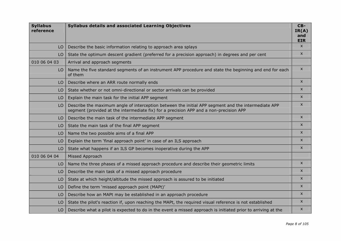
LO Describe the basic information relating to approach area splays x
LO State the optimum descent gradient (preferred for a precision approach) in degrees and per cent x
010 06 04 03 Arrival and approach segments
LO Name the five standard segments of an instrument APP procedure and state the beginning and end for each
of them
x
LO Describe where an ARR route normally ends x
LO State whether or not omni-directional or sector arrivals can be provided x
LO Explain the main task for the initial APP segment x
LO Describe the maximum angle of interception between the initial APP segment and the intermediate APP
segment (provided at the intermediate fix) for a precision APP and a non-precision APP
x
LO Describe the main task of the intermediate APP segment x
LO State the main task of the final APP segment x
LO Name the two possible aims of a final APP x
LO Explain the term ‘final approach point’ in case of an ILS approach x
LO State what happens if an ILS GP becomes inoperative during the APP x
010 06 04 04 Missed Approach
LO Name the three phases of a missed approach procedure and describe their geometric limits x
LO Describe the main task of a missed approach procedure x
LO State at which height/altitude the missed approach is assured to be initiated x
LO Define the term ‘missed approach point (MAPt)’ x
LO Describe how an MAPt may be established in an approach procedure x
LO State the pilot‘s reaction if, upon reaching the MAPt, the required visual reference is not established x
LO Describe what a pilot is expected to do in the event a missed approach is initiated prior to arriving at the x
Page 9 of 105
Syllabus
reference
Syllabus details and associated Learning Objectives CB-
IR(A)
and
EIR
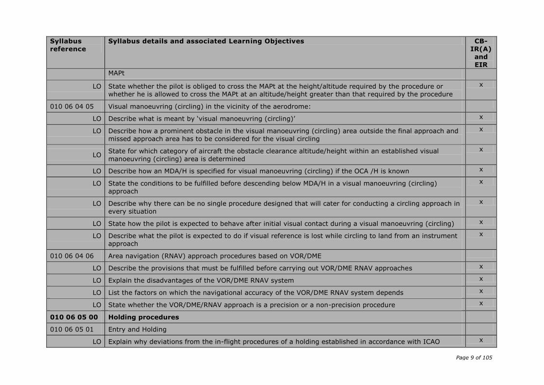
MAPt
LO State whether the pilot is obliged to cross the MAPt at the height/altitude required by the procedure or
whether he is allowed to cross the MAPt at an altitude/height greater than that required by the procedure
x
010 06 04 05 Visual manoeuvring (circling) in the vicinity of the aerodrome:
LO Describe what is meant by ‘visual manoeuvring (circling)’ x
LO Describe how a prominent obstacle in the visual manoeuvring (circling) area outside the final approach and
missed approach area has to be considered for the visual circling
x
LO State for which category of aircraft the obstacle clearance altitude/height within an established visual
manoeuvring (circling) area is determined
x
LO Describe how an MDA/H is specified for visual manoeuvring (circling) if the OCA /H is known x
LO State the conditions to be fulfilled before descending below MDA/H in a visual manoeuvring (circling)
approach
x
LO Describe why there can be no single procedure designed that will cater for conducting a circling approach in
every situation
x
LO State how the pilot is expected to behave after initial visual contact during a visual manoeuvring (circling) x
LO Describe what the pilot is expected to do if visual reference is lost while circling to land from an instrument
approach
x
010 06 04 06 Area navigation (RNAV) approach procedures based on VOR/DME
LO Describe the provisions that must be fulfilled before carrying out VOR/DME RNAV approaches x
LO Explain the disadvantages of the VOR/DME RNAV system x
LO List the factors on which the navigational accuracy of the VOR/DME RNAV system depends x
LO State whether the VOR/DME/RNAV approach is a precision or a non-precision procedure x
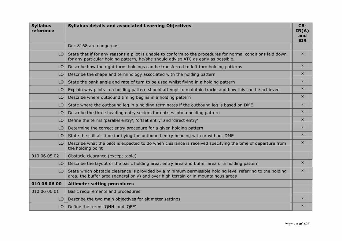
010 06 05 00 Holding procedures
010 06 05 01 Entry and Holding
LO Explain why deviations from the in-flight procedures of a holding established in accordance with ICAO x
Page 10 of 105
Syllabus
reference
Syllabus details and associated Learning Objectives CB-
IR(A)
and
EIR
Doc 8168 are dangerous
LO State that if for any reasons a pilot is unable to conform to the procedures for normal conditions laid down
for any particular holding pattern, he/she should advise ATC as early as possible.
x
LO Describe how the right turns holdings can be transferred to left turn holding patterns x
LO Describe the shape and terminology associated with the holding pattern x
LO State the bank angle and rate of turn to be used whilst flying in a holding pattern x
LO Explain why pilots in a holding pattern should attempt to maintain tracks and how this can be achieved x
LO Describe where outbound timing begins in a holding pattern x
LO State where the outbound leg in a holding terminates if the outbound leg is based on DME x
LO Describe the three heading entry sectors for entries into a holding pattern x
LO Define the terms ‘parallel entry’, ‘offset entry’ and ‘direct entry’ x
LO Determine the correct entry procedure for a given holding pattern x
LO State the still air time for flying the outbound entry heading with or without DME x
LO Describe what the pilot is expected to do when clearance is received specifying the time of departure from
the holding point
x
010 06 05 02 Obstacle clearance (except table)
LO Describe the layout of the basic holding area, entry area and buffer area of a holding pattern x
LO State which obstacle clearance is provided by a minimum permissible holding level referring to the holding
area, the buffer area (general only) and over high terrain or in mountainous areas
x
010 06 06 00 Altimeter setting procedures
010 06 06 01 Basic requirements and procedures
LO Describe the two main objectives for altimeter settings x
LO Define the terms ‘QNH’ and ‘QFE’ x

Page 11 of 105
Syllabus
reference
Syllabus details and associated Learning Objectives CB-
IR(A)
and
EIR
LO Describe the different terms of altitude or flight levels respectively which are the references during climb or
descent to change the altimeter setting from QNH to 1013.2 hPa and vice versa
x
LO Define the term ‘Flight Level’ (FL) x
LO State where flight level zero shall be located x
LO State the interval by which consecutive flight levels shall be separated x
LO Describe how flight levels are numbered x
LO Define the term ‘Transition Altitude’ x
LO State how Transition Altitudes shall normally be specified x
LO Explain how the height of the Transition Altitude is calculated and expressed in practice x
LO State where Transition Altitudes shall be published x
LO Define the term ‘Transition Level’ x
LO State when the Transition Level is normally passed to aircraft x
LO State how the vertical position of aircraft shall be expressed at or below the Transition Altitude and
Transition Level
x
LO Define the term ‘Transition Layer’ x
LO Describe when the vertical position of an aircraft passing through the transition layer shall be expressed in
terms of flight levels and when in terms of altitude
x
LO State when the QNH altimeter setting shall be made available to departing aircraft x
LO Explain when the vertical separation of aircraft during en-route flight shall be assessed in terms of altitude
and when in terms of flight levels
x
LO Explain when, in air-ground communications during an en-route flight, the vertical position of an aircraft
shall be expressed in terms of altitude and when in terms of flight levels
x
LO Describe why QNH altimeter setting reports should be provided from sufficient locations x
LO State how a QNH altimeter setting shall be made available to aircraft approaching a controlled aerodrome x
Page 12 of 105
Syllabus
reference
Syllabus details and associated Learning Objectives CB-
IR(A)
and
EIR
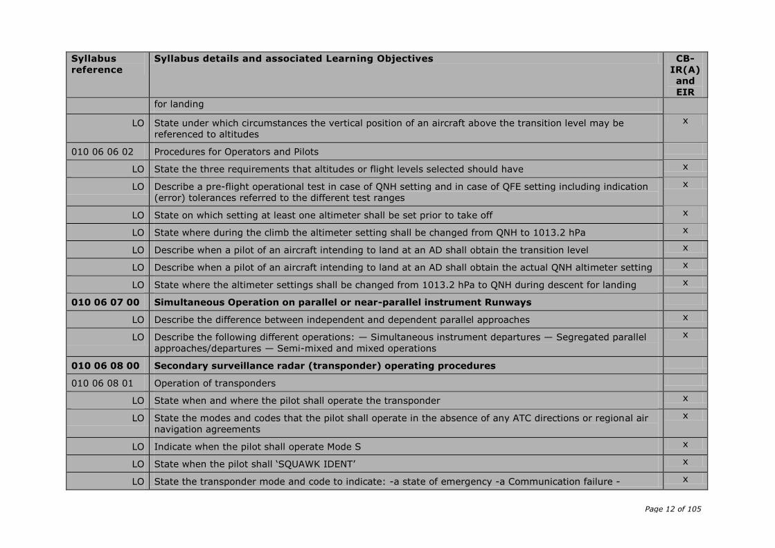
for landing
LO State under which circumstances the vertical position of an aircraft above the transition level may be
referenced to altitudes
x
010 06 06 02 Procedures for Operators and Pilots
LO State the three requirements that altitudes or flight levels selected should have x
LO Describe a pre-flight operational test in case of QNH setting and in case of QFE setting including indication
(error) tolerances referred to the different test ranges
x
LO State on which setting at least one altimeter shall be set prior to take off x
LO State where during the climb the altimeter setting shall be changed from QNH to 1013.2 hPa x
LO Describe when a pilot of an aircraft intending to land at an AD shall obtain the transition level x
LO Describe when a pilot of an aircraft intending to land at an AD shall obtain the actual QNH altimeter setting x
LO State where the altimeter settings shall be changed from 1013.2 hPa to QNH during descent for landing x
010 06 07 00 Simultaneous Operation on parallel or near-parallel instrument Runways
LO Describe the difference between independent and dependent parallel approaches x
LO Describe the following different operations: — Simultaneous instrument departures — Segregated parallel
approaches/departures — Semi-mixed and mixed operations
x
010 06 08 00 Secondary surveillance radar (transponder) operating procedures
010 06 08 01 Operation of transponders
LO State when and where the pilot shall operate the transponder x
LO State the modes and codes that the pilot shall operate in the absence of any ATC directions or regional air
navigation agreements
x
LO Indicate when the pilot shall operate Mode S x
LO State when the pilot shall ‘SQUAWK IDENT’ x
LO State the transponder mode and code to indicate: -a state of emergency -a Communication failure - x
Page 13 of 105
Syllabus
reference
Syllabus details and associated Learning Objectives CB-
IR(A)
and
EIR
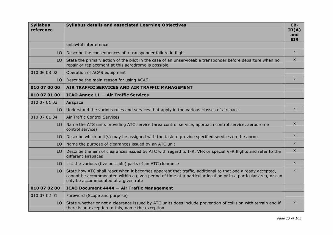
unlawful interference
LO Describe the consequences of a transponder failure in flight x
LO State the primary action of the pilot in the case of an unserviceable transponder before departure when no
repair or replacement at this aerodrome is possible
x
010 06 08 02 Operation of ACAS equipment
LO Describe the main reason for using ACAS x
010 07 00 00 AIR TRAFFIC SERVICES AND AIR TRAFFIC MANAGEMENT
010 07 01 00 ICAO Annex 11 — Air Traffic Services
010 07 01 03 Airspace
LO Understand the various rules and services that apply in the various classes of airspace x
010 07 01 04 Air Traffic Control Services
LO Name the ATS units providing ATC service (area control service, approach control service, aerodrome
control service)
x
LO Describe which unit(s) may be assigned with the task to provide specified services on the apron x
LO Name the purpose of clearances issued by an ATC unit x
LO Describe the aim of clearances issued by ATC with regard to IFR, VFR or special VFR flights and refer to the
different airspaces
x
LO List the various (five possible) parts of an ATC clearance x
LO State how ATC shall react when it becomes apparent that traffic, additional to that one already accepted,
cannot be accommodated within a given period of time at a particular location or in a particular area, or can
only be accommodated at a given rate
x
010 07 02 00 ICAO Document 4444 — Air Traffic Management
010 07 02 01 Foreword (Scope and purpose)
LO State whether or not a clearance issued by ATC units does include prevention of collision with terrain and if
there is an exception to this, name the exception
x

Page 14 of 105
Syllabus
reference
Syllabus details and associated Learning Objectives CB-
IR(A)
and
EIR
010 07 02 03 ATS System Capacity and Air Traffic Flow Management
LO Explain when and where an air traffic flow management (ATFM) service shall be implemented x
010 07 02 05 ATC Clearances
LO Explain ‘the sole scope and purpose’ of an ATC clearance x
LO State on which information the issue of an ATC clearance is based x
LO Describe what a PIC should do if an ATC clearance is not suitable x
LO Indicate who bears the responsibility for maintaining applicable rules and regulations whilst flying under the
control of an ATC unit
x
LO Explain what is meant by the expression ‘clearance limit’ x
LO Explain the meaning of the phrases ‘cleared via flight planned route’, ‘cleared via (designation) departure’
and ‘cleared via (designation) arrival’ in an ATC clearance.
x
LO List which items of an ATC clearance shall always be read back by the flight crew x
010 07 02 06 Horizontal Speed Control Instructions
LO Explain the reason for speed control by ATC x
LO Define the maximum speed changes that ATC may impose x
LO State within which distance from the threshold the PIC must not expect any kind of speed control x
010 07 02 07 Change from IFR to VFR flight
LO Explain how the change from IFR to VFR can be initiated by the PIC x
LO Indicate the expected reaction of the appropriate ATC unit upon a request to change from IFR to VFR x
010 07 02 09 Altimeter Setting Procedures
LO Define the following terms: — transition level — transition layer — and transition altitude x
LO Indicate how the vertical position of an aircraft in the vicinity of an aerodrome shall be expressed at or
below the transition altitude, at or above the transition level and while climbing or descending through the
transition layer
x
Page 15 of 105
Syllabus
reference
Syllabus details and associated Learning Objectives CB-
IR(A)
and
EIR
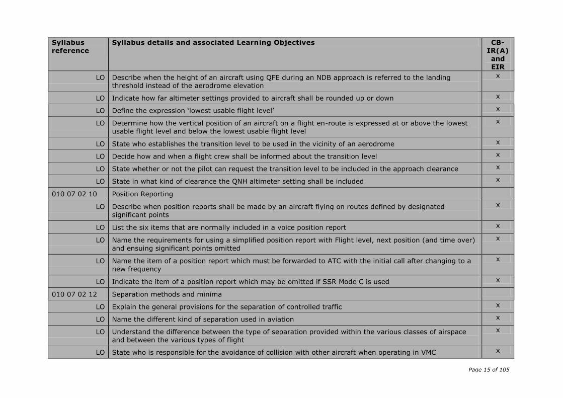
LO Describe when the height of an aircraft using QFE during an NDB approach is referred to the landing
threshold instead of the aerodrome elevation
x
LO Indicate how far altimeter settings provided to aircraft shall be rounded up or down x
LO Define the expression ‘lowest usable flight level’ x
LO Determine how the vertical position of an aircraft on a flight en-route is expressed at or above the lowest
usable flight level and below the lowest usable flight level
x
LO State who establishes the transition level to be used in the vicinity of an aerodrome x
LO Decide how and when a flight crew shall be informed about the transition level x
LO State whether or not the pilot can request the transition level to be included in the approach clearance x
LO State in what kind of clearance the QNH altimeter setting shall be included x
010 07 02 10 Position Reporting
LO Describe when position reports shall be made by an aircraft flying on routes defined by designated
significant points
x
LO List the six items that are normally included in a voice position report x
LO Name the requirements for using a simplified position report with Flight level, next position (and time over)
and ensuing significant points omitted
x
LO Name the item of a position report which must be forwarded to ATC with the initial call after changing to a
new frequency
x
LO Indicate the item of a position report which may be omitted if SSR Mode C is used x
010 07 02 12 Separation methods and minima
LO Explain the general provisions for the separation of controlled traffic x
LO Name the different kind of separation used in aviation x
LO Understand the difference between the type of separation provided within the various classes of airspace
and between the various types of flight
x
LO State who is responsible for the avoidance of collision with other aircraft when operating in VMC x

Page 16 of 105
Syllabus
reference
Syllabus details and associated Learning Objectives CB-
IR(A)
and
EIR
LO State the ICAO documents in which details of current separation minima are prescribed x
LO Describe how vertical separation is obtained x
LO State the required vertical separation minimum x
LO Describe how the cruising levels of aircraft flying to the same destination and the expected approach
sequence are correlated with each other
x
LO Name the conditions that must be adhered to, when two aircraft are cleared to maintain a specified vertical
separation between them during climb or descent
x
LO List the two main methods for horizontal separation x
LO Describe how lateral separation of aircraft at the same level may be obtained x
LO Explain the term ‘Geographical Separation’ x
LO Describe track separation between aircraft using the same navigation aid or method x
LO Describe the three basic means for the establishment of longitudinal separation x
LO Describe the circumstances under which a reduction in separation minima may be allowed x
LO Indicate the standard horizontal radar separation in NM x
LO State the wake turbulence radar separation for aircraft in the APP and DEP phases of a flight when an
aircraft is operating directly behind another aircraft at the same ALT or less than 300 m (1 000 ft) below
x
010 07 02 13 Separation in the vicinity of aerodromes
LO State the condition to enable ATC to initiate a visual approach for an IFR flight x
LO Indicate whether or not separation will be provided by ATC between an aircraft executing a visual approach
and other arriving or departing aircraft
x
LO State in which case when the flight crew are not familiar with the instrument approach procedure being
carried out, that only the final approach track has to be forwarded to them by ATC
x
LO Describe which flight level should be assigned to an aircraft first arriving over a holding fix for landing x
LO Talk about the priority that will be given to aircraft for a landing x
Page 17 of 105
Syllabus
reference
Syllabus details and associated Learning Objectives CB-
IR(A)
and
EIR
LO Understand the situation when a pilot of an aircraft in an approach sequence indicates his intention to hold
for weather improvements
x
LO Explain the term ‘Expected Approach Time’ and the procedures for its use x
LO State the reasons which could probably lead to the decision to use another take-off or landing direction
than the one into the wind
x
LO Name the possible consequences for a PIC if the ‘RWY-in-use’ is not considered suitable for the operation
involved
x
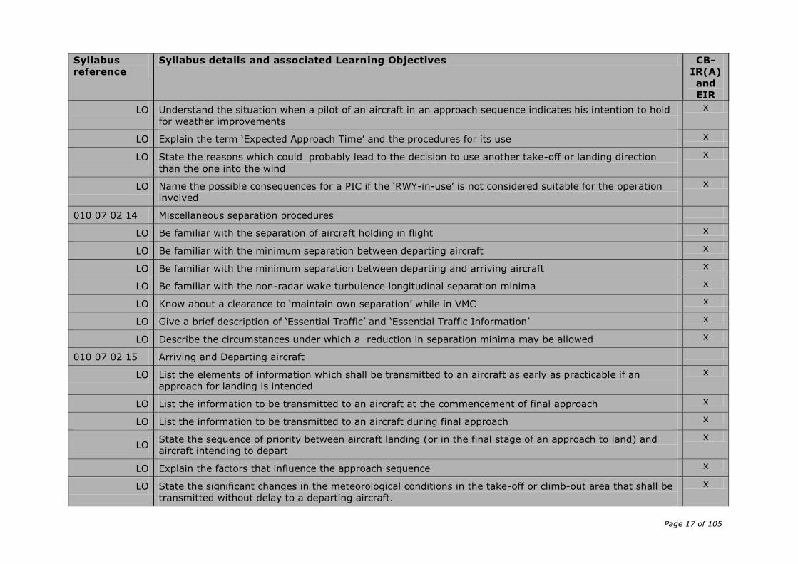
010 07 02 14 Miscellaneous separation procedures
LO Be familiar with the separation of aircraft holding in flight x
LO Be familiar with the minimum separation between departing aircraft x
LO Be familiar with the minimum separation between departing and arriving aircraft x
LO Be familiar with the non-radar wake turbulence longitudinal separation minima x
LO Know about a clearance to ‘maintain own separation’ while in VMC x
LO Give a brief description of ‘Essential Traffic’ and ‘Essential Traffic Information’ x
LO Describe the circumstances under which a reduction in separation minima may be allowed x
010 07 02 15 Arriving and Departing aircraft
LO List the elements of information which shall be transmitted to an aircraft as early as practicable if an
approach for landing is intended
x
LO List the information to be transmitted to an aircraft at the commencement of final approach x
LO List the information to be transmitted to an aircraft during final approach x
LO State the sequence of priority between aircraft landing (or in the final stage of an approach to land) and
aircraft intending to depart
x
LO Explain the factors that influence the approach sequence x
LO State the significant changes in the meteorological conditions in the take-off or climb-out area that shall be
transmitted without delay to a departing aircraft.
x

Page 18 of 105
Syllabus
reference
Syllabus details and associated Learning Objectives CB-
IR(A)
and
EIR
LO Describe what information shall be forwarded to a departing aircraft as far as visual or non-visual aids are
concerned
x
LO State the significant changes that shall be transmitted as early as practicable to an arriving aircraft,
particularly changes in the meteorological conditions.
x
010 07 02 16 Procedures for Aerodrome Control Service
LO Describe the general tasks of the Aerodrome Control Tower (TWR) when issuing information and clearances
to aircraft under its control
x
LO List for which aircraft and their given positions or flight situations the TWR shall prevent collisions x
LO Name the operational failure or irregularity of AD equipment which shall be reported to the TWR
immediately
x
LO State that, after a given period of time, the TWR shall report to the ACC or FIC if an aircraft does not land
as expected
x
LO Describe the procedures to be observed by the TWR whenever VFR operations are suspended x
010 07 02 17 Radar services
LO State to what extent the use of radar in air traffic services may be limited x
LO State what radar derived information shall be available for display to the controller as a minimum x
LO Name the two basic identification procedures used with radar x
LO Define the term ‘PSR’ x
LO Describe the circumstances under which an aircraft provided with radar service should be informed of its
position
x
LO List the possible forms of position information passed to the aircraft by radar services x
LO Define the term ‘radar vectoring’ x
LO State the aims of radar vectoring as shown in ICAO Doc 4444 x
LO State how radar vectoring shall be achieved x
LO Describe the information which shall be given to an aircraft when radar vectoring is terminated and the pilot x
Page 19 of 105
Syllabus
reference
Syllabus details and associated Learning Objectives CB-
IR(A)
and
EIR
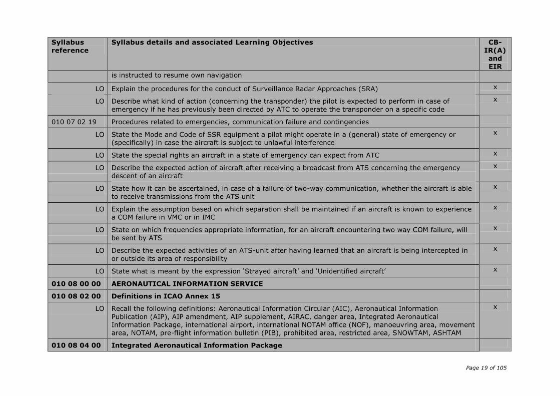
is instructed to resume own navigation
LO Explain the procedures for the conduct of Surveillance Radar Approaches (SRA) x
LO Describe what kind of action (concerning the transponder) the pilot is expected to perform in case of
emergency if he has previously been directed by ATC to operate the transponder on a specific code
x
010 07 02 19 Procedures related to emergencies, communication failure and contingencies
LO State the Mode and Code of SSR equipment a pilot might operate in a (general) state of emergency or
(specifically) in case the aircraft is subject to unlawful interference
x
LO State the special rights an aircraft in a state of emergency can expect from ATC x
LO Describe the expected action of aircraft after receiving a broadcast from ATS concerning the emergency
descent of an aircraft
x
LO State how it can be ascertained, in case of a failure of two-way communication, whether the aircraft is able
to receive transmissions from the ATS unit
x
LO Explain the assumption based on which separation shall be maintained if an aircraft is known to experience
a COM failure in VMC or in IMC
x
LO State on which frequencies appropriate information, for an aircraft encountering two way COM failure, will
be sent by ATS
x
LO Describe the expected activities of an ATS-unit after having learned that an aircraft is being intercepted in
or outside its area of responsibility
x
LO State what is meant by the expression ‘Strayed aircraft’ and ‘Unidentified aircraft’ x
010 08 00 00 AERONAUTICAL INFORMATION SERVICE
010 08 02 00 Definitions in ICAO Annex 15
LO Recall the following definitions: Aeronautical Information Circular (AIC), Aeronautical Information
Publication (AIP), AIP amendment, AIP supplement, AIRAC, danger area, Integrated Aeronautical
Information Package, international airport, international NOTAM office (NOF), manoeuvring area, movement
area, NOTAM, pre-flight information bulletin (PIB), prohibited area, restricted area, SNOWTAM, ASHTAM
x
010 08 04 00 Integrated Aeronautical Information Package
Page 20 of 105
Syllabus
reference
Syllabus details and associated Learning Objectives CB-
IR(A)
and
EIR
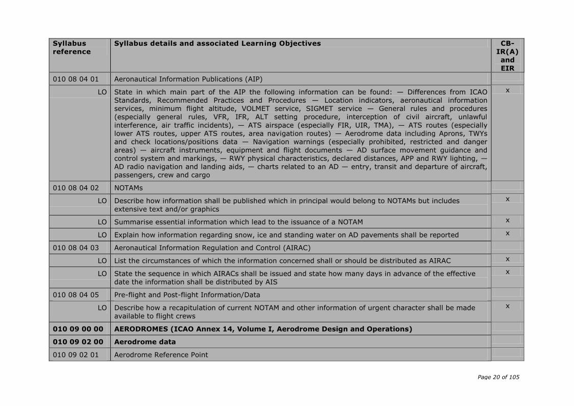
010 08 04 01 Aeronautical Information Publications (AIP)
LO State in which main part of the AIP the following information can be found: — Differences from ICAO
Standards, Recommended Practices and Procedures — Location indicators, aeronautical information
services, minimum flight altitude, VOLMET service, SIGMET service — General rules and procedures
(especially general rules, VFR, IFR, ALT setting procedure, interception of civil aircraft, unlawful
interference, air traffic incidents), — ATS airspace (especially FIR, UIR, TMA), — ATS routes (especially
lower ATS routes, upper ATS routes, area navigation routes) — Aerodrome data including Aprons, TWYs
and check locations/positions data — Navigation warnings (especially prohibited, restricted and danger
areas) — aircraft instruments, equipment and flight documents — AD surface movement guidance and
control system and markings, — RWY physical characteristics, declared distances, APP and RWY lighting, —
AD radio navigation and landing aids, — charts related to an AD — entry, transit and departure of aircraft,
passengers, crew and cargo
x
010 08 04 02 NOTAMs
LO Describe how information shall be published which in principal would belong to NOTAMs but includes
extensive text and/or graphics
x
LO Summarise essential information which lead to the issuance of a NOTAM x
LO Explain how information regarding snow, ice and standing water on AD pavements shall be reported x
010 08 04 03 Aeronautical Information Regulation and Control (AIRAC)
LO List the circumstances of which the information concerned shall or should be distributed as AIRAC x
LO State the sequence in which AIRACs shall be issued and state how many days in advance of the effective
date the information shall be distributed by AIS
x
010 08 04 05 Pre-flight and Post-flight Information/Data
LO Describe how a recapitulation of current NOTAM and other information of urgent character shall be made
available to flight crews
x
010 09 00 00 AERODROMES (ICAO Annex 14, Volume I, Aerodrome Design and Operations)
010 09 02 00 Aerodrome data
010 09 02 01 Aerodrome Reference Point
Page 21 of 105
Syllabus
reference
Syllabus details and associated Learning Objectives CB-
IR(A)
and
EIR
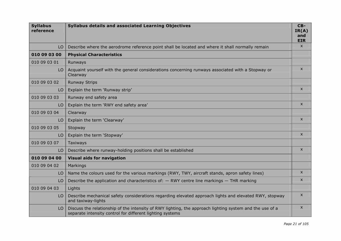
LO Describe where the aerodrome reference point shall be located and where it shall normally remain x
010 09 03 00 Physical Characteristics
010 09 03 01 Runways
LO Acquaint yourself with the general considerations concerning runways associated with a Stopway or
Clearway
x
010 09 03 02 Runway Strips
LO Explain the term ‘Runway strip’ x
010 09 03 03 Runway end safety area
LO Explain the term ‘RWY end safety area’ x
010 09 03 04 Clearway
LO Explain the term ‘Clearway’ x
010 09 03 05 Stopway
LO Explain the term ‘Stopway’ x
010 09 03 07 Taxiways
LO Describe where runway-holding positions shall be established x
010 09 04 00 Visual aids for navigation
010 09 04 02 Markings
LO Name the colours used for the various markings (RWY, TWY, aircraft stands, apron safety lines) x
LO Describe the application and characteristics of: — RWY centre line markings — THR marking x
010 09 04 03 Lights
LO Describe mechanical safety considerations regarding elevated approach lights and elevated RWY, stopway
and taxiway-lights
x
LO Discuss the relationship of the intensity of RWY lighting, the approach lighting system and the use of a
separate intensity control for different lighting systems
x
Page 22 of 105
Syllabus
reference
Syllabus details and associated Learning Objectives CB-
IR(A)
and
EIR
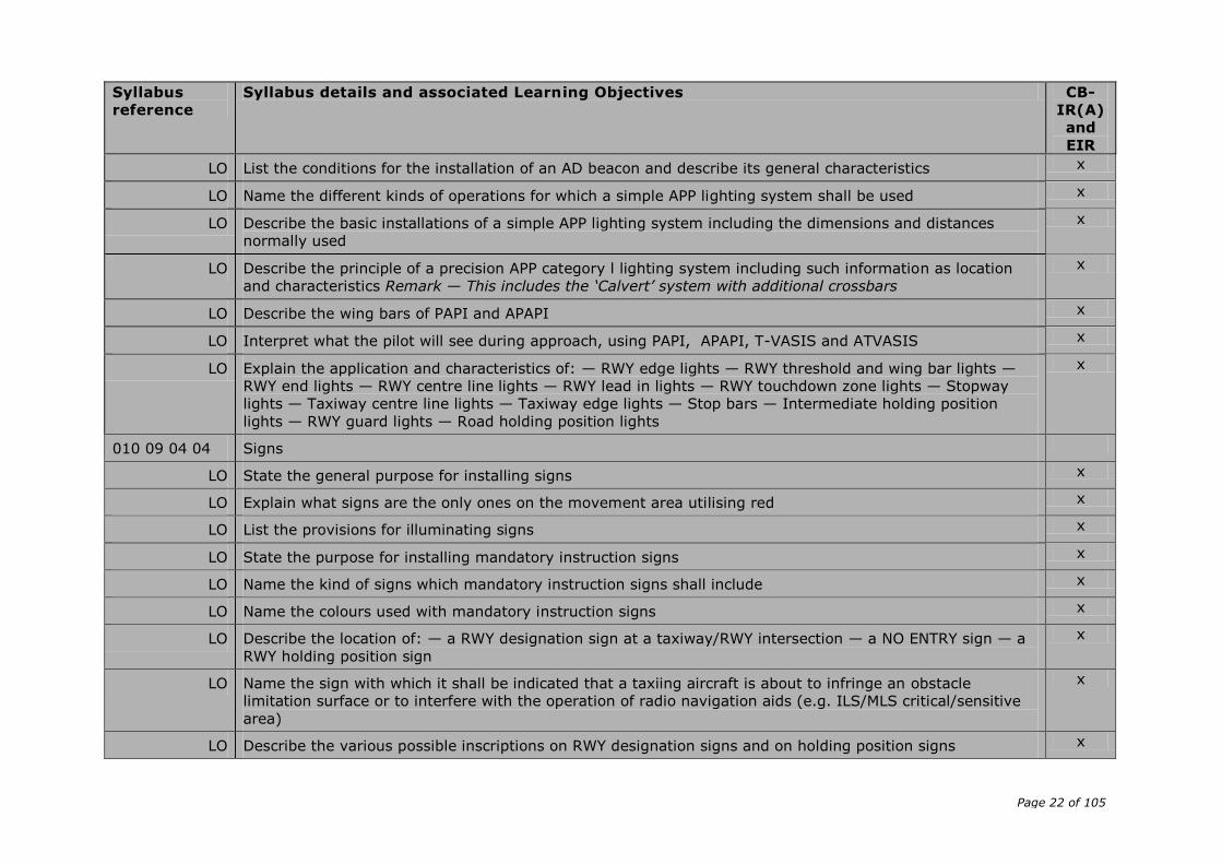
LO List the conditions for the installation of an AD beacon and describe its general characteristics x
LO Name the different kinds of operations for which a simple APP lighting system shall be used x
LO Describe the basic installations of a simple APP lighting system including the dimensions and distances
normally used
x
LO Describe the principle of a precision APP category l lighting system including such information as location
and characteristics Remark — This includes the ‘Calvert’ system with additional crossbars
x
LO Describe the wing bars of PAPI and APAPI x
LO Interpret what the pilot will see during approach, using PAPI, APAPI, T-VASIS and ATVASIS x
LO Explain the application and characteristics of: — RWY edge lights — RWY threshold and wing bar lights —
RWY end lights — RWY centre line lights — RWY lead in lights — RWY touchdown zone lights — Stopway
lights — Taxiway centre line lights — Taxiway edge lights — Stop bars — Intermediate holding position
lights — RWY guard lights — Road holding position lights
x
010 09 04 04 Signs
LO State the general purpose for installing signs x
LO Explain what signs are the only ones on the movement area utilising red x
LO List the provisions for illuminating signs x
LO State the purpose for installing mandatory instruction signs x
LO Name the kind of signs which mandatory instruction signs shall include x
LO Name the colours used with mandatory instruction signs x
LO Describe the location of: — a RWY designation sign at a taxiway/RWY intersection — a NO ENTRY sign — a
RWY holding position sign
x
LO Name the sign with which it shall be indicated that a taxiing aircraft is about to infringe an obstacle
limitation surface or to interfere with the operation of radio navigation aids (e.g. ILS/MLS critical/sensitive
area)
x
LO Describe the various possible inscriptions on RWY designation signs and on holding position signs x
Page 23 of 105
Syllabus
reference
Syllabus details and associated Learning Objectives CB-
IR(A)
and
EIR
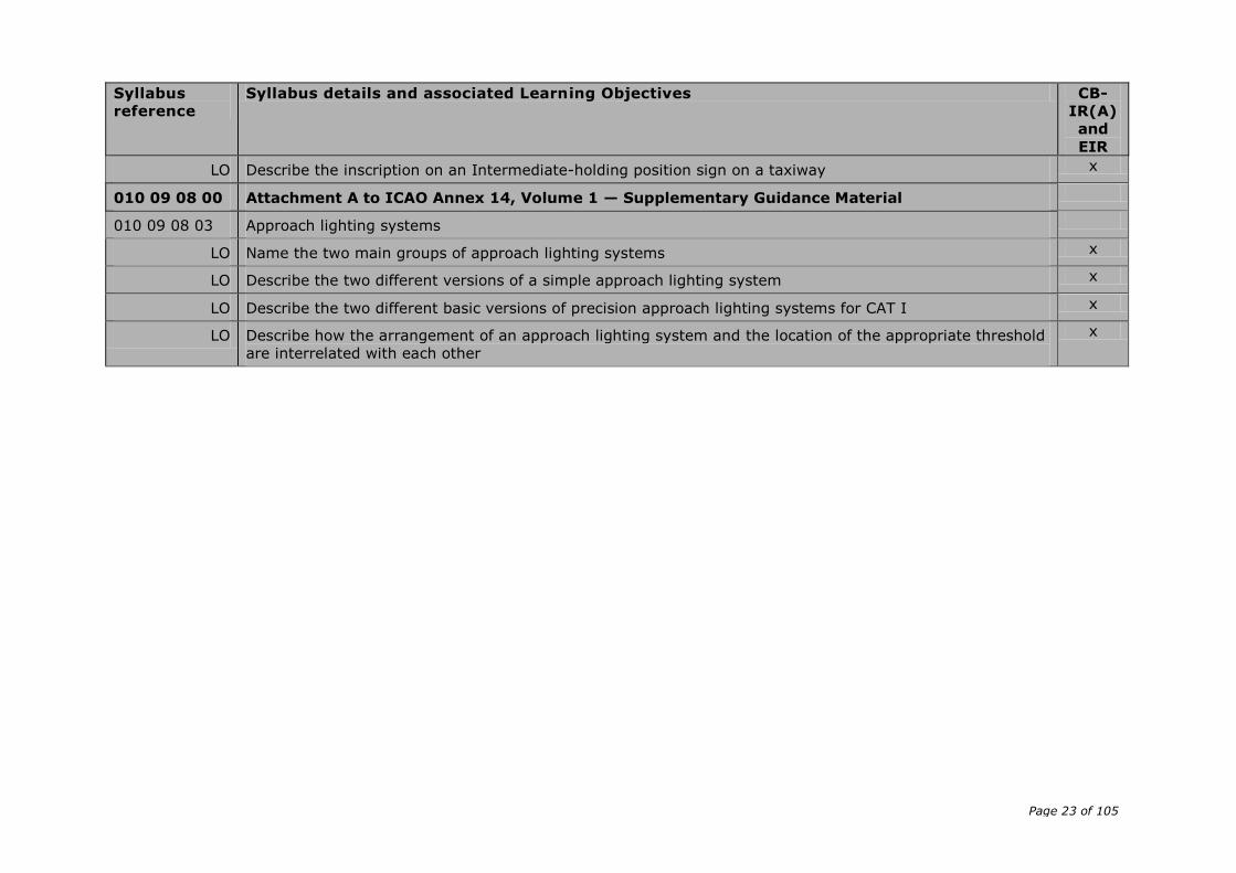
LO Describe the inscription on an Intermediate-holding position sign on a taxiway x
010 09 08 00 Attachment A to ICAO Annex 14, Volume 1 — Supplementary Guidance Material
010 09 08 03 Approach lighting systems
LO Name the two main groups of approach lighting systems x
LO Describe the two different versions of a simple approach lighting system x
LO Describe the two different basic versions of precision approach lighting systems for CAT I x
LO Describe how the arrangement of an approach lighting system and the location of the appropriate threshold
are interrelated with each other
x
Page 24 of 105
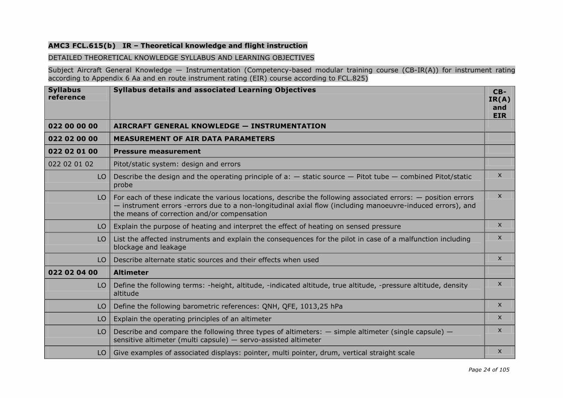
AMC3 FCL.615(b) IR – Theoretical knowledge and flight instruction
DETAILED THEORETICAL KNOWLEDGE SYLLABUS AND LEARNING OBJECTIVES
Subject Aircraft General Knowledge — Instrumentation (Competency-based modular training course (CB-IR(A)) for instrument rating
according to Appendix 6 Aa and en route instrument rating (EIR) course according to FCL.825)
Syllabus reference
Syllabus details and associated Learning Objectives CB-IR(A)
and
EIR
022 00 00 00 AIRCRAFT GENERAL KNOWLEDGE — INSTRUMENTATION
022 02 00 00 MEASUREMENT OF AIR DATA PARAMETERS
022 02 01 00 Pressure measurement
022 02 01 02 Pitot/static system: design and errors
LO Describe the design and the operating principle of a: — static source — Pitot tube — combined Pitot/static
probe
x
LO For each of these indicate the various locations, describe the following associated errors: — position errors
— instrument errors -errors due to a non-longitudinal axial flow (including manoeuvre-induced errors), and
the means of correction and/or compensation
x
LO Explain the purpose of heating and interpret the effect of heating on sensed pressure x
LO List the affected instruments and explain the consequences for the pilot in case of a malfunction including
blockage and leakage
x
LO Describe alternate static sources and their effects when used x
022 02 04 00 Altimeter
LO Define the following terms: -height, altitude, -indicated altitude, true altitude, -pressure altitude, density
altitude
x
LO Define the following barometric references: QNH, QFE, 1013,25 hPa x
LO Explain the operating principles of an altimeter x
LO Describe and compare the following three types of altimeters: — simple altimeter (single capsule) —
sensitive altimeter (multi capsule) — servo-assisted altimeter
x
LO Give examples of associated displays: pointer, multi pointer, drum, vertical straight scale x
Page 25 of 105
Syllabus reference
Syllabus details and associated Learning Objectives CB-IR(A)
and
EIR
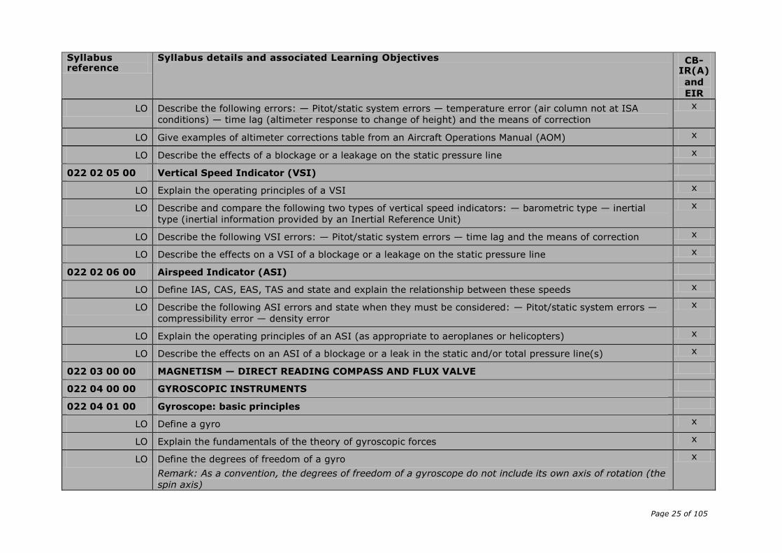
LO Describe the following errors: — Pitot/static system errors — temperature error (air column not at ISA
conditions) — time lag (altimeter response to change of height) and the means of correction
x
LO Give examples of altimeter corrections table from an Aircraft Operations Manual (AOM) x
LO Describe the effects of a blockage or a leakage on the static pressure line x
022 02 05 00 Vertical Speed Indicator (VSI)
LO Explain the operating principles of a VSI x
LO Describe and compare the following two types of vertical speed indicators: — barometric type — inertial
type (inertial information provided by an Inertial Reference Unit)
x
LO Describe the following VSI errors: — Pitot/static system errors — time lag and the means of correction x
LO Describe the effects on a VSI of a blockage or a leakage on the static pressure line x
022 02 06 00 Airspeed Indicator (ASI)
LO Define IAS, CAS, EAS, TAS and state and explain the relationship between these speeds x
LO Describe the following ASI errors and state when they must be considered: — Pitot/static system errors —
compressibility error — density error
x
LO Explain the operating principles of an ASI (as appropriate to aeroplanes or helicopters) x
LO Describe the effects on an ASI of a blockage or a leak in the static and/or total pressure line(s) x
022 03 00 00 MAGNETISM — DIRECT READING COMPASS AND FLUX VALVE
022 04 00 00 GYROSCOPIC INSTRUMENTS
022 04 01 00 Gyroscope: basic principles
LO Define a gyro x
LO Explain the fundamentals of the theory of gyroscopic forces x
LO Define the degrees of freedom of a gyro
Remark: As a convention, the degrees of freedom of a gyroscope do not include its own axis of rotation (the
spin axis)
x
Page 26 of 105
Syllabus reference
Syllabus details and associated Learning Objectives CB-IR(A)
and
EIR
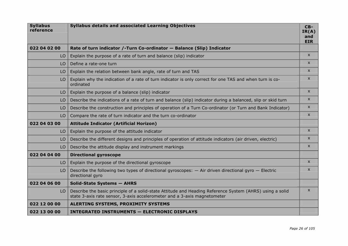
022 04 02 00 Rate of turn indicator /-Turn Co-ordinator — Balance (Slip) Indicator
LO Explain the purpose of a rate of turn and balance (slip) indicator x
LO Define a rate-one turn x
LO Explain the relation between bank angle, rate of turn and TAS x
LO Explain why the indication of a rate of turn indicator is only correct for one TAS and when turn is co-
ordinated
x
LO Explain the purpose of a balance (slip) indicator x
LO Describe the indications of a rate of turn and balance (slip) indicator during a balanced, slip or skid turn x
LO Describe the construction and principles of operation of a Turn Co-ordinator (or Turn and Bank Indicator) x
LO Compare the rate of turn indicator and the turn co-ordinator x
022 04 03 00 Attitude Indicator (Artificial Horizon)
LO Explain the purpose of the attitude indicator x
LO Describe the different designs and principles of operation of attitude indicators (air driven, electric) x
LO Describe the attitude display and instrument markings x
022 04 04 00 Directional gyroscope
LO Explain the purpose of the directional gyroscope x
LO Describe the following two types of directional gyroscopes: — Air driven directional gyro — Electric
directional gyro
x
022 04 06 00 Solid-State Systems — AHRS
LO Describe the basic principle of a solid-state Attitude and Heading Reference System (AHRS) using a solid
state 3-axis rate sensor, 3-axis accelerometer and a 3-axis magnetometer
x
022 12 00 00 ALERTING SYSTEMS, PROXIMITY SYSTEMS
022 13 00 00 INTEGRATED INSTRUMENTS — ELECTRONIC DISPLAYS
Page 27 of 105
Syllabus reference
Syllabus details and associated Learning Objectives CB-IR(A)
and
EIR
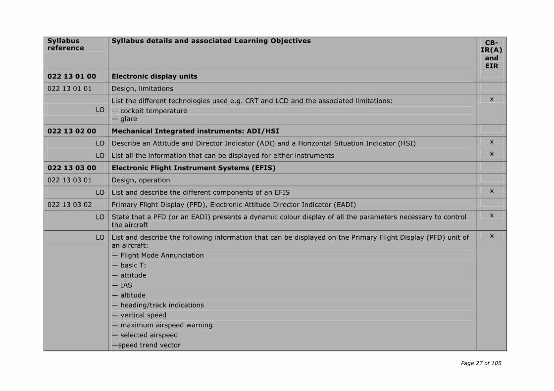
022 13 01 00 Electronic display units
022 13 01 01 Design, limitations
LO
List the different technologies used e.g. CRT and LCD and the associated limitations:
— cockpit temperature
— glare
x
022 13 02 00 Mechanical Integrated instruments: ADI/HSI
LO Describe an Attitude and Director Indicator (ADI) and a Horizontal Situation Indicator (HSI) x
LO List all the information that can be displayed for either instruments x
022 13 03 00 Electronic Flight Instrument Systems (EFIS)
022 13 03 01 Design, operation
LO List and describe the different components of an EFIS x
022 13 03 02 Primary Flight Display (PFD), Electronic Attitude Director Indicator (EADI)
LO State that a PFD (or an EADI) presents a dynamic colour display of all the parameters necessary to control
the aircraft
x
LO List and describe the following information that can be displayed on the Primary Flight Display (PFD) unit of
an aircraft:
— Flight Mode Annunciation
— basic T:
— attitude
— IAS
— altitude
— heading/track indications
— vertical speed
— maximum airspeed warning
— selected airspeed
—speed trend vector
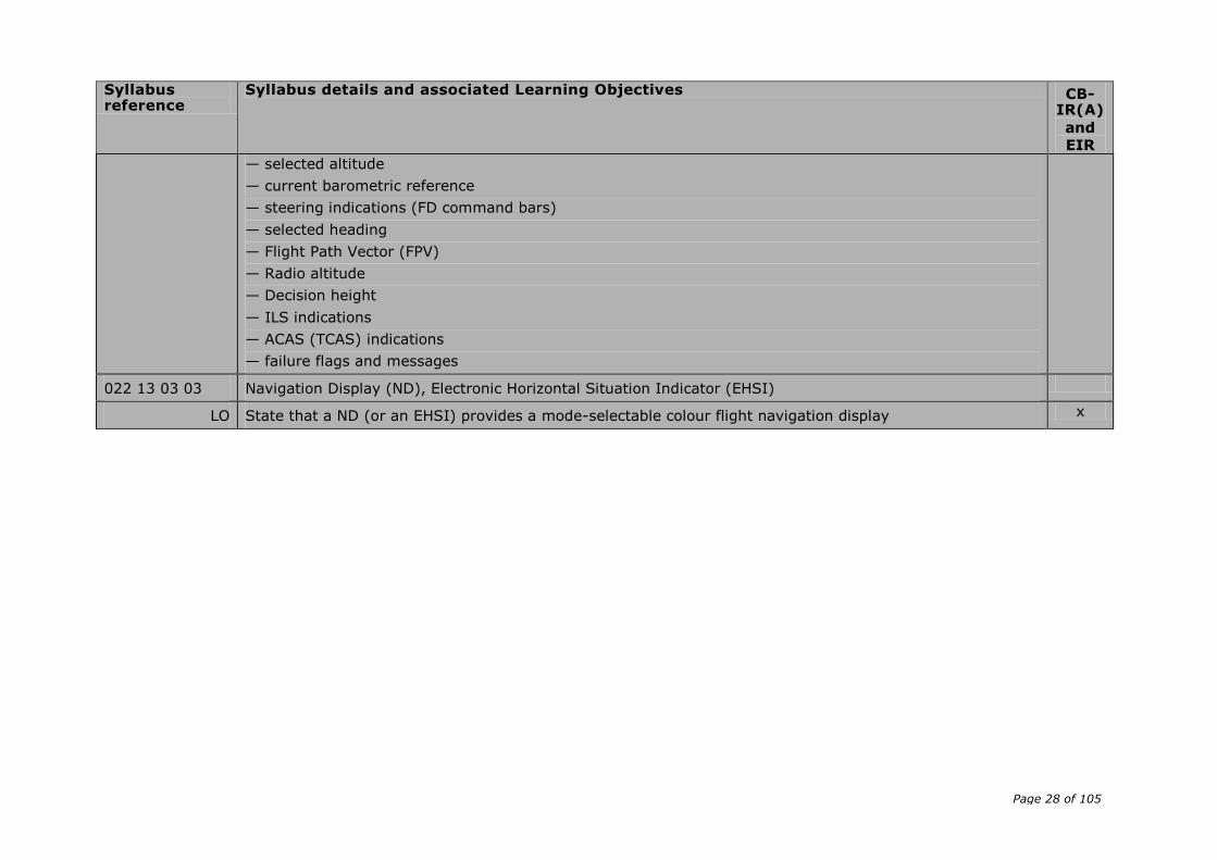
x
Page 28 of 105
Syllabus reference
Syllabus details and associated Learning Objectives CB-IR(A)
and
EIR
— selected altitude
— current barometric reference
— steering indications (FD command bars)
— selected heading
— Flight Path Vector (FPV)
— Radio altitude
— Decision height
— ILS indications
— ACAS (TCAS) indications
— failure flags and messages
022 13 03 03 Navigation Display (ND), Electronic Horizontal Situation Indicator (EHSI)
LO State that a ND (or an EHSI) provides a mode-selectable colour flight navigation display x
Page 29 of 105
AMC4 FCL.615(b) IR – Theoretical knowledge and flight instruction
DETAILED THEORETICAL KNOWLEDGE SYLLABUS AND LEARNING OBJECTIVES
Subject Flight Planning and Flight Monitoring (Competency-based modular training course (CB-IR(A)) for instrument rating according to Appendix 6 Aa and en route instrument (EIR) rating course according to FCL.825)
Syllabus
reference
Syllabus details and associated Learning Objectives CB-
IR(A)
and
EIR
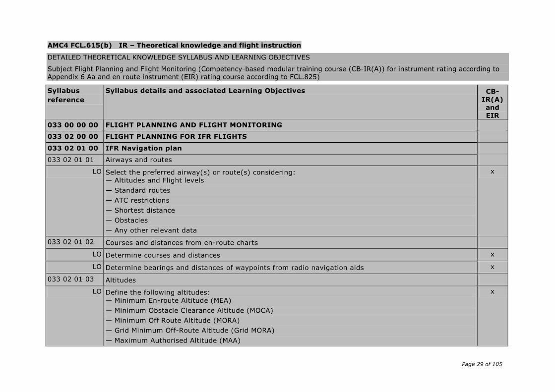
033 00 00 00 FLIGHT PLANNING AND FLIGHT MONITORING
033 02 00 00 FLIGHT PLANNING FOR IFR FLIGHTS
033 02 01 00 IFR Navigation plan
033 02 01 01 Airways and routes
LO Select the preferred airway(s) or route(s) considering:
— Altitudes and Flight levels
— Standard routes
— ATC restrictions
— Shortest distance
— Obstacles
— Any other relevant data
x
033 02 01 02 Courses and distances from en-route charts
LO Determine courses and distances x
LO Determine bearings and distances of waypoints from radio navigation aids x
033 02 01 03 Altitudes
LO Define the following altitudes:
— Minimum En-route Altitude (MEA)
— Minimum Obstacle Clearance Altitude (MOCA)
— Minimum Off Route Altitude (MORA)
— Grid Minimum Off-Route Altitude (Grid MORA)
— Maximum Authorised Altitude (MAA)
x

Page 30 of 105
Syllabus
reference
Syllabus details and associated Learning Objectives CB-
IR(A)
and
EIR
— Minimum Crossing Altitude (MCA)
— Minimum Holding Altitude (MHA)
LO Extract the following altitudes from the chart(s):
— Minimum En-route Altitude (MEA)
— Minimum Obstacle Clearance Altitude (MOCA)
— Minimum Off Route Altitude (MORA)
— Grid Minimum Off-Route Altitude (Grid MORA)
— Maximum Authorised Altitude (MAA)
— Minimum Crossing Altitude (MCA)
— Minimum Holding Altitude (MHA)
x
033 02 01 04 Standard Instrument Departures (SIDs) and Standard Arrival Routes (STARs)
LO Explain the reasons for studying SID and STAR charts x
LO State the reasons why the SID and STAR charts show procedures only in a pictorial presentation style which is not to scale
x
LO Interpret all data and information represented on SID and STAR charts, particularly:
— Routings.
— Distances
— Courses
— Radials
— Altitudes/Levels
— Frequencies
— Restrictions
x
LO Identify SIDs and STARs which might be relevant to a planned flight x
033 02 01 05 Instrument Approach Charts
LO State the reasons for being familiar with instrument approach procedures and appropriate data for departure, destination and alternate airfields
x
LO Select instrument approach procedures appropriate for departure, destination and alternate airfields x
Page 31 of 105
Syllabus
reference
Syllabus details and associated Learning Objectives CB-
IR(A)
and
EIR
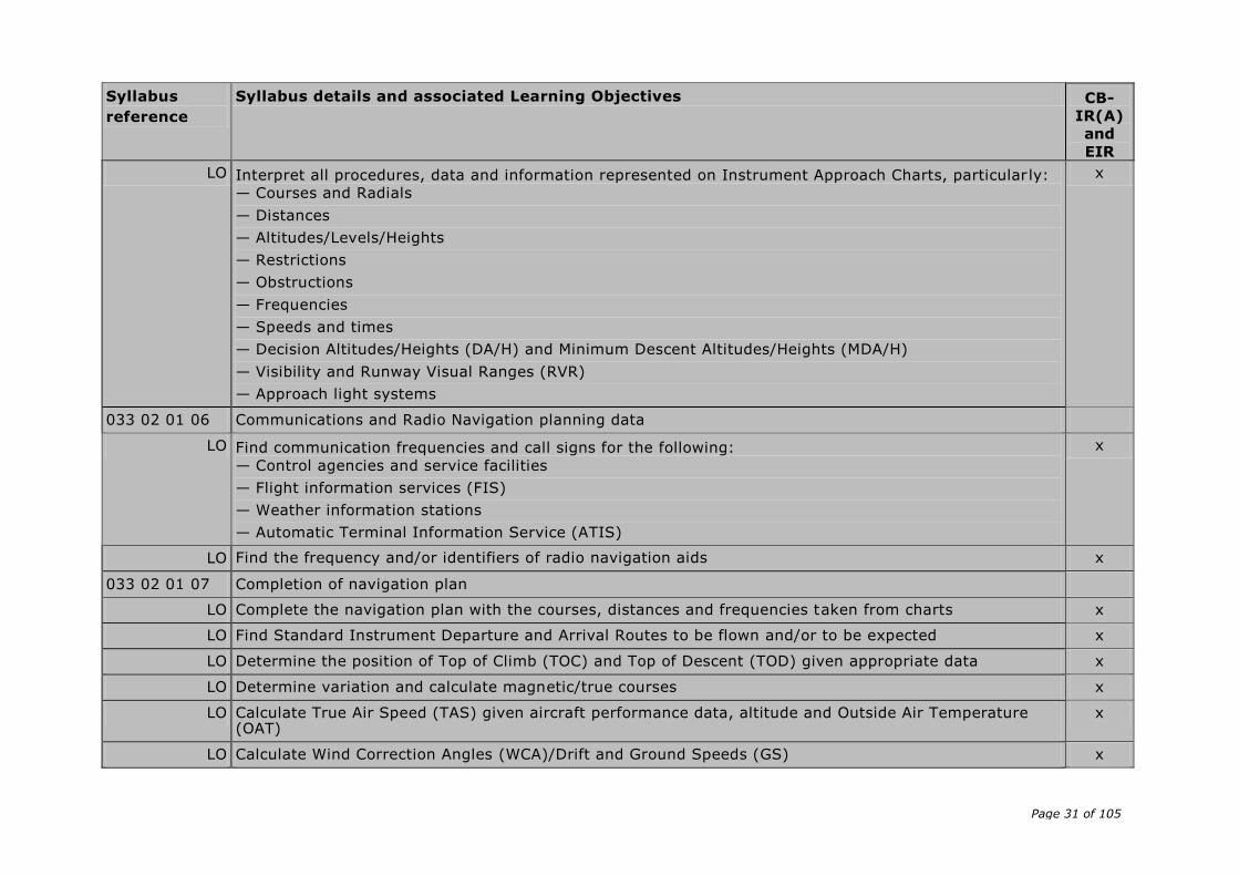
LO Interpret all procedures, data and information represented on Instrument Approach Charts, particular ly:
— Courses and Radials
— Distances
— Altitudes/Levels/Heights
— Restrictions
— Obstructions
— Frequencies
— Speeds and times
— Decision Altitudes/Heights (DA/H) and Minimum Descent Altitudes/Heights (MDA/H)
— Visibility and Runway Visual Ranges (RVR)
— Approach light systems
x
033 02 01 06 Communications and Radio Navigation planning data
LO Find communication frequencies and call signs for the following:
— Control agencies and service facilities
— Flight information services (FIS)
— Weather information stations
— Automatic Terminal Information Service (ATIS)
x
LO Find the frequency and/or identifiers of radio navigation aids x
033 02 01 07 Completion of navigation plan
LO Complete the navigation plan with the courses, distances and frequencies taken from charts x
LO Find Standard Instrument Departure and Arrival Routes to be flown and/or to be expected x
LO Determine the position of Top of Climb (TOC) and Top of Descent (TOD) given appropriate data x
LO Determine variation and calculate magnetic/true courses x
LO Calculate True Air Speed (TAS) given aircraft performance data, altitude and Outside Air Temperature (OAT)
x
LO Calculate Wind Correction Angles (WCA)/Drift and Ground Speeds (GS) x
Page 32 of 105
Syllabus
reference
Syllabus details and associated Learning Objectives CB-
IR(A)
and
EIR
LO Determine all relevant Altitudes/Levels particularly MEA, MOCA, MORA , MAA, MCA, MRA and MSA x
LO Calculate individual and accumulated times for each leg to destination and alternate airfields x
033 03 00 00 FUEL PLANNING
033 03 01 00 General
LO Convert between volume, mass and density given in different units which are commonly used in aviation x
LO Determine relevant data from flight manual, such as fuel capacity, fuel flow/consumption at different power/thrust settings, altitudes and atmospheric conditions
x
LO Calculate attainable flight time/range given fuel flow/consumption and available amount of fuel x
LO Calculate the required fuel given fuel flow/consumption and required time/range to be flown x
LO Calculate the required fuel for an IFR flight given expected meteorological conditions and expected delays under defined conditions.
x
033 04 00 00 PRE-FLIGHT PREPARATION
033 04 01 00 NOTAM briefing
033 04 01 01 Ground facilities and services
LO Check that ground facilities and services required for the planned flight are available and adequate x
033 04 01 02 Departure, destination and alternate aerodromes
LO Find and analyse the latest state at the departure, destination and alternate aerodromes, in particular
for:
— Opening hours
— Work in Progress (WIP)
— Special procedures due to Work in Progress (WIP)
— Obstructions
— Changes of frequencies for communications, navigation aids and facilities
x
033 04 01 03 Airway routings and airspace structure
LO Find and analyse the latest en-route state for:
— Airway(s) or Route(s)
x
Page 33 of 105
Syllabus
reference
Syllabus details and associated Learning Objectives CB-
IR(A)
and
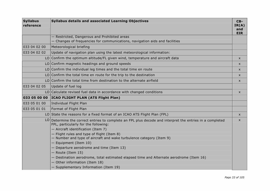
EIR — Restricted, Dangerous and Prohibited areas
— Changes of frequencies for communications, navigation aids and facilities
033 04 02 00 Meteorological briefing
033 04 02 02 Update of navigation plan using the latest meteorological information:
LO Confirm the optimum altitude/FL given wind, temperature and aircraft data x
LO Confirm magnetic headings and ground speeds x
LO Confirm the individual leg times and the total time en route x
LO Confirm the total time en route for the trip to the destination x
LO Confirm the total time from destination to the alternate airfield x
033 04 02 05 Update of fuel log
LO Calculate revised fuel data in accordance with changed conditions x
033 05 00 00 ICAO FLIGHT PLAN (ATS Flight Plan)
033 05 01 00 Individual Flight Plan
033 05 01 01 Format of Flight Plan
LO State the reasons for a fixed format of an ICAO ATS Flight Plan (FPL) x
LO Determine the correct entries to complete an FPL plus decode and interpret the entries in a completed
FPL, particularly for the following:
— Aircraft identification (Item 7)
— Flight rules and type of flight (Item 8)
— Number and type of aircraft and wake turbulence category (Item 9)
— Equipment (Item 10)
— Departure aerodrome and time (Item 13)
— Route (Item 15)
— Destination aerodrome, total estimated elapsed time and Alternate aerodrome (Item 16)
— Other information (Item 18)
— Supplementary Information (Item 19)
x
Page 34 of 105
Syllabus
reference
Syllabus details and associated Learning Objectives CB-
IR(A)
and
EIR
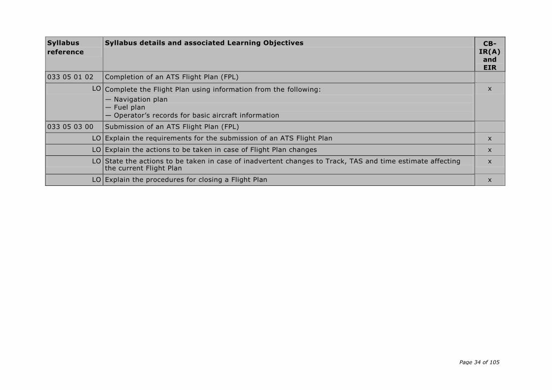
033 05 01 02 Completion of an ATS Flight Plan (FPL)
LO Complete the Flight Plan using information from the following:
— Navigation plan
— Fuel plan
— Operator’s records for basic aircraft information
x
033 05 03 00 Submission of an ATS Flight Plan (FPL)
LO Explain the requirements for the submission of an ATS Flight Plan x
LO Explain the actions to be taken in case of Flight Plan changes x
LO State the actions to be taken in case of inadvertent changes to Track, TAS and time estimate affecting the current Flight Plan
x
LO Explain the procedures for closing a Flight Plan x
Page 35 of 105
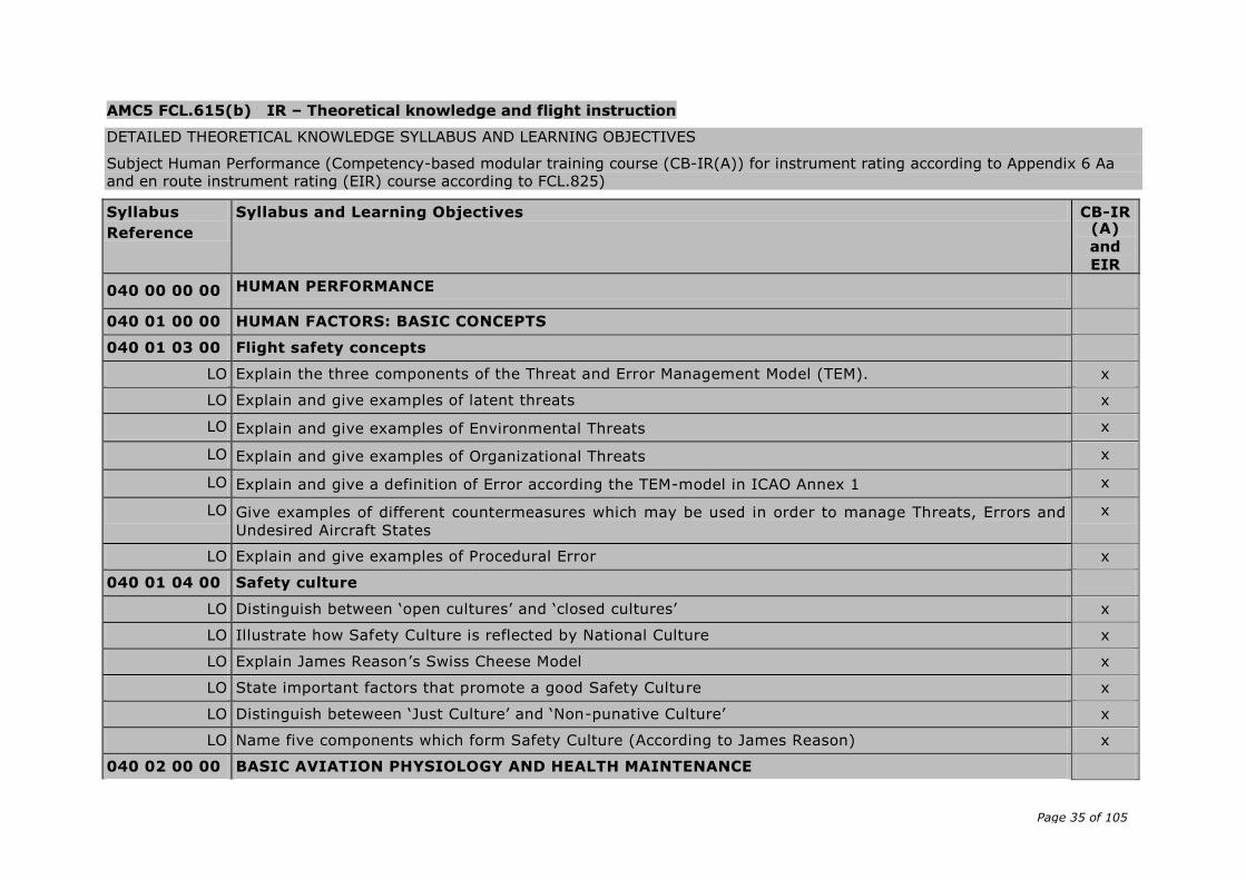
AMC5 FCL.615(b) IR – Theoretical knowledge and flight instruction
DETAILED THEORETICAL KNOWLEDGE SYLLABUS AND LEARNING OBJECTIVES
Subject Human Performance (Competency-based modular training course (CB-IR(A)) for instrument rating according to Appendix 6 Aa and en route instrument rating (EIR) course according to FCL.825)
Syllabus
Reference
Syllabus and Learning Objectives CB-IR (A)
and
EIR
040 00 00 00 HUMAN PERFORMANCE
040 01 00 00 HUMAN FACTORS: BASIC CONCEPTS
040 01 03 00 Flight safety concepts
LO Explain the three components of the Threat and Error Management Model (TEM). x
LO Explain and give examples of latent threats x
LO Explain and give examples of Environmental Threats x
LO Explain and give examples of Organizational Threats x
LO Explain and give a definition of Error according the TEM-model in ICAO Annex 1 x
LO Give examples of different countermeasures which may be used in order to manage Threats, Errors and
Undesired Aircraft States
x
LO Explain and give examples of Procedural Error x
040 01 04 00 Safety culture
LO Distinguish between ‘open cultures’ and ‘closed cultures’ x
LO Illustrate how Safety Culture is reflected by National Culture x
LO Explain James Reason’s Swiss Cheese Model x
LO State important factors that promote a good Safety Culture x
LO Distinguish beteween ‘Just Culture’ and ‘Non-punative Culture’ x
LO Name five components which form Safety Culture (According to James Reason) x
040 02 00 00 BASIC AVIATION PHYSIOLOGY AND HEALTH MAINTENANCE

Page 36 of 105
Syllabus
Reference
Syllabus and Learning Objectives CB-IR (A)
and
EIR
040 02 01 00 Basics of flight physiology
040 02 01 02 Respiratory and circulatory systems
LO Define 'linear', 'angular' and 'radial acceleration' x
LO Describe the effects of acceleration on the circulation and blood volume distribution x
LO List the factors determining the effects of acceleration on the human body x
LO Describe measures which may be taken to increase tolerance to positive acceleration x
LO List the effects of positive acceleration with respect to type, sequence and the corresponding G-load x
040 02 02 00 Man and Environment: the sensory system
LO List the different senses x
LO State the multi-sensory nature of human perception x
040 02 02 04 Equilibrium
Functional Anatomy
LO List the main elements of the vestibular apparatus x
LO State the functions of the vestibular apparatus on the ground and in flight x
LO Distinguish between the component parts of the vestibular apparatus in the detection of linear and angular acceleration as well as on gravity
x
LO Explain how the semicircular canals are stimulated x
Motion sickness
LO Describe air-sickness and its accompanying symptoms x
LO List the causes of motion sickness x
LO Describe the necessary actions to be taken to counteract the symptoms of motion sickness x
040 02 02 05 Integration of sensory inputs
LO State the interaction between vision, equilibrium, proprioception and hearing to obtain spatial orientation in flight
x
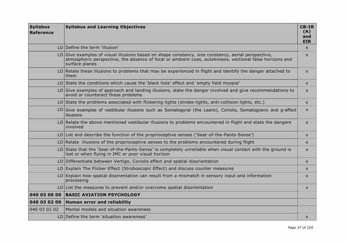
Page 37 of 105
Syllabus
Reference
Syllabus and Learning Objectives CB-IR (A)
and
EIR
LO Define the term ‘illusion’ x
LO Give examples of visual illusions based on shape constancy, size constancy, aerial perspective, atmospheric perspective, the absence of focal or ambient cues, autokinesis, vectional false horizons and surface planes
x
LO Relate these illusions to problems that may be experienced in flight and identify the danger attached to them
x
LO State the conditions which cause the ‘black hole’ effect and ‘empty field myopia’ x
LO Give examples of approach and landing illusions, state the danger involved and give recommendations to avoid or counteract these problems
x
LO State the problems associated with flickering lights (strobe-lights, anti-collision lights, etc.) x
LO Give examples of vestibular illusions such as Somatogyral (the Leans), Coriolis, Somatogravic and g-effect
illusions
x
LO Relate the above mentioned vestibular illusions to problems encountered in flight and state the dangers involved
x
LO List and describe the function of the proprioceptive senses (‘Seat-of-the-Pants-Sense’) x
LO Relate illusions of the proprioceptive senses to the problems encountered during flight x
LO State that the ‘Seat-of-the-Pants-Sense’ is completely unreliable when visual contact with the ground is lost or when flying in IMC or poor visual horizon
x
LO Differentiate between Vertigo, Coriolis effect and spatial disorientation x
LO Explain The Flicker Effect (Stroboscopic Effect) and discuss counter measures x
LO Explain how spatial disorientation can result from a mismatch in sensory input and information processing
x
LO List the measures to prevent and/or overcome spatial disorientation x
040 03 00 00 BASIC AVIATION PSYCHOLOGY
040 03 02 00 Human error and reliability
040 03 02 02 Mental models and situation awareness
LO Define the term 'situation awareness' x
Page 38 of 105
Syllabus
Reference
Syllabus and Learning Objectives CB-IR (A)
and
EIR
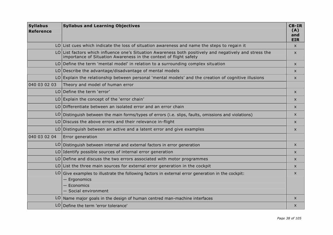
LO List cues which indicate the loss of situation awareness and name the steps to regain it x
LO List factors which influence one’s Situation Awareness both positively and negatively and stress the importance of Situation Awareness in the context of flight safety
x
LO Define the term 'mental model' in relation to a surrounding complex situation x
LO Describe the advantage/disadvantage of mental models x
LO Explain the relationship between personal ‘mental models’ and the creation of cognitive illusions x
040 03 02 03 Theory and model of human error
LO Define the term ‘error’ x
LO Explain the concept of the ‘error chain’ x
LO Differentiate between an isolated error and an error chain x
LO Distinguish between the main forms/types of errors (i.e. slips, faults, omissions and violations) x
LO Discuss the above errors and their relevance in-flight x
LO Distinguish between an active and a latent error and give examples x
040 03 02 04 Error generation
LO Distinguish between internal and external factors in error generation x
LO Identify possible sources of internal error generation x
LO Define and discuss the two errors associated with motor programmes x
LO List the three main sources for external error generation in the cockpit x
LO Give examples to illustrate the following factors in external error generation in the cockpit:
— Ergonomics
— Economics
— Social environment
x
LO Name major goals in the design of human centred man-machine interfaces x
LO Define the term 'error tolerance' x
Page 39 of 105
Syllabus
Reference
Syllabus and Learning Objectives CB-IR (A)
and
EIR
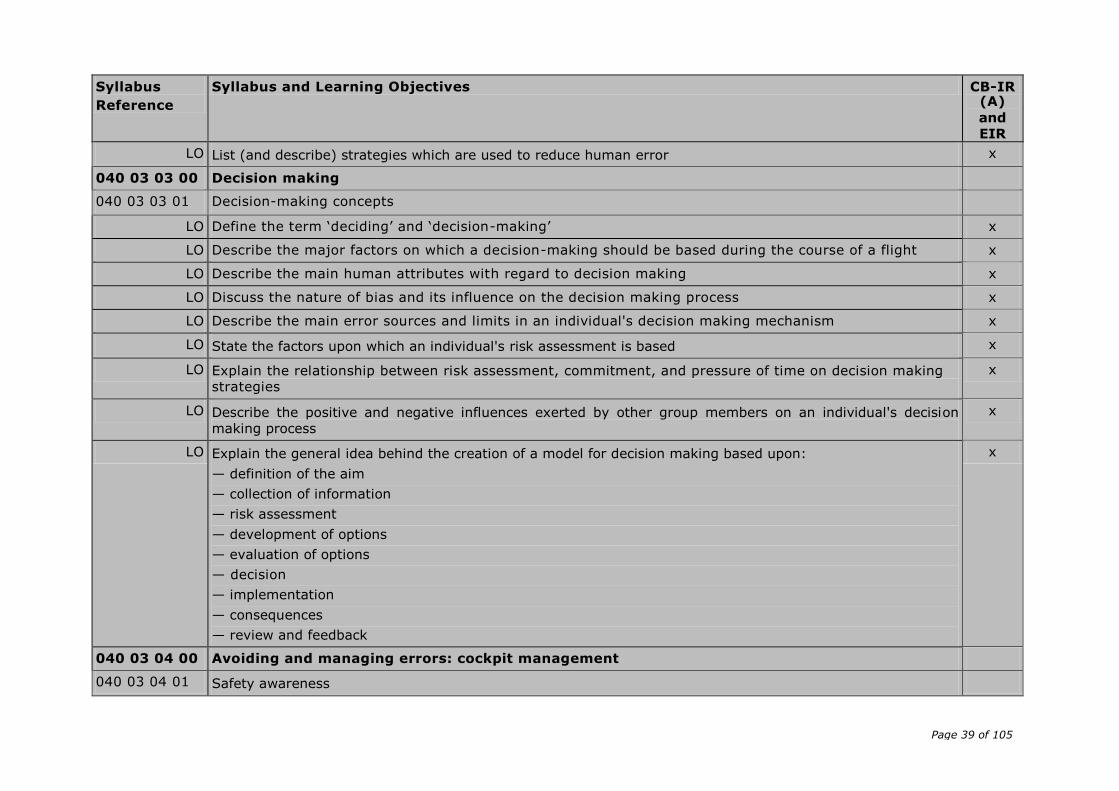
LO List (and describe) strategies which are used to reduce human error x
040 03 03 00 Decision making
040 03 03 01 Decision-making concepts
LO Define the term ‘deciding’ and ‘decision-making’ x
LO Describe the major factors on which a decision-making should be based during the course of a flight x
LO Describe the main human attributes with regard to decision making x
LO Discuss the nature of bias and its influence on the decision making process x
LO Describe the main error sources and limits in an individual's decision making mechanism x
LO State the factors upon which an individual's risk assessment is based x
LO Explain the relationship between risk assessment, commitment, and pressure of time on decision making strategies
x
LO Describe the positive and negative influences exerted by other group members on an individual's decision
making process
x
LO Explain the general idea behind the creation of a model for decision making based upon:
— definition of the aim
— collection of information
— risk assessment
— development of options
— evaluation of options
— decision
— implementation
— consequences
— review and feedback
x
040 03 04 00 Avoiding and managing errors: cockpit management
040 03 04 01 Safety awareness
Page 40 of 105
Syllabus
Reference
Syllabus and Learning Objectives CB-IR (A)
and
EIR
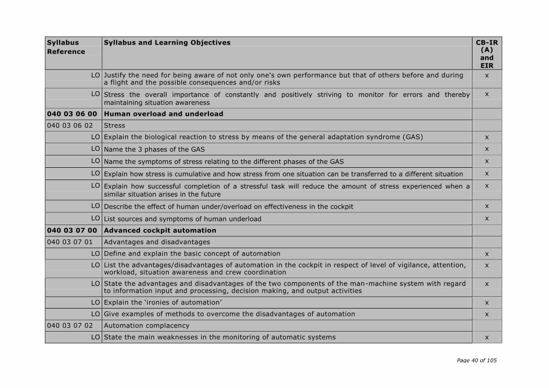
LO Justify the need for being aware of not only one's own performance but that of others before and during a flight and the possible consequences and/or risks
x
LO Stress the overall importance of constantly and positively striving to monitor for errors and thereby
maintaining situation awareness
x
040 03 06 00 Human overload and underload
040 03 06 02 Stress
LO Explain the biological reaction to stress by means of the general adaptation syndrome (GAS) x
LO Name the 3 phases of the GAS x
LO Name the symptoms of stress relating to the different phases of the GAS x
LO Explain how stress is cumulative and how stress from one situation can be transferred to a different situation x
LO Explain how successful completion of a stressful task will reduce the amount of stress experienced when a
similar situation arises in the future
x
LO Describe the effect of human under/overload on effectiveness in the cockpit x
LO List sources and symptoms of human underload x
040 03 07 00 Advanced cockpit automation
040 03 07 01 Advantages and disadvantages
LO Define and explain the basic concept of automation x
LO List the advantages/disadvantages of automation in the cockpit in respect of level of vigilance, attention, workload, situation awareness and crew coordination
x
LO State the advantages and disadvantages of the two components of the man-machine system with regard to information input and processing, decision making, and output activities
x
LO Explain the ‘ironies of automation’ x
LO Give examples of methods to overcome the disadvantages of automation x
040 03 07 02 Automation complacency
LO State the main weaknesses in the monitoring of automatic systems x
Page 41 of 105
Syllabus
Reference
Syllabus and Learning Objectives CB-IR (A)
and
EIR
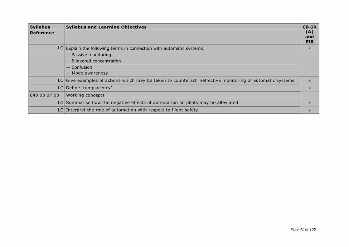
LO Explain the following terms in connection with automatic systems:
— Passive monitoring
— Blinkered concentration
— Confusion
— Mode awareness
x
LO Give examples of actions which may be taken to counteract ineffective monitoring of automatic systems x
LO Define ‘complacency’ x
040 03 07 03 Working concepts
LO Summarise how the negative effects of automation on pilots may be alleviated x
LO Interpret the role of automation with respect to flight safety x

Page 42 of 105
AMC6 FCL.615(b) IR – Theoretical knowledge and flight instruction
DETAILED THEORETICAL KNOWLEDGE SYLLABUS AND LEARNING OBJECTIVES
Subject Meteorology (Competency-based modular training course (CB-IR(A)) for instrument rating according to Appendix 6 Aa and
en route instrument rating (EIR) course according to FCL.825)
Syllabus reference
Syllabus details and associated Learning Objectives CB-IR (A)
and
EIR
050 00 00 00 METEOROLOGY
050 01 00 00 THE ATMOSPHERE
050 01 02 00 Air temperature
050 01 02 04 Lapse rates
LO Describe qualitatively and quantitatively the temperature lapse rates of the troposphere (mean value 0.65°C/100 m or 2°C/1 000 ft and actual values)
x
050 01 02 05 Development of inversions, types of inversions
LO Describe development and types of inversions x
LO Explain the characteristics of inversions and of an isothermal layer x
LO Explain the reasons for the formation of the following inversions:
— ground inversion (nocturnal radiation/advection), subsidence inversion, frontal inversion, inversion above friction layer, valley inversion
x
— tropopause inversion
050 01 02 06 Temperature near the earth’s surface, surface effects, diurnal and seasonal variation, effect of clouds, effect of wind
LO Describe how the temperature near the earth’s surface is influenced by seasonal variations x
LO Explain the cooling and warming of the air on the earth or sea surfaces x
LO Sketch the diurnal variation of the temperature of the air in relation to the radiation of the sun and of the earth
x
LO Describe qualitatively the influence of the clouds on the cooling and warming of the surface and the air near the surface
x
Page 43 of 105
Syllabus reference
Syllabus details and associated Learning Objectives CB-IR (A)
and
EIR
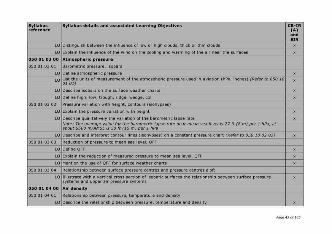
LO Distinguish between the influence of low or high clouds, thick or thin clouds x
LO Explain the influence of the wind on the cooling and warming of the air near the surfaces x
050 01 03 00 Atmospheric pressure
050 01 03 01 Barometric pressure, isobars
LO Define atmospheric pressure x
LO List the units of measurement of the atmospheric pressure used in aviation (hPa, inches) (Refer to 050 10 01 01)
x
LO Describe isobars on the surface weather charts x
LO Define high, low, trough, ridge, wedge, col x
050 01 03 02 Pressure variation with height, contours (isohypses)
LO Explain the pressure variation with height x
LO Describe qualitatively the variation of the barometric lapse rate
Note: The average value for the barometric lapse rate near mean sea level is 27 ft (8 m) per 1 hPa, at about 5500 m/AMSL is 50 ft (15 m) per 1 hPa
x
LO Describe and interpret contour lines (isohypses) on a constant pressure chart (Refer to 050 10 02 03) x
050 01 03 03 Reduction of pressure to mean sea level, QFF
LO Define QFF x
LO Explain the reduction of measured pressure to mean sea level, QFF x
LO Mention the use of QFF for surface weather charts x
050 01 03 04 Relationship between surface pressure centres and pressure centres aloft
LO Illustrate with a vertical cross section of isobaric surfaces the relationship between surface pressure systems and upper air pressure systems
x
050 01 04 00 Air density
050 01 04 01 Relationship between pressure, temperature and density
LO Describe the relationship between pressure, temperature and density x

Page 44 of 105
Syllabus reference
Syllabus details and associated Learning Objectives CB-IR (A)
and
EIR
LO Describe the vertical variation of the air density in the atmosphere x
LO Describe the effect of humidity changes on the density of air x
050 01 05 00 ICAO Standard Atmosphere (ISA)
050 01 05 01 ICAO Standard Atmosphere
LO Explain the use of standardised values for the atmosphere x
LO List the main values of the ISA (mean sea level pressure, mean sea level temperature, the vertical temperature lapse rate up to 20 km, height and temperature of the tropopause)
x
LO Calculate the standard temperature in degree Celsius for a given flight level x
LO Determine a standard temperature deviation by the difference between the given outside air temperature and the standard temperature
x
050 01 06 00 Altimetry
050 01 06 01 Terminology and definitions
LO Define the following terms and abbreviations and explain how they are related to each other: height, altitude, pressure altitude, flight level, level, true altitude, true height, elevation, QNH, QFE and standard altimeter setting
x
LO Describe the terms transition altitude, transition level, transition layer, terrain clearance, lowest usable flight level
x
050 01 06 03 Calculations
LO Calculate the different readings on the altimeter when the pilot changes the altimeter setting x
LO Illustrate with a numbered example the changes of altimeter setting and the associated changes in reading when the pilot climbs through the transition altitude or descends through the transition level
x
LO Derive the reading of the altimeter of an aircraft on the ground when the pilot uses the different settings x
LO Explain the influence of the air temperature on the distance between the ground and the level read on the altimeter and between two flight levels
x
LO Explain the influence of pressure areas on the true altitude x
LO Determine the true altitude/height for a given altitude/height and a given ISA temperature deviation x
Page 45 of 105
Syllabus reference
Syllabus details and associated Learning Objectives CB-IR (A)
and
EIR
LO Calculate the terrain clearance and the lowest usable flight level for given atmospheric temperature and pressure conditions
x
Note: The following rules shall be considered for altimetry calculations:
a. All calculations are based on rounded pressure values to the nearest lower hPa
b. The value for the barometric lapse rate near mean sea level is 27 ft (8 m) per 1 hPa
c. To determine the true altitude/height the following rule of thumb, called the ‘4 %-rule’, shall be used: the altitude/height changes by 4 % for each 10°C temperature deviation from ISA
d. If no further information is given, the deviation of outside air temperature from ISA is considered to be constantly the same given value in the whole layer
e. The elevation of the airport has to be taken into account. The temperature correction has to be considered for the layer between ground and the position of the aircraft
050 01 06 04 Effect of accelerated airflow due to topography
LO Describe qualitatively how the effect of accelerated airflow due to topography (Bernoulli effect) affects altimetry
x
050 02 00 00 WIND
050 02 02 00 Primary cause of wind
050 02 02 02 Variation of wind in the friction layer
LO Describe why and how the wind changes direction and speed with height in the friction layer in the northern and in the southern hemisphere (rule of thumb)
x
LO Explain the relationship between isobars and wind (direction and speed) x
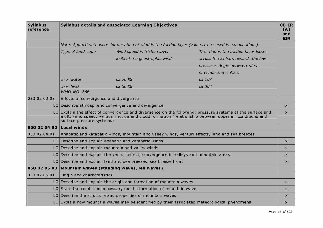
Page 46 of 105
Syllabus reference
Syllabus details and associated Learning Objectives CB-IR (A)
and
EIR
Note: Approximate value for variation of wind in the friction layer (values to be used in examinations):
Type of landscape Wind speed in friction layer The wind in the friction layer blows
in % of the geostrophic wind across the isobars towards the low
pressure. Angle between wind
direction and isobars
over water ca 70 % ca 10°
over land ca 50 % ca 30°
WMO-NO. 266
050 02 02 03 Effects of convergence and divergence
LO Describe atmospheric convergence and divergence x
LO Explain the effect of convergence and divergence on the following: pressure systems at the surface and aloft; wind speed; vertical motion and cloud formation (relationship between upper air conditions and surface pressure systems)
x
050 02 04 00 Local winds
050 02 04 01 Anabatic and katabatic winds, mountain and valley winds, venturi effects, land and sea breezes
LO Describe and explain anabatic and katabatic winds x
LO Describe and explain mountain and valley winds x
LO Describe and explain the venturi effect, convergence in valleys and mountain areas x
LO Describe and explain land and sea breezes, sea breeze front x
050 02 05 00 Mountain waves (standing waves, lee waves)
050 02 05 01 Origin and characteristics
LO Describe and explain the origin and formation of mountain waves x
LO State the conditions necessary for the formation of mountain waves x
LO Describe the structure and properties of mountain waves x
LO Explain how mountain waves may be identified by their associated meteorological phenomena x
Page 47 of 105
Syllabus reference
Syllabus details and associated Learning Objectives CB-IR (A)
and
EIR
050 02 06 00 Turbulence
050 02 06 01 Description and types of turbulence
LO Describe turbulence and gustiness x
LO List common types of turbulence (convective, mechanical, orographic, frontal, clear air turbulence) x
050 02 06 02 Formation and location of turbulence
LO Explain the formation of convective turbulence, mechanical and orographic turbulence, frontal turbulence, clear air turbulence (Refer to 050 02 06 03)
x
LO State where turbulence will normally be found (rough ground surfaces, relief, inversion layers, CB, TS zones, unstable layers)
x
050 03 00 00 THERMODYNAMICS
050 03 01 00 Humidity
050 03 01 01 Water vapour in the atmosphere
LO Describe humid air x
LO Describe the significance of water vapour in the atmosphere for meteorology x
LO Indicate the sources of atmospheric humidity x
050 03 01 03 Temperature/dew point, relative humidity
LO Define dew point x
LO Recognise the dew point curve on a simplified diagram (T,P) x
LO Define relative humidity x
LO Explain the factors influencing the relative humidity at constant pressure x
LO Explain the diurnal variation of the relative humidity x
LO Describe the relationship between relative humidity, the amount of water vapour and the temperature x
LO Describe the relationship between temperature and dew point x
LO Estimate the relative humidity of the air from the difference between dew point and temperature x
050 04 00 00 CLOUDS AND FOG
Page 48 of 105
Syllabus reference
Syllabus details and associated Learning Objectives CB-IR (A)
and
EIR
050 04 01 00 Cloud formation and description
050 04 01 01 Cloud formation
LO Explain cloud formation by adiabatic cooling, conduction, advection and radiation x
LO Describe the cloud formation based on the following lifting processes: unorganised lifting in thin layers and turbulent mixing; forced lifting at fronts or over mountains; free convection
x
LO Determine the cloud base and top in a simplified diagram (temperature, pressure, humidity) x
LO Explain the influence of relative humidity on the height of the cloud base x
LO Illustrate in a thermodynamic diagram the meaning of convective temperature (temperature at which formation of cumulus starts)
x
LO List cloud types typical for stable and unstable air conditions x
LO Summarise the conditions for the dissipation of clouds x
050 04 01 02 Cloud types and cloud classification
LO Describe cloud types and cloud classification x
LO Identify by shape cirriform, cumuliform and stratiform clouds x
LO Identify by shape and typical level the ten cloud types (genera) x
LO Describe and identify by shape the following species and supplementary feature: castellanus, lenticularis, fractus, humilis, mediocris, congestus, calvus, capillatus and virga
x
LO Distinguish between low, medium and high level clouds according to the WMO cloud étage (including heights)
— for mid-latitudes x
— for all latitudes
LO Distinguish between ice clouds, mixed clouds and pure water clouds x
050 04 01 03 Influence of inversions on cloud development
LO Explain the influence of inversions on vertical movements in the atmosphere x
LO Explain the influence of an inversion on the formation of stratus clouds x

Page 49 of 105
Syllabus reference
Syllabus details and associated Learning Objectives CB-IR (A)
and
EIR
LO Explain the influence of ground inversion on the formation of fog x
LO Determine the top of a cumulus cloud caused by an inversion on a simplified diagram x
050 04 01 04 Flying conditions in each cloud type
LO Assess the ten cloud types for icing and turbulence x
050 04 02 00 Fog, mist, haze
050 04 02 01 General aspects
LO Define fog, mist and haze with reference to WMO standards of visibility range x
LO Explain the formation of fog, mist and haze in general x
LO Name the factors contributing in general to the formation of fog and mist x
LO Name the factors contributing to the formation of haze x
LO Describe freezing fog and ice fog x
050 04 02 02 Radiation fog
LO Explain the formation of radiation fog x
LO Explain the conditions for the development of radiation fog x
LO Describe the significant characteristics of radiation fog, and its vertical extent x
LO Summarise the conditions for the dissipation of radiation fog x
050 04 02 03 Advection fog
LO Explain the formation of advection fog x
LO Explain the conditions for the development of advection fog x
LO Describe the different possibilities of advection fog formation (over land, sea and coastal regions) x
LO Describe significant characteristics of advection fog x
LO Summarise the conditions for the dissipation of advection fog x
050 04 02 04 Steam fog
LO Explain the formation of steam fog x
Page 50 of 105
Syllabus reference
Syllabus details and associated Learning Objectives CB-IR (A)
and
EIR
LO Explain the conditions for the development of steam fog x
LO Describe significant characteristics of steam fog x
LO Summarise the conditions for the dissipation of steam fog x
050 04 02 05 Frontal fog
LO Explain the formation of frontal fog x
LO Explain the conditions for the development of frontal fog x
LO Describe significant characteristics of frontal fog x
LO Summarise the conditions for the dissipation of frontal fog x
050 04 02 06 Orographic fog (hill fog)
LO Summarise the features of orographic fog x
LO Explain the conditions for the development of orographic fog x
LO Describe significant characteristics of orographic fog x
LO Summarise the conditions for the dissipation of orographic fog x
050 05 00 00 PRECIPITATION
050 05 01 00 Development of precipitation
050 05 01 01 Process of development of precipitation
LO Distinguish between the two following processes by which precipitation is formed x
LO — Summarise the outlines of the ice crystal process (Bergeron-Findeisen) x
LO — Summarise the outlines of the coalescence process x
LO Describe the atmospheric conditions that favour either process x
LO Explain the development of snow, rain, drizzle and hail x
050 05 02 00 Types of precipitation
050 05 02 01 Types of precipitation, relationship with cloud types
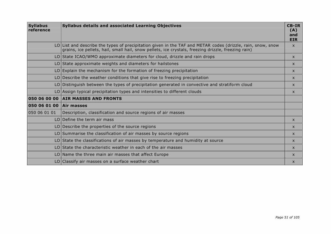
Page 51 of 105
Syllabus reference
Syllabus details and associated Learning Objectives CB-IR (A)
and
EIR
LO List and describe the types of precipitation given in the TAF and METAR codes (drizzle, rain, snow, snow grains, ice pellets, hail, small hail, snow pellets, ice crystals, freezing drizzle, freezing rain)
x
LO State ICAO/WMO approximate diameters for cloud, drizzle and rain drops x
LO State approximate weights and diameters for hailstones x
LO Explain the mechanism for the formation of freezing precipitation x
LO Describe the weather conditions that give rise to freezing precipitation x
LO Distinguish between the types of precipitation generated in convective and stratiform cloud x
LO Assign typical precipitation types and intensities to different clouds x
050 06 00 00 AIR MASSES AND FRONTS
050 06 01 00 Air masses
050 06 01 01 Description, classification and source regions of air masses
LO Define the term air mass x
LO Describe the properties of the source regions x
LO Summarise the classification of air masses by source regions x
LO State the classifications of air masses by temperature and humidity at source x
LO State the characteristic weather in each of the air masses x
LO Name the three main air masses that affect Europe x
LO Classify air masses on a surface weather chart x
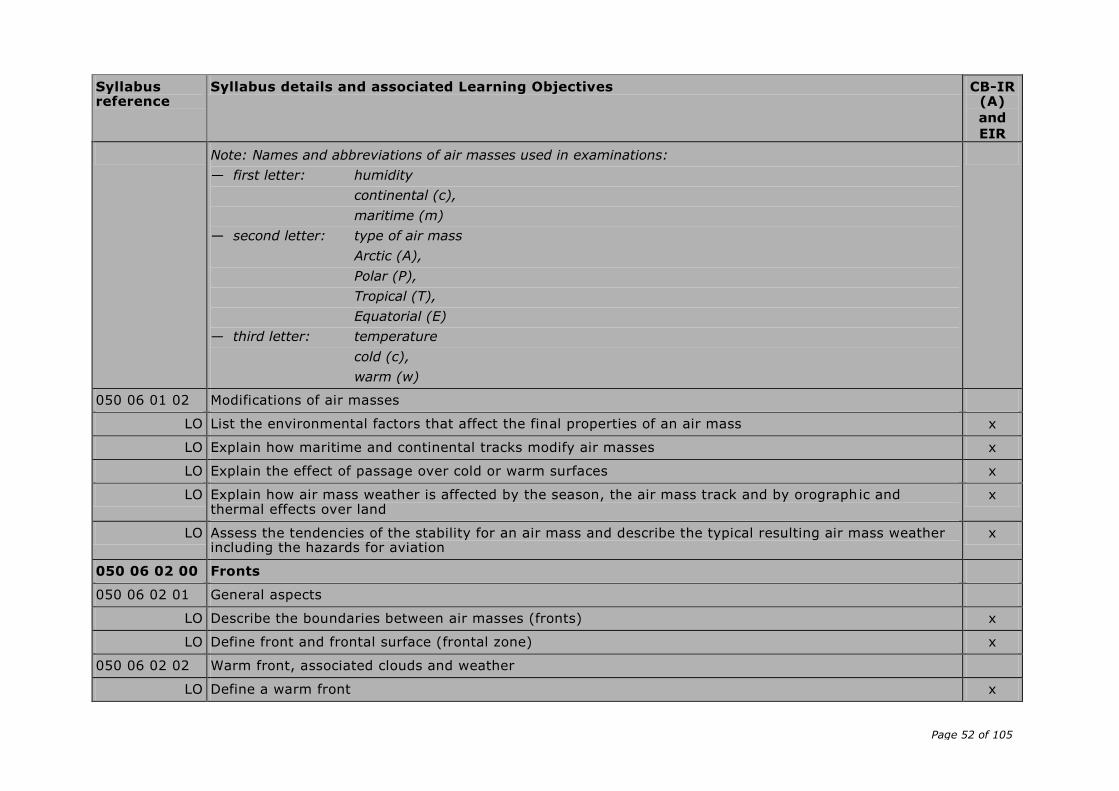
Page 52 of 105
Syllabus reference
Syllabus details and associated Learning Objectives CB-IR (A)
and
EIR
Note: Names and abbreviations of air masses used in examinations:
— first letter: humidity
continental (c),
maritime (m)
— second letter: type of air mass
Arctic (A),
Polar (P),
Tropical (T),
Equatorial (E)
— third letter: temperature
cold (c),
warm (w)
050 06 01 02 Modifications of air masses
LO List the environmental factors that affect the final properties of an air mass x
LO Explain how maritime and continental tracks modify air masses x
LO Explain the effect of passage over cold or warm surfaces x
LO Explain how air mass weather is affected by the season, the air mass track and by orographic and thermal effects over land
x
LO Assess the tendencies of the stability for an air mass and describe the typical resulting air mass weather including the hazards for aviation
x
050 06 02 00 Fronts
050 06 02 01 General aspects
LO Describe the boundaries between air masses (fronts) x
LO Define front and frontal surface (frontal zone) x
050 06 02 02 Warm front, associated clouds and weather
LO Define a warm front x

Page 53 of 105
Syllabus reference
Syllabus details and associated Learning Objectives CB-IR (A)
and
EIR
LO Describe the cloud, weather, ground visibility and aviation hazards at a warm front depending on the stability of the warm air
x
LO Explain the seasonal differences in the weather at warm fronts x
LO Describe the structure, slope and dimensions of a warm front x
LO Sketch a cross-section of a warm front, showing weather, cloud and aviation hazards x
050 06 02 03 Cold front, associated clouds and weather
LO Define a cold front x
LO Describe the cloud, weather, ground visibility and aviation hazards at a cold front depending on the stability of the warm air
x
LO Explain the seasonal differences in the weather at cold fronts x
LO Describe the structure, slope and dimensions of a cold front x
LO Sketch a cross-section of a cold front, showing weather, cloud and aviation hazards x
050 06 02 04 Warm sector, associated clouds and weather
LO Define fronts and air masses associated with the warm sector x
LO Describe the cloud, weather, ground visibility and aviation hazards in a warm sector x
LO Explain the seasonal differences in the weather in the warm sector x
LO Sketch a cross-section of a warm sector, showing weather, cloud and aviation hazards x
050 06 02 05 Weather behind the cold front
LO Describe the cloud, weather, ground visibility and aviation hazards behind the cold front x
LO Explain the seasonal differences in the weather behind the cold front x
050 06 02 06 Occlusions, associated clouds and weather
LO Define the term occlusion x
LO Define a cold occlusion x
LO Define a warm occlusion x
LO Describe the cloud, weather, ground visibility and aviation hazards in a cold occlusion x

Page 54 of 105
Syllabus reference
Syllabus details and associated Learning Objectives CB-IR (A)
and
EIR
LO Describe the cloud, weather, ground visibility and aviation hazards in a warm occlusion x
LO Explain the seasonal differences in the weather at occlusions x
LO Sketch a cross-section of cold and warm occlusions, showing weather, cloud and aviation hazards x
LO In a sketch plan illustrate the development of an occlusion and the movement of the occlusion point x
050 06 02 07 Stationary front, associated clouds and weather
LO Define a stationary or quasi-stationary front x
LO Describe the cloud, weather, ground visibility and aviation hazards in a stationary or quasi-stationary front
x
050 06 02 08 Movement of fronts and pressure systems, life cycle
LO Describe the movements of fronts and pressure systems and the life cycle of a mid-latitude depression x
LO State the rules for predicting the direction and the speed of movement of fronts x
LO Explain the difference between the speed of movement of cold and warm fronts x
LO State the rules for predicting the direction and the speed of movement of frontal depressions x
LO Describe, with a sketch if required, the genesis, development and life cycle of a frontal depression with associated cloud and rain belts
x
050 06 02 09 Changes of meteorological elements at a frontal wave
LO Sketch a plan and a cross-section of a frontal wave (warm front, warm sector and cold front) and illustrate the changes of pressure, temperature, surface wind and wind in the vertical axis
x
050 07 00 00 PRESSURE SYSTEMS
050 07 02 00 Anticyclone
050 07 02 01 Anticyclones, types, general properties, cold and warm anticyclones, ridges and wedges, subsidence
LO List the different types of anticyclones x
LO Describe the effect of high level convergence in producing areas of high pressure at ground level x
LO Describe air mass subsidence, its effect on the environmental lapse rate, and the associated weather x
LO Describe the formation of warm and cold anticyclones x
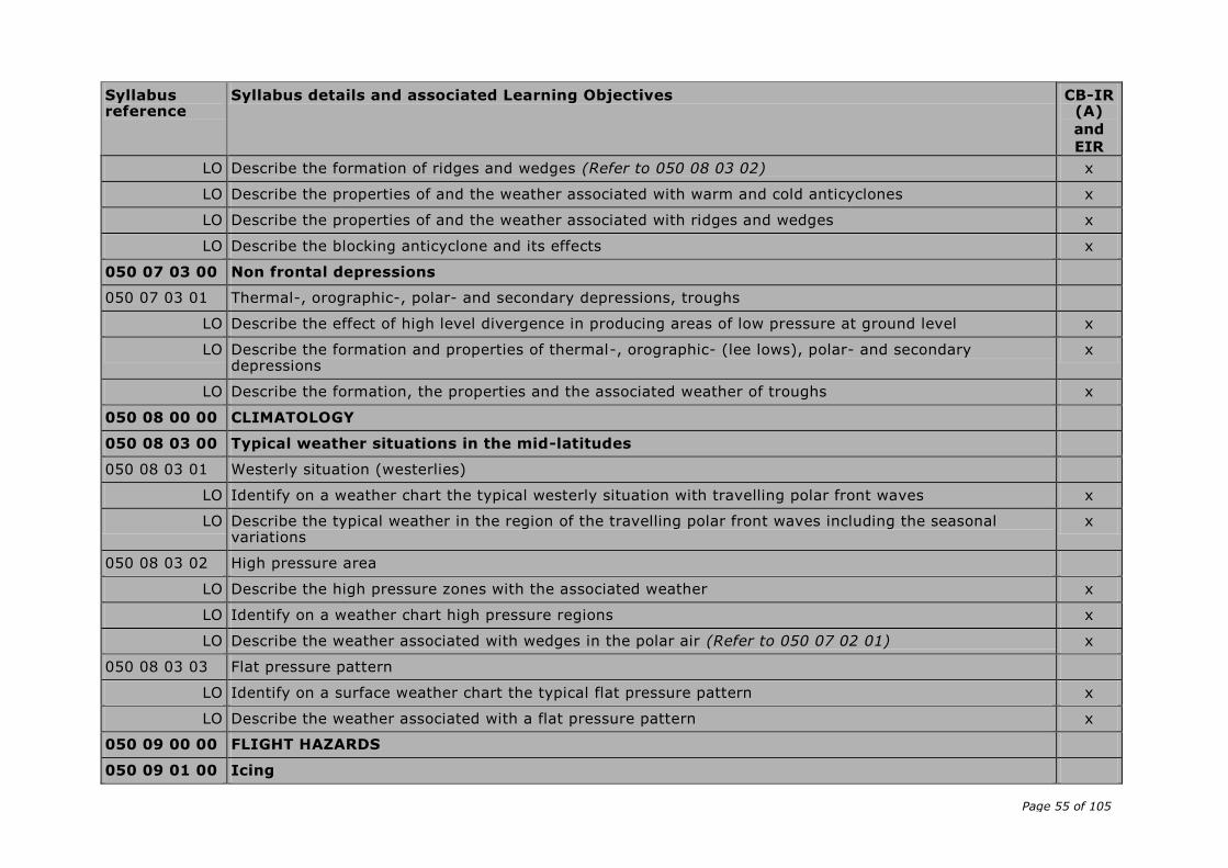
Page 55 of 105
Syllabus reference
Syllabus details and associated Learning Objectives CB-IR (A)
and
EIR
LO Describe the formation of ridges and wedges (Refer to 050 08 03 02) x
LO Describe the properties of and the weather associated with warm and cold anticyclones x
LO Describe the properties of and the weather associated with ridges and wedges x
LO Describe the blocking anticyclone and its effects x
050 07 03 00 Non frontal depressions
050 07 03 01 Thermal-, orographic-, polar- and secondary depressions, troughs
LO Describe the effect of high level divergence in producing areas of low pressure at ground level x
LO Describe the formation and properties of thermal-, orographic- (lee lows), polar- and secondary depressions
x
LO Describe the formation, the properties and the associated weather of troughs x
050 08 00 00 CLIMATOLOGY
050 08 03 00 Typical weather situations in the mid-latitudes
050 08 03 01 Westerly situation (westerlies)
LO Identify on a weather chart the typical westerly situation with travelling polar front waves x
LO Describe the typical weather in the region of the travelling polar front waves including the seasonal variations
x
050 08 03 02 High pressure area
LO Describe the high pressure zones with the associated weather x
LO Identify on a weather chart high pressure regions x
LO Describe the weather associated with wedges in the polar air (Refer to 050 07 02 01) x
050 08 03 03 Flat pressure pattern
LO Identify on a surface weather chart the typical flat pressure pattern x
LO Describe the weather associated with a flat pressure pattern x
050 09 00 00 FLIGHT HAZARDS
050 09 01 00 Icing

Page 56 of 105
Syllabus reference
Syllabus details and associated Learning Objectives CB-IR (A)
and
EIR
050 09 01 01 Conditions for ice accretion
LO Summarise the general conditions under which ice accretion occurs on aircraft (temperatures of outside air; temperature of the airframe; presence of supercooled water in clouds, fog, rain and drizzle; possibility of sublimation)
x
LO Indicate the general weather conditions under which ice accretion in venturi carburettor occurs x
LO Explain the general weather conditions under which ice accretion on airframe occurs x
LO Explain the formation of supercooled water in clouds, rain and drizzle (Refer to 050 03 02 01) x
LO Explain qualitatively the relationship between the air temperature and the amount of supercooled water x
LO Explain qualitatively the relationship between the type of cloud and the size and number of the droplets, in cumuliform and stratiform clouds
x
LO Indicate in which circumstances ice can form on an aircraft on the ground: air temperature, humidity, precipitation
x
LO Explain in which circumstances ice can form on an aircraft in flight: inside clouds, in precipitation, outside clouds and precipitation
x
LO Describe the different factors influencing the intensity of icing: air temperature, amount of supercooled water in a cloud or in precipitation, amount of ice crystals in the air, speed of the aircraft, shape (thickness) of the airframe parts (wings, antennas, etc)
x
LO Explain the effects of topography on icing x
LO Explain the higher concentration of water drops in stratiform orographic clouds x
050 09 01 02 Types of ice accretion
LO Define clear ice x
LO Describe the conditions for the formation of clear ice x
LO Explain the formation of the structure of clear ice with the release of latent heat during the freezing process
x
LO Describe the aspect of clear ice: appearance, weight, solidity x
LO Define rime ice x
LO Describe the conditions for the formation of rime ice x

Page 57 of 105
Syllabus reference
Syllabus details and associated Learning Objectives CB-IR (A)
and
EIR
LO Describe the aspect of rime ice: appearance, weight, solidity x
LO Define mixed ice x
LO Describe the conditions for the formation of mixed ice x
LO Describe the aspect of mixed ice: appearance, weight, solidity x
LO Describe the possible process of ice formation in snow conditions x
LO Define hoar frost x
LO Describe the conditions for the formation of hoar frost x
LO Describe the aspect of hoar frost: appearance, solidity x
050 09 01 03 Hazards of ice accretion, avoidance
LO State the ICAO qualifying terms for the intensity of icing (See ICAO ATM Doc 4444) x
LO Describe, in general, the hazards of icing x
LO Assess the dangers of the different types of ice accretion x
LO Describe the position of the dangerous zones of icing in fronts, in stratiform and cumuliform clouds and in the different precipitation types
x
LO Indicate the possibilities of avoidance
— in the flight planning: weather briefing, choice of track and altitude
— during flight: recognition of the dangereous zones, choice of appropriate track and altitude
x
050 09 02 00 Turbulence
050 09 02 01 Effects on flight, avoidance
LO State the ICAO qualifying terms for the intensity of turbulence (See ICAO ATM Doc 4444) x
LO Describe the effects of turbulence on an aircraft in flight x
LO Indicate the possibilities of avoidance
— in the flight planning: weather briefing, choice of track and altitude
— during flight: choice of appropriate track and altitude
x
050 09 03 00 Wind shear
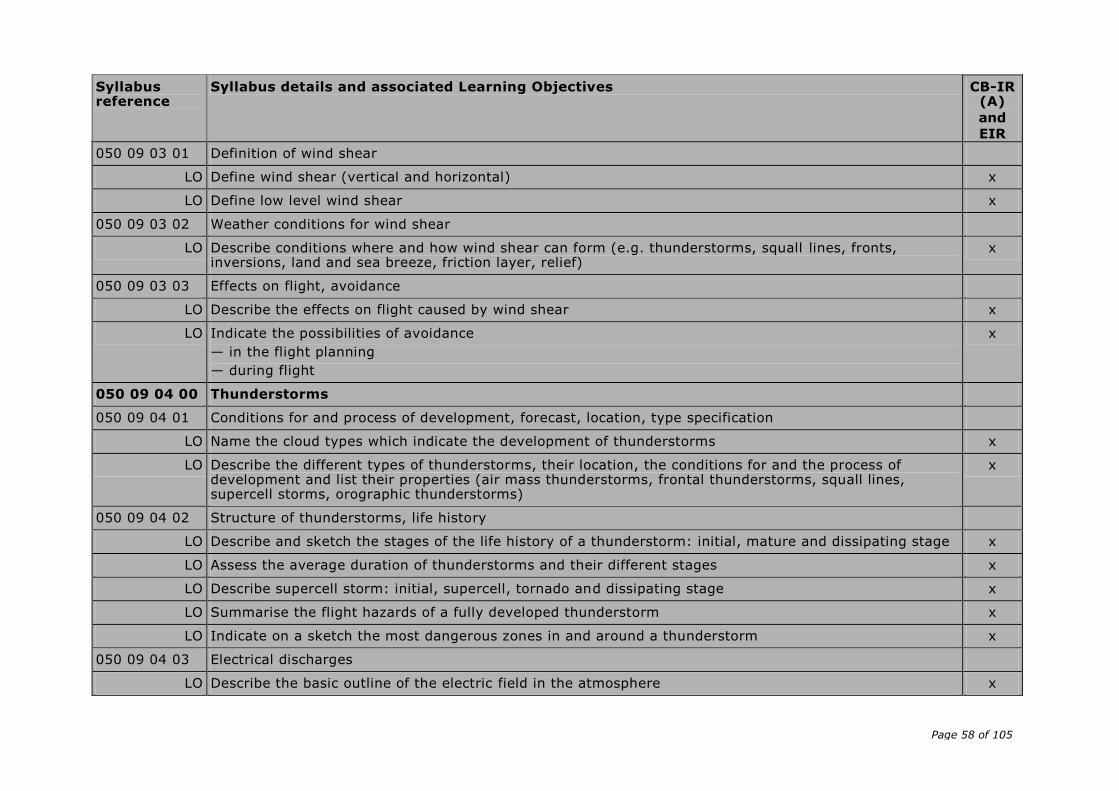
Page 58 of 105
Syllabus reference
Syllabus details and associated Learning Objectives CB-IR (A)
and
EIR
050 09 03 01 Definition of wind shear
LO Define wind shear (vertical and horizontal) x
LO Define low level wind shear x
050 09 03 02 Weather conditions for wind shear
LO Describe conditions where and how wind shear can form (e.g. thunderstorms, squall lines, fronts, inversions, land and sea breeze, friction layer, relief)
x
050 09 03 03 Effects on flight, avoidance
LO Describe the effects on flight caused by wind shear x
LO Indicate the possibilities of avoidance
— in the flight planning
— during flight
x
050 09 04 00 Thunderstorms
050 09 04 01 Conditions for and process of development, forecast, location, type specification
LO Name the cloud types which indicate the development of thunderstorms x
LO Describe the different types of thunderstorms, their location, the conditions for and the process of development and list their properties (air mass thunderstorms, frontal thunderstorms, squall lines, supercell storms, orographic thunderstorms)
x
050 09 04 02 Structure of thunderstorms, life history
LO Describe and sketch the stages of the life history of a thunderstorm: initial, mature and dissipating stage x
LO Assess the average duration of thunderstorms and their different stages x
LO Describe supercell storm: initial, supercell, tornado and dissipating stage x
LO Summarise the flight hazards of a fully developed thunderstorm x
LO Indicate on a sketch the most dangerous zones in and around a thunderstorm x
050 09 04 03 Electrical discharges
LO Describe the basic outline of the electric field in the atmosphere x

Page 59 of 105
Syllabus reference
Syllabus details and associated Learning Objectives CB-IR (A)
and
EIR
LO Describe the electrical potential differences in and around a thunderstorm x
LO Describe and asses ‘St. Elmo’s fire’ x
LO Describe the development of lightning discharges x
LO Describe the effect of lightning strike on aircraft and flight execution x
050 09 04 04 Development and effects of downbursts
LO Define the term downburst x
LO Distinguish between macroburst and microburst x
LO State the weather situations leading to the formation of downbursts x
LO Describe the process of development of a downburst x
LO Give the typical duration of a downburst x
LO Describe the effects of downbursts x
050 09 04 05 Thunderstorm avoidance
LO Explain how the pilot can anticipate each type of thunderstorms: pre-flight weather briefing, observation in flight, use of specific meteorological information, use of information given by ground weather radar and by airborne weather radar (Refer to 050 10 01 04), use of the stormscope (lightning detector)
x
LO Describe practical examples of flight techniques used to avoid the hazards of thunderstorms x
050 09 05 00 Tornadoes
050 09 05 01 Properties and occurrence
LO Define the tornado x
050 09 06 00 Inversions
050 09 06 01 Influence on aircraft performance
LO Explain the influence of inversions on the aircraft performance x
LO Compare the flight hazards during take-off and approach associated to a strong inversion alone and to a strong inversion combined with marked wind shear
x
050 09 08 00 Hazards in mountainous areas
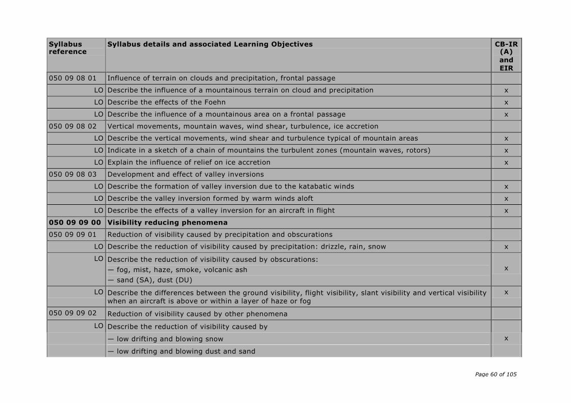
Page 60 of 105
Syllabus reference
Syllabus details and associated Learning Objectives CB-IR (A)
and
EIR
050 09 08 01 Influence of terrain on clouds and precipitation, frontal passage
LO Describe the influence of a mountainous terrain on cloud and precipitation x
LO Describe the effects of the Foehn x
LO Describe the influence of a mountainous area on a frontal passage x
050 09 08 02 Vertical movements, mountain waves, wind shear, turbulence, ice accretion
LO Describe the vertical movements, wind shear and turbulence typical of mountain areas x
LO Indicate in a sketch of a chain of mountains the turbulent zones (mountain waves, rotors) x
LO Explain the influence of relief on ice accretion x
050 09 08 03 Development and effect of valley inversions
LO Describe the formation of valley inversion due to the katabatic winds x
LO Describe the valley inversion formed by warm winds aloft x
LO Describe the effects of a valley inversion for an aircraft in flight x
050 09 09 00 Visibility reducing phenomena
050 09 09 01 Reduction of visibility caused by precipitation and obscurations
LO Describe the reduction of visibility caused by precipitation: drizzle, rain, snow x
LO Describe the reduction of visibility caused by obscurations:
— fog, mist, haze, smoke, volcanic ash
— sand (SA), dust (DU)
x
LO Describe the differences between the ground visibility, flight visibility, slant visibility and vertical visibility
when an aircraft is above or within a layer of haze or fog
x
050 09 09 02 Reduction of visibility caused by other phenomena
LO Describe the reduction of visibility caused by
— low drifting and blowing snow x
— low drifting and blowing dust and sand

Page 61 of 105
Syllabus reference
Syllabus details and associated Learning Objectives CB-IR (A)
and
EIR
— duststorm (DS) and sandstorm (SS)
— icing (windshield) x
— the position of the sun relative to the visual direction x
— the reflection of sun’s rays from the top of layers of haze, fog and clouds x
050 10 00 00 METEOROLOGICAL INFORMATION
050 10 01 00 Observation
050 10 01 01 Surface observations
LO Define visibility x
LO Describe the mereorological measurement of visibility x
LO Define prevailing visibility x
LO Define ground visibility x
LO List the units used for visibility (m, km) x
LO Define runway visual range x
LO Describe the meteorological measurement of runway visual range x
LO Indicate where the transmissometers/forward-scatter meters are placed on the airport x
LO List the units used for runway visual range (m) x
LO List the different possibilities to transmit information about runway visual range to pilots x
LO Compare visibility and runway visual range x
LO List the clouds considered in meteorological reports, and how they are indicated in METARs (TCU, CB) x
LO Define oktas x
LO Define cloud base x
LO Define ceiling x
LO Name the unit and the reference level used for information about cloud base (ft) x
LO Define vertical visibility x
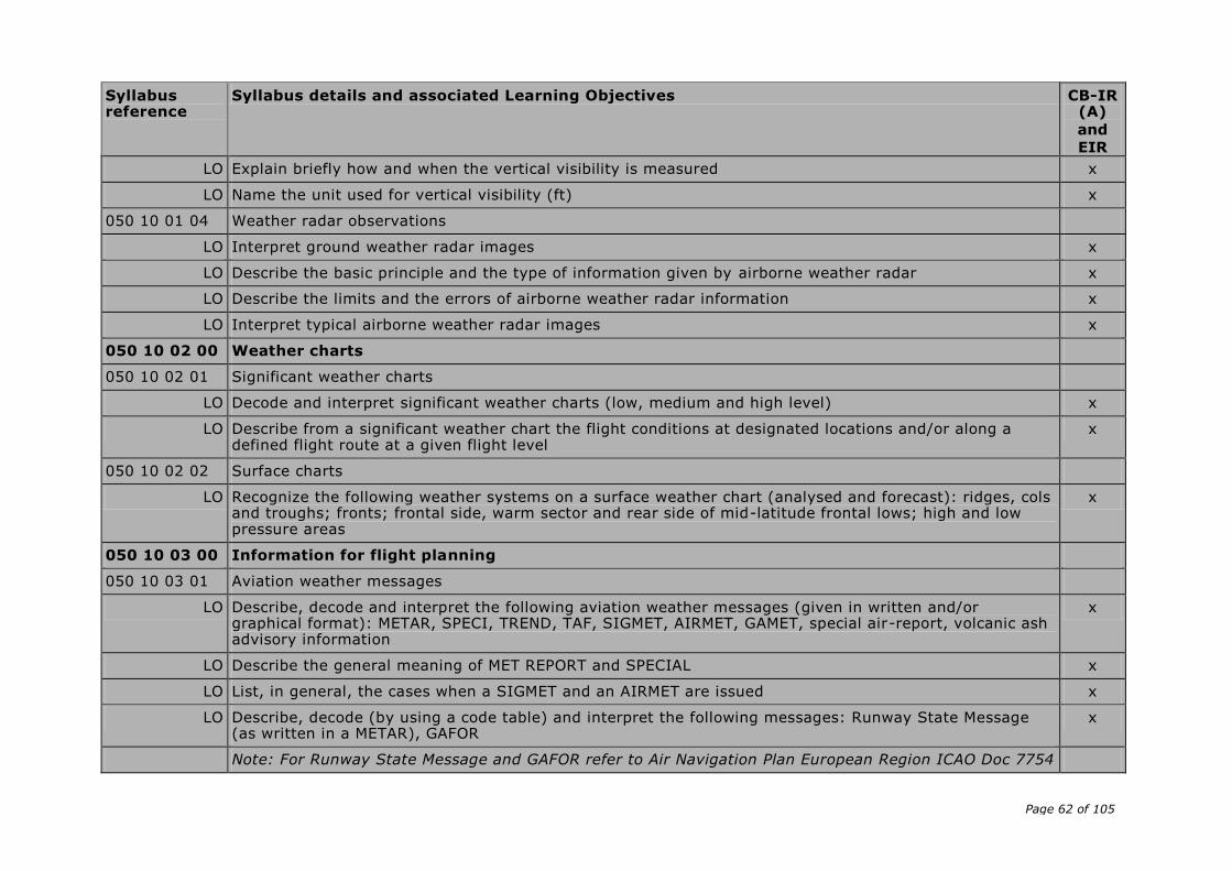
Page 62 of 105
Syllabus reference
Syllabus details and associated Learning Objectives CB-IR (A)
and
EIR
LO Explain briefly how and when the vertical visibility is measured x
LO Name the unit used for vertical visibility (ft) x
050 10 01 04 Weather radar observations
LO Interpret ground weather radar images x
LO Describe the basic principle and the type of information given by airborne weather radar x
LO Describe the limits and the errors of airborne weather radar information x
LO Interpret typical airborne weather radar images x
050 10 02 00 Weather charts
050 10 02 01 Significant weather charts
LO Decode and interpret significant weather charts (low, medium and high level) x
LO Describe from a significant weather chart the flight conditions at designated locations and/or along a defined flight route at a given flight level
x
050 10 02 02 Surface charts
LO Recognize the following weather systems on a surface weather chart (analysed and forecast): ridges, cols and troughs; fronts; frontal side, warm sector and rear side of mid-latitude frontal lows; high and low pressure areas
x
050 10 03 00 Information for flight planning
050 10 03 01 Aviation weather messages
LO Describe, decode and interpret the following aviation weather messages (given in written and/or graphical format): METAR, SPECI, TREND, TAF, SIGMET, AIRMET, GAMET, special air-report, volcanic ash advisory information
x
LO Describe the general meaning of MET REPORT and SPECIAL x
LO List, in general, the cases when a SIGMET and an AIRMET are issued x
LO Describe, decode (by using a code table) and interpret the following messages: Runway State Message (as written in a METAR), GAFOR
x
Note: For Runway State Message and GAFOR refer to Air Navigation Plan European Region ICAO Doc 7754
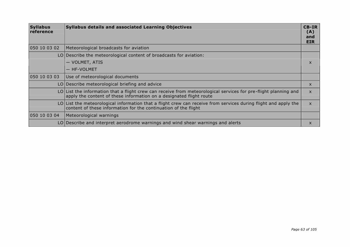
Page 63 of 105
Syllabus reference
Syllabus details and associated Learning Objectives CB-IR (A)
and
EIR
050 10 03 02 Meteorological broadcasts for aviation
LO Describe the meteorological content of broadcasts for aviation:
— VOLMET, ATIS x
— HF-VOLMET
050 10 03 03 Use of meteorological documents
LO Describe meteorological briefing and advice x
LO List the information that a flight crew can receive from meteorological services for pre-flight planning and apply the content of these information on a designated flight route
x
LO List the meteorological information that a flight crew can receive from services during flight and apply the content of these information for the continuation of the flight
x
050 10 03 04 Meteorological warnings
LO Describe and interpret aerodrome warnings and wind shear warnings and alerts x
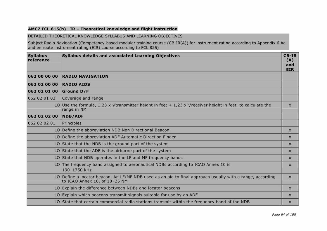
Page 64 of 105
AMC7 FCL.615(b) IR – Theoretical knowledge and flight instruction
DETAILED THEORETICAL KNOWLEDGE SYLLABUS AND LEARNING OBJECTIVES
Subject Radio Navigation (Competency-based modular training course (CB-IR(A)) for instrument rating according to Appendix 6 Aa and en route instrument rating (EIR) course according to FCL.825)
Syllabus reference
Syllabus details and associated Learning Objectives CB-IR (A)
and
EIR
062 00 00 00 RADIO NAVIGATION
062 02 00 00 RADIO AIDS
062 02 01 00 Ground D/F
062 02 01 03 Coverage and range
LO Use the formula, 1,23 x √transmitter height in feet + 1,23 x √receiver height in feet, to calculate the range in NM
x
062 02 02 00 NDB/ADF
062 02 02 01 Principles
LO Define the abbreviation NDB Non Directional Beacon x
LO Define the abbreviation ADF Automatic Direction Finder x
LO State that the NDB is the ground part of the system x
LO State that the ADF is the airborne part of the system x
LO State that NDB operates in the LF and MF frequency bands x
LO The frequency band assigned to aeronautical NDBs according to ICAO Annex 10 is
190–1750 kHz
x
LO Define a locator beacon. An LF/MF NDB used as an aid to final approach usually with a range, according to ICAO Annex 10, of 10–25 NM
x
LO Explain the difference between NDBs and locator beacons x
LO Explain which beacons transmit signals suitable for use by an ADF x
LO State that certain commercial radio stations transmit within the frequency band of the NDB x
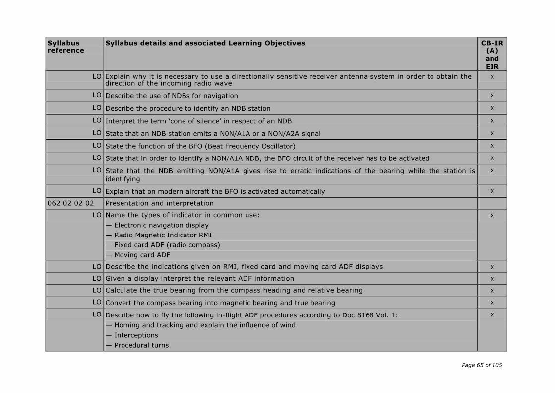
Page 65 of 105
Syllabus reference
Syllabus details and associated Learning Objectives CB-IR (A)
and
EIR
LO Explain why it is necessary to use a directionally sensitive receiver antenna system in order to obtain the direction of the incoming radio wave
x
LO Describe the use of NDBs for navigation x
LO Describe the procedure to identify an NDB station x
LO Interpret the term ‘cone of silence’ in respect of an NDB x
LO State that an NDB station emits a N0N/A1A or a NON/A2A signal x
LO State the function of the BFO (Beat Frequency Oscillator) x
LO State that in order to identify a NON/A1A NDB, the BFO circuit of the receiver has to be activated x
LO State that the NDB emitting NON/A1A gives rise to erratic indications of the bearing while the station is
identifying
x
LO Explain that on modern aircraft the BFO is activated automatically x
062 02 02 02 Presentation and interpretation
LO Name the types of indicator in common use:
— Electronic navigation display
— Radio Magnetic Indicator RMI
— Fixed card ADF (radio compass)
— Moving card ADF
x
LO Describe the indications given on RMI, fixed card and moving card ADF displays x
LO Given a display interpret the relevant ADF information x
LO Calculate the true bearing from the compass heading and relative bearing x
LO Convert the compass bearing into magnetic bearing and true bearing x
LO Describe how to fly the following in-flight ADF procedures according to Doc 8168 Vol. 1:
— Homing and tracking and explain the influence of wind
— Interceptions
— Procedural turns
x
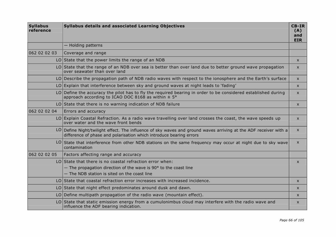
Page 66 of 105
Syllabus reference
Syllabus details and associated Learning Objectives CB-IR (A)
and
EIR
— Holding patterns
062 02 02 03 Coverage and range
LO State that the power limits the range of an NDB x
LO State that the range of an NDB over sea is better than over land due to better ground wave propagation over seawater than over land
x
LO Describe the propagation path of NDB radio waves with respect to the ionosphere and the Earth’s surface x
LO Explain that interference between sky and ground waves at night leads to ‘fading’ x
LO Define the accuracy the pilot has to fly the required bearing in order to be considered established during approach according to ICAO DOC 8168 as within ± 5°
x
LO State that there is no warning indication of NDB failure x
062 02 02 04 Errors and accuracy
LO Explain Coastal Refraction. As a radio wave travelling over land crosses the coast, the wave speeds up over water and the wave front bends
x
LO Define Night/twilight effect. The influence of sky waves and ground waves arriving at the ADF receiver with a
difference of phase and polarisation which introduce bearing errors
x
LO State that interference from other NDB stations on the same frequency may occur at night due to sky wave
contamination
x
062 02 02 05 Factors affecting range and accuracy
LO State that there is no coastal refraction error when:
— The propagation direction of the wave is 90° to the coast line
— The NDB station is sited on the coast line
x
LO State that coastal refraction error increases with increased incidence. x
LO State that night effect predominates around dusk and dawn. x
LO Define multipath propagation of the radio wave (mountain effect). x
LO State that static emission energy from a cumulonimbus cloud may interfere with the radio wave and influence the ADF bearing indication.
x

Page 67 of 105
Syllabus reference
Syllabus details and associated Learning Objectives CB-IR (A)
and
EIR
062 02 03 00 VOR and Doppler-VOR
062 02 03 01 Principles
LO State that the frequency band allocated to VOR according to ICAO Annex 10 is VHF and the frequencies used are 108.0–117.975 MHz.
x
LO State that frequencies in the allocated VOR range with the first decimal place an odd number, are used by ILS
x
LO State that the following types of VOR are in operation:
— Conventional VOR (CVOR) a first generation VOR station emitting signals by means of a rotating antenna
— Doppler VOR (DVOR) a second generation VOR station emitting signals by means of a combination of fixed
antennas utilising the Doppler principle
— En-route VOR for use by IFR traffic
— Terminal VOR (TVOR) a station with a shorter range used as part of the approach and departure structure
at major airports
— Test VOR (VOT) a VOR station emitting a signal to test VOR indicators in an aircraft
x
LO Describe how ATIS information is transmitted on VOR frequencies. x
LO List the three main components of VOR airborne equipment:
— The antenna
— The receiver
— The indicator
x
LO Describe the identification of a VOR in terms of Morse-code letters, continuous tone or dots (VOT), tone pitch, repetition rate and additional plain text
x
LO State that failure of the VOR station to stay within the required limits can cause the removal of identification and navigation components from the carrier or radiation to cease
x
062 02 03 02 Presentation and interpretation
LO Read off the radial on a Radio Magnetic Indicator (RMI) x
LO Read off the angular displacement, in relation to a pre-selected radial on an HSI or CDI x
LO Explain the use of the TO/FROM indicator in order to determine aircraft position relative to the VOR x
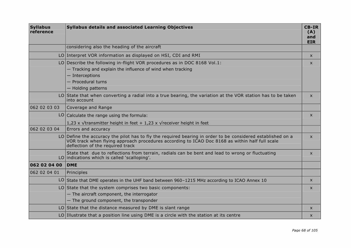
Page 68 of 105
Syllabus reference
Syllabus details and associated Learning Objectives CB-IR (A)
and
EIR considering also the heading of the aircraft
LO Interpret VOR information as displayed on HSI, CDI and RMI x
LO Describe the following in-flight VOR procedures as in DOC 8168 Vol.1:
— Tracking and explain the influence of wind when tracking
— Interceptions
— Procedural turns
— Holding patterns
x
LO State that when converting a radial into a true bearing, the variation at the VOR station has to be taken into account
x
062 02 03 03 Coverage and Range
LO Calculate the range using the formula:
1,23 x √transmitter height in feet + 1,23 x √receiver height in feet
x
062 02 03 04 Errors and accuracy
LO Define the accuracy the pilot has to fly the required bearing in order to be considered established on a VOR track when flying approach procedures according to ICAO Doc 8168 as within half full scale deflection of the required track
x
LO
State that due to reflections from terrain, radials can be bent and lead to wrong or fluctuating indications which is called ‘scalloping’.
x
062 02 04 00 DME
062 02 04 01 Principles
LO State that DME operates in the UHF band between 960–1215 MHz according to ICAO Annex 10 x
LO State that the system comprises two basic components:
— The aircraft component, the interrogator
— The ground component, the transponder
x
LO State that the distance measured by DME is slant range x
LO Illustrate that a position line using DME is a circle with the station at its centre x
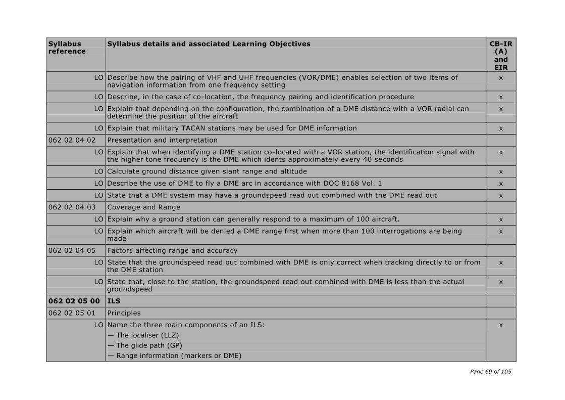
Page 69 of 105
Syllabus reference
Syllabus details and associated Learning Objectives CB-IR (A)
and
EIR
LO Describe how the pairing of VHF and UHF frequencies (VOR/DME) enables selection of two items of navigation information from one frequency setting
x
LO Describe, in the case of co-location, the frequency pairing and identification procedure x
LO Explain that depending on the configuration, the combination of a DME distance with a VOR radial can determine the position of the aircraft
x
LO Explain that military TACAN stations may be used for DME information x
062 02 04 02 Presentation and interpretation
LO Explain that when identifying a DME station co-located with a VOR station, the identification signal with the higher tone frequency is the DME which idents approximately every 40 seconds
x
LO Calculate ground distance given slant range and altitude x
LO Describe the use of DME to fly a DME arc in accordance with DOC 8168 Vol. 1 x
LO State that a DME system may have a groundspeed read out combined with the DME read out x
062 02 04 03 Coverage and Range
LO Explain why a ground station can generally respond to a maximum of 100 aircraft. x
LO Explain which aircraft will be denied a DME range first when more than 100 interrogations are being made
x
062 02 04 05 Factors affecting range and accuracy
LO State that the groundspeed read out combined with DME is only correct when tracking directly to or from the DME station
x
LO State that, close to the station, the groundspeed read out combined with DME is less than the actual groundspeed
x
062 02 05 00 ILS
062 02 05 01 Principles
LO Name the three main components of an ILS:
— The localiser (LLZ)
— The glide path (GP)
— Range information (markers or DME)
x
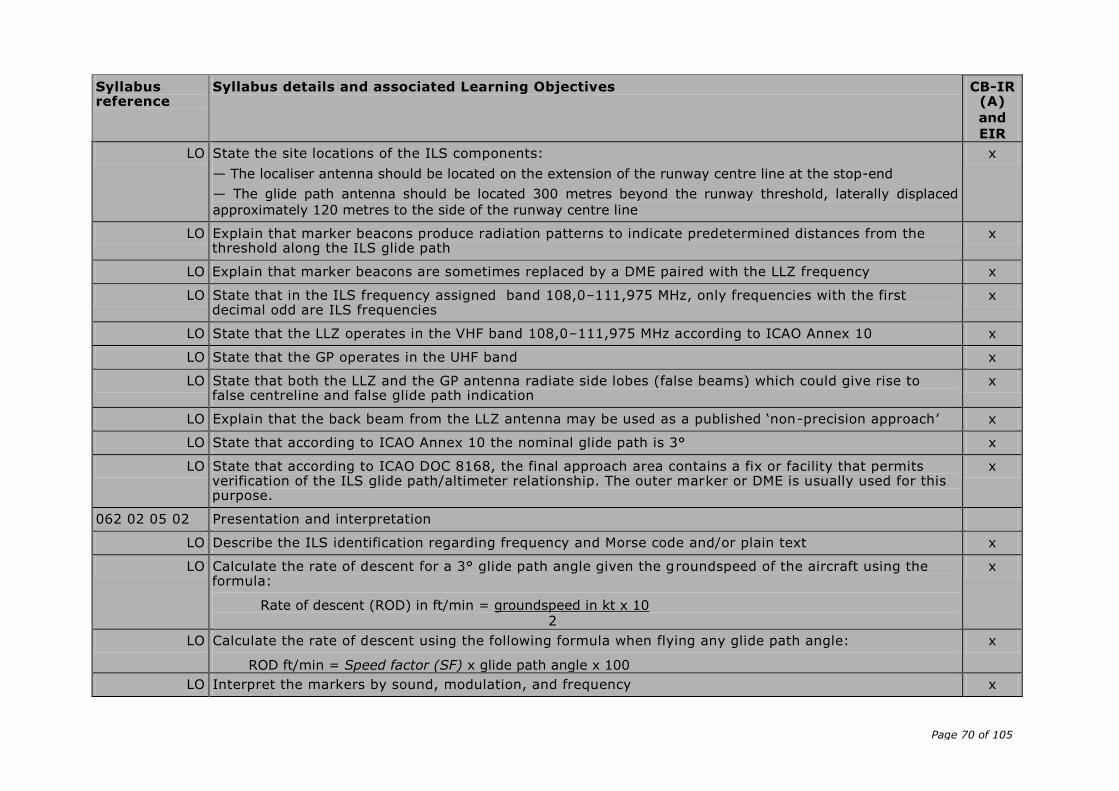
Page 70 of 105
Syllabus reference
Syllabus details and associated Learning Objectives CB-IR (A)
and
EIR
LO State the site locations of the ILS components:
— The localiser antenna should be located on the extension of the runway centre line at the stop-end
— The glide path antenna should be located 300 metres beyond the runway threshold, laterally displaced
approximately 120 metres to the side of the runway centre line
x
LO Explain that marker beacons produce radiation patterns to indicate predetermined distances from the threshold along the ILS glide path
x
LO Explain that marker beacons are sometimes replaced by a DME paired with the LLZ frequency x
LO State that in the ILS frequency assigned band 108,0–111,975 MHz, only frequencies with the first decimal odd are ILS frequencies
x
LO State that the LLZ operates in the VHF band 108,0–111,975 MHz according to ICAO Annex 10 x
LO State that the GP operates in the UHF band x
LO State that both the LLZ and the GP antenna radiate side lobes (false beams) which could give rise to false centreline and false glide path indication
x
LO Explain that the back beam from the LLZ antenna may be used as a published ‘non-precision approach’ x
LO State that according to ICAO Annex 10 the nominal glide path is 3° x
LO State that according to ICAO DOC 8168, the final approach area contains a fix or facility that permits verification of the ILS glide path/altimeter relationship. The outer marker or DME is usually used for this purpose.
x
062 02 05 02 Presentation and interpretation
LO Describe the ILS identification regarding frequency and Morse code and/or plain text x
LO Calculate the rate of descent for a 3° glide path angle given the groundspeed of the aircraft using the formula:
Rate of descent (ROD) in ft/min = groundspeed in kt x 10 2
x
LO Calculate the rate of descent using the following formula when flying any glide path angle:
ROD ft/min = Speed factor (SF) x glide path angle x 100
x
LO Interpret the markers by sound, modulation, and frequency x
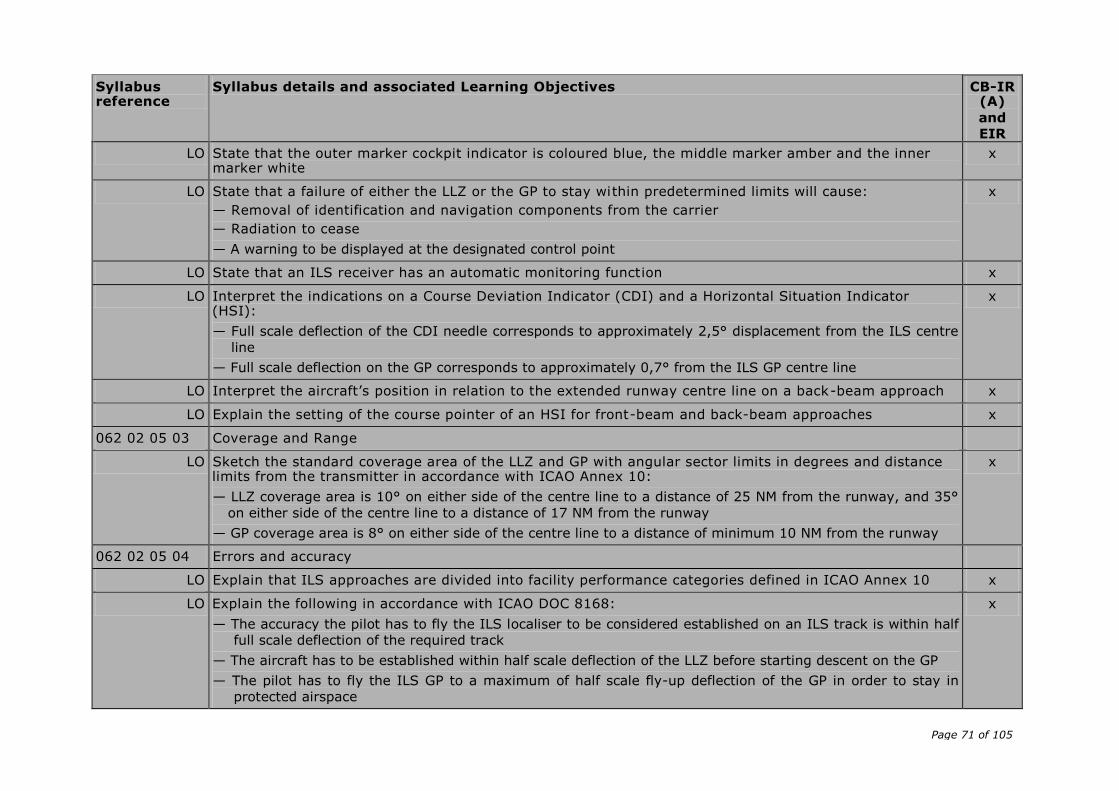
Page 71 of 105
Syllabus reference
Syllabus details and associated Learning Objectives CB-IR (A)
and
EIR
LO State that the outer marker cockpit indicator is coloured blue, the middle marker amber and the inner marker white
x
LO State that a failure of either the LLZ or the GP to stay within predetermined limits will cause:
— Removal of identification and navigation components from the carrier
— Radiation to cease
— A warning to be displayed at the designated control point
x
LO State that an ILS receiver has an automatic monitoring function x
LO Interpret the indications on a Course Deviation Indicator (CDI) and a Horizontal Situation Indicator (HSI):
— Full scale deflection of the CDI needle corresponds to approximately 2,5° displacement from the ILS centre
line
— Full scale deflection on the GP corresponds to approximately 0,7° from the ILS GP centre line
x
LO Interpret the aircraft’s position in relation to the extended runway centre line on a back-beam approach x
LO Explain the setting of the course pointer of an HSI for front-beam and back-beam approaches x
062 02 05 03 Coverage and Range
LO Sketch the standard coverage area of the LLZ and GP with angular sector limits in degrees and distance limits from the transmitter in accordance with ICAO Annex 10:
— LLZ coverage area is 10° on either side of the centre line to a distance of 25 NM from the runway, and 35°
on either side of the centre line to a distance of 17 NM from the runway
— GP coverage area is 8° on either side of the centre line to a distance of minimum 10 NM from the runway
x
062 02 05 04 Errors and accuracy
LO Explain that ILS approaches are divided into facility performance categories defined in ICAO Annex 10 x
LO Explain the following in accordance with ICAO DOC 8168:
— The accuracy the pilot has to fly the ILS localiser to be considered established on an ILS track is within half
full scale deflection of the required track
— The aircraft has to be established within half scale deflection of the LLZ before starting descent on the GP
— The pilot has to fly the ILS GP to a maximum of half scale fly-up deflection of the GP in order to stay in
protected airspace
x
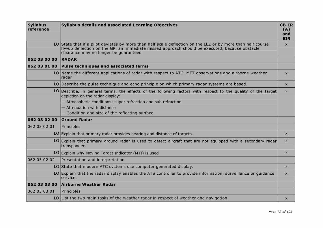
Page 72 of 105
Syllabus reference
Syllabus details and associated Learning Objectives CB-IR (A)
and
EIR
LO State that if a pilot deviates by more than half scale deflection on the LLZ or by more than half course fly-up deflection on the GP, an immediate missed approach should be executed, because obstacle clearance may no longer be guaranteed
x
062 03 00 00 RADAR
062 03 01 00 Pulse techniques and associated terms
LO Name the different applications of radar with respect to ATC, MET observations and airborne weather radar
x
LO Describe the pulse technique and echo principle on which primary radar systems are based. x
LO Describe, in general terms, the effects of the following factors with respect to the quality of the target
depiction on the radar display:
— Atmospheric conditions; super refraction and sub refraction
— Attenuation with distance
— Condition and size of the reflecting surface
x
062 03 02 00 Ground Radar
062 03 02 01 Principles
LO Explain that primary radar provides bearing and distance of targets. x
LO Explain that primary ground radar is used to detect aircraft that are not equipped with a secondary radar
transponder.
x
LO Explain why Moving Target Indicator (MTI) is used x
062 03 02 02 Presentation and interpretation
LO State that modern ATC systems use computer generated display. x
LO Explain that the radar display enables the ATS controller to provide information, surveillance or guidance service.
x
062 03 03 00 Airborne Weather Radar
062 03 03 01 Principles
LO List the two main tasks of the weather radar in respect of weather and navigation x

Page 73 of 105
Syllabus reference
Syllabus details and associated Learning Objectives CB-IR (A)
and
EIR
LO Explain how the antenna is attitude-stabilised in relation to the horizontal plane using the aircraft's attitude reference system
x
LO Describe the cone shaped pencil beam of about 3° to 5° beam width used for weather depiction x
LO Explain that in modern AWRs a single radiation pattern is used for both mapping and weather with the scanning angle being changed between them
x
062 03 03 02 Presentation and interpretation
LO Explain the functions of the following different modes on the radar control panel
— Off/on switch
— Function switch, with modes WX, WX+T and MAP.
— Gain control setting (auto/manual)
— Tilt/auto tilt switch.
x
LO Name, for areas of differing reflection intensity, the colour gradations (green, yellow, red and magenta)
indicating the increasing intensity of precipitation
x
LO Illustrate the use of azimuth marker lines and range lines in respect of the relative bearing and the distance to
a thunderstorm or to a landmark on the screen
x
062 03 03 03 Coverage and Range
LO Explain how the radar is used for weather detection and for mapping (range, tilt and gain if available) x
062 03 03 04 Errors, accuracy, limitations
LO Explain why AWR should be used with extreme caution when on the ground x
062 03 03 05 Factors affecting range and accuracy
LO Explain the danger of the area behind heavy rain (shadow area) where no radar waves will penetrate x
LO Explain why the tilt setting should be higher when the aircraft descends to a lower altitude x
LO Explain why the tilt setting should be lower when the aircraft climbs to a higher altitude x
LO Explain why a thunderstorm may not be detected when the tilt is set too high x
062 03 03 06 Application for navigation
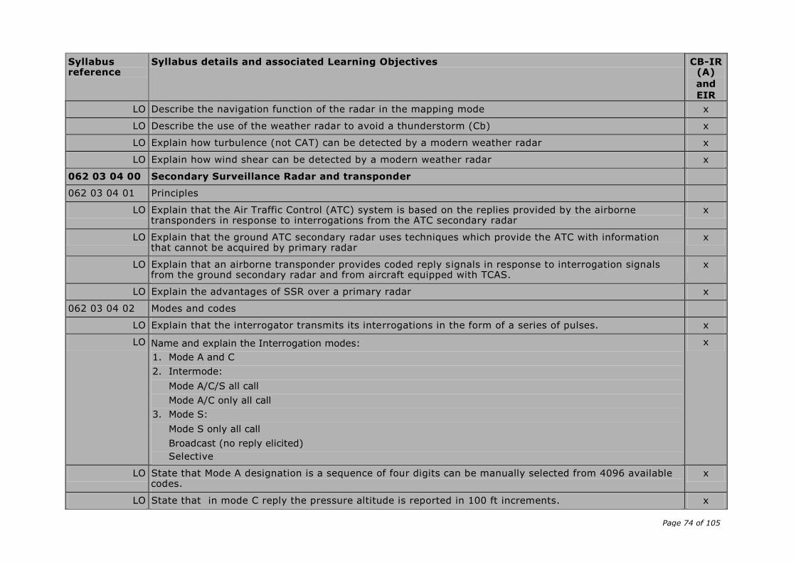
Page 74 of 105
Syllabus reference
Syllabus details and associated Learning Objectives CB-IR (A)
and
EIR
LO Describe the navigation function of the radar in the mapping mode x
LO Describe the use of the weather radar to avoid a thunderstorm (Cb) x
LO Explain how turbulence (not CAT) can be detected by a modern weather radar x
LO Explain how wind shear can be detected by a modern weather radar x
062 03 04 00 Secondary Surveillance Radar and transponder
062 03 04 01 Principles
LO Explain that the Air Traffic Control (ATC) system is based on the replies provided by the airborne transponders in response to interrogations from the ATC secondary radar
x
LO Explain that the ground ATC secondary radar uses techniques which provide the ATC with information that cannot be acquired by primary radar
x
LO Explain that an airborne transponder provides coded reply signals in response to interrogation signals from the ground secondary radar and from aircraft equipped with TCAS.
x
LO Explain the advantages of SSR over a primary radar x
062 03 04 02 Modes and codes
LO Explain that the interrogator transmits its interrogations in the form of a series of pulses. x
LO Name and explain the Interrogation modes:
1. Mode A and C
2. Intermode:
Mode A/C/S all call
Mode A/C only all call
3. Mode S:
Mode S only all call
Broadcast (no reply elicited)
Selective
x
LO State that Mode A designation is a sequence of four digits can be manually selected from 4096 available codes.
x
LO State that in mode C reply the pressure altitude is reported in 100 ft increments. x
Page 75 of 105
Syllabus reference
Syllabus details and associated Learning Objectives CB-IR (A)
and
EIR
LO State that in addition to the information pulses provided, a special position identification pulse (SPI) can be transmitted but only as a result of a manual selection (IDENT)
x
LO Explain the need for compatibility of Mode S with Mode A and C x
LO Explain that the Mode S transponders receive interrogations from other Mode S transponders and SSR ground stations
x
LO State that Mode S surveillance protocols implicitly use the principle of selective addressing x
LO Explain that every aircraft will have been allocated an ICAO Aircraft Address which is hard coded into the airframe (Mode S address)
x
LO Interpret the following mode S terms:
— Selective addressing
— Mode ‘all call’
— Selective call
x
LO State that Mode S interrogation contains either:
— Aircraft address
— All-call address
— Broadcast address
x
LO State that the Aircraft Address shall be transmitted in any reply except in Mode S only all-call reply x
062 03 04 03 Presentation and interpretation
LO Explain how an aircraft can be identified by a unique code x
LO Illustrate how the following information is presented on the radar screen:
— Pressure altitude
— Flight level
— Flight number or aircraft registration
— Ground speed
x
LO Name and interpret the codes 7700, 7600 and 7500 x
LO Interpret the selector modes: OFF, Standby, ON (mode A), ALT (mode A and C) and TEST x
Page 76 of 105
Syllabus reference
Syllabus details and associated Learning Objectives CB-IR (A)
and
EIR
LO Explain the function of the emission of a SPI (Special Position Identification) pulse after pushing the IDENT button in the aircraft
x
ELEMENTARY SURVEILLANCE
LO Explain that the elementary surveillance provides the ATC controller with aircraft position, altitude and identification
x
LO State that the elementary surveillance needs MODE S transponders with surveillance identifier (SI) code capacity and the automatic reporting of aircraft identification, known as ICAO level 2s
x
LO State that the SI code must correspond to the aircraft identification specified in item 7 of the ICAO flight plan or to the registration marking
x
062 03 04 04 Errors and Accuracy
LO Explain the following disadvantages of SSR (mode A/C):
— Code garbling of aircraft less than 1.7 NM apart measured in the vertical plane perpendicular to and from
the antenna
— ‘Fruiting’ which results from reception of replies caused by interrogations from other radar stations
x
062 05 00 00 AREA NAVIGATION SYSTEMS, RNAV/FMS
062 05 01 00 General philosophy and definitions
062 05 01 01 Basic RNAV (B-RNAV)/precision RNAV (P-RNAV)/ RNP-PNAV
LO Define area navigation RNAV (ICAO Annex 11). A method of navigation permitting aircraft operations on any desired track within the coverage of station-referenced navigation signal, or within the limits of a self-contained navigation system
x
LO State that basic RNAV (B-RNAV) systems require RNP 5 x
LO State that precision RNAV (PRNAV) systems require RNP 1 x
062 05 01 02 Principles of 2D RNAV, 3D RNAV and 4D RNAV
LO State that a 2D RNAV system is able to navigate in the horizontal plane only. x
LO State that a 3D RNAV system is able to navigate in the horizontal plane and in addition has a guidance capability in the vertical plane.
x
LO State that a 4D RNAV system is able to navigate in the horizontal plane, has a guidance capability in the x
Page 77 of 105
Syllabus reference
Syllabus details and associated Learning Objectives CB-IR (A)
and
EIR vertical plane and in addition has a timing function
062 05 01 03 Required Navigation Performance (RNP) in accordance with ICAO DOC 9613
LO State that RNP is a concept that applies to navigation performance within an airspace x
LO The RNP type is based on the navigation performance accuracy to be achieved within the airspace. x
LO State that RNP X requires a navigation performance accuracy of X NM both lateral and longitudinal 95 % of the flying time. (RNP 1 requires a navigation performance of 1 NM both lateral and longitudinal 95 % of the flying time)
x
LO State that RNAV equipment is one requirement, in order to receive approval to operate in a RNP environment
x
LO State that RNAV equipment operates by automatically determining the aircraft position. x
LO State the advantages of using RNAV techniques over more conventional forms of navigation:
— Establishment of more direct routes permitting a reduction in flight distance
— Establishment of dual or parallel routes to accommodate a greater flow of en-route traffic
— Establishment of bypass routes for aircraft over flying high-density terminal areas
— Establishment of alternatives or contingency routes on either a planned or ad hoc basis
— Establishment of optimum locations for holding patterns
— Reduction in the number of ground navigation facilities
x
LO State that RNP may be specified for a route, a number of routes, an area, volume of airspace or any airspace of defined dimensions.
x
LO State that airborne navigation equipment uses inputs from navigational systems such as VOR/DME, DME/DME, GNSS, INS and IRS.
x
LO State that aircraft equipped to operate to RNP 1 and better, should be able to compute an estimate of its position error, depending on the sensors being used and time elapsed
x
LO Indicate navigation equipment failure. x
062 05 02 00 Simple 2D RNAV
Info:
First generation of radio navigation systems allowing the flight crew to select a phantom waypoint on the
Page 78 of 105
Syllabus reference
Syllabus details and associated Learning Objectives CB-IR (A)
and
EIR RNAV panel and select a desired track to fly inbound to the waypoint.
062 05 02 01 Flight deck equipment
LO The control unit allows the flight crew to:
— Tune the VOR/DME station used to define the phantom waypoint
— Define the phantom waypoint as a radial and distance (DME) form the selected VOR/DME station
— Select desired magnetic track to follow inbound to the phantom waypoint
— Select between an en-route mode, an approach mode of operation and the basic VOR/DME mode of operation
x
LO Track guidance is shown on the HSI/CDI. x
062 05 02 02 Navigation computer, VOR/DME navigation
LO The navigation computer of the simple 2D RNAV system computes the navigational problems by simple sine and cosine mathematics, solving the triangular problems.
x
062 05 02 03 Navigation computer input/output
LO State the following input data to the navigation computer is:
— Actual VOR radial and DME distance from selected VOR station
— Radial and distance to phantom waypoint
— Desired magnetic track inbound to the phantom waypoint
x
LO State the following output data from the navigation computer:
— Desired magnetic track to the phantom waypoint shown on the CDI at the course pointer
— Distance from present position to the phantom waypoint
— Deviations from desired track as follows:
— In en-route mode full scale deflection on the CDI is 5 NM
— In approach mode full scale deflection on the CDI is 1¼ NM
— In VOR/DME mode full scale deflection of the CDI is 10.
x
LO State that the system is limited to operate within range of selected VOR/DME station x
062 05 03 00 4D RNAV

Page 79 of 105
Syllabus reference
Syllabus details and associated Learning Objectives CB-IR (A)
and
EIR
Info:
The next generation of area navigation equipment allowed the flight crew to navigate on any desired track
within coverage of VOR/DME stations
062 05 03 01 Flight deck equipment
LO State that in order to give the flight crew control over the required lateral guidance functions, RNAV
equipment should at least be able to perform the following functions:
Display present position in latitude/longitude or as distance/bearing to selected waypoint;
— Select or enter the required flight plan through the control and display unit (CDU);
— Review and modify navigation data for any part of a flight plan at any stage of flight and store sufficient
data to carry out the active flight plan;
— Review, assemble, modify or verify a flight plan in flight, without affecting the guidance output;
— Execute a modified flight plan only after positive action by the flight crew;
— Where provided, assemble and verify an alternative flight plan without affecting the active flight plan;
— Assemble a flight plan, either by identifier or by selection of individual waypoints from the database, or by
creation of waypoints from the database, or by creation of waypoints defined by latitude/longitude,
bearing/distance parameters or other parameters;
— Assemble flight plans by joining routes or route segments;
— Allow verification or adjustment of displayed position;
— Provide automatic sequencing through waypoints with turn anticipation. Manual sequencing should also be
provided to allow flight over, and return to, waypoints;
— Display cross-track error on the CDU;
— Provide time to waypoints on the CDU;
— Execute a direct clearance to any waypoint;
— Fly parallel tracks at the selected offset distance; offset mode should be clearly indicated;
— Purge previous radio updates;
— Carry out RNAV holding procedures (when defined);
— Make available to the flight crew estimates of positional uncertainty, either as a quality factor or by
reference to sensor differences from the computed position;
— Conform to WGS-84 geodetic reference system;
x
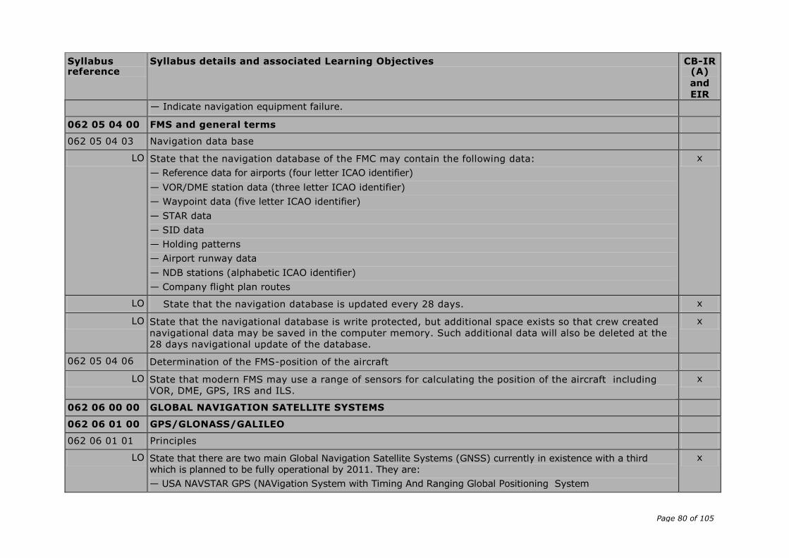
Page 80 of 105
Syllabus reference
Syllabus details and associated Learning Objectives CB-IR (A)
and
EIR
— Indicate navigation equipment failure.
062 05 04 00 FMS and general terms
062 05 04 03 Navigation data base
LO State that the navigation database of the FMC may contain the following data:
— Reference data for airports (four letter ICAO identifier)
— VOR/DME station data (three letter ICAO identifier)
— Waypoint data (five letter ICAO identifier)
— STAR data
— SID data
— Holding patterns
— Airport runway data
— NDB stations (alphabetic ICAO identifier)
— Company flight plan routes
x
LO State that the navigation database is updated every 28 days. x
LO State that the navigational database is write protected, but additional space exists so that crew created navigational data may be saved in the computer memory. Such additional data will also be deleted at the 28 days navigational update of the database.
x
062 05 04 06 Determination of the FMS-position of the aircraft
LO State that modern FMS may use a range of sensors for calculating the position of the aircraft including VOR, DME, GPS, IRS and ILS.
x
062 06 00 00 GLOBAL NAVIGATION SATELLITE SYSTEMS
062 06 01 00 GPS/GLONASS/GALILEO
062 06 01 01 Principles
LO State that there are two main Global Navigation Satellite Systems (GNSS) currently in existence with a third which is planned to be fully operational by 2011. They are:
— USA NAVSTAR GPS (NAVigation System with Timing And Ranging Global Positioning System
x

Page 81 of 105
Syllabus reference
Syllabus details and associated Learning Objectives CB-IR (A)
and
EIR
— Russian GLONASS (GLObal NAvigation Satellite System)
— European GALILEO
LO State that all 3 systems (will) consist of a constellation of satellites which can be used by a suitably equipped receiver to determine position
x
062 06 01 02 Operation
NAVSTAR GPS
LO State that there are currently two modes of operation, SPS (Standard Positioning Service) for civilian users, and PPS (Precise Positioning Service for authorised users
x
LO SPS was originally designed to provide civil users with a less accurate positioning capability than PPS x
LO Name the three segments as:
— Space segment
— Control segment
— User segment
x
Space segment
LO State that the space segment consists of a notional constellation of 24 operational satellites x
LO State that it takes 12½ minutes for a GPS receiver to receive all the data frames in the navigation message
x
LO State that the almanac contains the orbital data about all the satellites in the GPS constellation x
LO State that the ephemeris contains data used to correct the orbital data of the satellites due to small disturbances
x
LO State that the clock correction parameters are data for correction of the satellite time x
LO State that UTC parameters are factors determining the difference between GPS time and UTC x
LO State that an ionospheric model is currently used to calculate the time delay of the signal travelling through the ionosphere.
x
LO State that the GPS health message is used to exclude unhealthy satellites from the position solution. Satellite health is determined by the validity of the navigation data
x
LO State that GPS uses the WGS 84 model x
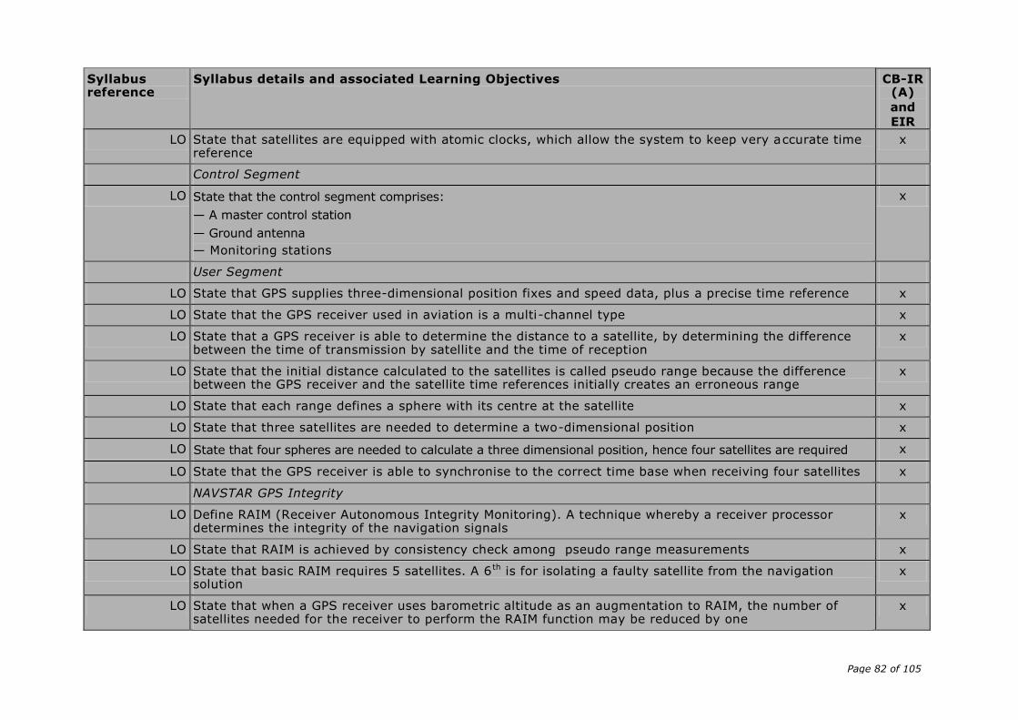
Page 82 of 105
Syllabus reference
Syllabus details and associated Learning Objectives CB-IR (A)
and
EIR
LO State that satellites are equipped with atomic clocks, which allow the system to keep very accurate time reference
x
Control Segment
LO State that the control segment comprises:
— A master control station
— Ground antenna
— Monitoring stations
x
User Segment
LO State that GPS supplies three-dimensional position fixes and speed data, plus a precise time reference x
LO State that the GPS receiver used in aviation is a multi-channel type x
LO State that a GPS receiver is able to determine the distance to a satellite, by determining the difference between the time of transmission by satellite and the time of reception
x
LO State that the initial distance calculated to the satellites is called pseudo range because the difference between the GPS receiver and the satellite time references initially creates an erroneous range
x
LO State that each range defines a sphere with its centre at the satellite x
LO State that three satellites are needed to determine a two-dimensional position x
LO State that four spheres are needed to calculate a three dimensional position, hence four satellites are required x
LO State that the GPS receiver is able to synchronise to the correct time base when receiving four satellites x
NAVSTAR GPS Integrity
LO Define RAIM (Receiver Autonomous Integrity Monitoring). A technique whereby a receiver processor determines the integrity of the navigation signals
x
LO State that RAIM is achieved by consistency check among pseudo range measurements x
LO State that basic RAIM requires 5 satellites. A 6 th is for isolating a faulty satellite from the navigation solution
x
LO State that when a GPS receiver uses barometric altitude as an augmentation to RAIM, the number of satellites needed for the receiver to perform the RAIM function may be reduced by one
x
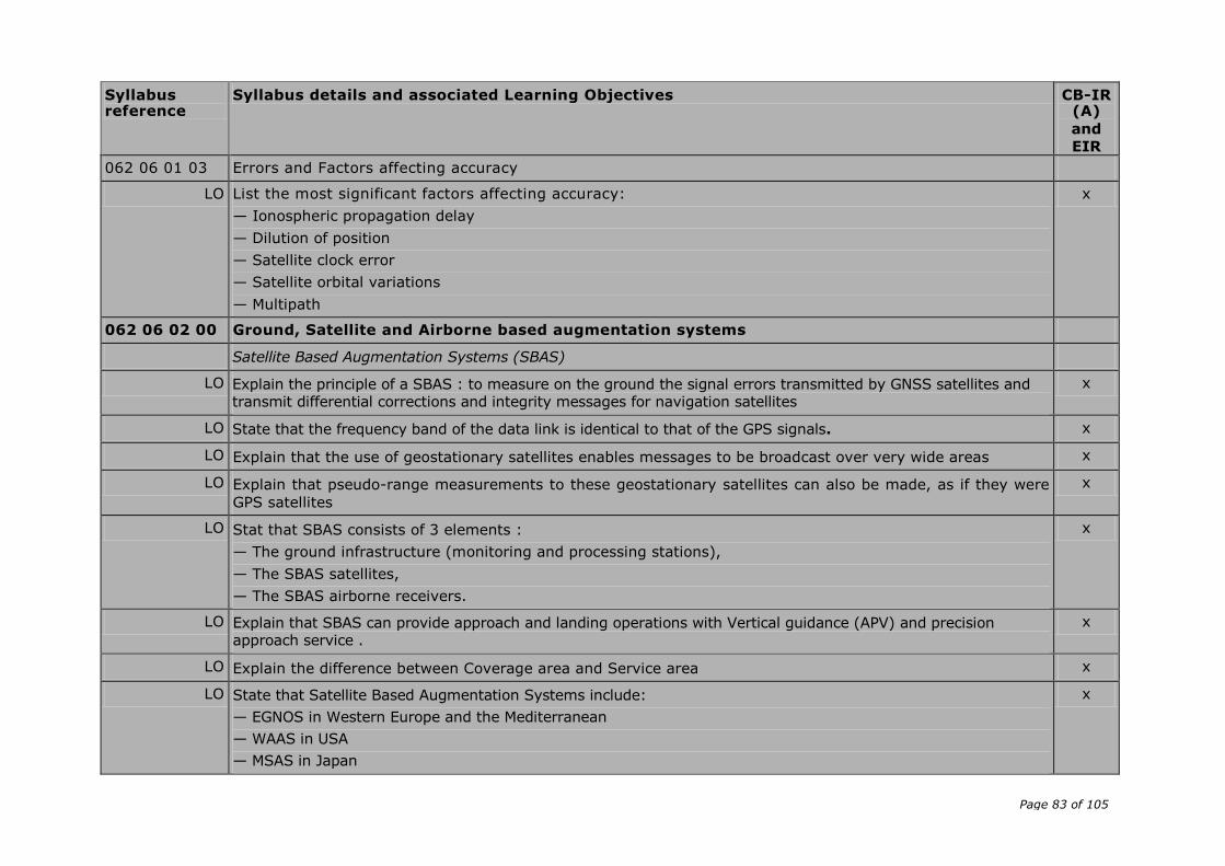
Page 83 of 105
Syllabus reference
Syllabus details and associated Learning Objectives CB-IR (A)
and
EIR
062 06 01 03 Errors and Factors affecting accuracy
LO List the most significant factors affecting accuracy:
— Ionospheric propagation delay
— Dilution of position
— Satellite clock error
— Satellite orbital variations
— Multipath
x
062 06 02 00 Ground, Satellite and Airborne based augmentation systems
Satellite Based Augmentation Systems (SBAS)
LO Explain the principle of a SBAS : to measure on the ground the signal errors transmitted by GNSS satellites and transmit differential corrections and integrity messages for navigation satellites
x
LO State that the frequency band of the data link is identical to that of the GPS signals. x
LO Explain that the use of geostationary satellites enables messages to be broadcast over very wide areas x
LO Explain that pseudo-range measurements to these geostationary satellites can also be made, as if they were
GPS satellites
x
LO Stat that SBAS consists of 3 elements :
— The ground infrastructure (monitoring and processing stations),
— The SBAS satellites,
— The SBAS airborne receivers.
x
LO Explain that SBAS can provide approach and landing operations with Vertical guidance (APV) and precision approach service .
x
LO Explain the difference between Coverage area and Service area x
LO State that Satellite Based Augmentation Systems include:
— EGNOS in Western Europe and the Mediterranean
— WAAS in USA
— MSAS in Japan
x
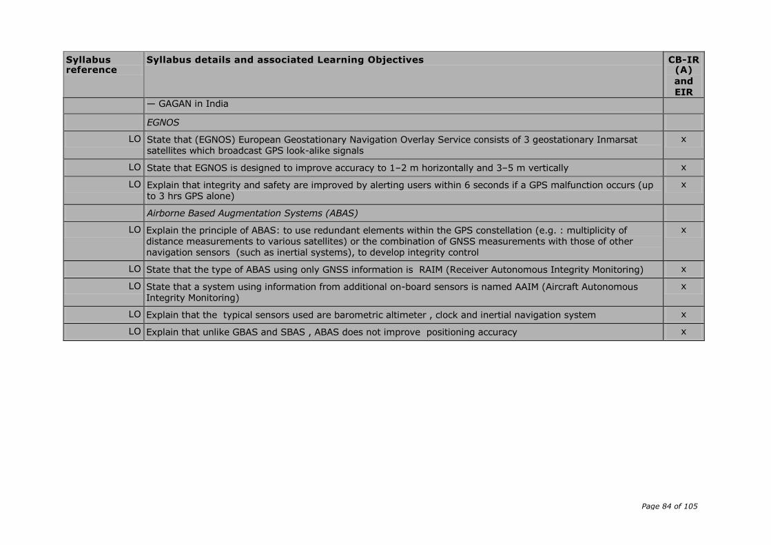
Page 84 of 105
Syllabus reference
Syllabus details and associated Learning Objectives CB-IR (A)
and
EIR
— GAGAN in India
EGNOS
LO State that (EGNOS) European Geostationary Navigation Overlay Service consists of 3 geostationary Inmarsat satellites which broadcast GPS look-alike signals
x
LO State that EGNOS is designed to improve accuracy to 1–2 m horizontally and 3–5 m vertically x
LO Explain that integrity and safety are improved by alerting users within 6 seconds if a GPS malfunction occurs (up to 3 hrs GPS alone)
x
Airborne Based Augmentation Systems (ABAS)
LO Explain the principle of ABAS: to use redundant elements within the GPS constellation (e.g. : multiplicity of distance measurements to various satellites) or the combination of GNSS measurements with those of other navigation sensors (such as inertial systems), to develop integrity control
x
LO State that the type of ABAS using only GNSS information is RAIM (Receiver Autonomous Integrity Monitoring) x
LO State that a system using information from additional on-board sensors is named AAIM (Aircraft Autonomous Integrity Monitoring)
x
LO Explain that the typical sensors used are barometric altimeter , clock and inertial navigation system x
LO Explain that unlike GBAS and SBAS , ABAS does not improve positioning accuracy x

Page 85 of 105
AMC8 FCL.615(b) IR – Theoretical knowledge and flight instruction
DETAILED THEORETICAL KNOWLEDGE SYLLABUS AND LEARNING OBJECTIVES
Subject IFR Communications (Competency-based modular training course (CB-IR(A)) for instrument rating according to Appendix 6 Aa
and en route instrument rating (EIR) course according to FCL.825)
Syllabus
reference
Syllabus details and associated Learning Objectives CB-IR(A)
and
EIR
092 00 00 00 IFR COMMUNICATIONS
092 01 00 00 DEFINITIONS
092 01 01 00 Meanings and significance of associated terms
LO As for VFR plus terms used in conjunction with approach and holding procedures x
092 01 02 00 Air Traffic Control abbreviations
LO As for VFR plus additional IFR related terms x
092 01 03 00 Q-code groups commonly used in RTF air-ground communications
LO Define Q-code groups commonly used in RTF air to ground communications:
— Pressure settings
— Directions and bearings
x
LO State the procedure for obtaining a bearing information in flight x
092 01 04 00 Categories of messages
LO List the categories of messages in order of priority x
LO Identify the types of messages appropriate to each category x
LO List the priority of a message (given examples of messages to compare) x
092 02 00 00 GENERAL OPERATING PROCEDURES
092 02 01 00 Transmission of letters
LO State the phonetic alphabet used in radiotelephony x
LO Identify the occasions when words should be spelt x
092 02 02 00 Transmission of numbers (including level information)
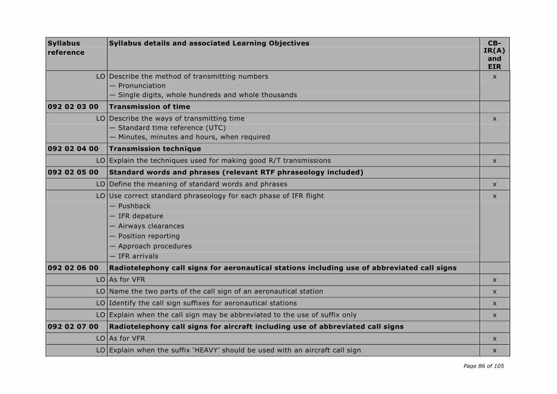
Page 86 of 105
Syllabus
reference
Syllabus details and associated Learning Objectives CB-IR(A)
and
EIR
LO Describe the method of transmitting numbers
— Pronunciation
— Single digits, whole hundreds and whole thousands
x
092 02 03 00 Transmission of time
LO Describe the ways of transmitting time
— Standard time reference (UTC)
— Minutes, minutes and hours, when required
x
092 02 04 00 Transmission technique
LO Explain the techniques used for making good R/T transmissions x
092 02 05 00 Standard words and phrases (relevant RTF phraseology included)
LO Define the meaning of standard words and phrases x
LO Use correct standard phraseology for each phase of IFR flight
— Pushback
— IFR depature
— Airways clearances
— Position reporting
— Approach procedures
— IFR arrivals
x
092 02 06 00 Radiotelephony call signs for aeronautical stations including use of abbreviated call signs
LO As for VFR x
LO Name the two parts of the call sign of an aeronautical station x
LO Identify the call sign suffixes for aeronautical stations x
LO Explain when the call sign may be abbreviated to the use of suffix only x
092 02 07 00 Radiotelephony call signs for aircraft including use of abbreviated call signs
LO As for VFR x
LO Explain when the suffix ‘HEAVY’ should be used with an aircraft call sign x
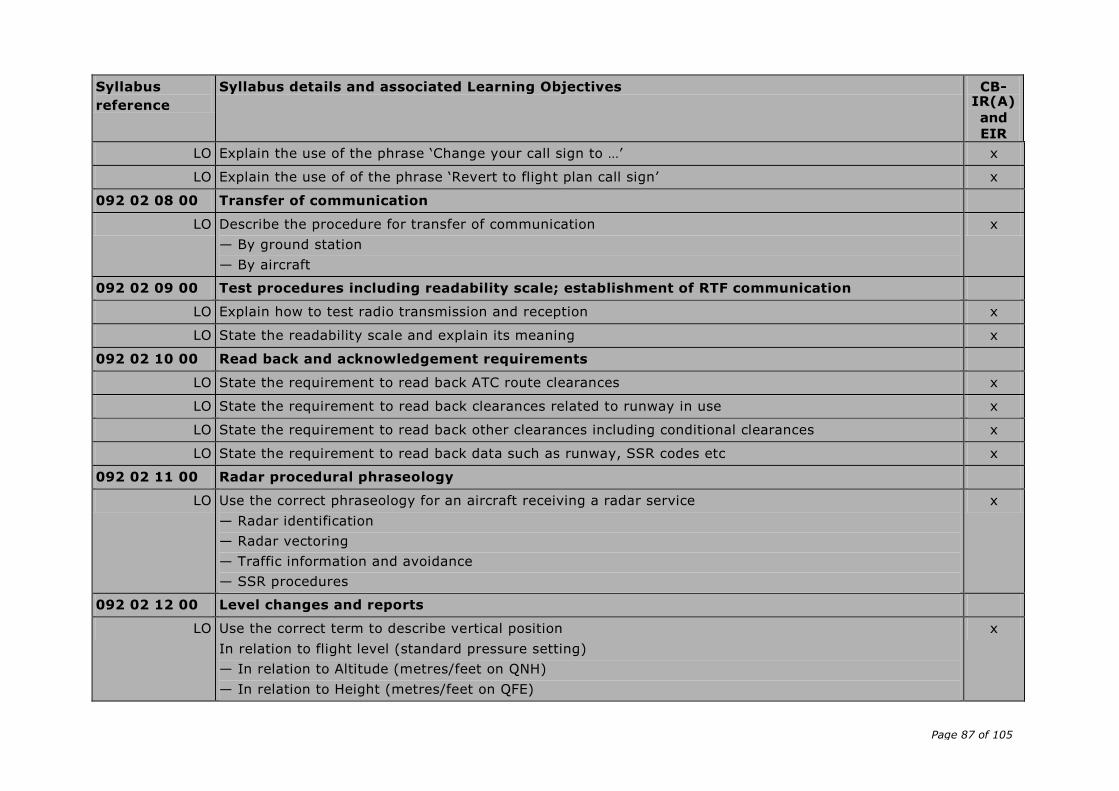
Page 87 of 105
Syllabus
reference
Syllabus details and associated Learning Objectives CB-IR(A)
and
EIR
LO Explain the use of the phrase ‘Change your call sign to …’ x
LO Explain the use of of the phrase ‘Revert to flight plan call sign’ x
092 02 08 00 Transfer of communication
LO Describe the procedure for transfer of communication
— By ground station
— By aircraft
x
092 02 09 00 Test procedures including readability scale; establishment of RTF communication
LO Explain how to test radio transmission and reception x
LO State the readability scale and explain its meaning x
092 02 10 00 Read back and acknowledgement requirements
LO State the requirement to read back ATC route clearances x
LO State the requirement to read back clearances related to runway in use x
LO State the requirement to read back other clearances including conditional clearances x
LO State the requirement to read back data such as runway, SSR codes etc x
092 02 11 00 Radar procedural phraseology
LO Use the correct phraseology for an aircraft receiving a radar service
— Radar identification
— Radar vectoring
— Traffic information and avoidance
— SSR procedures
x
092 02 12 00 Level changes and reports
LO Use the correct term to describe vertical position
In relation to flight level (standard pressure setting)
— In relation to Altitude (metres/feet on QNH)
— In relation to Height (metres/feet on QFE)
x

Page 88 of 105
Syllabus
reference
Syllabus details and associated Learning Objectives CB-IR(A)
and
EIR
092 03 00 00 ACTION REQUIRED TO BE TAKEN IN CASE OF COMMUNICATION FAILURE
LO Describe the action to be taken in communication failure on a IFR flight x
LO Describe the action to be taken in case of communication failure on a IFR flight when flying in VMC and the flight will be terminated in VMC
x
LO Describe the action to be taken in case of communication failure on a IFR flight when flying in IMC x
092 04 00 00 DISTRESS AND URGENCY PROCEDURES
092 04 01 00 PAN medical
LO Describe the type of flights to which PAN MEDICAL applies x
LO List the content of a PAN MEDICAL message in correct sequence x
092 04 02 00 Distress (definition — frequencies — watch of distress frequencies — distress signal — distress message)
LO State the DISTRESS procedures x
LO Define DISTRESS x
LO Identify the frequencies that should be used by aircraft in DISTRESS x
LO Specify the emergency SSR codes that may be used by aircraft, and the meaning of the codes x
LO Describe the action to be taken by the station which receives a DISTRESS message x
LO Describe the action to be taken by all other stations when a DISTRESS procedure is in progress x
LO List the content of a DISTRESS message x
092 04 03 00 Urgency (definition — frequencies — urgency signal — urgency message)
LO State the URGENCY procedures x
LO Define URGENCY x
LO Identify the frequencies that should be used by aircraft in URGENCY x
LO Describe the action to be taken by the station which receives an URGENCY message x
LO List the content of an URGENCY signal/message in the correct sequence x
092 05 00 00 RELEVANT WEATHER INFORMATION TERMS (IFR)
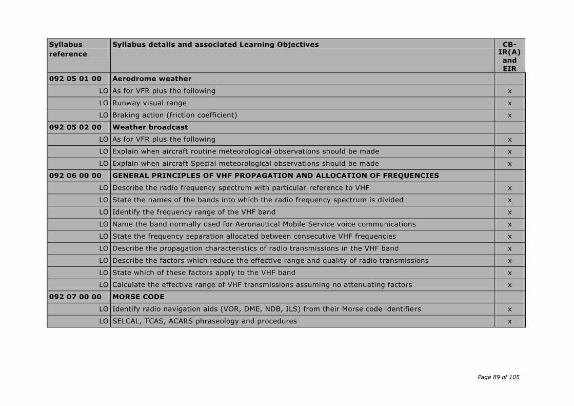
Page 89 of 105
Syllabus
reference
Syllabus details and associated Learning Objectives CB-IR(A)
and
EIR
092 05 01 00 Aerodrome weather
LO As for VFR plus the following x
LO Runway visual range x
LO Braking action (friction coefficient) x
092 05 02 00 Weather broadcast
LO As for VFR plus the following x
LO Explain when aircraft routine meteorological observations should be made x
LO Explain when aircraft Special meteorological observations should be made x
092 06 00 00 GENERAL PRINCIPLES OF VHF PROPAGATION AND ALLOCATION OF FREQUENCIES
LO Describe the radio frequency spectrum with particular reference to VHF x
LO State the names of the bands into which the radio frequency spectrum is divided x
LO Identify the frequency range of the VHF band x
LO Name the band normally used for Aeronautical Mobile Service voice communications x
LO State the frequency separation allocated between consecutive VHF frequencies x
LO Describe the propagation characteristics of radio transmissions in the VHF band x
LO Describe the factors which reduce the effective range and quality of radio transmissions x
LO State which of these factors apply to the VHF band x
LO Calculate the effective range of VHF transmissions assuming no attenuating factors x
092 07 00 00 MORSE CODE
LO Identify radio navigation aids (VOR, DME, NDB, ILS) from their Morse code identifiers x
LO SELCAL, TCAS, ACARS phraseology and procedures x
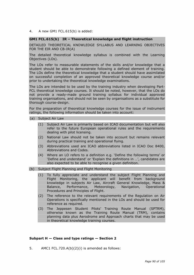
Page 90 of 105
4. A new GM1 FCL.615(b) is added:
GM1 FCL.615(b) IR – Theoretical knowledge and flight instruction
DETAILED THEORETICAL KNOWLEDGE SYLLABUS AND LEARNING OBJECTIVES
FOR THE EIR AND CB-IR(A)
The detailed theoretical knowledge syllabus is combined with the Learning
Objectives (LOs).
The LOs refer to measurable statements of the skills and/or knowledge that a
student should be able to demonstrate following a defined element of training.
The LOs define the theoretical knowledge that a student should have assimilated
on successful completion of an approved theoretical knowledge course and/or
prior to undertaking the theoretical knowledge examinations.
The LOs are intended to be used by the training industry when developing Part-
FCL theoretical knowledge courses. It should be noted, however, that the LOs do
not provide a ready-made ground training syllabus for individual approved
training organisations, and should not be seen by organisations as a substitute for
thorough course-design.
For the preparation of theoretical knowledge courses for the issue of instrument
ratings, the following information should be taken into account:
(a) Subject Air Law
(1) Subject Air Law is primarily based on ICAO documentation but will also
refer to the future European operational rules and the requirements
dealing with pilot licensing.
(2) National Law should not be taken into account but remains relevant
during practical training and operational flying.
(3) Abbreviations used are ICAO abbreviations listed in ICAO Doc 8400,
Abbreviations and Codes.
(4) Where an LO refers to a definition e.g. ‘Define the following terms’ or
‘Define and understand’ or ‘Explain the definitions in …’, candidates are
also expected to be able to recognise a given definition.
(b) Subject Flight Planning and Flight Monitoring
(1) To fully appreciate and understand the subject Flight Planning and
Flight Monitoring, the applicant will benefit from background
knowledge in subjects Air Law, Aircraft General Knowledge, Mass &
Balance, Performance, Meteorology, Navigation, Operational
Procedures and Principles of Flight.
(2) The reference to the relevant requirements of the Regulation on Air
Operations is specifically mentioned in the LOs and should be used for
reference as required.
(3) The Jeppesen Student Pilots’ Training Route Manual (SPTRM),
otherwise known as the Training Route Manual (TRM), contains
planning data plus Aerodrome and Approach charts that may be used
in theoretical knowledge training courses.
Subpart H — Class and type ratings — Section 2
5. AMC1 FCL.720.A(b)(2)(i) is amended as follows:

Page 91 of 105
‘AMC1 FCL.720.A(b)(2)(i) Experience requirements and prerequisites
for the issue of class or type ratings — aeroplanes
ADDITIONAL THEORETICAL KNOWLEDGE FOR A CLASS OR TYPE RATING FOR HIGH PERFORMANCE SP AEROPLANES
[…]
COURSE SYLLABUS
(c) The course will be divided in a VFR and an IFR part, and should cover at
least the following items of the aeroplane syllabus to the ATPL(A) level:
FOR VFR OPERATION:
LO number
Subject Ref.: LO topicsSyllabus Content:
[...] [...]
FOR IFR OPERATION:
Subject Ref.: Syllabus Content
010 00 00 00 AIR LAW
010 06 07 00 Simultaneous Operation on parallel or near-parallel instrument
Runways
010 06 08 00 Secondary surveillance radar (transponder) operating
procedures
010 09 08 02 Radio altimeter operating areas
022 00 00 00 AIRCRAFT GENERAL KNOWLEDGE - INSTRUMENTATION
022 02 02 02 Temperature measurement - Design and operation
022 03 04 00 Flux valve
022 12 00 00 ALERTING SYSTEMS, PROXIMITY SYSTEMS
022 12 07 00 Altitude alert system
022 12 08 00 Radio-altimeter
022 12 10 00 ACAS/TCAS principles and operation
022 13 03 01 Electronic Flight Instrument System (EFIS) — Design, operation
050 00 00 00 METEOROLOGY
050 02 06 03 Clear Air turbulence (CAT) - Description, cause and location
050 10 02 03 Upper air charts
062 00 00 00 RADIO NAVIGATION
062 02 05 04 ILS — Errors and accuracy
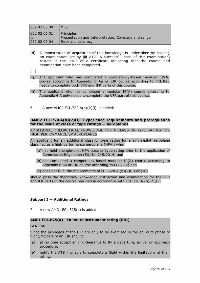
Page 92 of 105
062 02 06 00 MLS
062 02 06 01
to
062 02 06 04
Principles
Presentation and Interpretation, Coverage and range
Error and accuracy
(d) Demonstration of acquisition of this knowledge is undertaken by passing
an examination set by an ATO. A successful pass of this examination, results in the issue of a certificate indicating that the course and examination have been completed.
[…]
(g) The applicant who has completed a competency-based modular IR(A)
course according to Appendix 6 Aa or EIR course according to FCL.825
needs to complete both VFR and IFR parts of this course.
(h) The applicant who has completed a modular IR(A) course according to
Appendix 6 A only needs to complete the VFR part of this course.
6. A new AMC2 FCL.720.A(b)(2)(i) is added:
‘AMC2 FCL.720.A(b)(2)(i) Experience requirements and prerequisites
for the issue of class or type ratings — aeroplanes
ADDITIONAL THEORETICAL KNOWLEDGE FOR A CLASS OR TYPE RATING FOR HIGH PERFORMANCE SP AEROPLANES
An applicant for an additional class or type rating for a single-pilot aeroplane
classified as a high performance aeroplane (HPA), who:
(a) has held a single-pilot HPA class or type rating prior to the application of
Commission Regulation (EU) No 245/2014; and
(b) has completed a competency-based modular IR(A) course according to
Appendix 6 Aa or EIR course according to FCL.825; and
(c) does not fulfil the requirements of FCL.720.A (b)(2)(ii) or (iii);
should pass the theoretical knowledge instruction and examination for the VFR
and IFR parts of the course required in accordance with FCL.720.A.(b)(2)(i).’
Subpart I — Additional Ratings
7. A new AMC1 FCL.825(a) is added:
AMC1 FCL.825(a) En Route instrument rating (EIR)
GENERAL
Since the privileges of the EIR are only to be exercised in the en route phase of
flight, holders of an EIR should:
(a) at no time accept an IFR clearance to fly a departure, arrival or approach
procedure;
(b) notify the ATS if unable to complete a flight within the limitations of their
rating.

Page 93 of 105
CONDITIONS FOR THE EXERCISE OF THE PRIVILEGES OF AN EN ROUTE
INSTRUMENT RATING (EIR)
(c) To comply with FCL.825(a)(2), the holder of an EIR should not commence
or continue a flight during which it is intended to exercise the privileges of
the rating unless the appropriate weather reports or forecasts for the
destination and alternate aerodrome for the period from one hour before
until one hour after the planned time of arrival indicates VMC. The flight
may be planned only to aerodromes for which such meteorological
information is available. When filing a flight plan, the holder of an EIR
should include suitable VFR to IFR and IFR to VFR transitions. In any case,
the pilot needs to apply the relevant operational rules, which ever are more
limiting.
(d) A suitable VFR to IFR transition is any navigational fix
(1) to which the flight can be safely conducted under VFR; and
(2) which is acceptable to ATS if available.
(e) A suitable IFR to VFR transition is any navigational fix
(1) to which the flight can be safely conducted under IFR;
(2) at which VMC conditions exist; and
(3) from where the flight can be safely continued under VFR without
having to follow instrument arrival or approach procedures.
8. A new AMC1 FCL.825(c) is added:
AMC1 FCL.825(c) En route instrument rating (EIR)
FLYING TRAINING
The flight instruction for the EIR should comprise the following flying exercises:
(a) pre-flight procedures for IFR flights, including the use of the flight manual,
meteorological information, appropriate air traffic service documents, filing
of an IFR flight plan, including VFR/IFR transitions and diversions;
(b) use of appropriate IFR and VFR charts;
(c) basic instrument flight by sole reference to instruments:
— horizontal flight,
— climbing,
— descending,
— turns in level flight, climbing, descending;
(d) steep turns and recovery from unusual attitudes on full and limited panel;
(e) normal flight on limited panel;
(f) instrument pattern;
(g) procedures and manoeuvres for IFR operation under normal, abnormal and
emergency conditions covering at least:
— transition from visual to instrument flight after departure,
Page 94 of 105
— en route IFR procedures,
— en route holding procedures,
— transition from instrument flight en route to visual before reaching the
Minimum Sector Altitude (MSA);
(h) radio navigation (GPS/VOR);
(i) use of advanced equipment such as autopilot, flight director, stormscope,
de-icing equipment, EFIS or radar, as available;
(j) emergency procedures covering the deterioration of meteorological
conditions;
(k) at least two IFR approaches in the context of an emergency situation;
(l) use of RT techniques in order to gain a competence to a high standard;
(m) if required, operation of a multi-engine aeroplane during the above range of
exercises to include engine failures and cruise flight with one engine
simulated inoperative;
(n) the flight instruction should also include at least two flights in controlled
airspace under IFR with a high density of traffic and VFR arrivals and
departures from aerodromes with a mixture of instrument and visual traffic.
9. A new AMC1 FCL.825(d) is added:
AMC1 FCL.825(d) En route instrument rating (EIR)
SYLLABUS OF THEORETICAL KNOWLEDGE FOR THE EIR
For the theoretical knowledge syllabus for the EIR, refer to AMC1 FCL.615(b).
10. A new AMC2 FCL.825(d) is added:
AMC2 FCL.825(d) En route instrument rating (EIR)
THEORETICAL KNOWLEDGE INSTRUCTION AND EXAMINATION
(a) GENERAL
The theoretical knowledge instruction and examination is the same as for
the instrument rating following the competency-based modular course
according to Appendix 6 Aa.
(b) THEORETICAL KNOWLEDGE
The applicant should complete an approved competency-based IR(A) or EIR
theoretical knowledge (TK) course. The approved CB-IR(A) or EIR TK course
may contain computer-based training, e-learning elements, interactive
video, slide/tape presentation, learning carrels and other media as approved
by the authority, in suitable proportions. Approved distance learning
(correspondence) courses may also be offered as part of the course. The
minimum amount of classroom teaching, as required by ORA.ATO.305, has
to be provided.
(c) THEORETICAL KNOWLEDGE EXAMINATION
Page 95 of 105
The number of questions per subject, the distribution of questions and the
time allocated to each subject is detailed in AMC2 ARA.FCL.300(b).
11. A new AMC3 FCL.825(d) is added:
AMC3 FCL.825(d) En route instrument rating (EIR)
DETAILED THEORETICAL KNOWLEDGE SYLLABUS AND LEARNING OBJECTIVES FOR EIR
For the detailed theoretical knowledge syllabus and learning objectives, refer to
AMC2 FCL.615(b) through to AMC8 FCL.615(b).
12. A new GM1 FCL.825(d) is added:
GM1 FCL.825(d) En route instrument rating (EIR)
DETAILED THEORETICAL KNOWLEDGE SYLLABUS AND LEARNING OBJECTIVES
FOR EIR
For the detailed theoretical knowledge syllabus and learning objectives, refer to
GM1 FCL.615(b).
13. A new AMC1 FCL.825(e); (g) is added:
AMC1 FCL.825(e); (g) En route instrument rating (EIR)
SKILL TEST/PROFICIENCY CHECK FOR THE ISSUE, REVALIDATION, OR RENEWAL
OF AN EN ROUTE INSTRUMENT RATING (EIR)
(a) An applicant for an EIR should have received instrument flight instruction on the same type or class of aeroplane to be used in the test/check.
(b) An applicant should pass all the relevant sections of the skill test/proficiency check. If any item in a section is failed, that section is failed. Failure in more than one section will require the applicant to take the entire test/check again. An applicant failing only one section should only repeat the failed section. Failure in any section of the retest/recheck, including those sections that have been passed on a previous attempt, requires the applicant to take the entire test/check again. All sections of the skill test/proficiency check should be completed within six months. Failure to achieve a pass in all sections of the test/check in two attempts requires further training.
(c) Further training may be required following a failed skill test/proficiency check. There is no limit to the number of skill tests/proficiency checks that may be attempted.
CONDUCT OF THE TEST/CHECK
(d) The test/check is intended to simulate a practical flight. The route to be
flown shall be chosen by the examiner. An essential element is the
ability of the applicant to plan and conduct the flight from routine

Page 96 of 105
briefing material. The applicant should undertake the flight planning and
should ensure that all equipment and documentation for the execution of
the flight are on board. The duration of the flight should be at least 60
minutes.
(e) Should the applicant choose to terminate a skill test/proficiency check for reasons considered inadequate by the flight examiner, the applicant should retake the entire skill test/proficiency check. If the test/check is terminated for reasons considered adequate by the examiner, only those sections not completed should be tested in a further flight.
(f) At the discretion of the examiner any manoeuvre or procedure of the test/check may be repeated once by the applicant. The examiner may stop the test/check at any stage if it is considered that the applicant’s demonstration of flying skill requires a complete retest/recheck.
(g) An applicant should fly the aeroplane from a position where the pilot-in-
command functions can be performed and to carry out the test/check as
if there is no other crew member. Responsibility for the flight should be
allocated in accordance with national regulations.
(h) Minimum descent heights/altitudes and the transition points should be
determined by the applicant and agreed by the examiner.
(i) An applicant for an EIR should indicate to the examiner the checks and
duties carried out, including the identification of radio facilities. The
checks should be completed in accordance with the authorised checklist
for the aeroplane on which the test/check is being taken. During pre-
flight preparation for the test/check the applicant should determine
power settings and speeds. Performance data for take-off, approach and
landing should be calculated by the applicant in compliance with the
operations manual or flight manual for the aeroplane used.
FLIGHT TEST TOLERANCES
(j) The applicant should demonstrate the ability to:
– operate the aeroplane within its limitations;
– complete all manoeuvres with smoothness and accuracy;
– exercise good judgment and airmanship;
– apply aeronautical knowledge; and
– maintain control of the aeroplane at all times in such a manner that the successful outcome of a procedure or manoeuvre is never seriously in doubt.
(k) The following limits should apply, corrected to make allowance for
turbulent conditions, and the handling qualities and performance of the
aeroplane used
Height
Generally ±100 feet
Tracking
on radio aids ±10°
Heading
all engines operating ±10°
with simulated engine failure ±15°
Speed
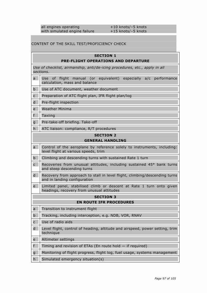
Page 97 of 105
all engines operating +10 knots/–5 knots
with simulated engine failure +15 knots/–5 knots
CONTENT OF THE SKILL TEST/PROFICIENCY CHECK
SECTION 1
PRE-FLIGHT OPERATIONS AND DEPARTURE
Use of checklist, airmanship, anti/de-icing procedures, etc., apply in all
sections.
a Use of flight manual (or equivalent) especially a/c performance
calculation, mass and balance
b Use of ATC document, weather document
c Preparation of ATC flight plan, IFR flight plan/log
d Pre-flight inspection
e Weather Minima
f Taxiing
g Pre-take-off briefing. Take-off
h ATC liaison: compliance, R/T procedures
SECTION 2
GENERAL HANDLING
a Control of the aeroplane by reference solely to instruments, including:
level flight at various speeds, trim
b Climbing and descending turns with sustained Rate 1 turn
c Recoveries from unusual attitudes, including sustained 45° bank turns
and steep descending turns
d Recovery from approach to stall in level flight, climbing/descending turns
and in landing configuration
e Limited panel, stabilised climb or descent at Rate 1 turn onto given
headings, recovery from unusual attitudes
SECTION 3
EN ROUTE IFR PROCEDURES
a Transition to instrument flight
b Tracking, including interception, e.g. NDB, VOR, RNAV
c Use of radio aids
d Level flight, control of heading, altitude and airspeed, power setting, trim
technique
e Altimeter settings
f Timing and revision of ETAs (En route hold — if required)
g Monitoring of flight progress, flight log, fuel usage, systems management
h Simulated emergency situation(s)

Page 98 of 105
i Ice protection procedures, simulated if necessary
j Simulated diversion to alternate aerodrome
k Transition to visual flight
l ATC liaison and compliance, R/T procedures
SECTION 4
Intentionally left blank
SECTION 5
a Setting and checking of navigational aids, identification of facilities
b Arrival procedures, altimeter settings
c Approach and landing briefing, including descent/approach/landing
checks
d Visual landing
e ATC liaison: compliance, R/T procedures
SECTION 6 (multi-engine aeroplanes only)
Flight with one engine inoperative
a Simulated engine failure during en route phase of flight
b ATC liaison: compliance, R/T procedures
14. A new AMC1 FCL.825(g)(2) is added:
AMC1 FCL.825(g)(2)) En route instrument rating (EIR)
TRAINING FLIGHT FOR REVALIDATION
(a) The training flight for the revalidation of an EIR should be based on the
exercise items of the EIR proficiency check as deemed relevant by the
instructor and should depend on the experience of the candidate. The
training flight should include a briefing including a discussion on threat and
error management with a special emphasis on decision making when
encountering adverse meteorological conditions, unintentional Instrument
Meteorological Conditions (IMC) and navigation flight capabilities.
(b) In any case, a simulated diversion and instrument approach to an alternate
aerodrome in the context of an emergency situation during the en route
phase in IFR should be demonstrated by the instructor.
15. A new AMC1 FCL.825(h) is added:
AMC1 FCL.825(h) En route instrument rating (EIR)
PRE-ENTRY ASSESSMENT AND TRAINING RECORD
(a) PRE-ENTRY ASSESSMENT
Page 99 of 105
The assessment to establish the amount of training to be credited and to
identify the training needs should be based on the EIR training syllabus
established in AMC1 FCL.825(c).
(b) TRAINING RECORD
(1) Before initiating the assessment, the applicant should provide the ATO
with a training record containing the details of the previous flight
training provided by the IRI(A) or the FI(A). This training record should
at least specify the aircraft type and registration used for the training,
the number of flights and the total amount of instrument flight time
under instruction. It should also specify all the exercises completed
during the training by using the syllabus contained in AMC1 FCL.825(c).
(2) The instructor(s) having provided the training should keep the training
records containing all the details of the flight training given for a period
of at least 5 years after the completion of the training.
16. A new AMC2 FCL.825(h) is added:
AMC2 FCL.825(h) En route instrument rating (EIR)
TRAINING AIRCRAFT
The aeroplane used for the instrument flight time under instruction provided
outside an ATO by an IRI(A) or FI(A) should be:
(a) fitted with primary flight controls that are instantly accessible by both
the student and the instructor (for example dual flight controls or a
centre control stick). Swing-over flight controls should not be used; and
(b) suitably equipped to simulate instrument meteorological conditions
(IMC) and for the instrument flight training required.
17. A new AMC1 FCL.825(i) is added:
AMC1 FCL.825(i) En route instrument rating (EIR)
CREDITING ON THE BASIS OF A THIRD COUNTRY IR(A) RATING
In order to be credited in full towards the multi-engine EIR training course
requirements, the applicant should:
(a) hold a multi-engine IR(A), issued in accordance with the requirements of
Annex 1 to the Chicago Convention by a third country;
(b) have the minimum experience required in FCL.825 paragraph (i)(3), of
which at least 4 hours should be completed in a multi-engine aeroplane.
18. A new AMC1 FCL.830 is added:
Page 100 of 105
AMC1 FCL.830 Sailplane Cloud Flying Rating
THEORETICAL KNOWLEDGE INSTRUCTION AND FLIGHT INSTRUCTION
1. THEORETICAL KNOWLEDGE INSTRUCTION
The theoretical knowledge syllabus should cover the revision and/or explanation
of:
1.1. Human Factors and Body Limitations
— basic aviation physiology in regards cloud flying aspects
— basic aviation psychology
— spatial disorientation
1.2. Principles of Flight
— stability
— control
— limitations (load factor and manoeuvres)
1.3. Aircraft Instrumentation
— sensors and instruments
— measurement of air data parameters
— gyroscopic instruments
1.4. Navigation
— use of GPS
— use of charts
— dead reckoning navigation (DR)
— air traffic regulations — airspace structure
— aeronautical information service
— Member State regulations regarding cloud flying
1.5. Communications
— VHF communications
— relevant weather information terms
1.6. Hazards and Emergency Procedures
— icing
— cloud escape procedures
— anti-collision instruments/avionics
2. FLYING TRAINING
2.1. The exercises of the sailplane cloud flight instruction syllabus should be
repeated as necessary until the student achieves a safe and competent
standard and should comprise at least the following practical training
items, flown solely by reference to instruments:
— straight flight
— turning
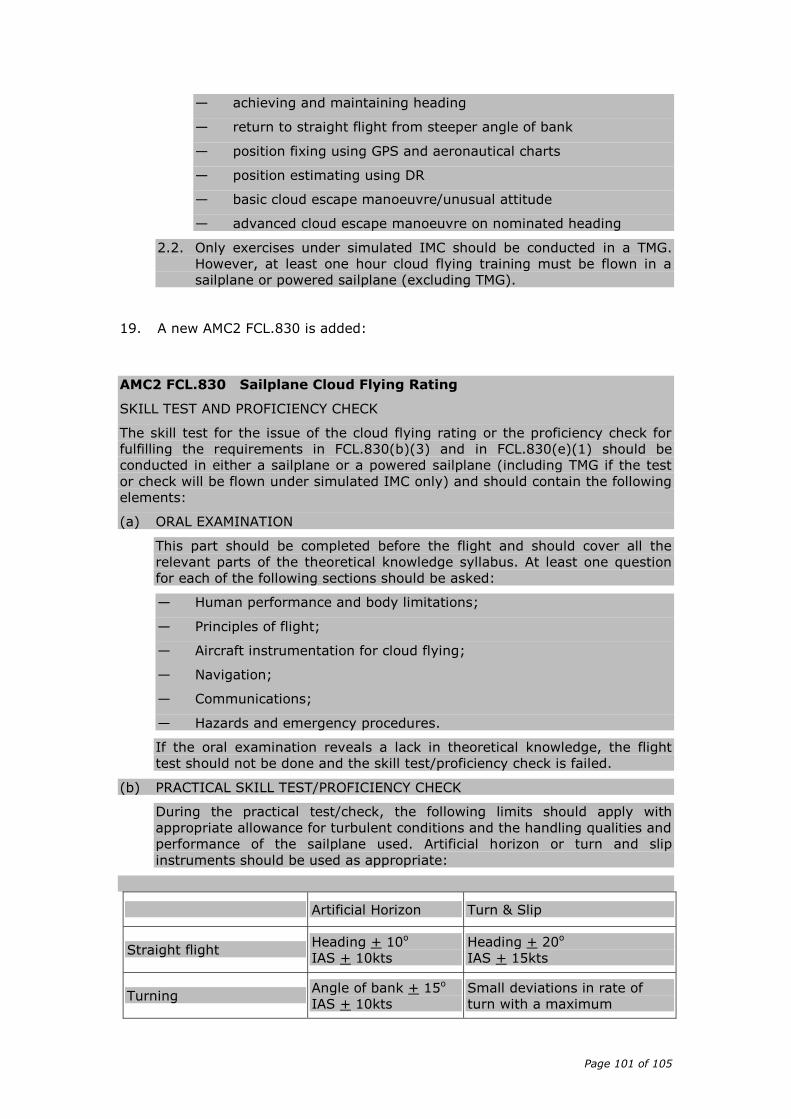
Page 101 of 105
— achieving and maintaining heading
— return to straight flight from steeper angle of bank
— position fixing using GPS and aeronautical charts
— position estimating using DR
— basic cloud escape manoeuvre/unusual attitude
— advanced cloud escape manoeuvre on nominated heading
2.2. Only exercises under simulated IMC should be conducted in a TMG.
However, at least one hour cloud flying training must be flown in a
sailplane or powered sailplane (excluding TMG).
19. A new AMC2 FCL.830 is added:
AMC2 FCL.830 Sailplane Cloud Flying Rating
SKILL TEST AND PROFICIENCY CHECK
The skill test for the issue of the cloud flying rating or the proficiency check for
fulfilling the requirements in FCL.830(b)(3) and in FCL.830(e)(1) should be
conducted in either a sailplane or a powered sailplane (including TMG if the test
or check will be flown under simulated IMC only) and should contain the following
elements:
(a) ORAL EXAMINATION
This part should be completed before the flight and should cover all the
relevant parts of the theoretical knowledge syllabus. At least one question
for each of the following sections should be asked:
— Human performance and body limitations;
— Principles of flight;
— Aircraft instrumentation for cloud flying;
— Navigation;
— Communications;
— Hazards and emergency procedures.
If the oral examination reveals a lack in theoretical knowledge, the flight
test should not be done and the skill test/proficiency check is failed.
(b) PRACTICAL SKILL TEST/PROFICIENCY CHECK
During the practical test/check, the following limits should apply with
appropriate allowance for turbulent conditions and the handling qualities and
performance of the sailplane used. Artificial horizon or turn and slip
instruments should be used as appropriate:
Artificial Horizon Turn & Slip
Straight flight Heading + 10o
IAS + 10kts
Heading + 20o
IAS + 15kts
Turning Angle of bank + 15o
IAS + 10kts
Small deviations in rate of
turn with a maximum
Page 102 of 105
deviation between ½ & full
scale
IAS + 15ts
Position fixing given:
GPS displaying range and
bearing to a point
+ 2NM
+ 3NM
During the practical test/check, the following exercises should be
successfully completed by the applicant, flown solely by reference to
instruments and taking into account the limits above:
— straight flight;
— turning;
— achieving and maintaining heading;
— return to straight flight from steeper angle of bank;
— position fixing using GPS and aeronautical charts;
— position estimating using DR;
— basic cloud escape manoeuvre/unusual attitude;
— advanced cloud escape manoeuvre on nominated heading.
Appendix 6 Modular training courses for the IR
20. Amend AMC1 to Appendix 6 as follows:
AMC1 to Appendix 6 Modular training courses for the IR
ALL MODULAR FLYING TRAINING COURSES FOR THE IR, EXCEPT COMPETENCY-
BASED MODULAR FLYING TRAINING COURSE
[…]
21. Amend AMC2 to Appendix 6 as follows:
AMC2 to Appendix 6 Modular training courses for the IR
AEROPLANES
SECTION A IR(A) - MODULAR FLYING TRAINING COURSE
[…]
22. A new AMC3 to Appendix 6 is added:
AMC3 to Appendix 6 Modular training courses for the IR
SECTION Aa IR(A) – COMPETENCY-BASED MODULAR FLYING TRAINING COURSE
(a) THEORETICAL KNOWLEDGE INSTRUCTION

Page 103 of 105
(1) The theoretical knowledge instruction may be given at an approved
training organisation conducting theoretical knowledge instruction only,
in which case the Head of Training of that organisation should
supervise that part of the course.
(2) The required theoretical knowledge instruction for the IR following the
competency-based route may contain computer-based training, e-
learning elements, interactive video, slide/tape presentation, learning
carrels and other media as approved by the authority, in suitable
proportions. Approved distance learning (correspondence) courses may
also be offered as part of the course. The minimum amount of
classroom teaching has to be provided as required by ORA.ATO.305.
(b) THEORETICAL KNOWLEDGE EXAMINATION
The applicant for the IR following the competency-based training route should
pass an examination to demonstrate a level of theoretical knowledge appropriate
to the privileges granted in the subjects further detailed in FCL.615(b). The
number of questions per subject, the distribution of questions and the time
allocated to each subject is detailed in AMC2 ARA.FCL.300(b).
23. A new AMC4 to Appendix 6 is added:
AMC4 to Appendix 6 Modular training courses for the IR
SECTION Aa IR(A) – COMPETENCY-BASED MODULAR FLYING TRAINING COURSE
FLYING TRAINING
(a) The instrument flight instruction outside an ATO provided by an IRI(A) or an
FI(A) holding the privilege to provide training for the IR in accordance with
Appendix 6 Section Aa (6)(a)(i)(A) may consist of instrument flight time
under instruction or instrument ground time or a combination thereof.
TRAINING AIRCRAFT
(b) The aeroplane used for the instrument flight training provided outside an
ATO by an IRI(A) or FI(A) should be:
(1) fitted with primary flight controls that are instantly accessible by both
the student and the instructor (for example dual flight controls or a
centre control stick). Swing-over flight controls should not be used; and
(2) suitably equipped to simulate instrument meteorological conditions
(IMC) and for the instrument flight training required.
(c) The FSTD used for the instrument flight instruction provided outside an ATO
by an IRI(A) or FI(A) should be suitably equipped to simulate instrument
meteorological conditions (IMC) and for the instrument flight training
required
24. A new AMC5 to Appendix 6 is added:
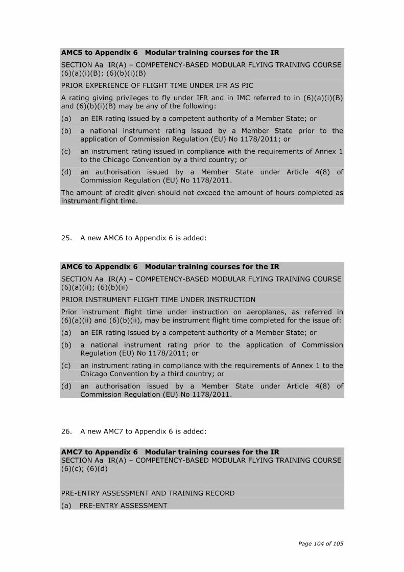
Page 104 of 105
AMC5 to Appendix 6 Modular training courses for the IR
SECTION Aa IR(A) – COMPETENCY-BASED MODULAR FLYING TRAINING COURSE
(6)(a)(i)(B); (6)(b)(i)(B)
PRIOR EXPERIENCE OF FLIGHT TIME UNDER IFR AS PIC
A rating giving privileges to fly under IFR and in IMC referred to in (6)(a)(i)(B)
and (6)(b)(i)(B) may be any of the following:
(a) an EIR rating issued by a competent authority of a Member State; or
(b) a national instrument rating issued by a Member State prior to the
application of Commission Regulation (EU) No 1178/2011; or
(c) an instrument rating issued in compliance with the requirements of Annex 1
to the Chicago Convention by a third country; or
(d) an authorisation issued by a Member State under Article 4(8) of
Commission Regulation (EU) No 1178/2011.
The amount of credit given should not exceed the amount of hours completed as
instrument flight time.
25. A new AMC6 to Appendix 6 is added:
AMC6 to Appendix 6 Modular training courses for the IR
SECTION Aa IR(A) – COMPETENCY-BASED MODULAR FLYING TRAINING COURSE
(6)(a)(ii); (6)(b)(ii)
PRIOR INSTRUMENT FLIGHT TIME UNDER INSTRUCTION
Prior instrument flight time under instruction on aeroplanes, as referred in
(6)(a)(ii) and (6)(b)(ii), may be instrument flight time completed for the issue of:
(a) an EIR rating issued by a competent authority of a Member State; or
(b) a national instrument rating prior to the application of Commission
Regulation (EU) No 1178/2011; or
(c) an instrument rating in compliance with the requirements of Annex 1 to the
Chicago Convention by a third country; or
(d) an authorisation issued by a Member State under Article 4(8) of
Commission Regulation (EU) No 1178/2011.
26. A new AMC7 to Appendix 6 is added:
AMC7 to Appendix 6 Modular training courses for the IR
SECTION Aa IR(A) – COMPETENCY-BASED MODULAR FLYING TRAINING COURSE
(6)(c); (6)(d)
PRE-ENTRY ASSESSMENT AND TRAINING RECORD
(a) PRE-ENTRY ASSESSMENT
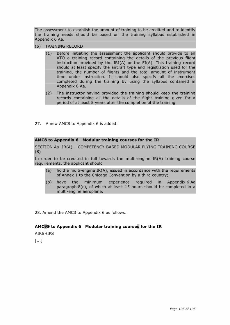
Page 105 of 105
The assessment to establish the amount of training to be credited and to identify
the training needs should be based on the training syllabus established in
Appendix 6 Aa.
(b) TRAINING RECORD
(1) Before initiating the assessment the applicant should provide to an
ATO a training record containing the details of the previous flight
instruction provided by the IRI(A) or the FI(A). This training record
should at least specify the aircraft type and registration used for the
training, the number of flights and the total amount of instrument
time under instruction. It should also specify all the exercises
completed during the training by using the syllabus contained in
Appendix 6 Aa.
(2) The instructor having provided the training should keep the training
records containing all the details of the flight training given for a
period of at least 5 years after the completion of the training.
27. A new AMC8 to Appendix 6 is added:
AMC8 to Appendix 6 Modular training courses for the IR
SECTION Aa IR(A) – COMPETENCY-BASED MODULAR FLYING TRAINING COURSE
(8)
In order to be credited in full towards the multi-engine IR(A) training course
requirements, the applicant should
(a) hold a multi-engine IR(A), issued in accordance with the requirements
of Annex 1 to the Chicago Convention by a third country;
(b) have the minimum experience required in Appendix 6 Aa
paragraph 8(c), of which at least 15 hours should be completed in a
multi-engine aeroplane.
28. Amend the AMC3 to Appendix 6 as follows:
AMC93 to Appendix 6 Modular training courses for the IR
AIRSHIPS
[...]


![Unit 022 Understand Child and Young Person … Level 1/2/3 Award/Certificate/Diploma in/for [subject / job role] (0000-[00]) Unit 022 Understand Child and Young Person Development](https://static.fdocuments.in/doc/165x107/5ab33b0f7f8b9aea528e1af4/unit-022-understand-child-and-young-person-level-123-awardcertificatediploma.jpg)