and their Potential for Agriculture Development · expand agriculture in Tanzania should invest in...
36
Soils of Tanzania and their Potential for Agriculture Development DRAFT REPORT MLINGANO AGRICULTURAL RESEARCH INSTITUTE DEPARTMENT OF RESEARCH AND TRAINING MNISTRY OF AGRICULTURE, FOOD SECURITY AND CO-OPERATIVES TANGA, TANZANIA NOVEMBER 2006 1
Transcript of and their Potential for Agriculture Development · expand agriculture in Tanzania should invest in...

Soils of Tanzania and their
Potential for Agriculture Development
DRAFT REPORT
MLINGANO AGRICULTURAL RESEARCH INSTITUTE DEPARTMENT OF RESEARCH AND TRAINING
MNISTRY OF AGRICULTURE, FOOD SECURITY AND CO-OPERATIVES TANGA, TANZANIA NOVEMBER 2006
1
CONTENTS 1. INTRODUCTION ..............................................................................................3 2. OVERVIEW OF THE SOIL AND TERRAIN (SOTER) CONCEPT .........................3
2.1 The Global SOTER Programme ........................................................................3 2.2 SOTER Tanzania ............................................................................................4
2.2.1 Base map and attribute information...........................................................4 2.2.2 SOTER database for Tanzania ...................................................................5
3. MAJOR SOILS AND THEIR POTENTIAL FOR AGRICULTURE ..........................9 3.1 Organic soils ................................................................................................ 11 3.2 Mineral soils................................................................................................. 12
3.2.1 Soils whose formation is conditioned by the particular properties of their parent material .............................................................................................. 12 3.2.2 Soils whose formation was markedly influenced by their topographic setting..................................................................................................................... 16 3.2.3 Soils that are only moderately developed on account of their limited pedogenetic age or because of rejuvenation of the soil material ......................... 19 3.2.4 The `typical' red and yellow soils of wet tropical and subtropical regions .... 20 3.2.5 Reference Soil Groups in arid and semi-arid regions.................................. 26 3.2.6 Soils that occur in the steppe zone between the dry climates and the humid Temperate Zone............................................................................................. 30 3.2.7 The brownish and greyish soils of humid temperate regions ...................... 32
4. BIBLIOGRAPHY ............................................................................................. 35
2

1. INTRODUCTION Tanzania has a total area of 945,000 km2. Inland lakes have a total coverage of 59,000 km2 (6% of total area) and the remaining land covers 886,000 km2 (94% of total area). Despite of the complex climatic and topographic setting, the country has sufficient land to allow substantial growth in agricultural production. However, land degradation in form of physical loss of soil through erosion and decline in soil fertility through continuous cropping without replenishment by mineral and organic manure are the major setbacks to agricultural production in Tanzania. Any attempts to improve and expand agriculture in Tanzania should invest in betterment of land and crop husbandry practices. Recent developments in Tanzania emphasise the adoption of more holistic, participatory and community based approaches for enhancing sustainable economic growth. Reliable land resources information is one of the major requirements for implementing this approach. Therefore deliberate measures are required to ensure availability of reliable land resources information at National and district levels. In September 2006, the Mlingano Agricultural Research Institute was requested to prepare soils, agro-ecological and crop suitability maps for the entire country. The maps were to be prepared from the natural resources database that is available at the Mlingano GIS Laboratory. It was necessary for the maps to be comprehensive and simple to the end-users, the districts land use planners. The district level is an entry point for sustaining rural livelihoods. It provides the link between local interests and Central Government development priorities. This book presents the database and Soils Map of Tanzania. It provides also a detailed account of the agricultural development potential of the soil units. 2. OVERVIEW OF THE SOIL AND TERRAIN (SOTER) CONCEPT 2.1 The Global SOTER Programme The compilation of a Soil and Terrain digital database for the South-African region is part of the ongoing activities of the Food and Agriculture Organisation of the United Nations (FAO) and the International Soil Reference and Information Centre (ISRIC) to update the world’s baseline information on natural resources. The updating of world soil resources, using the Soil and Terrain (SOTER) digital database methodology, is part of a global SOTER programme intended to replace the FAO/Unesco 1:5 million scale Soil Map of the World (1971-1981). The national institutes are responsible for the natural resources inventories. They have been collecting a wealth of new information on the distribution and occurrence of soils in their region, which has resulted in updating their national soil maps mostly at scale 1:1 million, often applying the Revised Legend (FAO, UNEP, ISRIC, 1988) for the description of the mapping units. The International Union of Soil Science (IUSS) adopted an important change in the classification used for the map by introducing lower levels of subunits of the World Reference Base for Soil Resources (IUSS, FAO, ISRIC, 1998). This, together with the new soil data available at national level, justified such an update of the soil resources for the Southern African region.
3

An agreement between FAO and ISRIC to compile a SOTER database for Southern Africa (SOTERSAF) was signed in 2001. The agreement included the compilation and harmonization of SOTER databases for seven countries, viz. Botswana, Mozambique, Namibia, South Africa, Swaziland, Tanzania and Zimbabwe at an equivalent scale of 1:2 Million. A separate agreement was signed in 2002 for the compilation of a SOTER database of Angola. The present SOTERSAF database has been compiled by joining all eight national SOTER databases into one overall database. This was possible because national SOTER databases have been compiled for Tanzania (1998) and Namibia (2001). Recently, the national institutes of South Africa and Zimbabwe have completed their own national SOTER and made them available for the SOTERSAF database. The eight national SOTER databases have been joined into one SOTERSAF attributes database and GIS file (ARC/Info) (Dijkshoorn, 2003). 2.2 SOTER Tanzania 2.2.1 Base map and attribute information A SOTER database of Tanzania, scale 1:2,000,000 have been available since 1998 (Eschweiler, 1998). The main source of information for this SOTER database has been the earlier work of De Pauw (1984). His map “Soils and Physiography” (1983) at scale 1:2 million and report on “Soils, Physiography and Agro-Ecological Zones of Tanzania” (1984) served as basis for the delineation of the SOTER units. The map displays the land units within their broader physiographic zones and describes for each unit the dominant parent material, slope and hypsometry. The report also gives the relation between the landform unit and the generalized soil pattern (position of the soils in the landscape) and the distribution of dominant and subdominant soils. This information formed the basis of the SOTER database (SDB) for Tanzania (Eschweiler, 1998). Representative profile information has been taken from the SDB of Tanzania (Eschweiler, 1998). The procedures followed for the Tanzanian SOTER database have been somewhat different from the other SOTERSAF databases. It has followed the guidelines developed for the SOTER database at scale 1:2,5 million (Batjes and Van Engelen, 1997). Although derived from the Global and National Soil and Terrain Digital Database, scale 1:1 million (Van Engelen and Wen, 1995), this database has a restricted number of attributes. As a consequence of smaller scale, the number of attributes has been reduced from 124 in the original database to 74. This was justified because of most discarded attributes no data are available. The GIS database included about 100 polygons, which on the De Pauw’s map had been classified as miscellaneous landforms, such as undifferentiated rocky terrain, rocky hills, escarpments, slopes, canyons, etc. These had not been further specified in the original SOTER database for Tanzania. However for the SOTERSAF, these have been redefined and regrouped in a number of SOTER units. Depending on the physiographic zone in which the polygons occur, and with the additional information of a Digital Elevation Model (DEM) with 1km grid (Gtopo30), they have been classified in 14 new SOTER units, ranging between medium-gradient hills, escarpments and high-gradient
4

mountains. Some (small) polygons, often inselberg areas, have been erased from the map and in the database added as terrain components to the SOTER unit in which they occurred. Missing terrain attributes in the Tanzanian database are maximum and minimum elevation, dominant slope gradient, relief intensity and dissection. Also at terrain component and soil component level some less important attributes have been omitted, such as depth to bedrock, depth to groundwater, frequency of flooding and flooding periods; omitted for the soil component are the attributes describing the observed erosion, and sensitivity to capping. Not easily available attributes in the profile and representative horizon table, such as soluble salts, hydraulic conductivity, etc. have also been omitted. Also attributes considered important in SOTER, but which are not available in the SDB of Tanzania such as those for diagnostic horizon and properties, pH (KCl), exchangeable acidity, gypsum, bulk density and moisture content at various tensions have also been left out. As the SOTER of Tanzania has been incorporated into SOTERSAF database, these attributes remain empty for a larger part, except in those cases where additional soil and terrain data has been consulted to make amendments and corrections for the harmonisation of the database. 2.2.2 SOTER database for Tanzania The SOTER database of Tanzania included a few units with major landform “dissected plateau” (SL), a newly defined major landform with slopes between 10 and 30 % and relief intensity of more than 50 m/slope unit (Eschweiler, 1998). Because “dissected plateau” is not an accepted landform in the SOTER hierarchy, it has been redefined into dissected plain (SP), for SOTER units 128,129, and into medium gradient hills (SH) for units 112, 127. In the original database the upper limit of level land was set at 8% (Batjes and Van Engelen, 1997). The database makes also a difference in unconsolidated calcareous and non-calcareous parent materials according to the differentiation made in the 1:2.5 million database. To redefine the miscellaneous landforms given by De Pauw, some difficulty was encountered for the South-western Highlands, as very little additional information was found in support of the differentiation of these landforms in steep hills, escarpment and medium gradient hilly areas. Also the DEM indicated a large variation in slope and altitude not coinciding fully with the given SOTER units. The dominant slope for the terrain component has been given as class intervals identical to the regional slopes given in the terrain table. As SOTER requires numeric values for these gradients, they have been estimated according to following rules:
5

Wet (W) dominant slope gradient 0 % Flat (F) ,, 1 % Gently undulating (G) ,, 4 % Undulating (U) ,, 7 % Rolling (R) ,, 12 % Moderately steep (S) ,, 25 % Steep (T) ,, 45 % Very steep (V) ,, 60 % A number of terrain and soil components did not add up to 100 percent (entry errors) and have been corrected to the full coverage of the SOTER unit. Some adjustments were made to harmonize with the SOTER database of Mozambique along the national border. A major difficulty has been to convert the profiles with a given 1988 FAO soil classification into the new WRB (1998) soil classification. It appeared that often some essential information is missing in the database to decide on its third level. For that reason most of the WRB entries are similar to the 1988 Revised Legend. Nevertheless some WRB classification could be made up to the third level. The SOTER database of Tanzania contains in total 169 SOTER units subdivided into 297 terrain components and 687 soil components. These are characterized by 89 representative profiles of which only 54 have analytical data. For the remaining 35 no suitable representative profiles have been found. Major landforms Landforms are described foremost by their morphology and not by their genetic
origin, or processes responsible for their shape. The regionally dominant slope class is the most important differentiating criterion, followed by the relief intensity. The relief intensity is normally given in m/km, but for distinction between hills and mountains it is more practical to use two kilometer intervals (see Table 1).
At the highest level of separation, four groups of landform are distinguished (after
Remmelzwaal, 1991). This first level unit can be divided into second level units based on their position vis-à-vis the surrounding land.
6
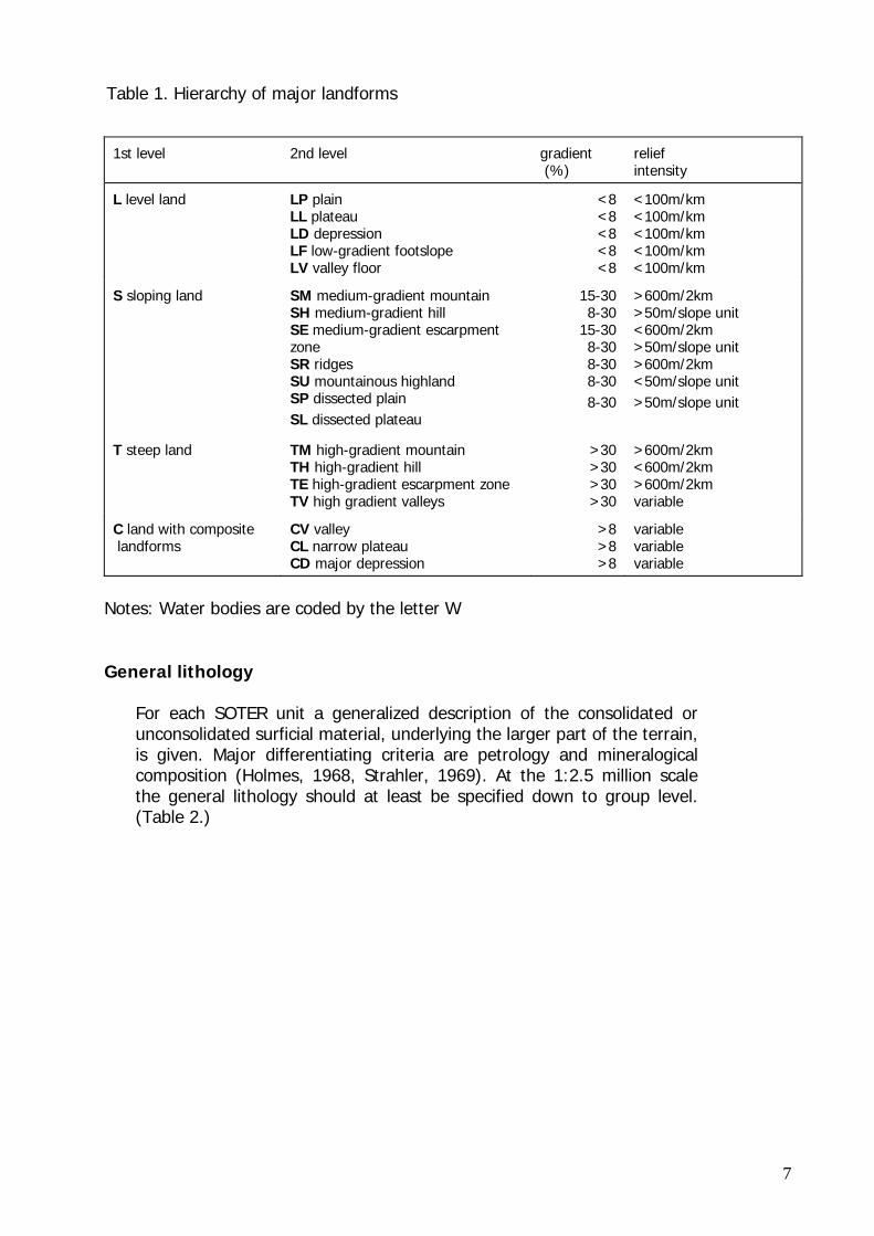
Table 1. Hierarchy of major landforms
1st level 2nd level gradient (%)
relief intensity
L level land LP plain LL plateau LD depression LF low-gradient footslope LV valley floor
<8 <8 <8 <8 <8
<100m/km <100m/km <100m/km <100m/km <100m/km
S sloping land SM medium-gradient mountain SH medium-gradient hill SE medium-gradient escarpment zone SR ridges SU mountainous highland SP dissected plain SL dissected plateau
15-30 8-30 15-30 8-30 8-30 8-30 8-30
>600m/2km >50m/slope unit <600m/2km >50m/slope unit >600m/2km <50m/slope unit >50m/slope unit
T steep land TM high-gradient mountain TH high-gradient hill TE high-gradient escarpment zone TV high gradient valleys
>30 >30 >30 >30
>600m/2km <600m/2km >600m/2km variable
C land with composite landforms
CV valley CL narrow plateau CD major depression
>8 >8 >8
variable variable variable
Notes: Water bodies are coded by the letter W General lithology
For each SOTER unit a generalized description of the consolidated or unconsolidated surficial material, underlying the larger part of the terrain, is given. Major differentiating criteria are petrology and mineralogical composition (Holmes, 1968, Strahler, 1969). At the 1:2.5 million scale the general lithology should at least be specified down to group level. (Table 2.)
7
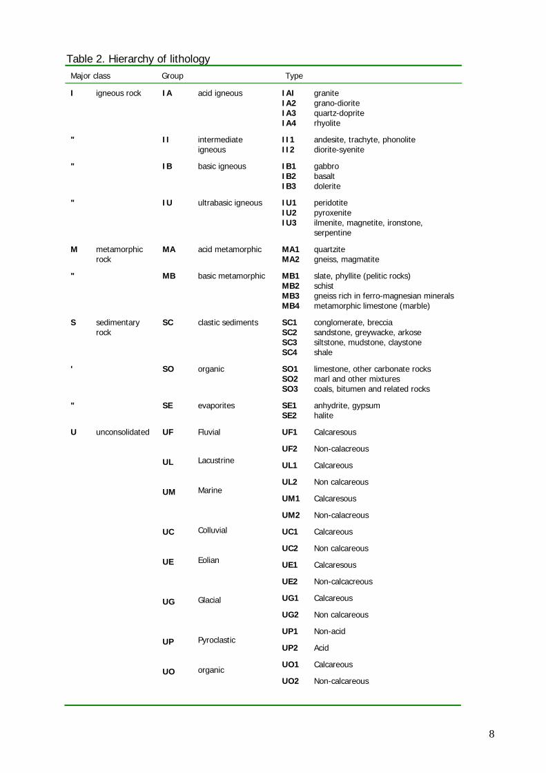
Table 2. Hierarchy of lithology Major class Group Type
I igneous rock IA acid igneous IAI IA2 IA3 IA4
granite grano-diorite quartz-doprite rhyolite
" II intermediate igneous
II1 II2
andesite, trachyte, phonolite diorite-syenite
" IB basic igneous IB1 IB2 IB3
gabbro basalt dolerite
" IU ultrabasic igneous IU1 IU2 IU3
peridotite pyroxenite ilmenite, magnetite, ironstone, serpentine
M metamorphic rock
MA acid metamorphic MA1 MA2
quartzite gneiss, magmatite
" MB basic metamorphic MB1 MB2 MB3 MB4
slate, phyllite (pelitic rocks) schist gneiss rich in ferro-magnesian minerals metamorphic limestone (marble)
S sedimentary rock
SC clastic sediments SC1 SC2 SC3 SC4
conglomerate, breccia sandstone, greywacke, arkose siltstone, mudstone, claystone shale
' SO organic SO1 SO2 SO3
limestone, other carbonate rocks marl and other mixtures coals, bitumen and related rocks
" SE evaporites SE1 SE2
anhydrite, gypsum halite
U unconsolidated UF UL UM UC UE UG UP UO
Fluvial
Lacustrine Marine Colluvial Eolian Glacial Pyroclastic organic
UF1
UF2
UL1
UL2
UM1
UM2
UC1
UC2
UE1
UE2
UG1
UG2
UP1
UP2
UO1
UO2
Calcaresous
Non-calacreous
Calcareous
Non calcareous
Calcaresous
Non-calacreous
Calcareous
Non calcareous
Calcaresous
Non-calcacreous
Calcareous
Non calcareous
Non-acid
Acid
Calcareous
Non-calcareous
8

3. MAJOR SOILS AND THEIR POTENTIAL FOR AGRICULTURE Figure 1 presents major soil units of Tanzania as compiled at a scale of 1:2,000,000. Table 1 summarises the major soil groups and their coverage in Tanzania. Tanzania adopted the World Reference Base for Soil Resources (WRB) as the system for soil nomenclature and correlation. Since then new material has become available, the FAO/UNESCO Soil Map of the World has been partly updated under the SOTER Programme and the FAO legend has been replaced by the World Reference Base for Soil Resources (WRB). The updating exercise covered: • The switch from the original map projection to a Flat Polar Quartic projection • The conversion of the FAO legend into the WRB classification • The incorporation of additional soil data obtained from new or revised soil map
sources • The matching, when possible of soil unit boundaries with major landforms According to the WRB, Tanzania has 19 dominant soil types. The structure, concepts and definitions of the WRB are strongly influenced by (the philosophy behind and experience gained with) the FAO-Unesco Soil Classification System. The dominant soil types are presented in Table 3. The major soil group Gypsisols does not appear in the SOTERSAF Database for Tanzania. It has been included in this account due to its significance to the Cement Industry. Table 3. Major soil groups of Tanzania Map code Major soil group Sq. km Percent AC Acrisols 81642.50 8.63 AN Andosols 15904.46 1.68 AR Arenosols 21926.33 2.32 CM Cambisols 337353.69 35.64 CH Chernozems 4734.96 0.50 FR Ferralsols 59852.62 6.32 FL Fluvisols 26223.13 2.77 GL Gleysols 1486.19 0.16 HS Histosols 3791.45 0.40 LP Leptosols 76738.02 8.11 LX Lixisols 46888.61 4.95 LV Luvisols 68706.15 7.26 NT Nitisols 21001.11 2.22 PH Phaeozems 22190.10 2.34 PL Planosols 28197.84 2.98 RG Regosols 1196.15 0.13 SC Solonchaks 2750.92 0.29 SN Solonetz 19626.46 2.07 VR Vertisols 47497.85 5.02 Water bodies 58836.73 6.22
9
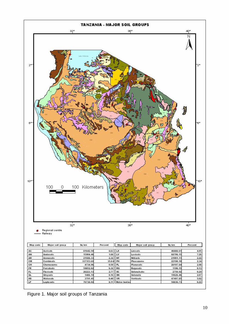
Figure 1. Major soil groups of Tanzania
10
3.1 Organic soils Histosols (HS) (3791.45 km2; 0.40%)
Histosols occur in Kigoma, Shinyanga, Kagera and Kilimanjaro regions. The Reference Soil Group of the Histosols comprises soils formed in `organic soil materials'. These vary from soils developed in (predominantly) moss peat and forest peat in temperate ecosystems to mangrove peat and swamp forest peat in the humid tropics. Histosols are found at all altitudes but the vast majority occurs in lowlands. Common international names are `peat soils', `muck soils', `bog soils' and `organic soils'.
Definition of Histosols
Soils,
1. having a histic or folic horizon, either 10 cm or more thick from the soil surface to a lithic* or paralithic* contact, or 40 cm or more thick and starting within 30 cm from the soil surface; and
2. having no andic or vitric horizon starting within 30 cm from the soil surface.
Common soil subunits in Tanzania are Fibric Histosols (HS-fi).
Summary description of Histosols Connotation: Peat and muck soils; from Gr. histos, tissue.
Parent material: Incompletely decomposed plant remains, with or without admixtures of sand, silt or clay.
Environment: Histosols occur extensively in boreal, arctic and subarctic regions. Elsewhere, they are confined to poorly drained basins, depressions, swamps and marshlands with shallow groundwater, and highland areas with a high precipitation/evapotranspiration ratio.
Profile development: Transformation of plant remains through biochemical disintegration and formation of humic substances creates a surface layer of mould. Translocated organic material may accumulate in deeper tiers but is more often leached from the soil.
Management and use of Histosols
Peat lands must be protected and conserved because of their intrinsic value and because prospects for sustained agricultural use are meager. If they must be used for plant production, sensible forms of forestry or plantation cropping are to be preferred over annual cropping, horticulture or, the ultimate nightmare, `harvesting' of the peat material for power generation or `production' of horticultural growth substrate, `active carbon', flower pots, etc. Peat lands that are used for arable crop production will mineralize at sharply increased rates because they must be drained, limed and fertilized to ensure satisfactory crop growth. It is particularly important to conserve the peat if loss of surface elevation may mean loss of land.
11
3.2 Mineral soils 3.2.1 Soils whose formation is conditioned by the particular properties of their parent material • Andosols are young soils whose formation is conditioned by the particular properties
of the volcanic deposits. • Arenosols are sandy soils featuring very weak or no soil development. They are
dominant in beach ridges, inland dunes, areas with highly weathered sandstone, etc.
• Vertisols are dark-coloured cracking and swelling clays. They occur in backswamps, river basins, lake bottoms, and other areas with a high content of expanding 2:1 lattice clays.
Andosols (AN) (15904.46 km2; 1.68%) Andosols occur in Arusha, Mara and Mbeya regions.
The Reference Soil Group of the Andosols holds soils developed in volcanic materials. Common international names are `Andosols' (FAO, Soil Map of the World), `Andisols' (USDA Soil Taxonomy), `Andosols' and `Vitrisols' (France) and `volcanic ash soils'.
Definition of Andosols
Soils having
1. a vitric or an andi horizon starting within 25 cm from the soil surface; and
2. no diagnostic horizons (unless buried deeper than 50 cm) other than a histic, fulvic, melanic, mollic, umbric, ochric, duric or cambic horizon.
Common soil subunits in Tanzania are Mollic Andosols (AN-mo), Umbric Andosols (AN-um) and Vitric Andosols (AN-vi). Summary description of Andosols Connotation: black soils of volcanic landscapes; from Jap. an, black, and do, soil.
Parent material: mainly volcanic ash, but also tuff, pumice, cinders and other volcanic ejecta.
Environment: undulating to mountainous, humid, arctic to tropical regions with a wide range of vegetation types.
Profile development: AC- or ABC-profile. Rapid weathering of porous volcanic material resulted in accumulation of stable organo-mineral complexes and short-range-order minerals such as allophane, imogolite and ferrihydrite.
Management and use of Andosols Andosols have a high potential for agricultural production but many are not used to their capacity. By and large, Andosols are fertile soils, particularly Andosols in intermediate or
12
basic volcanic ash and not exposed to excessive leaching. The strong phosphate fixation of Andosols is a problem. Ameliorative measures to reduce this effect (caused by active Al) include application of lime, silica, organic material and `phosphate' fertilizer.
Andosols are easy to till and have good rootability and water storage properties. Strongly hydrated Andosols may pose problems on account of their low bearing capacity and their stickiness.
Andosols in the tropics are planted to a wide variety of crops including sugarcane, tobacco, sweet potato (tolerant of low phosphate levels), tea, vegetables, wheat and orchard crops. Andosols on steep slopes are perhaps best kept under forest. Paddy rice cultivation is a major landuse on Andosols in lowlands with shallow groundwater. Elsewhere, continued paddy rice production has resulted in formation of a dense hardpan over accumulation layers of iron and manganese oxides; these hardpans reduce percolation losses of (irrigation) water.
Arenosols (AR) (21926.33 km2; 2.32%)
Arenosols occur in Tabora, Iringa, Mbeya and Rukwa regions and along the entire Indian ocean coastline.
The Reference Soil Group of the Arenosols consists of sandy soils, both soils developed in residual sands, in situ after weathering of old, usually quartz-rich soil material or rock, and soils developed in recently deposited sands as occur in deserts and beach lands. Many Arenosols correlate with Psamments and Psammaquents of the USDA Soil Taxonomy. Deep sandy soils with an argic or a spodic horizon within 200 cm from the surface are `Grossarenic' subgroups within the Alfisol, Ultisol and Spodosol orders. In the French classification system (CPCS, 1967), Arenosols correlate with taxa within the "Classe des sols minéraux bruts" and the "Classe des sols peu évolués". Other international soil names to indicate Arenosols are `siliceous, earthy and calcareous sands' and various `podsolic soils' (Australia), `red and yellow sands' (Brazil) and the Arenosols of the FAO Soil Map of the World.
Definition of Arenosols
Soils, having
1. a texture, which is loamy sand or coarser either to a depth of at least 100 cm from the soil surface, or to a plinthic, petroplinthic or salic horizon between 50 and 100 cm from the soil surface; and
2. less than 35 percent (by volume) of rock fragments or other coarse fragments within 100 cm from the soil surface; and
3. no diagnostic horizons other than an ochric, yermic or albic horizon, or a plinthic, petroplinthic or salic horizon below 50 cm from the soil surface.
Common soil subunits in Tanzania are Albi-Gleyic Arenosols (AR-gl-ab).
Summary description of Arenosols Connotation: sandy soils; from L. arena, sand.
Parent material: unconsolidated, in places calcareous, translocated sand; relatively small areas of Arenosols occur on residual sandstone or siliceous rock weathering.
13

Environment: from arid to (per)humid and from extremely cold to extremely hot; landforms vary from recent dunes, beach ridges and sandy plains under scattered (mostly grassy) vegetation, to very old plateaus under light forest.
Profile development: A(E)C profiles. In the dry zone, an ochric surface horizon is the only diagnostic horizon. Arenosols in the perhumid tropics tend to develop thick albic eluviation horizons; most Arenosols of the humid temperate zone show signs of alteration or transport of humus, iron or clay, but too weak to be diagnostic.
Management and use of Arenosols Arenosols occur in vastly different environments and possibilities to use them for agriculture vary accordingly. All Arenosols have a coarse texture, accountable for the generally high permeability and low water and nutrient storage capacity. Arenosols are further marked by ease of cultivation, rooting and harvesting of root and tuber crops.
• Arenosols in arid lands, where the annual rainfall sum is less than 300 mm, are predominantly used for extensive (nomadic) grazing. Dry farming is possible where the annual rainfall sum exceeds 300 mm. Low coherence, low nutrient storage capacity and high sensitivity to erosion are serious limitations of Arenosols in the dry zone. Good yields of small grains, melons, pulses and fodder crops have been realized on irrigated Arenosols but high percolation losses may make surface irrigation impracticable. Drip or trickle irrigation, combined with careful dosage of fertilizers, may remedy the situation. Uncontrolled grazing and clearing for cultivation without appropriate soil conservation measures can easily make these soils unstable and revert the land to shifting dune areas.
• Arenosols in the (sub)humid zone have similar limitations as the Arenosols of the dry zone albeit that drought is a less serious constraint. In some instances, e.g. in horticulture, the low water storage of Arenosols is considered advantageous because the soils warm up early in the season. In (much more common) mixed farming systems with cereals, fodder crops and grassland, supplemental sprinkler irrigation is applied to prevent drought stress during dry spells. Arenosols can aslo be kept under forest, either production forest or `natural' stands in carefully managed `nature' reserves.
• Arenosols in the humid area are best left under their natural vegetation, particularly so the deeply weathered Albic Arenosols. As nutrient elements are all concentrated in the biomass and in the top 20 cm of the soil, removal of the vegetation inevitably results in infertile badlands without ecological or economic value. Under forest, the land can still produce some timber (e.g. Agathis spp.) and wood for the pulp and paper industry. Permanent cultivation of annual crops would require management inputs that are usually not economically justifiable. In places, Arenosols have been planted to perennial crops such as rubber and pepper; coastal sands are widely planted to estate crops such as coconut, cashew, casuarina and pine, especially where good quality groundwater is within reach of the root system. Root and tuber crops benefit from the ease of harvesting, notably cassava, with its tolerance of
14

low nutrient levels. Groundnut and bambara groundnut can be found on the better soils.
Vertisols (VR) (47497.85 km2; 5.02%)
Vertisols occur in considerable proportions in Mwanza, Shinyanga, Mara, Tabora, Kigoma, Coast and Lindi regions.
Vertisols are churning heavy clay soils with a high proportion of swelling 2:1 lattice clays. These soils form deep wide cracks from the surface downward when they dry out, which happens in most years. The name Vertisols (from L. vertere, to turn) refers to the constant internal turnover of soil material. Some of the many local names became internationally known, e.g. `black cotton soils' (USA), `regur' (India), `vlei soils' (South Africa), `margalites (Indonesia), and `gilgai' (Australia).
Definition of Vertisols
Soils having
1. a vertic horizon within 100 cm from the soil surface, and
2. after the upper 20 cm have been mixed, 30 percent or more clay in all horizons to a depth of 100 cm or more, or to a contrasting layer between 50 and 100 cm (e.g. a lithic or paralithic contact, petrocalcic, petroduric or petrogypsic horizons, or a sedimentary discontinuity), and
3. cracks, which open and close periodically.
Common soil subunits in Tanzania are Chromi-Natric Vertisols (VR-na-cr), Eutri-Pellic Vertisols (VR-pe-eu) and Pellic Vertisols (VR-pe).
Summary description of Vertisols Connotation: churning heavy clay soils; from L. vertere, to turn.
Parent material: sediments that contain a high proportion of smectitic clay, or products of rock weathering that have the characteristics of smectitic clay.
Environment: depressions and level to undulating areas, mainly in tropical, semi-arid to (sub)humid and Mediterranean climates with an alternation of distinct wet and dry seasons. The climax vegetation is savanna, natural grassland and/or woodland.
Profile development: A(B)C-profiles. Alternate swelling and shrinking of expanding clay results in deep cracks during the dry season, and formation of `slickensides' and wedge-shaped structural elements in the subsurface soil.
Management and use of Vertisols
Vertisols become very hard in the dry season and are sticky in the wet season. Tillage is difficult, except for a short period at the transition between the wet and dry seasons. Vertisols are productive soils if properly managed.
15

Vertisols in Tanzania have moderate to high natural fertility but often associated with salinity and sodicity in some places. They are used for cultivation of annual crops such as rice, maize, cotton, sugarcane and vegetables. They also serve as important source of natural pasture for extensive grazing. Salt-build up and overgrazing are the important cause of degradation in areas with Vertisols. 3.2.2 Soils whose formation was markedly influenced by their topographic setting In low terrain positions • Fluvisols are young soils in alluvial deposits. They show stratification or other
evidence of recent sedimentation. • Gleysols are soils with permanent or temporary wetness near the surface. They are
non-stratified and do not receive regular additions of sediment. In elevated and/or eroding areas • Leptosols are very shallow soils over hard rock or in unconsolidated very gravelly
material. Their topographic setting markedly influenced soil formation. Profile development is hindered by erosion
• Regosols are soils with very limited soil development. They occur in unconsolidated materials and which have only surficial profile development because of erosion.
Fluvisols (FL) (26223.13 km2; 2.77%)
Fluvisols are dominant soils in the plains associated with important river plains in Tanzania such as the Rufiji basin, Ruaha basin, Ruvu basin, kilombeo basin and Wami basin.
The Reference Soil Group of the Fluvisols accommodates genetically young, azonal soils in alluvial deposits. The name `Fluvisols' is misleading in the sense that these soils are not confined to river sediments (L. fluvius means `river') but occur also in lacustrine and marine deposits. Many international soil names refer to this group, for example: `Alluvial soils' (Russia, Australia), `Fluvents' (USDA Soil Taxonomy), `Fluvisols' (FAO), Auenböden (Germany) and `Sols minéraux bruts d'apport alluvial ou colluvial' or `Sols peu évolués non climatiques d'apport alluvial ou colluvial' (France).
Definition of Fluvisols
Soils having
1. a thickness of 25 cm or more, and
2. fluvic soil material starting within 50 cm from the soil surface and continuing to a depth of at least 50 cm from the soil surface; and
3. no diagnostic horizons other than a histic, mollic, ochric, takyric, umbric, yermic, salic or sulfuric horizon.
Common soil subunits in Tanzania are Eutri-Gleyic Fluvisols (FL-gl-eu).
16

Summary description of Fluvisols
Connotation: soils developed in alluvial deposits; from L. fluvius, river.
Parent material: (predominantly) recent, fluvial, lacustrine or marine deposits.
Environment: periodically flooded areas (unless empoldered) of alluvial plains, river fans, valleys and (tidal) marshes, on all continents and in all climate zones.
Profile development: AC-profiles with evidence of stratification; weak horizon differentiation but a distinct Ah-horizon may be present. Redoximorphic features are common, in particular in the lower part of the profile.
Management and use of Fluvisols Fluvisols are planted to annual crops and orchards and many are used for grazing. Flood control, drainage and/or irrigation are normally required. Paddy rice and sugarcane cultivation is widespread on the Fluvisols with satisfactory irrigation and drainage in Tanzania. In order to sustain productivity, paddy land should be dry for at least a few weeks every year, to prevent the soil's redox potential from becoming so low that nutritional problems (iron, H2S) arise. A dry period also stimulates microbial activity and promotes mineralization of organic matter. Many dryland crops are grown on Fluvisols, normally with some form of artificial water control.
Tidal lands that are strongly saline are best kept under mangroves or other salt tolerant vegetation. Such areas are ecologically valuable and can be used (with caution!) for fishing, hunting, salt pans, or woodcutting for charcoal or firewood.
Gleysols (GL) (1486.19 km2; 0.16%)
The Reference Soil Group of the Gleysols holds wetland soils that, unless drained, are saturated with groundwater for long enough periods to develop a characteristic "gleyic colour pattern". This pattern is essentially made up of reddish, brownish or yellowish colours at ped surfaces and/or in the upper soil layer(s), in combination with greyish/bluish colours inside the peds and/or deeper in the soil. Common international names are `Gleyzems' and `meadow soils' (Russia), `Aqu-` suborders of Entisols, Inceptisols and Mollisols (USA), `Gley' (Germany), and `groundwater soils' and `hydro-morphic soils'.
Definition of Gleysols
Soils,
1. having gleyic properties within 50 cm from the soil surface; and
2. having no diagnostic horizons other than an anthraquic, histic, mollic, ochric, takyric, umbric, andic, calcic, cambic, gypsic, plinthic, salic, sulfuric or vitric horizon within 100 cm from the soil surface.
3. having no abrupt textural change within 100 cm from the surface.
Common soil subunits in Tanzania are Epi-Dystric Gleyisols (GL-dye)
17

Summary description of Gleysols Connotation: soils with clear signs of excess wetness; from R. gley, mucky mass.
Parent material: a wide range of unconsolidated materials, mainly fluvial, marine and lacustrine sediments of Pleistocene or Holocene age, with basic to acidic mineralogy.
Environment: depression areas and low landscape positions with shallow groundwater.
Profile development: mostly A(Bg)Cr or H(Bg)Cr profiles. Evidence of reduction processes with or without segregation of iron compounds within 50 cm of the surface.
Management and use of Gleysols The main obstacle to utilisation of Gleysols is the necessity to install a drainage system, designed to either lower the groundwater table, or intercept seepage or surface runoff water. Adequately drained Gleysols can be used for arable cropping, dairy farming or horticulture.
Soil structure will be destroyed for a long time if (too) wet soils are tilled. Gleysols in (depression) areas with unsatisfactory drainage possibilities are therefore best kept under permanent grass cover or (swamp) forest. Liming of drained Gleysols that are high in organic matter and/or of low pH value creates a better habitat for micro- and meso-organisms and enhances the rate of soil organic matter decomposition (and the supply of plant nutrients).
Gleysols can be put under tree crops only after the water table has been lowered with deep drainage ditches. Alternatively, the trees are planted on ridges that alternate with shallow depressions where rice can be grown.
Leptosols (LP) (76738.02 km2; 8.11%)
Leptosols are the third largest soils in terms of coverage in the country. They are mostly associated with mountainous landscapes and steep terrains, particularly in Kagera, Arusha, Singida, Dodoma, Mbeya, Rukwa, Iringa and Lindi regions.
Common soil subunits in Tanzania are Eutric Leptosols (LP-eu) and Humi-Umbric Leptosols (LP-um-hu).
Management and use of Leptosols Important land uses are extensive grazing and stone quarrying. They are suitable for forestry and nature conservation. Regosols (RG) (1196.15 km2; 0.13%) Regosols are of very limited occurrence in the country. They are found in Zanzibar and parts of Arusha region. Common soil subunits in Tanzania are Eutri-Humic Regosols (RG-hu-eu).
18

Management and use of Regosols They are not used for cultivation but mainly serve as source of murram for various civil works. 3.2.3 Soils that are only moderately developed on account of their limited pedogenetic age or because of rejuvenation of the soil material • Cambisols are weakly to moderately developed soils occurring from sea level to the
highlands and under all kinds of vegetation. They have not more in common than `signs of beginning soil formation' so that there is considerable diversity among the soils in this set.
Cambisols (CM) (337353.69 km2; 35.64%)
Cambisols are the most extensive soils in the country, covering 35.64% of the area. They occur mainly in the mid-western and south-eastern parts of the country.
The Reference Soil Group of the Cambisols holds soils with incipient soil formation. Beginning transformation of soil material is evident from weak, mostly brownish discolouration and/or structure formation below the surface horizon. Early soil classification systems referred to these `brown soils' as `Braunerde' (Germany), `Sols bruns' (France), `Brown soils'/`Brown Forest soils' (USA), or `Brunizems' (Russia). FAO coined the name `Cambisols'; USDA Soil Taxonomy classifies these soils as `Inceptisols'.
Definition of Cambisols
Soils having
• a cambic horizon; or
• a mollic horizon overlying subsoil with low base saturation within 100 cm depth; or
• one of the following:
• an andic, vertic or vitric horizon starting between 25 and 100 cm below the surface; or
• a plinthic, petroplinthic or salic or sulfuric horizon starting between 50 and 100cm below the soil surface, in the absence of loamy sand or coarser material above these horizons.
Common soil subunits in Tanzania are Chromi-Ferralic Cambisols (CM-fl-cr), Eutri-Rhodic Cambisols (CM-ro-eu), Eutric Cambisols (CM-eu), Ferralic Cambisols (CM-fl), Rhodic cambisols (CM-ro) and Sodi-Mollic Cambisols (CM-mo-so).
Summary description of Cambisols Connotation: soils with beginning horizon differentiation evident from changes in colour, structure or carbonate content; from L. cambiare, to change.
Parent material: medium and fine-textured materials derived from a wide range of rocks, mostly in colluvial, alluvial or aeolian deposits.
19

Profile development: ABC profiles. Cambisols are characterized by slight or moderate weathering of parent material and by absence of appreciable quantities of illuviated clay, organic matter, aluminium and/or iron compounds.
Environment: level to mountainous terrain in all climates and under a wide range of vegetation types.
Management and use of Cambisols Cambisols make good agricultural land and are intensively used. The Eutric Cambisols are among the most productive soils on earth. The Cambisols, though less fertile, are used for (mixed) arable farming and as grazing land. Cambisols on steep slopes are best kept under forest; this is particularly true for Cambisols in highlands.
Eutric and Chromic Cambisols in undulating or hilly (mainly colluvial) terrain are planted to a variety of annual and perennial crops or are used as grazing land. Ferralic and Rhodic Cambisols in the humid areas are poor in nutrients but still richer than associated Acrisols or Ferralsols and they have a greater cation exchange capacity. Cambisols in alluvial plains make productive `paddy soils'.
3.2.4 The `typical' red and yellow soils of wet tropical and subtropical regions High soil temperatures and (at times) ample moisture promote rock weathering and rapid decay of soil organic matter. The Reference Soil Groups in this set have in common that a long history of dissolution and transport of weathering products has produced deep and genetically mature soils. • Deeply weathered Ferralsols that have a very low cation exchange capacity and are
virtually devoid of weatherable minerals • Deep Nitisols in relatively rich parent material and marked by shiny, nutty structure
elements, • Strongly leached, red and yellow Acrisols on acid parent rock, with a clay
accumulation horizon, low cation exchange capacity and low base saturation • Lixisols with a low cation exchange capacity but high base saturation
Ferralsols (FR) (59852.62 km2; 6.32%)
Ferralsols are scattered throughout the country but occur mainly in Kigoma, Rukwa, Mbeya, Morogoro, Tanga, Kilimanjaro, Dar es Salaam and Mtwara regions.
The Reference Soil Group of the Ferralsols holds the `classical', deeply weathered, red or yellow soils of the humid tropics. These soils have diffuse horizon boundaries, a clay assemblage dominated by low activity clays (mainly kaolinite) and a high content of sesquioxides. Local names usually refer to the colour of the soil. Internationally, Ferralsols are known as Oxisols (Soil Taxonomy, USA), Latosols (Brazil), Sols ferralitiques (France), Lateritic soils, Ferralitic soils (Russia) and Ferralsols (FAO).
20

Definition of Ferralsols
Soils
1. having a ferralic horizon at some depth between 25 and 200 cm from the soil surface, and
2. lacking a nitic horizon within 100 cm from the soil surface, and
3. lacking an argic horizon that has 10 percent or more water-dispersible clay within 30 cm from its upper boundary unless the soil material has geric properties or contains more than 1.4 percent organic carbon.
Common soil subunits in Tanzania are Haplic Ferralsols (FR-ha).
Summary description of Ferralsols Connotation: red and yellow tropical soils with a high content of sesquioxides; from L. ferrum, iron and aluminium, alum.
Parent material: strongly weathered material on old, stable geomorphic surfaces; more in weathering material from basic rock than in siliceous material.
Environment: typically in level to undulating land of Pleistocene age or older; less common on younger, easily weathering rocks. Perhumid or humid tropics; minor occurrences elsewhere are considered to be relics from past eras with a wetter climate than today.
Profile development: ABC profiles. Deep and intensive weathering has resulted in a high concentration of residual, resistant primary minerals alongside sesquioxides and well-crystallized kaolinite. This mineralogy and the low pH explain the stable microstructure (pseudo-sand) and yellowish (goethite) or reddish (hematite) soil colours.
Management and use of Ferralsols
Most Ferralsols in Tanzania have good physical properties. Great soil depth, good permeability and stable microstructure make Ferralsols less susceptible to erosion than most other intensely weathered red tropical soils. Moist Ferralsols are friable and easy to work. They are well drained but may in times be droughty because of their low water storage capacity.
The chemical fertility of Ferralsols is poor; weatherable minerals are absent and cation retention by the mineral soil fraction is weak. Under natural vegetation, nutrient elements that are taken up by the roots are eventually returned to the surface soil with falling leaves and other plant debris. The bulk of all cycling plant nutrients is contained in the biomass; `available' plant nutrients in the soil (and all living plant roots) are concentrated in the upper 10 to 50 cm soil layer. If the process of `nutrient cycling' is interrupted, e.g. after introduction of low input sedentary subsistence farming, the root zone will rapidly become depleted of plant nutrients. Maintaining soil fertility by manuring, mulching and/or adequate (i.e. long enough) fallow periods and prevention of surface soil erosion are important management requirements.
Strong retention (`fixing') of phosphorus is a problem of Ferralsols (and several other soils, e.g. Andosols). Ferralsols are normally also low in nitrogen, potassium, secondary nutrients (calcium, magnesium, sulphur) and a score of micro-nutrients. Even silica
21
deficiency is possible if silica-demanding crops (e.g. grasses) are grown. Manganese and zinc, which are very soluble at low pH, may at some time reach toxic levels in the soil or become deficient after intense leaching of the soil.
Liming is a means to raise the pH-value of the rooted surface soil. Liming combats aluminium toxicity and raises the CEC. On the other hand, it lowers the AEC, which might lead to collapse of structure elements and slaking at the soil surface. Frequent small doses of lime or basic slag are therefore preferable over one massive application; 0.5 - 2 tons/ha of lime, or dolomite, are normally enough to supply calcium as a nutrient and to buffer the low soil-pH of Ferralsols.
Fertilizer selection and the mode/timing of fertilizer application determine to a great extent the success of agriculture on Ferralsols. Slow-release (rock) phosphate applied at a rate of several tons per hectare eliminates phosphorus deficiency for a number of years. For a quick fix, much more soluble (Double or Triple) Super Phosphate is used, needed in much smaller quantities, especially if placed in the direct vicinity of the roots.
Sedentary subsistence farmers and shifting cultivators on Ferralsols grow a variety of annual and perennial crops. Low volume grazing is also common and considerable areas of Ferralsols are not used for agriculture at all. The good physical properties of Ferralsols and the often level topography would encourage more intensive forms of land use if problems caused by the poor chemical soil properties could be overcome.
Nitisols (NT) (21001.11 km2; 2.22%)
Nitisols occur in Mbeya, Iringa, Manyara, Kilimanjaro and Mara regions.
The Reference Soil Group of the Nitisols accommodates deep, well-drained, red, tropical soils with diffuse horizon boundaries and a subsurface horizon with more than 30 percent clay and moderate to strong angular blocky structure elements that easily fall apart into characteristic shiny, polyhedric (`nutty') elements. Nitisols are strongly weathered soils but far more productive than most other red tropical soils. Nitisols correlate with `Terra roxa estruturada' (Brazil), kandic groups of Alfisols and Ultisols (Soil Taxonomy, USA), `Sols Fersialitiques' or `Ferrisols' (France) and with the `Red Earths'.
Definition of Nitisols
Soils,
1. H1. having a nitic horizon starting within 100 cm from the soil surface, and
2. H2. having gradual to diffuse horizon boundaries, and
3. L3. lacking a ferric, plinthic or vertic horizon within 100 cm from the soil surface.
Common soil subunits in Tanzania areEutric Nitisols (NT-eu), Haplic Nitisols (NT-ha) and Humi-Umbric Nitisols (NT-um-hu).
22

Summary description of Nitisols
Connotation: deep, red, well-drained tropical soils with a clayey `nitic' subsurface horizon that has typical `nutty', polyhedric, blocky structure elements with shiny ped faces; from L. nitidus, shiny.
Parent material: finely textured weathering products of intermediate to basic parent rock, possibly rejuvenated by recent admixtures of volcanic ash. The clay assemblage of Nitisols is dominated by kaolinite/(meta)halloysite. Nitisols are rich in iron and have little water-dispersible (`natural') clay.
Environment: Nitisols are predominantly found in level to hilly land under tropical rain forest or savannah vegetation.
Profile development: AB(t)C-profiles. Red or reddish brown clayey soils with a `nitic' subsurface horizon of high aggregate stability.
Management and use of Nitisols Nitisols are among the most productive soils of the humid tropics. The deep and porous solum and the stable soil structure of Nitisols permit deep rooting and make these soils quite resistant to erosion. The good workability of Nitisols, their good internal drainage and fair water holding properties are complemented by chemical (fertility) properties that compare favourably to those of most other tropical soils. Nitisols have relatively high contents of weathering minerals and surface soils may contain several percent of organic matter, in particular under forest or tree crops.
In Tanzania Nitisols are planted to plantation crops such as tea, coffee, rubber and pineapple, and are also widely used for food crop production on smallholdings. High P-sorption calls for application of P-fertilizer, usually provided as slow release, low-grade `rock phosphate' (several tons/ha with maintenance doses every few years) in combination with smaller applications of better soluble `super phosphate' for short-term response by the crop.
Acrisols (AC) (81642.50 km2; 8.63%)
Acrisols are the second most extensive soils in the country. They occur in Mara, Tabora, Singida, Dodoma, Tanga, Kilimanjaro, Morogoro, Iringa, Mbeya, Ruvuma, Lindi and Mtwara regions.
The Reference Soil Group of the Acrisols holds soils that are characterized by accumulation of low activity clays in an argic subsurface horizon and by a low base saturation level. Acrisols correlate with `Red-Yellow Podzolic soils' (e.g. Indonesia), `Podzolicos vermelho-amarello distroficos a argila de atividade baixa' (Brazil), `Sols ferralitiques fortement ou moyennement désaturés' (France), `Red and Yellow Earths' and with several subgroups of Alfisols and Ultisols (Soil Taxonomy, USA).
23
Definition of Acrisols
Soils,
1. having an argic horizon, which has a cation exchange capacity (in 1 M NH4OAc at pH 7.0) of less than 24 cmol(+) kg-1 clay in some part, either starting within 100 cm from the soil surface, or within 200 cm from the soil surface if the argic horizon is overlain by loamy sand or coarser textures throughout, and
2. having less than 50 percent base saturation (in 1M NH4OAc at pH 7.0) in the major part between 25 and 100 cm.
Common soil subunits in Tanzania are Chromi-Ferric Acrisols (AC-fr-cr).
Summary description of Acrisols Connotation: strongly weathered acid soils with low base saturation; from L. acris, very acid.
Parent material: most extensive on acid rock weathering, notably in strongly weathered clays, which are undergoing further degradation.
Environment: mostly old land surfaces with hilly or undulating topography, in regions with a wet tropical/monsoonal, subtropical or warm temperate climate. Light forest is the natural vegetation type.
Profile development: AEBtC-profiles. Variations in Acrisols will normally correlate with variations in terrain conditions (drainage, seepage). A shallow A-horizon with dark, raw and acid organic matter grades into a yellowish E-horizon. The underlying argic Bt-horizon has stronger reddish or yellowish colour than the E-horizon.
Management and use of Acrisols Preservation of the surface soil with its all-important organic matter is a precondition for farming on Acrisols. Mechanical clearing of natural forest by extraction of root balls and filling of the holes with surrounding surface soil produces land that is largely sterile because toxic levels of aluminium (the former subsoil) kill any seedlings planted outside the filled-in spots.
Adapted cropping systems with complete fertilization and careful management are required if sedentary farming is to be practiced on Acrisols. The widely used `slash and burn' agriculture (`shifting cultivation') may seem primitive at first sight but is really a well adapted form of land use, developed over centuries of trial and error. If occupation periods are short (one or a few years only) and followed by a sufficiently long regeneration period (up to several decades), this system probably makes the best use of the limited resources of Acrisols.
Low-input farming on Acrisols is not very rewarding. Undemanding, acidity-tolerant cash crops such as pineapple, cashew or rubber can be grown with some success. Increasing areas of Acrisols are planted to oil palm (e.g. in Malaysia and on Sumatra). Large areas of Acrisols are (still) under forest, ranging from high, dense rain forest to open woodland. Most of the tree roots are concentrated in the humous surface horizon with only few taproots extending down into the subsoil. Acrisols are suitable for
24

production of rain-fed and irrigated crops only after liming and full fertilization. Rotation of annual crops with improved pasture maintains the organic matter content.
Lixisols (LX) (46888.61 km2; 4.95%)
Lixisols are important soils in Iringa, Mbeya, Ruvuma, Lindi and Mtwara regions.
The Reference Soil Group of the Lixisols consists of strongly weathered soils in which clay has washed out of an eluvial horizon (L. lixivia is washed-out substances) down to an argic subsurface horizon that has low activity clays and a moderate to high base saturation level. Lixisols were formerly included in the `Red-Yellow Podzolic soils' (e.g. Indonesia), `Podzolicos vermelho-amarello eutroficos a argila de atividade baixa' (Brazil), `Sols ferralitiques faiblement désaturés appauvris' and `Sols ferrugineux tropicaux lessivés' (France), `Red and Yellow Earths', `Latosols' or classified as oxic subgroups of Alfisols (Soil Taxonomy, USA).
Definition of Lixisols
Soils having an argic horizon starting within 100cm from the soil surface, or within 200 cm from the soil surface if the argic horizon is overlain by loamy sand or coarser textures throughout.
Common soil subunits in Tanzania are Chromi-Arenic Lixisols (LX-ar-cr), Chromic Lixisols (LX-cr), Haplic Lixisols (LX-ha), Rhodi-Profondic Lixisols (LX-pf-ro), Rhodic Lixisols (LX-ro).
Summary description of Lixisols Connotation: strongly weathered soils in which clay is washed down from the surface soil to an accumulation horizon at some depth; from L. lixivia, washed-out substances.
Parent material: unconsolidated, strongly weathered and strongly leached, finely textured materials.
Environment: regions with a tropical, subtropical or warm temperate climate with a pronounced dry season, notably on old erosional or depositional surfaces. Many Lixisols are (surmised to be) polygenetic soils with characteristics formed under a more humid climate in the past.
Profile development: ABtC-profiles. On slopes and on other surfaces subject to erosion, the argic accumulation horizon may be exposed or at shallow depth.
Management and use of Lixisols Areas with Lixisols that are still under natural savannah or open woodland vegetation are widely used for low volume grazing. Preservation of the surface soil with its all-important organic matter is of utmost importance. Degraded surface soils have low aggregate stability and are prone to slaking and/or erosion if exposed to the direct impact of raindrops. Tillage of wet soil or use of (too) heavy machinery will compact the soil and cause serious structure deterioration. Tillage and erosion control measures such as terracing, contour ploughing, mulching and use of cover crops help to conserve the soil. The low absolute level of plant nutrients and the low cation retention by Lixisols makes recurrent inputs of fertilizers and/or lime a precondition for continuous
25

cultivation. Chemically and/or physically deteriorated Lixisols regenerate very slowly if not actively reclaimed.
By and large, perennial crops are to be preferred over annual crops, particularly on sloping land. Cultivation of tuber crops (cassava, sweet potato) or groundnut increases the danger of soil deterioration and erosion. Rotation of annual crops with improved pasture has been recommended to maintain or improve the soil's organic matter content (Deckers et al, 1998).
3.2.5 Reference Soil Groups in arid and semi-arid regions Redistribution of calcium carbonate and gypsum is an important mechanism of horizon differentiation in soils in the dry zone. Soluble salts may accumulate at some depth or, in areas with shallow groundwater, near the soil surface. • Gypsisols are soils with accumulation of secondary gypsum. • Solonchaks are strongly saline soils. • Solonetz are soils with subsurface clay accumulation, rich in sodium.
Gypsisols (GY) (No polygon)
Gypsisols occur in Same district (Makanya) along the vast Pangani river plain. This unit does not appear on the SOTERSAF Database for Tanzania.
Gypsisols are soils with substantial secondary accumulation of gypsum (CaSO4.2H2O). They are found in the driest parts of the arid climate zone, which explains why leading soil classification systems labeled them `Desert soils' (USSR), Aridisols (USDA Soil Taxonomy), Yermosols or Xerosols (FAO, 1974).
Definition of Gypsisols
Soils having
1. a gypsic or petrogypsic horizon within 100 cm from the surface; and
2. no diagnostic horizons other than an ochric horizon, a cambic horizon, an argic horizon permeated with gypsum or calcium carbonate, a vertic horizon, or a calcic or petrocalcic horizon underlying the gypsic or petrogypsic horizon.
Common soil subunits in Tanzania are Petric Gypsisols.
Summary description of Gypsisols Connotation: soils with substantial secondary accumulation of calcium sulphate; from L. gypsum, gypsum.
Parent material: mostly unconsolidated alluvial, colluvial or aeolian deposits of base-rich weathering material.
Environment: predominantly level to hilly land and depression areas (e.g. former inland lakes) in arid regions. The natural vegetation is sparse and dominated by xerophytic shrubs and trees and/or ephemeral grasses.
26
Profile development: AB(t)C profiles with a yellowish brown ochric surface horizon over a pale brown or whitish cambic or (relic ?) argic subsurface horizon. Accumulation of calcium sulphate, with or without carbonates, is concentrated in and below the B-horizon.
Management and use of Gypsisols Gypsisols that contain only little gypsum in the upper 30 cm soil layer can be used for production of small grains, cotton, etc. Dry farming on deep Gypsisols makes use of fallow years and other water harvesting techniques but is rarely rewarding under the adverse climate conditions. Many Gypsisols in (young) alluvial and colluvial deposits have relatively little gypsum. Such soils can be very productive if carefully irrigated. Even soils containing 25 percent powdery gypsum or more could still produce excellent yields of alfalfa hay (10 tons per hectare), wheat, apricots, dates, maize and grapes if irrigated at high rates in combination with forced drainage. Irrigated agriculture on Gypsisols is plagued by quick dissolution of soil gypsum resulting in irregular subsidence of the land surface, caving in canal walls, and corrosion of concrete structures. Dissolution of gypsum might also reduce the depth of a petrogypsic horizon to the extent that the hard pan obstructs root growth, and/or interferes with water supply to the crop and with soil drainage. Large areas with Gypsisols are in use for extensive grazing. Quite large amounts of gypsum are mined for the cement industry in Tanzania.
Solonchaks (SC) (2750.92 km2; 0.29%)
Solonchaks are common soils of the Pangani river basin in Kilimanjaro and Tanga regions.
The Reference Soil Group of the Solonchaks includes soils that have a high concentration of `soluble salts' at some time in the year. Solonchaks are largely confined to the arid and semi-arid climatic zones and to coastal regions in all climates. Common international names are `saline soils' and `salt-affected soils'.
Definition of Solonchaks
Soils,
1. having a salic horizon starting within 50 cm from the soil surface; and
2. lacking diagnostic horizons other than a histic, mollic, ochric, takyric, yermic, calcic, cambic, duric, gypsic or vertic horizon.
Common soil units in Tanzania are Carbonati-Sodic Solonchaks (SC-so-cn).
Summary description of Solonchaks Connotation: saline soils; from R. sol, salt, and R. chak, salty area.
Parent material: virtually any unconsolidated soil material.
Environment: arid and semi-arid regions, notably in seasonally or permanently waterlogged areas with grasses and/or halophytic herbs, and in poorly managed irrigation areas. Solonchaks in coastal areas occur in all climates.
Profile development: mostly AC or ABC profiles, often with gleyic properties at some depth. In low-lying areas with a shallow water table, salt accumulation is strongest at the surface of the soil (`external Solonchaks'). Solonchaks with a deep water table have
27
the greatest accumulation of salts at some depth below the surface (internal Solonchaks'). Management and use of Solonchaks Excessive accumulation of salts in soil affects plant growth in two ways:
1. The salts aggravate drought stress because dissolved electrolytes create an `osmotic potential' that affects water uptake by plants. Before any water can be taken up from the soil, plants must compensate the combined forces of the soil's `matrix potential', i.e. the force with which the soil matrix retains water, and the osmotic potential. As a rule of thumb (sic!) the osmotic potential of a soil solution (in hPa) amounts to some 650 * EC (in dS/m). The total potential that can be compensated by plants (known as the `critical leaf water head') varies strongly between plant species. Plant species that stem from the humid tropics have a comparatively low `critical leaf water head'. Green peppers, for instance, can compensate a total soil moisture potential (matrix plus osmotic forces) of only some 3,500 hPa whereas cotton, a crop that evolved in arid and semi-arid climates, survives some 25,000 hPa! Table 2 presents a widely used key for grading of salt affected soils with attention for the harmful effects of soil salinity on crop performance.
2. Dissolved salts upset the balance of ions in the soil solution; nutrients are proportionally less available. Antagonistic effects are known to exist, for example, between sodium and potassium, between sodium and calcium and between magnesium and potassium. In higher concentrations, the salts may be directly toxic to plants. Very harmful in this respect are sodium ions and chloride ions (disturb N-metabolism).
Strongly salt-affected soils have little agricultural value: they are used for extensive grazing of sheep, goats, camels and cattle or lie idle. Only after the salts have been flushed from the soil (which then ceases to be a Solonchak) may good yields be hoped for. Application of irrigation water must not only satisfy the needs of the crop but excess water must be applied above the irrigation requirement to maintain a downward water flow in the soil and flush excess salts from the root zone. Irrigation of crops in arid and semi-arid regions must be accompanied by drainage whereby drainage facilities should be designed to keep the groundwater table below the critical depth.
Solonetz (SN) (19626.46 km2; 2.07%)
Solonetz occur in Mara, Arusha, Singida, Dodoma, Iringa, Mbeya and Rukwa regions.
The Reference Soil Group of the Solonetz accommodates soils with a dense, strongly structured, clay illuviation horizon that has a high proportion of adsorbed sodium and/or magnesium ions. The name `Solonetz' (from R. sol, salt, and etz, strongly expressed) has become somewhat confusing now that most saline soils, with or without a high proportion of adsorbed sodium ions, key out as Solonchaks in the WRB key. Solonetz that contain free soda (Na2CO3) are strongly alkaline (field pH > 8.5). Internationally, Solonetz are referred to as `alkali soils' and `sodic soils', `Sols sodiques à horizon B et Solonetz solodisés' (France), Natrustalfs, Natrustolls, Natrixeralfs, Natrargids or Nadurargids (USA) and as Solonetz (USSR, Canada, FAO).
28
Definition of Solonetz
Soils having a natric horizon within 100 cm from the soil surface.
Common soil subunits in Tanzania are Calci-Gleyic Solonetz (SN-gl-cc),Calcic Solonetz (SN-cc), Mollic Solonetz (SN-mo) and Stagnic Solonetz (SN-st).
Summary description of Solonetz Connotation: Soils with a high content of exchangeable sodium and/or magnesium ions; from R. sol, salt, and etz, strongly expressed.
Parent material: unconsolidated materials, mostly fine-textured sediments.
Environment: Solonetz are normally associated with flat lands in a climate with hot, dry summers, or with (former) coastal deposits that contain a high proportion of sodium ions. Major concentrations of Solonetz are in flat or gently sloping grasslands with loess/loam or clay in semi-arid, temperate and subtropical regions.
Profile development: ABtnC and AEBtnC profiles with a black or brown surface soil over a natric horizon that starts at less than 100 cm from the soil surface. Well-developed Solonetz can have a (beginning) albic eluviation horizon directly over a natric horizon with strong round-topped columnar structure elements. A calcic or gypsic horizon may be present below the natric horizon. Many Solonetz have a field-pH above 8.5 indicative of the presence of free sodium carbonate.
Management and use of Solonetz The suitability of `virgin' Solonetz for agricultural uses is almost entirely dictated by the depth and properties of the surface soil. A `deep' (say >25 cm) humus-rich surface soil is needed for successful arable crop production. Unfortunately, most Solonetz have only a much shallower surface horizon, or have lost the surface horizon altogether.
Solonetz amelioration has two basic elements:
1. improvement of the porosity of the (sub)surface soil, and
2. lowering of the ESP.
Most reclamation attempts start with incorporation of gypsum or, exceptionally, calcium chloride in the soil. Where lime or gypsum occur at shallow depth in the soil body, deep ploughing (mixing the carbonate or gypsum containing subsoil with the surface soil) may make expensive amendments superfluous. Traditional reclamation strategies start with the planting of a sodium-resistant crop, e.g. Rhodes grass, to gradually improve the permeability of the soil. Once a functioning pore system is in place, sodium ions are carefully leached from the soil with `good quality' (calcium-rich) water.
An extreme reclamation method, which was developed in Armenia and successfully applied to Calcic Solonetz soils in the Arax river valley, uses diluted sulphuric acid (a waste product of the metallurgical industry) to dissolve CaCO3 contained in the soil. This adds calcium ions to the soil solution, which repel sodium ions from the soil's exchange complex. The practice improves soil aggregation and soil permeability. The resulting sodium sulphate (in the soil solution) is subsequently flushed out of the soil.
29
3.2.6 Soils that occur in the steppe zone between the dry climates and the humid Temperate Zone This transition zone has climax vegetation of ephemeral grasses and dry forest. Its location corresponds roughly with the transition from a dominance of accumulation processes in soil formation to a dominance of leaching processes. • Chernozems are deep soils with a thick, black topsoil, rich in organic matter and
carbonate enrichment in the subsoil. • Phaeozems are soils with a thick, dark topsoil rich in organic matter and evidence of
removal of carbonates. but no visible signs of secondary carbonate accumulation.
Chernozems (CH) (4734.96 km2; 0.50%)
Chernozems are limited in extent and occur in Arusha and Kilimanjaro regions.
The Reference Soil Group of the Chernozems accommodates soils with a thick black surface layer rich in organic matter. Russian soil scientist Dokuchaev coined the name "Chernozems" in 1883 to denote the typical "zonal" soil of the tall grass steppes in continental Russia. Some international synonyms: `Calcareous Black Soils', `Eluviated Black Soils' (Canada), and (several suborders of) `Mollisols' (USDA Soil Taxonomy).
Definition of Chernozems
Soils having,
1. a mollic horizon with a moist chroma of 2 or less if the texture is finer than sandy loam, or less than 3.5 if the texture is sandy loam or coarser, both to a depth of at least 20 cm, or having these chromas directly below any plough layer; and
2. concentrations of secondary carbonates starting within 200 cm from the soil surface; and
3. no petrocalcic horizon between 25 and 100 cm from the soil surface; and
4. no secondary gypsum; and
5. no uncoated silt and sand grains on structural ped faces.
Common soil subunits in Tanzania are Sodi-Luvic Chernozems (CH-lv-so).
Summary description of Chernozems Connotation: black soils rich in organic matter; from R. chern, black, and zemlja, earth or land.
Parent material: mostly aeolian and re-washed aeolian sediments (loess).
Environment: regions with a continental climate with cold winters and hot summers; in flat to undulating plains with tall-grass vegetation (forest in the northern transitional zone).
30

Profile development: AhBC profiles with a dark brown to black mollic surface horizon over a cambic or argic subsurface horizon, commonly with redistribution of calcium carbonate to a calcic horizon or pockets of secondary carbonates in the subsurface soil.
Management and use of Chernozems Russian soil scientists rank the deep, central Chernozems among the best soils in the world. Preservation of the favourable soil structure through timely cultivation and careful irrigation at low watering rates prevents ablation and erosion. Application of P-fertilizers is required for high yields. Wheat, barley and maize are the principal crops that can be grown, alongside other food crops and vegetables. Part of the Chernozem area can be used for livestock rearing. Maize production may stagnate in drier years unless the crop is adequately irrigated.
Phaeozems (PH) (22190.10 km2; 2.34%)
Phaeozems occur in considerable proportions in Mara, Arusha, Manyara, Dodoma, Shinyanga and Morogoro regions.
The Reference Soil Group of the Phaeozems accommodates soils of wet steppe (prairie) regions. Phaeozems are much like Chernozems and Kastanozems but are more intensively leached in wet seasons. Consequently, they have dark, humous surface soils that are less rich in bases than surface soils of Chernozems and Kastanozems and Phaeozems have no (signs of) secondary carbonates in the upper metre of soil. Commonly used international names are `Brunizems' (Argentina, France), `Degraded Chernozems' (former USSR), `Parabraunerde-Tsjernozems' (Germany), `Dusky red prairie soils' (USA) or `Udolls' and `Aquolls' in the order of the Mollisols (USDA Soil Taxonomy).
Definition of Phaeozems
Soils having
1. a mollic horizon, and
2. a base saturation (in 1 M NH4OAc at pH 7.0) of 50 percent or more and having no secondary carbonates to at least a depth of 100 cm from the soil surface, or to a contrasting layer (lithic or paralithic contact, petrocalcic horizon) between 25 and 100 cm, and
3. no diagnostic horizons other than an albic, argic, cambic or vertic horizon.
Common soil subunits in Tanzania are Chromi-Luvic Phaeozems (PH-lv-cr) and Haplic Phaeozems (PH-ha).: Summary description of Phaeozems Connotation: dark soils rich in organic matter; from Gr. phaios, dusky, and R. zemlja, earth, land.
Parent material: aeolian (loess), glacial till and other unconsolidated, predominantly basic materials.
Environment: flat to undulating land in warm to cool (e.g. tropical highland) regions, humid enough that there is some percolation of the soil in most years but also with
31
periods in which the soil dries out. The natural vegetation is tall grass steppe and/or forest.
Profile development: mostly AhBC profiles with a mollic surface horizon (thinner and somewhat less dark than in Chernozems) over a cambic or argic subsurface horizon.
Management and use of Phaeozems
Phaeozems are porous, fertile soils and make excellent farmland. They can be planted to irrigated cereals and pulses or are used for cattle rearing and fattening on improved pastures. Periodic drought and wind and water erosion are the main limitations. In Tanzania, Phaeozems are in use for the production of maize, beans, coffee (and other small grains). Phaeozems on the volcanic outwash plains in Mwanga, Moshi and Rombo districts support rainfed as well as irrigated maize, beans and vegetables.Wind and water erosion are serious hazards. Phaeozems are also susceptible to salinity and sodicity especially where irrigation without adequate drainage such as at Kileo, prevail.
3.2.7 The brownish and greyish soils of humid temperate regions The soils in this set show evidence of redistribution of clay and/or organic matter. The cool climate and short genetic history of most soils in this zone explain why some soils are still relatively rich in bases despite a dominance of eluviation over enrichment processes. Eluviation and illuviation of metal-humus complexes produce the greyish (bleaching) and brown to black (coating) colours of soils of this set. • Luvisols are base-rich soils with subsurface accumulation of high activity clays. • Planosols are soils with a bleached, temporarily water-saturated topsoil on a dense,
slowly permeable subsoil.
Luvisols (LV) (68706.15 km2; 7.26%)
Luvisols are important soils in Morogoro, Dodoma, Arusha, Manyara, Kilimanjaro, Tanga and Ruvuma regions.
The Reference Soil Group of the Luvisols holds soils whose dominant characteristic is a marked textural differentiation within the soil profile, with the surface horizon being depleted of clay and with accumulation of clay in a subsurface `argic' horizon. Luvisols have high activity clays and lack the abrupt textural change of Planosols, albeluvic tonguing as in Albeluvisols, a mollic surface horizon as in steppe soils, and the alic properties of Alisols. The name `Luvisols' is already used in the legend to the FAO Soil Map of the World; local names for these soils include `Pseudo-podzolic soils' (Russia), `sols lessivés' (France), `Parabraunerde' (Germany), `Grey Brown Podzolic soils' (earlier USA terminology) and `Alfisols' (USDA Soil Taxonomy).
Definition of Luvisols
Soils having an argic horizon with a cation exchange capacity (in 1 M NH4OAc at pH 7.0) equal to or greater than 24 cmol(+) kg-1 clay, either starting within 100 cm from the soil surface or within 200 cm from the soil surface if the argic horizon is overlain by material that is loamy sand or coarser throughout.
32
Common soil subunits in Tanzania are Cutani-Chromic Luvisols (LV-cr-ct), Haplic Luvisols (LV-ha), Humi-Rhodic Luvisols (LV-ro-hu) and Profondic Luvisols (LV-pf).
Summary description of Luvisols Connotation: soils in which clay is washed down from the surface soil to an accumulation horizon at some depth; from L. luere, to wash.
Parent material: a wide variety of unconsolidated materials including glacial till, and aeolian, alluvial and colluvial deposits.
Environment: most common in flat or gently sloping land in cool temperate regions and in warm (e.g. Mediterranean) regions with distinct dry and wet seasons.
Profile development: ABtC profiles; intergrades to Albeluvisols having an albic eluviation horizon above the argic subsurface horizon are not rare. The wide range of parent materials and environmental conditions led to a great diversity of soils in this Reference Soil Group.
Management and use of Luvisols With the possible exception of Leptic, Gleyic, Vitric, Albic, Ferric and Dystric soil units which do not occur in Tanzania, Luvisols are fertile soils and suitable for a wide range of agricultural uses. Luvisols with a high silt content are susceptible to structure deterioration if tilled in wet condition and/or with heavy machinery. Luvisols on steep slopes require erosion control measures.
The eluvial horizons of some Luvisols are depleted to the extent that an unfavourable platy structure formed with `pseudogley' (stagnic properties) as a result. This is the reason why truncated Luvisols are in many instances better soils for farming than the original, non-eroded soils.
Planosols (PL) (28197.84 km2; 2.98%)
Planosols are important soils in Mara and Mwanza regions. They occur also in some parts of Shinyanga, Manyara, Tanga and Coast regions.
The Reference Soil Group of the Planosols holds soils with bleached, light-coloured, eluvial surface horizons that show signs of periodic water stagnation and abruptly overly dense, slowly permeable subsoil with significantly more clay than the surface horizon. These soils were formerly regarded as `pseudogley soils' but are now recognized as `Planosols' by most soil classification systems. The US Soil Classification coined the name `Planosols' in 1938; its successor, USDA Soil Taxonomy, includes most of the original Planosols in the Great Soil Groups of the Albaqualfs, Albaquults and Argialbolls.
Definition of Planosols
Soils having
1. an eluvial horizon or loamy sand or coarser materials, the lower boundary of which is marked, within 100 cm from the soil surface, by an abrupt textural change associated with stagnic soil properties above that boundary, and
2. no albeluvic tonguing.
33
Common soil subunits in Tanzania are Calci-Hyposodic Planosols (PL-sow-cc).
Summary description of Planosols Connotation: soils with a degraded, eluvial surface horizon abruptly over dense subsoil, typically in seasonally waterlogged flat lands; from L. planus, flat.
Parent material: mostly clayey alluvial and colluvial deposits.
Environment: seasonally or periodically wet, level (plateau) areas, mainly in sub-tropical and temperate, semi-arid and sub-humid regions with light forest or grass vegetation.
Profile development: AEBC profiles. Destruction and/or removal of clay produced relatively coarse-textured bleached surface soil abruptly overlying finer subsoil. Impeded downward water percolation accounts for stagnic soil properties in the bleached horizon.
Management and use of Planosols Natural Planosol areas support a sparse grass vegetation, often with scattered shrubs and trees that have shallow root systems and can cope with temporary water logging. Land use on Planosols is normally less intensive than on most other soils under the same climatic conditions. Vast areas of Planosols are used for extensive grazing. Wood production on Planosols is much less than on other soils under the same conditions.
Some Planosols require application of more than just NPK fertilizers and their poor fertility level can prove difficult to correct. Where the temperature permits paddy rice cultivation, this is probably superior to any other kind of land use. Paddy fields should be allowed to dry out at least once a year to prevent or minimize microelement deficiencies or toxicity associated with prolonged soil reduction.
34

4. BIBLIOGRAPHY Batjes N.H., and V.W.P. van Engelen (eds) (1997); Guidelines for the Compilation of a 1:2.5 million SOTER Database (SOVEUR Project), draft for discussion, ISRIC, Wageningen. De Pauw, E. 1984. Soils, Physiography and Agro-Ecological Zones of Tanzania. Crop Monitoring and Early Warning Systems Project, FAO. GCPS/URT/047/NET, Ministry of Agriculture, Dar es Salaam. Dijkshoorn, J.A., 2003. SOTER database for Southern Africa (SOTERSAF). Technical report. International Soil Reference and Information Centre. Wageningen. Eschweiler, J.A. (1993); A Draft Physiographic Map of Africa, Working Paper (draft) Internal Document, FAO, Rome. Eschweiler, J.A., 1998. SOTER database Tanzania, FAO, AGLL Working Paper No 8, Rome. FAO-Unesco, 1971-1981 Soil Map of the World. Vol. I-X. Unesco, Paris. FAO/UNESCO (1974); Soil Map of the World 1:5 million, Volume I, Legend, Rome. FAO/UNESCO (1990); Soil Map of the World - Revised Legend, Rome. FAO (1990); Guidelines for Soil Profile Description, AGLS, Rome. FAO/ISRIC/CSIC (1995); Multilingual Soil Database, World Soil Resources Reports No. 81, Rome. FAO (1998); The soil and terrain database for northeastern Africa and Crop Production System Zones of the IGAD subregion, FAO - Land and Water Digital Media Series nr. 2 . FAO, 2003. Soil and Terrain Database for Southern Africa. Land and Water Digital Media Series 25. FAO, Rome. IUSS, FAO and ISRIC 1998. World Reference Base for Soil Resources. FAO, Rome. Mbogoni, J. D.J. and A.S. Nyaki, 2006. GIS Database for the Lower Kagera River Basin, Tanzania. GIS/RS Diagnostic Study for the Tanzania Component of the Kagera Transboundary Agro-ecosystem Management Programme (TAMP). Mlingano, Tanga. National Soil Service - Tanzania (1998); A Soil Profile Database for Tanzania, Techn. report FAO contract CMT 132036, Mlingano/Rome. USGS, 1996. Gtopo30 DEM, Eros Data Centre, Sioux Falls. van Engelen V.W.P. and T.T. Wen (eds) (1995); Global and National Soils and Terrain Digital Databases (SOTER) - Procedures Manual (rev. version) UNEP/ISSS/ISRIC/FAO, Wageningen.
35

36