Ancient Mines and Metal Processing Activities in ... · PDF fileancient past, the testimony of...
33
Ancient Mines and Metal Processing Activities in Shekhawati Region of Rajasthan Kishore Raghubans 1 1 . Archaeological Survey of India, Dharwad Circle, Dharwad, Karnataka, India (Email: [email protected]) Received: 13 September 2013; Accepted: 29 September 2013; Revised: 14 October 2013 Heritage: Journal of Multidisciplinary Studies in Archaeology 1 (2013): 138‐170 Abstract: A discussion on Chalcolithic stage in India as a chrono‐cultural phase becomes difficult because of acute incongruencies recorded between various regions within the country. Mining is surface examination of a mineralised area normally gives an idea of the mineralisation. The old working gives considerable significances of the primary minerals worked out and the nature, size, shape and disposition of ores. It also gives an idea of cut‐off grade of the ancient miners and also the mining conditions which may be expected to be encountered in exploratory mining. The study enunciates the position of ancient mining and metal‐processing activities in the Shekhawati region. It brings forth the structure‐inference concerning location, function, distribution and trend at regional scale with a view to understand ecological adaptation and cultural changes through time. The ancient mining and metal‐processing activities was carried out to probe its relation with the archaeological sites. The study has revealed 19 ancient mining‐areas and 14 metal‐processing activity areas. Hence, this region gives ample of evidence of exploitation of metals by the inhabitants in different periods. Keywords: Ancient Mines, Metal Processing, Shekhawati Region, Ganeshwar, Dune Types, Drainage Systems, Aravalli Ranges Introduction Metal mining is practiced in India since time immemorial. The mining for gold, silver, copper, lead zinc, iron metals and alloys are mentioned in ancient religious literatures. The finding of metal objects from the archaeological sites of Harappan tradition is well known. Kautilya in his Arthashastra described the metal mining and metallurgical activities on different metallic ores. In Rajasthan metal mining is being conducted since ancient past, the testimony of which are numerous mine sites, mine waste dumps, slag heaps and remains of furnaces or retorts. Colonel James Todd (1894) indicating the importance of mining in Rajasthan. He mentioned working mines of silver‐tin in Zawar, copper in Dariba and lead near Gwalior and he further mentions that from Zawar and Dariba, Mewar Kingdom was getting revenue of Rs. 300,000/‐ annually. Study of the old metal mines, which are popularly known as old workings, started in Rajasthan by Geological Survey of India during British period. The references of
-
Upload
truongthuan -
Category
Documents
-
view
219 -
download
3
Transcript of Ancient Mines and Metal Processing Activities in ... · PDF fileancient past, the testimony of...
Ancient Mines and Metal Processing Activities in Shekhawati Region of Rajasthan
Kishore Raghubans1 1. Archaeological Survey of India, Dharwad Circle, Dharwad, Karnataka, India (Email: [email protected])
Received: 13 September 2013; Accepted: 29 September 2013; Revised: 14 October 2013 Heritage: Journal of Multidisciplinary Studies in Archaeology 1 (2013): 138‐170
Abstract: A discussion on Chalcolithic stage in India as a chrono‐cultural phase becomes difficult because of acute incongruencies recorded between various regions within the country. Mining is surface examination of a mineralised area normally gives an idea of the mineralisation. The old working gives considerable significances of the primary minerals worked out and the nature, size, shape and disposition of ores. It also gives an idea of cut‐off grade of the ancient miners and also the mining conditions which may be expected to be encountered in exploratory mining. The study enunciates the position of ancient mining and metal‐processing activities in the Shekhawati region. It brings forth the structure‐inference concerning location, function, distribution and trend at regional scale with a view to understand ecological adaptation and cultural changes through time. The ancient mining and metal‐processing activities was carried out to probe its relation with the archaeological sites. The study has revealed 19 ancient mining‐areas and 14 metal‐processing activity areas. Hence, this region gives ample of evidence of exploitation of metals by the inhabitants in different periods.
Keywords: Ancient Mines, Metal Processing, Shekhawati Region, Ganeshwar, Dune Types, Drainage Systems, Aravalli Ranges
Introduction Metal mining is practiced in India since time immemorial. The mining for gold, silver, copper, lead zinc, iron metals and alloys are mentioned in ancient religious literatures. The finding of metal objects from the archaeological sites of Harappan tradition is well known. Kautilya in his Arthashastra described the metal mining and metallurgical activities on different metallic ores. In Rajasthan metal mining is being conducted since ancient past, the testimony of which are numerous mine sites, mine waste dumps, slag heaps and remains of furnaces or retorts. Colonel James Todd (1894) indicating the importance of mining in Rajasthan. He mentioned working mines of silver‐tin in Zawar, copper in Dariba and lead near Gwalior and he further mentions that from Zawar and Dariba, Mewar Kingdom was getting revenue of Rs. 300,000/‐ annually. Study of the old metal mines, which are popularly known as old workings, started in Rajasthan by Geological Survey of India during British period. The references of
Raghubans 2013: 138‐170
139
mining and metallurgy exists in several writings i.e. Kautilya’s Arthashastra, Tavernier, Alberuni, Buchana‐Hamilton and Ain‐i‐Akbari.
Research Area The Rajasthan, earlier known as Rajputana came into existence on 30th March 1949. The territory of Rajasthan is confined between north latitude 23°31` to 30°12`N – east longitude 69°30`E to 78°15` E, within the total area of about 342239 Sq Kms. It is joined by the extreme outer district boundary lines of Ganganagar (north), Jaisalmer (west), Banswara (south), and Dholipur (east). The state boundary is bounded on the west and northwest by Pakistan; on the north and northeast by Punjab and Uttar Pradesh; and on the southeast and southwest by Madhya Pradesh and Gujarat (Imperial Gazetteer of India 1909). The research area is confined between north latitude 27°15′ to 28°15′ – east longitude 75°30′ to 76°00′, within the total area of about 5500 Sq Kms in parts of Sikar and Jhunjhunun districts and also known as Shekhawati region of Rajasthan. Shekhawati is a semi‐arid region located in the northeastern part of Rajasthan. It encompasses the administrative districts of Sikar and Jhunjhunun. From the administrative and geographical point of view Shekhawati is limited to Sikar and Jhunjhunun districts only. Its area is 13784 Sq Kms. The Sikar district is bounded by the extreme outer district boundary lines of Churu, Jhunjhunun, and Mahendragarh (north); Churu and Nagaur (west); Jaipur and Nagaur (south); and Jaipur (east). Similarly Jhunjhunun district is touched by Churu (north); Bhiwani and Mahendraagrh (east); and Sikar (west and south) (Sikar District Gazetteers ‐ Agarwal 1978; Jhunjhunun District Gazetteer – Gupta 1984).
Geology The research area is comprised of lithostratigraphic sequences of Proterozoic and Cenozoic eras. Proterozoic era comprises of Delhi supergroup of rocks and Post‐Delhi Igneous Intrusive. Delhi supergroup of rocks have been dated around 2000 – 800 mya. Lying unconfromable over the older sediments of Bhilwara and Aravalli supergroup, the Delhi supergroup rocks form a major constituent of the Aravalli mountain range.These marine clastics with subordiantes chemnogenic sediments are characterised by a number of concordant or discordant intrusive as well as extrusive phases. The Delhi Supergroup of rocks were affected by multiple episodes of folding viz., DF1 (Delhi supergroup folding) (AF2) (Aravalli supergroup folding), DF2 (AF3), and DF3 (AF4) (Gangadhar, 1996) and polyphase metamorphism. The sedimentary and volcanic rocks of the Delhi supergroup are found to have recrysallied first under regional metamorphism (upto amphiboliate fancies), which was later superimposed by the thermal metamorphism (hornblende fancies). The important granite bodies within the Delhi Supergroup include Erinpura granites, Sender granites, Ambaji granites and Kishangarh granites. The Delhi Supergroup of rocks is further classified into: (i) Older Alwar Formation with main rock types are quartzite, schist, and conglomerate. (ii) Younger Ajabgarh Formation with main rock types are schist, gneisses, calc‐gneisses, dolomitic marble, amphibolite, and phyllite. The Post Delhi Igneous Intrusive activities

ISSN 2347 – 5463 Heritage: Journal of Multidisciplinary Studies in Archaeology 1: 2013
140
followed by the uplift of Delhi super group of rocks during the last stage of DF2 was the major one, affecting large areas of Aravalli proto‐continent. The leuco‐granites of Bairath, Sikar, Sendra, Erinpura, Ambaji, and Godhra covering the entire mountain range are testimony to this massive event, which took place around 900 ± 50 mya and these are found through the Alwar and Ajabgarh groups (Gangadhar, 1996). The Cenozoic era is comprise of Quaternary (Recent to Sub recent) consisting of sand, alluvium, etc.
Geomorphology The research area display mosaic of land features, which forms five distinct units: rocky highlands, pediment zone, rocky peneplains, alluvial plains, and aeolian plains. It also exhibits vast accumulation of quaternary sediments of fluvial and aeolian origin. Distribution wise, the aeolian sediments cover northern and central part of the research area. The fluviatile sediments are well exposed within the river valleys of the present day drainage systems. The continuity of these fluviatiles in the form of flood plains is concealed under a thick cover of windblown sands of recent and sub‐recent period.
Rocky Highlands represent discontinuous hills and ridges belonging to the Aravalli hill range. The hills are more than 500m in height; Raghunathgarh hill (1050m msl), Danta Ramgarh (692m msl), Ganwari hill (846m msl), Dokan hill (798m msl), Khetri hill (790m msl), Kakariya hill (978m msl), etc. The rocky highland area is characterized by narrow to wide V‐shaped valleys, numerous small streams, and rivulets.
Pediment Zone is restricted to a narrow belt running along the hill trends, which is characterized by moderate to steep slopes and is comprised of colluvial as well as dunal sands. Intensive tectonism and erosional activity by water action has developed innumerable deep gullies. These gullies are more pronounced in the areas where aeolian materials predominate. The more prone example areas are around Nim ka Thana, Madhgarh, Jarli, Sunari, Hanumansagar, Makari, Amarsar, Bagar, Guhala, etc.
Rocky Peneplain shows flat to undulatory peneplanation surface with a thin veneer of soils. The area around Nawalgarh, Udaipurwati, Danta Ramgarh, etc., falls within the rocky peneplains.
Alluvial Plains are characterised by a rich assemblage of recent to sub‐recent alluvial materials comprising admixtures of silt, sandy gravel and pebbles. These alluvial deposits are distributed over a vast stretch of area all along the present day active fluvial systems (Newer alluvium) and the buried flood plains of the defunct and buried palaeochannels (Older alluvium). Alluvium varies from highly angular bouldery gravels near the hills to coarse sand, which is mostly reworked under aeolian action. The alluvium of fluviatile origin consists of boulder, gravel, pebble, coarse sand, and clay. The older alluvium is found at depths and also in the river beds as strongly cemented basal conglomerate, but the younger alluvium is found near the land surface along the present river channels and is devoid of any cementing matrix.

Raghubans 2013: 138‐170
141
The absence of kankar formed insitu in the younger alluvium also distinguishes it from the older alluvium clay forms only a minor ingredient of alluvium in the present day stream channels.
Aeolian Plains: The aeolian generally overlies the alluvium exhibiting high variation in its thickness and seems to have the control of pre‐existing topographic configuration, which exhibits various dune patterns. These windblown sands are characterised by their non‐stratified, very fine to medium‐grained, sub‐angular to sub‐rounded nature. Compositionally, these Aeolian are dominated by quartz with subordinate proportions of ferruginous, calcareous and micaceous impurities. The different types of dunes observed in the research area are parabolic, barchans, longitudinal, transverse, seif, star, and complex dunes.
Drainage System The present drainage system is supported by Kantli, Mendha, Dohan, Dongar, Sabi (Sahibi), Chandrawati, Madhobini Nadi, Sota Nadi, Sukh Nadi (Singhana Nadi) etc.
Kantli River, accordingly to the oral tradition “is the river, which cuts its own courses”. Kantli is ephemeral River flowing in northern direction, originating from the hills near Gidhalaya village in Sikar district and finally gets dried up and disappear in the dunal tracts near Navrangpura of Rajgarh village in Churu district. The total length of Kantli River is about 135 kms, flows through the hilly terrain in the upper reaches, cutting across the Aravalli ranges for about 52 kms upto Mainpura in Jhunjhunun district and then flows through the vast aeolian dune field in the north.
Mendha River, originates approximately 2 kms northeast of the village Aspura Bara (27°26′ N ‐ 75°46′ E) in Sikar district. It flows in southwestern direction for about 100 kms.
Sota Nadi originates in Garhtaknet village (27°27′ N ‐ 75°48′ E) of Sikar district. It flows in northeastern direction for about 35 kms.
Sabi Nadi originates in the Saiwar hills (27°25′ N ‐ 75°54′ E), a reserved forest in Sikar and Jaipur districts. The river flows in southeastern direction for about 20 kms.
Madhobini Nadi originates in Amarsar village (27°22′ N ‐ 75°50′ E) of Jaipur district and flows in southeastern direction for about 25 kms.
Dohan Nadi originates in Mankri village (27°48′ N – 75°48′ E) of Sikar district and flows in northeastern direction for about 17 kms.
Dongar Nadi originates in Babai village (27°54′ N – 75°46′ E) of Jhunjhunu district. It flows in northeastern direction for about 13 kms.
Chandrawati originates in the confluence of Dohan and Dongar Nadis (27°55′ N – 75°54′ E) and flows in northeastern direction for about 25 kms.
ISSN 2347 – 5463 Heritage: Journal of Multidisciplinary Studies in Archaeology 1: 2013
142
Earliest Evidence of Metals The first metal to be extracted from its ores was copper. Copper‐bronze artifacts in the Indian subcontinent are dated from Pre‐Harappan level and continue as a dominant material for tool production in India, until the emergence of iron in the early centuries of first millennium BC (Hegde, 1991).The earliest evidence of copper–bronze technology comes from Harappan sites of Harappa, Mohenjodaro and Chanudaro. There are few more other sites in Baluchistan and from unstratified copper hoards (Sankalia, 1970). Beside this, there are several Chalcolithic sites have been excavated in different parts of the Indian subcontinent, each yielding copper‐bronze objects. The use of copper as a form of ornament has traced back to the early levels at Mehrgarh, where there is evidence for a single copper bead from the Neolithic levels (period IB), circa 6000 BC (Jarrige, 1982). Whereas Sialk in Iran shows the development of copper tools made from cold hammering to castings in open moulds, casting in closed moulds, smelting and casting by cire perdue method in successive periods (Coghlan and Constantini, 1951). Mundigak in Afghanistan shows development in tool typology, as well as the transition from copper to bronze (Casal, 1961).
In 1881, V Ball in Economic Geology of India has mention that copper ore mining in Khetri and other districts of Rajasthan especially in Dariba and Singhanan had been carried out in large scale till the end of 19th century. In 1991, SR Rao mentions that the Harappans themselves did not mine the ores or even extract copper, which was done by others at the mines at Rajasthan, Afghanistan and other areas. It may be more apt to assume that the Harappan metal workers smelted copper near the mining areas. Lynn Willies, 1992 carried out preliminary investigation at Khetri copper belt in Rajasthan. He came with result that most of existing copper mines sustain the ample of evidence of old workings, which are calibrate C 14 dates around 14th – 19th century and he came out with the observation that the ancient mines can be dated further.
Another body of data that has yet to be fully understood is the work on the Ganeshwar‐Jodhpura culture of Rajasthan (Agrawala, 1984). The site of Ganeshwar is around 35 kms from Khetri copper belt. No radiocarbon dates are known from the site and the ceramics allow only general association with the “so called” Ochre Colored Pottery culture (Kenoyer, 1991; Shaffer, 1991). After his survey in 1979, Agrawala reported over thousand copper objects, including 400 arrowheads, 50 fishhooks, 60 flat celts and numerous other objects (Agrawala, 1984).
Copper Copper occurs in several mineral forms, such as native, sulphide, oxide and complex minerals. Each requires a different metallurgical treatment to obtain copper. The complex ores contain copper with lead, zinc, gold and silver minerals.The type of copper ore and its tenor generally determine the method of treatment. The lowest grade ores are simple and easily treated. Native copper deposits run as low as 0.4%. Sulphide ores run as low as 0.55% or less and high‐grade ores may range from 5 to 30%. Most oxidized ores may range from 0.4 to 10%. Ores carrying 4% or more copper

Raghubans 2013: 138‐170
143
are generally smelted directly to avoid concentration losses; low‐grade ores of about 0.6 % copper are either leached or concentrated and the concentrated are smelted (Jensen and Bateman, 1981).
Copper is one of the very essential minerals and considerable alloy of copper is used such as bronze and brass. The bronzes are copper‐tin‐zinc (88 % Cu, 10 % Sn, 2% Zn) and the brasses are copper‐zinc alloys (55 to 99% Cu). There is also a nickel, aluminum and steel alloy of copper; minor special alloys utilize argon, beryllium, cadmium, chromium, cobalt, iron, lead, magnesium, manganese and silicon. The chief gangue minerals of copper ores are rock matrix, quartz, calcite, dolomite, siderite, rhodochrosite, barite and zeolite (Jensen and Bateman, 1981).
Iron Iron is the second most abundant metal in the earth crust; the character of its natural compounds prevented its use as early as some other metals. It was known by 4000 BC and the Egyptian Pharaohs regarded it more highly than gold, but this probably was the rare meteoritic iron. Apparently by 1200 BC iron was manufactured but was still rare and its industrial use did not commence before 800 BC, which marks the start of Iron Age. Steel came into use about 800 years later and the blast furnace in the 14th century AD (Hegde, 1991).
Around first half of third millennium BC iron objects, which were not deliberately smelted were recovered from Tell Asmar, Chagar Bazaar and Mari in Mesopotamia and Alaca Huyuk in Anatalio (Coghlan and Constantini, 1951). During Bronze Age melting copper, under certain circumstances produce malleable iron in the furnace. It was very likely that these stray iron objects were produced from this unexpected extraction of the metal. Some of them may be produced from naturally occurring meteoritic iron. It is not yet quite clear where exactly the first deliberate smelting of iron started. Archaeological records indicate that from 2000 to 1200 BC iron objects in West Asian sites gradually increased. Almost a similar slow development in the production of iron objects took place in India.
The earliest iron objects in India found at Atranjikhera and Hallur, dated around 11th ‐ 9th century BC. Hastinapur, Alamgirpur, Kausambi and Atranjikhera sites within Ganga ‐ Yamuna Doab dated around 7th century BC. Taxila, Rupar, Hastinapur, Sonkh, Kausambi, Rajghat and Ujjain dated around 6th ‐ 5th century BC. By the 4th century BC iron technology spread all over the country and industry reached its mature stage, which is reflected in archaeological records (Ghosh, 1989).
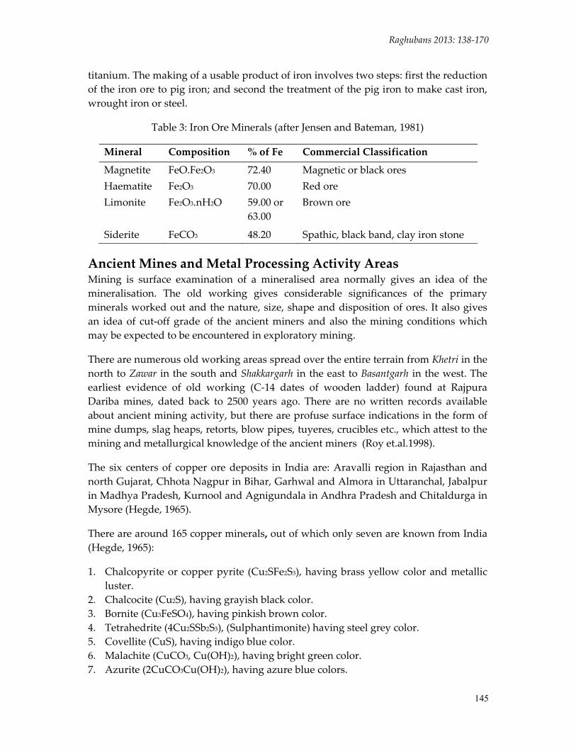
Of, the iron ore minerals, magnetite is the richest but of minor quantity; hematite is the mainstay of the iron industry; limonite and siderite are of importance (Jensen and Bateman, 1981). Other iron bearing minerals, such as pyrite FeS2, pyrohotite Fe1‐xS, marcasite FeS, and chamosite Fe2Al2S1O5(OH)4 do not occur in significant amounts in high grade large deposits and are not considered as potential iron reserves in the

ISSN 2347 – 5463 Heritage: Journal of Multidisciplinary Studies in Archaeology 1: 2013
144
Table 1: Copper Mineral Ores (after Jensen and Bateman, 1981)
Minerals Composition % of Cu
Minerals Composition % of Cu
Native: Copper
Cu
100.00
Native: Copper
Cu
100.00
Sulphides: Chalcopyrite Bornite Chalcocite Covellite Enargite Tetrahedrite Tennantite
CuFeS2 Cu5FeS4 Cu2S Cus Cu3AsS4 Cu8Sb2S7 Cu8As2S7
34.50 63.30 79.80 66.40 48.30 52.10 57.00
Oxidized: Cuprite Tenorite Malachite Azurite Chrysocolla Antlerite Brochantite Atacamite
Cu2O CuO CuCO3Cu(OH)2 2CuCO3Cu(OH)2 CuSiO3..2H2O Cu3SO4(OH)4 Cu4SO4(OH)6 CuCl2.3Cu(OH)2
88.80 79.80 57.30 55.10 36.00 54.00 56.20 59.40
Table 2: Common Gangue Minerals (after Jensen and Batman, 1981)
Class Name Composition Oxides Quartz
Other silica Bauxite, etc Limonite
SiO2 SiO2 Al2O3.2H2O Fe2O3.H2O
Carbonates Calcite Dolomite Siderite Rhodochrosite
CaCO3 (Ca,Mg)Co3 FeCO3 MnCO3
Sulphates Barite Gypsum
BaSO4 CaSO4+2H2O
Silicates Feldspar Garnet Rhodonite Chlorite Clay minerals
MnSiO3
Miscellaneous Rock matter Fluorite Apatite Pyrite Marcasite Pyrrhotite Arsenopyrite
CaF2 (CaF)Ca4(PO4)3 FeS2 FeS2 Fe1‐xS FeAsS
foreseeable future. Common impurities in iron ores are silica, calcium carbonate, phosphorus, manganese (especially in hematite), sulphur, alumina, water and
Raghubans 2013: 138‐170
145
titanium. The making of a usable product of iron involves two steps: first the reduction of the iron ore to pig iron; and second the treatment of the pig iron to make cast iron, wrought iron or steel.
Table 3: Iron Ore Minerals (after Jensen and Bateman, 1981)
Mineral Composition % of Fe Commercial Classification
Magnetite FeO.Fe2O3 72.40 Magnetic or black ores Haematite Fe2O3 70.00 Red ore Limonite Fe2O3.nH2O 59.00 or
63.00 Brown ore
Siderite FeCO3 48.20 Spathic, black band, clay iron stone
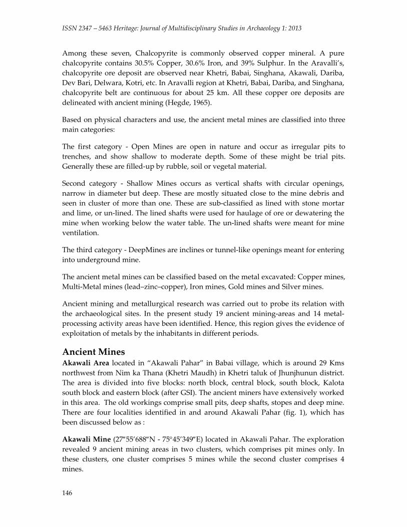
Ancient Mines and Metal Processing Activity Areas Mining is surface examination of a mineralised area normally gives an idea of the mineralisation. The old working gives considerable significances of the primary minerals worked out and the nature, size, shape and disposition of ores. It also gives an idea of cut‐off grade of the ancient miners and also the mining conditions which may be expected to be encountered in exploratory mining.
There are numerous old working areas spread over the entire terrain from Khetri in the north to Zawar in the south and Shakkargarh in the east to Basantgarh in the west. The earliest evidence of old working (C‐14 dates of wooden ladder) found at Rajpura Dariba mines, dated back to 2500 years ago. There are no written records available about ancient mining activity, but there are profuse surface indications in the form of mine dumps, slag heaps, retorts, blow pipes, tuyeres, crucibles etc., which attest to the mining and metallurgical knowledge of the ancient miners (Roy et.al.1998).
The six centers of copper ore deposits in India are: Aravalli region in Rajasthan and north Gujarat, Chhota Nagpur in Bihar, Garhwal and Almora in Uttaranchal, Jabalpur in Madhya Pradesh, Kurnool and Agnigundala in Andhra Pradesh and Chitaldurga in Mysore (Hegde, 1965).
There are around 165 copper minerals, out of which only seven are known from India (Hegde, 1965):
1. Chalcopyrite or copper pyrite (Cu2SFe2S3), having brass yellow color and metallic luster.
2. Chalcocite (Cu2S), having grayish black color. 3. Bornite (Cu3FeSO4), having pinkish brown color. 4. Tetrahedrite (4Cu2SSb2S3), (Sulphantimonite) having steel grey color. 5. Covellite (CuS), having indigo blue color. 6. Malachite (CuCO3, Cu(OH)2), having bright green color. 7. Azurite (2CuCO3Cu(OH)2), having azure blue colors.
ISSN 2347 – 5463 Heritage: Journal of Multidisciplinary Studies in Archaeology 1: 2013
146
Among these seven, Chalcopyrite is commonly observed copper mineral. A pure chalcopyrite contains 30.5% Copper, 30.6% Iron, and 39% Sulphur. In the Aravalli’s, chalcopyrite ore deposit are observed near Khetri, Babai, Singhana, Akawali, Dariba, Dev Bari, Delwara, Kotri, etc. In Aravalli region at Khetri, Babai, Dariba, and Singhana, chalcopyrite belt are continuous for about 25 km. All these copper ore deposits are delineated with ancient mining (Hegde, 1965).
Based on physical characters and use, the ancient metal mines are classified into three main categories:
The first category ‐ Open Mines are open in nature and occur as irregular pits to trenches, and show shallow to moderate depth. Some of these might be trial pits. Generally these are filled‐up by rubble, soil or vegetal material.
Second category ‐ Shallow Mines occurs as vertical shafts with circular openings, narrow in diameter but deep. These are mostly situated close to the mine debris and seen in cluster of more than one. These are sub‐classified as lined with stone mortar and lime, or un‐lined. The lined shafts were used for haulage of ore or dewatering the mine when working below the water table. The un‐lined shafts were meant for mine ventilation.
The third category ‐ DeepMines are inclines or tunnel‐like openings meant for entering into underground mine.
The ancient metal mines can be classified based on the metal excavated: Copper mines, Multi‐Metal mines (lead–zinc–copper), Iron mines, Gold mines and Silver mines.
Ancient mining and metallurgical research was carried out to probe its relation with the archaeological sites. In the present study 19 ancient mining‐areas and 14 metal‐ processing activity areas have been identified. Hence, this region gives the evidence of exploitation of metals by the inhabitants in different periods.
Ancient Mines Akawali Area located in “Akawali Pahar” in Babai village, which is around 29 Kms northwest from Nim ka Thana (Khetri Maudh) in Khetri taluk of Jhunjhunun district. The area is divided into five blocks: north block, central block, south block, Kalota south block and eastern block (after GSI). The ancient miners have extensively worked in this area. The old workings comprise small pits, deep shafts, stopes and deep mine. There are four localities identified in and around Akawali Pahar (fig. 1), which has been discussed below as :
Akawali Mine (27″55’688″N ‐ 75°45’349″E) located in Akawali Pahar. The exploration revealed 9 ancient mining areas in two clusters, which comprises pit mines only. In these clusters, one cluster comprises 5 mines while the second cluster comprises 4 mines.

Raghubans 2013: 138‐170
147
Akawali Mine No 1 (27°55’756″N ‐ 75°45’513″E), which is also located in Akawali Pahar. The mine has identified as ancient mining area comprises small pits, which was extensively work by the ancient miners.
Akawali Mine No 2 (27°55’760″N ‐ 75°45’520″E) located 0.2 km on the top of the Akawali Pahar.The mine identified as deep mine, which was also extensively work by the ancient miners.
Suradhi (SRD) (27°55’961”N – 75°46’625”E) located 2 km northwest in Babai village. The mine identified as open mine.
Samiyo ki Dhani located in Baleshwar village in Nim ka Thana taluka of Sikar district. The village is nearly 13 Kms east from Nim ka Thana (Khetri Maudh). The site has revealed open mine comprises ancient copper mining area.
Beed Ki Dhani (BKD) (27°41’N – 75°54’E) located 1 km northeast of Dariba village in Nim ka Thana taluka of Sikar district. The village is situated 23 Kms southeast of Nim ka Thana (Khetri Maudh) drained by perennial streams with open scrub area having few patches of agricultural field around the site. A multi‐cultural site revealed Mesolithic and Chalcolithic material along with ancient mining comprises open mine, which are around 3 m wide and 15 m deep. The cultural materials were collected from the vicinity of the ancient mining area.
Bavan Kuhi (BVK) (27°44’405″N – 75°29’294″E) located 0.5 km west of the village Dhanota in Udaipurwati taluka of Jhunjhunun district. The village is situated around 40 Kms west from Nim ka Thana (Khetri Maudh). The area drained by ephemeral streams and the landform shows agricultural land on the northern side of the site. The site has revealed ancient mine area comprises open pit mine having 52 open pits along with the drainage channels, which was used to extract water from the pits and narrow shafts lead into big stopes. The mining area is locally known as Bavan Kuhi (fifty two wells). Some of the stopes are more than 35m wide (fig. 2). Dumps containing around 0.2 million tons of slags are lying at places in the Dhanota village (after GSI).
Kakrana (KRN) (27°53’476”N – 75°39’458”E) located 0.5 km north of the village Kakrana in Nim ka Thana taluka of Sikar district. The village is around 22 Kms northwest of Nim ka Thana (Khetri Maudh) drained by Kantli River flowing south to north on the western side of the village. The landform shows number of sand dunes around the site. A multi‐cultural site revealed Mesolithic and Chalcolithic materials. Along with this cultural material, the site has shown open mine, which indicate mining area used by the ancient miners.
Khetri Mine No 1 and 2 (28°04’267”N – 75°48’287”E) located 3 km south towards the village Kharkhara in Khetri taluka of Jhunjhunun district. The village is around 34 Kms northwest from Nim ka Thana (Khetri Maudh). The Khetri mine areas are the part of Khetri copper complex, which extends 3 km by 1 km. The surface manifestations of
ISSN 2347 – 5463 Heritage: Journal of Multidisciplinary Studies in Archaeology 1: 2013
148
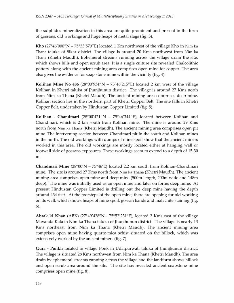
the sulphides mineralization in this area are quite prominent and present in the form of gossans, old workings and huge heaps of metal slags (fig. 3).
Kho (27°46’000”N – 75°33’570”E) located 1 Km northwest of the village Kho in Nim ka Thana taluka of Sikar district. The village is around 20 Kms northwest from Nim ka Thana (Khetri Maudh). Ephemeral streams running across the village drain the site, which shows hills and open scrub area. It is a single culture site revealed Chalcolithic pottery along with the ancient mining area comprises open mine for copper. The area also gives the evidence for soap stone mine within the vicinity (fig. 4).
Kolihan Mine No 486 (28°00’934”N – 75°46’215”E) located 2 km west of the village Kolihan in Khetri taluka of Jhunjhunun district. The village is around 27 Kms north from Nim ka Thana (Khetri Maudh). The ancient mining area comprises deep mine. Kolihan section lies in the northern part of Khetri Copper Belt. The site falls in Khetri Copper Belt, undertaken by Hindustan Copper Limited (fig. 5).
Kolihan ‐ Chandmari (28°00’421”N – 75°46’344”E), located between Kolihan and Chandmari, which is 2 km south from Kolihan mine. The mine is around 29 Kms north from Nim ka Thana (Khetri Maudh). The ancient mining area comprises open pit mine. The intervening section between Chandmari pit in the south and Kolihan mines in the north. The old workings with dumps of mine spoil show that the ancient miners worked in this area. The old workings are mostly located either at hanging wall or footwall side of gossans exposures. These workings seem to extend to a depth of 15‐30 m.
Chandmari Mine (28″00’N – 75°46’E) located 2.2 km south from Kolihan‐Chandmari mine. The site is around 27 Kms north from Nim ka Thana (Khetri Maudh). The ancient mining area comprises open mine and deep mine (500m length, 200m wide and 148m deep). The mine was initially used as an open mine and later on forms deep mine. At present Hindustan Copper Limited is drilling out the deep mine having the depth around 434 feet. At the footsteps of the open mine, there are opening for old working on its wall, which shows heaps of mine spoil, gossan bands and malachite staining (fig. 6).
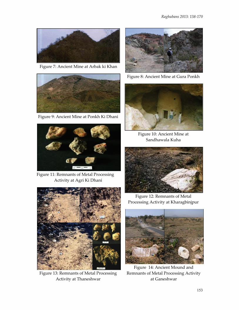
Abrak ki Khan (ABK) (27°49’428″N ‐ 75°52’231″E), located 2 Kms east of the village Mavanda Kala in Nim ka Thana taluka of Jhunjhunun district. The village is nearly 13 Kms northeast from Nim ka Thana (Khetri Maudh). The ancient mining area comprises open mine having quartz‐mica schist situated on the hillock, which was extensively worked by the ancient miners (fig. 7).
Gura ‐ Ponkh located in village Ponk in Udaipurwati taluka of Jhunjhunun district. The village is situated 28 Kms northwest from Nim ka Thana (Khetri Maudh). The area drain by ephemeral streams running across the village and the landform shows hillock and open scrub area around the site. The site has revealed ancient soapstone mine comprises open mine (fig. 8).

Raghubans 2013: 138‐170
149
Ponkh ki Dhani (27°49’109”N – 75°35’937”E) located in the village Ponk in Udaipurwatitaluka of Jhunjhunun district. The village is round 28 Kms northwest from Nim ka Thana (Khetri Maudh). The ancient mining area comprises open mine (fig. 9).
Sandhawala Kuha (SWK) (27°48’N – 75°35’”E) located 0.5 Kms southwest of the village Ponk in Udaipurwatitaluka of Jhunjhunun district. The village is around 28 Kms northwest from Nim ka Thana (Khetri Maudh). The site revealed ancient mining area comprises open mine (fig. 10).
Sawalpur (SWP) (27°38’N – 75°05’E) located 2 km east at the vicinity of the village Sawalpur in Nim ka Thana taluka of Sikar district. The village is around 30 Kms southeast from Nim ka Thana (Khetri Maudh). The area drain by Buchara Bandh located 3 km on the north and 2.5 km on the south of the village. The ancient mining area comprises open pit mines having quartzite‐mica minerals.
Metal Processing Activity Areas Agri Ki Dhani (AKD) (27°39”441″N ‐ 75°50’779″E) located on the eastern periphery of the village Agri Ki Dhani in Nim ka Thana taluka of Sikar district. The village is nearly 15 Kms southeast from Nim ka Thana (Khetri Maudh). The area drain by seasonal Bani or Khad ki nalla on the northern side of the slope and the landform shows hillock around the site. The site identified as a metal processing activity areacomprises the findings of vitrified clay lumps, metallurgical slags, terracotta tuyeres and unidentified sherds collected from the slope of the hillock. There are also patches of slag deposits on the slope of the hillock (fig. 11).
Baleshwar (BLW) (27°43’316″N – 75°53’418″E) located 1 km southwest of the village Baleshwar in Nim ka Thana taluka of Sikar district. The village is also nearly 13 Kms east from Nim ka Thana (Khetri Maudh). The area drain by perennial streams running down from the hillock and the landform shows dense and open scrub area. The site identified as a metal processing activity area comprises metallurgical slags spread on slope of the hillock.
Kharagbinjpur (KBP) (27°43’156”N – 75°53’319”E) located 0.5 Km northwest of the village Baleshwar in Nim ka Thana taluka of Sikar district. A deserted village as a pilgrim place situated 14 Kms northwest from Nim ka Thana (Khetri Maudh). Perennial streams running down from the hills drain the area. The dense and open scrub areas with deserted look give picturesque view to the place. It is a single culture site. Along with Chalcolithic material the site also identified as a metal processing activity area with comprises the findings of vitrified clay lumps and metallurgical slags collected from the slope of the hillock. The site is located on the foothills in the open scrub area of about 1 Km along with the structural remains and slag deposits. The huge slag deposit scattered on the surface indicates that the area was extensively used for metal producing (fig. 12).
ISSN 2347 – 5463 Heritage: Journal of Multidisciplinary Studies in Archaeology 1: 2013
150
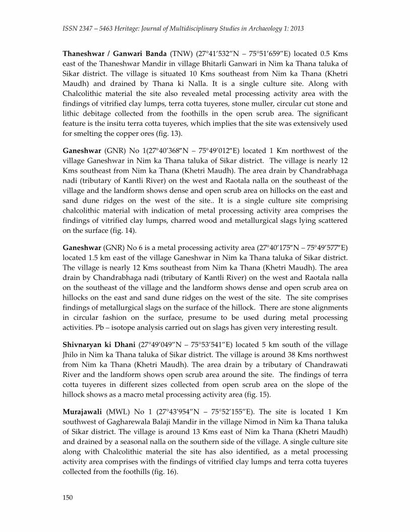
Thaneshwar / Ganwari Banda (TNW) (27°41’532”N – 75°51’659”E) located 0.5 Kms east of the Thaneshwar Mandir in village Bhitarli Ganwari in Nim ka Thana taluka of Sikar district. The village is situated 10 Kms southeast from Nim ka Thana (Khetri Maudh) and drained by Thana ki Nalla. It is a single culture site. Along with Chalcolithic material the site also revealed metal processing activity area with the findings of vitrified clay lumps, terra cotta tuyeres, stone muller, circular cut stone and lithic debitage collected from the foothills in the open scrub area. The significant feature is the insitu terra cotta tuyeres, which implies that the site was extensively used for smelting the copper ores (fig. 13).
Ganeshwar (GNR) No 1(27°40’368″N – 75°49’012″E) located 1 Km northwest of the village Ganeshwar in Nim ka Thana taluka of Sikar district. The village is nearly 12 Kms southeast from Nim ka Thana (Khetri Maudh). The area drain by Chandrabhaga nadi (tributary of Kantli River) on the west and Raotala nalla on the southeast of the village and the landform shows dense and open scrub area on hillocks on the east and sand dune ridges on the west of the site.. It is a single culture site comprising chalcolithic material with indication of metal processing activity area comprises the findings of vitrified clay lumps, charred wood and metallurgical slags lying scattered on the surface (fig. 14).
Ganeshwar (GNR) No 6 is a metal processing activity area (27°40’175″N – 75°49’577″E) located 1.5 km east of the village Ganeshwar in Nim ka Thana taluka of Sikar district. The village is nearly 12 Kms southeast from Nim ka Thana (Khetri Maudh). The area drain by Chandrabhaga nadi (tributary of Kantli River) on the west and Raotala nalla on the southeast of the village and the landform shows dense and open scrub area on hillocks on the east and sand dune ridges on the west of the site. The site comprises findings of metallurgical slags on the surface of the hillock. There are stone alignments in circular fashion on the surface, presume to be used during metal processing activities. Pb – isotope analysis carried out on slags has given very interesting result.
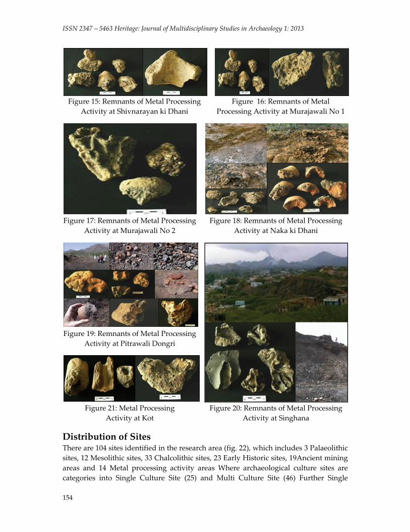
Shivnaryan ki Dhani (27°49’049”N – 75°53’541”E) located 5 km south of the village Jhilo in Nim ka Thana taluka of Sikar district. The village is around 38 Kms northwest from Nim ka Thana (Khetri Maudh). The area drain by a tributary of Chandrawati River and the landform shows open scrub area around the site. The findings of terra cotta tuyeres in different sizes collected from open scrub area on the slope of the hillock shows as a macro metal processing activity area (fig. 15).
Murajawali (MWL) No 1 (27°43’954”N – 75°52’155”E). The site is located 1 Km southwest of Gagharewala Balaji Mandir in the village Nimod in Nim ka Thana taluka of Sikar district. The village is around 13 Kms east of Nim ka Thana (Khetri Maudh) and drained by a seasonal nalla on the southern side of the village. A single culture site along with Chalcolithic material the site has also identified, as a metal processing activity area comprises with the findings of vitrified clay lumps and terra cotta tuyeres collected from the foothills (fig. 16).
Raghubans 2013: 138‐170
151
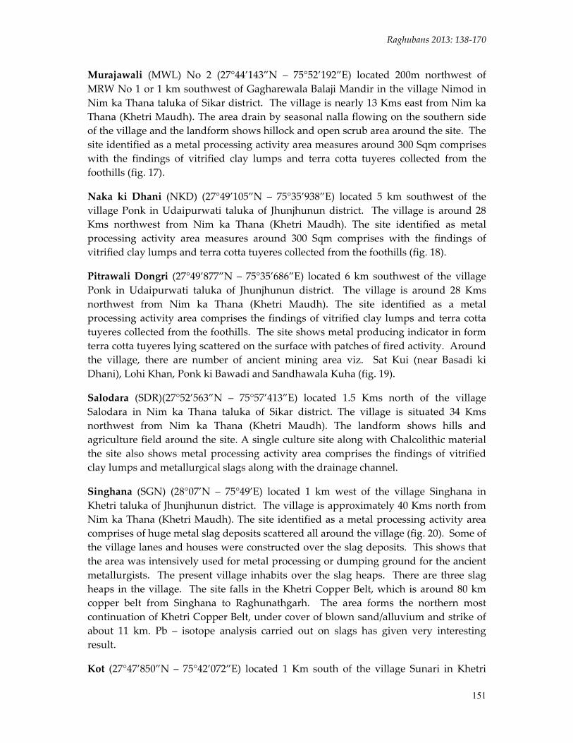
Murajawali (MWL) No 2 (27°44’143”N – 75°52’192”E) located 200m northwest of MRW No 1 or 1 km southwest of Gagharewala Balaji Mandir in the village Nimod in Nim ka Thana taluka of Sikar district. The village is nearly 13 Kms east from Nim ka Thana (Khetri Maudh). The area drain by seasonal nalla flowing on the southern side of the village and the landform shows hillock and open scrub area around the site. The site identified as a metal processing activity area measures around 300 Sqm comprises with the findings of vitrified clay lumps and terra cotta tuyeres collected from the foothills (fig. 17).
Naka ki Dhani (NKD) (27°49’105”N – 75°35’938”E) located 5 km southwest of the village Ponk in Udaipurwati taluka of Jhunjhunun district. The village is around 28 Kms northwest from Nim ka Thana (Khetri Maudh). The site identified as metal processing activity area measures around 300 Sqm comprises with the findings of vitrified clay lumps and terra cotta tuyeres collected from the foothills (fig. 18).
Pitrawali Dongri (27°49’877”N – 75°35’686”E) located 6 km southwest of the village Ponk in Udaipurwati taluka of Jhunjhunun district. The village is around 28 Kms northwest from Nim ka Thana (Khetri Maudh). The site identified as a metal processing activity area comprises the findings of vitrified clay lumps and terra cotta tuyeres collected from the foothills. The site shows metal producing indicator in form terra cotta tuyeres lying scattered on the surface with patches of fired activity. Around the village, there are number of ancient mining area viz. Sat Kui (near Basadi ki Dhani), Lohi Khan, Ponk ki Bawadi and Sandhawala Kuha (fig. 19).
Salodara (SDR)(27°52’563”N – 75°57’413”E) located 1.5 Kms north of the village Salodara in Nim ka Thana taluka of Sikar district. The village is situated 34 Kms northwest from Nim ka Thana (Khetri Maudh). The landform shows hills and agriculture field around the site. A single culture site along with Chalcolithic material the site also shows metal processing activity area comprises the findings of vitrified clay lumps and metallurgical slags along with the drainage channel.
Singhana (SGN) (28°07’N – 75°49’E) located 1 km west of the village Singhana in Khetri taluka of Jhunjhunun district. The village is approximately 40 Kms north from Nim ka Thana (Khetri Maudh). The site identified as a metal processing activity area comprises of huge metal slag deposits scattered all around the village (fig. 20). Some of the village lanes and houses were constructed over the slag deposits. This shows that the area was intensively used for metal processing or dumping ground for the ancient metallurgists. The present village inhabits over the slag heaps. There are three slag heaps in the village. The site falls in the Khetri Copper Belt, which is around 80 km copper belt from Singhana to Raghunathgarh. The area forms the northern most continuation of Khetri Copper Belt, under cover of blown sand/alluvium and strike of about 11 km. Pb – isotope analysis carried out on slags has given very interesting result.
Kot (27°47’850”N – 75°42’072”E) located 1 Km south of the village Sunari in Khetri

ISSN 2347 – 5463 Heritage: Journal of Multidisciplinary Studies in Archaeology 1: 2013
152
taluka of Jhunjhunun district. The village is situated around 15 Kms northwest from Nim ka Thana (Khetri Maudh). The site is located on the bed of Kantli River, which flows from south to north in the research area. It is a multi‐cultural site revealed Chalcolithic, Early Historic – I and Early Historic – II materials. Along with this, it also identified, as metal processing activity area comprises tuyeres and vitrified clay lumps (fig. 21).
Figure 2: Ancient Mine at Bavan Kuhi
Figure 3: Ancient Mine, Khetri Mine No 1 and 2
Figure 1: Ancient Mine at Akawali Area
Figure 4: Ancient Mine at Kho
Figure 5: Ancient Mine at Kolihan, Mine No 486 Figure 6: Ancient Mine at Chandmari
Raghubans 2013: 138‐170
153
Figure 7: Ancient Mine at Arbak ki Khan
Figure 8: Ancient Mine at Gura Ponkh
Figure 9: Ancient Mine at Ponkh Ki Dhani
Figure 10: Ancient Mine at Sandhawala Kuha
Figure 11: Remnants of Metal Processing Activity at Agri Ki Dhani
Figure 12: Remnants of Metal Processing Activity at Kharagbinjpur
Figure 14: Ancient Mound and Remnants of Metal Processing Activity
at Ganeshwar Figure 13: Remnants of Metal Processing
Activity at Thaneshwar
ISSN 2347 – 5463 Heritage: Journal of Multidisciplinary Studies in Archaeology 1: 2013
154
Figure 15: Remnants of Metal Processing Activity at Shivnarayan ki Dhani
Figure 16: Remnants of Metal Processing Activity at Murajawali No 1
Figure 17: Remnants of Metal Processing Activity at Murajawali No 2
Figure 18: Remnants of Metal Processing Activity at Naka ki Dhani
Figure 19: Remnants of Metal Processing Activity at Pitrawali Dongri
Figure 21: Metal Processing Activity at Kot
Figure 20: Remnants of Metal Processing Activity at Singhana
Distribution of Sites There are 104 sites identified in the research area (fig. 22), which includes 3 Palaeolithic sites, 12 Mesolithic sites, 33 Chalcolithic sites, 23 Early Historic sites, 19Ancient mining areas and 14 Metal processing activity areas Where archaeological culture sites are categories into Single Culture Site (25) and Multi Culture Site (46) Further Single
Raghubans 2013: 138‐170
155
Culture Site classified into – Palaeolithic (2), Mesolithic (3), Chalcolithic (15) and Early Historic (5). Whereas in Multi Culture Site – Palaeolithic (1), Mesolithic (9), Chalcolithic (18) and Early Historic (18).
Distribution of Sites in Geological Settings There are four geological deposits were identified (fig. 23, graph 1):
Deposit 1 ‐ sand, alluvium etc. covers around 6.41% of the research area and no sites have been found in this deposit.
Deposit 2 ‐ schist, gneisses, calc‐gneisses, dolmitic marble, amphibiolite and phyllite, which covers around 24.22% of the research area and around 42.71% of sites were found. Out of which Palaeolithic (1) 0.97%, Mesolithic (5) 4.85%, Chalcolithic (14) 13.59%, Early Historic (11) 10.76%, Ancient Mining Areas (10) 9.70% and Metal Processing Activity Areas (3) 2.91%
Deposit 3 ‐ intrusive and extrusive rocks covers around 0.96% of the research area and here also no sites have been found in this deposit.
Deposit 4 ‐ quartz, schist and conglomerate, which covers around 68.41% of the research area and around 57.28% of sites were found. Out of which Palaeolithic (2) 1.97%, Mesolithic (7) 6.79%, Chalcolithic (19) 18.44%, Early Historic (12) 11.65%, Ancient Mining Areas (8) 7.76% and Metal Processing Activity Areas (11) 10.67%.
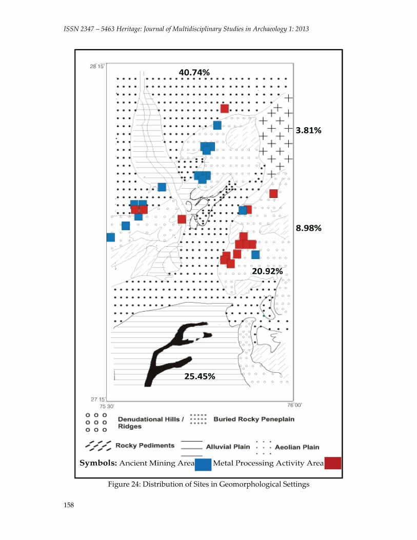
Distribution of Sites in Geomorphological Settings There are five geomorphic features were identified (fig. 24, graph 2):
Denudational Hills / Ridges – covers around 20.92% of the area. Around 49.49% of sites were found. Out of which Palaeolithic (3) 2.91%, Mesolithic (2) 1.94%, Chalcolithic (14) 13.59%, Early Historic (10) 9.70%, Ancient Mining Areas (13) 12.62% and Metal Processing Activity Areas (9) 8.73%.
Rocky Pediments – covers around 8.98% of the area. Around 10.67% of sites were found. Out of which Mesolithic (2) 1.94%, Chalcolithic (5) 4.85% and Early Historic (4) 3.88%.
Alluvial Plain – covers around 25.45% of the area. Around 7.76% of sites were found. Out of which Mesolithic (2) 1.94%, Chalcolithic (3) 2.91%, Early Historic (2) 1.94% and Ancient Mining Areas (1) 0.97%.
Aeolian Plain – covers around 40.74% of the area. Around 32.01% of sites were found. Out of which Mesolithic (6) 5.82%, Chalcolithic (11) 10.67%, Early Historic (7) 6.79%, Ancient Mining Areas (4) 3.88% and Metal Processing Activity Areas (5) 4.85%.
Buried Rocky Peneplain – covers around 3.81 % of the research area and there are no sites found in this feature.

ISSN 2347 – 5463 Heritage: Journal of Multidisciplinary Studies in Archaeology 1: 2013
156
Figure 22: Distributions of Sites in Research Area

Raghubans 2013: 138‐170
157
Figure 23: Distribution of Sites in Geological Settings
ISSN 2347 – 5463 Heritage: Journal of Multidisciplinary Studies in Archaeology 1: 2013
158
Figure 24: Distribution of Sites in Geomorphological Settings

Raghubans 2013: 138‐170
159
Figure 25: Distribution of Sites in Dune Types

ISSN 2347 – 5463 Heritage: Journal of Multidisciplinary Studies in Archaeology 1: 2013
160
Figure 26: Distribution of Sites in Drainage System

Raghubans 2013: 138‐170
161
Graph 1: Number of Sites in Geological Settings
Graph 2: Number of Sites in Geomorphological Settings
Graph 3: Number of Sites in Dune Types

ISSN 2347 – 5463 Heritage: Journal of Multidisciplinary Studies in Archaeology 1: 2013
162
Distribution of Sites in Dune Types There are six types of dunes have been noticed (fig. 25, graph 3):
Sand Sheets / Mounds ‐ covers around 16.23 % of the area. Around 21.34% of sites were found. Out of which Mesolithic (2) 1.94%, Chalcolithic (7) 6.79%, Early Historic (5) 4.85%%, Ancient Mining Areas (6) 5.82%% and Metal Processing Activity Areas (2) 1.94%.
Rocky Peneplains – covers around 29.16 % of the area. Around 30.08% of sites were found. Out of which Mesolithic (3) 2.91%, Chalcolithic (15) 14.56%, Early Historic (6) 5.82%, Ancient Mining Areas (1) 0.97% and Metal Processing Activity Areas (6) 5.82%.
Hills / Rocky ridges – covers around 20.19 % of the area. Around 48.51% of sites were found. Out of which Palaeolithic (3) 2.91%, Mesolithic (7) 6.79%, Chalcolithic (11) 10.67%, Early Historic (12) 11.65%, Ancient Mining Areas (11) 10.67% and Metal Processing Activity Areas (6) 5.82%.
Transverse Dunes – covers around 13.82 % of the research area and there are no sites found in this feature.
Alluvial Plain ‐ covers 18.94 % of the research area and no sites have been found.
Sand Sheets and Longitudinal Dunes – covers around 1.63 % of the research area and there also no sites have been found.
Distribution of Sites in Drainage System The present drainage system in research area is supported by Kantli, Rupangarh, Dohan, Dongar, Sabi (Sahibi), Chandrawati, Udaipur‐Lohargarh ki Nadi, Madhobini Nadi, Sota Nadi, Dhudhala Nadi, Bandi Nadi, Sukh Nadi (Singhana Nadi), and Khariya Nadi. It is observed in the research area that archaeological sites are located on the small streams and nallas rather than on the main rivers and their tributaries. This imply that people have preferred water bodies where water is stored for longer period than the rivers and their tributaries where water is available seasonally (fig. 26).
Conclusion The present study enunciates the position of ancient mining and metal‐processing activities in the Shekhawati region.The research brings forth the structure‐inference concerning location, function, distribution and trend at regional scale with a view to understand ecological adaptation and cultural changes through time. The ancient mining and metal‐processing activities was carried out to probe its relation with the archaeological sites. In the present study 19 ancient mining‐areas and 14 metal‐processing activity areas have been identified from the research area. Hence, this region gives ample of evidence of exploitation of metals by the inhabitants in different periods. Most of the mining and metal processing activities have been found on the denudational hills and rocky ridges and few have been scattered on the aeolian plains.
Raghubans 2013: 138‐170
163
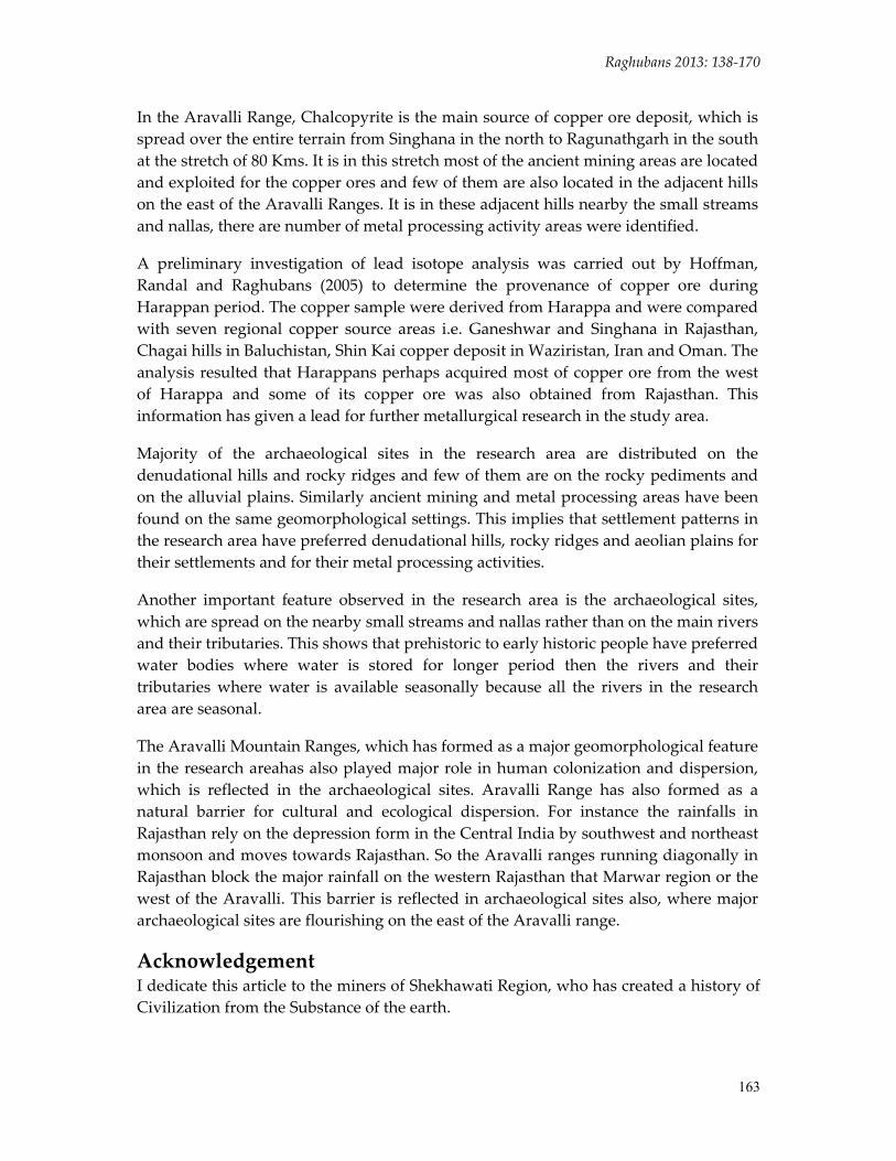
In the Aravalli Range, Chalcopyrite is the main source of copper ore deposit, which is spread over the entire terrain from Singhana in the north to Ragunathgarh in the south at the stretch of 80 Kms. It is in this stretch most of the ancient mining areas are located and exploited for the copper ores and few of them are also located in the adjacent hills on the east of the Aravalli Ranges. It is in these adjacent hills nearby the small streams and nallas, there are number of metal processing activity areas were identified.
A preliminary investigation of lead isotope analysis was carried out by Hoffman, Randal and Raghubans (2005) to determine the provenance of copper ore during Harappan period. The copper sample were derived from Harappa and were compared with seven regional copper source areas i.e. Ganeshwar and Singhana in Rajasthan, Chagai hills in Baluchistan, Shin Kai copper deposit in Waziristan, Iran and Oman. The analysis resulted that Harappans perhaps acquired most of copper ore from the west of Harappa and some of its copper ore was also obtained from Rajasthan. This information has given a lead for further metallurgical research in the study area.
Majority of the archaeological sites in the research area are distributed on the denudational hills and rocky ridges and few of them are on the rocky pediments and on the alluvial plains. Similarly ancient mining and metal processing areas have been found on the same geomorphological settings. This implies that settlement patterns in the research area have preferred denudational hills, rocky ridges and aeolian plains for their settlements and for their metal processing activities.
Another important feature observed in the research area is the archaeological sites, which are spread on the nearby small streams and nallas rather than on the main rivers and their tributaries. This shows that prehistoric to early historic people have preferred water bodies where water is stored for longer period then the rivers and their tributaries where water is available seasonally because all the rivers in the research area are seasonal.
The Aravalli Mountain Ranges, which has formed as a major geomorphological feature in the research areahas also played major role in human colonization and dispersion, which is reflected in the archaeological sites. Aravalli Range has also formed as a natural barrier for cultural and ecological dispersion. For instance the rainfalls in Rajasthan rely on the depression form in the Central India by southwest and northeast monsoon and moves towards Rajasthan. So the Aravalli ranges running diagonally in Rajasthan block the major rainfall on the western Rajasthan that Marwar region or the west of the Aravalli. This barrier is reflected in archaeological sites also, where major archaeological sites are flourishing on the east of the Aravalli range.
Acknowledgement I dedicate this article to the miners of Shekhawati Region, who has created a history of Civilization from the Substance of the earth.
ISSN 2347 – 5463 Heritage: Journal of Multidisciplinary Studies in Archaeology 1: 2013
164
References Agarwal, B.D. 1978. Rajasthan District Gazetteers, Sikar. Directorate of District Gazetteers,
Government of Rajasthan, Jaipur. Agrawal, D.P. 1971. The Copper Bronze of India. New Delhi: Munishiram Manoharlal. Agrawal, D.P. 1982. The Archaeology of India. Scandinavian Institute of Asian Studies
Monograph Series 40. Curzon Press. London. Agrawala, R.C. 1979. More Copper finds from Rajasthan, Man and Environment III: 91‐
92. Agrawala, R.C. 1978. Archaeological Discoveries at Ganeshwar, Rajasthan.
Archaeological Studies 3. Mysore. Agrawala, R.C. 1981a. Protohistoric Copper Objects from Rajasthan: New Parameters.
V.S. Srivastava (Ed). Cultural Contours of India: 25‐31. New Delhi. Agrawala, R.C. 1981b. Recent Explorations in Rajasthan. Man and Environment V. Agrawala, R.C. 1984. Ganeshwar Culture: A Review. Journal of Oriental Research Institute
Baroda 34(1‐2): 89‐95. Agrawala, R.C. and V. Kumar. 1982. Ganeshwar – Jodhpur Culture. A New Trait in
Indian Archaeology. G.L. Possehl (Ed.). Harappan Civilization. A Contemporary Perspective. pp. 125 – 134. New Delhi: Oxford IBH. 1982.
Allchin, B. and Allchin, R. 1982. The Rise of Civilization in India and Pakistan. Cambridge: Cambridge University Press.
Allchin, B., A. Goudie and K.T.M. Hegde. 1978. The Prehistory and Paleography of the Great Indian Desert. Academic Press: London.
Antonava, K., G. Bongard‐Levin and G. Kotovsky. 1979. A History of India. Book: 1. Progress Publication. Moscow.
Asthana, S. 1982. Harappan Trade in Metals and Minerals – A Regional Approach. G.L. Possehl (Ed). Harappan Civilization – A Contemporary Perspective. New Delhi: Oxford IBH. 1982.
Bachmann, H.G. 1982. The Identification of Slags from Archaeological Sites. Institute of Archaeology, London.
Bailey, A.R. 1964. A Text Book of Metallurgy. London Bala, M. 1997. Some Unique Antiquities And Pottery From Kalibangan. J. P. Joshi (Ed).
Facets of Indian Civilization. Recent Perspective. Vol. 1. Aryan Books International. New Delhi.
Ball, V. 1881. A Manual of Geology of India. Part: 3.Economic Geology. GSI. Calcutta. Barnes, J.W. and E.H. Bailey. 1972. Geologists Discover Ancient Retort Evidence Points
to Worlds Oldest Mine. World Mining. pp. 49‐55. Bhan, K.K. 1989. Late Harappan Settlement of Western India with specific reference to
Gujarat. J.M. Kenoyer (Ed). Old Problem and New Perspective in the Archaeology of South Asia. Wisconsin.
Bhan, K.K., N. Mehta and K. Krishnan. 1999. A Preliminary Ethno‐archaeological Study of Copper/Brass Working in Rajasthan, Western India. Man and Environment.

Raghubans 2013: 138‐170
165
Bhan, S. 1967. New Light in the OCP. Research Bulletin (Arts) LVII (III). Punjab University. Chandigarh.
Bhandarkar, R.D. 1920. The Archaeological Remains and Excavations at Nagari, Memoirs of the Archaeological Survey of India 4. Calcutta: Superintendent Govt. Printing.
Bhattacharya, D.K. 1996. An Outline of Indian Prehistory. Palaka Prakashan. Delhi. Bhowmik, S.K. 1972. Early Copper and Bronze Technology of Gujarat (Unpublished PhD
Thesis). Vadodara: M. S. University of Baroda. Carlleyle, A.C.L. 1878. Report of a Tour in Eastern Rajputana in 1871‐72 and 1972‐73,
Archaeological Survey of India Report VI: 107‐108, 160‐161. Casal, J. 1961. Fouilles de Mundigak. 2 Vols. Paris: Memoires de la Delegation
Archaeologiquw Francais en Afghanistan, Tome – 17. Chakarbati, D. 1986. The Pre – Industrial Mines of India. Puratattava 16. pp. 65‐72. Chakarbati, D. and N. Lahiri. 1996. Copper and Its Alloys in Ancient India. Palaka
Prakashan. Delhi. Chibber. H.L. 1925. Old Copper Slag’s from Ambamata and Kumbaria in Danta State.
Proceedings of the Indian Science Congress. 12th Session. Coghlan, S. and L. Constantini. 1951. Notes on the Prehistoric Metallurgy of Copper
and Bronze in the Old World. Occasional Papers on Technology 4. Oxford. Pitt River Museum.
Craddock and M.J. Hughes. On Furnaces and Smelting Technology in Antiquity. pp. 59‐70. British Museum Occasional.
Craddock, P.T. 1995. Early Metal Mining and Production. Edinburgh: Uni. Press. Craddock, P.T., L.K. Gurjar, and K.T.M. Hegde. 1983. Zinc Production in Medieval
India. World Archaeology: 211‐221. Cunningham, A. 1873. Bairat, or Vairat in Archaeological Report, 1964‐65, pp. 242‐49.
Calcutta: Archaeological Survey of India. Dalal, K.F. 1980. A Short History of Archaeological Explorations in Bikaner and
Bahawalpur along the ‘Lost’ Saraswati River. Indica 17 (1): 1‐40. Dales, G.F. and Kenoyer, J.M. 1986. Excavation at Mohenjo Daro, Pakistan: the Pottery.
University Museum Press. Phildalphia. Deotare, B.C., M.D. Kajale, A.A. Kshirsagar and S.N. Rajaguru. 1998. Geoarchaeological
and Palaeoenvironmental Studies around Bap‐Malar Playa, District Jodhpur, Rajasthan, Current Science 75 (3): 316‐320.
Deotare, B.C., M.D. Kajale, S.N. Rajaguru, S.Kusumgar, A.J.T. Jull and J.D. Donahue. 2004. Palaeoenvironmental History of Bap‐Malar and Kanod Playas of Western Rajasthan, Thar Desert, Proceedings of the Indian Academy of Sciences (Earth and Planet. Sci): 113(3): 403‐425.
Dhavalikar, M.K. 1984a. Towards an Ecological Model for the Chalcolithic Cultures of Central India and Western India. Journal of Anthropological Archaeology 3: 133‐58.

ISSN 2347 – 5463 Heritage: Journal of Multidisciplinary Studies in Archaeology 1: 2013
166
Dhavalikar, M.K. 1984b. Sub‐Indus Cultures of Central and Western India. Mortimer Wheeler commemoration Volume Frontiers of the Indus Civilization. B.B. Lal and S.P. Gupta (Eds). New Delhi. Books and Books.
Dikshit, K.N. 1984. Late Harappan in Northern India. The Cultural Evolution of Civilization. G.L. Possehl (Ed). Ancient Cities of the Indus. New Delhi. Vikas Pub. House.
Francfort, H.P. 1984. Evidence for Harappan Irrigation System in Haryana and Rajasthan. The Eastern Anthropologist 45.
Gangadhar, K. 1996. Morpho‐Tectonic and Hydrogeological Studies of the Upper Luni and Kantli River Basins, Western Rajasthan (Unpublished Thesis). Department of Geology. M.S. University of Baroda.
Gaur, R.C. 1973. The Ochre Coloured Pottery: A Reassessment of The Evidence. J. E. Vanlohuizen‐Deleeuw and J. M. M. Ubaghs (Eds). South Asian Archaeology 1973.
Gosh, A. 1989. An Encyclopedia of India Archaeology. Vol. 1 and 2. Munshiram Manoharlal Pub. Delhi.
Gupta, S. 1984. Rajasthan District Gazetteers, Jhunjhunun. Directorate of District Gazetteers, Government of Rajasthan, Jaipur.
Handa, D. 1968. Harappan, OCP, and Copper Hoards. G. Tucci (Ed). East and West IsMEO. New Series, Vol. 18 #s 1‐2. March‐June 1968.
Hanna, R. 1959. Rang Mahal. The Swedish Archaeological Expedition to India 1952‐54. Acta Archaeological Lundensia. Series 4 (3). CWK. Gleerup Publisher Lund Sweden.
Hegde, K.T.M. 1991. An Introduction to Ancient Indian Metallurgy. Geological Society of India. Bangalore.
Hegde, K.T.M. and J.E. Ericson. 1985. Ancient Indian Copper Smelting Furnaces. P.T. Ctaddock and M.J. Hughes (Eds.). Furnaces and Smelting Technology in Antiquity. British Museum Occasional Paper No. 48. London: British Museum Research Laboratory pp. 59 – 70.
Hegde, K.T.M. 1965. Technical Studies in Chalcolithic Period Copper Metallurgy (Unpublished PhD Thesis). Vadodara: M. S. University of Baroda.
Hoffman, B., R. Law and K. Raghubans. 2005. Pb isotope analysis to determine the provenance of copper ore during Harappan period. Paper presented in South Asian Archaeological Conference, London.
Hooja, R. 1988. The Ahar Culture And Beyond. Oxford: British Archaeological Review International Series 412.
Hooja, R. and Vijay Kumar. 1995. Aspects of the Early Copper Age in Rajasthan. B.Allchin (Ed.). South Asian Archaeology 1995.
Imperial Gazetteer of India. 1909. Bombay Presidency II. Calcutta. Government of India.
Indian Archaeology: A Review. 1953‐54:37. Delhi: ASI. Indian Archaeology: A Review. 1954‐55: 58. Delhi: ASI. Indian Archaeology: A Review. 1956‐57: 5‐8. Delhi: ASI.

Raghubans 2013: 138‐170
167
Indian Archaeology: A Review. 1959‐60. 13‐14. Excavation at Gilund. Delhi: ASI. Indian Archaeology: A Review. 1960‐61: 13 Delhi: ASI. Indian Archaeology: A Review. 1962‐63: 19‐31. Delhi: ASI. Indian Archaeology: A Review. 1963‐64: 28‐29. Delhi: ASI. Indian Archaeology: A Review. 1972‐73. Excavation at Jodhpura (Rajasthan). Delhi: ASI. Indian Archaeology: A Review. 1972‐73: 29. Delhi: ASI. Indian Archaeology: A Review. 1980‐81. Excavation at Sunari. Delhi: ASI Indian Archaeology: A Review. 1983‐84. Excavation at Ganeshwar District Sikar 71‐72.
Delhi: ASI. Indian Archaeology: A Review. 1993‐94: 93‐97. Delhi: ASI. Jain, K.C. 1972. Ancient Cities and Towns of Rajasthan (A Study of Culture And Civilization).
Motilal Banarsidas. Delhi. Jarrige, J. 1982. Excavation at Mehrgarh: Their Significance for Understanding the
background of the Harappan Civilization. G. L. Possehl (Ed.). Harappan Civilization: A Contemporary Perspective. Delhi: Oxford and IBH and the American Institute of Indian Studies: 79 – 84.
Jarrige, J.F. 1984. Chronology of the earliest periods of the Greater Indus as seen from Mehrgarh, Pakistan. B. Allchin (Ed). South Asian Archaeology 1981. Cambridge: Cambridge University Press. Pp. 21 – 28.
Jensen, M and Bateman, A. 1981. Economic Mineral Deposits. Third Edition. John Wiley and Sons. New York Chichester Brisbane Toronto.
Joshi, J.P., Madhu Bala, and Jassu Ram. 1984. The Indus Civilization: A Reconsideration on the Basis of Distribution Maps, B.B. Lal and S.P. Gupta (Eds.). Frontiers of the Indus Civilization: Sir Mortimer Wheeler Commemoration Volume, pp. 511‐530. New Delhi: Books and Books.
Kennedy, K.A.R and P. Caldwell. 1984 South Asain Prehistoric Human Skeltal Remains and Burial Practices. J. R. Lukacs, (ed.), The People of South Asia: The Biological Anthropology of India, Pakistan and Nepal. 159‐97. New York: Plenum Press.
Kenoyer, J.M. 1991. The Indus Valley Tradition of Pakistan and Western India. Journal of World Prehistory 5(4): 331‐385.
Kenoyer, J.M. and H.M. Miller. 1995. Metal Technology of Indus Valley Tradition in Pakistan and Western India. Ancient Metallurgy of the Asian Old World. University Museum Monograph 89. V. Piggot (Ed.). The University Museum Philadelphia.
Kercross, D. 1950. Ancient Mines and Miners of India. Indian Minerals 4 pp. 5‐10. Lahiri, N. 1992. The Archaeology of Indian Trade Routed up to C. 200 B.C. (Resources Use,
Resources Access, and Lines of Communication). Delhi. Oxford University Press.
Lahiri, N. 1995. Indian Metal and Metals Related Artifacts As Cultural Signifiers. An Ethno‐Archaeological Perspective. World Archaeology 27(10) pp.116‐132.
Lal, B.B. 1958. Birbhanpur: A Microlithic Site in the Damodar Valley, West Bengal. Ancient India 14: 4‐48.
ISSN 2347 – 5463 Heritage: Journal of Multidisciplinary Studies in Archaeology 1: 2013
168
Lal, B.B. 1979. Kalibangan and Indus Civilization. D.P. Agrawal and D. Chakarbati (Eds.). Essays in Indian Protohistory. New Delhi.
Lal, B.B. 1997. The Earliest Civilization of South Asia. Aryan Book International. New Delhi.
Leshnik, L. 1968. Prehistoric Explorations in North Gujarat and Parts of Rajasthan. East and West 18: 3‐4. ISMEO, Rome.
Meena, B. and Tripathi, A. 2000. Excavation at Ojiyana. Puratattva 30. pp. 67‐73. Mehta, N., K.K. Bhan, and K. Krishnan. 1999. A Preliminary Etno‐Archaeological Study of
Copper / Brass Working in Rajasthan, Western India. M.A. Dissertation Submitted to the Department of Archaeology, Baroda.
Miller, H.M.L. 1994. Metal Processing at Harappa and Mohenjodaro: Information from Nonmetal remains. A. Parpola and P.Koskikallio (Eds.). South Asian Archaeology 1993. pp. 497 ‐ 510 Tiedeakatemia, Hesinki, Finland.
Misra, V.N. 1963. Palaeolithic Industry of the Banas, Eastern Rajputana, Journal of the Asiatic Society of Bombay 34‐35: 138‐160.
Misra, V.N. 1966. Stone Age Research in Rajasthan A Review. D.Sen and A.K. Ghosh (Eds). Studies in Prehistory. Robert Bruce Foote Memorial Vol. Firma K.L. Mukhopadhyay. Calcutta.
Misra, V.N. 1967. Pre and Protohistory of the Berach Basin. South Rajasthan. Pune: Deccan College.
Misra, V.N. 1971. Two Microlothic Sites in Rajasthan. A Preliminary Investigation. The East Anthropologist XXIV/3 pp.237‐288.
Misra, V.N. 1973a. Bagor: A Late Mesolithic Settlement in North‐west India. World Archaeology 5, 1:92‐100.
Misra, V.N. 1973b. A New Prehistoric Ceramic From Rajasthan. G. Tucci (Ed). East and West. ISMEO. Vol. 23 # 3‐4. September – December 1973.
Misra, V.N. 1984. Climate, a Factor in the Rise and Fall of the Indus Civilization – Evidence from Rajasthan and Beyond. B.B. Lal and S.P. Gupta (Eds.). Frontiers of the Indus Civilization. Books and Books, New Delhi.
Misra, V.N. 1989. Human Adaptions to the Changing Landscape of the Indian Arid Zone During the Quaternary Period, J.M. Kenoyer (Ed.). Old Problems and New Prespectives in Archaeology of South Asia, Wisconsin Archaeological Reports 2, pp.3‐20. Madison: University of Wisconsin‐Madison.
Misra, V.N. 2006. A Gazetteer of Archaeological Sites in Rajasthan (from Paleolithic to Early Historic). Man and Environment Vol. XXXI, No.1. pp: 48‐96. Pune.
Misra, V.N. and M. Nagar. 1963. Two Stone Age Sites on the River Chambal, Rajasthan, Bulletin of the Deccan College Research Institute, XXII: 156‐169.
Misra, V.N. and Rajaguru, S. 1985. Palaeoenvironment and Prehistory Of The Thar Desert, Rajasthan, India. (P. Sorensen and K. Frifelt Eds). South Asian Archaeology 1985. Copenhagen: Scadinavia Institute of Asian Srudies.
Misra, V.N. et.al. 1994. Excavation at Balathal. Their contribution to the Chalcolithic and Iron Age Cultures of Mewar, Rajasthan. Man and Environment. XX 1, 1995.
Raghubans 2013: 138‐170
169
Misra, V.N., and M.S. Mate. 1965. Indian Prehistory. Poona: Deccan College Postgraduate and Research Institute.
Mohanty, R., Mishra, A., Joglekar, P., Thomas, P., Kharakwal, J., and Panda, T. 2000. Purani Marmi: A Late Ahar Culture Settlement in Chitaurgarh District, Rajasthan. Puratattva 30.
Mohapatra, G.C., S.B. Bhatia and G.K. Sahu. 1963. The Discovery of a Stone Age Site in the Indian Desert, Research Bulletin (N.S.) of the Punjab University, 14(3‐4): 205‐223.
Nath. B. 1967. Animal Remains from Adamgarth Rock shelter. Indian Museum Bulletin 2 (1): 28‐37.
Nigam, J. S. 1996. Sothi Pottery at Kalibangan: A Reappraisal. Puratattava 26. 1995‐96. Bulletin of the Indian Archaeological Society. New Delhi.
Possehl, G. L. 1980. Indus Civilization in Saurashtra. Delhi: B.R. Publishing Corp. Possehl, G.L. and Rissman, P.C. 1992. The Chronology of Prehistoric India from
Earliest Times to the Iron Age. R. W. Ehrich (Ed). Chronology in Old World Archaeology. University of Chicago Press.
Possehl, G.L., V. Shinde and M. Ameri. 2004. The Ahar‐Banas Complex and the BMAC, Man and Environment XXIX(2): 18‐29.
Puratattava 5. 1972‐72. Session on OCP. Puri, K.N. 1941. Excavations at Rairh during Samvat 1995‐1996 (1938‐39A.D.). Jaipur: State
Archaeology Department. Ritche, W.A. and R.E. Funk. 1973. Aboriginal Settlement Pattern in the North East. Albany,
New York State Museum and Science Service, Mem. 20. Roy, S.S., G. Malhotra, and M. Mohanty. 1998. Geology of Rajasthan. Geological Society
of India. Bangalore. Sahani, Daya Ram. 1940. Report of Archaeological Remains and Excavations at Bairat.
Jaipur: State Archaeology Department. Sankalia, H.D. 1974 The Prehistory and Protohistory of India and Pakistan. 2d ed. Poona:
Deccan College Postgraduate and Research Institute. Sankalia, H.D. 1956. Nathdwara, a Palaeolithic Site in Rajputana, Journal of the
Palaeontological Society of India 1: 99‐100. Sankalia, H.D. 1965 “Archaeology.” Excavations at Langhnaj: 1944‐63. Part 1. Poona:
Deccan College postgraduate and Research institute. Sankalia, H.D. 1970. Some Aspects of Prehistoric Technology in India. Indian National
Science Academic. New Delhi. Sankalia, H.D. 1988. Archaeology of Rajasthan. Sahitya Sansthan. Rajasthan. Vidhyapeth
Udaipur. Sankalia, H.D., S.B. Deo and Z.D. Ansari. 1969. Excavation at Ahar (Tambavati). Deccan
College Pune. Settar, S. and Korisettar, R. 2002. Indian Archaeology in Retrospect. Vols 1 ‐ 4. ICHR.
Manohar Publisher. Delhi.
ISSN 2347 – 5463 Heritage: Journal of Multidisciplinary Studies in Archaeology 1: 2013
170
Shaffer, J.G. 1991. In Chronologies the Indus Valley. Baluchistan and Helmand Tradition: Neolithic through Bronzes Age. R. W. Ehrich (Ed.). Old World Archaeology (3rd Ed.) I: 441‐464. University of Chicago Press. Chicago.
Sharma, G.R. and Clark, J.D. 1983. Palaeo Environments and Prehistory in the Middle Son Valley (Madhya Pradesh, North Central India). Allahabad.
Sharma, G.R. Misra, V.D. and J.N. Pal. 1980. Excavation at Mahagara. Allahabad. Singh, H. 1993. Copper Hoard‐An Unpublished Find from Chithwari, Chomu (Jaipur),
Tulsi Pragya XVIII(4): 141‐143. Smith, V.A. 1905. The Copper Age and Prehistoric Bronze Implements of India. Indian
Antiquity 34: 229‐244. Statira, W. Korisettar, R. and Kale, V.S. 1995. Quaternary Environments and
Geoarchaeology of India. Essays in Honour of Professor S.N. Rajaguru. Geological Society of India. Bangalore.
Stein, A. 1942. A Survey of Ancient Sites Along the “Lost Saraswati River”. Geographical Journal Vol. 99: 173‐182. The Royal Geographic Society, London.
Stein, A. 1989. An Archaeological Tour along the Ghaggar‐Hakra River (S.P. Gupta Ed.): 1‐97. Meerut: Kusumanjali Prakashan.
Sukhwal, B.K. and P.K. Verdia. 1993. Report on Base Metal Investigation Carried Out in Anjani and Dariyawad Districts, Department of Geology and Mining, Udaipur.
Sussman, C.R.B., J.D. Clark, and B.B. Misra. 1983 “Preliminary Report on Excavations and the Mesolithic Occupation Site at Baghor II Locality.” G.R. Sharma and J.D. Clark (eds.). Palaeoenvironments and Prehistory in the Middle Son Valley: 161‐96. Allahabad: Abinash Prakashan.
Todd, J. 1894. Annals and Antiquities of Rajasthan: On the Central and Western Rajput States of India 2 Vols. (Revision of the original Published in 1829 – 32). Calcutta: S. K. Lahiri and Company.
Willey, G.R. 1956. Prehistoric Settlement Pattern in the New World. New York, Viking Fund. Publication in Anthropology 23.
Willies, L. 1992. Ancient and Post‐Medieval Mining Sites in Khetri Copper Belt and Kolar Gold Field, India. Bulletin of the Peak Distrcit Mines Historical Society. Vol. II (6).


![[17-06-2005] Copy of ZAWAR-3](https://static.fdocuments.in/doc/165x107/577cc0ec1a28aba711919d27/17-06-2005-copy-of-zawar-3.jpg)