ANATOMY OF TSUNAMIS: 1960 CHILE EARTHQUAKE AND TSUNAMI Yohko Igarashi1, Masahiro Yamamoto2, Laura...
25
ANATOMY OF TSUNAMIS: 1960 CHILE EARTHQUAKE AND TSUNAMI Yohko Igarashi1, Masahiro Yamamoto 2, Laura Kong3 1. ITIC; now with Japan Meteorological Agency 2. IOC/UNESCO, France 3. ITIC, UNESCO/IOC-NOAA, USA
-
date post
19-Dec-2015 -
Category
Documents
-
view
222 -
download
0
Transcript of ANATOMY OF TSUNAMIS: 1960 CHILE EARTHQUAKE AND TSUNAMI Yohko Igarashi1, Masahiro Yamamoto2, Laura...
ANATOMY OF TSUNAMIS:1960 CHILE EARTHQUAKE
AND TSUNAMI
Yohko Igarashi1, Masahiro Yamamoto2, Laura Kong31. ITIC; now with Japan Meteorological Agency2. IOC/UNESCO, France3. ITIC, UNESCO/IOC-NOAA, USA

Enhancing understanding towards the development of Tsunami Warning Systems
• Various wave forms from Local/Regional/Tele and small/large tsunamis
• NTWC need how to interpret tsunami record. • NTWC need to recognize other non-tsunami signals. • Many NTWCs are newly establishing; many new staffs
do not have any experience on tsunami.==> Educational materials• To build a learning database, IOC and ITIC have
compiled tsunami records. • The compilation is intended to provide;
1. an interpreted reference on historical destructive tsunamis,
2. timelines of actions and reactions of NTWC.

1960 Chilean Earthquake with Mw9.5 on May 22
• Terrible tsunami. Hit Chilean coasts 15 minutes (max run-up: 25m), Hawaiian Is. 15 hours, then Japan 22.5 hours.
• 1,655 people were killed in Chile. 61 in Hawaii, 142 in Japan, 32 in Philippines.
• US NTWC in 1948 and Japan NTWC in 1952. However, NO international preparedness.
• JMA did not have experience for Tele-tsunami.• Pacific Tsunami Warning System was
established in 1965.• Important: to learn from the past tsunami. End to End System (Warning to Preparedness)
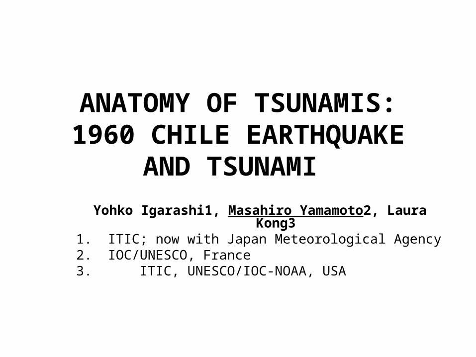
Timeline of 22 May 1960, Chilean Tsunami

Tsunami propagation maps Manually created (JMA) TTT software (NOAA)
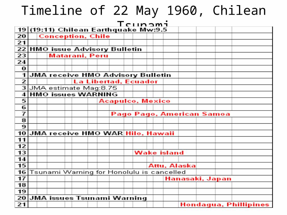
Stations in the Anatomy

Talcahuano, Chile(TTT: 49 min, Max run-up 25 m)
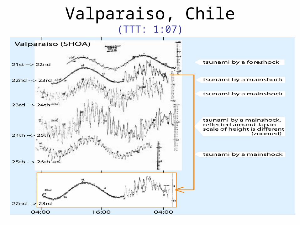
Valparaiso, Chile(TTT: 1:07)
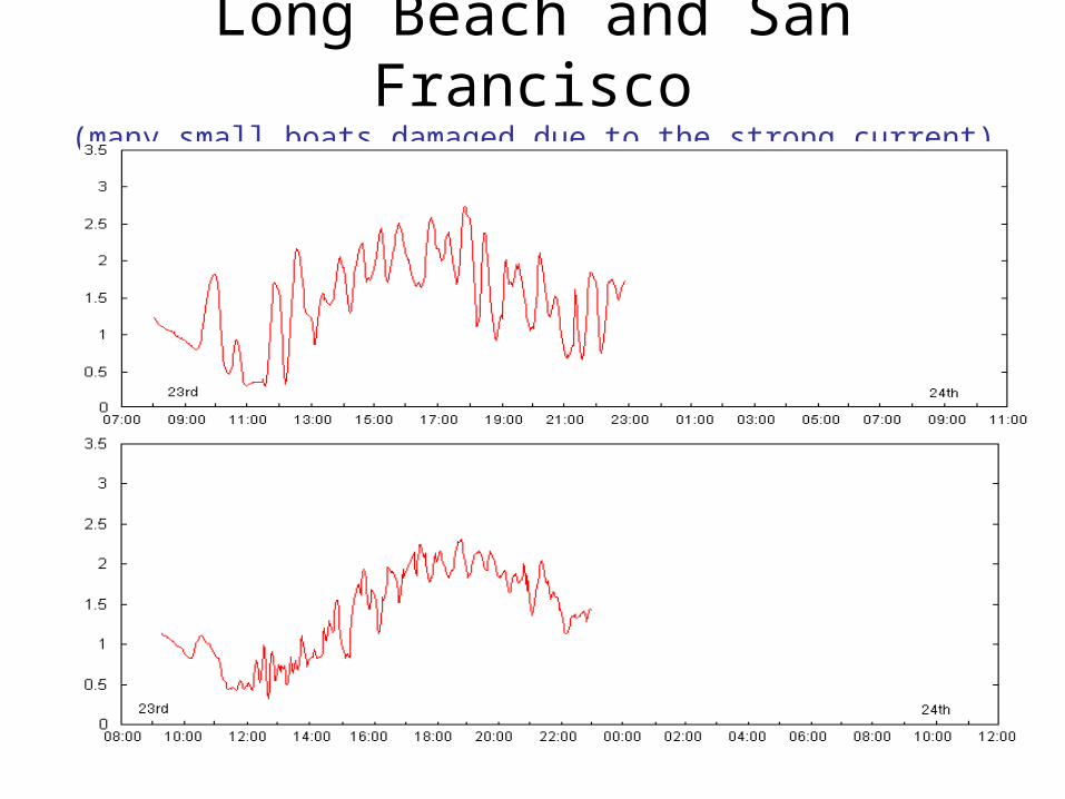
Long Beach and San Francisco(many small boats damaged due to the strong current)

Hilo, Hawaii (TTT:14:50 Max in Hilo: over 10m )

Honolulu, Hawaii (35 min after Hilo)

Johnston Island and Christmas Island
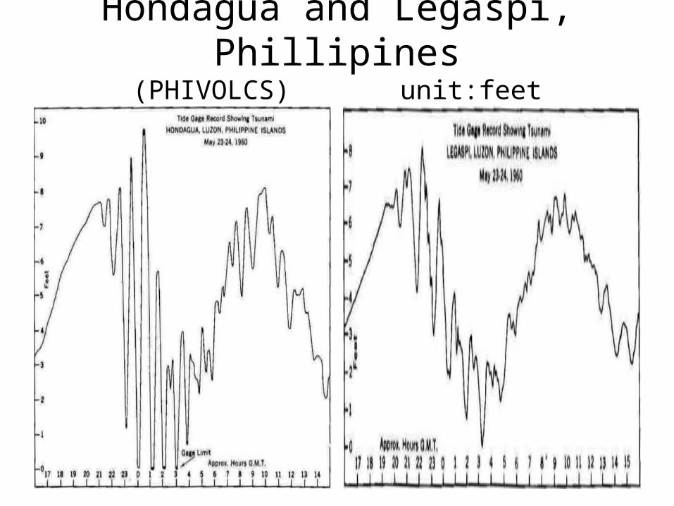
Hondagua and Legaspi, Phillipines(PHIVOLCS) unit:feet

Hong Kong (TTT: 27:37)
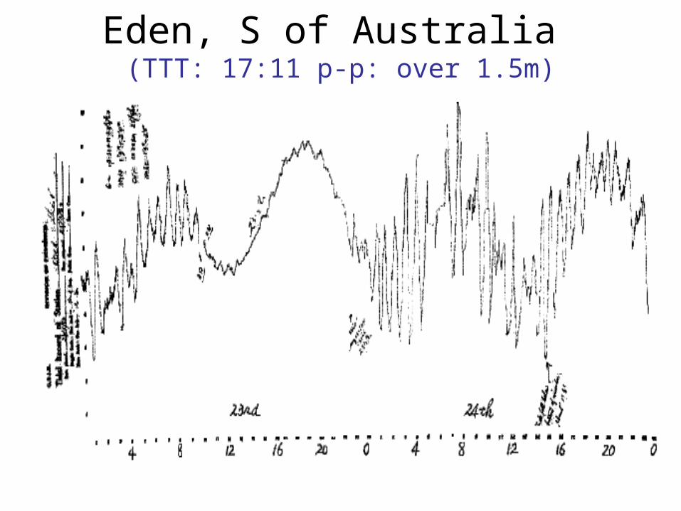
Eden, S of Australia (TTT: 17:11 p-p: over 1.5m)

Hanasaki and Kushiro, Japan (TTT: 21:30)
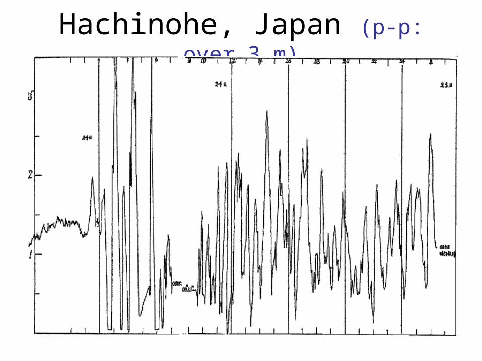
Hachinohe, Japan (p-p: over 3 m)
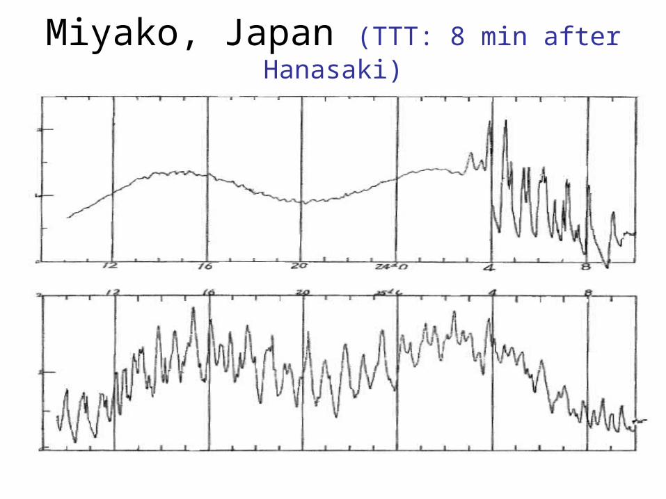
Miyako, Japan (TTT: 8 min after Hanasaki)

Onahama, Japan (TTT: 30 min after Hanasaki)
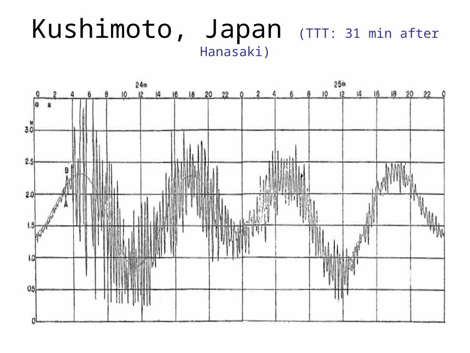
Kushimoto, Japan (TTT: 31 min after Hanasaki)

Tosashimizu, Japan (TTT: 57 min after Hanasaki)

Lessons learned from this
• A tsunami warning system for local, regional and far-field tsunami.
• International cooperation on information is required for such far events.
• Discuss and study well to exchange more precise and adequate information in advance.
• To enhance the knowledge on tsunami• End to End tsunami warning system

UNESCO/IOC Intergovernmental Coordination Group
(ICG)
Pacific Indian Ocean Carribbean MediterraneanPTWS IOTWS CARIBE NEAM
1965/2005 2005 2005 2005
Risk Assessment Seismic Detection system Hazard AssessmentDetection/Warning Sea level Hazard Assessment Seismic
Awareness Risk Assessment Communication Sea levelModelling Preparedness Public Awareness
Central America InteroperabilitySE Pacific MitigationSW Pacific
S China Sea
25th Session IOC-UNESCO Assembly 24
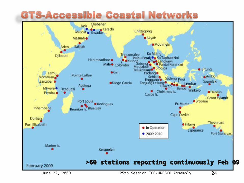
>60 stations reporting continuously Feb 09>60 stations reporting continuously Feb 09
June 22, 2009

Planned Workshop on Post Tsunami Survey
• Many NTWCs are under establishing• Need to develop common, harmonized and
standardized survey procedure• Comprehensive survey from all aspects• Advanced methods; GPS, GIS, Satellite etc
Revision of Post-Tsunami Field Guide (IOC Manuals and Guides 37, 1998 UNESCO)
Bridge between Research and Operational community