Analysis of Meadow Hydrology, Vegetation, and Soils and ...
19
Analysis of Meadow Hydrology, Vegetation, and Soils and Suggestions for Restoration of upper Halstead Meadow, Sequoia National Park, California Report Prepared for: Sequoia National Park By: David J. Cooper, Ph.D. and Evan C. Wolf, M.S. Department of Forest, Rangeland, and Watershed Stewardship Colorado State University, Fort Collins, CO 80523 February 2006
Transcript of Analysis of Meadow Hydrology, Vegetation, and Soils and ...

Analysis of Meadow Hydrology, Vegetation, and Soils and Suggestions for Restoration of upper Halstead Meadow,
Sequoia National Park, California Report Prepared for: Sequoia National Park
By:
David J. Cooper, Ph.D. and Evan C. Wolf, M.S. Department of Forest, Rangeland, and Watershed Stewardship
Colorado State University, Fort Collins, CO 80523
February 2006

Introduction
Wet meadows are uncommon yet striking and ecologically important features in Sequoia National Park. They are the primary ecosystems not dominated by woody plants, and they have very high herbaceous plant production. In addition, they have seasonally or perennially saturated soils and provide critical habitat for many species of plants, amphibians, large and small mammals, and aquatic invertebrates. California’s montane conifer forests typically have a poorly developed herbaceous plant understory (Rundel et al. 1988, Barbour 1988). Thus, livestock use in the Sierra Nevada has been concentrated in meadows (Benedict 1982, Rundel et al. 1988). Very heavy stocking rates of both cattle and sheep occurred in Sierra meadows in the late 19
th
and early 20th
centuries (Kosco and Bartolome 1981, Allen and Bartolome 1989), and many meadows were severely degraded by the unregulated grazing (Ratliff 1985a). Although stocking rates have been reduced or eliminated in most areas, many meadows retain disturbance features from the period of heavy grazing, including eroded channels, unvegetated patches from heavy trampling and grazing, altered plant composition and reduced plant production (Vankat and Major 1972, Ratliff 1985a, b). Odion et al. (1988) found that 50-80% of grazed meadows now dominated by dry meadow plants were formerly wet meadows, and were in need of restoration.
Wet meadows in the Sierra Nevada have seasonal or perennial sheet flow of water, and channelized flows are either absent, seasonal, or small. In some meadows overuse apparently led to increased channelization and downcutting through the meadow sediments. Deep incision has been documented in several meadows in the Sierra Nevada (Wood 1975), including Halstead Meadow in Sequoia National Park, where the depth of incision is greater than 10 feet in many areas, and extends for nearly the entire length of the meadow (cover photo). This incision is actively headcutting, widening the channel, threatening to erode additional meadow areas, lowering the water table in increasingly large areas, which causes the death of the native wet meadow plants, producing excessive sedimentation into the stream, and creating even more of an eye-sore for visitors. Therefore, a critical need exists to restore the meadow.
However, to restore Halstead Meadow, information is needed on how meadows in the area function hydrologically, and what vegetation naturally occurs in intact meadows. In this report we present data on water table depth, and vegetation from 6 meadows, present a synthetic picture of water table and vegetation that would be a suitable goal for the Halstead Meadow restoration, and present preliminary specifications for the restoration of upper Halstead Meadow. Documentation and analysis of the hydrology, topography, and vegetation of lower Halstead Meadow will result from fieldwork planned for summer 2006.
1

Methods and Study Sites
Six meadows, including Halstead Meadow were analyzed. We wanted to analyze meadows with a range of watershed sizes and meadow gradients, but that did not have deep incisions or gullies. We chose Crescent, Log, Round, Dorst, and Cabin Meadows after site visits and consultation with park staff (Figure 1). Each meadow was topographically surveyed. The survey data are analyzed to determine the meadow slope and within-site gradients. These data are important for use in developing a plan for final configuration of Halstead Meadows surface topography. Within each meadow one to nine ground water monitoring wells were installed by hand augering, and a fully slotted PVC pipe was installed in each hole. The holes were then backfilled with native soil. Water table depth below the casing top was measured bi-weekly. Wells were topographically surveyed so that water table maps could be created.
In Halstead Meadow wells were installed in three locations: the upper portion of the meadow above the highway that is intact and unaffected by the gulley, the area of the upper meadow that is affected by the gulley, and the northern portion of the meadow below the highway.
In a 6.5 foot radius circle around each well a list of all vascular plants and major bryophytes was made in August of 2005, and the canopy coverage of each species estimated. These data were analyzed using indirect ordination by the computer program Detrended Correspondence Analysis (DCA) performed with PCOrd software (Mefford and McCune 2004). DCA plots the vegetation around each well in the ordination space, and samples that are closest to each other have more similar vegetation than those more distant in the ordination space. This analysis is used to compare the floristic composition of vegetation in Sequoia meadows, and how the vegetation of the intact and gullied portions of Halstead Meadow compare with other meadows. These data are then used to develop an understanding of the vegetation that occupied Halstead Meadow historically, and for developing a planting plan for Meadow restoration.
2

Figure 1. Site map, showing the location of the six study meadows.
3
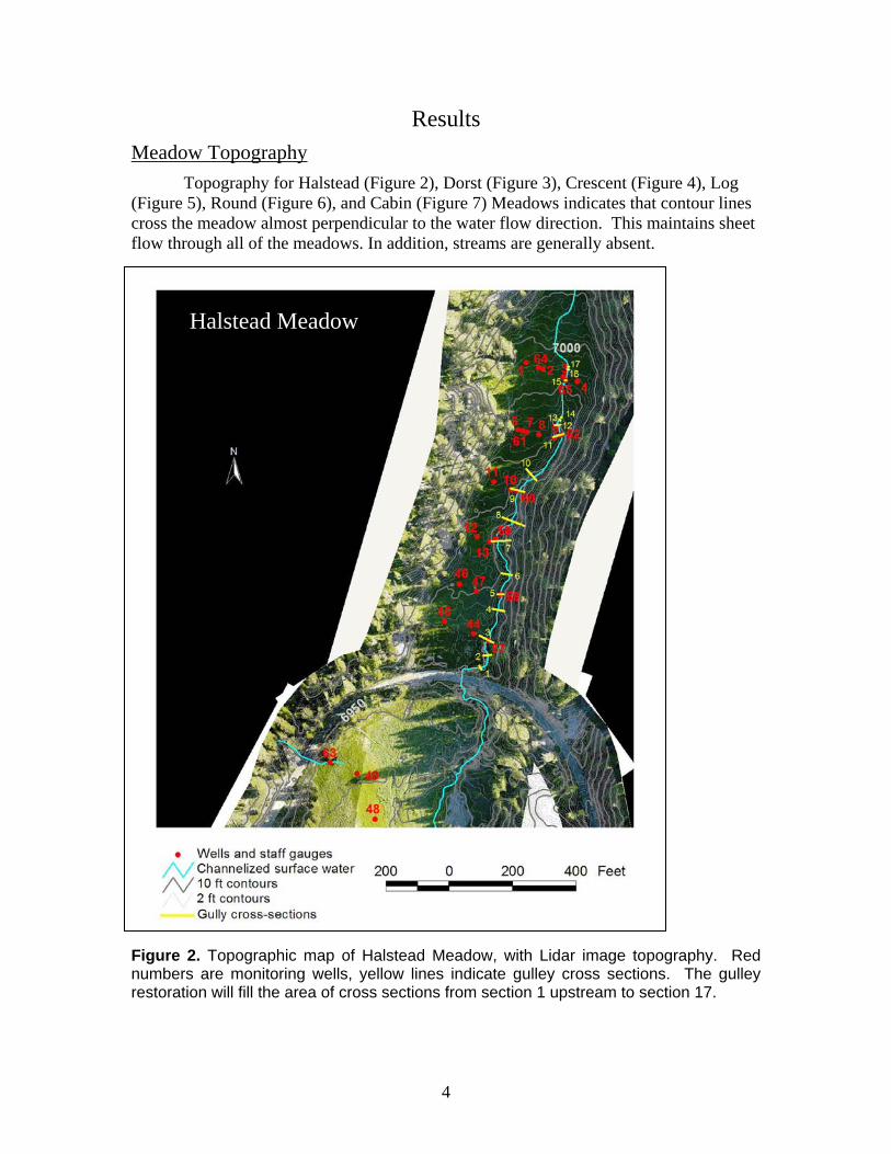
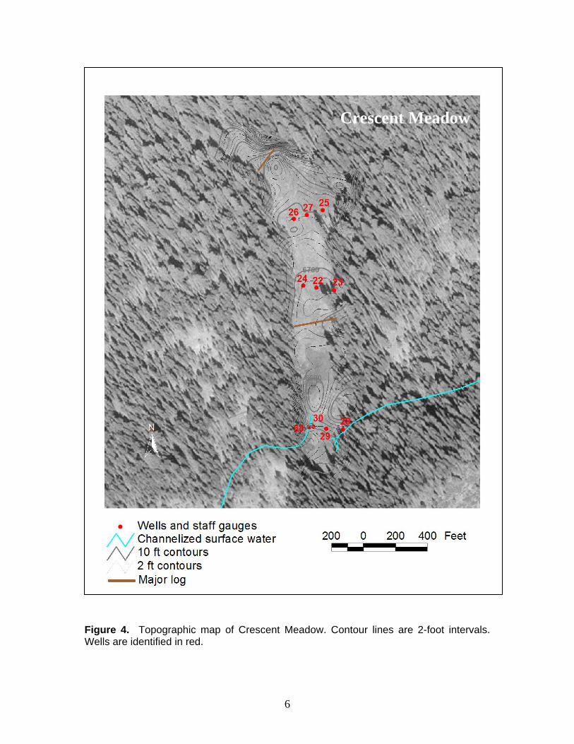
Results Meadow Topography
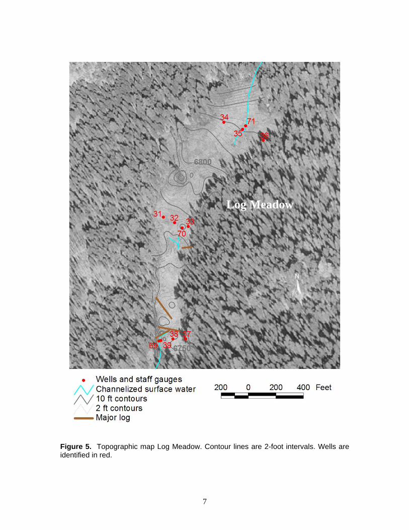
Topography for Halstead (Figure 2), Dorst (Figure 3), Crescent (Figure 4), Log (Figure 5), Round (Figure 6), and Cabin (Figure 7) Meadows indicates that contour lines cross the meadow almost perpendicular to the water flow direction. This maintains sheet flow through all of the meadows. In addition, streams are generally absent.
Fnr
igure 2. Topographic map of Halstead Meadow, with Lidar image topography. Red umbers are monitoring wells, yellow lines indicate gulley cross sections. The gulley estoration will fill the area of cross sections from section 1 upstream to section 17.
Halstead Meadow
4

Dorst Meadow
Figure 3. Dorst Meadow, showing elevation contours, and wells in red.
5
Crescent Meadow
Figure 4. Topographic map of Crescent Meadow. Contour lines are 2-foot intervals. Wells are identified in red.
6
Log Meadow
Figure 5. Topographic map Log Meadow. Contour lines are 2-foot intervals. Wells are identified in red.
7

Round Meadow
Figure 6. Topographic map of Round Meadow. Contour lines are 2-foot intervals. Wells are identified in red.
8

Cabin Meadow
Figure 7. Topographic map of Cabin Meadow. Contour lines are 2-foot intervals. Wells are identified in red.
9

Four cross-sections of the gully in upper Halstead Meadow are shown in Figure 8 and indicate the depth of incision.
W Feet E0 20 40 60
Feet
(4.2
x ve
rtica
l exa
gera
tion)
0
2
4
6
8
10
121
W Feet E0 20 40 60
Feet
(4.2
x ve
rtica
l exa
gera
tion)
0
2
4
6
8
10
127
W Feet E0 20 40 60
Feet
(4.2
x ve
rtica
l exa
gera
tion)
0
2
4
6
8
10
1211
W Feet E0 20 40 60
Feet
(4.2
x ve
rtica
l exa
gera
tion)
0
2
4
6
8
10
1216
Figure 8. Surveyed cross-sections 1, 7, 11, and 16 of the gully at Halstead Meadow. Cross sections are identified on Figure 2.
10
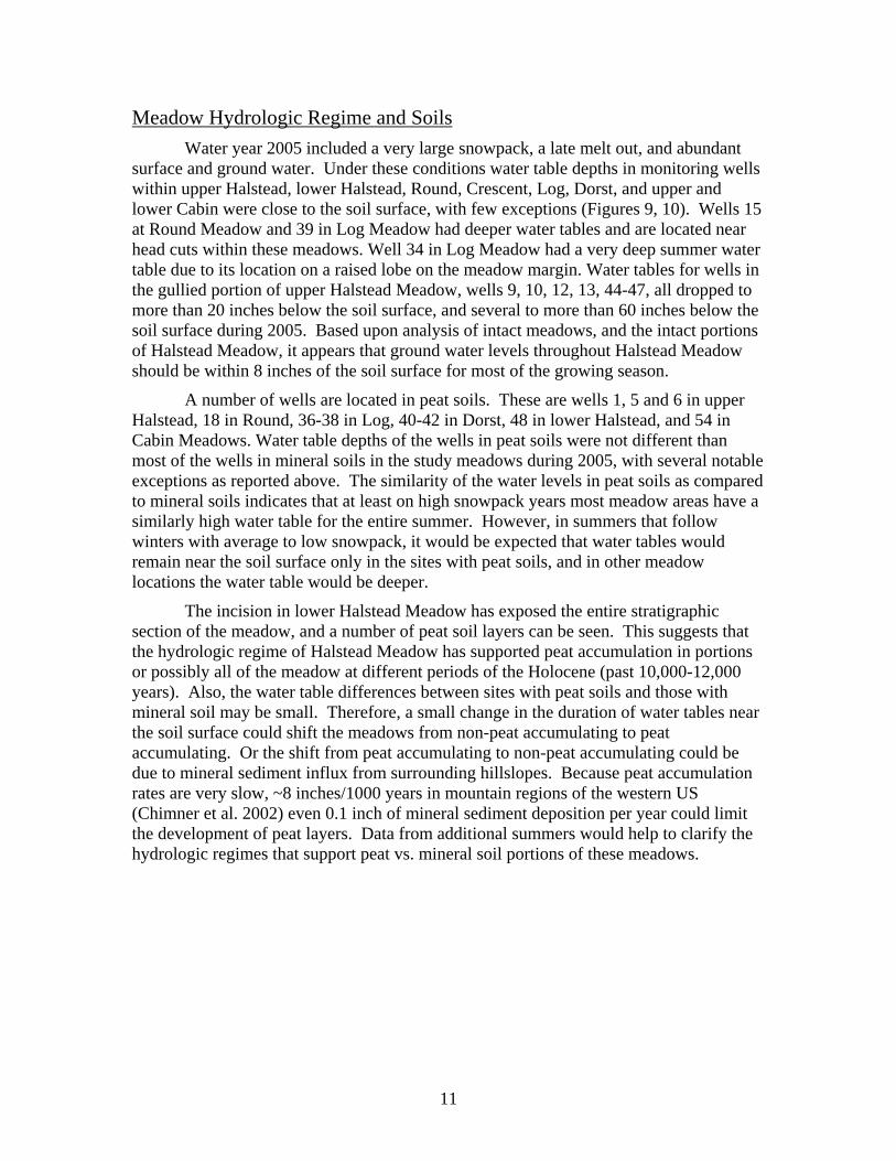
Meadow Hydrologic Regime and Soils Water year 2005 included a very large snowpack, a late melt out, and abundant
surface and ground water. Under these conditions water table depths in monitoring wells within upper Halstead, lower Halstead, Round, Crescent, Log, Dorst, and upper and lower Cabin were close to the soil surface, with few exceptions (Figures 9, 10). Wells 15 at Round Meadow and 39 in Log Meadow had deeper water tables and are located near head cuts within these meadows. Well 34 in Log Meadow had a very deep summer water table due to its location on a raised lobe on the meadow margin. Water tables for wells in the gullied portion of upper Halstead Meadow, wells 9, 10, 12, 13, 44-47, all dropped to more than 20 inches below the soil surface, and several to more than 60 inches below the soil surface during 2005. Based upon analysis of intact meadows, and the intact portions of Halstead Meadow, it appears that ground water levels throughout Halstead Meadow should be within 8 inches of the soil surface for most of the growing season.
A number of wells are located in peat soils. These are wells 1, 5 and 6 in upper Halstead, 18 in Round, 36-38 in Log, 40-42 in Dorst, 48 in lower Halstead, and 54 in Cabin Meadows. Water table depths of the wells in peat soils were not different than most of the wells in mineral soils in the study meadows during 2005, with several notable exceptions as reported above. The similarity of the water levels in peat soils as compared to mineral soils indicates that at least on high snowpack years most meadow areas have a similarly high water table for the entire summer. However, in summers that follow winters with average to low snowpack, it would be expected that water tables would remain near the soil surface only in the sites with peat soils, and in other meadow locations the water table would be deeper.
The incision in lower Halstead Meadow has exposed the entire stratigraphic section of the meadow, and a number of peat soil layers can be seen. This suggests that the hydrologic regime of Halstead Meadow has supported peat accumulation in portions or possibly all of the meadow at different periods of the Holocene (past 10,000-12,000 years). Also, the water table differences between sites with peat soils and those with mineral soil may be small. Therefore, a small change in the duration of water tables near the soil surface could shift the meadows from non-peat accumulating to peat accumulating. Or the shift from peat accumulating to non-peat accumulating could be due to mineral sediment influx from surrounding hillslopes. Because peat accumulation rates are very slow, ~8 inches/1000 years in mountain regions of the western US (Chimner et al. 2002) even 0.1 inch of mineral sediment deposition per year could limit the development of peat layers. Data from additional summers would help to clarify the hydrologic regimes that support peat vs. mineral soil portions of these meadows.
11

Cabin
May Jun Jul Aug Sep Oct Nov Dec
Wat
er ta
ble
(ft)
-6
-4
-2
0
Well 50
Upper Cabin
May Jun Jul Aug Sep Oct Nov Dec
Wat
er ta
ble
(ft)
-6
-4
-2
0
Well 51Well 52Well 53Well 54
Stream staff gauges
May Jun Jul Aug Sep Oct Nov Dec
Wat
er le
vel (
ft)
0
1
2
3
4
Upper CabinDorstHalsteadHalsteadHalsteadHalsteadHalsteadHalsteadL. HalsteadHalsteadHalsteadRoundRoundCrescentLogLogLog
Figure 9. Water table depths for ground water monitoring wells in Upper and lower Cabin Meadow, and stream stage for all surface flows in all meadows during 2005.
12

Upper Halstead
May Jun Jul Aug Sep Oct Nov Dec
Wat
er ta
ble
(ft)
-6
-4
-2
0
Well 1Well 2Well 3Well 4Well 5Well 6Well 7Well 8Well 9
Upper Halstead
May Jun Jul Aug Sep Oct Nov Dec
Wat
er ta
ble
(ft)
-6
-4
-2
0
Well 13Well 44Well 45Well 46Well 47Well 9Well 10Well 12
Round
May Jun Jul Aug Sep Oct Nov Dec
Wat
er ta
ble
(ft)
-6
-4
-2
0
Well 14Well 15Well 16Well 17Well 18Well 19Well 20Well 21
Crescent
May Jun Jul Aug Sep Oct Nov Dec
Wat
er ta
ble
(ft)
-6
-4
-2
0
Well 22Well 24Well 25Well 26Well 27Well 28Well 29Well 30
Log
May Jun Jul Aug Sep Oct Nov Dec
Wat
er ta
ble
(ft)
-6
-4
-2
0
Well 31Well 32Well 33Well 34Well 35Well 36Well 37Well 38Well 39
Dorst
May Jun Jul Aug Sep Oct Nov Dec
Wat
er ta
ble
(ft)
-6
-4
-2
0
Well 40Well 41Well 42Well 43
Lower Halstead
May Jun Jul Aug Sep Oct Nov Dec
Wat
er ta
ble
(ft)
-6
-4
-2
0
Well 48Well 49
Figure 10. Water table depths for ground water monitoring wells in Halstead, Round Crescent, Log and Dorst Meadows during 2005.
13

Vegetation Analysis The DCA analysis of vegetation data (Figure 7) indicates that most wet meadow
plots are on the left side of the ordination space, have similar vegetation, and are dominated by Oxypolis occidentalis, Scirpus microcarpus, Glyceria elata and Eleocharis pauciflora. On the right side of the ordination space are plots located where gullying has dried the soils. These plots, mostly located in Halstead Meadow just above the highway, are dominated by Heracleum lanatum, Mertensia cilatia, Rumex salicifolius var. denticulatus and Senecio triangularis. Plots from the very upper portion of Halstead and the northern portion of Halstead below the highway, both of which have high water tables throughout the summer, are plotted on the left side of the ordination space. Plots with peat soils are identified with green symbols. Those with mineral soils and high water tables are brown and those with mineral soils and deep water tables by red triangles.
Figure 11. Detrended correspondence analysis (DCA) ordination of meadow vegetation. Brown circles are plots with perennially high water tables and mineral soils, green circles are plots with perennially high water tables and organic soils, red triangles are plots with deep water tables and mineral soils. The centroids of key plant species are shown. Plants in CAPS, SCIR = Scirpus microcarpus, GLYC = Glyceria elata and OXYP = Oxypolis occidentalis are dominants in many meadows. Other species are Phfo = Philonotis fontana, Elpa = Eleocharis pauciflora, Caqu = Camassia quamash, , Salix = Salix spp., Eqar = Equisetum arvense, Veca = Veratrum californicum, Caca = Calamagrostis canadensis, Stal = Stachys albens, Cale = Carex lemmonii, Setr = Senecio triangularis, Hela = Heracleum lanatum, Meci = Mertensia ciliata, Rusa = Rumex salicifolius var. denticulatus.
14

Synthesis
The natural portions of all six meadows investigated during 2005 had water tables near the soil surface for the entire summer, with few exceptions. Water moved as sheet flow across the meadows through most of the summer. Sheet flow occurs due to the very flat meadow profile perpendicular to the direction of water flow. The influence of a high density of Scirpus microcarpus, Oxypolis occidentalis and Glyceria elata culms, and large wood from fallen trees also disperses the flow and prevents the formation of rills and channels.
The only locations with a water table deeper than ~8 inches below the soil surface at any time during the summer of 2005 occurred in Halstead Meadow above the highway, and in three wells in Log and Crescent Meadow that were associated with localized head cuts and meadow margins. The incision in Halstead Meadow has lowered the water table in the meadow above the highway, in the area downstream from the point where the headcut has its northern edge (shown in green in Figure 12). The hydrologic restoration goal for Halstead Meadow should be to reestablish the sheet flow of water through the meadow that can maintain a water table near the soil surface for most of the summer across the entire meadow. The vegetation goals should be the establishment of a complete cover of Scirpus microcarpus, Oxypolis occidentalis and Glyceria elata throughout the meadow.
Suggested Restoration Approaches Earthwork and Grading
To restore the sheet flow hydrologic system in Halstead we recommend filling the entire gully with layers of mineral sediment, including rock, and creating a flat meadow surface, as occurs in all of the reference meadows perpendicular to the flow direction. A temporary road could be constructed from the Generals Highway into the meadow, and along the channel. Truck loads of material can be dumped into the channel once the stream flow is diverted out of the channel. A small bulldozer can spread and compact the sediments. The channel should be filled to a level that allows for some settling. Areas of the meadow that have been eroded may also require additional minor filling or grading to reestablish the lateral continuity across the meadow.
We suggest installing at least 12 logs perpendicular to the flow direction. These logs probably can be taken from adjacent hillslope areas. The coarse woody debris will help dissipate flow energy and spread water evenly across the meadow, as occurs in all of the study meadows. In addition, netting could be used to stabilize the bare soil surface where the meadow transitions to the highway culverts, and in other areas of bare soil where erosion during the winter of 2006-2007 might occur.
Earthwork should occur in the fall when water tables are deepest, and flow in the gully is lowest. Once the gully is filled, surface water can be allowed to flow across the meadow.
15

Planting Plan Our vegetation data indicates that most intact meadows in the study area are
dominated by Scirpus microcarpus, Oxypolis occidentalis and Glyceria elata. Thus, we recommend that the restoration of Halstead Meadow include the planting of these three species grown from seed collected in Halstead Meadow. The seed should be cold stratified, germinated and grown in tubes that can be planted in the spring following the implementation of the earthwork. We suggest planting at a density of 5 seedlings/yard2 using a ratio of 3:1:1 of Scirpus microcarpus, Oxypolis occidentalis and Glyceria elata. No fertilizer should be applied at any time. The plants should be propagated during the spring of 2007, for planting on approximately 1 June 2007.
Highway Issues
The restoration should extend downstream in Halstead Meadow to within ~50 feet of the highway. At that point, the water should be collected in a depression and moved to the existing culverts where it can flow under the highway and into the lower meadow.
For the future restoration of Halstead Meadow below the highway, it is critical that the sheet flow system, which will be restored in upper Halstead meadow, extends uninterrupted from the upper Meadow under the road and into the lower portion of the meadow. This will help restore the appropriate hydrologic regime through the entire meadow. The restoration of this hydrologic system would be greatly facilitated by the construction of a highway bridge over the meadow. The installation of culverts or channels to convey water flow likely has contributed to incision into the meadow sediments that the existing projects are trying to restore, and are inappropriate. In addition, the bridge should be as high above the meadow surface as possible, to allow the placement of sediments and plants directly under the bridge, if possible, and a stable transition from the bridge to the lower meadow is critical in linking restoration efforts from the upper to lower meadow.
16

Figure 12. Air photograph of the upper Halstead Meadow restoration site. The area in red, 0.894 acres, is the gulley proposed for filling. The area in green, 1.633 acres, has been drained by the gulley, and has lost its natural vegetation, and is now dominated by Heracleum lanatum, Mertensia ciliata and other native, but exotic species to this portion of the meadow. This area should be planted with Scirpus microcarpus, Oxypolis occidentalis, and Glyceria elata.
17
Literature Cited Allen, B.H., and J.W. Bartolome. 1989. Cattle grazing effects on understory cover and
tree growth in mixed conifer clearcuts. Northwest Science 63: 214-220.
Barbour, M. 1988. California upland forests and woodlands. Chapter 5, in M. Barbour
and W. Billings eds. North American Terrestrial vegetation. Cambridge
University Press.
Benedict, N.B. 1982. Mountain meadows: stability and change. Madrono 29: 148-153.
Chimner, R.A., D.J. COOPER and W. J. Parton. 2002. Modeling carbon accumulation in
Rocky Mountain fens. Wetlands 22:100-110.
Kosco, B. and J. Bartolome. 1981. Forest grazing: past and future. J. Range Man. 34:
248251.
Odion, D. T. Dudley, C. D’Antonio. 1988. Cattle grazing in southeastern Sierran
meadows: ecosystem change and prospects for recorvery. Plant biology of eastern
Calif. The Mary DeDecker Symposium, Natural History of the White Inyo
Range. Univ of Calif. White Mt. Research Station 2: 277-292.
Ratliff, R. 1985a. Meadows in the Sierra Nevada of California: state of knowledge. U.S.
For. Serv. Gen Tech Rep. PSW-60, 52 p.
Ratliff, R. 1985b. Nutrients in Carex exserta sod and gravel in Sequoia National Park,
Calif. Great Basin Naturalist 45: 61-65.
Rundel, P., D. Parsons, D. Gordon. 1988. Montane and subalpine vegetation of the Sierra
Nevada and Cascade Ranges. Chapter 17, in Terrestrial Vegetation of California.
M. Barbour and J. Major Editors. Calif. Native Plant Society.
Vankat, J and J. Major. 1978. Vegetation changes in Sequoia National Park, California. J.
Biogeography 5: 377-402.
Wood, S. 1975. Holocene stratigraphy and chronology of mountain meadows, Sierra
Nevada, CA. Ph.D. Dissertation, Calif. Inst. Technology, Pasadena, CA. 179p.
18