
An ocean is an example of water movement we can see on ...
9
1 Hydrogeology is an area of geology that discusses the movement of water on the surface of the Earth or underground. We can easily see water movement that occurs in oceans, lakes, rivers, and streams, but what about underground? In this reading, you will learn about the Kirkwood-Cohansey aquifer, other aquifers, and terminology in order to understand how significant this water source is to southern New Jersey. What is an aquifer? An aquifer is an underground layer of porous rocks and sediments where groundwater is present as a result of precipitation and/or melted snow that has seeped into the ground. It is important to understand that aquifers only occupy certain areas underground because they form from porous (spaces that water can pass through) water-bearing rock formations. An ocean is an example of water movement we can see on Earth’s surface. This photo was taken at Seaside Heights, New Jersey.
Transcript of An ocean is an example of water movement we can see on ...

1
Hydrogeology is an area of geology that discusses the movement of water on the surface of the Earth or underground. We can easily see water movement that occurs in oceans, lakes, rivers, and streams, but what about underground? In this reading, you will learn about the Kirkwood-Cohansey aquifer, other aquifers, and terminology in order to understand how significant this water source is to southern New Jersey.
What is an aquifer?
An aquifer is an underground layer of porous rocks and sediments where groundwater is present as a result of precipitation and/or melted snow that has seeped into the ground. It is important to understand that aquifers only occupy certain areas underground because they form from porous (spaces that water can pass through) water-bearing rock formations.
An ocean is an example of water movement we can see on Earth’s surface. This photo was taken at Seaside Heights, New Jersey.

2
How do aquifers relate to the hydrologic cycle?
Do you ever wonder where the majority of water stored in the soil, plants, and water bodies go? The hydrologic cycle, also known as the water cycle, has the answer for us! Much of this water transforms into water vapor- the gaseous phase of the water cycle known as evaporation. This water rises to the atmosphere and condenses to form clouds. The gaseous phase transforming into a liquid phase is known as condensation. Eventually, water will fall to the surface of Earth in the form of precipitation (rain, snow, sleet, hail, etc.), which occurs when the water vapor that has condensed in the clouds can no longer hold any more water vapor.
Some of this water that falls to Earth’s surface will contribute to runoff, which is when water flows into surface waters such as lakes, rivers, and streams. Water that does not runoff will typically seep into the ground in a process known as recharge as it makes its way down to the aquifer. Groundwater flow continues to lower elevations through cracks and spaces underground. After many years of this underground water movement, the groundwater will eventually reach a discharge area, in which it enters a lake or a stream and becomes surface water.
The hydrologic cycle repeats this process over and over again. Without the hydrologic cycle, life would not be as we
know it today, for life is dependent upon water. It is a natural phenomenon that is essential for the distribution of fresh water on Earth’s surface and for living organisms, such as us humans.
Why are aquifers important?
It would be difficult to imagine a world without aquifers because they are one of our most prominent sources of freshwater. According to the National Oceanic and Atmospheric Administration (NOAA), about 30 percent of our freshwater is derived from aquifers.
Diagram of the Hydrologic Cycle (Water Cycle)

3
One reason why such aquifers are so important is because they provide drinking water to people that have a well. It is safe to drink the groundwater in aquifers as long as the water coming from the well is tested from time to time. Treatment is often necessary for well owners because groundwater can be prone to certain contaminants depending on the geology of a specific location in addition to several other factors.
Another reason why aquifers are important is because they prevent surface waters such as lakes, rivers, and streams from flooding. When there is excess precipitation, the aquifers beneath such surface waters can collect this excess water and therefore, prevent flooding.
A big issue concerning aquifers is that the vast majority of them are being depleted (in other words, used up) at a faster rate than the water can be replenished. This is caused by pumping water out of the ground at a rate that cannot be sustained. In this case, the term “sustained” meaning there is enough water to be pumped at a rate that is continuous for a period of time without being delayed.
What is the Kirkwood-Cohansey Aquifer and where is it located?
The Kirkwood-Cohansey Aquifer is an underground freshwater reservoir that supplies water to lakes, streams, rivers, and wetlands. It is an unconfined aquifer, meaning that the groundwater is close to the surface and can seep from the land surface to the water table. Some of the groundwater from this aquifer leaks to deeper confined aquifers. Confined aquifers are defined as layers of impermeable rock or clay that do not permit the passage of water further downward.
Map of New Jersey. As you can see, the Kirkwood-Cohansey aquifer makes up most of the Coastal Plain region.

4
This aquifer is named after the Kirkwood and Cohansey geologic formations. It is based throughout most of southern New Jersey in the Coastal Plain physiographical province.
What is the difference between the Cohansey Formation and the Kirkwood Formation?
Although both the Cohansey Formation and Kirkwood Formation make up the same aquifer, they differ in that they are separate geologic units. The Kirkwood Formation is comprised of both sand and clay beds whereas the Cohansey Formation is mostly comprised of sand and small amounts of silt, clay and gravel. Both formations date to the Miocene epoch (around 5 million to 23 million years ago) with the Cohansey being the younger of the two.
Basic Components of an Aquifer (shown in image diagram below):
• Water Table: The upper surface that makes up the zone of saturation. This zone of saturation is defined by pores and fractures being saturated (filled) with water.
• Confining Bed: An impermeable layer of rock or unconsolidated sediments that impedes the movement of water.
• Unconfined Aquifer: A layer that is typically located below major water sources such as a river or stream. Such water sources seep downward to form this specific layer.
• Confined Aquifer: A saturated layer of sediments between (above and below) confining beds.
Other Basic Components of an Aquifer:
Water table
Sandy soil
Confining beds Confined aquifer
Unconfined aquifer

5
• Water Table Aquifer: An unconfined aquifer that exists at or just below the surface layer and supplies and/or receives water from rivers, lakes, streams, and precipitation.
• Groundwater Recharge: The downward movement of water from the surface to groundwater
• Groundwater Discharge: The movement of water from the subsurface to the surface
Hydrologic Properties:
The majority of the Kirkwood-Cohansey Aquifer is comprised of well-sorted sand, meaning that the sand grains are of similar size. The aquifer is also comprised of medium to coarse-grained sand. Such characteristics make this aquifer highly permeable, meaning that water can easily move through these sand layers. Permeability is an important factor in relation to aquifers since it refers to how readily water can flow through interconnected cracks or spaces. It is also important because the permeability will tell us whether it will be easy to extract water from a given aquifer.
We can determine the hydrologic properties of an aquifer by conducting aquifer pumping tests. With these specific tests, the water in the aquifer is pumped continously to obtain important information and data. Pumping tests for the Kirkwood-Cohansey Aquifer have revealed that it has unconfined-aquifer characteristics (clay layers that are few or absent).
Well Yields:
A map conveying the two geologic units of the Kirkwood-Cohansey aquifer.
6
The yield of an aquifer is the volume of water that can be supplied instantly and be sustained at a rate that is continous for over an extended period of time. Yield can tell us how much water can be supplied to wells. The term high-capacity wells is used to define wells sited and tested for maxiumum yield. This includes muncipal water supply, irrigation, and industrial-supply wells. High-capacity wells that have been tested in the Kirkwood-Cohansey aquifer have demonstrated that it is abundant in terms of yield.
The New Jersey Department of Environmental Protection (NJDEP) collected data from 938 high-capacity wells and the data reveals that the aquifer can produce yields up to 4,500 gallons per minute (gpm), with the average yield being 400 gpm. To get an idea of how much water 400 gpm is, we can think in terms of how much water an individual typically uses in a day. The average person uses about 80 to 100 gallons of water per day in the United States. That means the average yield in gallons per minute of high-capacity wells of the Kirkwood-Cohansey aquifer is between 4-5 times the amount of water the average person uses in a day. That’s a lot of water!
Water Use:
Most of the water withdrawn from the Kirkwood-Cohansey Aquifer is used for potable consumption (drinkable water). Agricultural irrigation is the second largest category for water use from this aquifer. This type of irrigation method is significant because it allows farmers to grow crops more efficiently and reliably. The third largest water user is the mining industry. You may be surprised that mining is categorized for vast water use. Water is needed to drain sand pits for mineral extraction. Other significant water uses include commercial, industrial and nonagricultural irrigation.
Water Quality:
Some characteristics of the Kirkwood-Cohansey Aquifer include it being fresh, acidic, highly corrosive, and low in dissolved solids. Due to these characteristics, it is not uncommon to encounter the contaminants radium and mercury in the groundwater of this aquifer. Radium occurs naturally in the Kirkwood-Cohansey aquifer, but it exceeds the safe amount allowed for drinking water. Agricultural land use contributes to increased levels of nitrates in the water, which increases the abundance of radium that dissolves into groundwater from contact with sand and soil. Mercury, however, is believed to result from human activity.
Contamination Vulnerability:
The Kirkwood-Cohansey water-table aquifers are prone to contamination because they lack protective confining layers, which block the vertical movement of water from the surface. This is why the Kirkwood-Cohansey aquifer is considered an unconfined aquifer. As discussed earlier, a

7
confining layer is usually comprised of clay or rock and it prevents the movement of water because of its low permeability and porosity potential. Although there are clay lenses within the aquifer, they are typically discontinuous, which ultimately results in the downward movement of surface contamination. Clay lenses form confining beds in particular areas of the aquifer.
What is the historical significance of the Kirkwood-Cohansey Aquifer and the land above?
The soil overlaying the Kirkwood-Cohansey Aquifer consists of much of the same material as the aquifer itself and is thus an excellent source of fine clays for pottery and brick making.
The sand has been used since colonial times in glassmaking. Fine-grained iron deposits that leach through the ground accumulate and are used as a crude source of iron ore known as bog iron. Much of the iron used during the Revolutionary War for weapons was mined here. The trees were used for lumber, firewood, charcoal, and paper production. The soil itself is very porous and drains quickly, limiting the variety of commercial farming – thus early settlers dubbed the area as the “Pine Barrens” because pine trees flourish in sandy soil while crops such as corn and wheat cannot tolerate the acidity.
In 1876, a large portion of land was purchased by Philadelphia industrialist Joseph Wharton to be used as a source of water for the cities of Camden and Philadelphia. Wharton’s plan was cancelled when the state legislature banned the export of water out of New Jersey borders. Wharton’s name may be familiar. Wharton State Forest is the largest in the state and includes Batsto Village, several ghost towns, camping, hiking, fishing, canoeing, kayaking and the slim chance of spotting the Jersey Devil!
The red coloration in this stream is bog iron (Harrisville, New Jersey)
8
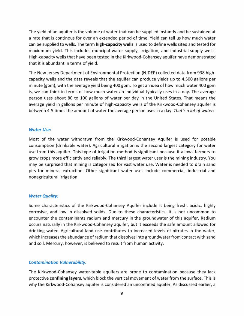
Today we refer to the region overlying much of the aquifer as the Pinelands. In 1979, 1.1 million acres of the Pinelands were set aside as the Pinelands National Reserve to protect the area as semi-wild. It is the largest such area between Boston, Massachusetts and Richmond, Virginia. The Pinelands are home to a great variety of plants and animals. The Pinelands Treefrog, considered threatened in New Jersey, is found in only a few other places in the country. Today, the major industries in the Pinelands include cranberry and blueberry production and tourism.
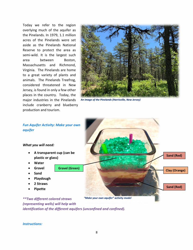
Fun Aquifer Activity: Make your own aquifer
What you will need:
• A transparent cup (can be plastic or glass)
• Water • Gravel • Sand • Playdough • 2 Straws • Pipette
**Two different colored straws (representing wells) will help with identification of the different aquifers (unconfined and confined).
Instructions:
An image of the Pinelands (Harrisville, New Jersey)
“Make your own aquifer” activity model
Sand (Red)
Clay (Orange)
Sand (Red)
Gravel (Green)

9
1. To begin, add sand to your transparent cup. 2. Slowly add water to the bottom sand layer so that the sand is saturated with water. 3. Add a layer of clay (playdough) on top of the sand layer. With this clay layer, the aquifer
can now be defined as confined because water will be unable to penetrate through the clay layer. Leave a small space of sand open so that a recharge area can be made. This will allow for water to travel through this confined aquifer.
4. Cut ¼ of a straw. This piece of the straw will represent a well. Place the well into the recharge area that you made.
5. Add more sand on top of the clay layer. Cut ¼ of another straw to insert into the sand layer. The sand layer above the clay represents an unconfined aquifer.
6. Place gravel above the sand layer and add water in order to saturate the aquifer. 7. Make a small hole in the gravel so that groundwater can be seen at the surface. 8. Using a pipette, extract water from both the wells. In other words, the unconfined and
confined aquifer.
What happened to the water in this activity?
When water is extracted from the confined aquifer, water levels decrease. When water is extracted from the unconfined aquifer, water table levels decrease. Groundwater is recharged naturally by means of precipitation. The amount of groundwater readily available depends on the rate at which water is being extracted from the wells and how much water is seeping into the aquifer, also known as groundwater recharge.
Share your knowledge:
Now that you know how important and vital the Kirkwood-Cohansey Aquifer is, you can share what you know about this aquifer with your family and friends who may not know about this vast aquifer. I guarantee you they will be impressed!