AN ISOLATED FRONTIER OUTPOST HISTORICAL AND … · an isolated frontier outpost historical and...
8
AN ISOLATED FRONTIER OUTPOST HISTORICAL AND ARCHAEOLOGICAL INVESTIGATIONS OF THE CARRIZO CREEK STAGE STATION SDW
Transcript of AN ISOLATED FRONTIER OUTPOST HISTORICAL AND … · an isolated frontier outpost historical and...

AN ISOLATED FRONTIER OUTPOST
HISTORICAL AND ARCHAEOLOGICAL INVESTIGATIONSOF THE CARRIZO CREEK STAGE STATION
SDW
AN ISOLATED FRONTIER OUTPOST:
HISTORICAL AND ARCHAEOLOGICAL INVESTIGATIONSOF THE CARRIZO CREEK STAGE STATION
By
Stephen R. Van WormerSue Wade
Susan D. WalterAnd
Susan Arter
June 30, 2007
Copyright 2007
California State Parks

Everybody goes armed here. If a man has noshirt to his back he will have his knife in his belt
(Phocion R. Way – San Antonio – San DiegoMail Line Passenger, 1858).
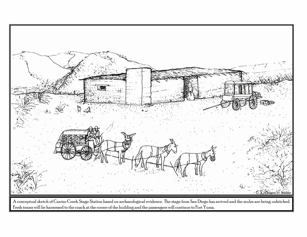
A conceptual sketch of Carrizo Creek Stage Station based on archaeological evidence. The stage from San Diego has arrived and the mules are being unhitched.Fresh teams will be harnessed to the coach at the corner of the building and the passengers will continue to Fort Yuma.
Susan D. Walter

1
I. INTRODUCTIONOn the western Colorado Desert, at the extreme southeast corner of Anza-Borrego Desert State Park, a
small stream, Carrizo Creek, trickles along a sandy wash for about two miles and then disappears back into
the coarse, dry soil. From 1857 to the middle 1870s a small adobe stage station stood on the banks of the
wash. Dependent on precarious overland supply lines and situated in an unsettled and sometimes lawless
country, Carrizo Creek Station was a small isolated frontier outpost, providing fresh horses for the coaches
of the Overland Mail, and food, drink, and occasionally a brief rest for weary travelers.
By the 1990s, nearly 130 years since the stage station fell into disuse, the site had suffered greatly from
grading and severe erosion and had nearly disappeared from the landscape (Figure 1A & B). With the
recognition that if no preservation efforts were undertaken, the site would soon be destroyed, California
State Parks’ archaeologists began investigations to determine what structures and features remained at the
site and what protection measures were necessary for its preservation. In 1999, California State Parks
Cultural Resource staff and District Archaeologist Rae Schwaderer recognized the need to archaeologically
explore the site and to stabilize whatever features might remain. Funding was dedicated to this task and
the research and fieldwork, under the direction of project leaders Sue A. Wade (Associate State
Archaeologist) and Stephen R. Van Wormer (State Historian II), began in 2000.
The first task was to define the research and environmental context within which the Carrizo Stage Station
exists—what historians of the route have called the Carrizo Corridor. The Carrizo Corridor, from Carrizo
Stage Station on the south to Warner Ranch on the north, spans approximately 50 miles, nearly 35 miles of
which lie within the southern portion of the Anza-Borrego Desert State Park (Figure 2). Three of the
stage-station sites lie within the park—San Felipe, Palm Springs, and the southernmost, Carrizo. In
addition to extensive historic research of the route and stage station sites, during March and April 2001
each of the three sites was surface surveyed and remote sensing and archaeological investigations were
completed. This testing was guided by the “Research Design for Archaeological Test Excavations at Three
Historic Stage Station Sites Along the Carrizo Corridor of the Butterfield Stage Route” (Wade and Wray
2001), and the test results are documented in “Archaeological Excavations at Carrizo Stage Station, Anza-
Borrego Desert State Park, California (Wade et al. 2001). Surface indications and remote sensing results
were sufficient to confirm the location and relative stability of the stage station site at San Felipe. Limited
shovel test pit explorations unfortunately located no remains at the Palm Springs site. At the current time,
it is unknown if or where remains of Palm Springs Stage Station still exist. A systematic archaeological
testing program was implemented at Carrizo Stage Station site. The initial field test excavations and artifact
analysis confirmed the presence of two structures and artifactual remains of the 1857-1870s Carrizo Stage
Station.

_____________________________________________________________________________________________________________________________________
FIGURE 1A: “Ruins of the old Butterfield Stage Station at Carrizo Creek,” late nineteenth century, view to northeast,
photograph by Frank Stephens, courtesy of San Diego Historical Society, Booth Photographic CollectionB: Carrizo Stage Station site, 1999, view to northeast, photograph by Christopher Wray
A
B
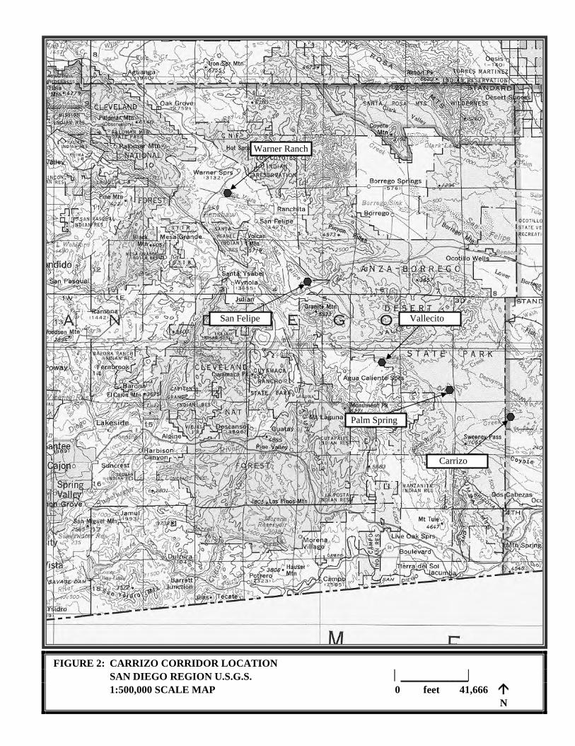
FIGURE 2: CARRIZO CORRIDOR LOCATION
SAN DIEGO REGION U.S.G.S. _____________
1:500,000 SCALE MAP 0 feet 41,666 N
Warner Ranch
San Felipe Vallecito
Palm Spring
Carrizo

4
At the conclusion of the testing, it was determined that the Carrizo Stage Station site is eligible for the
National Register of Historic Places because of its association with significant historical events—
transportation of people and goods along the Southern Overland Routes—and because it contains
important archaeological data concerning the site function and the past lifeways of the occupants. The
testing program also identified impacts from natural and human depredations that threatened the site’s
integrity and its National Register eligibility. Because of this unavoidable threat of destruction, a data
recovery program was recommended for the Carrizo Stage Station Site. An engineered erosion control and
stabilization plan was recommended to be implemented at the completion of the data recovery effort.
Interpretive activities were also proposed including recreating low adobe walls on the foundation alignment
and placing an interpretive panel. As well, the 150-year anniversary of the construction of the Carrizo
Stage Station and the opening of the stage route, in the year 2007, was identified as an ideal time to
commemorate this important segment of California history.
The recommended data recovery archaeological excavation program was implemented in 2002 and is the
subject of this report. At the completion of the excavations, with assistance by the California Conservation
Corps (CCC), the site was covered with porous geo-textile fabric, hand filled with excavation back dirt, and
capped with a two-to-four-foot layer of soil. The engineered water diversion measures, to reduce the
erosion danger to the site, were constructed by the CCC. While its artifactual information has been
removed and documented in this report, the site architecture remains preserved for the future below this
soil cap.
Archaeological field work, historic research, artifact analysis, and preparation of this report were completed
by the following people: Stephen R. Van Wormer (principal author, historic research, field and artifact
analysis co-supervisor); Sue A. Wade (project manager, field and artifact analysis co-supervisor, author);
Bonnie Bruce (archaeological field technician, artifact analyst, technical illustrator); Susan D. Walter
(artifact analyst) Steven Briggs and Delman James (archaeological field technicians); Heather Thomson
(archaeological field technician, research contributor); Christopher Wray (field assistant, research
contributor); Mike Volberg (field assistant, research contributor); Jeanie Jones (field assistant), Christopher
Garthe (field assistant). Valuable archaeological excavation assistance was provided by Southern Service
Center archaeological staff Marla Mealey, Michael Buxton, Patty McFarland, Karen Shabel, Michael
Sampson, and Carmen Zapeda. The California Conservation Corps assistance was invaluable in reburying
the site and constructing erosion protection features. The project could not have been completed without
the unfailing assistance provided by Colorado Desert Archaeological Society volunteers Sam and Astrid
Webb, Kerry Hunsinger, Carl Kennerson, Dave and Ruth Otis, and Richard Payne. Artifact analysis was
conducted by Susan Walter of Walter Enterprises, faunal material was analyzed by Susan Arter of the San
Diego Museum of Natural History, and Native American ceramic and lithic analysis was completed by Sue
Wade. Field notes, photographs, artifacts, and analysis documents are currently housed at the California
State Parks, Colorado Desert District, Begole Archaeological Research Center.