
An Archaeological Reconnaissance of the Proto … Archaeological Reconnaissance of the...
15
An Archaeological Reconnaissance of the Proto‐historic Settlements in Mansa District, Punjab Appu Sharan 1 , Vikas Pawar 1 and Narender Parmar 2 1 . Department of History, M.D. University, Rohtak – 124001, Haryana (Email: [email protected]) 2 . Rajiv Gandhi Government College for Women, Bhiwani, Haryana Received: 05 October 2013; Accepted: 20 October 2013; Revised: 31 October 2013 Heritage: Journal of Multidisciplinary Studies in Archaeology 1 (2013): 500‐514 Abstract: There is a huge disparity between the known archaeological evidences on which we base our hypothesis and the facts that remain to be revealed. This paper discusses recent fieldwork conducted during July‐August 2013 in the Mansa district (Punjab). As a result 34 out of 170 previously identified sites associated with proto‐historic period, were documented. The southern Punjab (Mansa District) is very rich in archaeological potential. An alluvial plain of Sutlej‐Yamuna divide played a very important role in the human history since the remote antiquity. This survey provided to reiterate a number of problems connected with the origin, development and expansion of the early farming cultures in the region and to understand the mechanism of expansion, dispersal and diffusion of cultural traits with their geographical context particularly on Sirhind Cho or Nalla, during and up to the emergence of Iron Age. The main objective of present study is to present a holistic perspective of the proto‐historic people by understanding the region on the basis of material remains collected during the investigation. Apart from several explorations, including the present one, the only site in the study region namely Dhelawan has been excavated which brought to light significant details of the people; besides various new features of proto‐historic culture which were documented through regional survey. Keywords: Mansa, Punjab, Exploration, Ghaggar, Sarhind, Harappan, Painted Grey Ware Introduction During the past ten thousand years changes due to erosion, earthquakes and volcanic activity have not been so drastic in comparison to the changes noticed in the river courses of the mountainous regions. In the plain, however, the rivers have changed their courses, occasionally breaking loose from their banks to alter the drainage pattern. The geo‐archaeologists often try to figure out absolute date of such events. Identifying regional settlement patterns is significant research and is exciting, as intellectually it is a challenging work. These evidences of the past need to be preserved in the most appropriate manner and should be brought to the knowledge of humanity so that they are available to those who seek solace in the shades of their glorious past. By reviewing literature it has been observed that though sufficient data on the content
Transcript of An Archaeological Reconnaissance of the Proto … Archaeological Reconnaissance of the...

An Archaeological Reconnaissance of the Proto‐historic Settlements in Mansa District, Punjab
Appu Sharan1, Vikas Pawar1 and Narender Parmar2 1. Department of History, M.D. University, Rohtak – 124001, Haryana (Email: [email protected])
2. Rajiv Gandhi Government College for Women, Bhiwani, Haryana
Received: 05 October 2013; Accepted: 20 October 2013; Revised: 31 October 2013 Heritage: Journal of Multidisciplinary Studies in Archaeology 1 (2013): 500‐514
Abstract: There is a huge disparity between the known archaeological evidences on which we base our hypothesis and the facts that remain to be revealed. This paper discusses recent fieldwork conducted during July‐August 2013 in the Mansa district (Punjab). As a result 34 out of 170 previously identified sites associated with proto‐historic period, were documented. The southern Punjab (Mansa District) is very rich in archaeological potential. An alluvial plain of Sutlej‐Yamuna divide played a very important role in the human history since the remote antiquity. This survey provided to reiterate a number of problems connected with the origin, development and expansion of the early farming cultures in the region and to understand the mechanism of expansion, dispersal and diffusion of cultural traits with their geographical context particularly on Sirhind Cho or Nalla, during and up to the emergence of Iron Age. The main objective of present study is to present a holistic perspective of the proto‐historic people by understanding the region on the basis of material remains collected during the investigation. Apart from several explorations, including the present one, the only site in the study region namely Dhelawan has been excavated which brought to light significant details of the people; besides various new features of proto‐historic culture which were documented through regional survey.
Keywords: Mansa, Punjab, Exploration, Ghaggar, Sarhind, Harappan, Painted Grey Ware
Introduction During the past ten thousand years changes due to erosion, earthquakes and volcanic activity have not been so drastic in comparison to the changes noticed in the river courses of the mountainous regions. In the plain, however, the rivers have changed their courses, occasionally breaking loose from their banks to alter the drainage pattern. The geo‐archaeologists often try to figure out absolute date of such events. Identifying regional settlement patterns is significant research and is exciting, as intellectually it is a challenging work. These evidences of the past need to be preserved in the most appropriate manner and should be brought to the knowledge of humanity so that they are available to those who seek solace in the shades of their glorious past. By reviewing literature it has been observed that though sufficient data on the content
Sharan et al. 2013: 500‐514
501
of ancient cultural deposit is available for some districts of Punjab but the data available for Mansa is quite meagre. The detailed investigations focusing on the multi‐disciplinary cultural dimension of the proto‐historic settlements have been carried out for the first time in Mansa district of Punjab. The main objective of the present work conducted through village to village survey so as to present a holistic picture of the region under study. The study also focuses on the role of changing pattern of drainage in the emergence of early farming community and its settlement pattern.
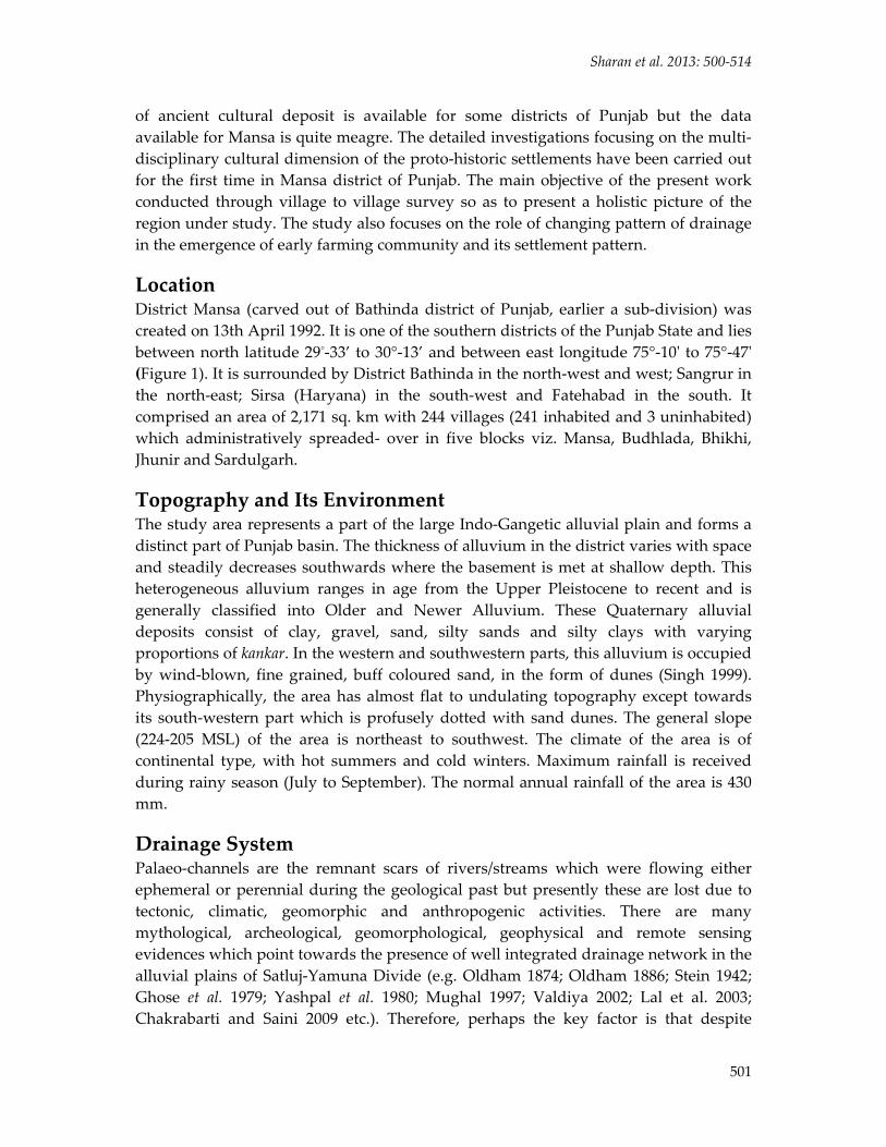
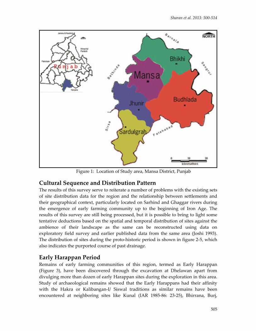
Location District Mansa (carved out of Bathinda district of Punjab, earlier a sub‐division) was created on 13th April 1992. It is one of the southern districts of the Punjab State and lies between north latitude 29°‐33’ to 30°‐13’ and between east longitude 75°‐10ʹ to 75°‐47ʹ (Figure 1). It is surrounded by District Bathinda in the north‐west and west; Sangrur in the north‐east; Sirsa (Haryana) in the south‐west and Fatehabad in the south. It comprised an area of 2,171 sq. km with 244 villages (241 inhabited and 3 uninhabited) which administratively spreaded‐ over in five blocks viz. Mansa, Budhlada, Bhikhi, Jhunir and Sardulgarh.
Topography and Its Environment The study area represents a part of the large Indo‐Gangetic alluvial plain and forms a distinct part of Punjab basin. The thickness of alluvium in the district varies with space and steadily decreases southwards where the basement is met at shallow depth. This heterogeneous alluvium ranges in age from the Upper Pleistocene to recent and is generally classified into Older and Newer Alluvium. These Quaternary alluvial deposits consist of clay, gravel, sand, silty sands and silty clays with varying proportions of kankar. In the western and southwestern parts, this alluvium is occupied by wind‐blown, fine grained, buff coloured sand, in the form of dunes (Singh 1999). Physiographically, the area has almost flat to undulating topography except towards its south‐western part which is profusely dotted with sand dunes. The general slope (224‐205 MSL) of the area is northeast to southwest. The climate of the area is of continental type, with hot summers and cold winters. Maximum rainfall is received during rainy season (July to September). The normal annual rainfall of the area is 430 mm.
Drainage System Palaeo‐channels are the remnant scars of rivers/streams which were flowing either ephemeral or perennial during the geological past but presently these are lost due to tectonic, climatic, geomorphic and anthropogenic activities. There are many mythological, archeological, geomorphological, geophysical and remote sensing evidences which point towards the presence of well integrated drainage network in the alluvial plains of Satluj‐Yamuna Divide (e.g. Oldham 1874; Oldham 1886; Stein 1942; Ghose et al. 1979; Yashpal et al. 1980; Mughal 1997; Valdiya 2002; Lal et al. 2003; Chakrabarti and Saini 2009 etc.). Therefore, perhaps the key factor is that despite
ISSN 2347 – 5463 Heritage: Journal of Multidisciplinary Studies in Archaeology 1: 2013
502
extensive debate, we still have no precise dates for when any of these channels last carried water perennially, and this has been noted previously by several scholars (Bisht 2002; Chakrabarti and Saini 2009; Singh et al. 2008).
Geomorphologically, at present the Ghaggar River is an inland and largely a seasonal stream. It take its origin from the lower Himalayas in Sirmur District, then enters the plain at Mubarakpur after running along the eastern margins of Patiala and marks the southern tips of Sangrur and Mansa Districts. It is subject to frequent flooding during the rainy season and requires control measures to be effectively taken to save the adjoining farmland. Mythlogically, a rain floodwater faded stream joining Ghaggar near Rasuli (Guhla, Kaithal) is also called, Saraswati, of Rigvedic fame, which has been closely linked with the physiographic and cultural evolution in the Satluj‐Yamuna Divide. It originates from Aadi Badri and flows through Yamunanagar and Kurukshetra before joining the Ghaggar (Valdiya 2002:116).
Anthropogenic activity seen around Sarhind Cho/Nalla (which originates near Rupnagar and flows through Malerkotla towards Sunam) has been channelized recently. Finally, it joined Ghaggar near Ladhuwas after crossing Mansa district internally. The Chos are seasonal streams, a notable feature of Satluj‐Yamuna Divide, which originates from the southern slope of Siwalik Hills. After flowing a few km, most of them either join Ghaggar River or converge into bigger streams like Sarhind Nalla. The seasonal stream is locally known as Jayantā Devi Ki Nadi in its upper course and Sunamwala or Sarhind Cho in the plain (Bhargava 1964:99). Recent study (Wilhelmy 1969:56) also indicated that Sarhind, or a different stream, is actually a palaeo‐channel of Sutlej river which probably joined Ghaggar during the Holocene period. Remote sensing data and its interpretation indicated a dried up palaeo‐channel around Rangoi Nalla (Sotter valley, Fatehabad District) which is archaeologically labelled as older course of Saraswati or Ghaggar River, on the basis of location of several proto‐historic settlements on its flood plain (Yashpal et al. 1980, Valdiya 2002).
Previous Researches and Difficulties in Present Survey The potential of rich archaeological wealth of Mansa District was brought to light by a number of archaeological surveys that have documented hundreds of sites spanning from beginning of settled village life up to the Historical and Medieval periods. The credit for initiating archaeological field work in the district goes to Jagat Pati Joshi who carried out exploration along with a team of archaeologists from ASI headed by him in 1980 which reported twenty five proto‐historic sites along the Sarhind nalla (Joshi et al. 1993:227‐56). This was followed by the excavation at Dhelawan carried out under the direction of Ms. Madhubala of ASI (IAR: 2001‐02). Dangi (2008) reinvestigated some earlier reported sites during his doctoral work. R.N. Singh et al. (2010) also undertook a village to village survey of a portion of Mansa district under the project ‘Ghaggar Hinterland Survey’.
The traditional archaeological survey is carried out by documenting the surface
Sharan et al. 2013: 500‐514
503
features of the site and its landscape and recording the artefacts and features they observe. There has been a considerable refinement to this procedure especially in the identification of particular landscapes, types of remains, and queries under consideration. During our survey of the region we faced a lot of practical problems with the available survey data. For instance, most of the sites have shown with incorrect spellings in names, incorrect geo‐coordinate and administrative locations, vague dimensions and incomplete cultural affiliation as observed earlier by Singh et al. (2011). The sites like Naiwalla‐I, II, III, IV (Barah‐I) and Baglian Da Theh (Naraderpura‐I) reported by Joshi (1993) are not known by village name but by some other local name. Even these sites show same geo‐coordinates. One of the scholars (Dangi 2011) out of confusion, perhaps, recorded incorrect locations of many sites (e.g., Churad, Dhindsa, Ganothi, Ghudhani Kalan, Moonak and Patal Kalan) in Mansa district presently but originally they were probably located in Sangrur district or elsewhere. Such problem of providing incorrect information has been encountered at sites like Guren Kalan, Lakhmirwala and Baglian Da Theh (Joshi et al. 1993) which have been found documented with larger dimensions than the existing spread of cultural deposits. There are a considerable number of sites which could not be located on the Mansa Map, e.g., Jassi Pan wala, Jodhpur Da Theh, Karanpura, Nahriwala Theh, Swawala Tibba etc (Joshi et al. 1993:252‐53) according to the descriptions of these sites provided by earlier scholars. However, in most of the earlier researches emphasis has been laid on the evidence for protohistoric settlement pattern only. In view of the above, an attempt has been made here to identify and describe sites with their true perspective.
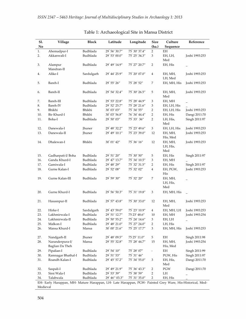
Methodology The present work is primarily based on first‐hand information, collected through extensive and intensive village to village survey of Mansa district, during July‐August 2013. A four‐member team explored all 244 villages and voyaged around 3000 km on motorbike. A total of 173 sites belonging to different periods were documented and a considerable number of these sites (around 150 sites) were previously unknown. Most of the sites are represented by thick cultural deposits but presently in highly disturbed condition due to rigorous cultivation. A large number of pottery and antiquities has been identified and documented from surface and exposed sections. During the field investigations our main emphasis was to identify the occupation of particular period on the basis of visual cultural remains. The size of sites has been estimated on the basis of the distribution of pottery on surface. In present discussion, only proto‐historic sites have been taken into consideration for the estimation of site distribution pattern. During the exploration a total of 34 sites have been documented and for better understanding, sites in the neighbourhood have also been investigated (Figure 2; Table 1). The present work is primarily based on the archaeological investigations through extensive survey conducted by us apart from the utilization of relevant and earlier published useful data. In addition, substantial help has been taken from the earlier published geomorphological features of the region.
ISSN 2347 – 5463 Heritage: Journal of Multidisciplinary Studies in Archaeology 1: 2013
504
Table 1: Archaeological Site in Mansa District Sl. No
Village Block Latitude
Longitude Size (ha.)
Culture Sequence
Reference
1. Ahemadpur‐I Budhlada 29° 56’ 30.7” 75° 30’ 37.4” 2 EH 2. Akkanwali‐I Budhlada 29° 53’ 00.0” 75° 25’ 34.3” 3 EH, LH,
Med Joshi 1993:253
3. Alampur Mandran‐II
Budhlada 29° 49’ 14.9” 75° 27’ 20.7” 2 EH, His _
4. Alike‐I Sardulgarh 29° 44’ 25.9” 75° 20’ 07.0” 4 EH, MH, LH, Med
Joshi 1993:253
5. Bareh‐I Budhlada 29° 55’ 26” 75° 28’ 52” 7 EH, MH, His Joshi 1993:253
6. Bareh‐II Budhlada 29° 54’ 32.4” 75° 30’ 26.5” 5 EH, MH, Med
Joshi 1993:253
7. Bareh‐III Budhlada 29° 53’ 22.8” 75° 28’ 44.9” 3 EH, MH _ 8. Bareh‐IV Budhlada 29° 52’ 25.7” 75° 28’ 21.6” 3 EH, LH, His _ 9. Bhikhi Bhikhi 30° 03’ 03” 75° 34’ 55” 2 EH, LH, His Joshi 1993:253 10. Bir Khurd‐I Bhikhi 30° 03’ 56.8” 76° 34’ 44.4” 2 EH, His Dangi 2011:70 11. Boha‐I Budhlada 29° 50’ 03” 75° 33’ 36” 2 LH, His,
Med Singh 2011:97
12. Danewala‐I Jhuner 29° 48’ 32.2” 75° 23’ 49.6” 3 EH, LH, His Joshi 1993:253 13. Danewala‐II Jhuner 29° 49’ 10.1” 75° 23’ 39.0” 12 EH, MH,
His, Med Joshi 1993:253
14. Dhalewan‐I Bhikhi 30° 01’ 42” 75° 36’ 16” 12 EH, MH, LH, His, Med
Joshi 1993:253
15. Gadharpati‐I/ Boha Budhlada 29° 51’ 20” 75° 30’ 50” 5 EH, His Singh 2011:97 16. Gandu Khurd‐I Budhlada 29° 47’ 13.7” 75° 34’ 10.5” 3 EH, MH _ 17. Gamiwala‐I Budhlada 29° 48’ 29” 75° 32’ 31.5” 2 EH, His Singh 2011:97 18. Gurne Kalan‐I Budhlada 29° 52’ 08” 75° 32’ 02” 4 EH, PGW,
His Joshi 1993:253
19. Gurne Kalan‐III Budhlada 29° 59’ 30” 75° 32’ 20” 7 EH, MH, LH, His, Med
_
20. Gurne Khurd‐I Budhlada 29° 56’ 50.3” 75° 31’ 19.8” 3 EH, MH, His _
21. Hasasnpur‐II Budhlada 29° 57’ 43.8” 75° 30’ 33.0” 12 EH, MH, Med
Joshi 1993:253
22. Hirke‐I Sardulgarh 29° 43’ 59.0” 75° 23’ 10.9” 4 EH, MH, LH Joshi 1993:253 23. Lakhmirwala‐I Budhlada 29° 51’ 12.7” 75 23’ 48.6” 10 EH, MH Joshi 1993:254 24. Lakhmirwala‐II Budhlada 29° 50’ 55.2” 75° 24’ 14.6” 3 EH, LH _ 25. Malkon‐I Budhlada 29° 48’ 21.0” 75° 27’ 24.0” 2 LH, His 26. Mansa Khurd‐I Mansa 30° 00’ 21.6” 75° 25’ 17.7” 3 EH, MH, His Joshi 1993:253
27. Nandgarh‐II Jhuner 29° 48’ 09.5” 75 25’ 11.0” 5 EH Singh 2011:98 28. Naranderpura‐I/
Baglian Da Theh Mansa 29° 55’ 32.8” 75° 28’ 44.7” 15 EH, MH,
His, Med Joshi 1993:254
29. Pipalian‐I Budhlada 29° 54’ 10” 75° 28’ 07” ‐ EH Singh 2011:99 30. Ramnagar Bhathal‐I Budhlada 29° 51’ 53” 75° 31’ 46” PGW, His Singh 2011:97 31. Roandh Kalan‐I Budhlada 29° 45’ 57.2” 75° 34’ 55.0” 3 EH, His,
Med Dangi 2011:70
32. Saspali‐I Budhlada 29° 49’ 21.9” 75° 36’ 43.3” 2 PGW Dangi 2011:70 33. Sirsi Wala‐I Budhlada 29° 53’ 39” 75° 38’ 59” 2 LH _ 34. Talabwala Budhlada 29° 46’’ 03.3” 75° 31’ 35.0” 2 EH, His _ EH‐ Early Harappan, MH‐ Mature Harappan, LH‐ Late Harappan, PGW‐ Painted Grey Ware, His‐Historical, Med‐ Medieval
Sharan et al. 2013: 500‐514
505
Figure 1: Location of Study area, Mansa District, Punjab
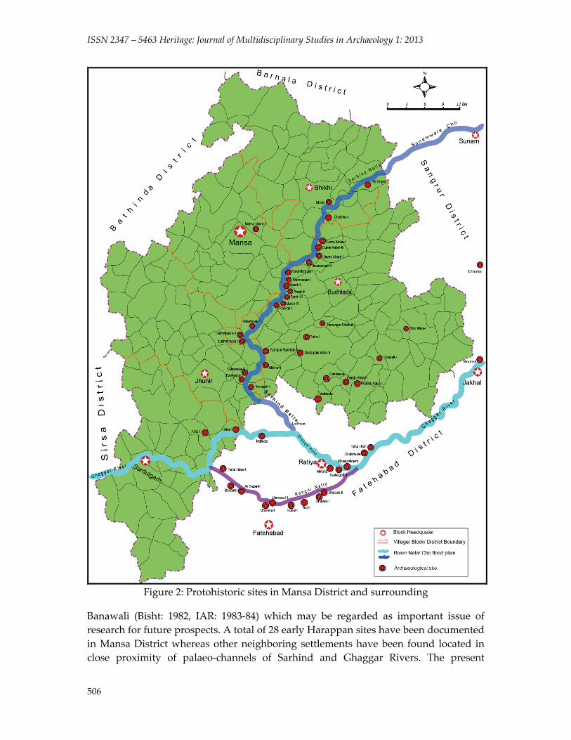
Cultural Sequence and Distribution Pattern The results of this survey serve to reiterate a number of problems with the existing sets of site distribution data for the region and the relationship between settlements and their geographical context, particularly located on Sarhind and Ghaggar rivers during the emergence of early farming community up to the beginning of Iron Age. The results of this survey are still being processed, but it is possible to bring to light some tentative deductions based on the spatial and temporal distribution of sites against the ambience of their landscape as the same can be reconstructed using data on exploratory field survey and earlier published data from the same area (Joshi 1993). The distribution of sites during the proto‐historic period is shown in figure 2‐5, which also indicates the purported course of past drainage.
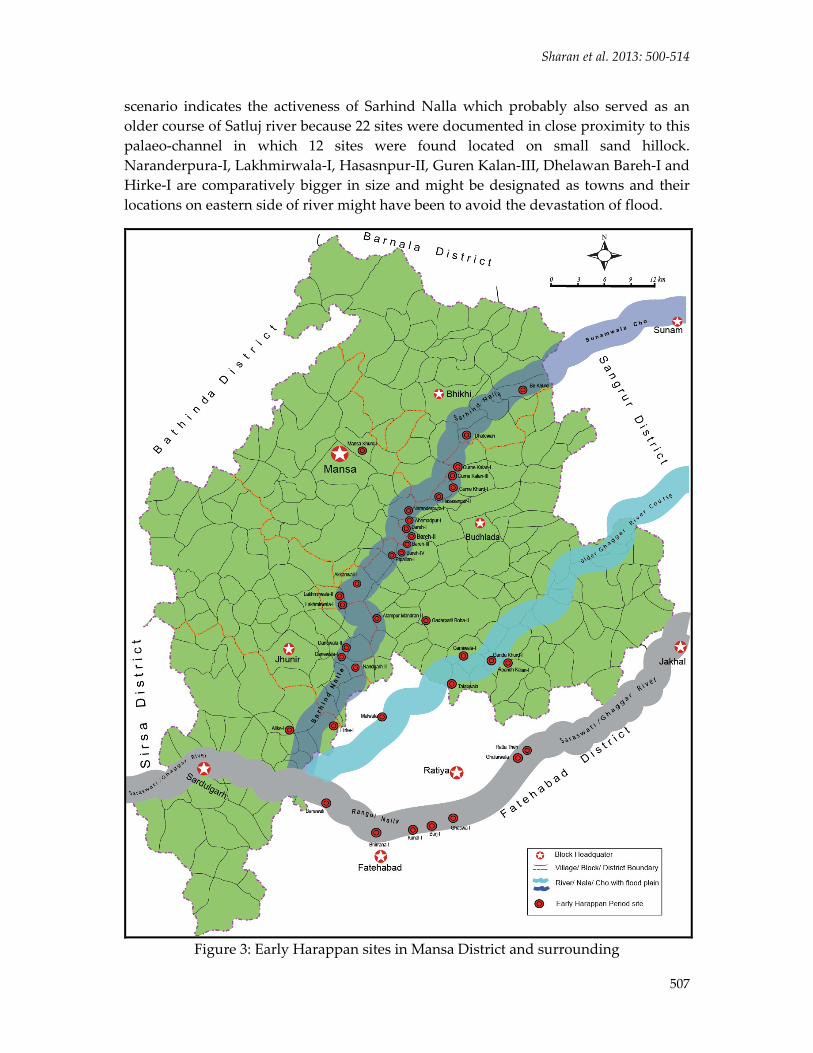
Early Harappan Period Remains of early farming communities of this region, termed as Early Harappan (Figure 3), have been discovered through the excavation at Dhelawan apart from divulging more than dozen of early Harappan sites during the exploration in this area. Study of archaeological remains showed that the Early Harappans had their affinity with the Hakra or Kalibangan‐I/ Siswal traditions as similar remains have been encountered at neighboring sites like Kunal (IAR 1985‐86: 23‐25), Bhirrana, Burj,
ISSN 2347 – 5463 Heritage: Journal of Multidisciplinary Studies in Archaeology 1: 2013
506
Figure 2: Protohistoric sites in Mansa District and surrounding
Banawali (Bisht: 1982, IAR: 1983‐84) which may be regarded as important issue of research for future prospects. A total of 28 early Harappan sites have been documented in Mansa District whereas other neighboring settlements have been found located in close proximity of palaeo‐channels of Sarhind and Ghaggar Rivers. The present
Sharan et al. 2013: 500‐514
507
scenario indicates the activeness of Sarhind Nalla which probably also served as an older course of Satluj river because 22 sites were documented in close proximity to this palaeo‐channel in which 12 sites were found located on small sand hillock. Naranderpura‐I, Lakhmirwala‐I, Hasasnpur‐II, Guren Kalan‐III, Dhelawan Bareh‐I and Hirke‐I are comparatively bigger in size and might be designated as towns and their locations on eastern side of river might have been to avoid the devastation of flood.
Figure 3: Early Harappan sites in Mansa District and surrounding
ISSN 2347 – 5463 Heritage: Journal of Multidisciplinary Studies in Archaeology 1: 2013
508
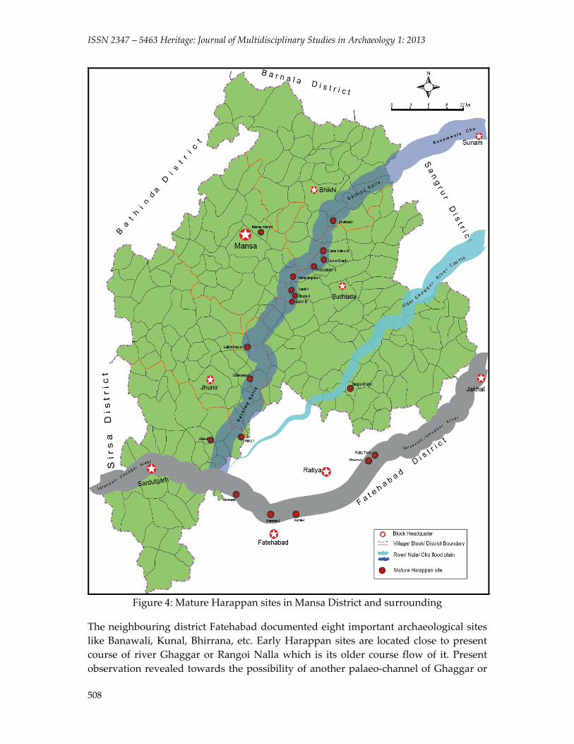
Figure 4: Mature Harappan sites in Mansa District and surrounding
The neighbouring district Fatehabad documented eight important archaeological sites like Banawali, Kunal, Bhirrana, etc. Early Harappan sites are located close to present course of river Ghaggar or Rangoi Nalla which is its older course flow of it. Present observation revealed towards the possibility of another palaeo‐channel of Ghaggar or
Sharan et al. 2013: 500‐514
509
its tributary like Patiala Rao flowed in upper reaches and joined Ghaggar river near Banawali. Six sites were documented on its lower course.
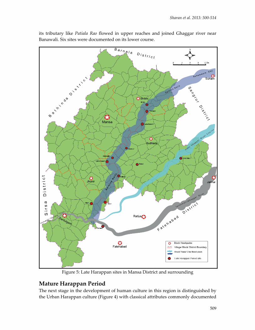
Figure 5: Late Harappan sites in Mansa District and surrounding
Mature Harappan Period The next stage in the development of human culture in this region is distinguished by the Urban Harappan culture (Figure 4) with classical attributes commonly documented

ISSN 2347 – 5463 Heritage: Journal of Multidisciplinary Studies in Archaeology 1: 2013
510
at many sites during the exploration besides excavations at Dhelawan. Analysis of ceramic assemblages of the above sites apart from earlier studies showed the presence of very limited classical Harappan elements (Sharma 1982). One interesting feature is that 4 small sites with early to late Harappan occupational remains are situated in sandy area. Reason for the non occurrence of classical Harappan elements, at these small sites, has been most effectively expressed by R.S. Bisht (1977; IIAS, Shimla) in the following words:
Figure 6: PGW sites in Mansa District and surrounding
Sharan et al. 2013: 500‐514
511
“Qualitative and quantitative presence of the classical Harappan elements were dependent on the socio‐economic or political status of a given site.”
However, present field survey revealed only bigger sites (Town) which are urban in nature. These sites exhibited the presence of classical Harappan pottery and other antiquities. Out of total 14 sites of Mature Harappan, 12 sites are located on the Sarhind palaeo‐course in which only 3 sites showed their habitation on sand dune. Most of the sites on sand dune emerging during the early Harappan period showed disappearance in the mature Harappan period whereas the sites located on alluvium showed continuous occupation. The notable feature of mature Harappan period as observed in present exploration is that only one site has been found located on the older palaeo‐channel of Ghaggar representing burial site in nature. It is likely that this course disappeared or changed to join the Saraswati near Rasuli (Kaithal) as presently observed. Most of the sites are located in the proximity of Ghaggar River in Fatehabad showed continuous occupation during the mature Harappan period as supported by larger dimensions of sites and reflected through rich material culture.
Late Harappan Period The Late Harappan phase (Figure 5), known as Bara culture, has been established by the excavations at Ropar (Rupnagar District), Mardkheda, Rohira and Mahorana (Sangrur District) and many other explored sites characterized by an overall degeneration in the material culture showing decline in their arts, crafts, trade and commerce and municipal regulation on the urban site, particularly. To summarise the Harappan settlement in Punjab B.B. Lal expressed:
“…the overall picture in the upper Sutlej valley highlights a local pottery tradition termed as Baran. It is in this milieu that the mature Harappan made its appearance. However, in due course of time the Harappan elements became feeble but the Baran continued”. (Lal 1997: 268).
Present exploration documented total of 11 late Harappan sites out of these 8 are on sand dunes. Sarhind palaeo‐channel again shows well populated area as 9 sites are located on it while the Ghaggar/ Saraswati River showed absence of sites during this period except at Banawali. Evidences indicate that the flow of Sarhind Nalla has not changed much from the proto‐historic times whereas shifting in the courses has prominently been documented in the Saraswati/ Ghaggar river basin.
Painted Grey Ware Period The last phase of the proto‐historic habitation is marked by the advent of the Painted Grey Ware (Figure 6) using people, whose remains have been reported from four sites during the course of explorations besides the excavations at Rohira and Mahorana. But an important feature of this period is that all the sites are situated on the upper reaches of the palaeo‐channels of the rivers. Only 2 sites are located on the banks of Sarhind Nalla which probably points towards its dry condition. Concentration of more sites on Ghaggar/ Saraswati river basin may be due to the availability of more water. But all the

ISSN 2347 – 5463 Heritage: Journal of Multidisciplinary Studies in Archaeology 1: 2013
512
sites on both the river basin are small in dimension and located on the middle of palaeo course that is also an indication of gradual disappearance of this stream either due to weak Monsoon or gradual change in their courses.
Discussion Importance of regional study has been advocated by Subbarao who while stressing for the need to understand the smaller units in totality rightly viewed that ‘a distinct geographical pattern emerges in the development and spread of culture… influencing and absorbing the regional and local forms and manifestation’ (Subbarao 1958:2‐3).
Topographically, Mansa District has vast agricultural land to maintain large populations as alluvial fertile soil spread by monsoon faded rivers; climatically, this region is very congenial for human occupation and hydrologically, perennial rivers were available for irrigation and trade. Although, none of the above features was permanently stable as is clear from present survey. The alluvial soil, strong monsoon and Perennial Rivers made favourable condition for early farming community which terms as early Harappan. The newly habited comes with the knowledge of metal, agriculture and domestication while favourable environment gives acceleration to their growth as sound rural culture that also supported by thickly populated sites found during present exploration in Mansa district.
At the time of middle of third millennium BC older Ghaggar River course change forced the population to be shifted toward Sarhind and Saraswati river basin. The new arrival at these sites gives more head and hand, so that the mature Harappan sites showed enlargement in size and population. One another important impact on social structure that is expressed by various scholars as variation in social order/ class, domestic architecture and material, manufactured artifacts at the different settlements which were the essential components of its urban culture. The rank size categorization of site as city, town, village, hamlet etc. also showed complex cultural structure in this basin. Nevertheless, this observation is done on the basis of material remains recovered in present exploration on various sites. The weak monsoon and dryness of Saraswati / Ghaggar River made their impact on desertion of urban sites at its basin. It affected also economic structure of settlements survived on Sarhind Nalla which shows only either variation in material or sophistication of artifacts. No drastic changes in population were observed on river basins but settlements showed degradation in its urban nature. The diffusion of local cultures also affected the major outcome of these changes termed as Bara culture.
The PGW period marked big transformation in settlement pattern on Sarhind Nalla as attested by scanty sites. It might be the result of dryness of Sarhind Nalla where solitary site was found on it, while Saraswati basin shows good concentration of habitation. This moisture containing dry palaeo‐channel might be providing them more grazing land for domestication and agricultural field as we found that all the sites are located in upper part of rivers. Regional archaeology in most of the cases exhibit
Sharan et al. 2013: 500‐514
513
new and unexpected results, with enduring value and may be considered as a base for other studies undertaken at different scales. It is (or should be) the essential step for heritage preservation.
Acknowledgements We are extremely grateful to Prof. Amar Singh, M.D. University, Rohtak for his guidance and assistance. The authors also like to acknowledge Dr. Ravinder Kumar, DIHRM, Delhi for a critical analysis of a previous version of this manuscript. Special thanks to Mr. Omvir Jangra for his generous support during the fieldwork.
References Bhargava, M.L. 1964. The Geography of Rgvedic India.Lucknow: The upper India Publishing
House Ltd. Bisht, R.S. 1976. Transformation of the Harappan Culture in Punjab with special reference to
the excavations at Sanghol and Chandigarh. In B.N. Chakravarty (ed.) Archaeological Congress and Seminar: 1972:16‐22. Kurukshetra:Kurukshetra University.
Bisht, R.S. 1987.Further Excavations at Banawali 1983‐84. InB.M. Pandey and B.D. Chattopadhyaya (ed.) Archaeology and History. New Delhi.
Chakarabarti, D.K. and S. Saini. 2009. The Problem of the Sarasvati and Note on the Archaeological Geography of Haryana and Indian Punjab. New Delhi: Aryan Books International.
Dangi, V. 2011. Explorations along the Ghaggar River and Sarhind Nalla in Haryana and Punjab. Man and Environment 36 (2): 66‐87.
Danino, M. 2010. The Lost River‐ On the trial of the Sarasvati. Delhi: Penguin. Ghose, B. et al. 1979. The Lost Courses of the Saraswati River in the Great Indian Desert. The
Geographical Journal 145(3):446‐51. IAR: Indian Archaeological – A Review. New Delhi: Archaeological Survey of India. Joshi, J.P. and M. Bala.1993. Excavations at Bhagwanpura 1975‐76 and other explorations
and excavations 1975‐81 in Haryana, Jammu and Kashmirand Punjab. Memoirs of the Archaeological Survey of India 89: 227‐56.
Joshi, J.P., M. Bala and J. Ram. 1984. The Indus Civilization: a reconsideration on the basis of distribution maps. In BB Lal and SP Gupta (ed.) Frontiers of the Indus Civilization:511‐30.Delhi:Books and Books.
Khatri, J.S. and M. Acharya.1995.Kunal: A New Indus‐Saraswati Site. Puratattva :25. Kumar, A. 2008. Hydrogeological and geochemical studies of part of Sirhind Nala Sub Basin of
Ghaggar River Basin, In relation to buried Aravali‐ Delhi ridge, south‐west Punjab, India. Chandigarh: Department of Geology, Panjab University, (Unpublished Ph.D. Dissertation).
Lal, B.B. 1997. The earliest civilization of south Asia: Rise, maturity and decline. New Delhi: Aryan Book International.
Lal, B.B. et al. 2003.Excavations at Kalibangan: The Early Harappans. New Delhi: The Director General, Archaeological Survey of India, Janpath,.
ISSN 2347 – 5463 Heritage: Journal of Multidisciplinary Studies in Archaeology 1: 2013
514
Madhu, B. 1992. Archaeology of Punjab. Delhi: Agama Kala Prakashan. Mughal, M.R. 1997. Ancient Cholistan: Archaeology and Architecture. Ferozsons Publication,
Lahore. Oldham, C.F. 1874. Notes on the Lost river of the Indian Desert. Calcatta Review 59:1‐29. Oldham, R.D. 1886. On Probable Changes in the Geography of the Punjab and its Rivers: an
Historical‐geographical study. Journal of the Asiatic Society of Bengal 55(2):322‐343.
Punjab District Gazetteer‐ Bathinda. 1992. Revenue Department, Punjab. Rao, L.S. et al. 2006. Bhirrana Excavation: (2005‐06). Puratattva 36:45‐49. Sehgal. J. L., Bajwa, M.S. and Sharma, P.K. 1992. Soils of Punjab. InResearchBulletin. No. 31.
NBSS and LUP Publication, Nagaur. pp. 1‐12. Shaffer, Jim G. 1981. The Protohistoric period in the eastern Punjab: a preliminary
assessment. In A.H. Dani (ed.)Indus Civilization: New Perspectives :65‐102.Islamabad:Quaid‐I‐Azam University.
Sharma, Y.D. 1979. Harappan complex on Sutlej (India). Paper presented at seminar on the Harappan Civilization in India Subcontinent. Srinagar.
Sharma, Y.D. and G.B. Sharma. 1982. Bara culture and its housing remain with special reference to Sanghol. In R.K. Sharma (ed.)Indian Archaeology: new perspectives :71‐82. New Delhi:Agam Kala Prakasan.
Sharma, Y.D.1987.Fresh light on the Bara culture from Mahorana. In B.M. Pande and B.D. Chattopadhyaya (ed.)Archaeology and History: Essays in memory of Sh. A. Ghosh:157‐176. Delhi: Agama Kala Prakashan.
Singh, G. 1999. Quaternary geology and geomorphology of Bathinda and Sangrur districts, Punjab. Gondwana Geological Magazine14(1): 57‐68.
Singh, R.N. et al. 2011. New insights into Settlement along the Ghaggar and its Hinterland: a Preliminary Report on the Ghaggar Hinterland Survey 2010. Man and Environment 36(2): 88‐106.
Srivastava, G.S., I.B. Singh and A.K. Kulshrestha. 2006. Late Quaternary geomorphic evolution of Yamuna Sutlej interfluve: significance of terminal fan. Journal of the Indian Society of Remote Sensing 34(2):23‐30.
Stein, M.A. 1942. A Survey of Ancient Sites along the ʺLostʺ Sarasvati River.The Geographical Journal 99:173‐82.
Subbarao, B. 1958. The personality of India. Baroda: M.S. University Archaeology Series‐3. Valdiya, K. S. 2002. Saraswati: The River that Disappeared. Hyderabad: University Press. Wheeler, M. 1950. The Marett Memorial Lecture given at Exeter College, Oxford on 7th June,
1952, and here printed In Antiquity XXIV:126. Wilhelmy, H. 1967. The shifting river: studies in history of Indus valley. Universtas X(1): 53‐
68. Yashpal, et al. 1980. Remote sensing of the Lost Sarasvati River. Proceeding of the India
Acenary of Sciences 89(3):317‐31.